Early Los Angeles Water Reservoirs
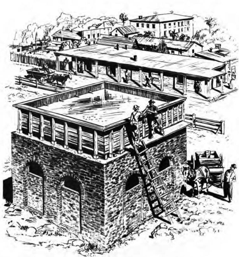
LA's First Above Ground Stone Reservoir (1858)
 |
|
| (ca. 1860)* - Sketch showing the first stone reservoir in Los Angeles, located in the center of the city plaza. It was fed by the Zanja Madre, LA's original aqueduct. |
Historical Notes In 1858, the LA Water Works Co., headed by William G. Dryden, constructed a large brick and wood storage tank in the center of the city plaza. It would remain there for about 10 years and then be replaced by a fountain. Water would continue to be stored in other tanks on the periphery of the plaza as well as in other nearby reservoirs. In 1876, the Buena Vista Reservoir in Elysian Park was built by the privately-owned Los Angeles Water Co. The LA Water Co., headed by John S. Griffen, Solomon Lazard, and Prudent Beaudry, signed a 30 year lease franchise agreement with the City to run it's water system (1868 - 1898). Click HERE to read more history in Water in Early Los Angeles. |
.jpg) |
|
| (ca. 1860)* - One of Los Angeles' first water reservoirs was the brick structure shown in the center of the Plaza. The adobe directly behind was owned by Augustin Olvera. The 3-story building behind was the Sisters of Charity Hospital.* |
 |
|
| (ca. 1858)* - This is the earliest known photograph of the Los Angeles Plaza. There is a square main brick reservoir in the middle of the Plaza, which was the terminus of the town's historic lifeline: the Zanja Madre ('Mother Ditch'). |
 |
|
| (1863)^ - A water wheel on the Los Angeles River at start of Zanja Madre, LA's original aqueduct. The river has been the life-source of Los Angeles since it was settled in 1781. |
Historical Notes The 40 ft. water wheel seen above was used to raise a portion of the Los Angeles River water supply to a height permitting gravity flow to homes, fields and storage. In 1857, William Dryden was granted a franchise by the City Council to construct a system to provide a water supply. Under this system a brick reservoir was built in the center of the plaza to store the water brought to it by the Zanja Madre. A water wheel was also constructed to lift the water from the river to the Zanja Madre. Water then was distributed to a number of houses along the principal streets through a system of wooden pipes. Click HERE to read more about William Dryden. |
 |
|
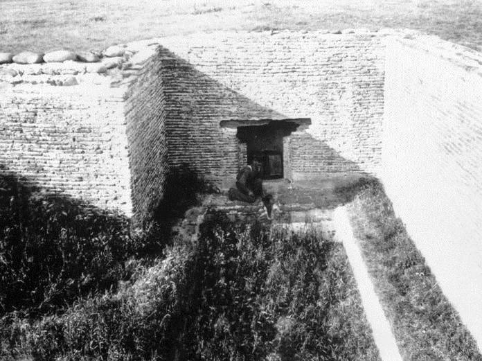
| (n.d.)* - Ruins of early LA reservoir |
LADWP Historic Archive
Dryden Springs, formerly known as Abila Springs, was located on the land below the mesa, where College Street would run into Alameda Street today. The Council turned down the proposition, stating that it was no hardship for the citizens to get their water from the zanjas as they had done for more than 70 years. Four years later, on February 24, 1857, Judge Dryden, with a man named McFadden, established the nucleus of a water system and was granted a franchise to distribute water from his land and to build a water wheel which was to be installed in the Zanja Madre. The water was conveyed to the Plaza, where Dryden, in 1860, erected a small brick reservoir, about 20 by 30 feet in size and standing about 18 feet high, the bottom of the water tank being 10 feet above the ground. The tank was filled by means of pumps, and the water distributed from there to the consumer through pipes made from hollowed logs. This was the first attempt to pipe water in the city of Los Angeles or to distribute it to the consumer, except by water carrier. The little brick reservoir stood in the Plaza for 10 years. When no longer needed, it was removed. Judge Dryden died here on September 10, 1869, at the age of 70, after a colorful career of nearly two decades in the city.
Click HERE to read more about LA's early water works system.
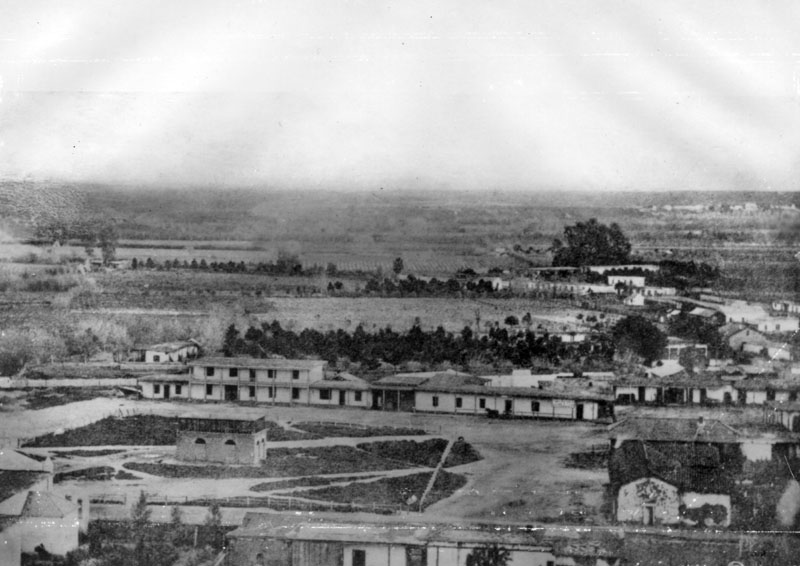
Buena Vista Reservoir (1869)
.jpg) |
|
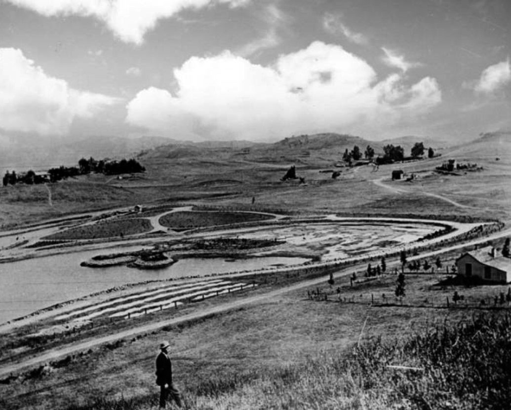
| (1876)* - Buena Vista Reservoir in Elysian Park. Built in 1869 by the privately-owned LA City Water Co. this was the company's first water storage facility. Photo shows reservoir seen from the hills, looking east from present-day location of the Pasadena Freeway. |
Historical Notes Buena Vista Reservoir was built by the LA City Water Company in 1869 and enlarged in the 1880s. It was the City's 1st large scale water reservoir. In 1868, Prudent Beuadry, John S. Griffen, and Solomon Lazard, three of the city's more successful businessmen, submitted a proposal to the city council to develop and operate the city's water system. In turn they asked for all of the city's water rights and control over the water rates. They also promised to construct a reservoir for the city, lay twelve miles of iron pipe, install fire hydrants at major street crossings, provide free water to public buildings, and to erect an ornamental fountain in the city plaza. The city approved the franchise agreement on a 30 year lease basis. Beaudry, Griffen, and Lazard incorporated as the Los Angeles City Water Company which would operate the City's water system until 1902 when the newly created LA City Water Department was established.. |
 |
|
| (Early 1900s)^* - View of Buena Vista Reservoir looking northeast with trees and buildings in the background. |
 |
|
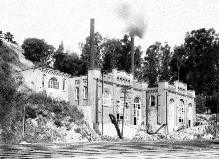
| Buena Vista Pumping Station was located at the edge of Elysian Park, east of the North Figueroa Street Bridge, and faced the Los Angeles River. It was placed in operation by the Water Bureau in 1904. The original plant replaced a water wheel, located in the near vicinity. It pumped water from Buena Vista to Solano and Highland Reservoirs.* |
Historical Notes One of the first installations, the Buena Vista Pumping Station consisted of a vertical shaft, 14-ft in diameter, which connected with a tunnel which ran to about the present site of the Lincoln Heights City jail (1939). The tunnel tapped water from infiltration galleries, carrying it by gravity flow to the shaft. Water was lifted by a big pump, submerged at the bottom of the shaft and operated by rods driven by a steam engine.* |
 |
|
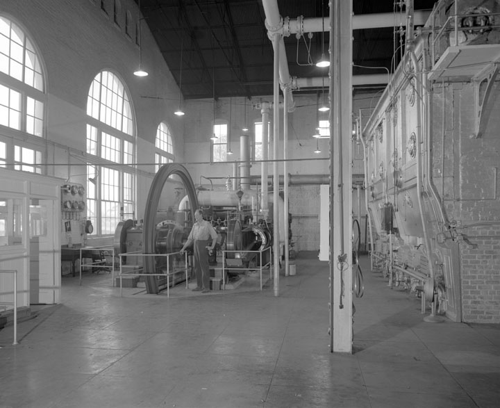
| (1930s)* - Interior view of the Buena Vista Pumping Plant. |
 |
|
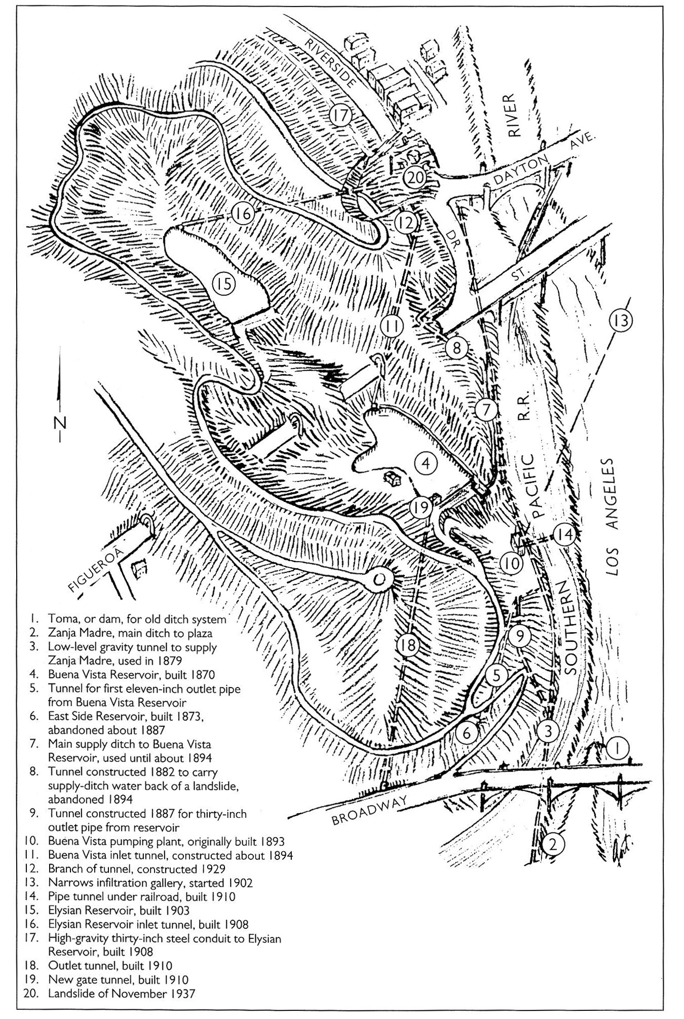
| (1938)^^* - Map of the Elysian Park area showing waterworks structures dating from Zanja Madre days to 1937. |
 |
|
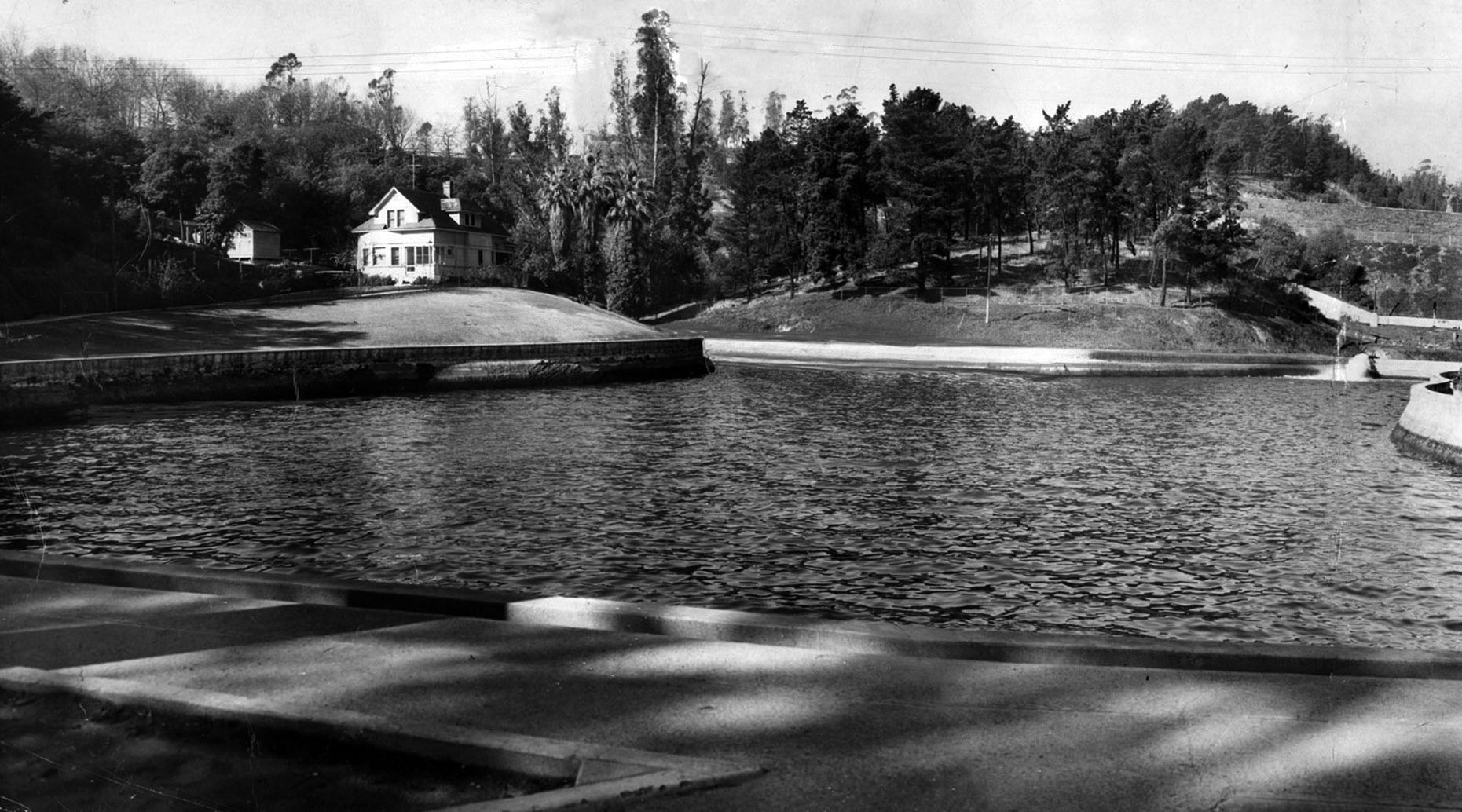
| (1949)* - View of caretaker's home at Buena Vista Reservoir in Elysian Park, alongside the Arroyo Seco Parkway. This panorama was made from two prints. Paul Calvert / Los Angeles Times |
Historical Notes Buena Vista Reservoir, was the granddaddy of all downtown reservoirs. It long was hidden in the hills of Elysian Park – until they put through the Pasadena Freeway, which zoomed right past this old water hole built in 1869. |
 |
|
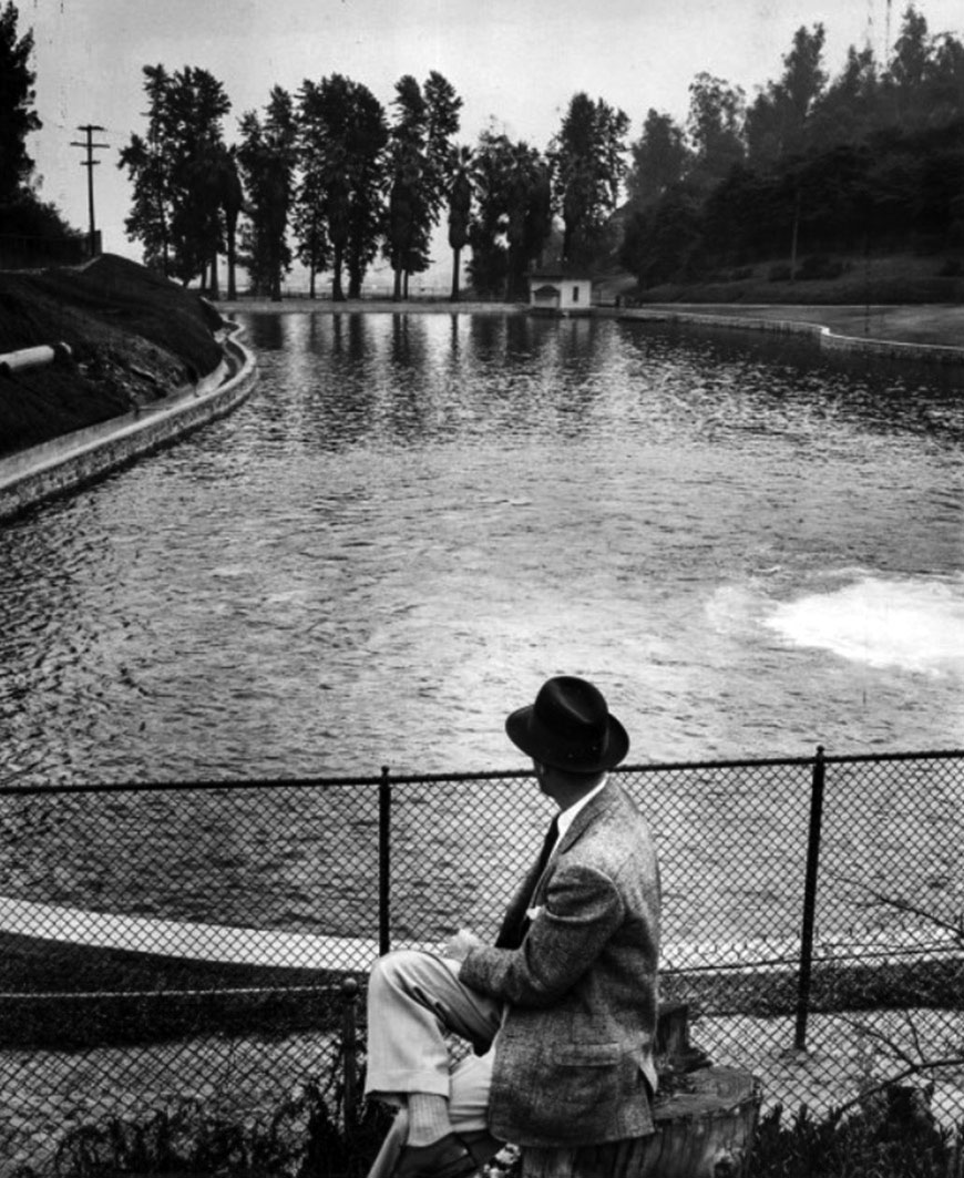
| (1955)* - A man looks out toward Buena Vista Reservoir in Elysian Park. Built in 1869, this was Los Angeles’ first major scale water reservoir. |
Historical Notes A year after the above photo was taken, the reservoir was drained and abandoned. The location is now the Buena Vista Meadow picnic area. |
* * * * * |
Reservoir No. 4 (Echo Park Lake - 1868)
 |
|
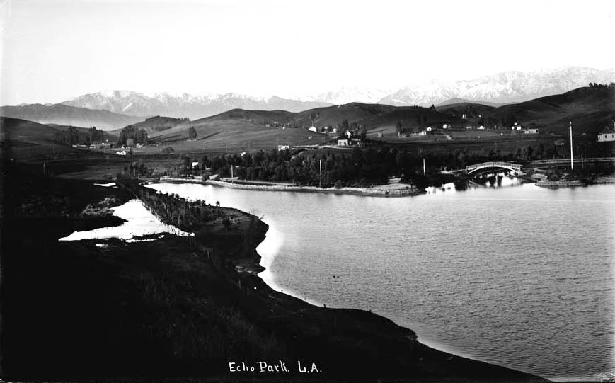
| (ca. 1894)^ - Early view of Echo Park Lake, looking northwest towards the Santa Monica Mountains. The dirt road running along the lower half of the image is Montana Street, which would later become Echo Park Avenue. Trees and farmhouses pepper the landscape, and a man is visible at the bottom. |
Historical Notes Echo Park Lake didn’t start out as a man-made lake. Instead, its earliest use by the city was as a reservoir, storing water in a section sometimes known as the city’s “West End.” In those years this area was thought of as the city’s west side. The Los Angeles Canal and Reservoir Co. formed Reservoir No. 4 in 1868. The company obtained the water by digging a ditch that sent water flowing from the Los Angeles River – in the area now known as Los Feliz – along a zigzag path that merged with the Arroyo de los Reyes and then emptied into the reservoir.* The Arroyo de los Reyes originates near the Catholic school on Glendale Boulevard – right by the 2 off-ramp. It flowed southward, along Glendale Boulevard, occupied the area now taken by Echo Park Lake, and continued down to 2nd Street, then crossing through downtown LA, about a block or two south of Pershing Square, where it spread and created a big muddy mess. These flows eventually connected with the Los Angeles River, when they didn’t seep into the ground first.^ |
 |
|
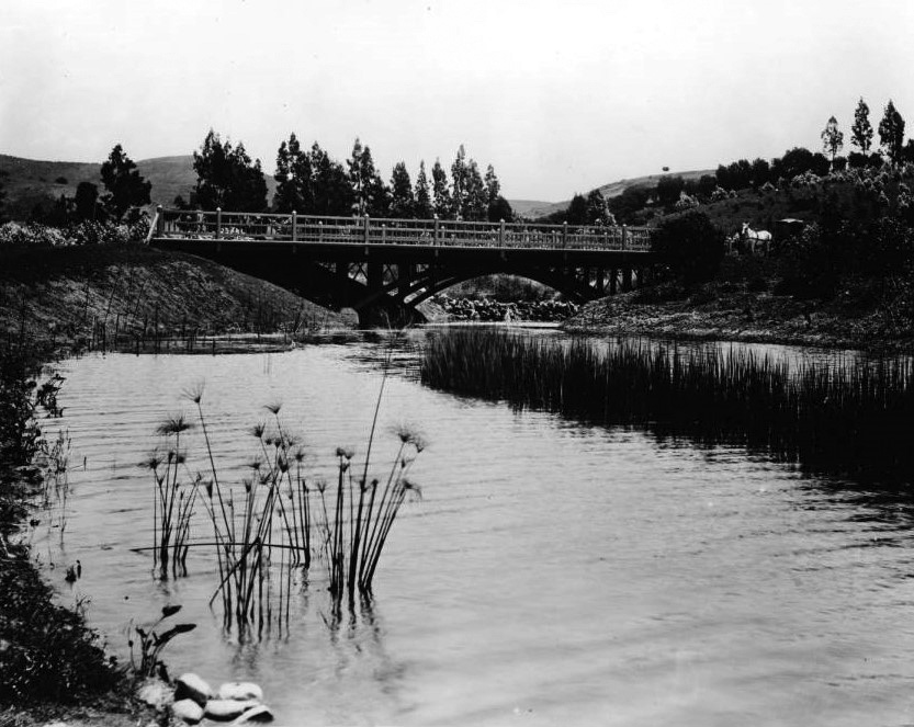
| (ca. 1895)^## - View looking northeast showing Echo Park with the snow-capped peaks of the San Gabriel Mountains in the distance and rolling countryside all around. Note the arched wooden bridge at center-right. |
Historical Notes In the late 1880s, a carriage maker turned real estate developer, by the name of Thomas Kelley, teamed up with other investors to purchase about 70 acres that included Reservoir No. 4—what is now Echo Park Lake. Kelley and his business partners sold off pieces of what they called the Montana Tract to individuals who built the business district along Sunset Boulevard and the densely packed homes and apartments that surround Echo Park Lake.* |
.jpg) |
|
| (ca. 1895)^## - View looking east showing Echo Park Lake and surrounding area with bridge seen at center-left. |
Historical Notes In those years, Reservoir No. 4 was held in check by a dam in the vicinity of Bellevue Avenue. From there, water traveled down the Woolen Mill Ditch to a mill near present-day Fifth and Figueroa Streets, not far from where Kelley lived. Kelley petitioned the city to provide a quitclaim, essentially a land swap, converting the reservoir lands into a park and private residences. That request, and quite possibly a legal challenge, led to three years of debate by the parks commission, the city council and the mayor.* |
.jpg) |
|
| (ca. 1895)^## - View looking south toward Bellevue Avenue and the dam holding up the lake, showing houses on bluff at left, a bank with trees on right, and two small wooden boats at center. |
Historical Notes In 1891, the city’s health officer inspected the lake's dam and determined that, if it were to hold a greater volume of water, it would pose a danger to residents who lived south of Bellevue Avenue. Two months later, city leaders struck a deal with the men who owned the land around the reservoir. Kelley and his associates – including William LeMoyne Wills, who like Kelley, would later serve on the school board – gave up 33 acres of land around the reservoir so that it could be used as a park. In exchange, the city agreed not to overflow the reservoir land, making the remaining land held by Kelley and his associates – including the street that would soon become Sunset Boulevard – far more valuable. When Mayor Henry Hazard signed the paperwork in 1891 allowing the park to be created, he envisioned a grand boulevard on Alvarado Street that would transport residents from Westlake – now MacArthur Park – to Echo Park Lake and then northeast to Elysian Park.* |
 |
|
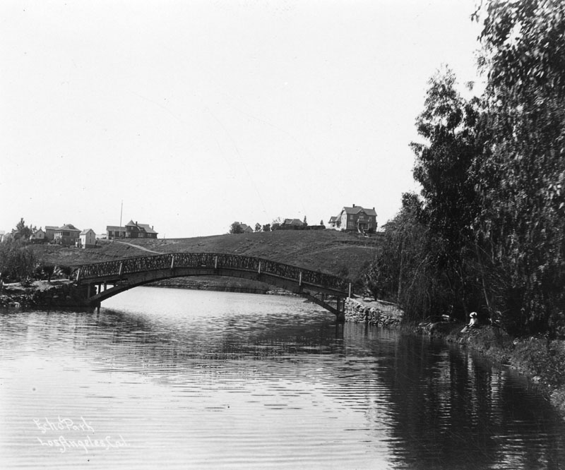
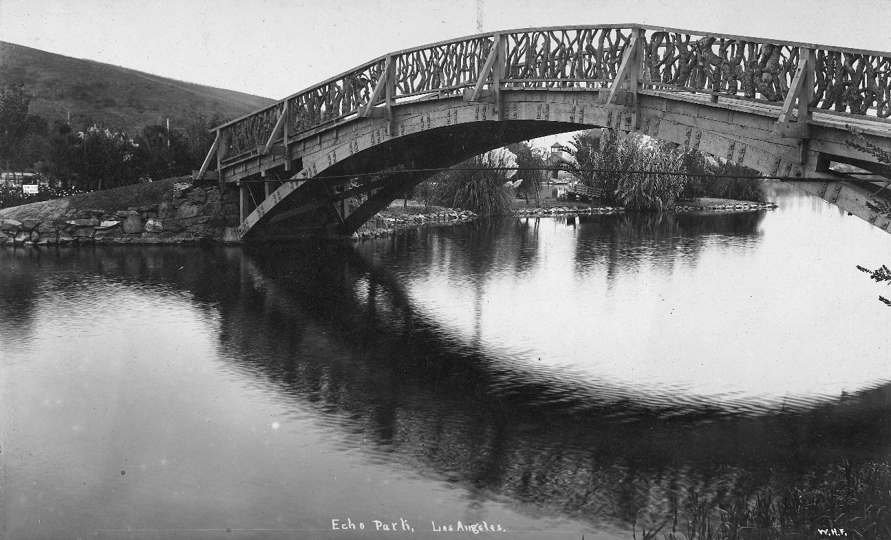
| (1900)* - Wooden bridge over Echo Park Lake as it looked at the turn of the century. Note the homes on the hillside behind the bridge and the woman with the hat relaxing alongside the lake. |
Historical Notes Designed in the rustic style, one of the lake's two bridges helped pedestrians reach the island seen on the left, while a second bridge passed over the lake’s northwest corner, where the ditch delivered water from the Los Angeles River (and lotus now grow). The city began work landscaping the park in October 1892. By 1895, the park and accompanying boathouse were completed. |
 |
|
| (ca. 1895)^## – Close-up view looking south showing one of the two wooden bridges at Echo Park Lake. The bridge rail is made from fitted gnarled branches. In distance is a park bench and boathouse. |
Historical Notes The city began work landscaping the park in October 1892. By 1895, the park and accompanying boathouse were completed. |
 |
|
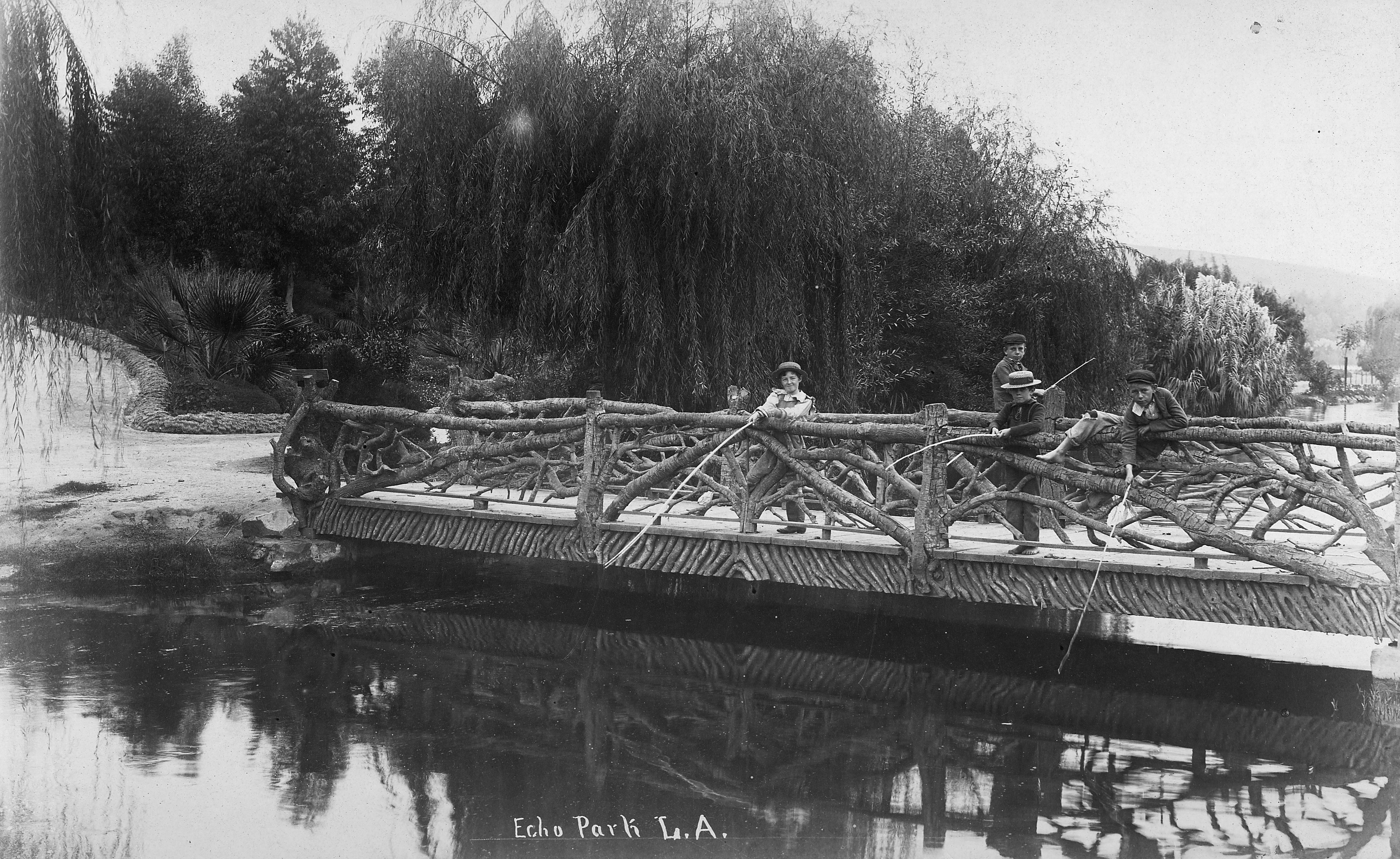
| (1890)* - View showing four boys fishing off one of the two bridges at Echo Park Lake with willow trees in the background. Note the “tree-limb” railing. |
Historical Notes The above bridge passed over the lake’s northwest corner, where the ditch delivered water to the lake from the Los Angeles River (where the lotus now grow). The city began work landscaping the park in October 1892. By 1895, the park and accompanying boathouse were completed. |
 |
|
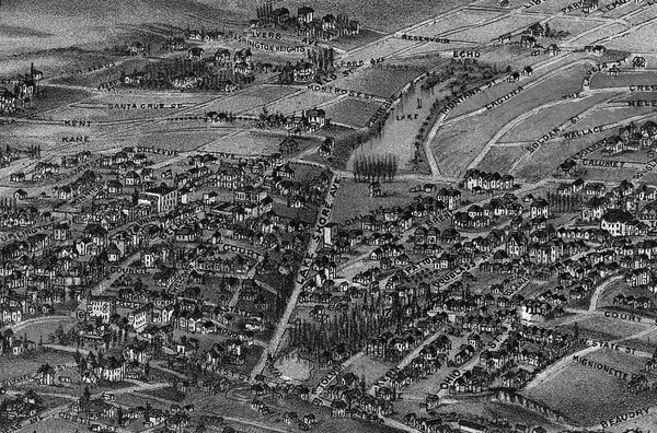
| (1894)*#*– Map showing Echo Park Lake (center-top) located at the intersection of Lake Shore Avenue (later Glendale Boulevard) and Bellevue Avenue. Note that there is a second smaller lake seen at lower-center. It was part of the Second Street Park, located at the intersection of Lake Shore Avenue and 1st and 2nd streets. Map courtesy of the Library of Congress. |
Before and After
|
|
 |
|
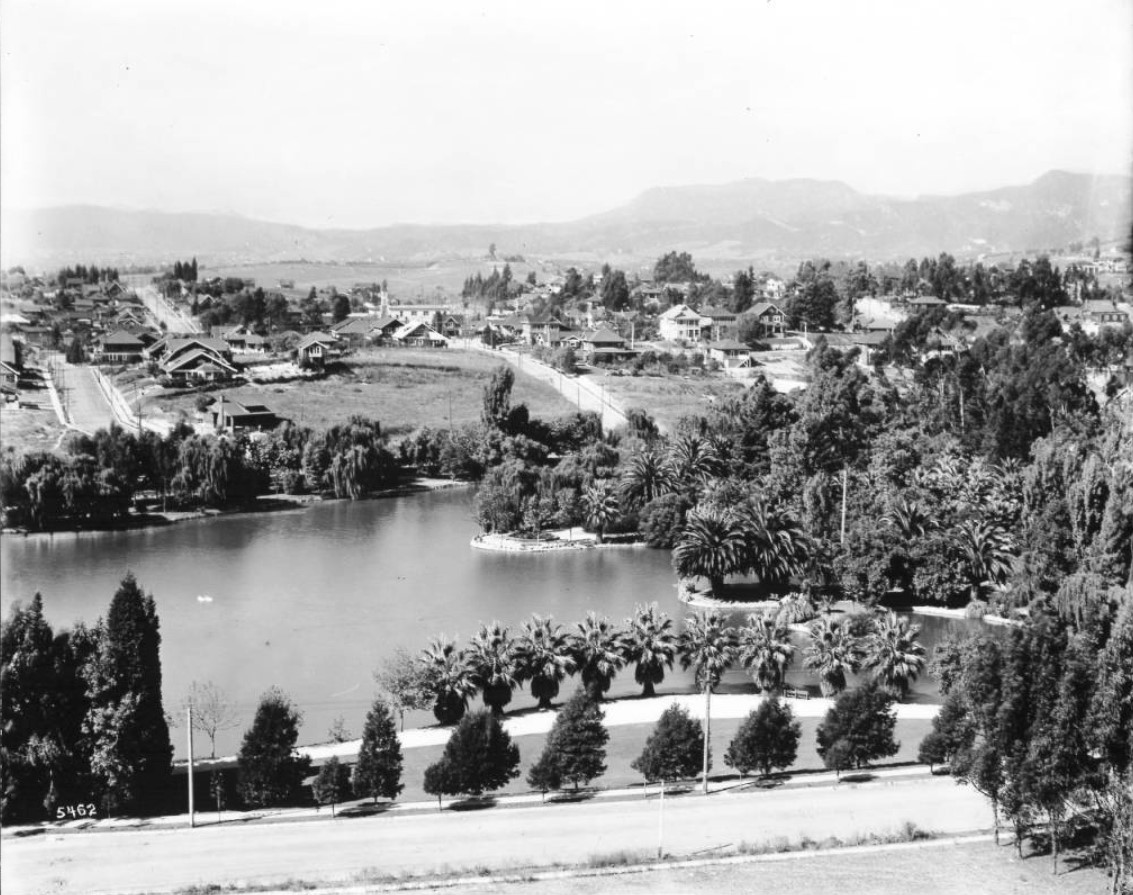
| (ca. 1894)^ vs. (1911)^^ - Echo Park Lake before and after landscaping. |
Historical Notes Echo Park development began in 1891 with landscaping a year later. The first Superintendent of Parks for the city was an English immigrant named Joseph Tomlinson who was assigned the task of creating the park. Mr. Tomlinson, being somewhat homesick for his favorite park in Derbyshire, England, decided to model the park after his favorite childhood place to play. At the same time, the reservoir was closed and the stream was capped. The park superintendent created a 16-acre lake where the reservoir had been. It cost $5,637.00 to create the lake that is now filled with city water. Once that was accomplished, the planting began on the other 15 acres of park. One day, while overseeing the work, Mr. Tomlinson thought he heard his workers talking during a break, but he knew they were across the park from him. The park had an echo! He knew what the name of the park would be! Unfortunately, the plantings he installed destroyed the echo, but the name remained. The park was dedicated and opened to the public in 1895. The famous bed of lotuses that grow in the lake at the northwest end of the park, the largest stand of lotuses outside Asia, is a mystery yet to be solved. One legend says that evangelical Chinese missionaries planted them for use as food, but no one knows the real story. They appeared some time in 1923 or 1924. Nonetheless, they remain a beautiful addition to the park and have inspired the city to sponsor the annual Lotus Festival that celebrates Asian and South Pacific Island cultures.^^ By 1899, city leaders were intent on adding even more green space, by extending the parkland south to Temple Street. Bounded by Temple on the south and Bellevue on the north, the area was completed by 1907, with an extensive network of playing fields and courts for tennis and croquet. Called Echo Park Playground, it was only the second public playground to be built in the city of Los Angeles and still remains today. Click HERE to see more on the Echo Park Playground. Click HERE to see more contemporary views of Echo Park Lake (1975+). |
* * * * * |
Eastlake Park (Lincoln Park)
 |
|
| (ca. 1880)#* – View showing a stream and foot bridge in Eastlake Park (later Lincoln Park). A line of marsh grass is pictured to the right, emerging from the center of the stream. In the background, the foot bridge can be seen extending over the water, with a horse-drawn carriage visible on the right bank. |
Historical Notes Originaly Eastlake Park and Westlake Park were built as a drinking water reservoirs connected to the city's systems of zanjas (small conveyance channels/trenches). When the city abandoned the non-pressurized zanja system for a pressurized pipe system, these smaller, shallow reservoirs located at low points no longer provided much benefit. They were then converted into parks.*^* |
 |
|
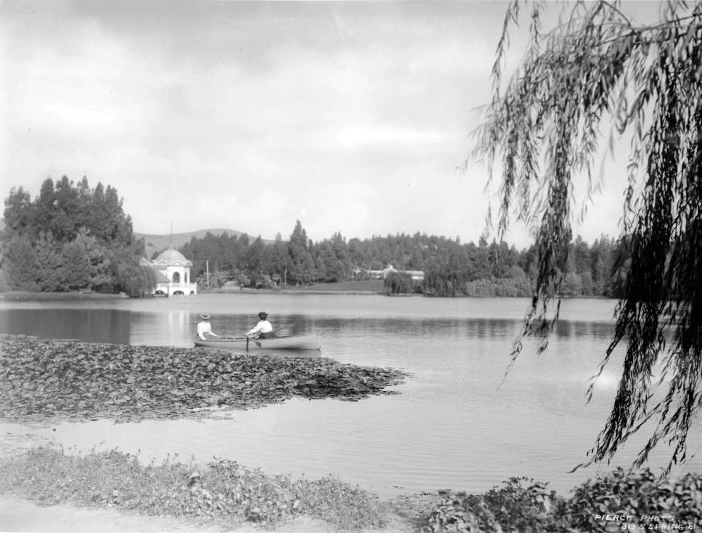
| (ca. 1900)#* – Photo showing two women wearing long-sleeved blouses and hats in a small canoe on a large lake at Linocoln Park. In the background at left, a large cylindrical structure with a domed roof is visible. A smaller building can be seen at right. |
Historical Notes Lincoln Park was originally created by the City of Los Angeles in 1881, from land donated by John Strother Griffin. It was one of Los Angeles' first parks. It was originally called East Los Angeles Park. By 1901 it had become a major amusement center for the people of Los Angeles, and it was at this time that the name was changed to Eastlake Park. On May 19, 1917, the park was renamed Lincoln Park after Lincoln High School.^* |
 |
|
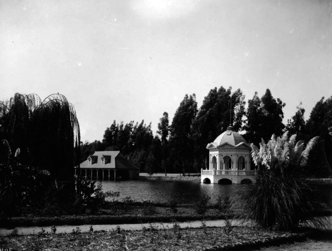
| (ca. 1900)#* - View showing Eastlake Park (later Lincoln Park). A boat house stands on the lake in background while a lightly-colored, extravagant gazebo stands on the water's edge at right. Flowers line a pathway in the foreground while tall trees stand across the far side of the lake. |
 |
|
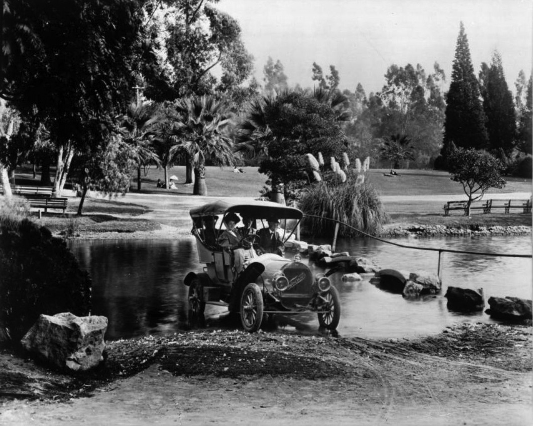
| (ca. 1908)#* – View showing a 1908 "Tourist" automobile driving through a stream in Eastlake Park (later Lincoln Park). The lightly-colored automobile is being driven by a woman with a man seated next two her and two women in the back. Across the stream, more park patrons can be seen enjoying an open expanse of lawn. |
* * * * * |
Westlake Park (later MacArthur Park)
 |
|
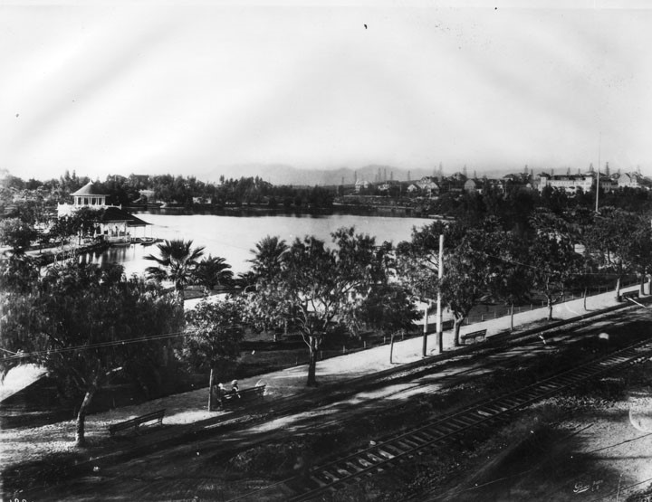
| (ca. 1880s)^* - Panoramic view looking northwest showing Westlake Park (now MacArthur Park) at the intersection of 7th and Alvarado streets. Alvarado runs diagonally from lower-left to center-right. The surrounding hills are devoid of homes and trees. The building on the far left is the boathouse. |
Historical Notes The park, originally named Westlake Park, was built in the 1880s, along with a similar Eastlake Park, whose lake is artificial. Westlake Park was renamed MacArthur Park on May 7, 1942; Eastlake Park was renamed Lincoln Park. Originally Westlake Park and Eastlake Park (as well as Echo Park) were built as drinking water reservoirs connected to the city's systems of zanjas (small conveyance channels/trenches). When the city abandoned the non-pressurized zanja system for a pressurized pipe system, these smaller, shallow reservoirs located at low points no longer provided much benefit. They were then converted into parks.*^* |
 |
|
| (1880s)^* - View looking northwest of Westlake Park and its boathouse. The Hollywood Hills stand in the background (top-right). |
 |
|
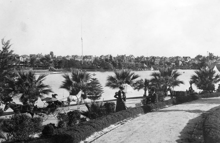
| (ca. 1895)^* - View of Westlake Park (now MacArthur Park) circa 1895. Transportation was still mostly by horse and carriage (lower left of picture) and ladies carried parasols to shade themselves from the sun. Multi-story homes fill the hill on the other side of the lake. A 150-foot tall streetlight stands in front of the row of homes. |
Historical Notes Wilshire Boulevard formerly ended at the lake on its west side, but in 1934 a berm was built for it to cross and link up with the existing Orange Street (which ran from Alvarado to Figueroa) into downtown Los Angeles. Orange Street was renamed Wilshire and extended east of Figueroa to Grand Ave. This divided the lake into two halves; the northern one was subsequently drained.*^* |
 |
|
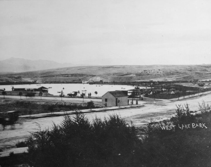
| (1907)^* - View looking northeast of Westlake Park (later McArthur Park) from 7th Street. A tree-lined walkway with benches is seen on the edge of the park. Trolley tracks run down an unpaved 7th Street. Oil derricks are seen in the hills across the lake. |
Historical Notes In 1890, Edward Doheny struck oil south of Angelino Heights and Echo Park, triggering the city’s first oil boom. Soon, hundreds of wells were pumping away in a wide belt stretching roughly south of Temple Street. For decades the wells would change the landscape of the City.*** Westlake Park was renamed MacArthur Park on May 7, 1942.*^* Click HERE to see more Views of Westlake Park (MacArthur Park) in the 1920s + |
* * * * * |
Garvanza Reservoir (1902)
 |
|
| (ca. 1930s)* - View of Garvanza Reservoir. The concreted lined and covered reservoir was located south of Meridian St. between N. Ave 63 and N. Figueroa St. , Highland Park. It was acquired in February 1902 and enlarged 1907. |
Historical Notes In 1989, the Garvanza Pumping Station and site of Highland (Garvanza) Reservoir was dedicated as L.A. Historic-Cultural Monument No. 412 (Click HERE to see complete listing). |
 |
|
| (n.d.)* - Early view of the Garvanza Pumping Plant |
* * * * * |
Solano Reservoir (1904)
 |
|
| (1920s) - The Solano Reservoir was located southwesterly of Spruce Street at Jarvis Street and Alley, Elysian Park. It held 5.8 million gallons of water and was put in service in 1904. |
* * * * * |
Ivanhoe Reservoir (1906)
 |
|
| (1930s)* - Ivanhoe Reservoir - The reservoir was put in service May 1906. It was enlarged in 1952, and taken out of service November 1993, and it was put back in service July 1994. |
 |
|
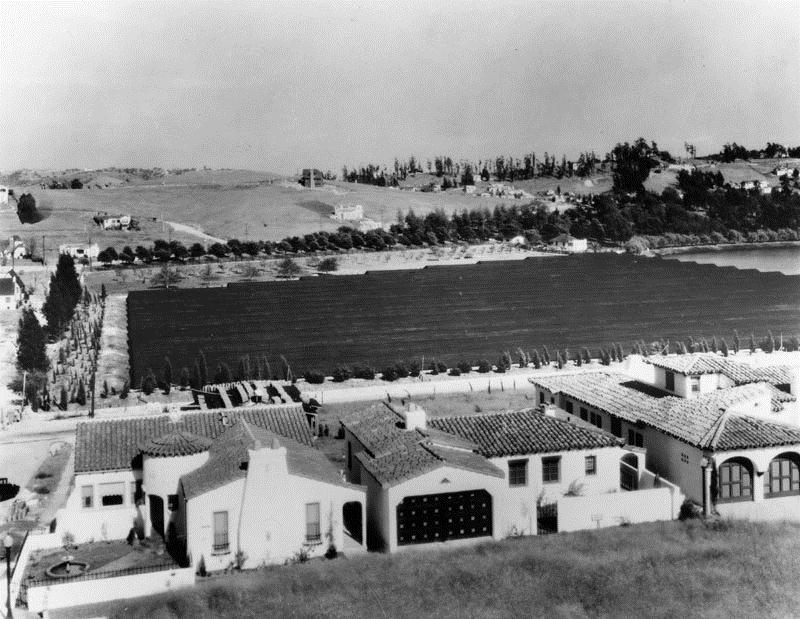
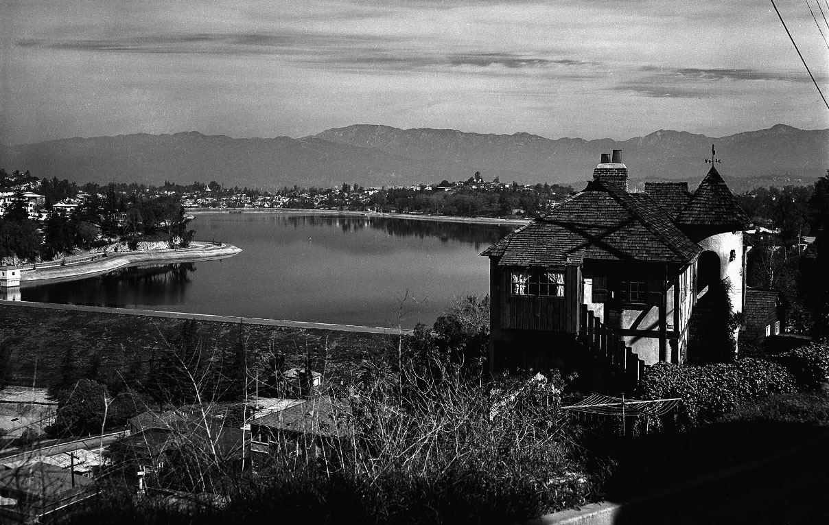
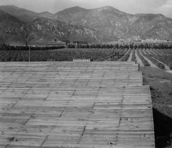
| (1930)* - View looking east towards the Ivanhoe Reservoir, near the intersection of Tesla and W. Silver Lake Drive. The black structure shown over the reservoir is a cover made of wood and black roofing material. Various houses, most of which are in the California Spanish style, are visible throughout the image. Silver Lake Reservoir, which adjoins Ivanhoe, is not covered because of its larger area, greater depth and more active water circulation. |
* * * * * |
Silver Lake Reservoir (1907)
 |
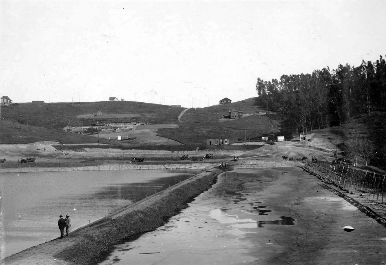
(1906)++ - View showing the construction site of the Silver Lake and Ivanhoe Reservoirs. |
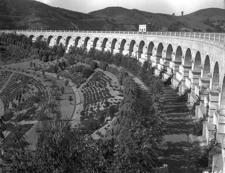
Historical Notes The City of Los Angeles acquired a portion of the land that is now the Silver Lake and Ivanhoe reservoirs in the 1880’s and the remainder of the land in 1904 through a process of condemnation. Designed by Chief Engineer, William Mulholland, utilizing an innovative technique known as hydraulic sluicing, the construction of the reservoirs began with Ivanhoe in 1906, followed by Silver Lake, completed in 1907.++ |
 |
|
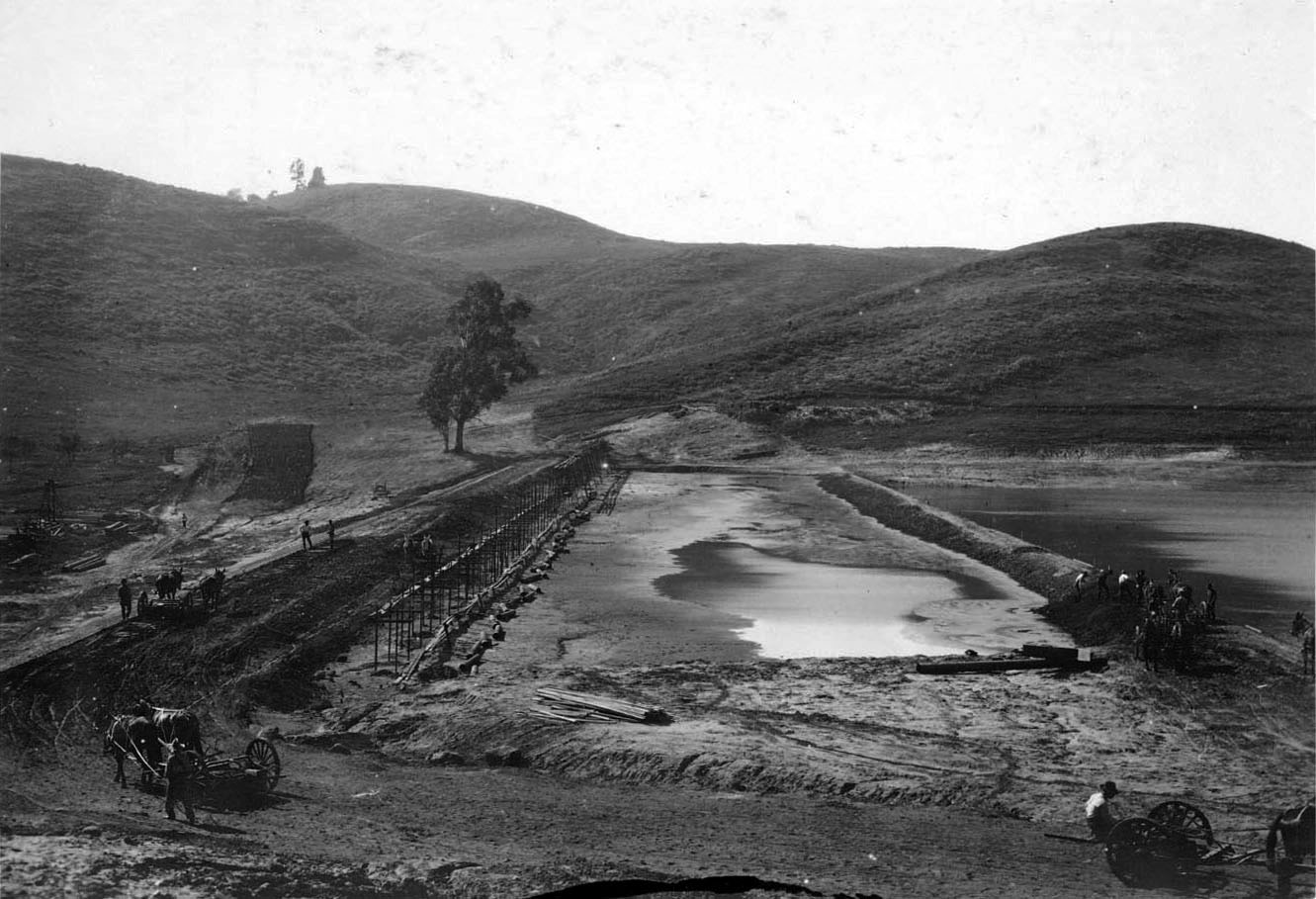
| (1907)^^^ - Silver Lake Dam, looking north, during construction. Water Resources Collections, UCR Libraries |
Historical Notes To create the dam, Mulholland first encased a wall of riveted steel plates in three feet of concrete. He then turned hydraulic jets upon the floor of Ivanhoe Canyon, sluicing away a deep trough and flinging the detritus uphill upon the concrete to create a reinforced earthen dam.* |
 |
|
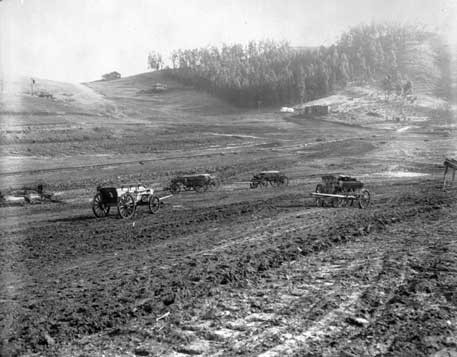
| (1907)#* - View showing men operating horse-drawn ploughs grading the land adjacent to the newly constructed Silver Lake Reservoir located in the Ivanhoe Canyon. |
Historical Notes In 1896 Herman Silver was elected to the Los Angeles City Council and was soon voted its President – acting often as the Mayor pro tem of the city. In 1902, the City Council created a the 1st Water Commision and named Herman Silver as its Chairman. Silver was instrumental in planning a reservoir Northeast of Downtown that would combine stored water with a development of nice homes and parks. The next Mayor came into office and failed to re-appoint Silver to the Water Board – for political reasons. The City Council reacted – praising Herman Silver by naming the new water project after him. The area has been known, ever since, by the name – Silverlake. *# |
 |
|
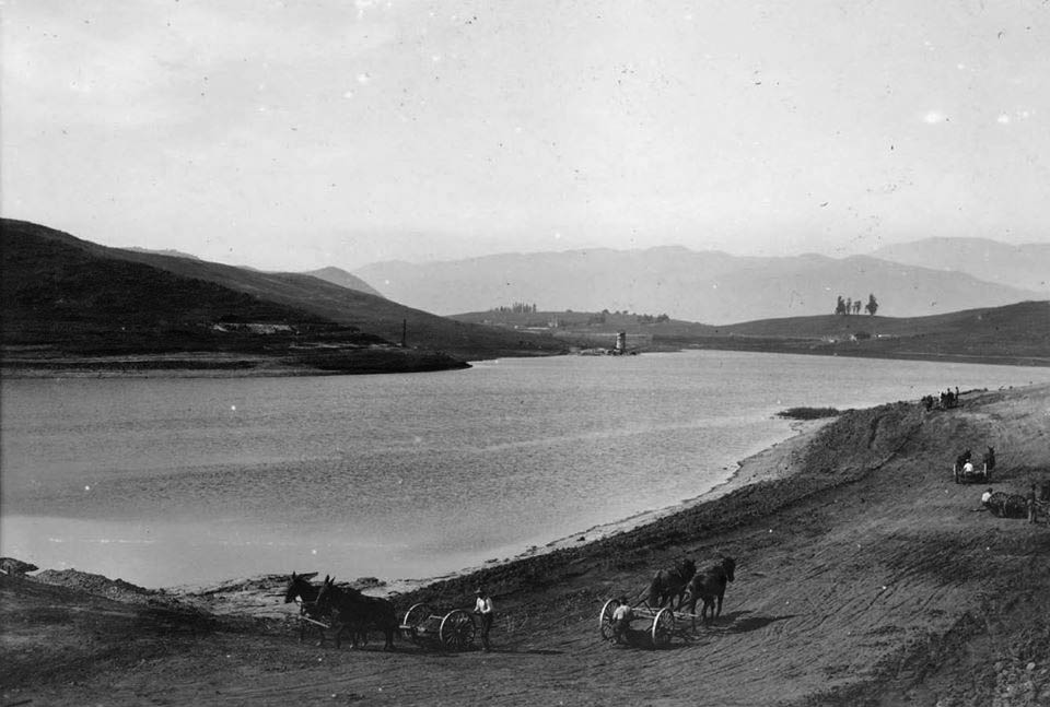
| (1907)^^^ – Two men stand on edge of the new Silver Lake Dam looking out toward the reservoir. In the distance can be seen several homes scattered on the hillside. |
Historical Notes Once completed, the new reservoir ensured a constant supply of water for Los Angeles. Its 767 million gallons—pumped from the ground beneath the Los Angeles River near Griffith Park—could quench the city’s thirst for three weeks uninterrupted if all other sources suddenly turned dry.*. |
 |
|
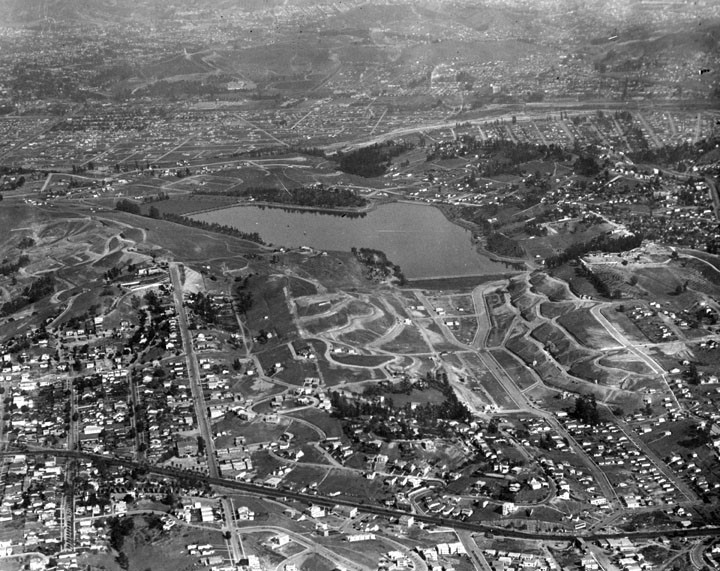
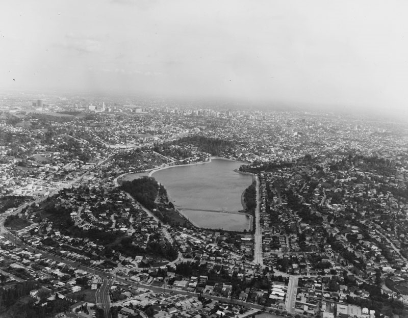
| (1924)^* - Seen from the air is a large body of water (the Silver Lake Reservoir) and the surrounding housing and development of the Moreno Heights-Silver Lake subdivision of L.A. |
Historical Notes Silver Lake also doubled as a scenic and recreational asset. Unlike nearby Ivanhoe Reservoir—completed a few years earlier and covered in wooden boards—the new lake lay bare to the world, offering itself up as scenery. A stock of black bass attracted fishing, and the then-unfenced lakeshore invited Angelenos to stroll around their drinking water supply. By 1912 the city’s parks department had planted more than 2,000 eucalyptus trees on the slopes of Ivanhoe Canyon, and a utilitarian water storage facility had become a prized public space.* |
 |
|
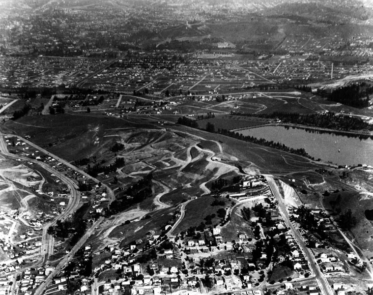
| (ca. 1924)^* - Aerial view of Silver Lake Reservoir and surrounding area, with streets readied for houses. View is looking north. |
 |
|
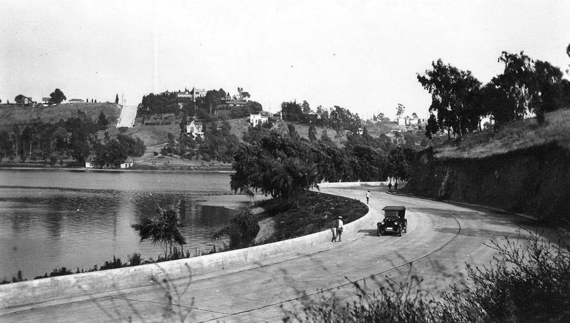
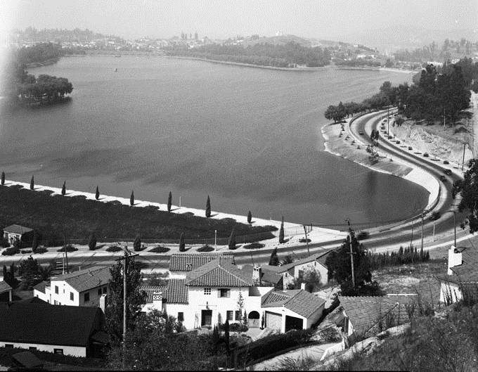
| (1927)#+– Panoramic ground level view showing Silver Lake Reservoir. Two people are seen strolling along the road adjacent to the reservoir as an early model car rounds the curve. |
 |
|
| (1930)* - Silver Lake Reservoir - Silver Lake Reservoir was named for Herman Silver, first president of the Board of Commissioners, Domestic Water Works System. He served from 1902-1903. The reservoir is a earth fill dam, asphalt concrete, with paved slopes. It was put into service in May 1908. |
 |
|
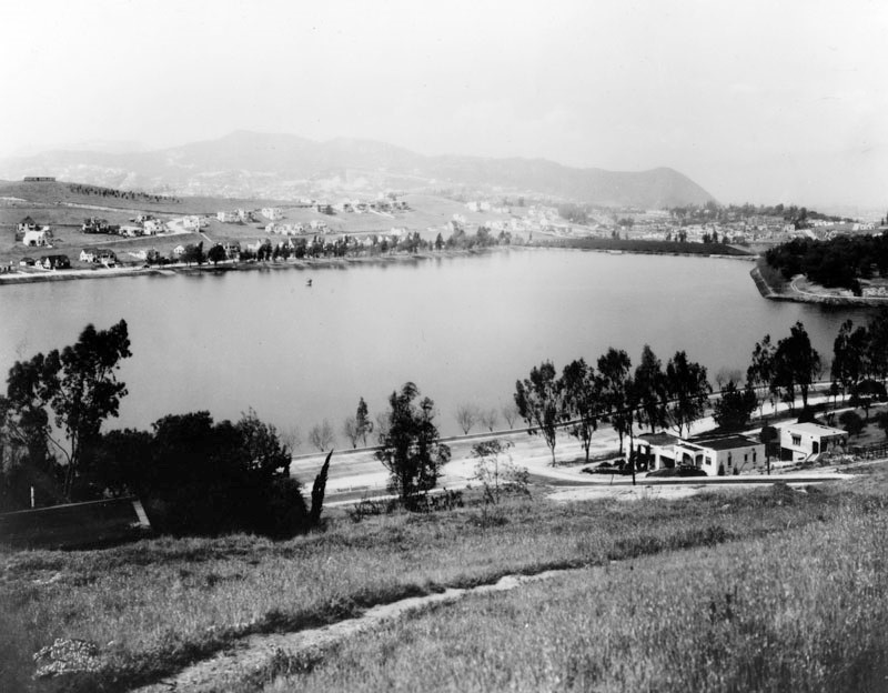
| (ca. 1935)^* - View of Silver Lake Reservoir, looking northwest from the southeast. Various houses, many of which are in the California Spanish style, are visible throughout the image. Note the open space between the homes. |
 |
|
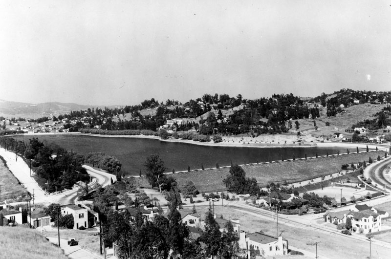
| (ca. 1936)^* - View of the reservoir, looking northeast from the southwest. The original Silver Lake Recreation Center can be seen at the intersection of Van Pelt and W. Silver Lake Blvd. |
 |
|
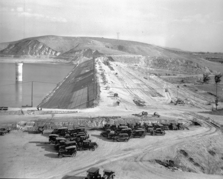
| (1930s)* - View of the Silver Lake Reservoir expansion construction, with many workers using picks and shovels and wheelbarrows. |
 |
|
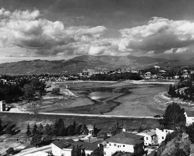
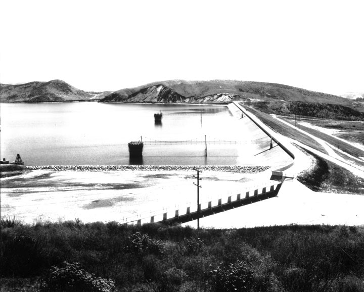
| (1932)* - Panoramic view of the Silver Lake Reservoir after it was retrofitted and expanded in 1932. The Department of Water and Power established these reservoirs in the early 1900s as part of the city-wide system of water storage and delivery. |
 |
|
| (1956)+# – View of Silver Lake Reservoir, looking north toward the mountains. |
Historical Notes The prime real estate around the lake is known by realtors as the "Moreno Highlands." |
 |
|
| (1973)^* - Aerial view of Silver Lake, looking southeast. |
Historical Notes In 1989, the Silver Lake Reservoir was designated LA Historic-Cultural Monument No. 422 (Click HERE to see complete listing). |
* * * * * |
Lower Van Norman Reservoir (aka Lower San Fernando Reservoir)
 |
|
| (1930)* – View showing construction work at the Lower San Fernando Reservoir, originally built in 1913. |
Historical Notes The Los Angeles Aqueduct enters the San Fernando Valley, discharging into the Upper San Fernando Reservoir and then into the Lower San Fernando Reservoir. In 1930, the Los Angeles Bureau of Water Works and Supply (later LADWP) began work to increase the storage capacity of the Lower San Fernando Reservoir. |
 |
|
| (1930)* - View showing the Lower San Fernando Reservoir (later named Lower Van Norman Reservoir) after expansion. |
Historical Notes The capacity of the Lower San Fernando increased from 14,000 to 18,000-acre feet by raising the height of the earth fill dam there 12 feet. The dam is 2,400 feet long. |
 |
|
| (1935)^^ - Aerial view of the Lower Van Norman Reservoir looking northeast. Rinaldi Street runs east to west in the foreground. |
Historical Notes The reservoir was later named after Harvey Arthur Van Norman who was a long time employee and engineer for the City of Los Angeles under his chief and close friend William Mulholland. When Mulholland retired Van Norman took his place as head of the Chief Engineer and General Manager of the Bureau of Water Works and Supply. When the separate water and power bureaus were merged into a single organization he became head of the new Department of Water and Power. Click HERE for a chronology and explanation of all the DWP name changes. After the 1971 Sylmar Earthquake, the Los Angeles Dam was constructed and a new reservoir would replace the Lower Van Norman Reservoir. |
* * * * * |
Chatsworth Reservoir (1919)
 |
|
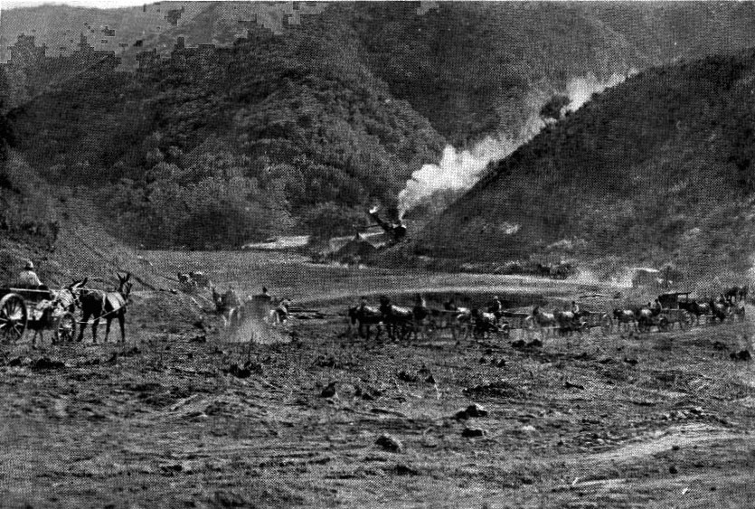
| (ca. 1918)^*^ - View showing the early stages of construction of the Chatsworth Reservoir using horses and carts. |
Historical Notes From the beginning of planning the Los Angeles Aqueduct, the Chatsworth Reservoir was included as the largest of the handful of sites to be used to hold surplus water during the winter months and for irrigation for farmers during the rest of the year. The area was eyed in 1911, and in 1913, negotiations were started with the owner of the property, daughter of B.F. Porter, for securing the land needed. It took four years for an agreement to be finalized, and work began in the summer of 1917. ^*^ |
 |
|
| (1918)^.^ – Construction workers pose in front steam shovel at the Chatsworth Reservoir dam site. |
 |
|
| (ca. 1919)* - View looking down toward the recently filled Chatsworth Reservoir. |
Historical Notes On April 9, 1918 William Mulholland turned the valve, and water first “officially” flowed into the Chatsworth Reservoir. (Some filling was done previously for testing). |
 |
|
| (ca. 1919)* – Closer view of the Chatsworth Reservoir. View appears to be facing northeast. |
Historical Notes After the initial filling, it took an additional year to complete construction of the largest dam; the reservoir was then filled completely in 1919. By 1916, a conduit had been built westerly along the foothill slopes of the north rim of the valley, aka the Chatsworth High Line. This conduit was already providing irrigation for farming in the north valley, and was extended three miles to feed the Chatsworth Reservoir. ^*^ |
 |
|
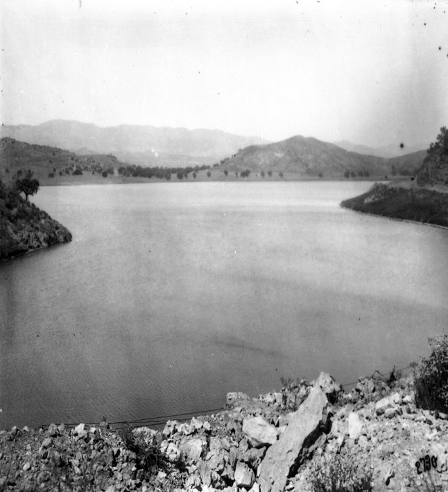
| (ca. 1925)* - The Chatsworth Reservoir in the Northwest San Fernando Valley was placed in service in 1919. |
Historical Notes Chatsworth Reservoir was placed in service in 1919 at a time when the San Fernando Valley was a sparsely populated agricultural area. The reservoir has two earthfill dams which provided an initial capacity of 7,400 acre-feet and a high water elevation of 884.3 feet.^# |
 |
|
| (ca. 1920s)^* - Aerial view northwest across Chatsworth Reservoir to the Simi Valley. The intersection of Roscoe and Topanga Blvds. can be seen in the center-left of the photo. |
Historical Notes For many years Chatsworth Reservoir served as the principal water storage facility in the western San Fernando Valley, serving the irrigation needs of agriculture. At various times during this period, improvements to the reservoir were constructed to increase its capability to provide the required water supply. The most significant improvement occurred during 1930 and 1931 when the dams were partially reconstructed to increase the high water level of the reservoir 5 feet to elevation 889.3 feet and the capacity to 9,840 acre-feet.^# |
 |
|
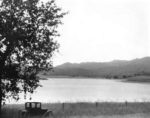
| (ca. 1930)* - Chatsworth Reservoir before enlargement. |
Historical Notes The most significant improvement to Chatsworth Reservoir occurred during 1930 and 1931 when the dams were partially reconstructed to increase the high water level of the reservoir 5 feet to elevation 889.3 feet and the capacity to 9,840 acre-feet.^# |
 |
|
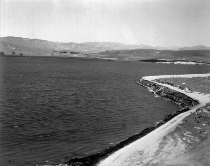
| (1930s)* - View showing the Chatsworth Reservoir and one of its two cement-lined dams with the Santa Susana Mountains seen in the background. |
Historical Notes The first draining of the reservoir took place in 1931 in order to renovate the two dams and for adding a 10-foot addition to their height. In this renovation, 300,000 cubic yards of compacted earth fill was added to the embankment and 85,000 cubic yards of loose rock fill. A total of 16,000 cubic yards of concrete was placed on the new facing, outlet tower, spillway, and cutoff walls of both dams. ^*^ |
 |
|
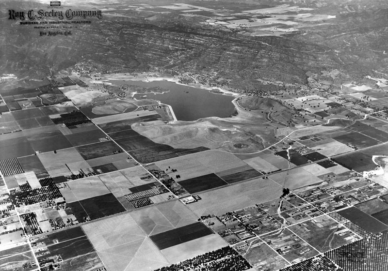
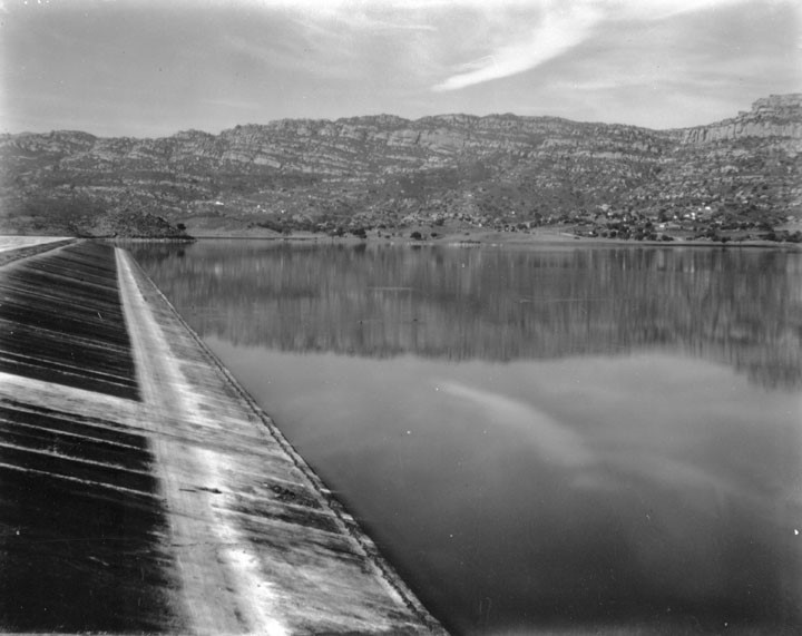
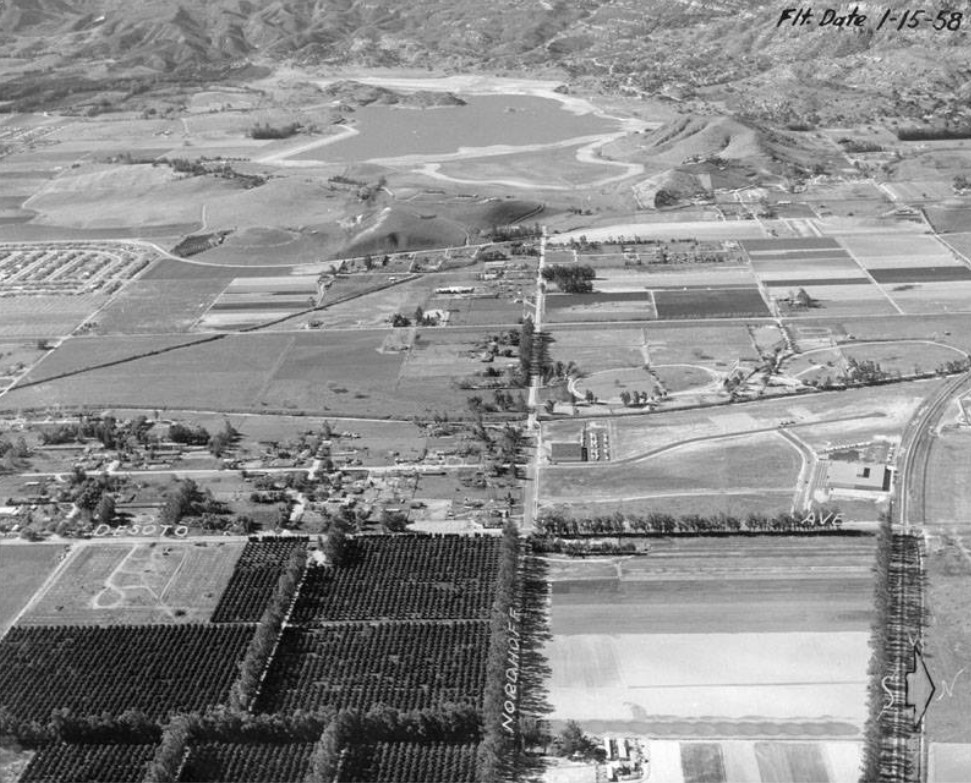
| (1958)* - Aerial view looking west on Nordhoff Street toward its intersection with Topanga Canyon Boulevard. The Southern Pacific tracks are on the right. The Chatsworth Reservoir, filled with water, is seen in the background. |
Historical Notes As the area served by Chatsworth Reservoir was subdivided and developed to meet the demands for increased housing, the character of the West San Fernando Valley changed from an agriculture to urban setting. This transition gradually changed the requirements for Chatsworth Reservoir and its storage was increasingly used to supply residential and domestic drinking water, emergency requirements and continued agriculture uses.^# |
 |
|
| (1960)^* - Aerial view looking north toward Ramo-Woodridge & Chatsworth residences. In the background is the Chatsworth Reservoir. The reservoir was placed out-of-service after the 1971 Sylmar Earthquake. |
Historical Notes After the Sylmar Earthquake of 1971 the Chatsworth Reservoir was placed out-of-service and permanently retired. Since then, 150 acres has been handed over to Rec. and Parks for recreational use. Another 30 acres has been converted to an ecology pond for the habitat of migratory birds.^* Click HERE to see more Early Views of the Chatsworth Reservoir. |
* * * * * |
Encino Reservoir (1921)
 |
|
| (ca. 1921)^* - Aerial view looking southwest showing the Santa Monica Mountains, Santa Monica Bay, and in the foreground on the Valley side of the mountains, Encino Reservoir. |
Historical Notes Encino Reservoir was constructed in 1921 to provide and store water for the fast growing San Fernando Valley. |
 |
|
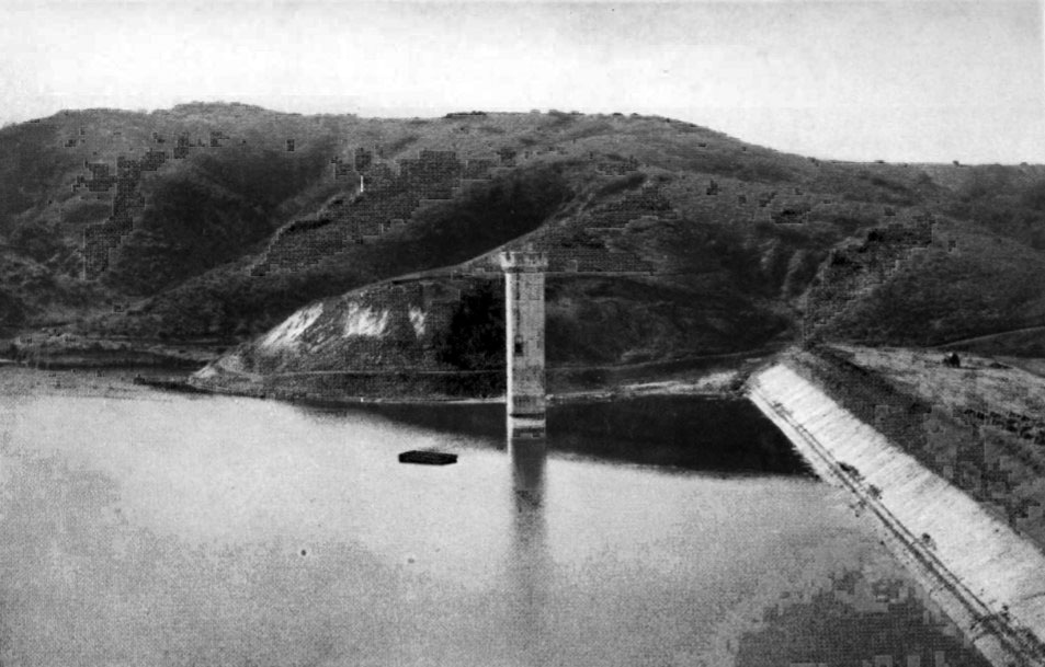
| (1921)^* – Encino Reservoir looking west showing completed tower. |
 |
|
| (ca. 1922)^* – Aerial view looking south toward Ventura Boulevard which runs horizontally near the center of the photo. In the upper right Encino Reservoir can be seen and about center-left is the Rancho Los Encinos. |
Historical Notes Encino (Spanish for evergreen or holm oak) is a hilly district of the San Fernando Valley. Specifically, it is located in the central portion of the southern San Fernando Valley and on the north slope of the Santa Monica Mountains. It derives its name from the Rancho Los Encinos (Ranch of the Evergreens), a parcel of land given to three Mission Indians by the Mexican government following its secularization of the California missions beginning in 1834. Rancho Encino was established in 1845. |
.jpg) |
|
| (1921)* – Aerial view looking north over the Santa Monica Mountains Showing the wide-open San Fernando Valley with Encino Reservoir in the foreground. |
 |
|
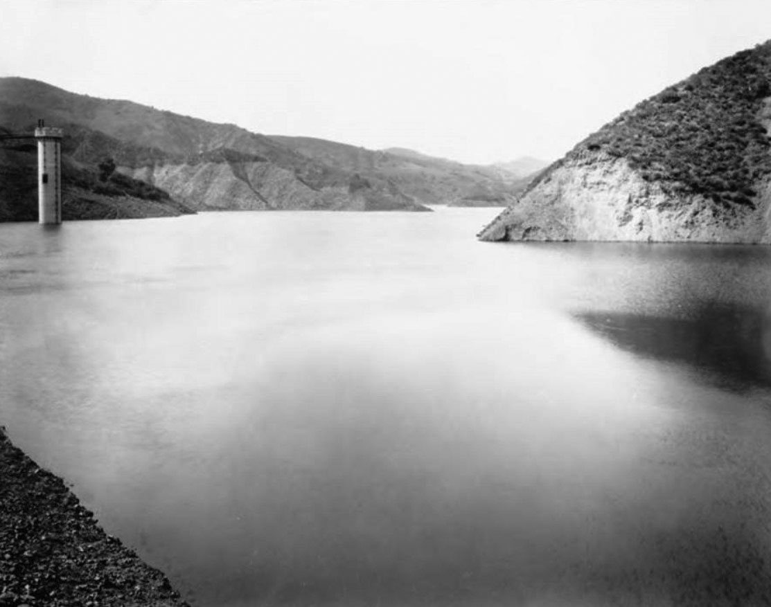
| (2002)^* - View of Encino Reservoir, looking north from Mulholland Drive. Nestled at the foot of the Santa Monica Mountains, the open reservoir is located opposite from an abandoned Nike Missile Base. Times Photo dated March 23, 2002. |
Historical Notes Encino Reservoir, which was originally constructed in 1921, is currently no longer in service but continues to hold water for fire and emergency purposes. |
* * * * * |
Stone Canyon Reservir (1924)
 |
|
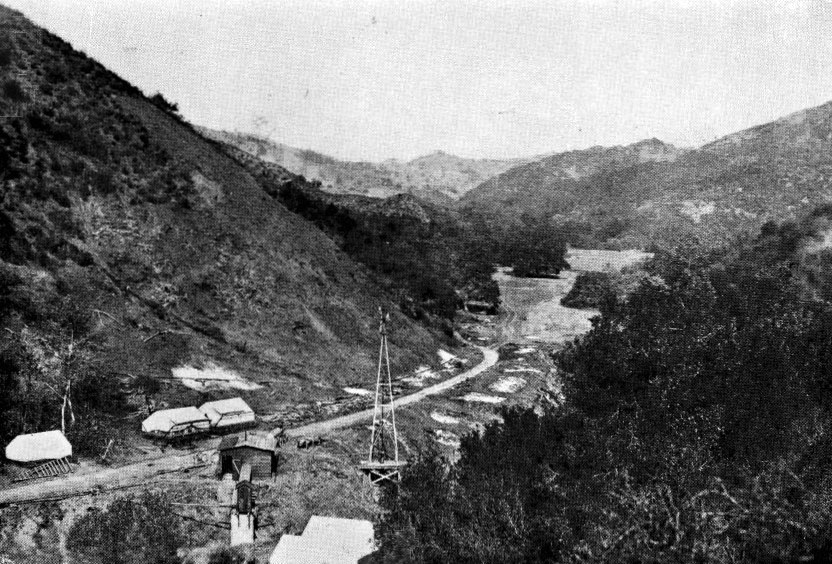
| (1919)^.^ – View showing the Stone Canyon Reservoir and Dam Site at start of construction. |
Historical Notes Construction work on the Stone Canyon tunnel started on October 1, 1919. The tunnel would bring the water into the new Stone Canyon Reservoir. |
 |
|
| (1920)^.^ – Horse-drawn wagons haul away dirt as a steam shovel (seen in background) digs in preparation for the Stone Canyon Dam. |
 |
|
| (1924)^.^ - View of the Stone Canyon Reservoir shortly after it was filled for the first time. |
Historical Notes The Stone Canyon Reservoir was built in 1924 by the Los Angeles Department of Water and Power, then named the Bureau of Water Works and Supply (BWWS). As with most other BWWS reservoirs of the time, it is of earth fill construction which was placed utilizing the hydraulic sluicing method. This method was pioneered and refined by William Mulholland. This reservoir had an original capacity of 8,000 acre⋅ft.^ |
 |
|
| (ca. 1930s)* – View showing the Stone Canyon Reservoir (lower reservoir) - Bledsoe Collection 1908-1933 |
 |
|
| (1941)^** – Aerial view looking Northwest across the Santa Monica Mountains to the San Fernando Valley showing the Stone Canyon Reservoir at center-left. |
 |
|
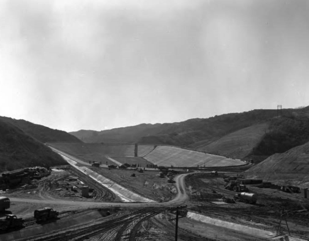
| (1950s)* - View showing construction work on the Upper Stone Canyon Reservoir. |
Historical Notes In the mid-1950s, the upstream part of the dam was rebuilt as a roller compacted backfill founded on rock, while the downstream part remained unchanged. The rehabilitation work was completed in 1956. |
 |
|
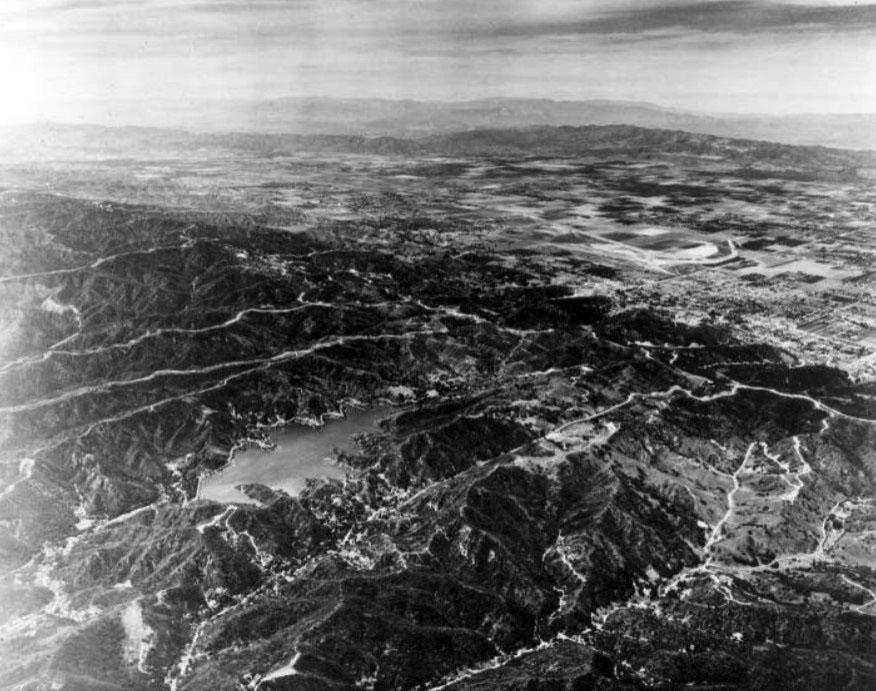
| (2010s)^.^ - View looking down towards the Upper and Lower Stone Canyon Reservoirs. |
Historical Notes The lower reservoir has already been decommissioned for regular use but with provision to address emergency situations with a small water treatment plant built to handle such a situation. In case of fire emergency it is planned that the lower reservoir which has enough storage could provide firefighting requirements.^ |
 |
|
| (2017)* – Panoramic view showing both the Upper and Lower Stone Canyon Reservoirs. |
Historical Notes A proposal to replace the existing Upper Stone Canyon Reservoir is under active consideration. The proposal is to replace the surface reservoir with three underground reservoirs beneath it to store 81 million US gallons of water. The underground structures are proposed to be covered initially with soil and then covered over with local vegetation. Hiking trails are also proposed to pass through the filled up area as a recreational activity to trek the canyon. The objective of this project is basically to follow the regulations set under the Federal Laws for uncovered reservoirs.^ |
* * * * * |
Sawtelle Reservoir (1924)
 |
|
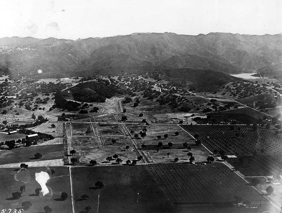
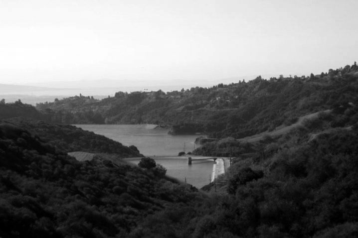
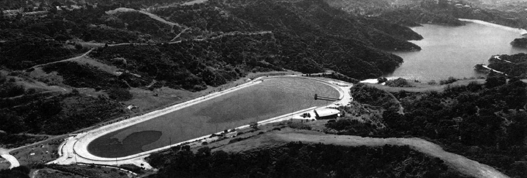
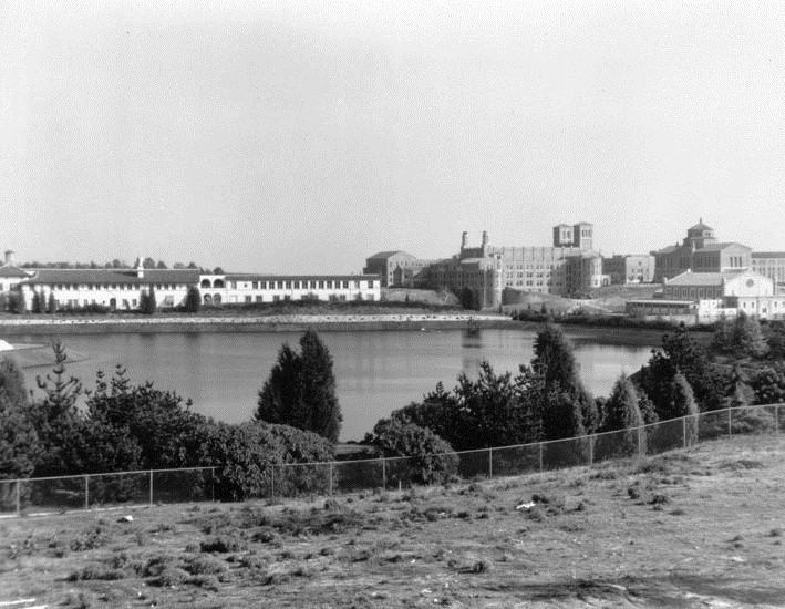
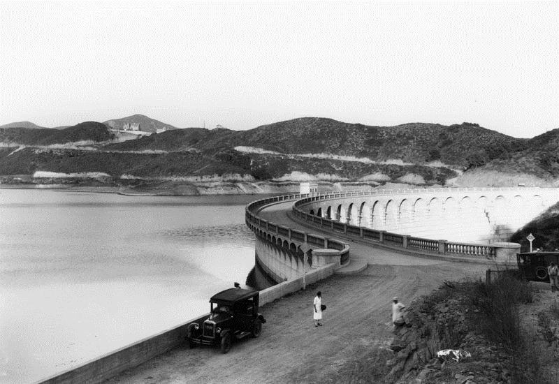
| (1929)* - View of the UCLA Westwood campus, at the time of its opening in 1929. View is looking southeast from the golf course of the Bel-Air Country Club. The body of water shown is the Sawtelle Pressure Break Reservoir. |
Historical Notes Installed in 1924, Sawtelle Reservoir was used to reduce the pressure of water coming from Stone Canyon Reservoir to West LA. |
 |
|
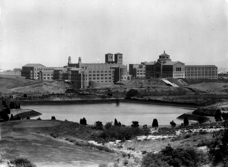
| (1930)* - A panoramic view of the UCLA Westwood campus, shortly after it opened in 1929. View is looking from the golf course of the Bel-Air Country Club. The body of water shown is the Sawtelle Pressure Break Resevoir. The twin towers of Royce Hall are seen in the middle of this photo. |
.jpg) |
|
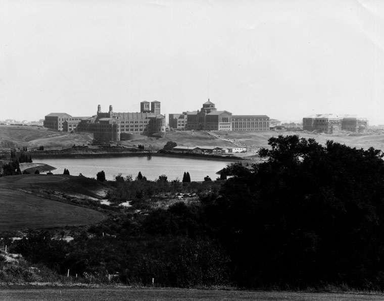
| (1931)#^ – Panoramic view of Bel-Air showing the UCLA campus and Westwood in center-right. The Sawtelle Pressure Break Resevoir is seen at center. The long two-story building behind it is Marymount High School. |
 |
| (ca. 1931)* - The Sawtelle Pressure Break Reservoir with Marymount High School on left and UCLA on the right. |
 |
|
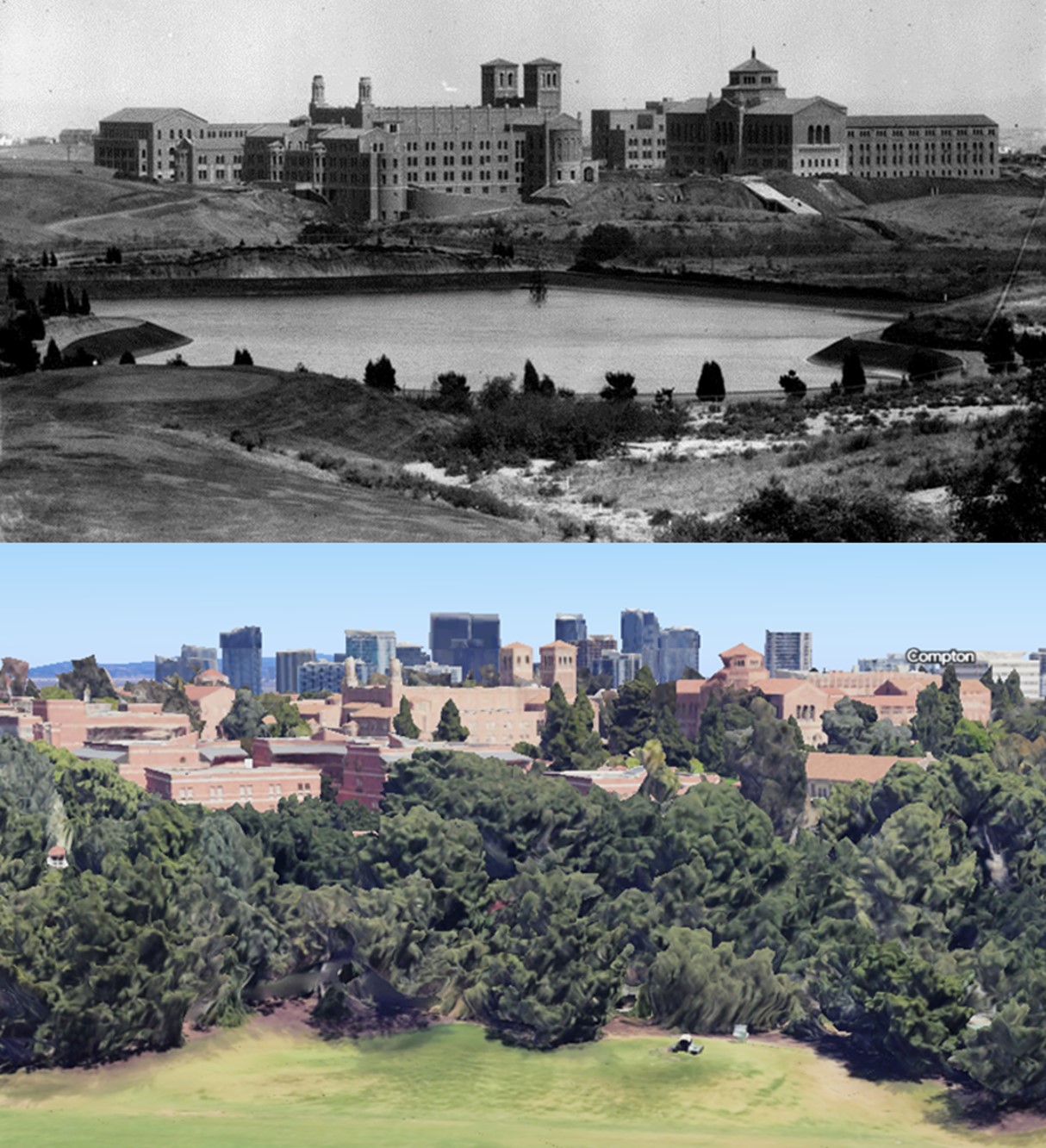
| (ca. 1931)* - The Sawtelle Pressure Break Reservoir was completed and put into service during the month of October (1924). The UCLA campus can be seen in the background. |
.jpg) |
|
| (ca. 1953)#* – Aerial view looking west showing the University of California Los Angeles campus with the Sawtelle Reservoir seen at center-right. |
Then and Now
 |
|
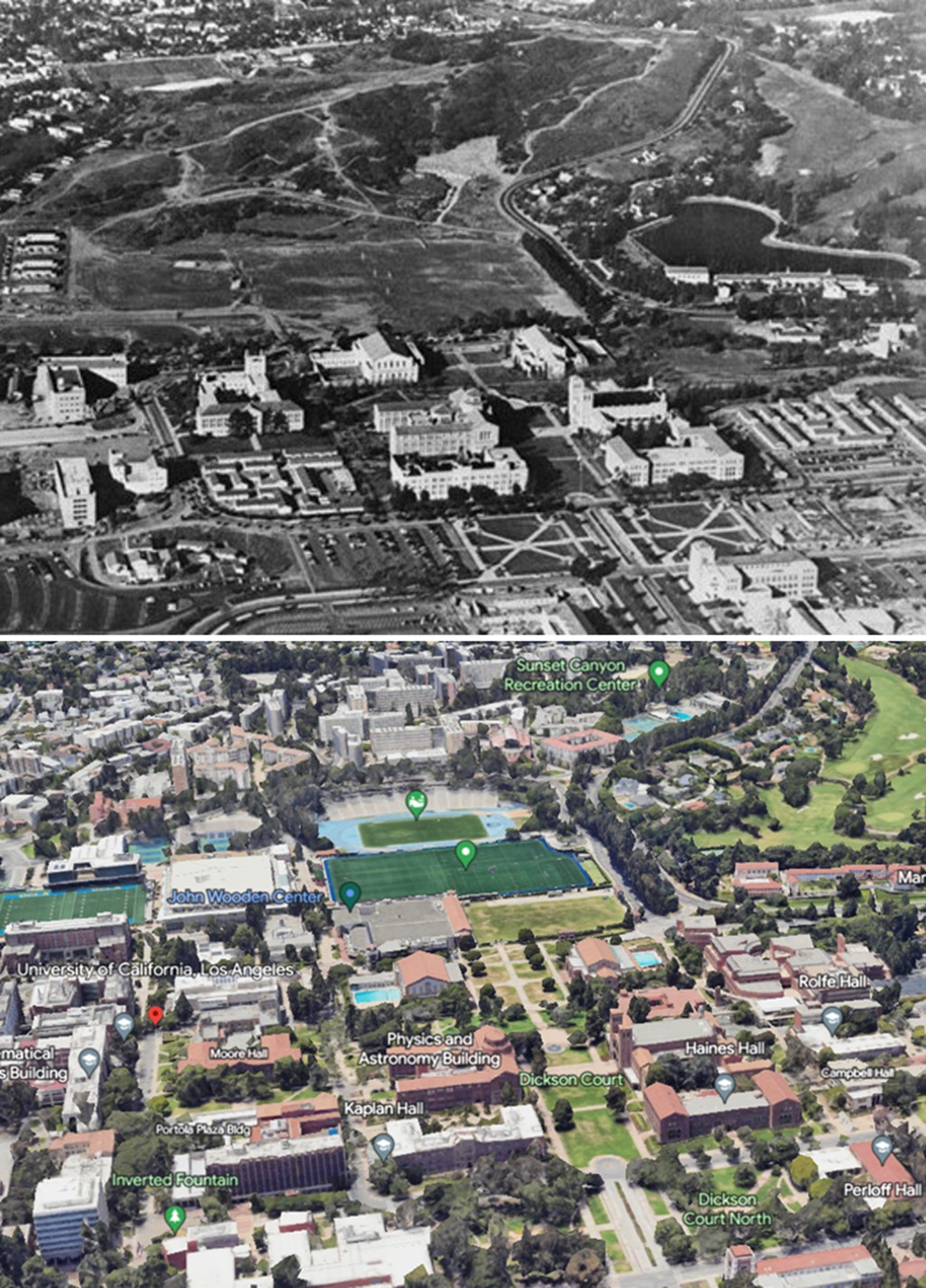
| (1953 vs 2022)*- Sawtelle Reservoir and UCLA Campus - Showing the Bel Air Golf Course where the Sawtelle Reservoir used to be. |
Historical Notes Sawtelle Reservoir was used to reduce the pressure of water coming from Stone Canyon Reservoir to West LA and was replaced by a pressure regulating station in the mid 1980's |
Then and Now
 |
|
| (1929 vs 2022)* - Sawtelle Reservoir - Then and Now |
Click HERE to see more in Early Views of UCLA |
* * * * * |
Mulholland Dam and Hollywood Reservoir (1925)
 |
|
| (1925)* - Hollywood Reservoir and Mulholland Dam. Photo shows front of dam wall. The Hollywoodland sign is dimly seen high in the hills. |
 |
|
| (1928)* - View of Mulholland Dam and Hollywood Reservoir (also known as Lake Hollywood) both designed and built by engineer William Mulholland, for which the Dam is named after. |
Historical Notes Construction of the Mulholland Dam and Hollywood Reservoir began on August 1923, and they were completed just one year later, in December 1924. The man-made reservoir, which held more than 2.5 billion gallons of water, was filled in 1925; it was part of the Owens River Aqueduct system (LA Aqueduct) and provided Los Angeles with most of its drinking water.* Note: The reservoir is no longer in use as shown above. |
 |
|
| (ca. 1928)* - The Mulholland Dam is visible in the upper center of the photo behind the Yucca Vine Tower in Hollywood. |
Click HERE to see more of the Mulholland Dam and Hollywood Reservoir |
 |
|
| (1941)* - Landscaping completed at the Mulholland Dam and Hollywood Reservoir. After the 1928 St. Francis disaster, the Mulholland Dam was reinforced with tons of earth on the downstream side as a precaution. |
Historical Notes In 1989, the Mulholland Dam and Lake Hollywood Reservoir were designated LA Historic-Cultural Monument No. 421 (Click HERE to see complete listing). |
* * * * * |
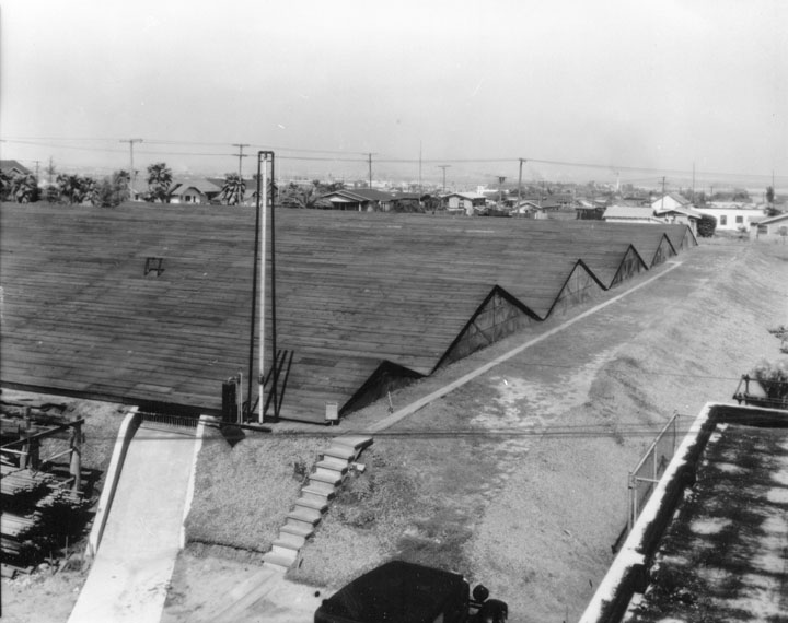
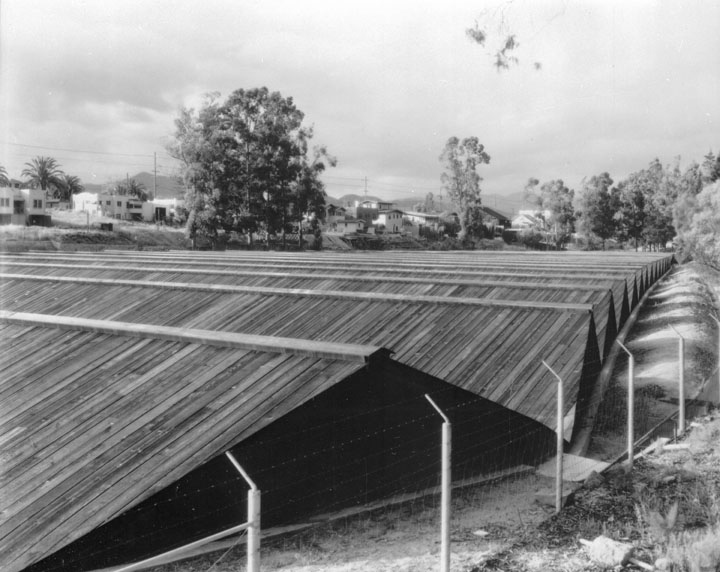
Maclay Reservoir (1929)
 |
 |
| View 1 (1929)** - Maclay Reservoir covered with wood planks. | View 2 (1929)** - The reservoir was built as part of the San Fernando/Owens Aqueduct. |
 |
|
| (1933)* - Maclay Pumping Plant |
LADWP Historic Archive
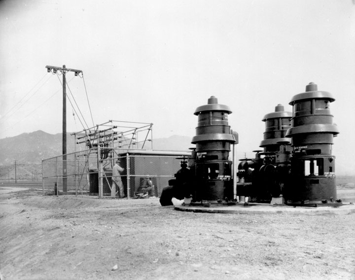
Dependability of water service to the area in the western section of San Fernando Valley served by the Maclay reservoir is strengthened further by the recent installation of a battery of pumps at Upper San Fernando reservoir.
Largest of their kind in the local water system, the pumps are described by S. M. Dunn, assistant to Fred J. Fisher, engineer in charge of pumping plants and reservoirs, as being 12-inch, 250 horsepower, and deep well turbine type. They are set in a common pit approximately 40 feet deep, and have a capacity of 15 second feet against a head of 325 feet.
The pumping plant is located just below the San Fernando power plant along the penstock by-pass line. In the event of a protracted shutdown of the main aqueduct, water from the reservoir would be pumped back through the penstock to its connecting point with the branch line supplying Maclay reservoir.
Paul J. Stoakin, in charge of all electric pumping plants under Fischer, said that the pumps are kept primed when the reservoir level is down by a vacuum pump located in the switch house.
Although the plant is at the edge of Upper San Fernando reservoir, it will be known as Maclay pumping plant because its function is to supply Maclay reservoir when necessary. Fred Martin, operator of nearby Mission Wells pumping plant, will be in charge of the new plant also.*^
* * * * * |
Baldwin Hills Reservoir (1951)
 |
|
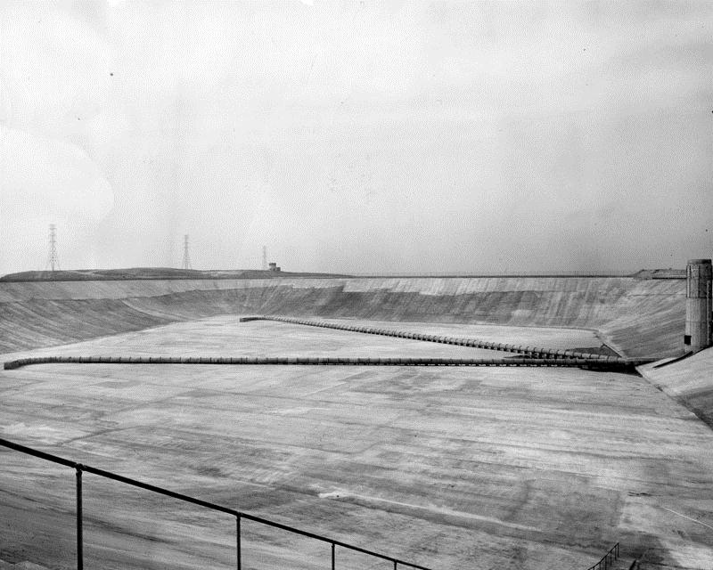
| (1951)* - A view of the floor of the Baldwin Hills Reservoir in the final stages of construction in 1951. |
Historical Notes On December 14, 1963, the Baldwin Hills Reservoir dam breached, releasing 250 million gallons of water onto the surrounding neighborhood. 277 homes were destroyed and 5 lives were lost. Vigorous rescue efforts averted a greater loss of life. The reservoir is now part of Kenneth Hahn State Recreation Area.^ |
* * * * * |
Water Tank Reservoirs
 |
|
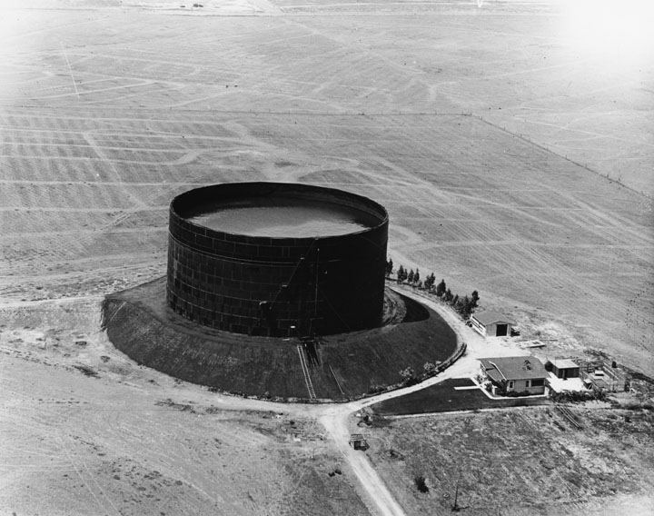
| (1924)^* - View of a water tank reservoir at Western Ave. & 199th Street. It is located on slightly raised ground with open fields behind it. On the lower right are 3 or 4 buildings. |
.jpg) |
|
| (1924)^* - Aerial view of the large water tank reservoir at Western Ave. & 199th Street. There are still construction materials on the ground below and a portion of a building to the left. |
 |
|
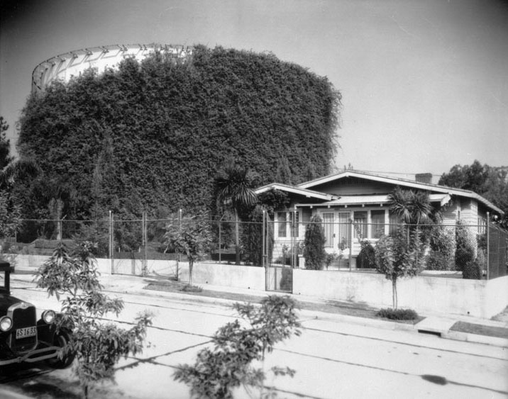
| (1932)* - Water tank covered with vine growth in Department's beautification plan. |
LADWP Historic Archive
November 1932 – “That such an unprepossessing and unwieldy a thing as a steel reservoir is not esthetically impossible or beyond the reach of beautification programs is definitely proved in the case of one of those of the Los Angeles city water system on Finley Avenue a block or so east of Hillhurst in East Hollywood,” says a writer in a recent issue of The Sunday Times Farm and Garden section.
The writer observes that although the grounds around the structure have been ably landscaped with an eye to beautification, it is the reservoir itself which attracts attention because of the clever way in which it had been handled. The great steel tank has been virtually hidden beneath a covering of Tecoma australis, the wonga-wonga vine of Australia.
The growth is supported for the entire height of the reservoir by wire netting. Even in severe wind storms the mass of green has clung tenaciously to the foundation. Much progress has been shown in the vine growth since planting about four years ago. L. A. Ghiotto is caretaker of the grounds. Harry L. Murietta is in charge of all landscaping around reservoirs.
Nationwide attention has been given to the scheme of beautification undertaken by both the Bureau of Water Works and Supply and the Bureau of Power and Light. Power Bureau distribution stations are objects of architectural beauty. They are creditable additions to any section of the City. The grounds surrounding these structures are planted to shrubs and plants that blend harmoniously with the building. C. W. Fox is in charge of this work.
In many cases the method of landscaping around pumping plants and reservoirs of the Water Bureau and Distribution and Receiving Stations of the Power Bureau have inspired great effort toward improvements in surroundings of privately-owned lots and homes sites.*^
* * * * * |
History of Water and Electricity in Los Angeles
More Historical Early Views
Newest Additions
Early LA Buildings and City Views
* * * * * |
References and Credits
* DWP - LA Public Library Image Archive
^*LA Public Library Image Archive
**CSUN Oviatt Library Digital Collection
^ Baldwin Hills Reservoir - Wikipedia
#^Huntington Digital Library Archive
*#Jewish Museum of the American West: Herman Silver
^^San Fernando Valley Relics - Facebook.com: Van Norman Reservoir
+#LA Times Framework: Know Your City
++Silver Lake Reservoirs Conservatory
*** Theeastsiderla.com: Angelino Heights Oil Boom
^.^Claremont Colleges Digital Library
^^^KCET: How Mulholland Made Ivanhoe Canyon Into Silver Lake
**^ LA Magazine: How Ivanhoe Canyon Became Silver Lake
^**California State University, Dominguez Hills Photograph Collection
**# Historicechopark.org: Echo Park Lake
*## Facebook.com: Classic Hollywood/LA/SFV
^## California State Library Image Archive
^*^ Facebook.com: West San Fernando Valley Then And Now
*^* Wikipedia: Lower Van Norman Dam; Lincoln Park (Eastlake Park); MacArthur Park (Westlake Park)
< Back