Early Views of Hollywood (1920 +)
 |
|
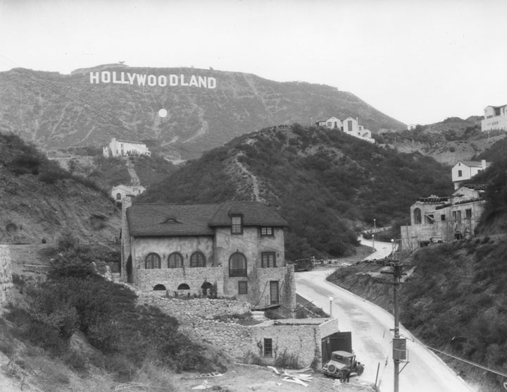
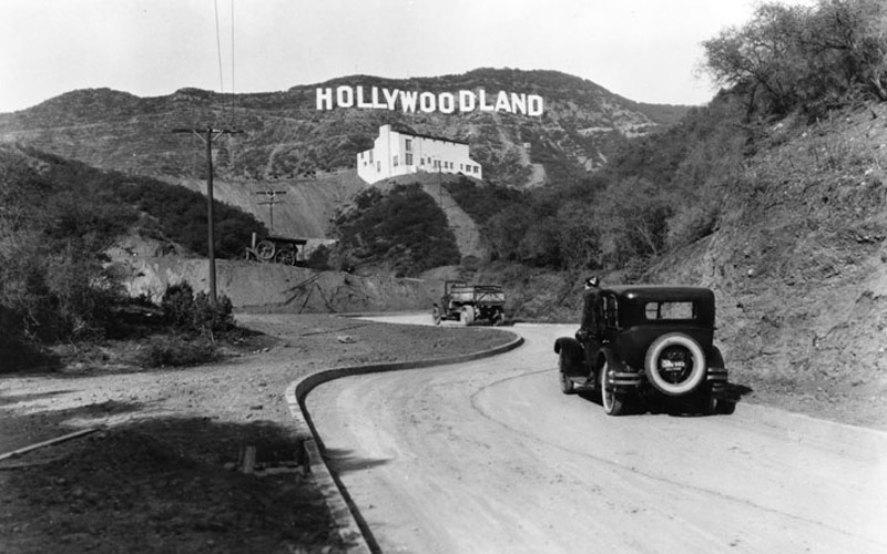
| (ca. 1920s)* - The HOLLYWOODLAND sign was erected in 1923 to advertise a new housing development in the hills above the Hollywood district of Los Angeles. In 1949 the Hollywood Chamber of Commerce contracted to repair and rebuild the sign. The contract stipulated that “LAND” be removed to reflect the district, not the housing development. |
Historical Notes Real estate developers Woodruff and Shoults called their development "Hollywoodland" and advertised it as a "superb environment without excessive cost on the Hollywood side of the hills". They contracted the Crescent Sign Company to erect thirteen letters on the hillside, each facing south. Each letter of the sign was 30 feet wide and 50 feet high, and the whole sign was studded with some 4,000 light bulbs. The sign would flash in segments; "HOLLY," "WOOD," and "LAND" would light up individually, before lighting up entirely. Below the Hollywoodland Sign was a searchlight to attract more attention.* |
 |
|
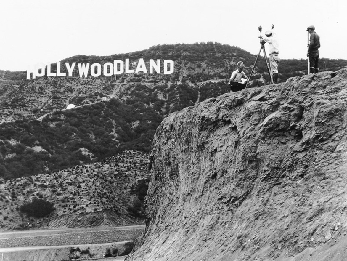
| (1923)* - Hillsides separated by a road. Three surveyors focus on the Hollywoodland Sign on the opposite hill. |
Historical Notes The sign was officially dedicated on July 13, 1923. It was not intended to be permanent. Restoration company Bay Cal Painting says on its website that the expected life was to be about a year and a half, but after the rise of the American cinema in Los Angeles during the Golden Age of Hollywood, the sign became an internationally recognized symbol, and was left there. Some Hollywood history enthusiasts hope to someday see the sign reverted to its original state.* |
 |
|
| (1923)^ - About a dozen men cheering for the camera in what seems to be the completion of an early phase of the new housing development project. At the same time, construction crews appear to still be working. |
 |
|
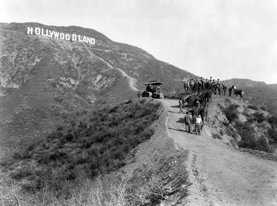
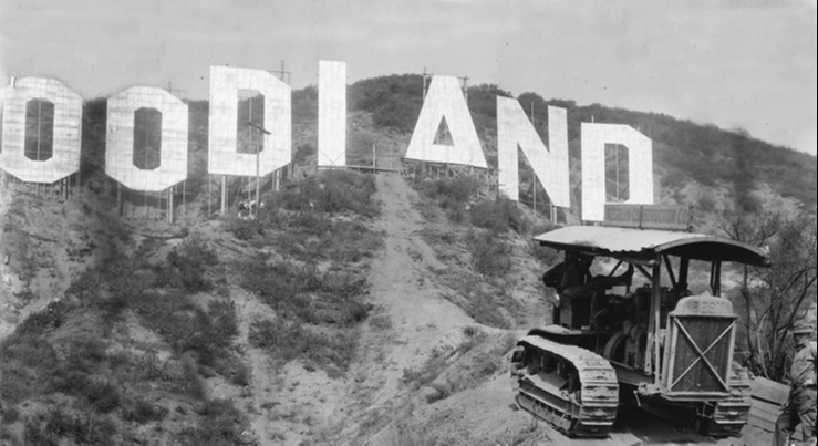
| (1923)*# - Close-up view of a tractor in front of the Hollywoodland Sign. Each letter of the sign is 30 feet wide and 50 feet high. |
 |
|
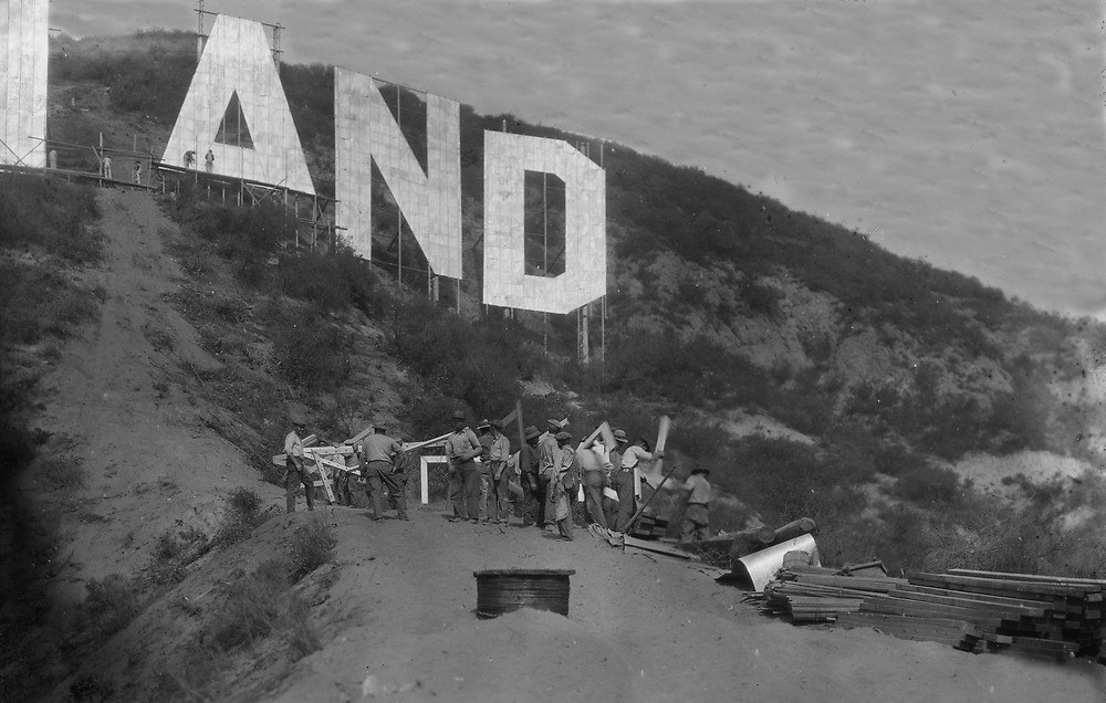
| (1923)^ - Close-up view showing construction workers assembling the last pieces of wood that would complete the Hollywoodland Sign. |
 |
|
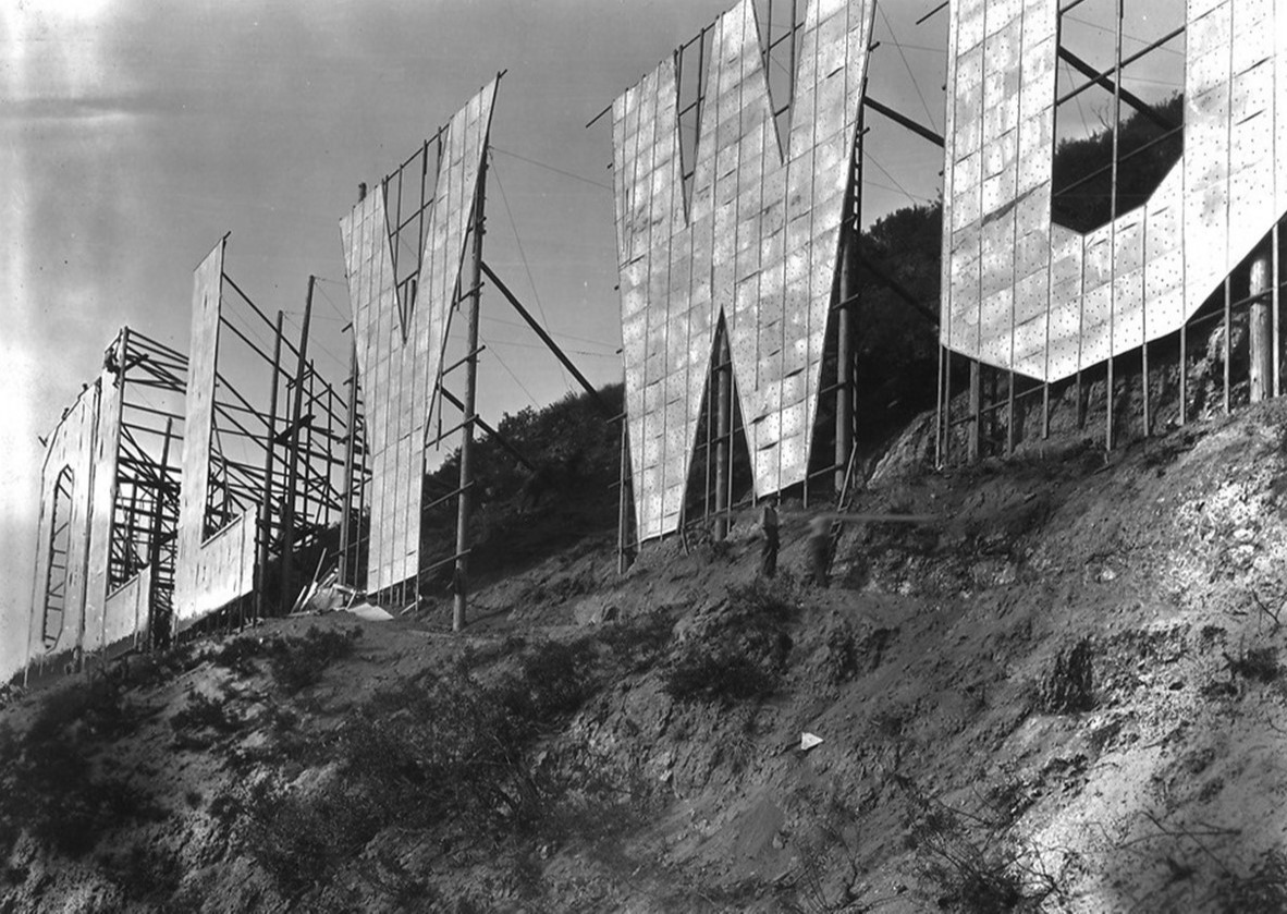
| (1923)* - Close-up view of the Hollywoodland Sign showing the supporting structure behind the 45-feet-tall upper case letters. |
 |
|
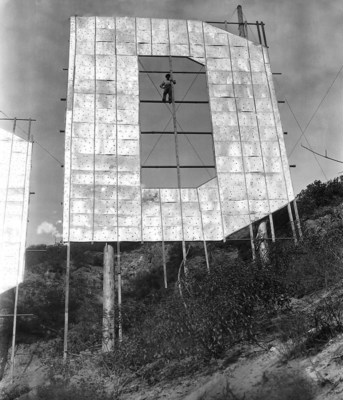
| (1923)* - A construction worker stands on the brackets behing the letter 'D'. |
 |
|
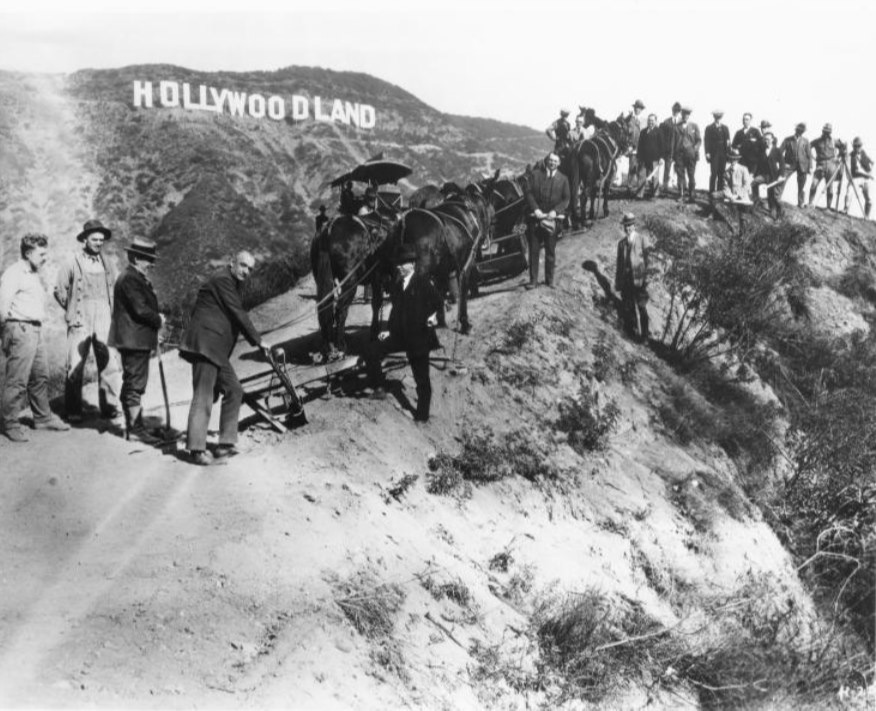
| (1923)* - Men in suits on small hilltop wave their hats as construction workers climb the dirt road behind horse-drawn ploughs. |
 |
|
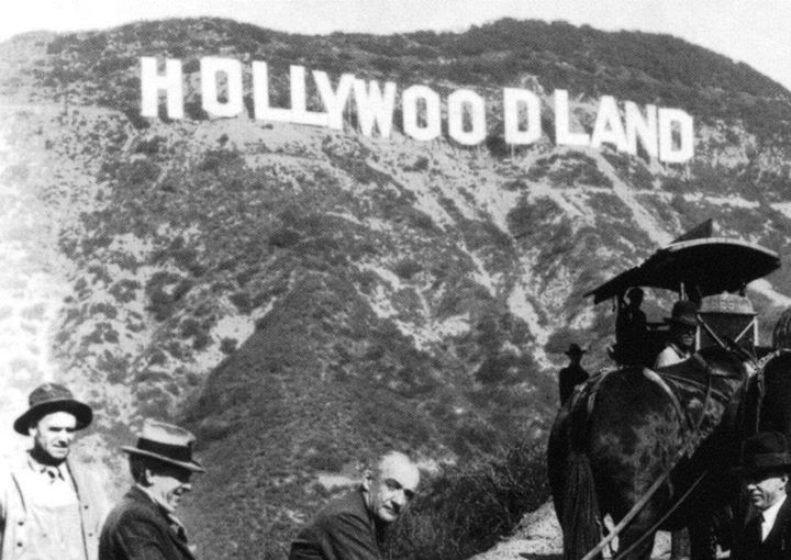
| (1923)* - Close-up view showing men in suits posing for the camera behind a horse-drawn plough as construction workers and surveyors stand in on the hillside with the Hollywoodland Sign in the background. |
 |
|
| (1923)* - Closer view of the Hollywoodland Sign behind the construction workers and the men in suits. |
Historical Notes Ironically, the real estate venture initially failed but they never got around to taking the sign down and it ended up becoming one of the most iconic signs in history. |
 |
|
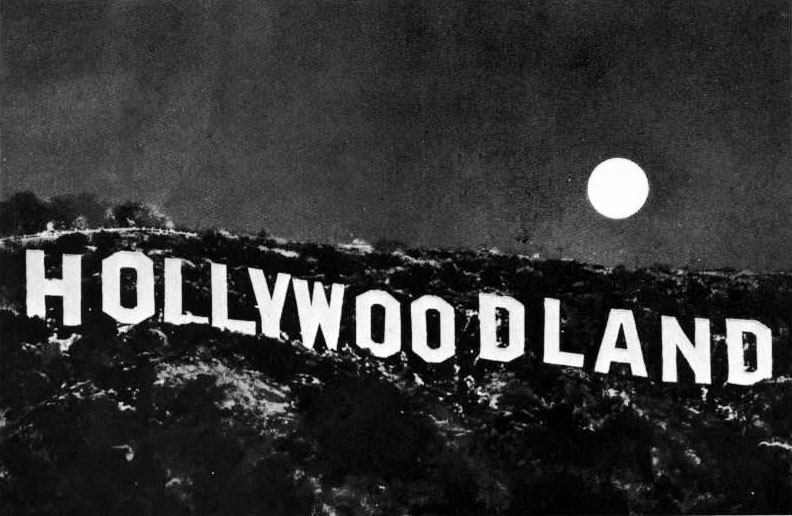
| (n.d.)^ – Night view showing a full moon behind the HOLLYWOODLAND sign. |
 |
|
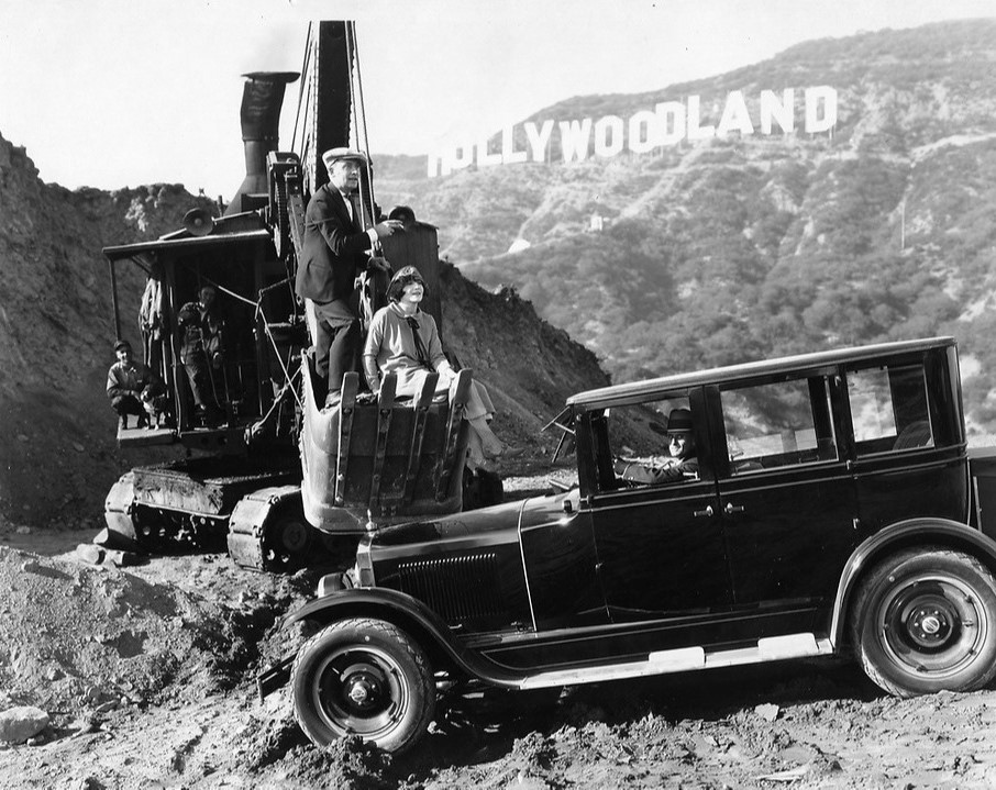
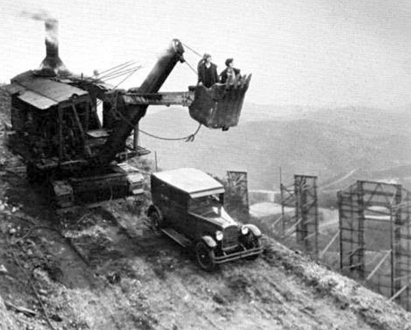
| (1923)* – Publicity shot showing several people on a steam shovel and early model car with the Hollywoodland Sign in the background. |
 |
|
| (1923)* – Another publicity shot showing a pair of Mack Sennett Bathing Beauties in a steam shovel posing for the cameras right behind the Hollywoodland Sign. |
The 'White Dot' Mystery
 |
|
| (1924)* - View showing one of the first homes built in the Hollywood Hills located at 6182 Mulholland with the Hollywoodland Sign in the background. Note the large WHITE DOT directly below the sign. Over the years there has been a lot of speculation of what the White Dot is (see below): |
|
THE WHITE DOT - Contrary to what has been written before, the white dot, located below the Hollywoodland sign was not installed as an “eye catcher.” How that story got started is anyone’s guess. But it’s absurd! Why would an eye catcher be installed when there is a 543 foot long, 45 foot high white sign just above the dot? The real story is a bit more complicated. In 1920-21, the US Chamber of Commerce produced maps illustrating business conditions in areas of the country. Those shaded black were poor, white with black stripes (grey) were fair and white was good. Los Angeles was a “white spot” in a sea of black and grey on the map in the early 1920s. Los Angeles Times publisher, Harry Chandler adopted the catchprase, “White Spot Of America” as being a city free of crime, corruption and communism. Chandler, who was vehemently anti-union, was an influential proponent of developing a strong economic base in Los Angeles. It wasn’t long before the phrase “keep the white spot white” was being commonly used. The term “white spot” typically referred to LA”s relative prosperity and low unemployment, and was not intended to have racial overtones. So, for Los Angeles, the term, “keep the white spot white” meant keep L.A. prosperous. In late 1924, in order to demonstrate support for the “keep the white spot white”, campaign, Hollywoodland erected a 35 foot diameter “white dot” on the hillside, several feet below the Hollywoodland sign. The cost to erect the dot was $936.16. Contrary to popular belief, the white dot was not illuminated.* |
 |
|
| (1930s)^ - "Hollywoodland" Sign with four homes in foreground set along a winding road. Also seen here is the large WHITE DOT under the sign. |
 |
|
| (1935)* – View showing the same home 11 years later. Still looks like a dirt road but now with curbs. |
 |
|
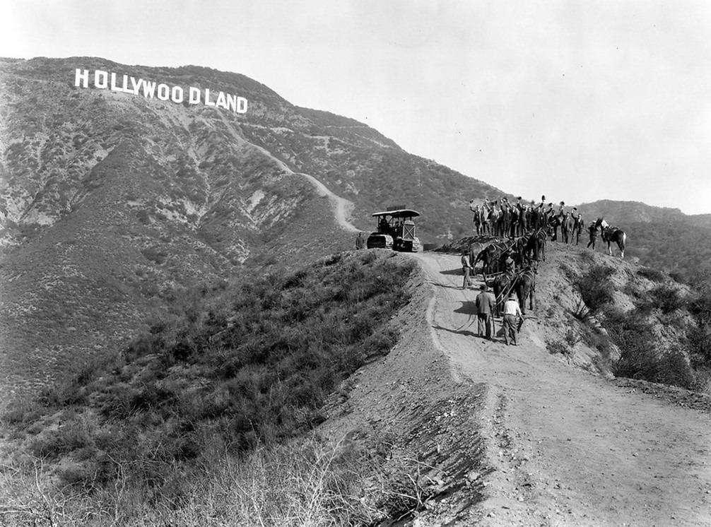
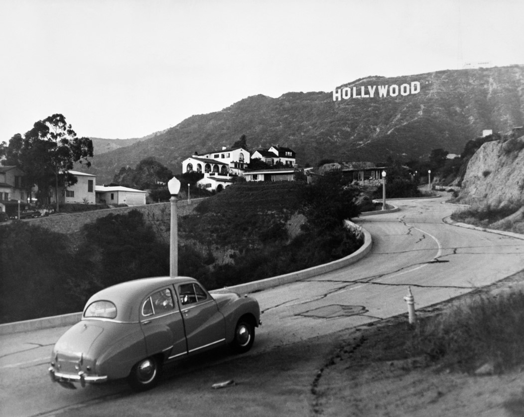
| (ca. 1950)** – View looking up Deronda Drive showing the Hollywood Sign in the background. The HOLLYWOODLAND sign was shortened to HOLLYWOOD in 1949. |
Historical Notes In 1949, the Hollywood Chamber of Commerce began a contract with the City of Los Angeles Parks Department to repair and rebuild the sign. The contract stipulated that "LAND" be removed to spell "Hollywood" and reflect the district, not the "Hollywoodland" housing development. The Parks Department dictated that all subsequent illumination would be at the Chamber's expense, so the Chamber opted not to replace the lightbulbs.^ |
Housing Development in the Hollywood Hills
 |
|
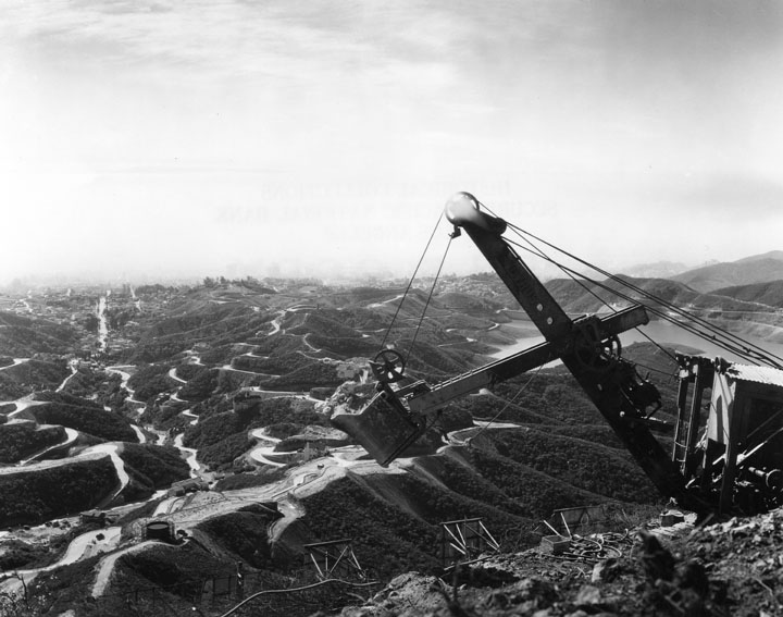
| (ca. 1929)* - View showing a steam shovel on a hillside overlooking the Hollywood Hills and newly carved winding roads. In the foreground can be seen the top of the brackets that support the Hollywoodland Sign. The body of water on the right, partially hidden by the steam shovel, is the Hollywood Reservoir (completed in 1925). Click HERE to see more in Early Views of the Mulholland Dam and Hollywood Reservoir. |
 |
|
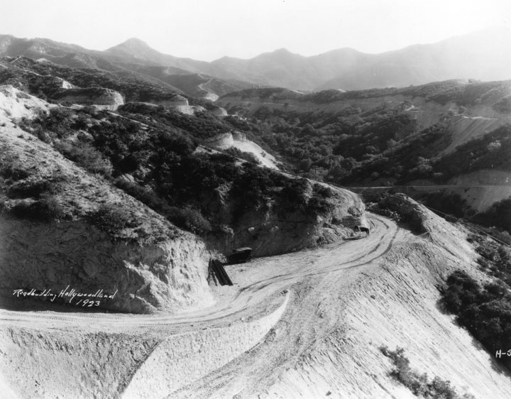
| (1923)* - View of the hills where roads are being graded for future homes in Hollywoodland. This will be Belden and Flagmoor Streets (looking north east). |
 |
|
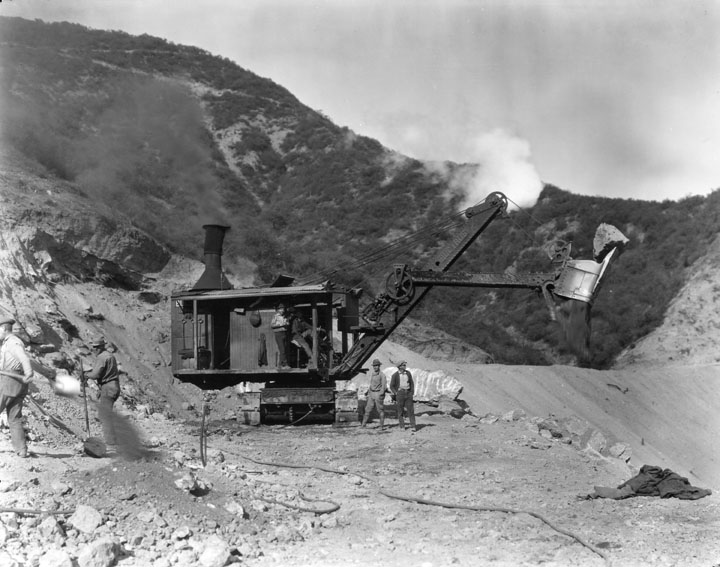
| (1924)* - Two men in the cab and 2 outside watch as a steam shovel picks up dirt and a very large stone while clearing roads in the Hollywoodland area. |
 |
|
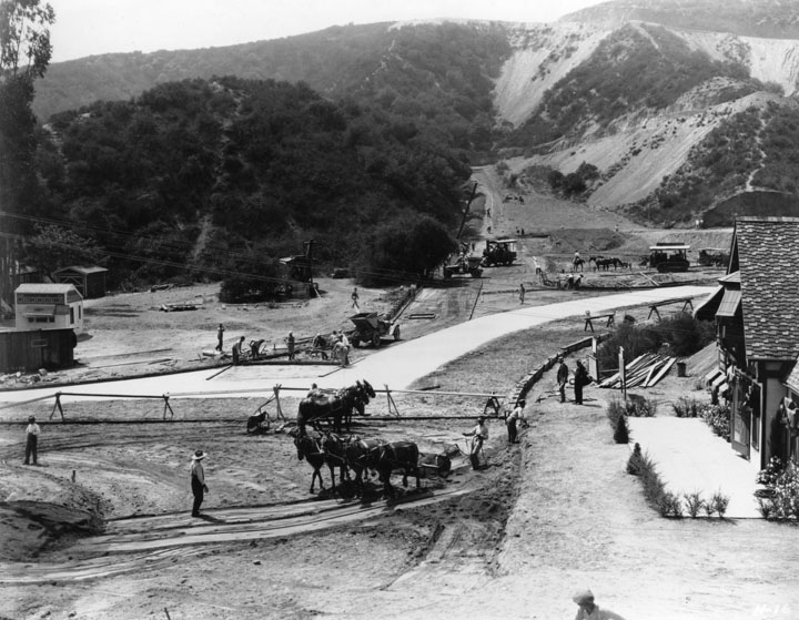
| (ca. 1924)* - Horses as well as heavy equipment being used to grade the land in the Hollywoodland real estate development, while workers do preparation for pouring concrete. A sign on a temporary building says "Western Construction Co." |
 |
|
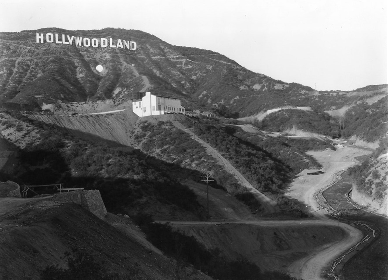
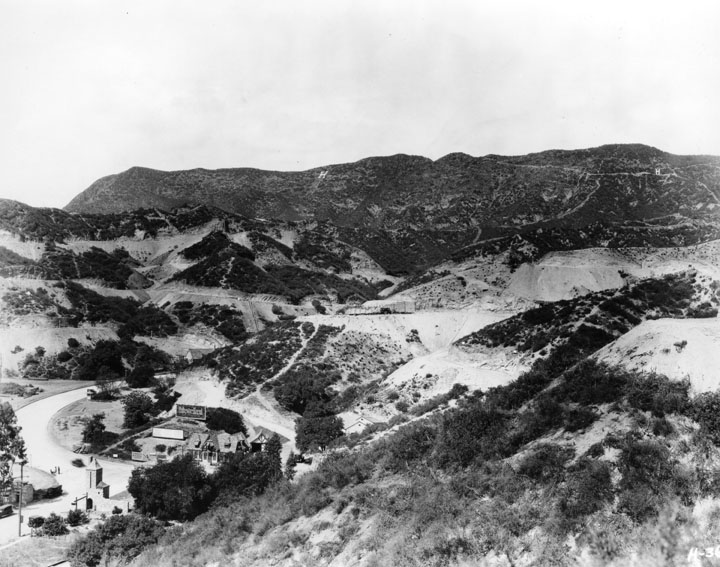
| (ca. 1920s)* - An early view of the Hollywoodland sales office seen from the hill above it. In the upper background can be seen what appears to be the first letter 'H" of the HOLLYWOODLAND. It turns out, though, that it is a stand alone "H" not connected with the HOLLYWOODLAND sign. |
 |
|
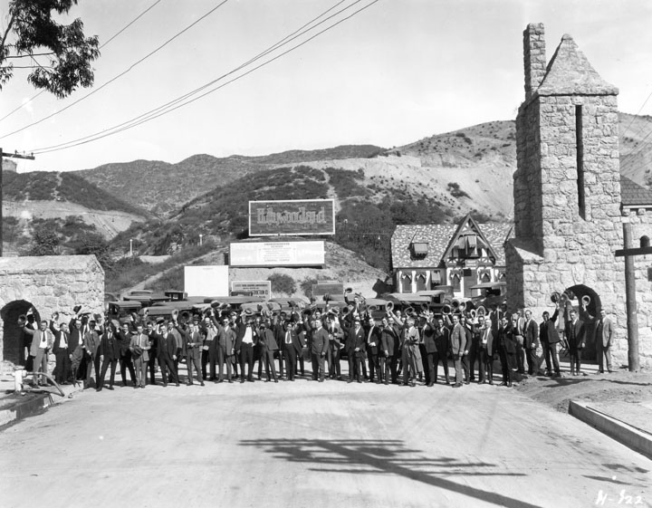
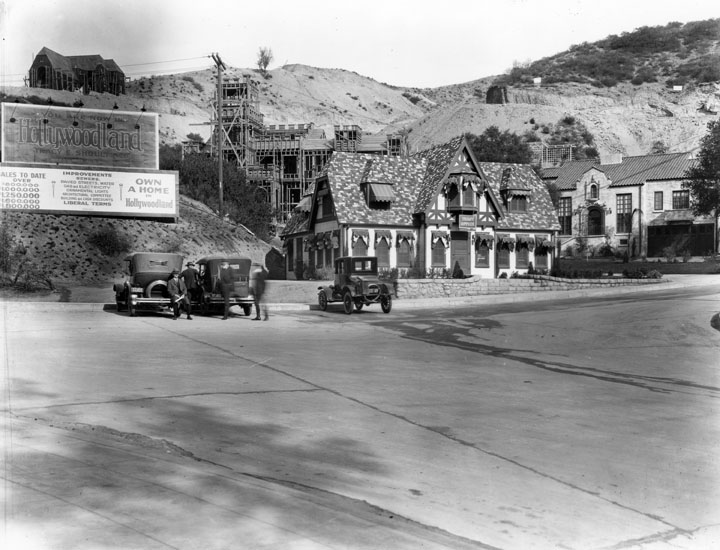
| (ca. 1924)* - The construction sign in back reads "You are now in Hollywoodland, Tray E. Shoults Co.". In the street in front of the Tract Office and other buildings approx. 70 men in a line 2 to 3 rows deep stand at the gates of Beachwood Drive. |
Historical Notes Albert Beach paved the way to the Hollywood Hills in 1911 and named Beachwood Drive after himself. Beach owned and developed much of the area in and around Beachwood Canyon in such tracts as Kentland Square and Beachwood Park. |
 |
|
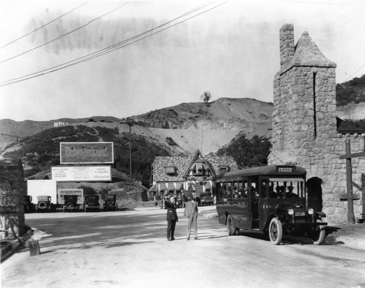
| (ca. 1924)* - A bus full of people is stopped in the street outside the real estate sales offices. Two men in the street point to something in the distance for the benefit of the bus. Electric busses like this one were promised for Beachwood Drive in Hollywoodland as soon as the street was paved. Part of the HOLLYWOODLAND Sign can be seen in the background. |
 |
|
| (ca. 1924)* - Three cars are parked in the street in front of a sign for Hollywoodland sales. To the right is the tract office building. Behind that another building is under construction. Another at the top of the hill looks nearly finished. |
 |
|
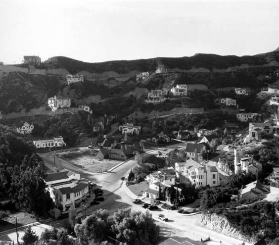
| (1928)##^* - View showing how in just a few years the Beachwood Drive area began to grow. |
 |
|
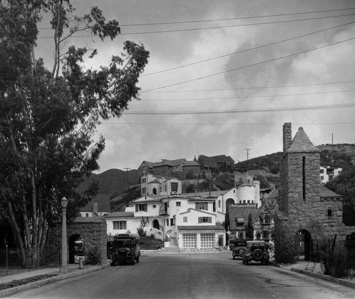
| (ca. 1928)#**# - Homes sparsely dot the hillside of early Hollywoodland. The gates of Beachwood Drive are seen at lower-left. |
Then and Now
 |
|
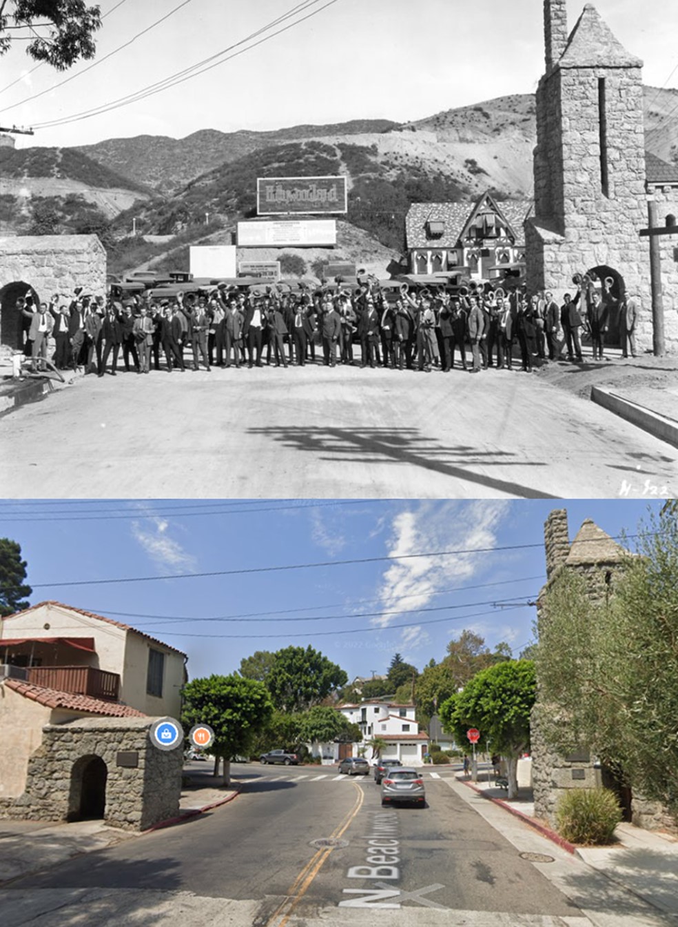
| (1924 vs. 2022) – looking north on Beachwood Drive at the entrance to the new 1923 tract development named Hollywoodland for which a very large HOLLYWOODLAND sign would go up (out of view). Ironically, the real estate venture initially failed but they never got around to taking the sign down and it ended up becoming one of the most iconic signs in history. |
* * * * * |
Balcony with a View
 |
|
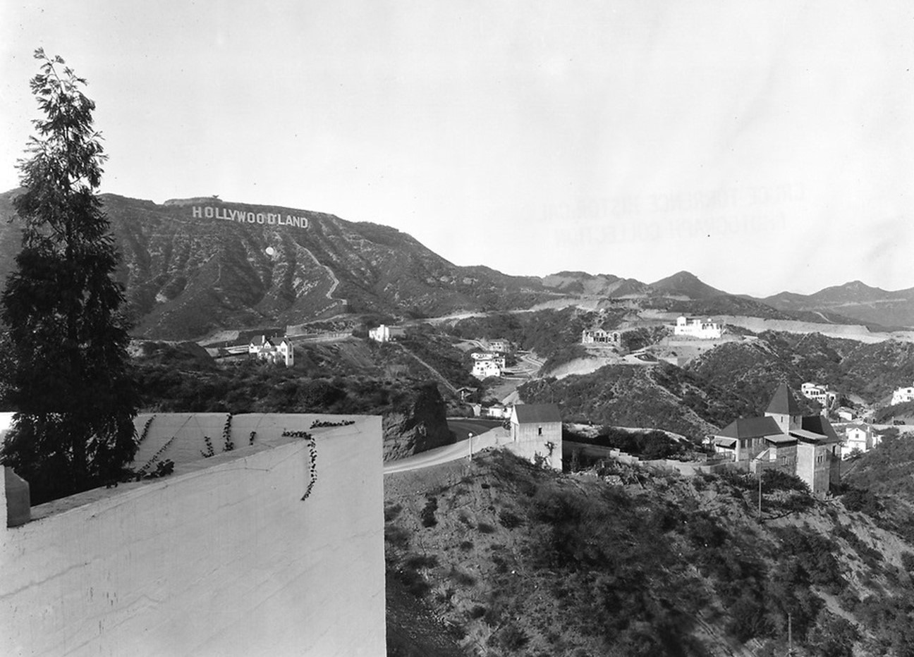
| (ca 1928)* – Balcony with a view showing new development under the Hollywoodland Sign. Note the white dot under the sign. There is a fascinating explanation to why it was there (see below). |
Historical Notes THE WHITE DOT - Contrary to what has been written before, the white dot, located below the Hollywoodland sign was not installed as an “eye catcher.” How that story got started is anyone’s guess. But it’s absurd! Why would an eye catcher be installed when there is a 543 foot long, 45 foot high white sign just above the dot? The real story is a bit more complicated. In 1920-21, the US Chamber of Commerce produced maps illustrating business conditions in areas of the country. Those shaded black were poor, white with black stripes (grey) were fair and white was good. Los Angeles was a “white spot” in a sea of black and grey on the map in the early 1920s. Los Angeles Times publisher, Harry Chandler adopted the catchprase, “White Spot Of America” as being a city free of crime, corruption and communism. Chandler, who was vehemently anti-union, was an influential proponent of developing a strong economic base in Los Angeles. It wasn’t long before the phrase “keep the white spot white” was being commonly used. The term “white spot” typically referred to LA”s relative prosperity and low unemployment, and was not intended to have racial overtones. So, for Los Angeles, the term, “keep the white spot white” meant keep L.A. prosperous. In late 1924, in order to demonstrate support for the “keep the white spot white”, campaign, Hollywoodland erected a 35 foot diameter “white dot” on the hillside, several feet below the Hollywoodland sign. The cost to erect the dot was $936.16. Contrary to popular belief, the white dot was not illuminated.* |
Wolf's Lair Castle
 |
|
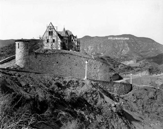
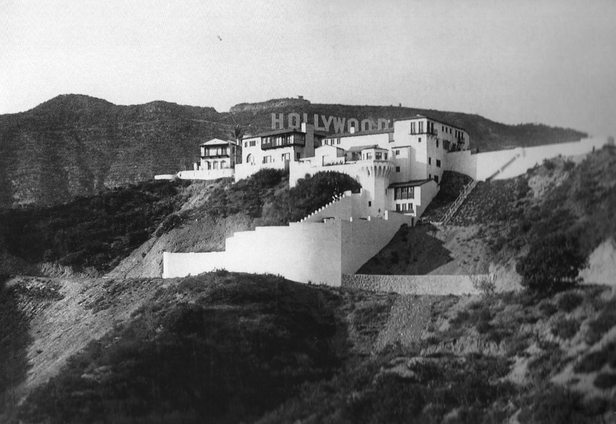
| (1928)***^ - View of a nearly completed home (Wolf's Lair) sitting alone on top of a hill fronted by a large wall with a turret. The "Hollywoodland" Sign can be seen in the background. No other homes are seen in this photo. |
Historical Notes This Norman Revival castle was constructed in 1928 by Hollywoodland art director and developer, L. Milton Wolf. The guesthouse was designed by architect John Lautner. |
 |
|
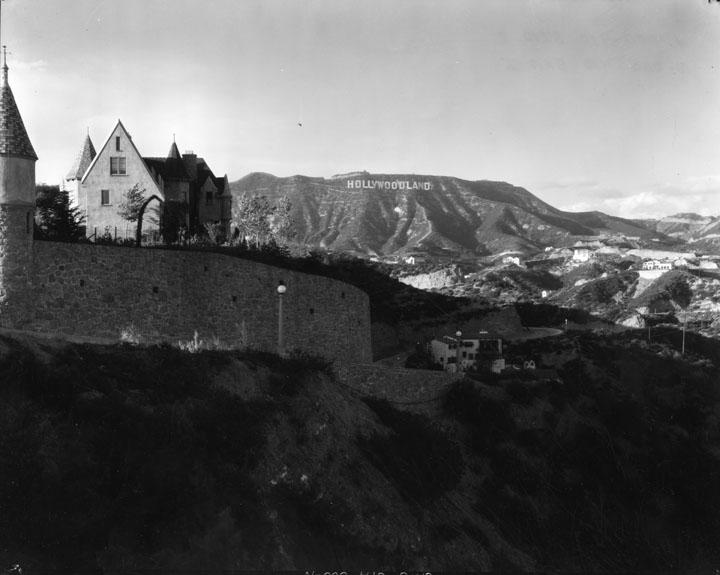
| (ca. 1930s)* - Almost identical view of Wof's Lair as seen in the previous photo but taken approximately 10 years later. A multitude of new homes have sprung up throughout the Hollywood Hills in a relatively short time span. |
Historical Notes According to Wolf’s grandson, Efram Zimbalist, Jr. briefly lived there in the 1970s. So did actress Shelley Duvall and her boyfriend, Patrick Reynolds. The mansion also became a filming location for Return from Witch Mountain (1978), starring Bette Davis and Christopher Lee.^ |
 |
|
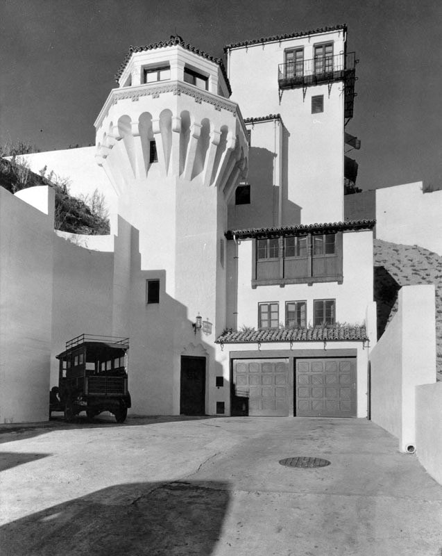
| (ca. 1930s)* - Close-up view of the garage entrance to Wolf’s Lair located at 2869 Durand Drive in the Hollywood Hills. Click HERE for contemporary view. |
Historical Notes Around 1981, real estate broker Bob Crane bought the castle. In 1996, Wolf’s Lair would be sold to Disney executive Phillip Barlow. The castle would change hands several more times over the next decade. In 2001, Barlow sold the property to Oprah producer Debra DiMaio. A year later, DiMaio sold it to Lionsgate Entertainment executive Jay Faires and his wife, Debbie Matenopoulos, former co-host of “The View.” In 2008, Faires and Matenopoulos tried selling their castle for $7.5 million. However, they couldn’t find a buyer willing to pay that price. In 2010, NYC techno music composer and musician Moby bought the castle for $3,925,000. He then spent an additional $2 million restoring it back to its 1920s roots. Moby would go on to sell Wolf Lair Castle in 2014 for $12.4 million.^^ |
* * * * * |
Castillo del Lago
 |
|
| (ca. 1926)^ - View showing the very large Mediterranean-style Castillo del Lago in the Hollywood Hills. The Hollywoodland Sign can be seen in the distance at upper-right. Another large letter H appears at upper-left. It was made by students from Hollywood High School. |
Historical Notes The Spanish colonial style castle called Castillo del Lago was built by oil baron Patrick Longden in Beachwood Canyon in 1926. It was designed by Architect John DeLario, the primary architect of the original Hollywoodland tract. |
 |
|
| (1926)^ – Closer view showing the magnificent Castillo del Lago with part of the Hollywoodland Sign visible behind it. |
Historical Notes At various times in its history, Castillo del Lago has been vacant, a white elephant during the Depression and beyond. Older adults who grew up in Beachwood tell stories of using it as a neighborhood clubhouse, entering through unlocked doors to play in the tower and on the stairs. * |
 |
|
| (1926)*– Driveway leading to the garage of the Spanish Colornial style Castillo del Lago. |
Historical Notes In the late 1930’s, a newcomer to Beachwood leased the house: Benjamin “Bugsy” Siegel, the gangster best known for spearheading the post-war casino boom in Las Vegas. Though he later took up residence in Beverly Hills, Siegel apparently lived in Castillo del Lago for a time while running it as an illegal casino. (It was not a speakeasy, as many people have claimed, as Prohibition was repealed in 1933.)* Castillo del Lago would later go through a succession of owners, most famous being "Material Girl" Madonna 1993 - 1997). Click HERE to see more early views and history of Castillo del Lago. |
* * * * * |
 |
|
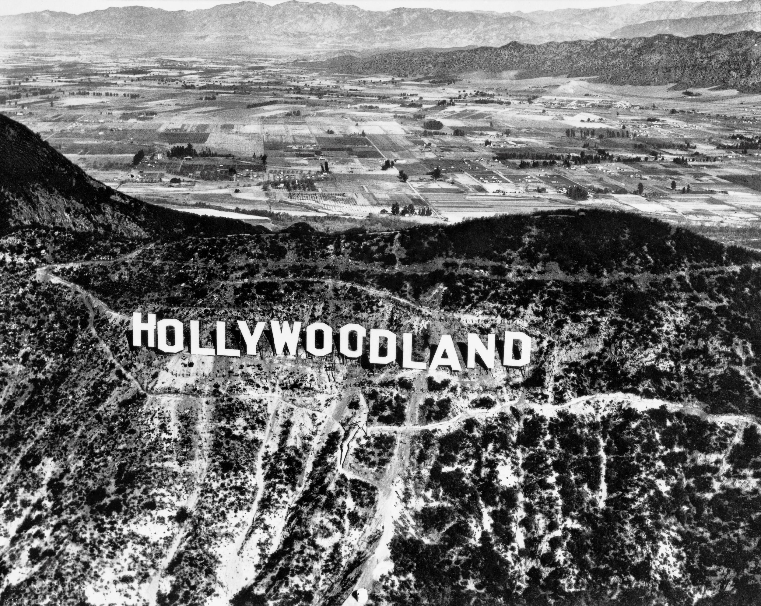
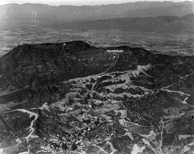
| (ca. 1920s)** - Aerial view of the Hollywoodland Sign showing the newly developed land in the foreground as well as the farmland of the San Fernando Valley behind the Hollywood Hills. The HOLLYWOODLAND Sign sits below Mt. Lee. Another sign ( just the letter 'H') is seen to the left on top of Mt. Cahuenga. It was made by students from Hollywood High School. Also, note the large WHITE DOT under the Hoolywoodland Sign. |
Historical Notes Built in 1923 by Harry Chandler as a billboard for his Hollywoodland real estate development, the Hollywood Sign located on the top of Mount Lee was declared Los Angeles Historic-Cultural Monument No. 111 in 1973 (Click HERE to see complete listing).* |
 |
|
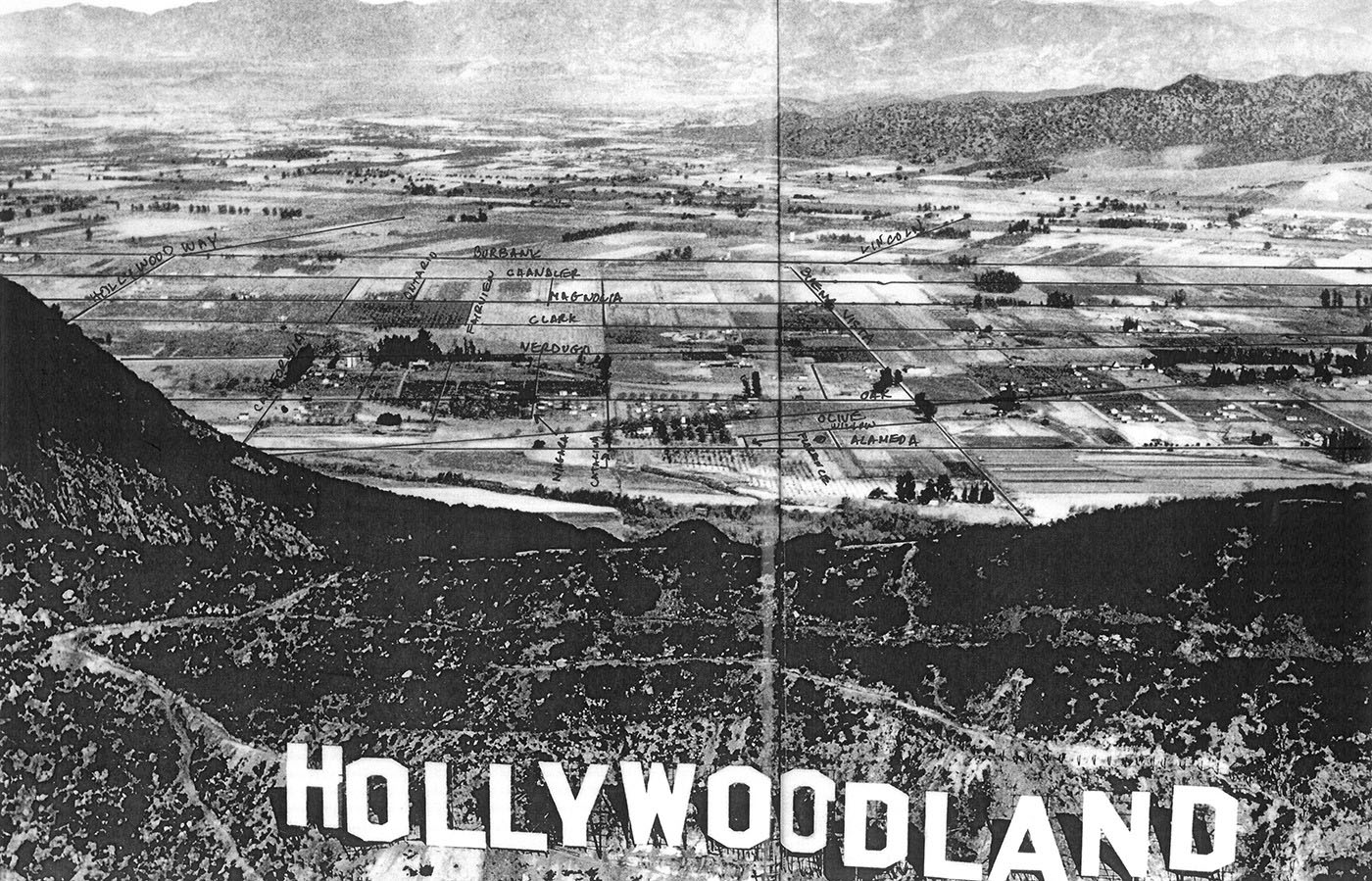
| (ca. 1924)*# - Panoramic look over the “Hollywoodland” Sign and over the ridge of the Hollywood Hills showing a detailed view of Burbank with streets annotated. Note the vast amount of farmland and open fields. |
Click HERE to see more in Early Views of the San Fernando Valley |
 |
|
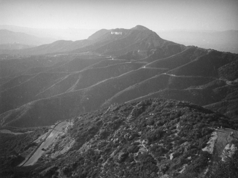
| (ca. 1938)* - Panoramic view of Mount Lee and the Hollywoodland Sign from the peak of Mount Hollywood. |
Historical Notes In 1896 Griffith J. Griffith donated over 3000 acres of Rancho Los Felis to the City of Los Angeles to create a public park in his name. Mount Hollywood, the highest peak of the park, rises to an elevation of 1640 feet. Griffith Park was declared Los Angeles Historic-Cultural Monument No. 942 in 2009 (Click HERE to see complete listing).* |
 |
|
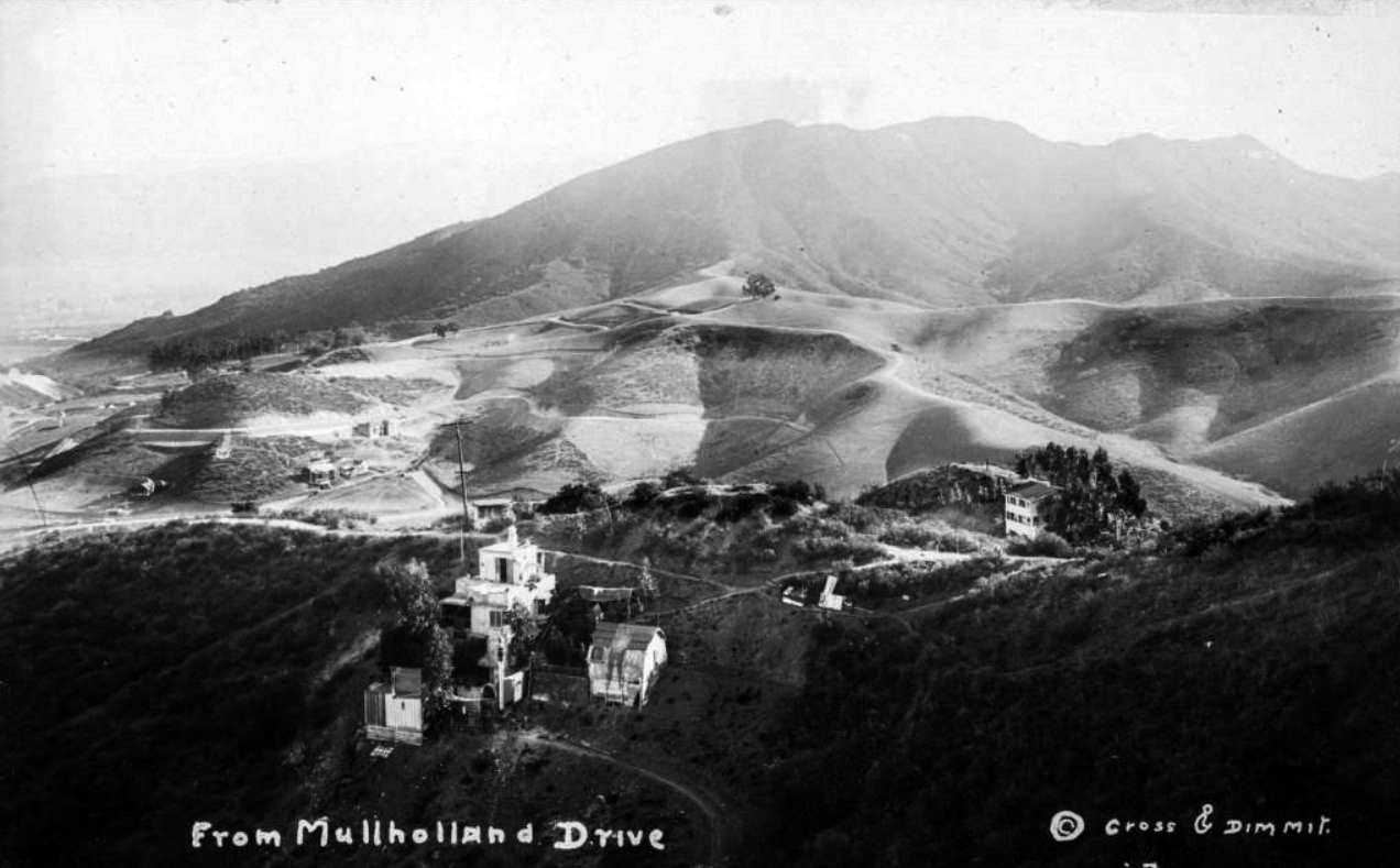
| (1920s)^** - Postcard view looking north showing the Hollywood Hills from Mulholland Drive, with a few houses in the foreground and a faint view of the "Hollywoodland" Sign in the upper right. Cahuenga Pass runs between the rolling hills at center and the mountains in the background. |
Cahuenga Pass
 |
|
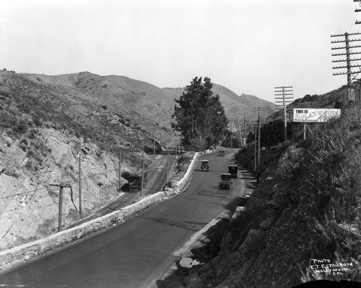
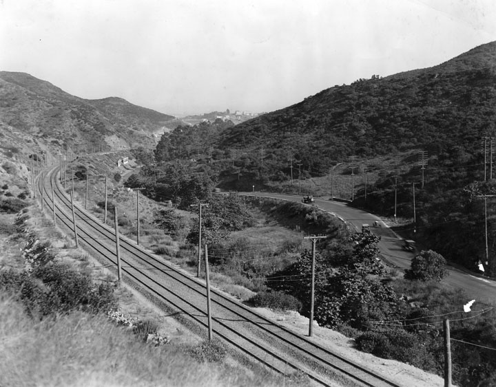
| (ca. 1920)* - Cars travel on the road past a sign reading "This is Hollywood." Below and to the left is the rail line, which also goes through the Cahuenga Pass. A trolley car is traveling on the tracks. |
 |
|
| (1923)^^ - View of Cahuenga Pass from new road leading from Holly Crest Station to new dam in Weed Canyon. |
 |
|
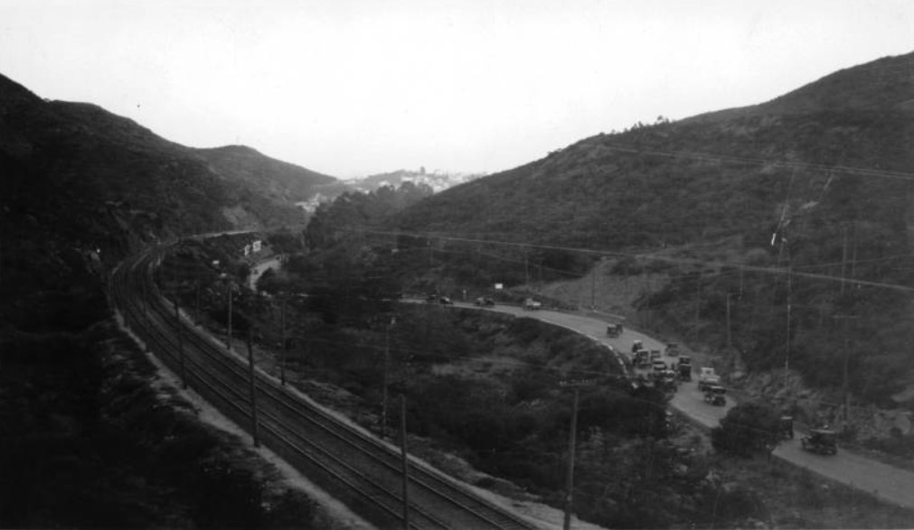
| (1922)* - On the left are the railroad tracks, and paralleling them on the right is the road for cars, both going through the Cahuenga Pass. |
Click HERE to see more Early Views of Cahuenga Pass |
 |
|
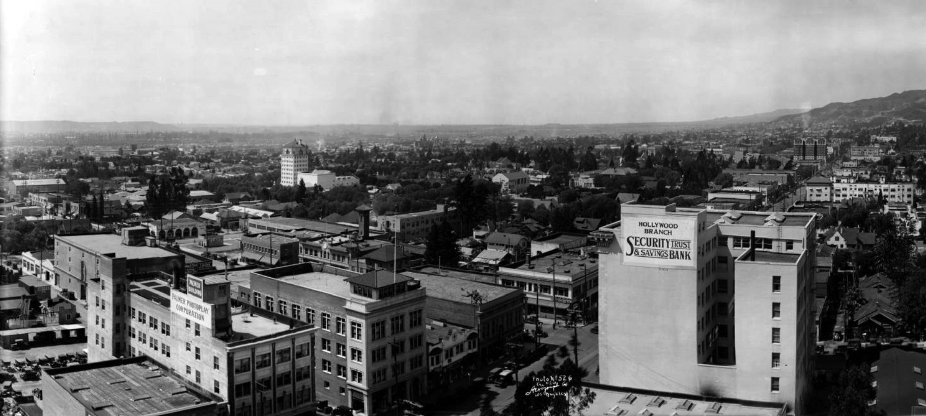
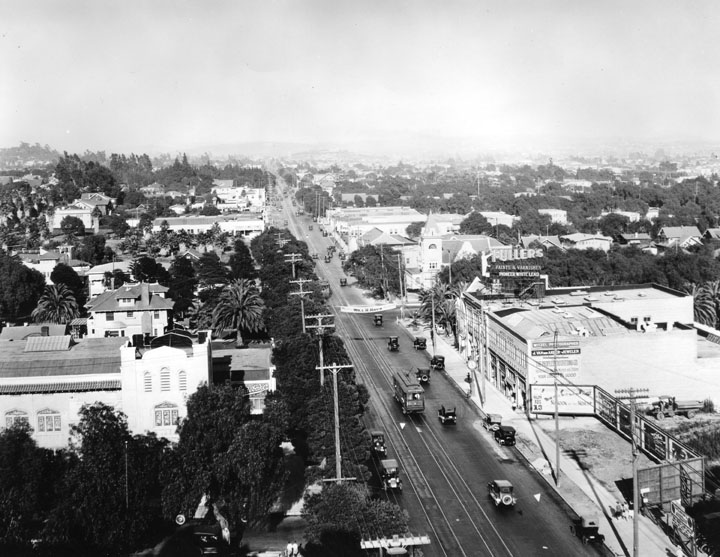
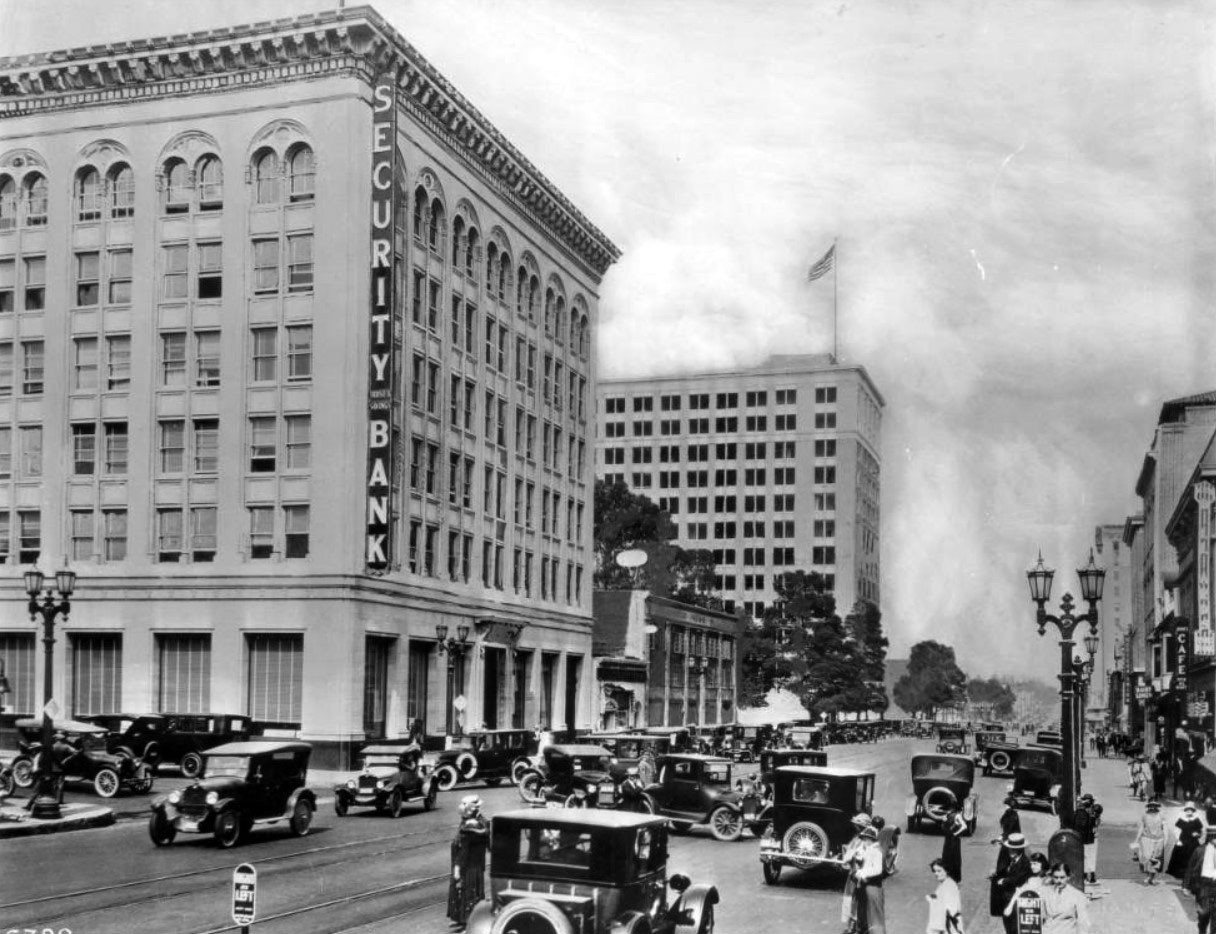
| (1924)^** – Panoramic view looking southwest showing Hollywood as it appeared in 1924. Hollywood Boulevard is seen in the foreground running diagonally from lower-center to upper-right. The large building at lower right is the Security Trust and Savings Bank, Hollywood Branch, located at the northeast corner of Cahuenga and Hollywood. At upper-right stands the 8-story, 3-tower Hotel Christie. The tall white building at center-left is the newly constructed Hollywood Athletic Club located on Sunset Boulevard. |
 |
|
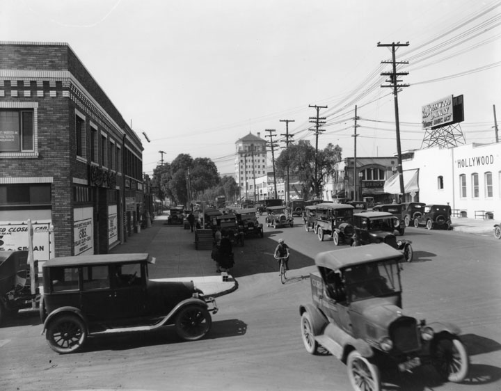
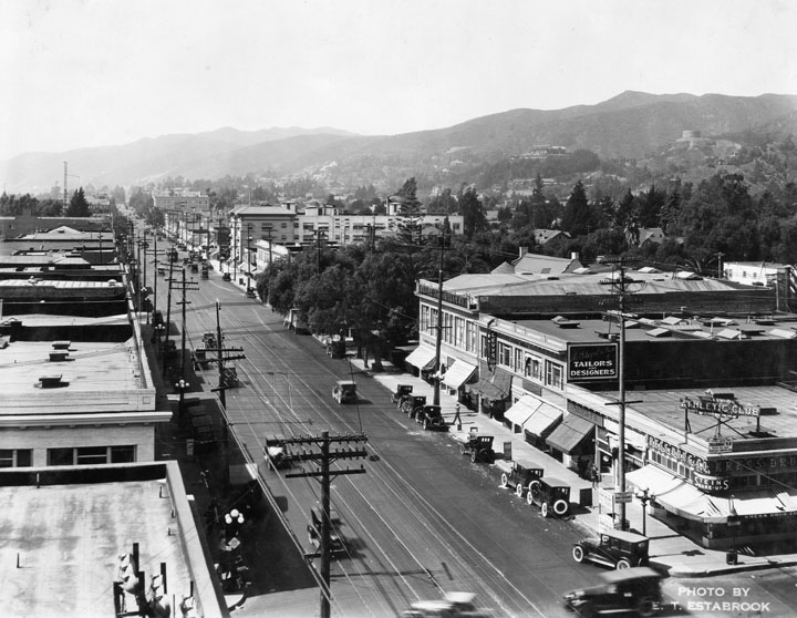
| (ca. 1924)* - View looking west on Sunset Boulevard from Cahuenga Boulevard with heavy traffic going in all directions. The tall tower in the center of the photo is the Hollywood Athletic Club. |
Hollywood Athletic Club
 |
|
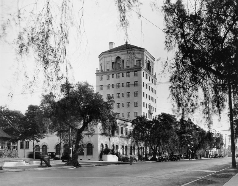
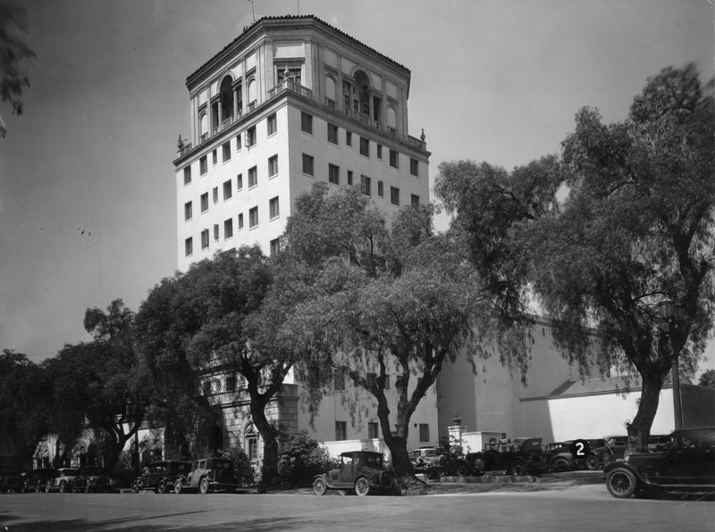
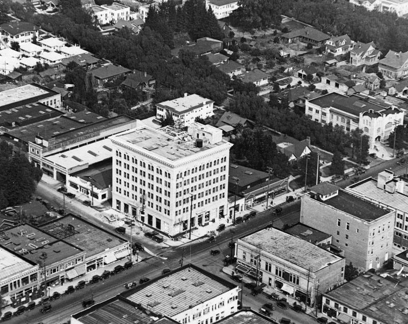
| (ca. 1925)* - Exterior corner view of the Hollywood Athletic Club building, with 1920s-era cars on the street. |
Historical Notes When the Hollywood Athletic Club was first built in 1924, Hollywood was entering its greatest and most productive period. The building was the tallest building in Hollywood and loomed above Sunset Boulevard. Membership was originally $150 for initiation fees and $10 for monthly dues. During its early years as a health club, its membership included Johnny Weissmuller, Errol Flynn, Charlie Chaplin, John Wayne, Walt Disney, John Ford, Douglas Fairbanks Sr., Mary Pickford, Cecil B de Mille, Cornel Wilde, Humphrey Bogart, Clark Gable, Jean Harlow, Frances X. Bushman, Howard Hughes, Joan Crawford and Rudolph Valentino, Mae West, Walt Disney, and Buster Crabbe.*^ |
 |
|
| (1929)* - Street view of the Hollywood Athletic Club, located at 6525 Sunset Blvd. |
Historical Notes The Hollywood Athletic Club was built in 1924 by Meyer & Holler, the same architectural firm that built the Grauman's Chinese Theatre and the Egyptian Theatre. At the time is was the tallest building in Hollywood. The building at 6525 Sunset Blvd has been known as the Hollywood Athletic Club, University of Judaism, Berwin Entertainment Complex, and Hollywood Landmark.*^ |
* * * * * |
 |
|
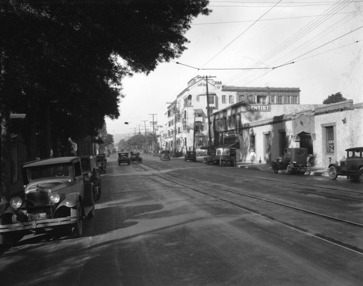
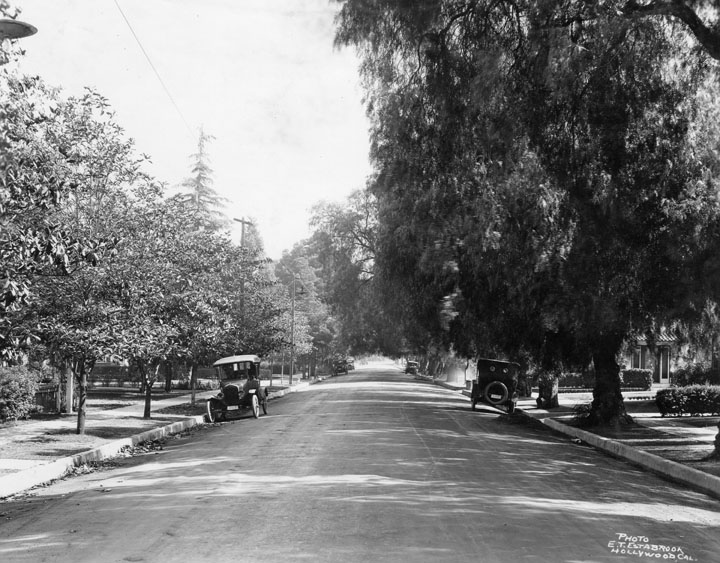
| (ca. 1920s)* - View of Franklin Avenue. Cars are parked on both sides of the street with light traffic, and a dentist sign can be seen to the right. |
 |
|
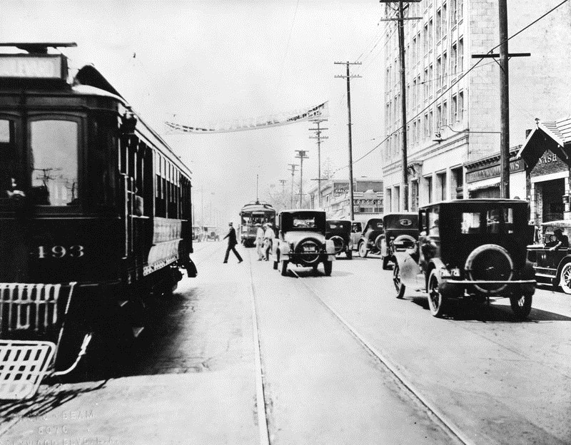
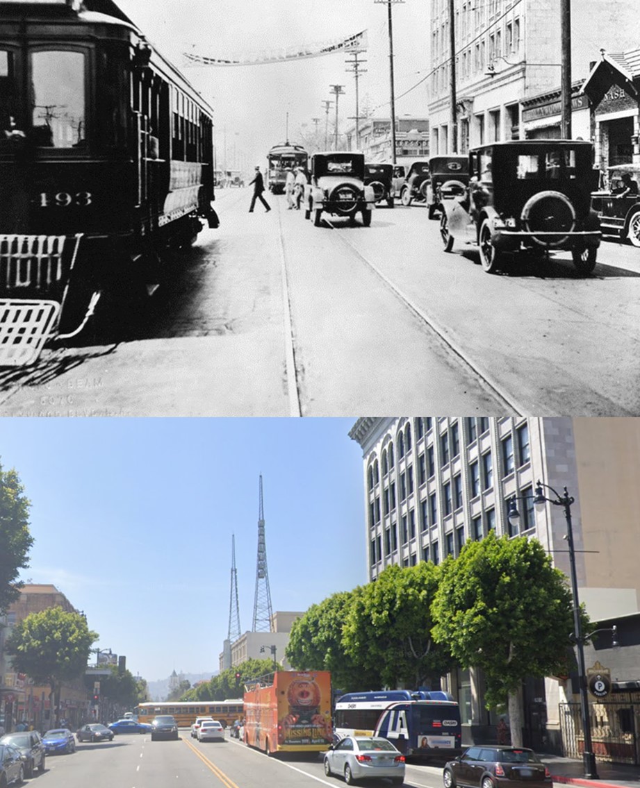
| (1920s)* - Looking west on Hollywood Blvd. toward Cahuenga Blvd. In the foreground is street car no. 493, in the background are 1920's cars and another street car. Over the street is a banner, reading: The Wayfarer at the Coliseum, Sept. 8-15. |
Then and Now
 |
|
| (1920s vs. 2020s)* – Looking West on Hollywood Boulevard toward Cahuenga. |
Vitagraph Studio (today Prospect Studios)
 |
|
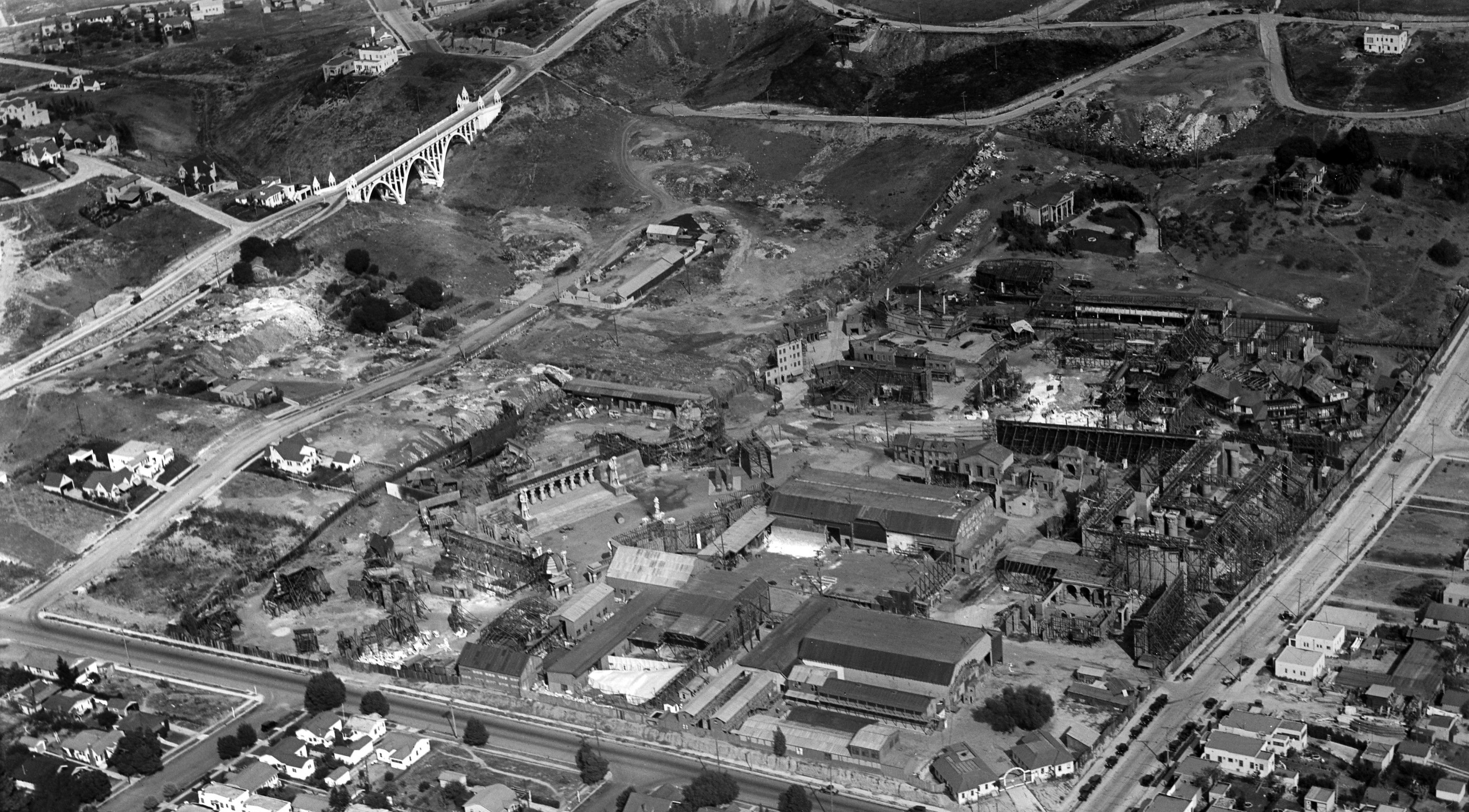
| (ca. 1926)*# – Panoramic aerial view looking northeasterly showing the Vitagraph Studio (today, Prospect Studios) at the corner of Prospect and Talmadge Avenues (named in honor of silent screen star Norma Talmadge), just east of Hollywood. Prospect Avenue runs east-west and merges into Hollywood Boulevard as it heads west past Vermont Avenue. In the upper-left can be seen the newly built (1926) Shakespeare Bridge on Franklin Avenue. Click HERE to see more of the Shakespeare Bridge. |
Historical Notes The Vitagraph Company was one of the biggest motion picture studios in the early era of American film. Originally founded in Brooklyn, NY in 1897, they established another studio on 2nd Street in Santa Monica in 1911 (Click HERE to see more). That studio only lasted there until 1915 because the persistent fog made filming so difficult that they moved to 4151 Prospect Avenue in Hollywood (seen above).* The original silent film plant included two daylight film stages, support buildings and many exterior film sets. In 1925, Vitagraph's founder Albert Smith sold the company to the Warner brothers. In 1927, the facility became The Warner East Hollywood Annex and was used for many large-scale films. Here, in 1927, Warner Bros. shot portions of the historical first sound film, The Jazz Singer, using the Vitaphone process which synchronized audio and picture. In 1948, the property was sold to the newly formed American Broadcasting Company, and the film lot was transitioned into the new world of television as the ABC Television Center. In 1996, ABC became part of The Walt Disney Company, the origins of which trace back to its first studio in Silver Lake. As the television and film industry entered the next millennium, the lot was renamed The Prospect Studios.*^ |
 |
|
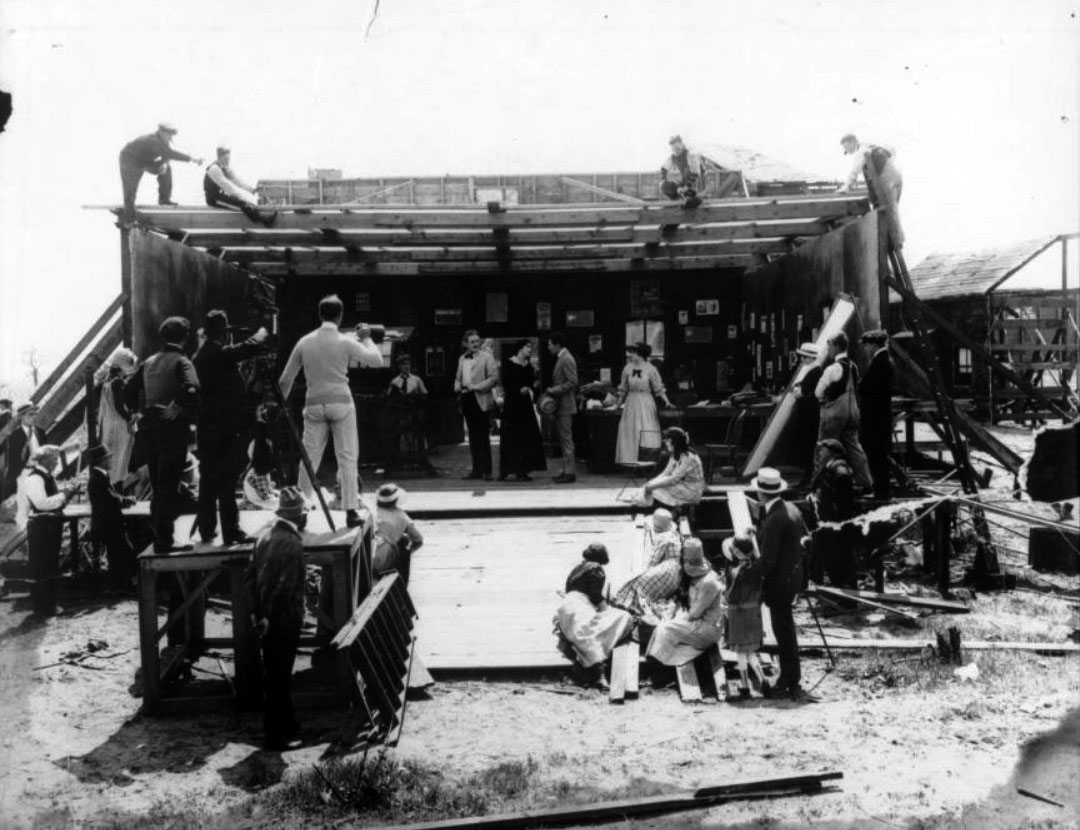
| (1917)^^ - View of an outdoor film set at Vitagraph Studios, showing a film shoot in progress. A film set sits in the grass at the center of the image, bounded by wooden walls on all sides except for the front. Several workers sit on the top of the set, while other crew members sit in the grass in front of the set. The camera sits on a platform in the left centerground of the image, along with the cameraman and director. |
Metro Studios
 |
|
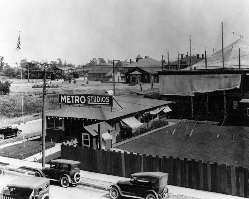
| (1920)* - An early view of various stuctures and offices on the Metro Studios lot, located at 1025 Lillian Way in Hollywood. |
Historical Notes Metro Pictures Corporation was founded in early 1915, with Richard A. Rowland as president, and Louis B. Mayer as secretary. Mayer left to form his own production unit in 1918. Metro's biggest stars during the World War I period were the romantic teams of Francis X. Bushman and Beverly Bayne and Harold Lockwood and May Allison. Also in top echelons of importance was popular actress Viola Dana.*^ |
_1920s.jpg) |
|
| (1920s)* - Exterior view of Metro Studios, near the intersection of Romaine Street and Cahuenga Boulevard. |
Historical Notes In 1920, the company was purchased by Marcus Loew as a supplier of product for his theater chain. A few years later in 1924, Loew merged it with his recently acquired Goldwyn Pictures, then renamed the new entity Metro-Goldwyn-Mayer in 1925 with Mayer in charge. Although the Metro film library and stars were merged into MGM in 1924, Rowland's Los Angeles film studio continued a life of its own. It was known simply as Motion Picture Studios through the 1940s, General Service Studios, and Desilu Studios through the 1950s and 1960s. It became Ren-Mar Studios in 1974. In January 2010, Ren-Mar Studios was bought by Red Digital Cinema Camera Company. The complex was renamed "Red Studios – Hollywood" It is located on Cahuenga Blvd. north of Melrose Avenue in Hollywood (directly behind the Musicians AFM Local 47 on Vine Street).*^ |
University of California, Los Angeles (later Los Angeles City College)
 |
|
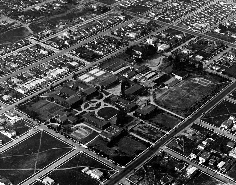
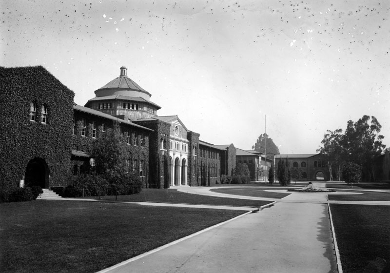
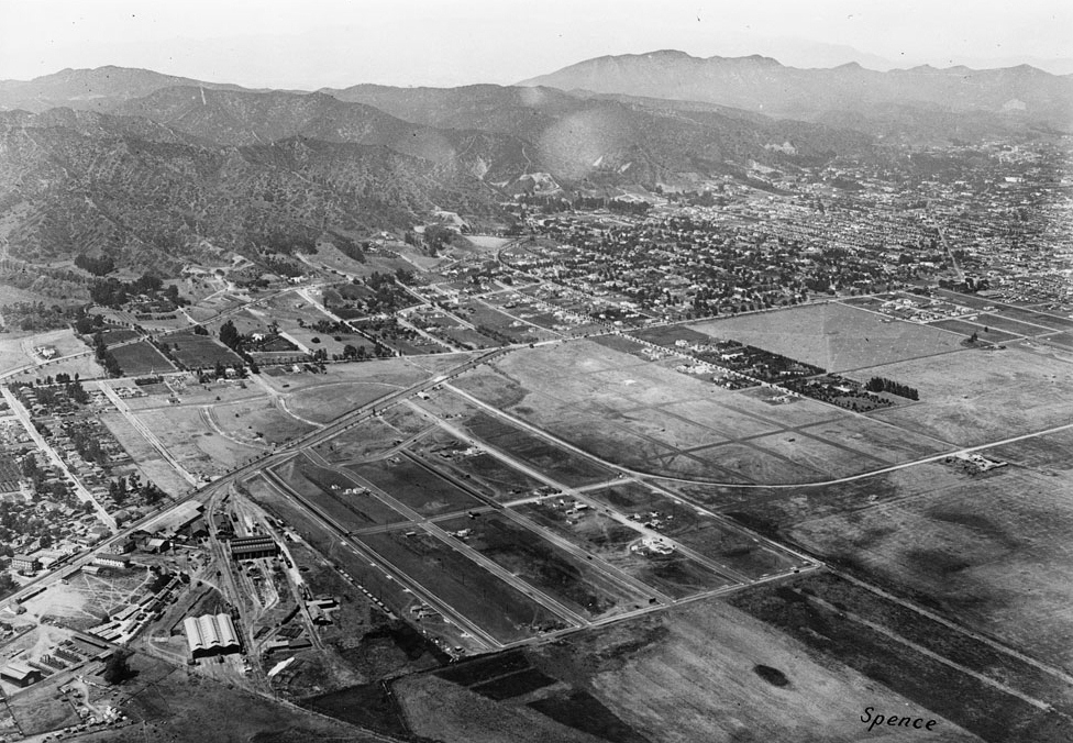
| (1922)* - Aerial view of the old Vermont Avenue campus of the University of California, Los Angeles, which later became Los Angeles City College. Vermont Avenue runs from the bottom of the photo to the right. Built in 1914, the East Hollywood campus was designed by Allison and Allison, architects. |
Historical Notes The University of California, Los Angeles (also known as UCLA) evolved from the Los Angeles branch of the California State Normal School (founded in 1888). In 1919 the school obtained university status and became the Southern Branch of the University of California, located at 855 N. Vermont Avenue. |
 |
|
| (ca. 1920)* - The ivy-covered Beaux-Arts style building with the flared polygonal dome (seen on the left) is Millspaugh Hall, the Administration building of the University of California, Southern Branch, located at 855 N. Vermont Avenue |
Historical Notes On May 31, 1929 the University of California, Los Angeles opened its new campus in Westwood. Shortly thereafter, on September 9, 1929, Los Angeles Junior College was established on the Vermont Avenue campus. |
Click HERE to see more Early Views of UCLA. |
* * * * * |
Granada Theater (later West Coast Hollywood Theater, Oriental Theater, Guitar Center)
 |
|
| (ca. 1921)^.^ – View looking west on Sunset Boulevard at Vista Street showing the Granada Theatre at center of photo. |
Historical Notes Today, a Sam Ash Music Store is located at the corner of Sunset and Vista and The Guitar Center is where the Granada Theatre used to be. Click HERE for contemporary view. |
 |
|
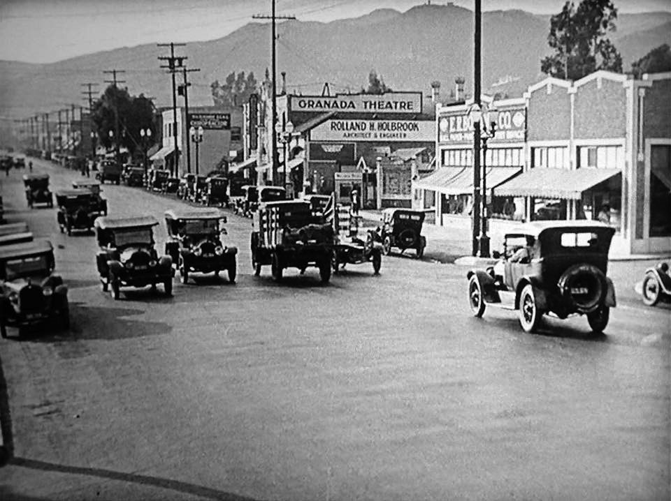
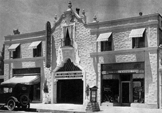
| (ca. 1921)^^* - Close-up view of the Granada Theater (later Oriental Theater) located at 7425 Sunset Boulevard, Hollywood. |
Historical Notes Built in 1921, Architects Meyer & Holler designed the theatre in a fanciful Spanish style befitting its original name, the Granada. In 1929 it was known as the West Coast Hollywood Theater. By 1932 it was the Oriental.^^* |
.jpg) |
|
| (ca. 1932)*# - View of the north side of Sunset Boulevard east of Gardner Street. The Oriental Theater is running a movie starring Bette Davis and Pat O Brien. |
 |
|
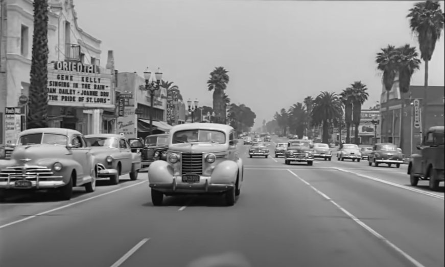
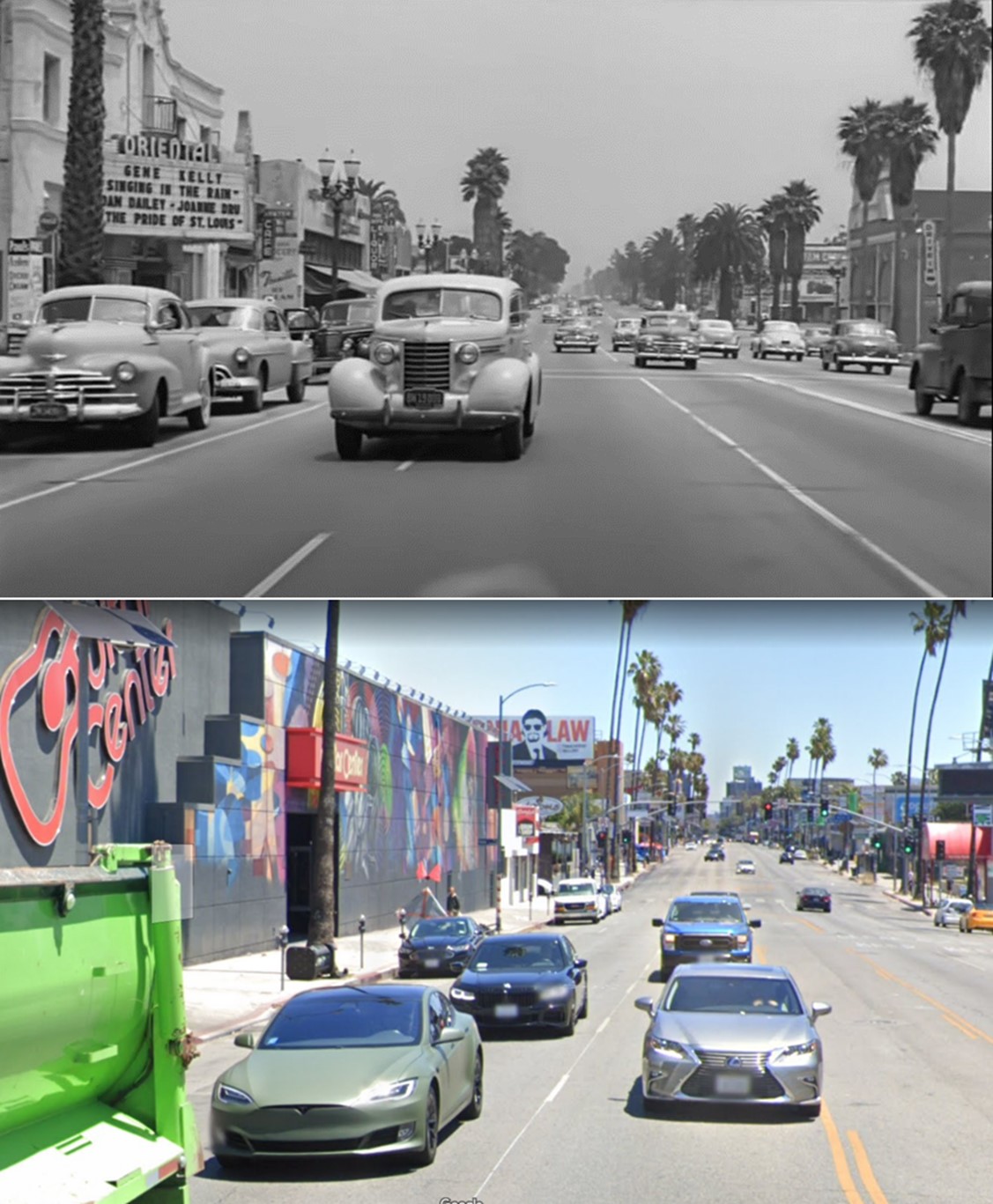
| (1952)* – Looking east on Sunset Boulevard with the Oriental Theatre seen on the left. Featured movie is ‘Singing in the Rain’ with Gene Kelly. |
 |
|
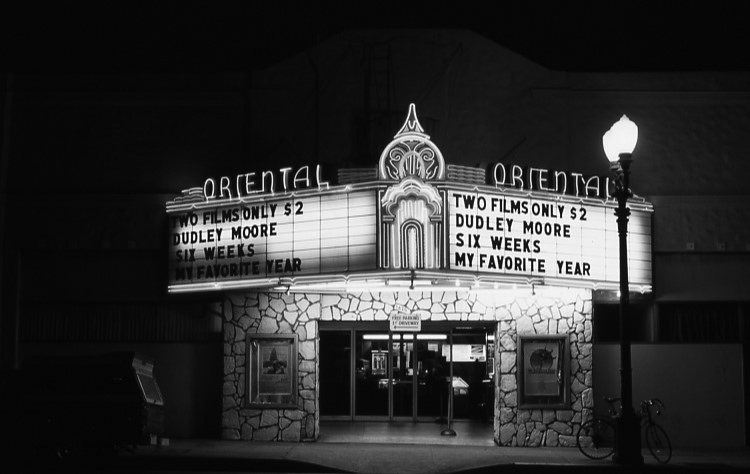
| (1983)^^ – Night view of the Oriental Theatre located at 7425 Sunset Boulevard on the north side of Sunset between Vista and Gardner streets in Hollywood. |
Historical Notes The Oriental Theater closed in 1985 and has been converted into the Guitar Center, with the building now altered. Clcik HERE for contemporary view. |
Then and Now
 |
|
| (1952 vs 2022)* – Looking east on Sunset Boulevard toward Vista Street in front of the Oriental Theater. The theater closed in 1985 and then was converted into the Hollywood Guitar Center. |
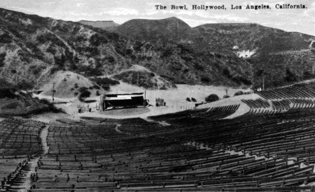
Hollywood Bowl
 |
|
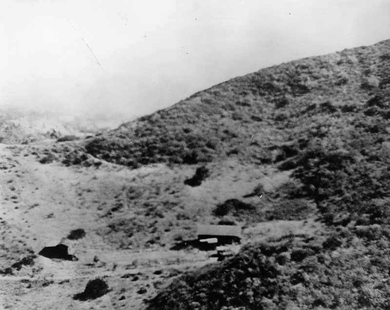
| (ca. 1918)* - View of the large hillside on which the Hollywood Bowl would be built. There are two or three small wooden buildings at center on a part of the hill that has been cleared of trees. The hillside at left is still wooded and in the distance at left, parts of the city of Hollywood are visible. |
Historical Notes The site of the Hollywood Bowl was chosen in 1919 by William Reed and his son H. Ellis Reed, members of the newly formed Theatre Arts Alliance who were dispatched to find a suitable location for outdoor performances.*^ |
 |
|
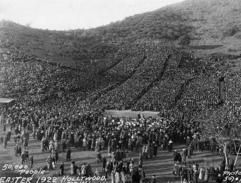
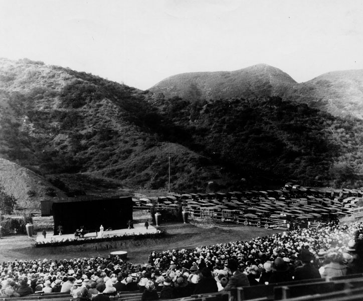
| (1922)* - Around 50,000 people gathered for the Easter sunrise service in the Hollywood Bowl. An even larger crowd was expected there on Easter morning when the Los Angeles Philharmonic Orchestra played for the worshipers. The Hollywood Bowl would officially be opened four months later (July 11, 1922). |
 |
|
| (1922)*^#* – Postcard view of the Hollywood Bowl showing its new covered wooden stage. The large open space to the right is a parking lot. In the upper center-right can be seen the Pilgrimage Theatre (later John Anson Ford Theatre). |
Historical Notes The Pilgrimage Amphitheatre was built in 1920. The author, Christine Wetherill Stevenson, believed the rugged beauty of the Cahuenga Pass would provide a dramatic outdoor setting for The Pilgrimage Play. Together with Mrs. Chauncey D. Clark, she purchased this land along with that on which the Hollywood Bowl now sits. A wooden, outdoor amphitheater was built on this site and the play was performed by noted actors every summer from 1920 to 1929, until the original structure was destroyed by a brush fire in October 1929. In 1976, the Pilgrimage Theatre was renamed the John Anson Ford Theatre in honor of the late L.A. County Supervisor's significant support of the arts.*^ |
 |
|
| (ca. 1922)* - Concert by Rosa Paniella at the Hollywood Bowl prior to its official opening. Note the full parking lot to the right of the stage. |
 |
|
| (1922)* - Hollywood Bowl at first Symphony Under the Stars. This was the "Bowl's" official opening and was on the site of a natural amphitheater formerly known as the Daisy Dell. |
Historical Notes On July 11, 1922, with the audience seated on simple wooden benches placed on the natural hillsides of Bolton Canyon, conductor Alfred Hertz and the Los Angeles Philharmonic inaugurated the first season of music under the stars at the Hollywood Bowl. While much has changed in the ensuing years, the tradition of presenting the world's greatest musicians and striving for musical excellence has remained a constant goal of this famed Los Angeles cultural landmark.*^ |
 |
|
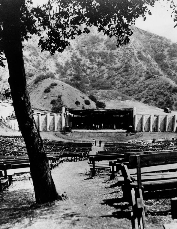
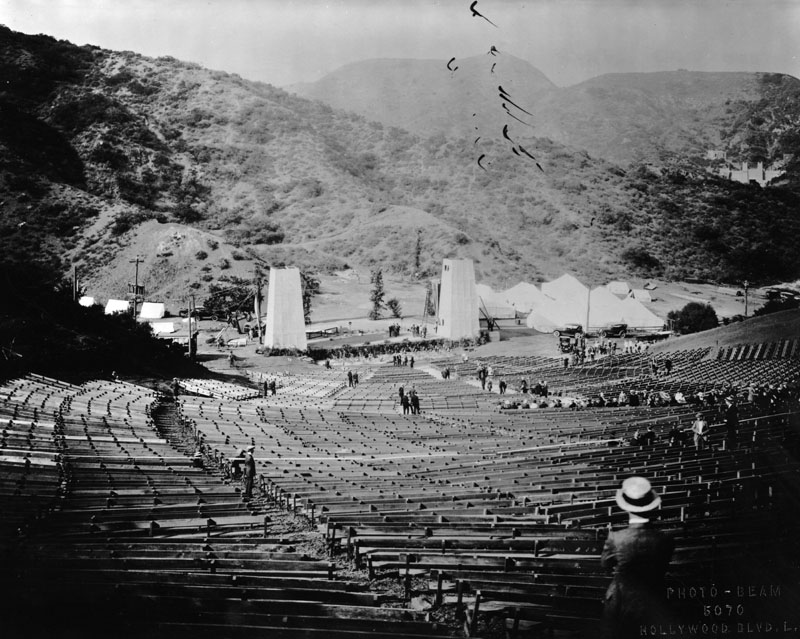
| (1923)* - View of the Hollywood Bowl as seen from the top of the seating, looking down towards the stage. |
Historical Notes At first, the Bowl was very close to its natural state, with only makeshift wooden benches for the audience, and eventually a simple awning over the stage. In 1926, a group known as the Allied Architects was contracted to re-grade the Bowl, providing permanent seating and a shell. These improvements did provide increased capacity (the all-time record for attendance was set in 1936, when 26,410 people crowded into the Bowl to hear opera singer Lily Pons), but were otherwise disappointing, as the re-grading noticeably degraded the natural acoustics, and the original shell was deemed acoustically unsatisfactory (as well as visually unfashionable, with its murals of sailing ships). For the 1927 season, Lloyd Wright built a pyramidal shell, with a vaguely Southwestern look, out of left-over lumber from a production of Robin Hood. This was generally regarded as the best shell the Bowl ever had from an acoustic standpoint; unfortunately, its appearance was deemed too avant-garde, and it was demolished at the end of the season. It did, however, get Wright a second chance, this time with the stipulation that the shell was to have an arch shape.*^ |
Click HERE to see more in Early Views of the Hollywood Bowl |
* * * * * |
Hollywood Boulevard
 |
|
| (1921)* - In this aerial view a church can be seen behind the trees in the lower left corner of the picture. This is the South Methodist Church, located on the S.W. corner of Hollywood Blvd. at Ivar Avenue. This church was later moved to the vicinity of Sunset Blvd. & Vista where it now stands. Cars and a trolley are on the street, while a paint company is located on the right side of the picture. |
 |
|
| (1922)* - An aerial view of Hollywood Boulevard looking west from above Cahuenga Boulevard. On the corner on the right (NW corner) is the Kress Drug Co. Other businesses extend on down the street, broken in the middle of the picture by a block of trees. The Hollywood Hills are seen in he background. |
 |
|
| (1922)* - Aerial view looking northeast above the intersection of Hollywood and Cahuenga boulevards. The newly constructed Security Trust and Savings Bank is seen on the NE corner. |
Historical Notes Until August 3, 1887, the NE corner of Hollywood and Chahuenga was a fig and apricot orchard. As late as 1912 Paul de Longpre's flower garden was on one corner and tennis courts were where the bank stands.^^ |
 |
|
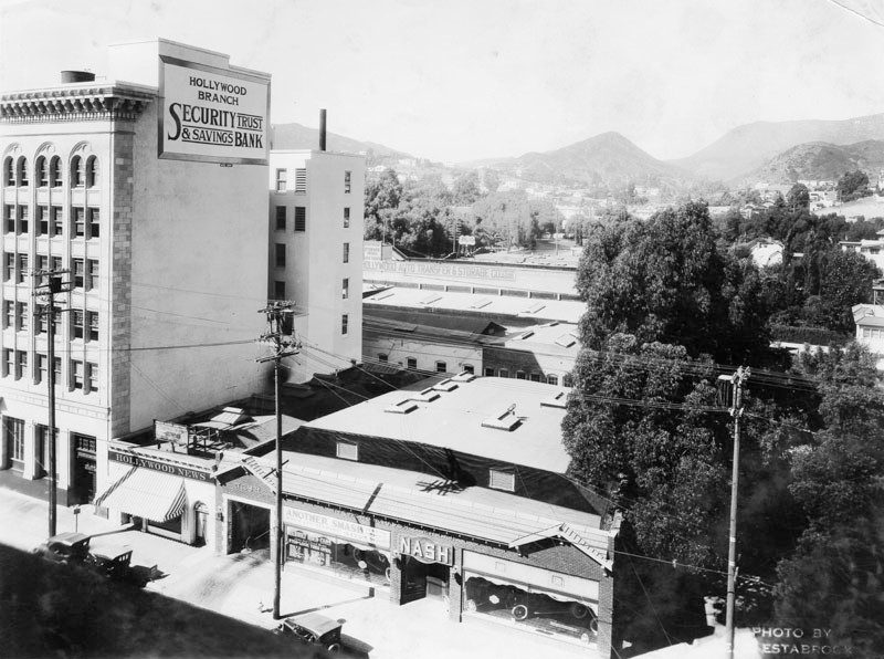
| (1922)* - Panoramic view of Hollywood looking north showing the Hollywood Branch of Security Trust & Savings Bank (NE corner of Hollywood and Cahuenga), Hollywood News, and a Nash automobile dealership. Behind is the Hollywood Auto Transfer & Storage Co. |
Security Trust and Savings Bank (aka Security Pacific Bank)
 |
|
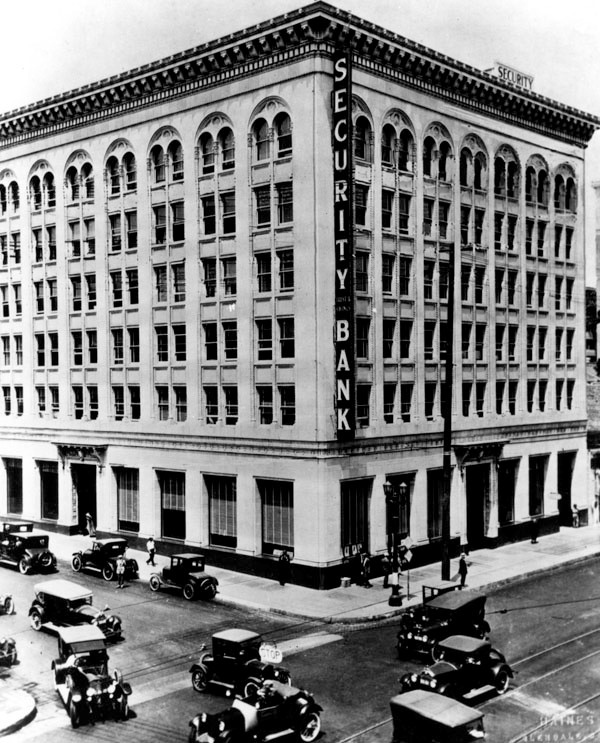
| (ca. 1922)* - View looking at the northeast corner of Hollywood and Cahuenga boulevards showing the new Security Trust and Savings Bank at 6381 Hollywood Boulevard. |
Historical Notes Also known as Security Pacific Bank, this Italian Romanesque / Beaux Arts block of a building was the pioneer of Hollywood’s “skyscrapers.” Built in 1921 by the famous father son duo John and Donald Parkinson (notable for the Title Guarantee Building, LA Memorial Coliseum, LA City Hall, LA Union Station), the Security Trust & Savings building was the tallest building in Hollywood at the time of its grand opening in 1922. As was fitting for the unveiling of such a landmark, the opening was attended by thousands of Los Angeles bigwigs and was complete with a live orchestra, performance artists, and tours of the bank and its vaults. Originally founded at Main Street in downtown Los Angeles as the Security Savings Bank by Joseph F. Sartori in 1888, the institution soon changed its name to Security Trust and Savings Bank. As the city and surrounding areas exploded with new residents, the bank quickly built new branches, extending tentacles all over Southern California. The outlying area of Hollywood mushroomed in size from a tiny farming village in 1900 to a more fashionable suburban town in 1920, with new film studios seeming to open virtually every day. Security’s small branch at Hollywood and Cahuenga overflowed with customers, and the bank decided to build a fashionable, larger building across the street at 6381 Hollywood Blvd. that would allow it to grow over the years.* |
 |
|
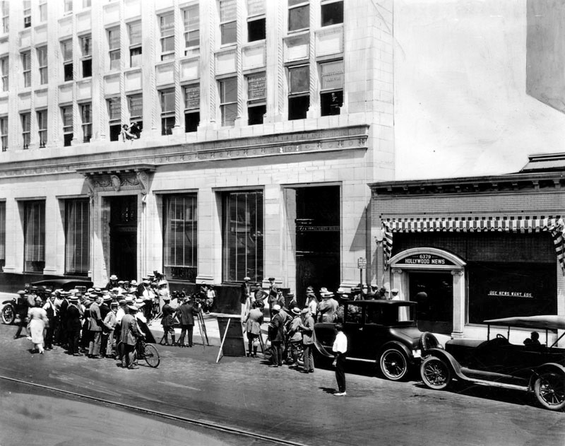
| (1920s)* - A movie company can be seen at work in front of the Security Trust and Savings Bank, located at Hollywood Boulevard and Cahuenga. A large crowd has gathered to watch the crew film this scene, which appears to have three young men dressed in some type of uniform. The Hollywood News Building is adjacent on the right, at 6379 Hollywood Boulevard. |
Historical Notes Almost as soon as it opened, the building and its surrounding area became a favorite filming location for comedians Buster Keaton, Harold Lloyd, and Charlie Chaplin. Film Historian John Bengtson notes that the area featured frequent filmmaking because of its close proximity to each comedian’s studio.* |
 |
|
| (ca. 1927)^^ – View looking east on Hollywood Boulevard at Chauenga Boulevard. The Security Trust & Savings Bank building stands on the NE corner. The building has most of its Venetian blinds drawn, even in the arched windows on the top floor. Shorter, commercial buildings line the boulevard to the right, advertising themselves. Two traffic signs in the extreme foreground read "Right or Left". Other signs include: "Hollywood News Bldg.", "Billiards", "John's Café / Open All Night", "Dairy Lunch", and "Western Union". |
Historical Notes Allegedly this bank branch was where Howard Hughes stored his prized jewels, Cecil B DeMille sought film financing, and Charlie Chaplin and the Three Stooges did their regular banking. These days, the intersection of Hollywood and Cahuenga, where the former bank stands, has been dubbed “Raymond Chandler square,” in homage to the iconic LA crime novelist whose legendary private detective protagonist Philip Marlowe was purported to have held his fictional office in the Security Trust & Savings building.^ |
 |
|
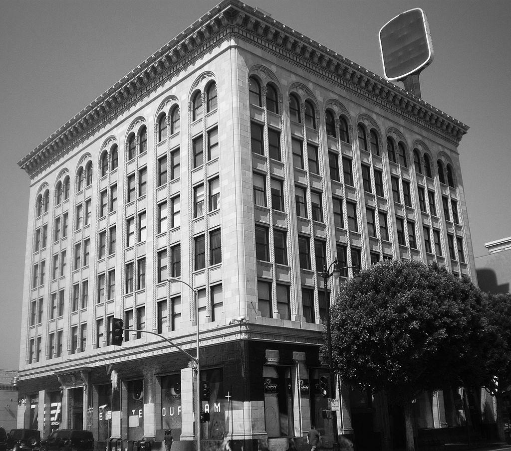
| (2008)*^ – View showing the Security Trust and Savings building as it appears today, 6381-85 Hollywood Blvd. |
Historical Notes Over the later decades of the 20th century, as Hollywood largely slid into disrepair, the building suffered some dark years, hosting more transients than actual tenants. The building remains boarded up on the first floor, but is home to a collection of random office tenants on the floors above.^ In 1983, the Security Trust and Savings building was listed on the National Register of Historic Places. |
* * * * * |
Charlie Chaplin Studios (later A&M Records and The Jim Henson Company)
 |
|
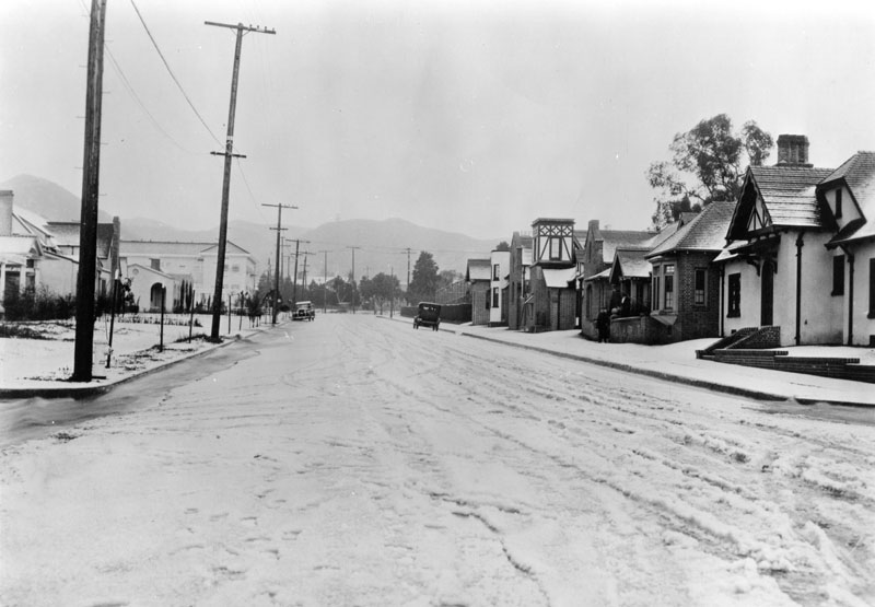
| (1921)* - Snow in Hollywood! View looking north on La Brea Avenue toward the Hollywood Hills. The street is covered with snow with the Charlie Chaplin Studios seen on the right. |
Historical Notes In October 1917, Charlie Chaplin announced plans to build his own motion picture studio at the southeast corner of La Brea and Sunset Boulevard. The location was at that time a residential neighborhood, and Chaplin's application for a building permit was opposed by area residents, some of whom complained that it was too near the Hollywood High School. However, the City Council voted 8–1 to approve Chaplin's permit. Chaplin purchased the site from R.S. McClellan, who lived on the site and had a large grove of old orange trees on the property. The lot had 300 feet of frontage on Sunset and 600 feet on La Brea, extending south to De Longpre. Chaplin announced he would make his home on the northern part of the property, and build his own motion picture plant on the south part of the property, cornering at La Brea and De Longpre. Chaplin's plans for six English-style buildings, "arranged as to give the effect of a picturesque English village street," were published in the Los Angeles Times in October 1917. The plans were prepared by the Milwaukee Building Company (Meyer & Holler), and the total investment was estimated to be approximately $100,000. The layout of the buildings was described by the Los Angeles Times in 2002 as a "fairy-tale cottage complex."Another writer has described the style as "eccentric Peter Pan architecture." *^ |
 |
|
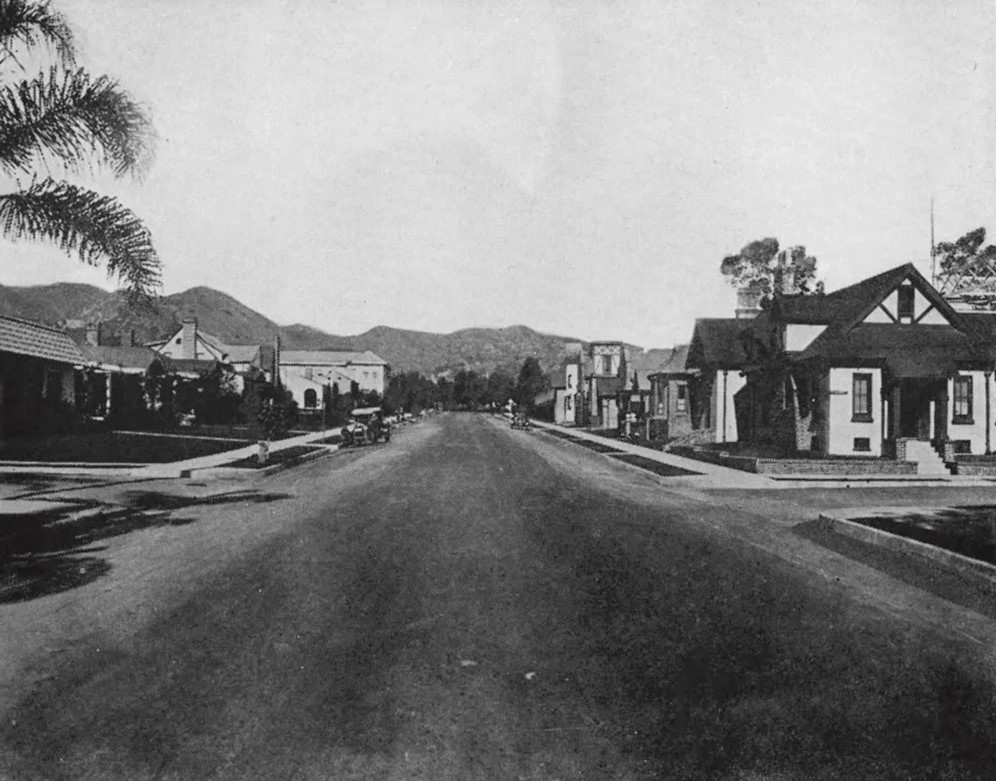
| (1920s)* – Looking north on La Brea Avenue at De Longpre Avenue showing the Charlie Chaplain Studios on the right. |
Historical Notes The above photo came from a local newspaper article with subtitle that read: ‘The picture studios do not drive the residences away. The buildings on the right hand side of this street constitute Charlie Chaplain’s Studio.’ |
Now and Then
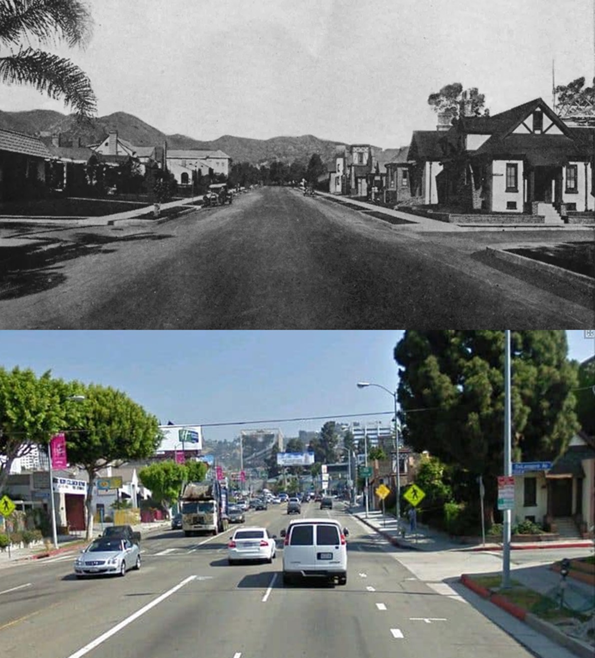 |
|
| (Then and Now)* – Looking north on La Brea Avenue at De Longpre Avenue showing the Charlie Chaplain Studios on the right. |
Historical Notes The early photo came from a local newspaper article with subtitle that read: ‘The picture studios do not drive the residences away. The buildings on the right hand side of this street constitute Charlie Chaplain’s Studio.’ |
 |
|
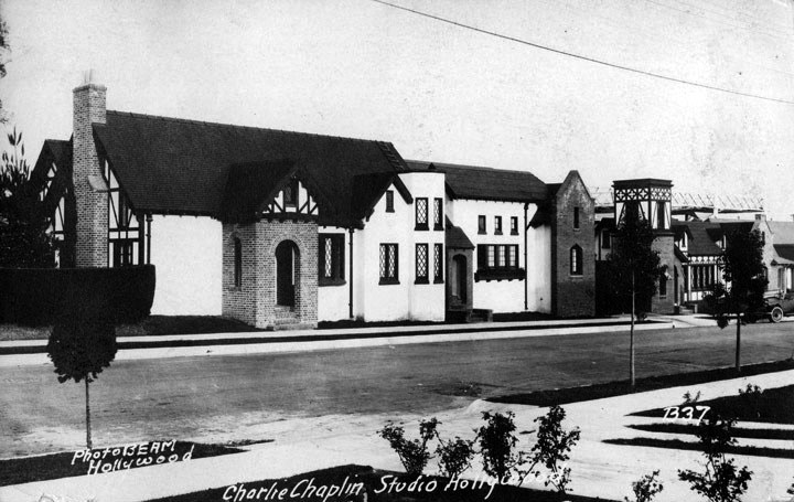
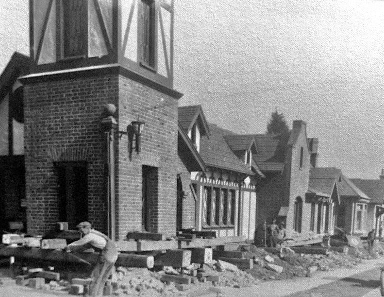
| (1922)*^ - Postcard view of the entrance to the Charlie Chaplin Studios located at 1416 N. La Brea Avenue, just south of the southeast corner of La Brea and Sunset Boulevard in Hollywood. Note how narrow La Brea Ave is (it was widened in 1929). |
Historical Notes Many of Chaplin's classic films were shot at the studios, including The Kid (1921), The Gold Rush (1925), City Lights (1931), Modern Times (1936), The Great Dictator (1940), Monsieur Verdoux (1947), and Limelight (1952). |
 |
|
| (1929)#**# – View showing workers uplifting the Charlie Chaplin Studio buildings on the east side of La Brea Ave and moving them back as part of a street widening project. Click HERE to see contemporary view. |
Historical Notes Due to the growth Los Angeles was experiencing in 1929, it was deemed that La Brea Ave needed to be widened. And so the buildings on the east side of the street were picked up and moved back 15 feet. |
.jpg) |
|
| (1960s)^ – View showing the Perry Mason Studios, previously Charlie Chaplin Studios. Photo Courtesy of Bison Archives |
Historical Notes Chaplin sold the studio in 1953 to some television producers, the "New Adventures of Superman," was shot there. Then it was purchased by Red Skelton, and he used it for his show, "The Red Skelton Hour," one thing Skelton did, was to remove the cement with Chaplin's hand and foot prints in it from 1918, and he moved it to his home in Palm Springs. Skelton sold the studio to CBS and from 1962-1966 it was called the Perry Mason Studios, where the show was shot. It later became the headquarters for A&M Records and The Jim Henson Company. |
 |
|
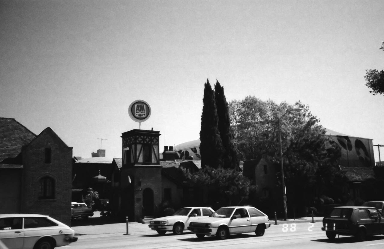
| (1988)^ – View showing the A&M Studios Main Gate on La Brea in Hollywood. |
Historical Notes In 1966, Herb Alpert and Jerry Moss purchased the studio from CBS to serve as a headquarters for A&M Records. A&M Records had grown from $500,000 in revenues in 1964 to $30 million in 1967. Alpert and Moss reportedly "astonished the big network by having their bank deliver a cashier's check for more than $1 million, the full amount. A&M converted two of the old soundstages and Chaplin's swimming pool into a recording studio. The elderly Chaplin briefly revisited his former studio in 1972, when he made his only return trip to America to accept an honorary Academy Award. A&M had hoped to welcome him back with a ceremony, but instead he chose to avoid the attention and arranged to drive by the studio gates on a weekend.* |
 |
|
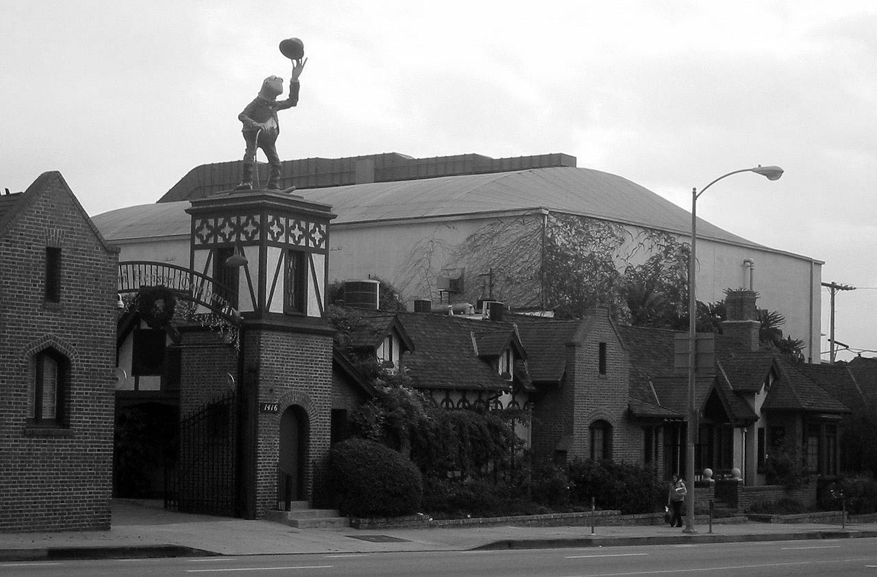
| (2016)^ - Jim Henson Studios at 1416 N. La Brea Avenue, Hollywood, CA (Originally Chaplin Studios). |
Historical Notes In February 2000, Jim Henson's children purchased the studio for $12.5 million to serve as the new home of The Jim Henson Company. Henson's daughter, Lisa Henson, said, "The buildings are a lovable hodge-podge of quirky, unusual spaces. There are unexpected elements in some of the offices like original vaults and fish tank-like bathrooms. It's not your typical corporate space, but it's ideal for the Muppets." At a ceremony in June 2000, the Henson Company unveiled a 12-foot color statue of Kermit the Frog, dressed as Chaplin's character The Tramp, above the studio's main gate. Henson's son, Brian Henson, said at the time, "When we heard that the Chaplin lot was for sale, we had to have it. It's the perfect home for the Muppets and our particular brand of classy, but eccentric entertainment. When people walk onto our lot, they fall in love with Hollywood again."* |
Then and Now
 |
|
| Then and Now, Chaplin Studios.* |
Then and Now
 |
|
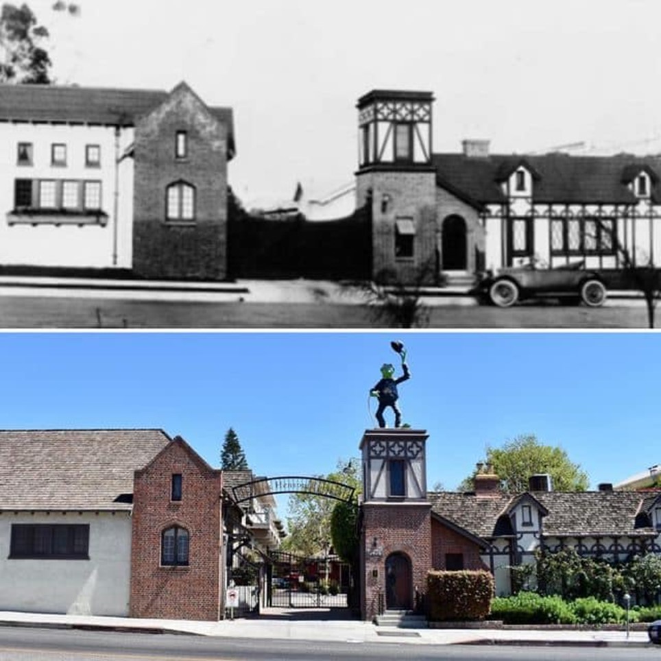
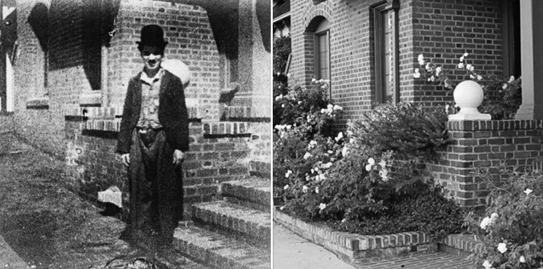
| (1920s vs. 2018)^.^ - Charlie Chaplin standing in front of his studios at 1416 N. La Brea Avenue in Hollywood. On the right is same view today. Photo courtesy Ray Durlav |
Historical Notes In 1969, the former Charlie Chaplin Studio was designated Los Angeles Historic-Cultural Monument No. 58 (Click HERE to see complete listing). |
* * * * * |
 |
|
| (ca. 1922)* - Looking west from Sunset Boulevard where it meets Highland Avenue. Hollywood High School can be seen on the northwest corner to the right. |
Hollywood High School
 |
|
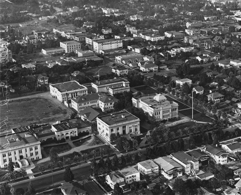
| (1922)* - An aerial view of Hollywood High School from the southwest. There is practice of some kind on the athletic field. Palm trees line the campus on Sunset and Highland. The original 1905 building is on the bottom right. The Household & Fine Arts building is in the middle of the quadrangle and the gymnasium is to its left when facing Highland. |
Historical Notes The school with a student body of 2500 was three blocks from Charlie Chaplin's studio and six blocks from Mary Pickford's and Douglas Fairbanks' studios. The homes bordering the upper side of the campus were just condemned by the city to make room for additional buildings. The original 1905 building is on the bottom right, the Household & Fine Arts building is in the middle of the quadrangle, and the gymnasium is top, center.* |
 |
|
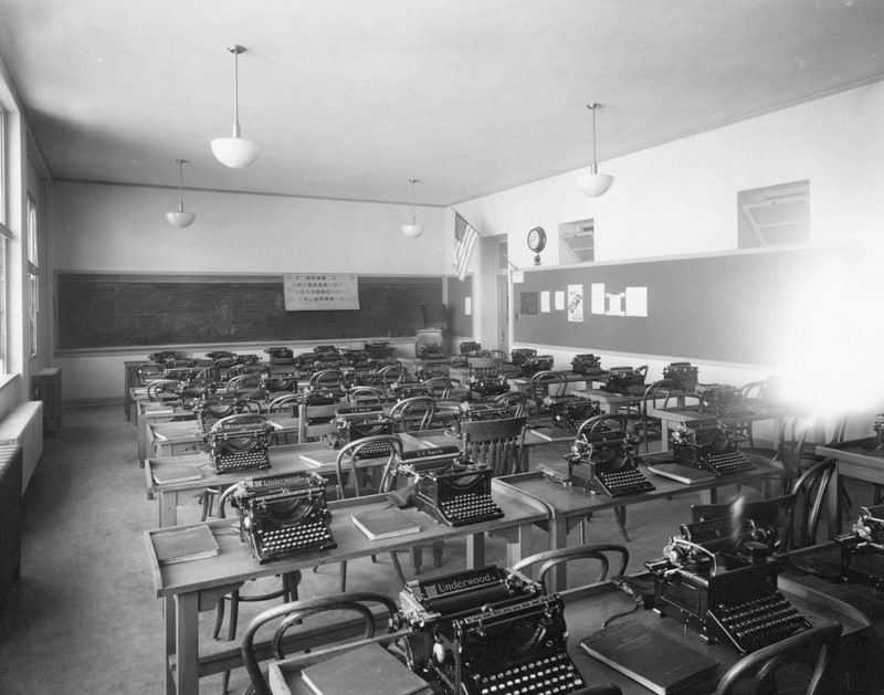
| (ca. 1920s)* - Each desk has a typewriter and textbook "New Intensive Typing" in this view of Hollywood High's typing classroom. A keyboard chart displays prominently in front and the lid is open on the record player that stands next to the door. There is a sign for the Science Club and a "Wanted: a Safe Driver" poster on the wall. The various typewriters are "Underwood", "L.C. Smith", "Remington" and "Woodstock". |
Historical Notes After their invention in the 1860s, typewriters quickly became indispensable tools for practically all writing other than personal correspondence. They were widely used by professional writers, in offices, and for business correspondence in private homes. By the end of the 1980s, word processors and personal computers had largely displaced typewriters in most of these uses in the Western world, but as of the 2010s the typewriter is still prominent in many parts of the world, including India.*^ |
 |
|
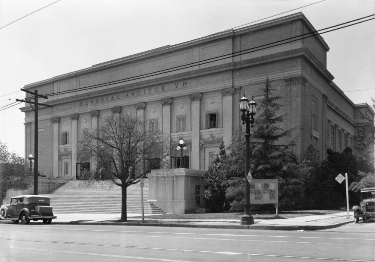
| (ca. 1929)^^ - View of the Hollywood High School Memorial Auditorium located on the southwest corner of Highland and Hawthorn avenues. A long stretch of stairs can be seen in front of the auditorium, leading up to five front entrances separated by eight Romanesque columns. Seven windows can be seen above the five front entrances. The words, "Memorial Auditorium" can be seen above the windows, at the top of the building, engraved in capital letters. |
Historical Notes The Auditorium was originally constructed in 1924. It was formally dedicated at commencement exercises on June 25, 1924 and named the Memorial Auditorium to honor the Hollywood High School graduates who died in World War I. The Auditorium is the second of only two buildings on campus that survived the Long Beach Earthquake of 1933. The original building was a Beaux Arts design that included a flat roof, masonry walls, and a symmetrical façade.*^#^ |
 |
|
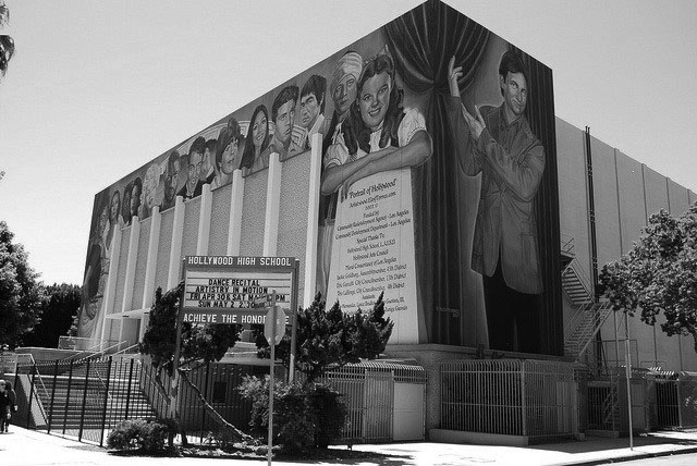
| (2010)^#*^ - The Hollywood High School mural, painted by Eloy Torrez. |
Historical Notes In 1956 the original Beaux Arts façade was altered to be Mid-Century Modern in style. The façade was refinished in concrete and gunnite. In 2002 artist Elroy Torrez painted the mural "Portrait of Hollywood" on the east-facing (primary) façade that features prominent graduates throughout Hollywood High School’s history. In 2008, to commemorate the 2003 death of John Ritter, a fifty-foot portrait of the actor was added to the mural on the north façade.*^#^ |
Click HERE to see more Early Views of Hollywood High School |
* * * * * |
Masonic Temple
 |
|
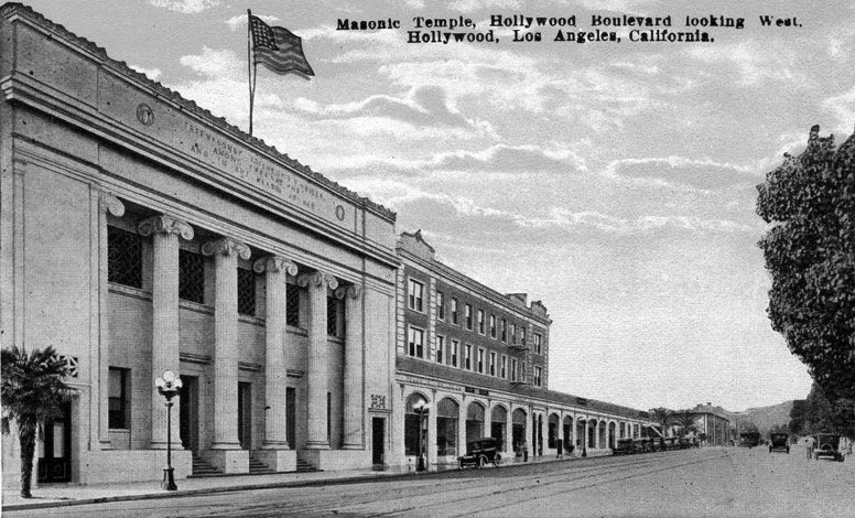
| (ca. 1922)^^^ – Postcard view looking west on Hollywood Boulevard showing the newly constructed Masonic Temple located at 6840 Hollywood Boulevard. |
Historical Notes In 1921, the Hollywood lodge of the Masons relocated from their existing lodge on the current site of the Kodak Theatre. The construction of the new three-story building was led by lodge master, Charles E. Toberman, who was responsible for the Hollywood Bowl, Grauman's Chinese Theatre, the Roosevelt Hotel and the Max Factor Building. |
 |
|
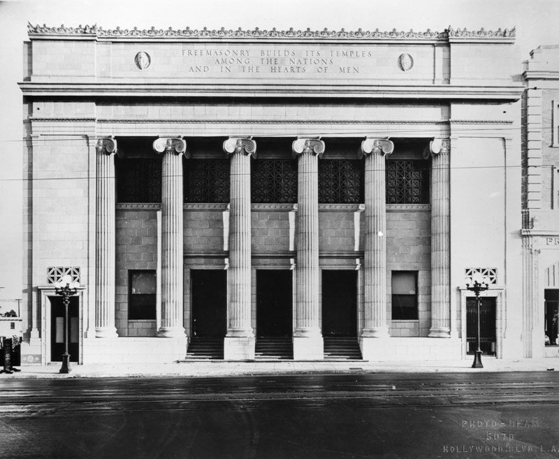
| (1922)* - Exterior view of the Masonic Temple located on Hollywood Boulevard between Highland and La Brea, in Hollywood. Building was built in 1922 and designed by Architects Austin, Field & Fry in a Greek Revival design with six tall pillars decorating the front entrance of the building. Note the two ornate 5-bulb streetlights in front of the building. Click HERE to see more in Early L.A. Street Lights. |
Historical Notes When the new temple opened, it was one of the most substantial structures in Hollywood. It had a billiard room, pipe organ, ladies parlor, ballroom and lodge rooms. One writer described the building as "unsurpassed for beauty, attractiveness and richness of equipment. The architect, John C. Austin also worked on the Shrine Auditorium, Griffith Observatory and Los Angeles City Hall.*^ In 1984, the Hollywood Masonic Temple was dedicated LA HIstoric-Cultural Monument No. 277 (Click HERE to see complete listing). The building, now known as the El Capitan Entertainment Centre, was also listed in the National Register of Historic Places in 1985. Click HERE to see contemporary view. |
* * * * * |
Santa Monica Boulevard
.jpg) |
|
| (1922)* - Passengers getting on a streetcar at Santa Monica Boulevard and Gower Street. |
Santa Monica and Western
 |
|
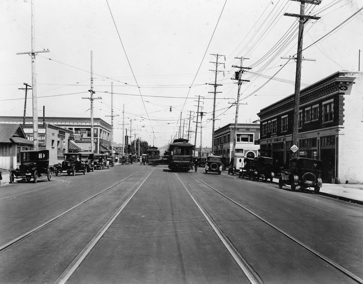
| (1922)* - View looking east showing two streetcars running down the center of Santa Monica Boulevard near Western Avenue. |
 |
|
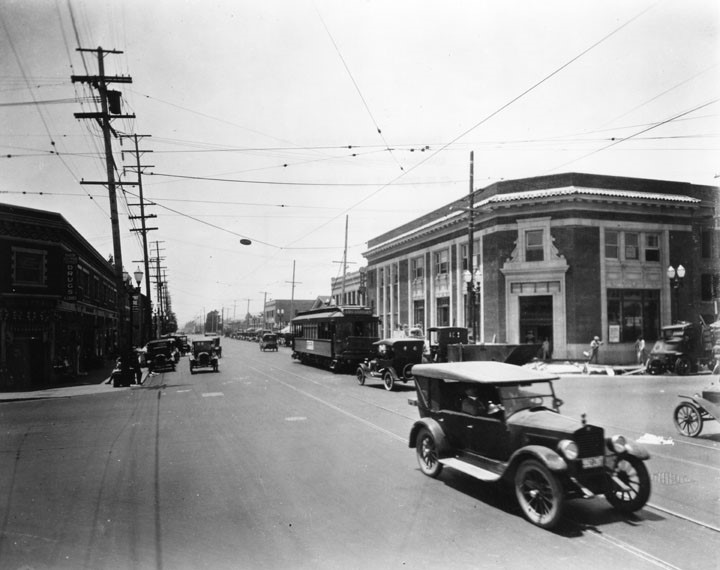
| (1923)* - View looking west on Santa Monica Blvd. at Western Ave. On the northwest corner (right) is future home of a branch of Security Trust & Savings Bank. The building is still under construction. |
 |
|
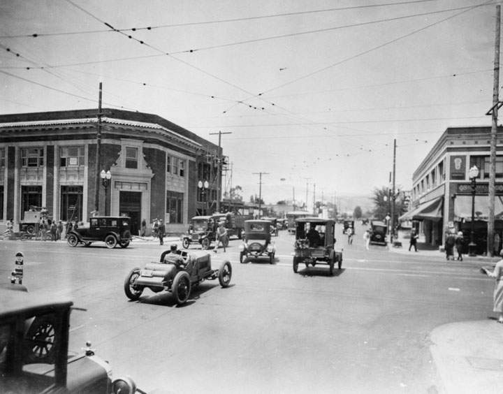
| (1923)* - View looking north at the intersection of Western Avenue and Santa Monica Boulevard. Pedestrians are seen crossing the street despite the heavy traffic. Note the sporty roadster convertible heading north on Western. The building on the left (NW corner) is still under construction and will become a Security Trust & Savings Bank. |
 |
|
| (1920s)* - View of Western Avenue looking north at its intersection with Santa Monica Boulevard. The Security Trust & Savings Bank Building is on the left hand side; billboards and businesses are across the street. Mt. Hollywood, the tallest peak in Griffith Park, can be seen in the distance. |
 |
|
| (ca. 1924)^^ - View of Santa Monica Boulevard looking east toward Western Avenue, Hollywood. At left, the Security Trust & Savings Bank Building can be seen on the northwest corner of Western and Santa Monica. On the right, southwest corner, is the Taft Public Market. |
 |
|
| (ca. 1927)*# – View looking west on Santa Monica Boulevard from Western Avenue. Featured prominently in the right of the photograph is the two-story office of a branch of the Security Trust and Savings Bank. A network of cables are stretched above the street, and cable car tracks are visible embedded in the roads. The white building in the distance is the newly constructed Sears Building. |
 |
|
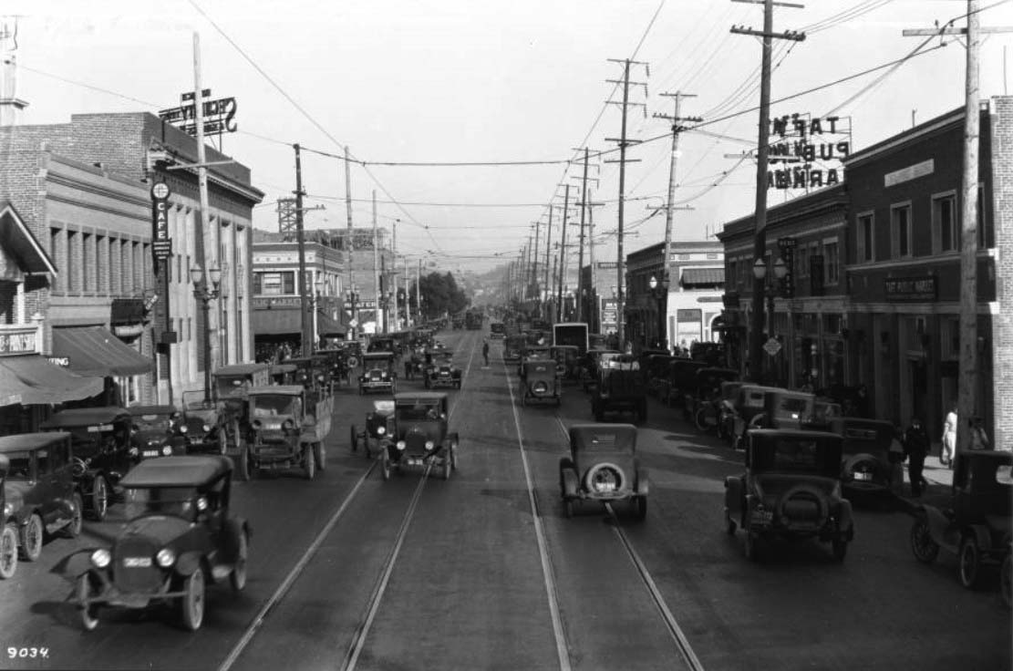
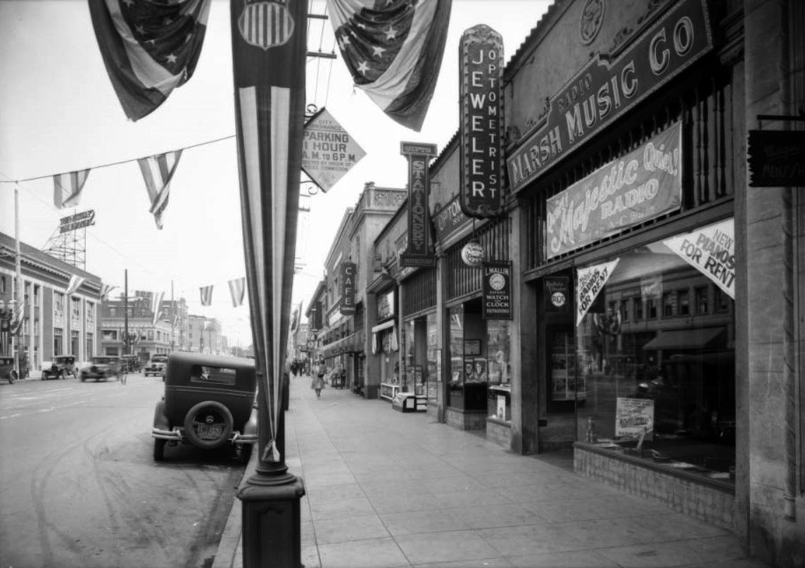
| (1930)^^ – View looking east on Santa Monica Boulevard toward Western Avenue with the Security Pacific Bank on the N/W corner. To the right is the Marsh Music Co. store at 5522 Santa Monica Boulevard. American flag banners are seen throughout. |
Then and Now
 |
|
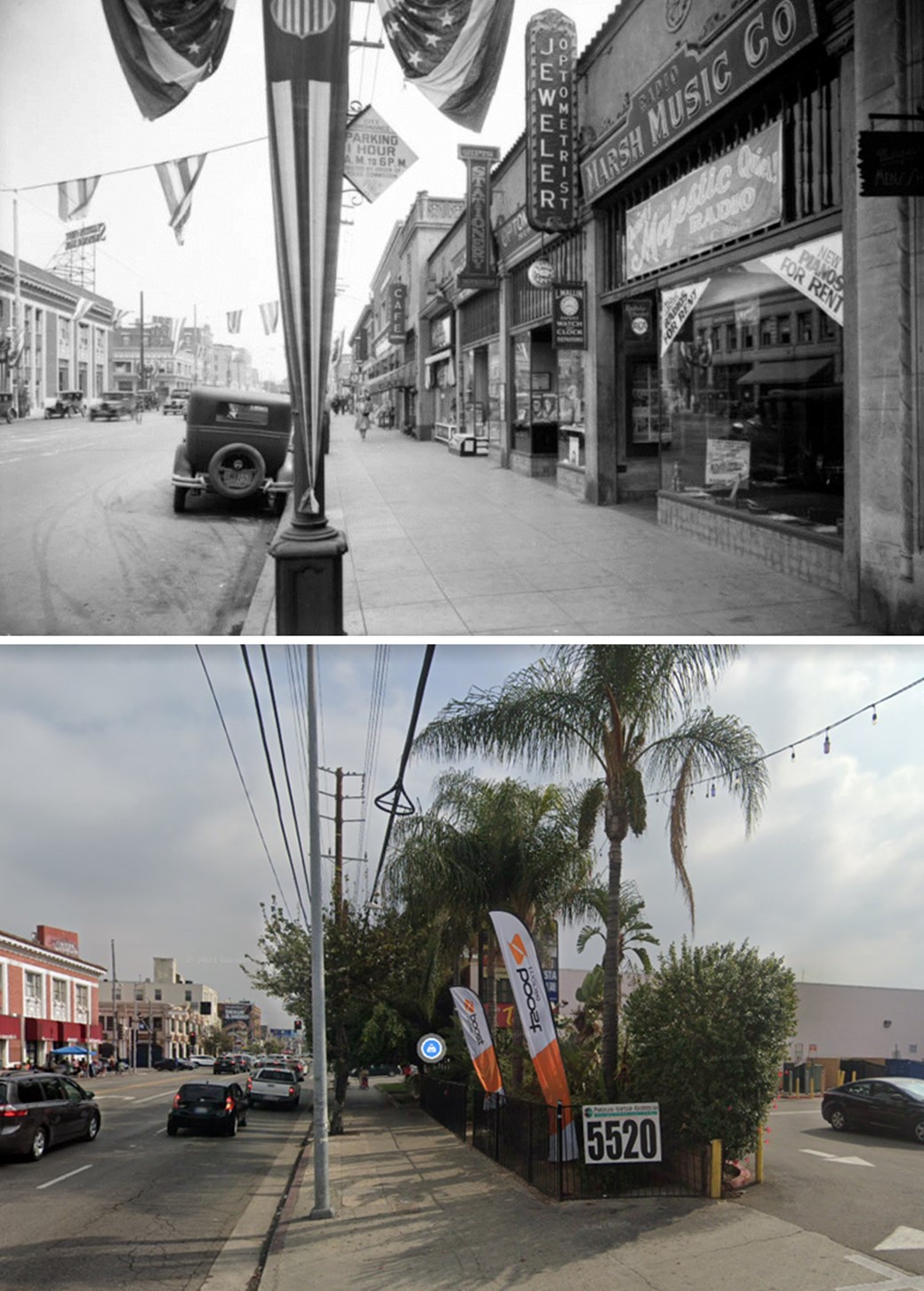
| (1930 vs 2021)* - Looking east on Santa Monica Boulevard toward Western Avenue with the Security Pacific Bank builiding located on the N/W corner. To the right is the Marsh Music Co. store at 5522 Santa Monica Boulevard, today the location of a strip mall. Note: In 1936, Route 66 was extended along this portion of Santa Monica Blvd as it heads through to the City of Santa Monica. |
* * * * * |
Santa Monica and Highland
 |
|
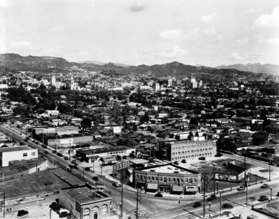
| (1920s)^^ - Panoramic view of Hollywood looking northeast from Santa Monica Boulevard and Highland Avenue. The Hollywood State Bank and the Standard Fence Company are visible in the foreground to the left along the boulevard to the other side of which is a Shell Gas Station and other commercial buildings. |
* * * * * |
 |
|
| (1922)* - View of Wilcox Avenue in Hollywood, with curbs on the street and houses built along it. |
 |
|
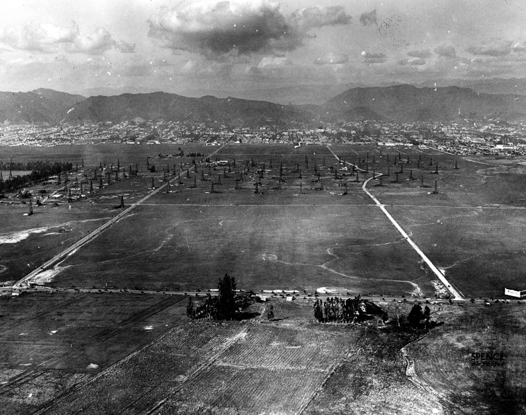
| (1922)* - Aerial view looking north of Wilshire at La Brea. Oil wells may be seen throughout the area while Hollywood and the Hollywood HIlls can be seen in the distance. |
 |
|
| (1922)^ - Aerial view of Santa Monica Boulevard looking northeast from Sherman (now, West Hollywood). The buildings in the bottom-left stand at the present-day site of the Pacific Design Center. Santa Monica Boulevard runs left-right, intersecting with Holloway Drive at roughly the center of the photograph. Hollywood is visible in the top-right. |
Historical Notes During the final decade years of the nineteenth century, the first large land development in what would later become West Hollywood—the town of "Sherman"—was established by Moses Sherman and his partners of the Los Angeles and Pacific Railway, an interurban railroad line which later became part of the Pacific Electric Railway system. Sherman became the location of the railroad's main shops, railroad yards, and "car barns". Many working-class employees of the railroad settled in this town. It was during this time that the city began to earn its reputation as a loosely regulated, liquor-friendly (during Prohibition) place for eccentric people wary of government interference.*^ |
 |
|
| (ca. 1928)^^ - Aerial view showing the area around the intersection of Santa Monica Boulevard and San Vicente Boulevard. In the foreground at center is a compound consisting of several large rectangular buildings very close together. In the foreground at right is a large dirt arena and a stable housing the Los Angeles Riding Academy. In the middle ground is a city composed of many densely packed, small buildings along broad streets. What appears to be a railroad yard is at center. In the background is a mountain range with several roads leading up the slopes. Streets in view are Sunset Boulevard, Holloway Drive, La Cienega Boulevard, Santa Monica Boulevard, Melrose Avenue, San Vincente Boulevard, Beverly Drive, and 3rd Street. The Gold Seal Dairy and the Cedars Sinai Hospital site can be seen as well. |
Historical Notes Despite several annexation attempts, the town elected not to become part of the City of Los Angeles. In a controversial decision, in 1925 Sherman adopted "West Hollywood", "...a moniker pioneered earlier in the decade by the West Hollywood Realty Board" as its informal name, though it remained under the governance of Los Angeles County.*^ |
 |
|
| (n.d.)* - Residential neighborhood near Santa Monica Blvd. and Gardner Ave. A house with greenery on each side is in the foreground and the background shows additional houses, trees and open spaces. |
 |
|
| (1924)* - View of Hollywood, looking southwest from Gardner Avenue, just from above Hollywood Boulevard. An orchard field is surrounded by residential homes. |
 |
|
| (1923)##++ – Aerial view showing where Laurel Canyon Rd emerges from the Hollywood Hills into West Hollywood. Laurel Canyon isn’t the curving road in the middle of the shot, but the one trailing out of the hills on the right. Sunset Boulevard is at lower-left. |
 |
|
| (1924)* - Aerial view of West Hollywood in 1924, with Sunset Boulevard at Kings Road in center. |
Bryn Mawr
 |
|
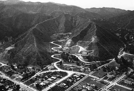
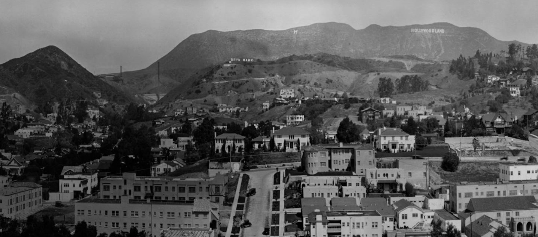
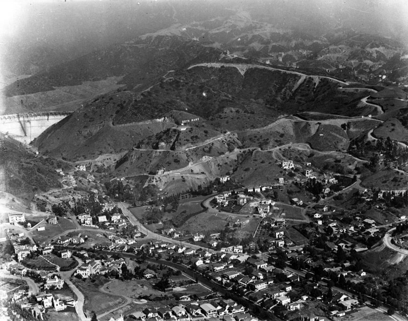
| (1924)* – Panoramic view looking north showing the Hollywood Hills with several large signs on display. The “Hollywoodland” Sign is in the upper-right, a large letter “H” is at top-center, and just below it and to the left can be seen a sign reading “Bryn Mawr”. At center-left is the new Mulholland Dam, still under construction. |
Historical Notes Similar to the “Hollywoodland” sign, the "Bryn Mawr" sign was put up to advertise a new housing development below and around the Mulholland Dam (completed Dec. 1924) in the Hollywood Hills. The development was owned by George Newberger and developed by R.W. Neiswendler. A 1925 LA Times article brags of home lots with views of Catalina, Long Beach and Venice, and Hollywood at night like a "twinkling like a sea of stars" and by day a "beautiful garden".* |
 |
|
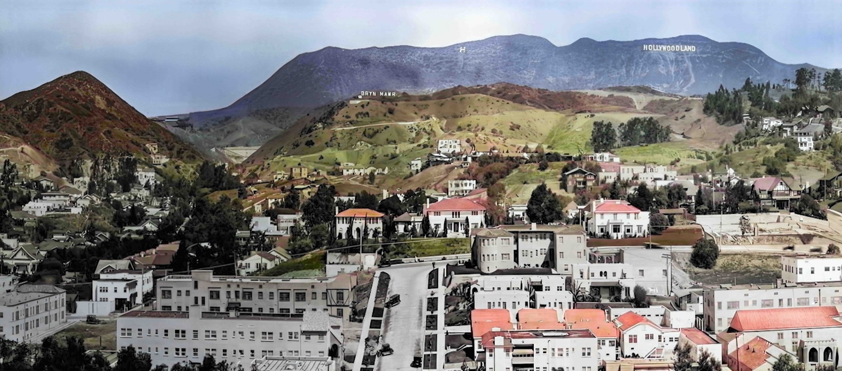
| (1924)* – Panoramic view looking north showing the Hollywood Hills with several large signs on display. The “Hollywoodland” Sign is in the upper-right, a large letter “H” is at top-center, and just below it and to the left can be seen a sign reading “Bryn Mawr”. At center-left is the new Mulholland Dam, still under construction. Image enhancement and colorization by Richard Holoff. |
Historical Notes The name "Bryn Mawr" in Los Angeles originated from an estate near Dolgellau in Wales that belonged to Rowland Ellis, a Welsh Quaker who emigrated to Pennsylvania in 1686 to escape religious persecution. The town was initially known as Humphreysville, named after early settlers of the Humphreys family, but it was later renamed Bryn Mawr by railroad agent William H. Wilson after acquiring the land for the railroad in 1869. The name "Bryn Mawr" means 'big hill' in Welsh, reflecting the hilly terrain of the area where it is locate. |
 |
|
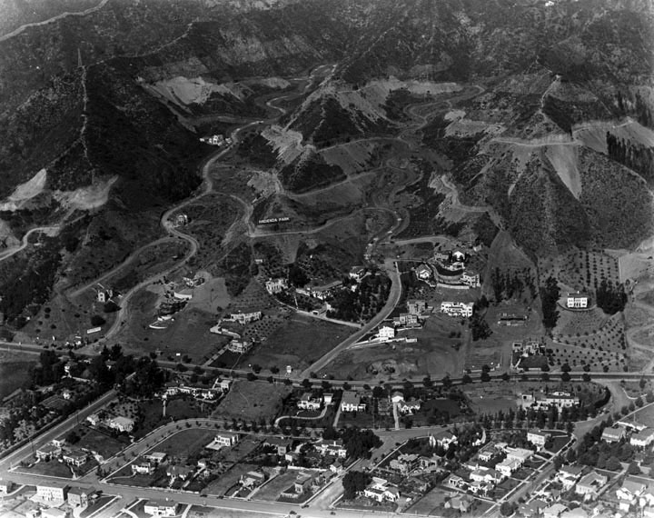
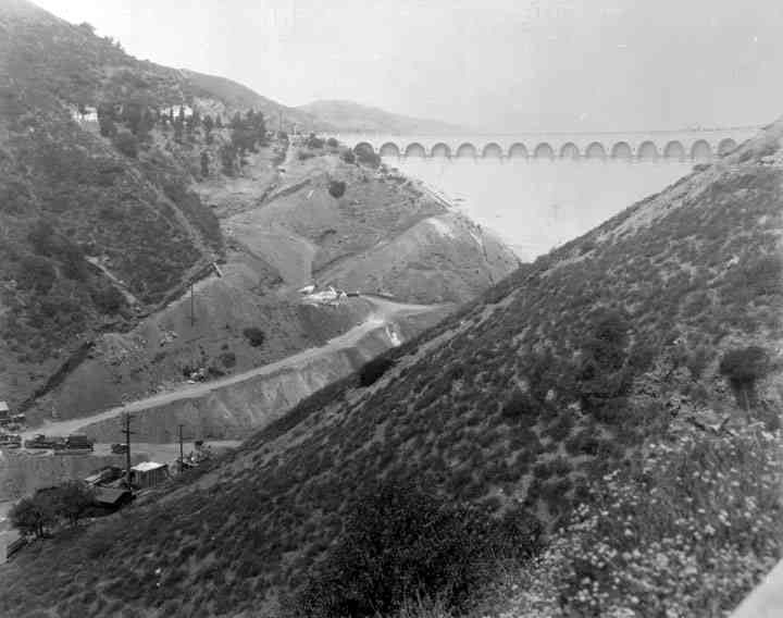
| (1924)* - Aerial view showing a nearly completed Mulholland Dam at the upper-left with the Bryn Mawr residential subdivision below it. The "Bryn Mawr" sign can be seen to the right of the dam on the hillside. |
 |
|
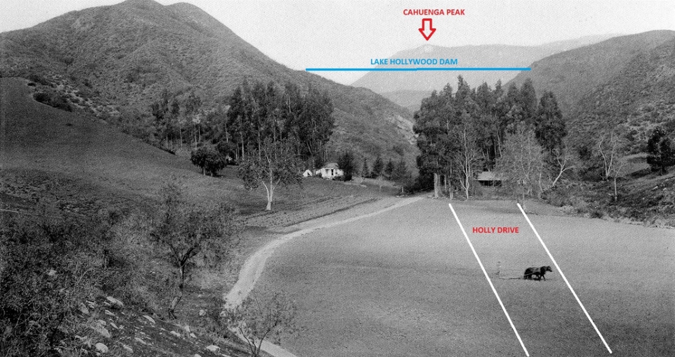
| (ca. 1905)^^ - View as seen from Cahuenga Blvd looking down at a farm with man behind a horse-drawn plow. Today, Holly Drive runs north in this area surrounded by a 1920s-built tract of homes (Bryn Mawr). Also seen in the distance is Cahuenga Peak and the future location of 1925-built Lake Hollywood Dam (aka Mulholland Dam). |
 |
|
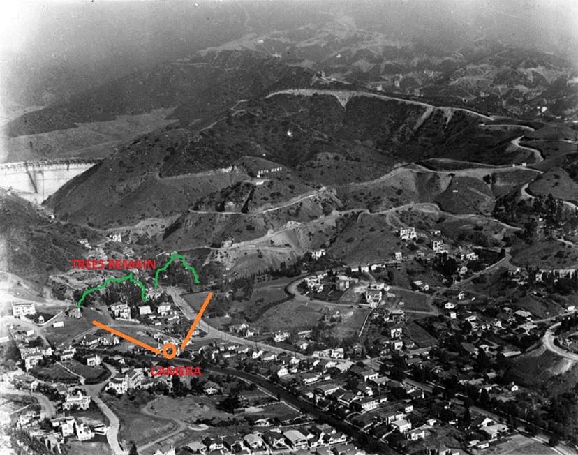
| (1924)* - Aerial view showing location where the previous photo was taken. The highlighted trees act as a good reference point for comparison. |
Mulholland Dam and Hollywood Reservoir
 |
|
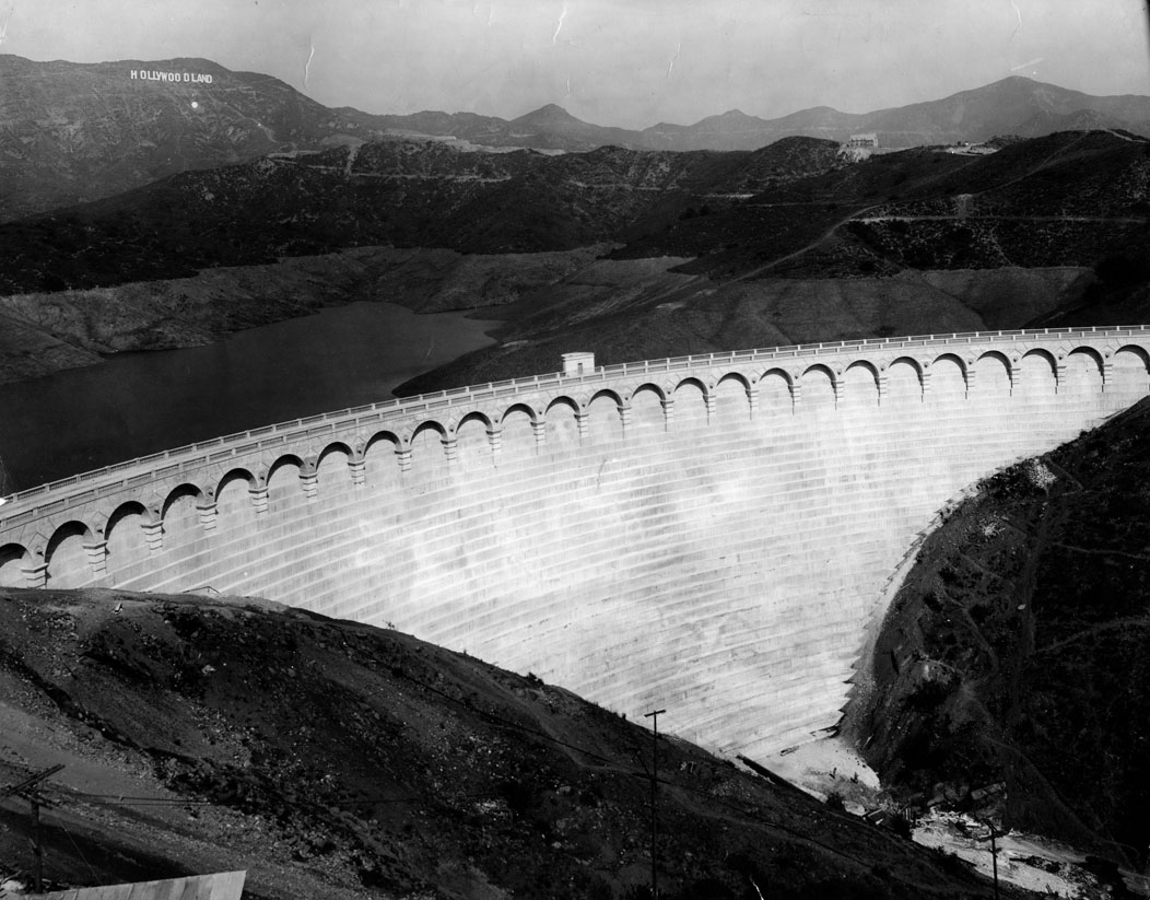
| (1925)#^^* - View of Mulholland Dam shortly after it was completed. It was named after the designer William Mulholland, who was also responsible for the design of the aqueducts and reservoirs for Los Angeles. |
Historical Notes The Mulholland Dam was built between August 1923 and December 1924 in the Hollywood Hills. It is a concrete-arched gravity dam constructed for the sole purpose of creating a water reservoir for the City of Los Angeles. It was built under the supervision of William Mulholland, chief engineer for the City's Bureau of Water Works and Supply (later DWP). |
 |
|
| (1920s)* - Front view of Mulholland dam in the Hollywood Hills, the most beautiful of a score of storage basins in Los Angeles' water system. The HOLLYWOODLAND Sign can be seen in the background. |
Historical Notes The reservoir formed behind the dam was called the Hollywood Reservoir (later Lake Hollywood) and would hold up to 2.5 billion gallons of water from the Owens River Aqueduct System (LA Aqueduct) and from the groundwater of the San Fernando Valley. |
.jpg) |
|
| (1930s)*^#* – Postcard view showing the Mulholland Dam in the Hollywood Hills. Note how the front of the dam was filled in with dirt for additonal reinforcement (compare to previous photo). |
Historical Notes The Mulholland Dam was reinforced with tons of earth on the downstream side as a precaution after the similar St. Francis Dam burst in 1928. Later studies confirmed that the St. Francis Disaster was not caused by a faulty design. |
Click HERE to see more in Mulholland Dam and Hollywood Reservoir |
* * * * * |
East Hollywood
 |
|
| (1923)* - Looking west from Olive Hill, down Hollywood Boulevard on the East side of Hollywood in what appears to be a residential area. |
Historical Notes The famous street was named Prospect Avenue from 1887 to 1910, when the town of Hollywood was annexed to the city of Los Angeles. After annexation, the street numbers changed from 100 Prospect Avenue, at Vermont Avenue, to 6400 Hollywood Boulevard.*^ |
 |
|
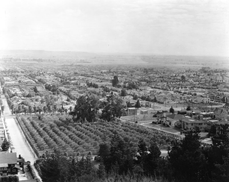
| (ca. 1920s)* - Panoramic view of a residential area in East Hollywood in the early 1920s, looking southwest from Sunset Boulevard and Edgemont Street. In the foreground are the olive trees of Olive Hill. Today, Kaiser Permanente Hospital stands at this corner. |
Historical Notes Olive Hill is located in the East Hollywood district. Barnsdall Park sits on top of Olive Hill near the intersection of Hollywood and Vermont, and is home to the famous Hollyhock House that was designed in the 1920's by the internationally acclaimed architect Frank Lloyd Wright. |
 |
|
| (1928)* - View looking north from Olive Hill showing a residential area in East Hollywood with the Hollywood Hills in the background. The tallest peak (top left) is Mt. Hollywood, near where the Griffith Park Observatory would be built in 1933. |
 |
|
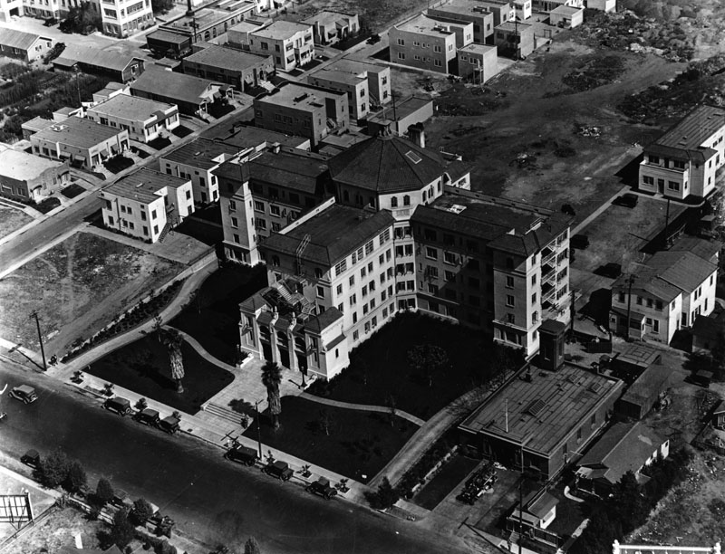
| (ca. 1925)* - Aerial view of Hollywood Presbyterian Hospital, located at 1300 North Vermont Avenue. There is a fire station at right, and open space is seen at left and behind the hospital. Duplexes and apartment buildings are seen as well, and possibly a nursery growing ground at left. |
Historical Notes Hollywood Presbytarian Hospital was founded as Hollywood Hospital in 1924. It was later known as Queen of Angels-Hollywood Presbyterian Medical Center. In 2004, it was sold to the CHA Medical Group of South Korea for $69 million.^* |
* * * * * |
Please Support Our CauseWater and Power Associates, Inc. is a non-profit, public service organization dedicated to preserving historical records and photos. Your generosity allows us to continue to disseminate knowledge of the rich and diverse multicultural history of the greater Los Angeles area; to serve as a resource of historical information; and to assist in the preservation of the city's historic records.
|
More Historical Early Views
Newest Additions
Early LA Buildings and City Views
History of Water and Electricity in Los Angeles
* * * * * |
References and Credits
* LA Public Library Image Archive
^*California Historic Landmark Listing (Los Angeles)
^ California Historical Society Digital Archive
**Retronaut - Hollywoodland Sign
^#Selig Film News - Hollywoodland Sign
***The Story of Hollywood by Gregory Paul Williams
**^Table Magazine: LA Observatory
^**Huntington Digital Library Archive
**+Hollywood Renegades Archive: "The Lot"
^^*Cinema Treasures: Granada/Oriental Theater
^##The Los Angeles Travel Guide: Hollywood Architecture
##*The Daily Mirror: Garden Court Apartments; Security Trust and Savings Bank
**#Daily News: Hollywood Sign Celebrates its 90th Birthday
*^*MTA Transportation and Research Library Archives
^v^Discover Los Angeles: The Story of An LA Icon
*^^*Vintage Los Angeles - Facebook.com: Bernheimer Japanese Mansion
*^#*Calisphere: University of California Image Archive
*^#^Hollywood High School – National Register of Historic Places Application
^^**Flickr.com: Floyd Bariscale - Sunset Bowling Center
**##MartinTurnbull.com: Judy Garland; Warner Bros Studios
#**#Facebook.com: Garden of Allah Novels, Martin Turnbull
##++Pinterest.com: Historical and Vintage Photos of Los Angeles and Hollywood
#^^*DWP - LA Public Library Image Archive
##^#LAist.com: Why Vine Becomes Rossmore
*#*#Facebgook.com - Great Photos from Los Angeles' Past: Hollywoodland Sign
^*^#Facebook.com - Bizarre Los Angeles
^##*Flickr.com: Michael Ryerson
^#**A Brief Egyptian Theatre History
^#*^Flickr.com: espensorvik: Hollywood High School Mural
**^*^Pacific Coast Architecture Database; Bard's Hollywood Theatre (Vista Theatre)
^^^##Sunset Bronson Studios: Hudson Pacific Properties
^###*Big Orangle Landmarks: Warner Bros
*# Skyscraperage.com. - Griffith Observatory; Hollywoodland Sign; Oriental Theater; "It" Cafe; Aerial of Burbank and Hollywoodland Sign; Pickford-Fairbanks Studio Lot; Shakespeare Bridge; Prospect Studios; Byrn Mawr; Outpost Sign
*^ Wikipedia: Hollywood; Hollywood Athletic Club; Hollywood Bowl; Grauman's Chinese Theatre; Grauman's Egyptian Theatre; Pantages Theatre (Hollywood); John Hanson Ford Theatre; 20th Century Fox; Samuel Goldwyn.Studio; Barnsdall Art Park; Greek Theatre; Griffith Observatory; Cinerama Dome; Ralphs; Hollywood Palladium; Hollywood and Vine; Hollywood Masonic Temple; Hollywood Pacific Theatre; Max Factor; West Hollywood; Brown Derby; Hollywood Christmas Parade; Clara Bow; Decoration Day; Charlie Chaplin Studios; Metro Studios; Old Warner Bros. Studio; Lasky-DeMille Barn; Typewriter; Prospect Studios; Broadway-Hollywood
< Back