Early Views of Pasadena
Historical Photos of Early Pasadena |
 |
|
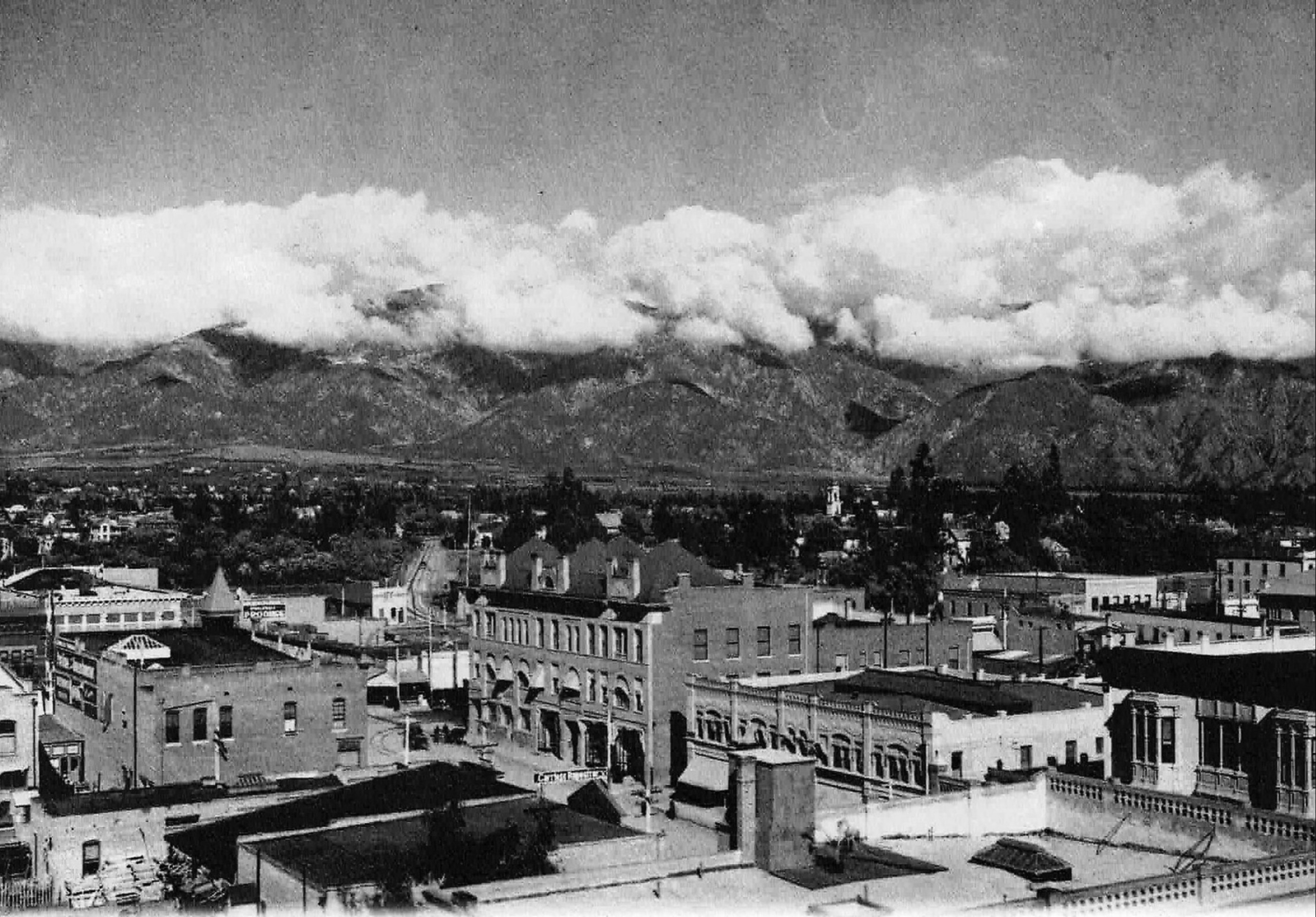
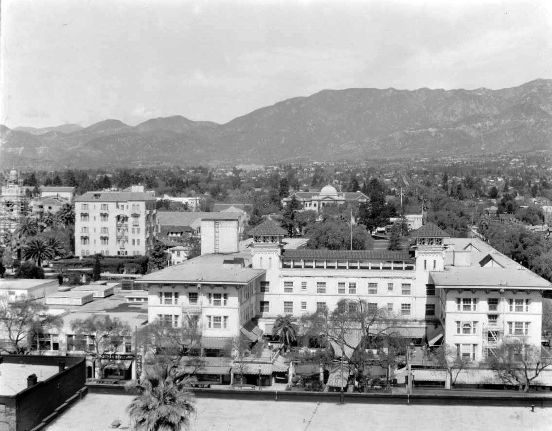
| (ca. 1904)* – Looking north towards the San Gabriel mountains as seen from one of the upper floors of the Green Hotel. |
 |
|
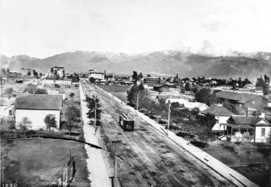
| (ca. 1905)^ – View of Raymond Avenue looking north as seen from the intersection of Raymond and Colorado. A streetcar is in the middle of the image while the Green Hotel is seen in the distance. The beautiful San Gabriel Mountains stand in the far background. |
Colorado and Fair Oaks
 |
|
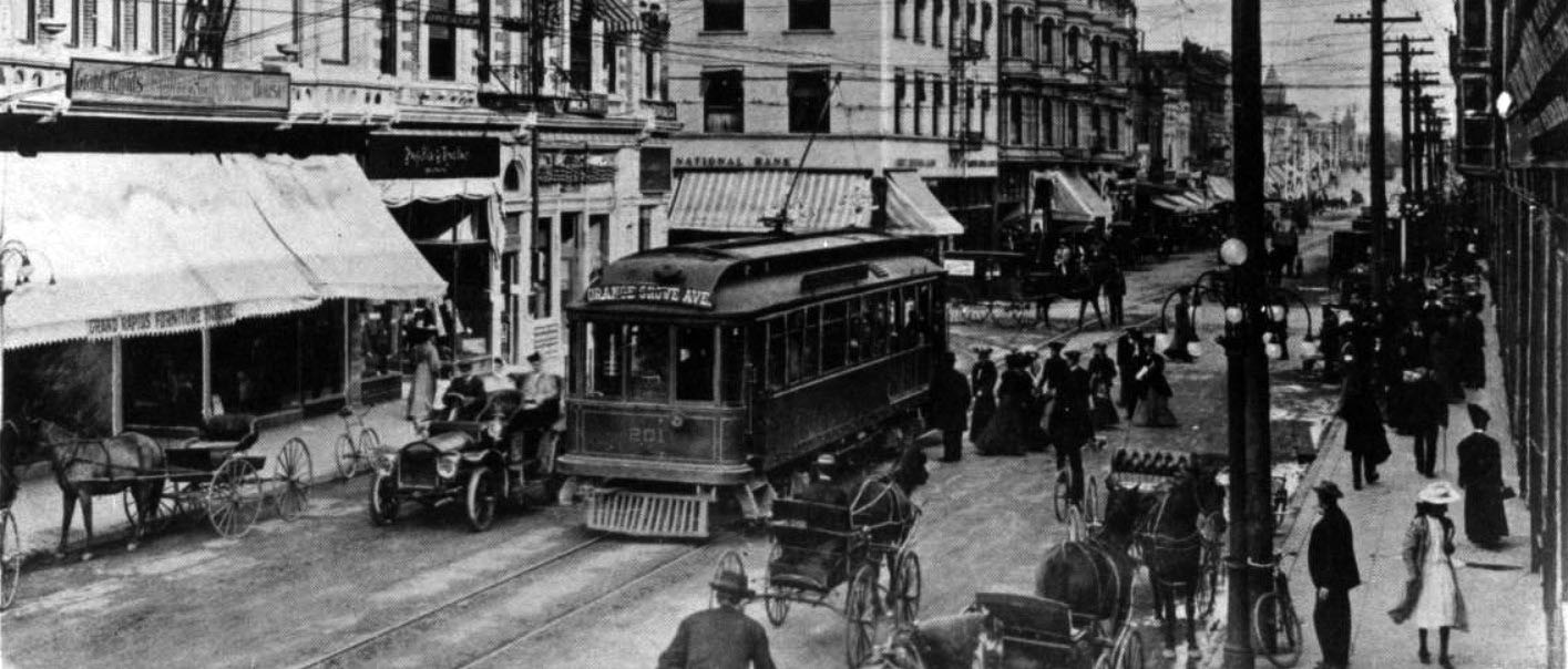
| (ca. 1905)^ – A Pacific Electric car on Colorado Street near Fair Oaks Avenue in Pasadena stops for passengers. The car was on the West Colorado Street-Orange Grove Avenue line. |
 |
|
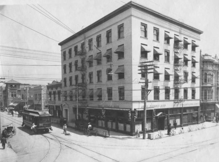
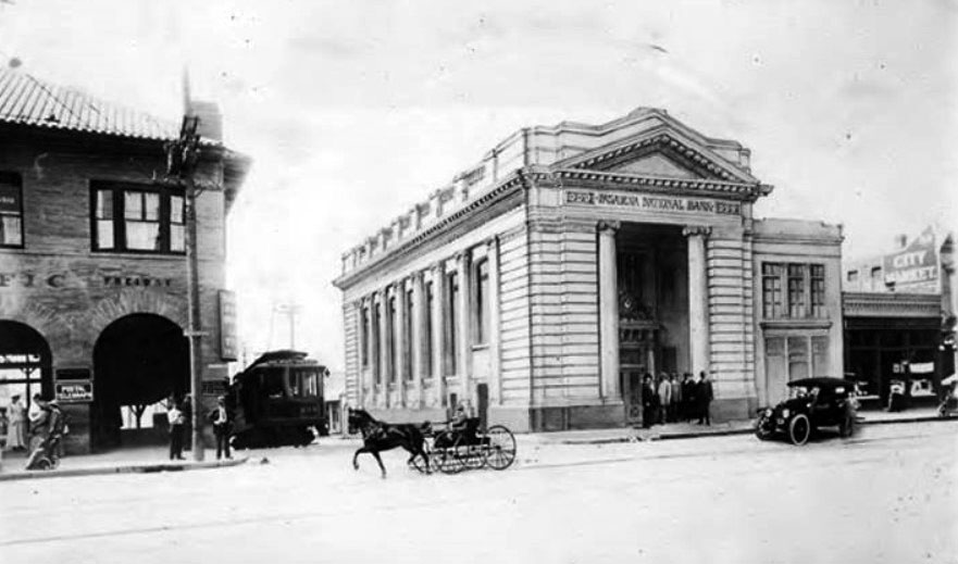
| (1906)** - Looking toward the northeast corner of Colorado and Fair Oaks showing the First National Bank. More bicycles are seen parked by the curb in front of the building than horse-drawn carriages. A woman is boarding a stopped electric streetcar on the left. |
 |
|
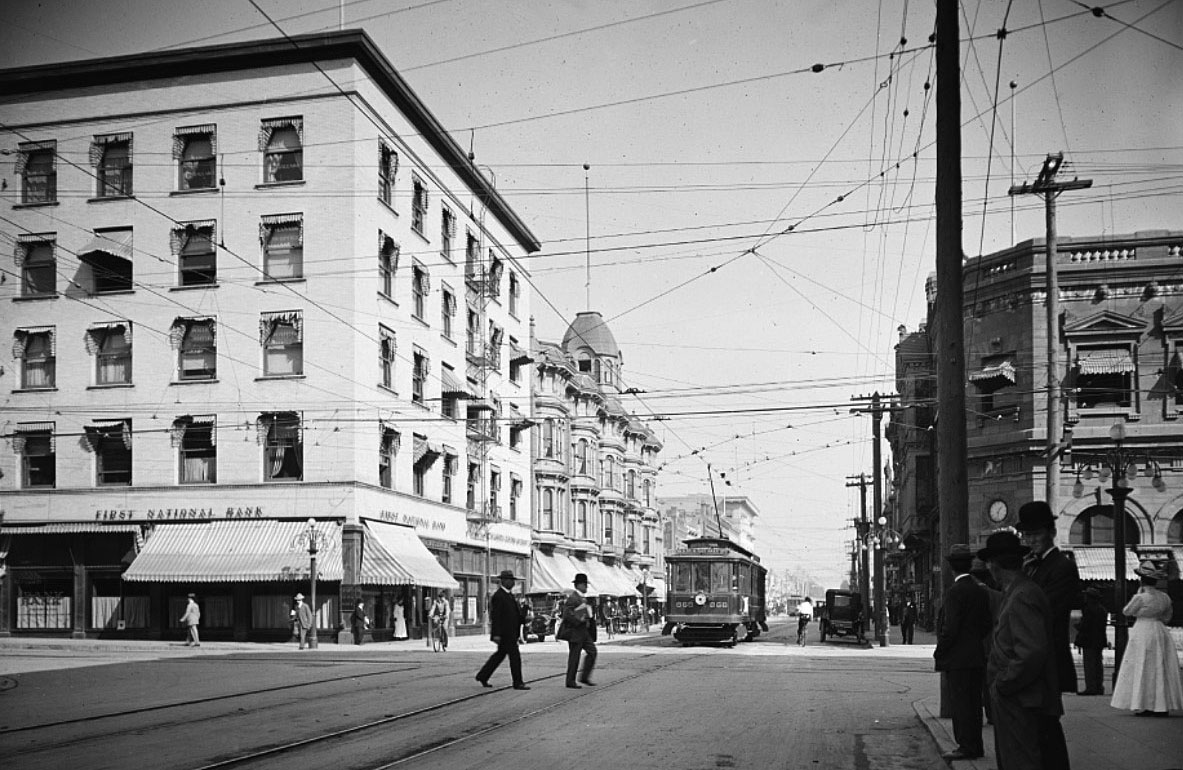
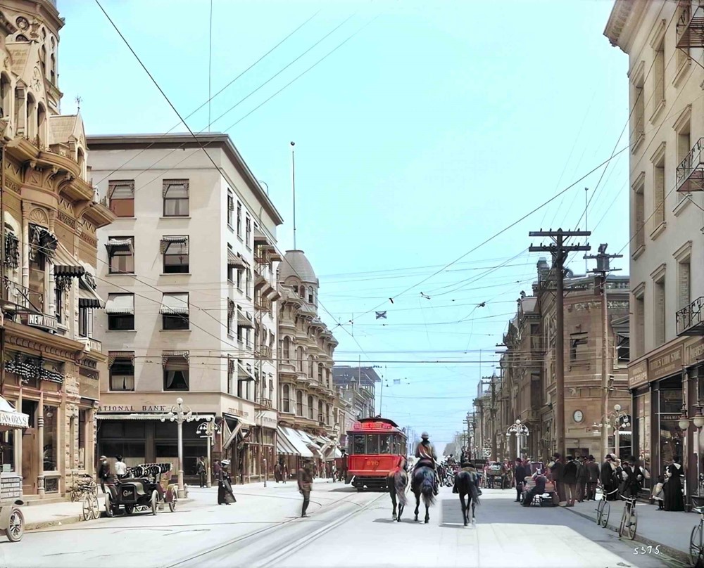
| (ca. 1907)# – View looking east on Colorado Street at Fair Oaks Avenue. First National Bank is on the ground floor of the building on the NE corner (left). |
 |
|
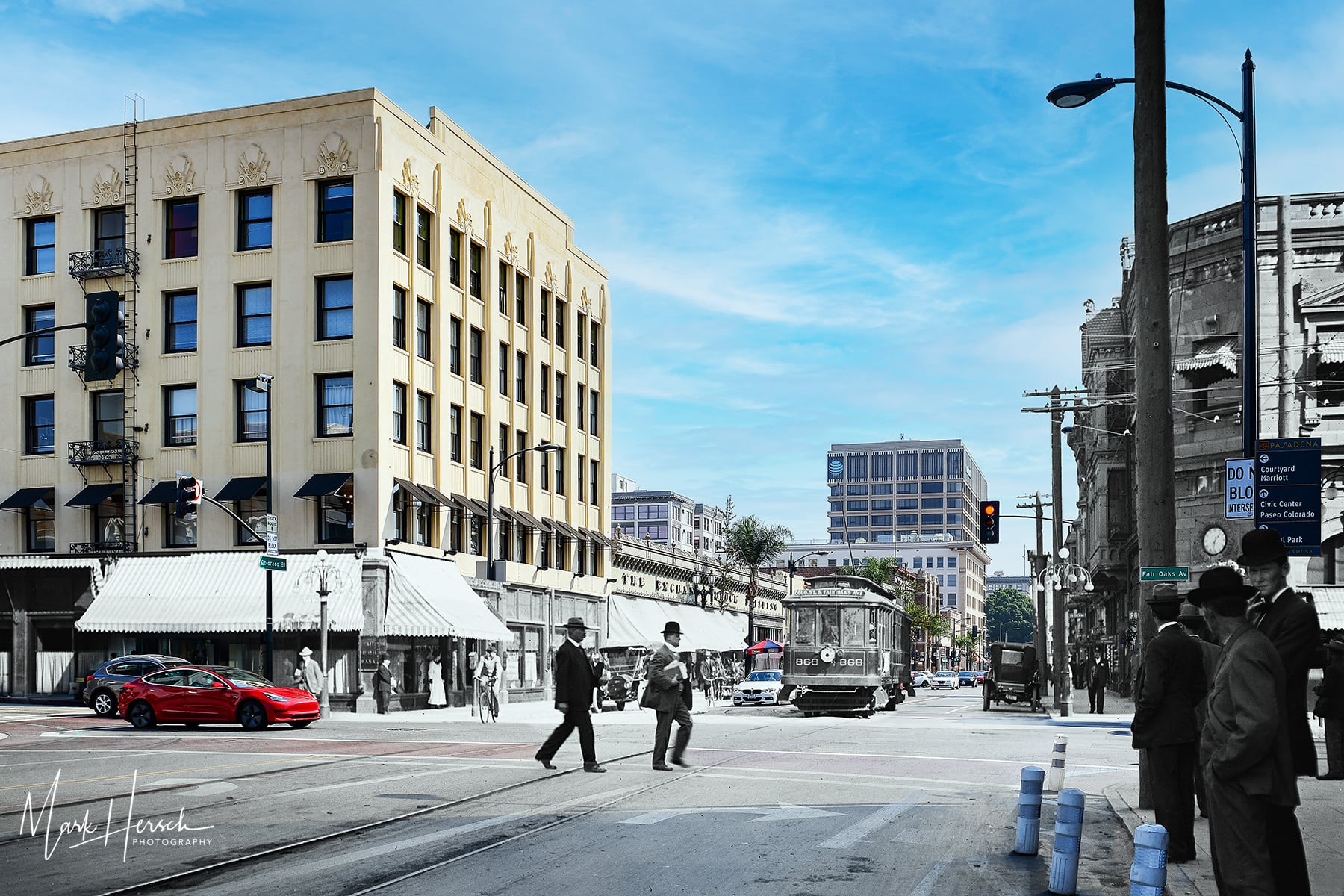
| (1907 - 2020)* - Compositied image showing Colorado Blvd. looking east at Fair Oaks Ave. Photo by Mark Hersch |
Then and Now
 |
|
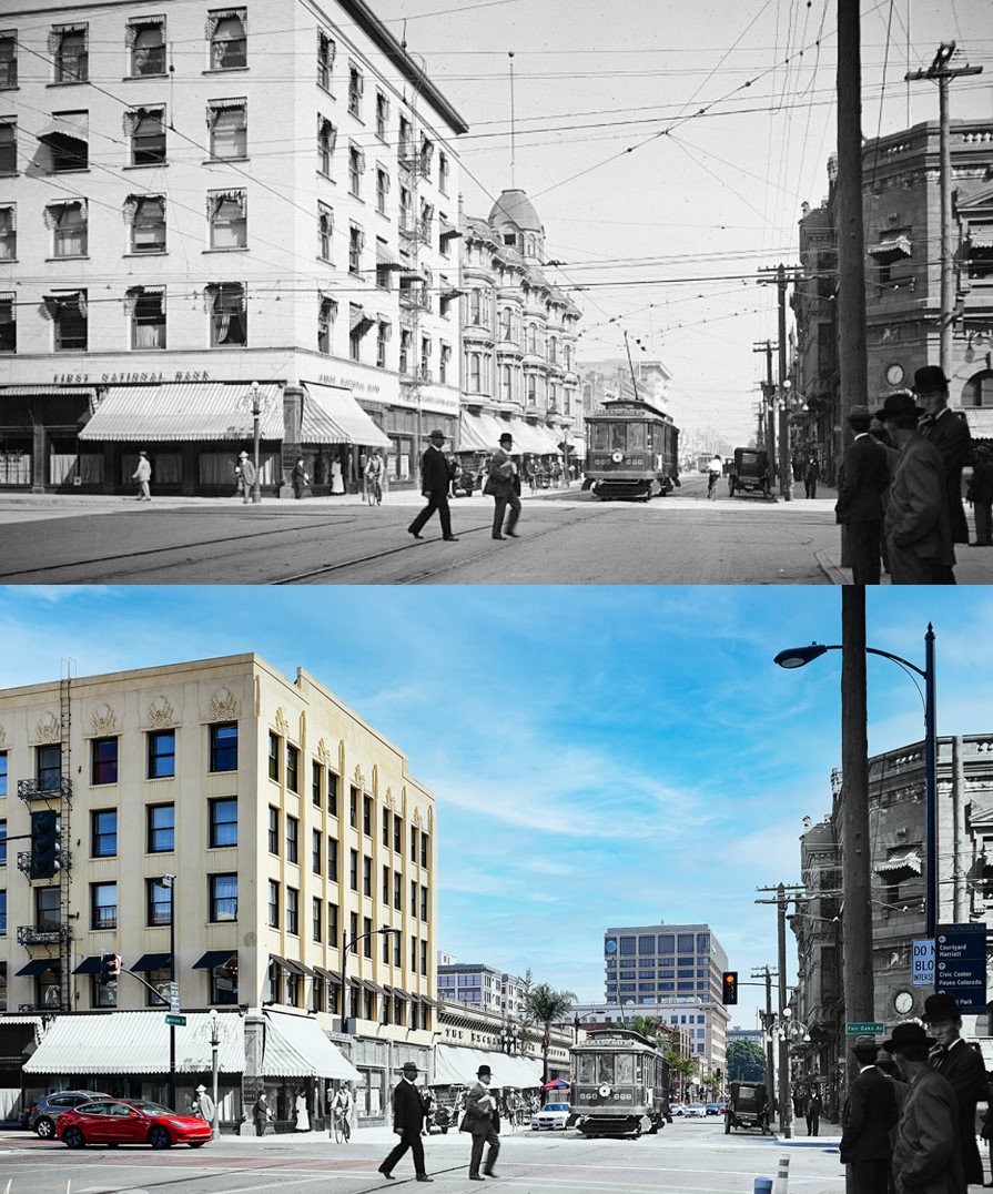
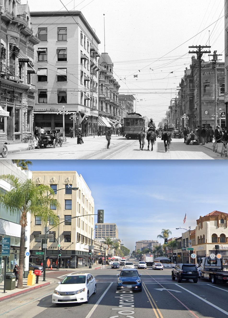
| (1907 v. 2020) - Colorado St. looking east at Fair Oaks in Pasadena. Bottom photo is a composited image blending a 1907 view with one that’s more current. Composite image by Mark Hersch. |
 |
|
| (ca. 1907)^ - Looking east on Colorado at Fair Oaks. Early model cars and bicycles are parked by the curb while a streetcar, horses, and pedestrians are seen on the road. |
 |
|
| (ca. 1907)^ - Looking east on Colorado at Fair Oaks. Photo by C.C. Pierce; AI image enhancement and colorization by Richard Holoff |
Then and Now
 |
|
| (1907 v. 2022) - Colorado Street looking east at Fair Oaks Avenue. |
Colorado and Broadway (Now Arroyo Parkway)
 |
|
| (ca. 1907)** - View of Pasadena National Bank Located at the corner of Colorado and Broadway (Now Arroyo Parkway). A horse-drawn carriage passes by an electric streetcar, while an early model car is seen parked in front of the bank. |
South Pasadena High School
 |
|
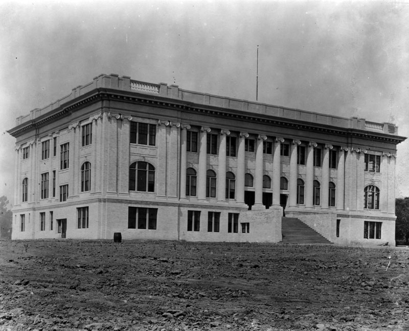
| (1907)* - Exterior view of the Classical Revival style building of South Pasadena High School, taken not long after the building was completed. |
Historical Notes The City of South Pasadena established a solid reputation for its public schools, its first high school being no exception. Norman Foote Marsh, and his firm Marsh and Russell, designed this first High School building in 1906, and saw its completion by 04/1907. The City of South Pasadena, in its historic preservation context statement said of this education complex: "After several years of operating out of shared or rented facilities, a bond was passed in 1906 which authorized $65,000 for the construction of a new high school. However, construction was delayed when the San Francisco earthquake in 1906–along with the subsequent rebuilding efforts–inflated the cost of building materials. Voters were compelled to approve an additional $10,000 before construction could begin. Designed by the firm of Marsh & Russell, the three-story building was officially opened in April 1907. Additional buildings housing domestic science and manual training programs were added in 1912.^ |
 |
|
| (1908)^#^^ – Postcard view showing South Pasadena High School. Two men are seen posing in the foreground. |
Historical Notes This building, constructed in 1907, and two others added in 1912 stood until the 1950s, at which time they were demolished. * |
* * * * * |
 |
|
| (ca. 1907)* - Exterior view of Lake Ave. Methodist Church on the southeast corner of Colorado and Lake Avenue, in Pasadena. |
 |
|
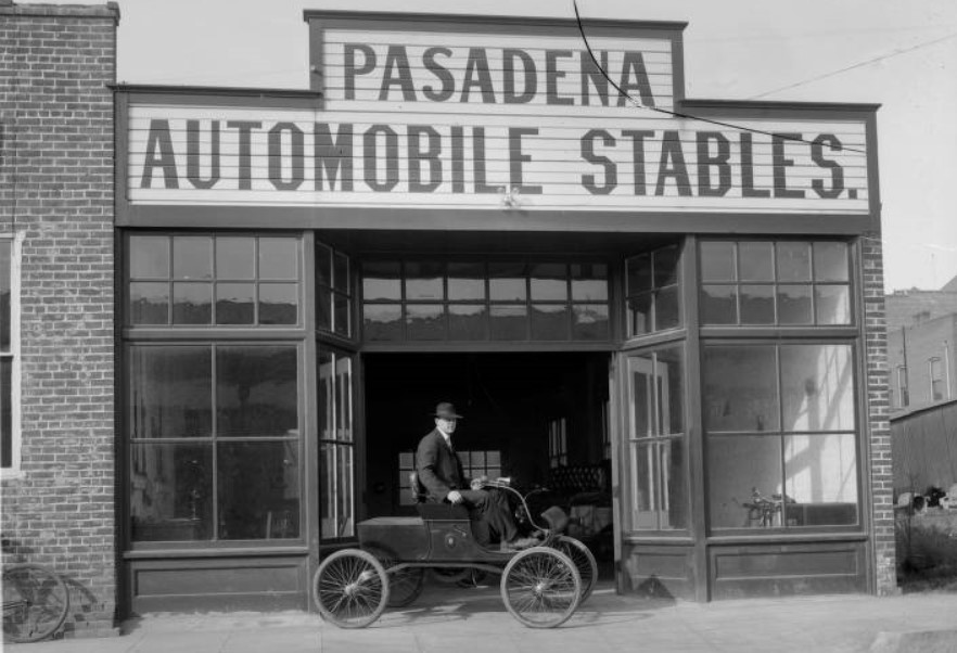
| (ca. 1908)#* - A street view of Pasadena Automobile Stables, with a man seated in a parked automobile in front of the open shop doors. The vehicle has no top or sides, and only has one padded bench for seats. |
 |
|
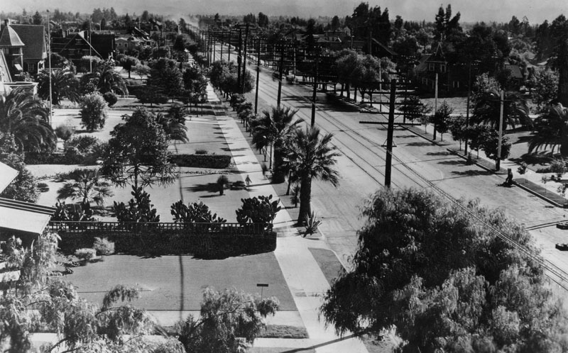
| (ca. 1900)*^* – View looking north on Los Robles Avenue from the Maryland Hotel located on Colorado Boulevard with John Muir Jr. High School visible in the background in the upper left corner of the photo. |
Historical Notes The large building seen in the upper left corner of the photo is John Muir Jr. High School, which later became Pasadena High School, located on Walnut St., between Euclid and Los Robles.*^* |
 |
|
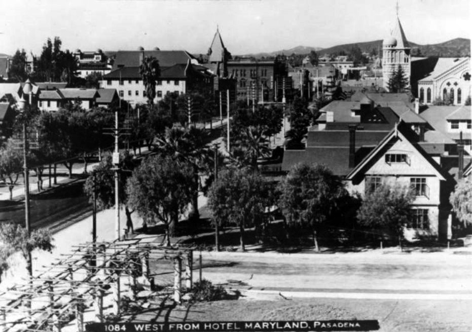
| (ca. 1903)*^* – View looking west from the Maryland Hotel. |
Historical Notes The trellis in the lower left hand corner was later covered in vines. The church in the upper corner of the photo is believed to be the Pasadena Presbyterian Church.*^* |
 |
|
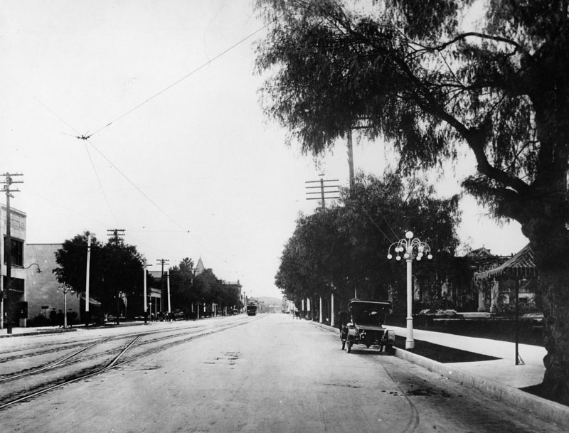
| (ca. 1908)* - Colorado Blvd. in Pasadena looking east from the Hotel Maryland circa 1908. The street is lined with houses, and streetcar tracks run down the middle. |
 |
|
| (1910)* - View of Colorado Blvd. in Pasadena looking west from the Maryland Hotel. Streetcar tracks and overhead wires are seen. Note the ornate streetlight on the right. Click HERE to see more in Early LA Streetlights. |
Hotel Maryland
 |
|
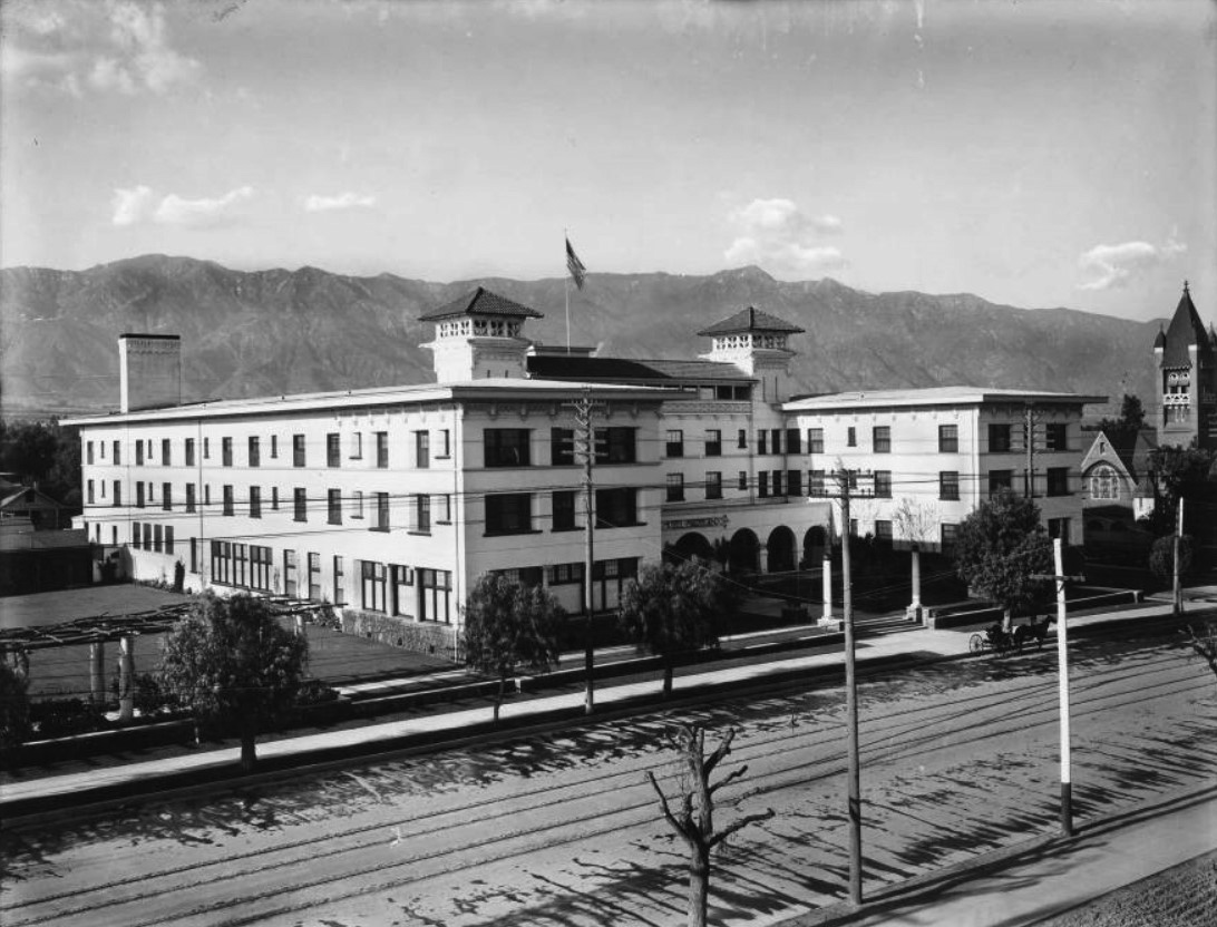
| (1903)*^* – View showing the newly constructed Hotel Maryland located at 411 East Colorado with San Gabriel Mountains in the background. A horse-drawn wagon is parked in front of the hotel. |
Historical Notes The Hotel Maryland was designed by John Parkinson and opened in 1903. It was expanded over the years and hosted many famous people including Presidents. |
 |
|
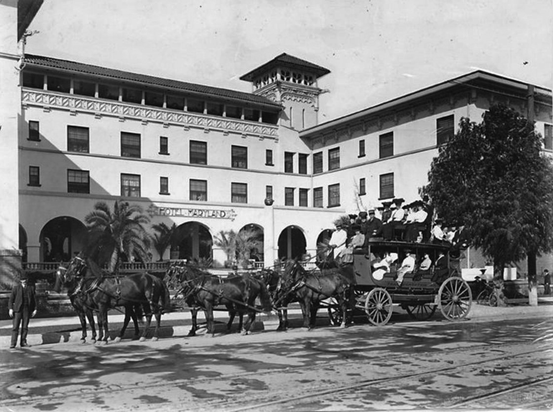
| (ca. 1903)*^* – View showing a tally-ho parked by the curb in front of the Maryland Hotel. |
Historical Notes The Maryland Hotel was an all year hotel, different from seasonal hotels. The builder of the Maryland's first unit was Colin Stuart, who named the hotel "Maryland", after his home state.* |
 |
|
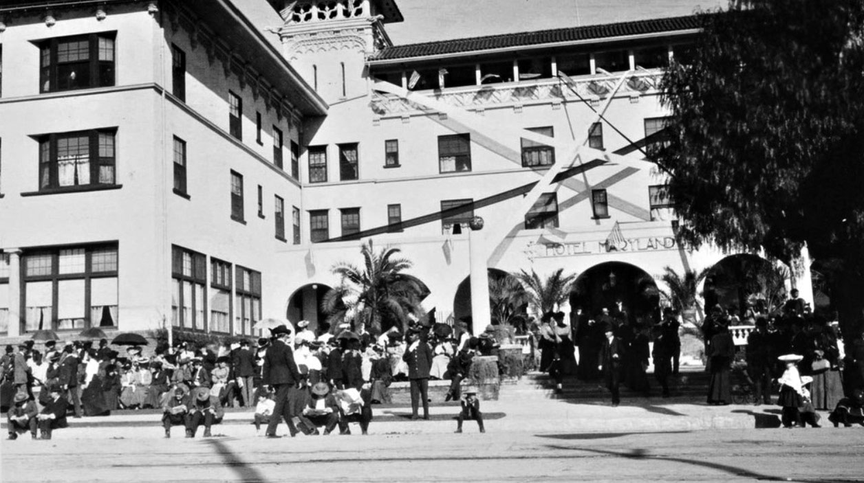
| (1905)^*# – View showing the front of the Maryland Hotel where crowds of people await the Rose Parade. |
 |
|
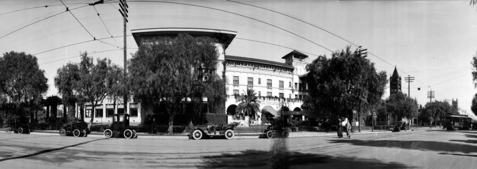
| (ca. 1910)*^* - Panoramic street view of the Hotel Maryland on East Colorado, between Euclid and Los Robles. There are several automobiles parked along the street, and an electric streetcar travels along the street on the right. |
 |
|
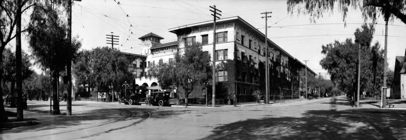
| (ca. 1913)*^* - Panoramic street view of the Hotel Maryland. Vines have overgrown the walls of the first two stories and stretch as far as the roof in places. Automobiles are parked on the street in front of the hotel, and cables run overhead for streetcars. |
Historical Notes On April 18, 1914, the main building burned to the ground. It was redesigned by Myron Hunt and rebuilt the same year. A large open area to the north was lined with "bungalows" and some people lived there all the time. |
 |
|
| (1927)++# - View looking north from the roof of the Pasadena Athletic Club on the corner of Los Robles and Green. The Maryland Hotel is seen across the street with its Annex (at left) which still stands at the northeast corner of Union and Euclid. At far left, City Hall is still being erected; note scaffolding. At center rear with distinctive dome is the Benjamin Franklin School on Walnut. |
Historical Notes At one time the Maryland Hotel covered the entire area from Colorado Blvd. to Walnut Avenue, with Los Robles as its eastern border and Euclid as its western border. Union Street wasn't put through until later, so it was a solid long block full of rental bungalows all the way north. |
 |
|
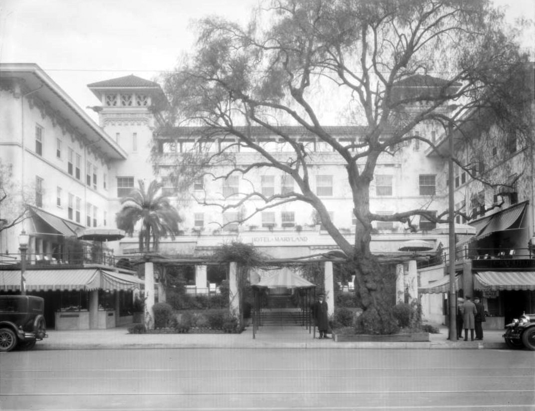
| (1927)*^* - Street view of the Hotel Maryland at 411 East Colorado. A doorman stands at the end of an awning on the sidewalk. |
Historical Notes The Maryland Hotel covered eight acres of lawn and flower gardens, and besides the main structure it had thirty bungalows, where one could live in quiet seclusion a few feet from the busy halls - yet remote and undisturbed - if he so desired.* |
 |
|
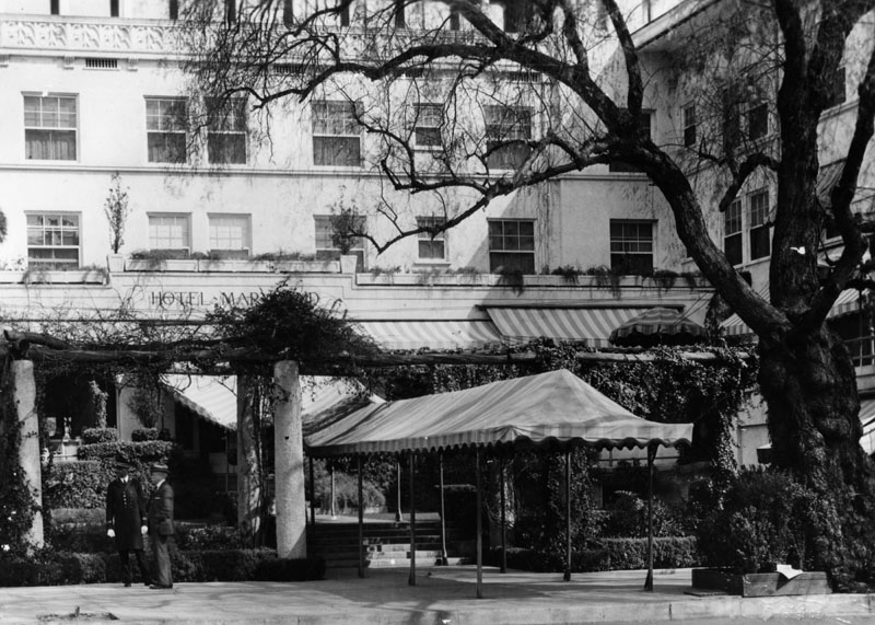
| (ca. 1930)* - Close-up view of front entry to the Maryland Hotel. A canopy stretches from the entrance of the hotel to the street. |
 |
|
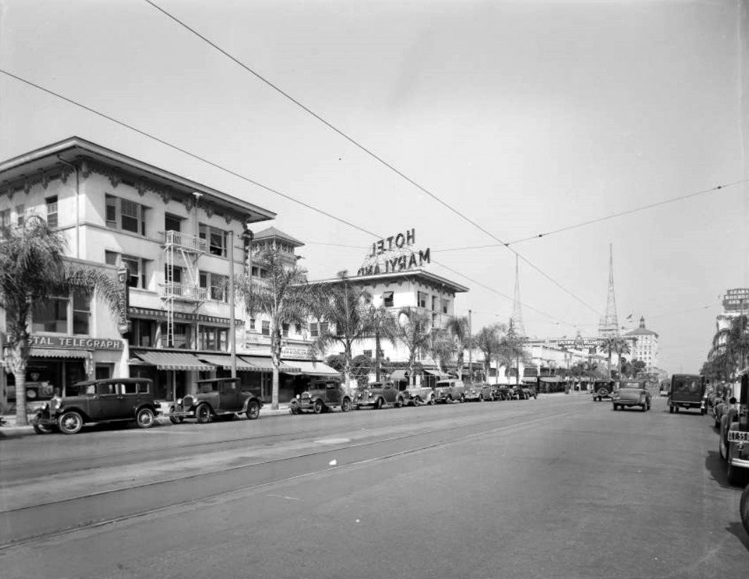
| (1937)*^* - Street view looking east showing the Maryland Hotel at 411 East Colorado. Other businesses on this stretch of Colorado include Postal Telegraph, Sherwin Williams Paints & Wallpapers, and Sears Roebuck & Co. |
.jpg) |
|
| (1937)++# - View looking west on Colorado at Los Robles showing the Hotel Maryland. Two men stand under an umbrella next to an open manhole in the middle of the street. |
Historical Notes Most of the Hotel Maryland was torn down shortly after August 20th, 1937 but some of the hotel continued until 1948. The property was gradually sold off. The apartment house on Euclid, added in 1927, is all that remains today. |
Maryland Apartments
 |
|
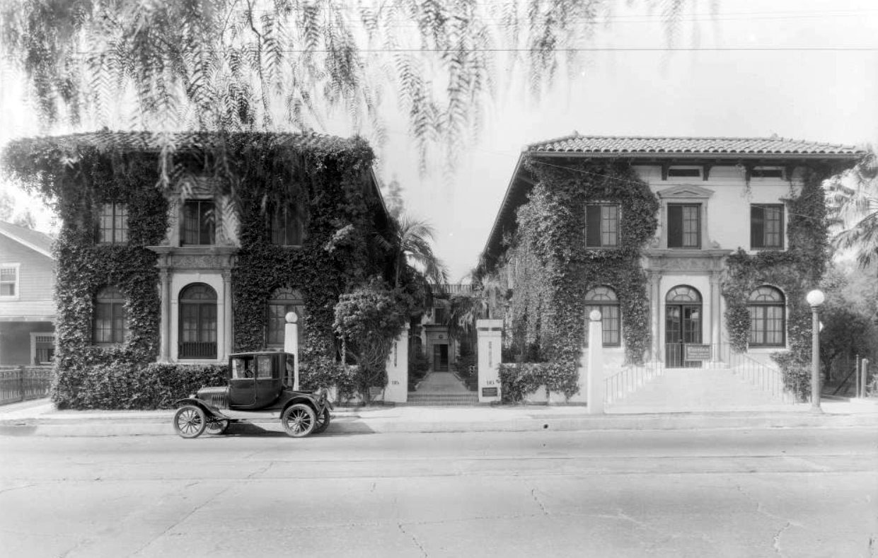
| (1924)*^* - Street view of the ivy-covered Maryland Apartments at 95 South Los Robles, with an automobile parked in front. On the right is a women's clothing shop called Flornina. |
 |
|
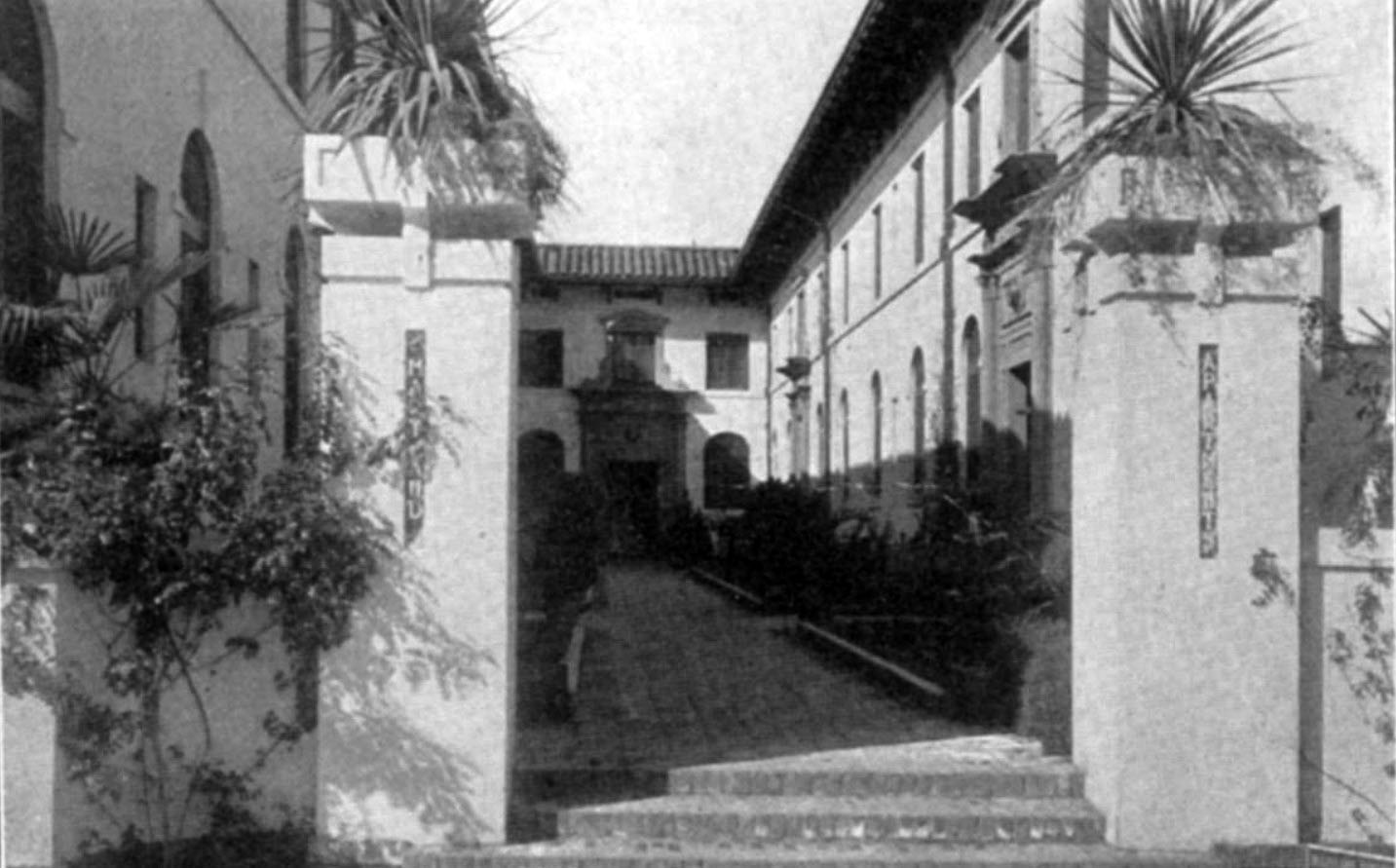
| (1918)*^* – Close-up view showing the front courtyard to the Maryland Apartments. |
Fair Oaks Market
 |
|
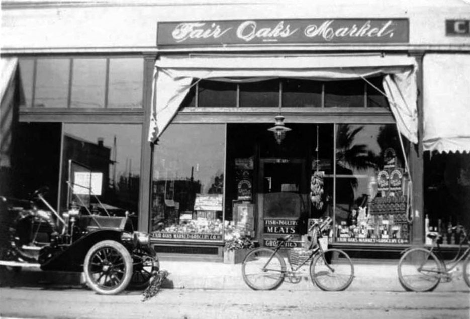
| (1909)*^* - View showing an early model car and two bicycles parked in front of Fair Oaks Market located at 139 North Fair Oaks. W. H. Stone, Jr. was the proprietor. |
William J. Dean Co. Grocery
 |
|
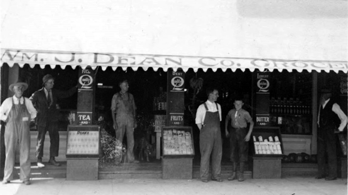
| (ca. 1910s)** – View showing the William J. Dean Co. Grocery Story located on the north side of Colorado Street west of Fair Oaks Avenue. |
* * * * * |
 |
|
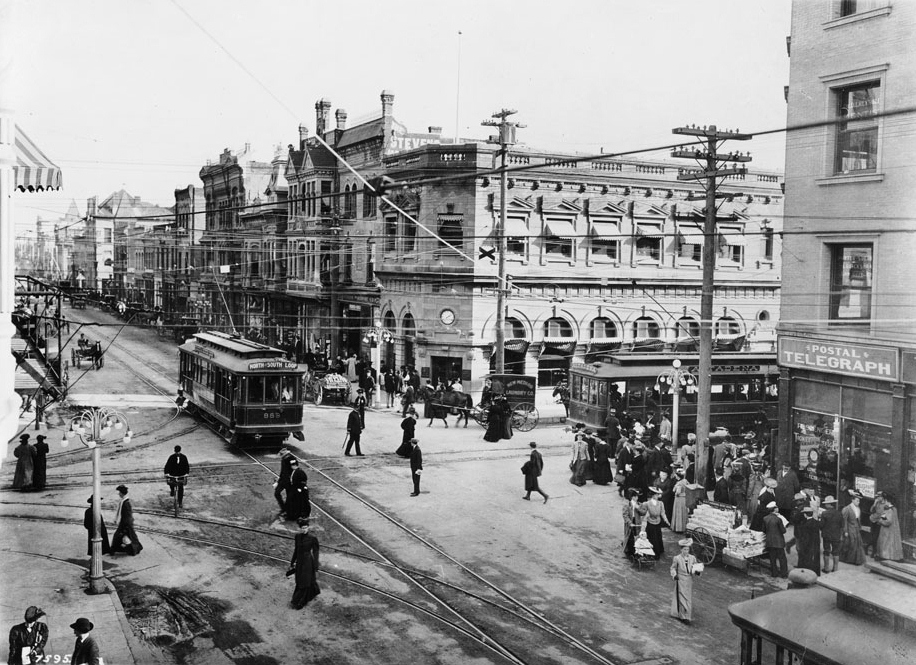
| (1910)^ - View looking south toward the intersection of Fair Oaks Ave and Colorado Street. A trolley with a sign that reads: ALTADENA waits while another trolley with a sign that reads: NORTH SOUTH LOOP passes through the intersection. The sidewalks and streets are full with people, horse-drawn wagons, and a cyclist. To the right is a postal-telegraph office. |
 |
|
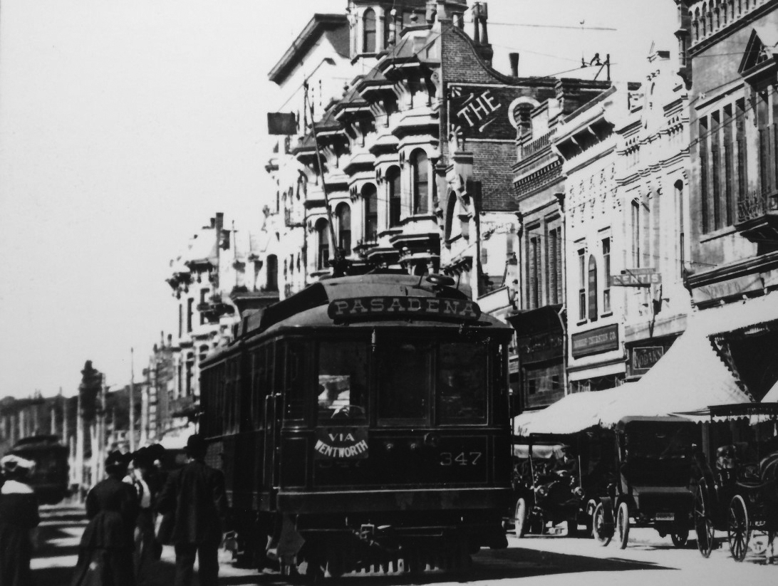
| (ca. 1910)*x* – Close-up view showing passengers waiting to board a streetcar on Colorado Street with early model cars seen parked along the curb. The Carlton Hotel can be seen in the background. |
 |
|
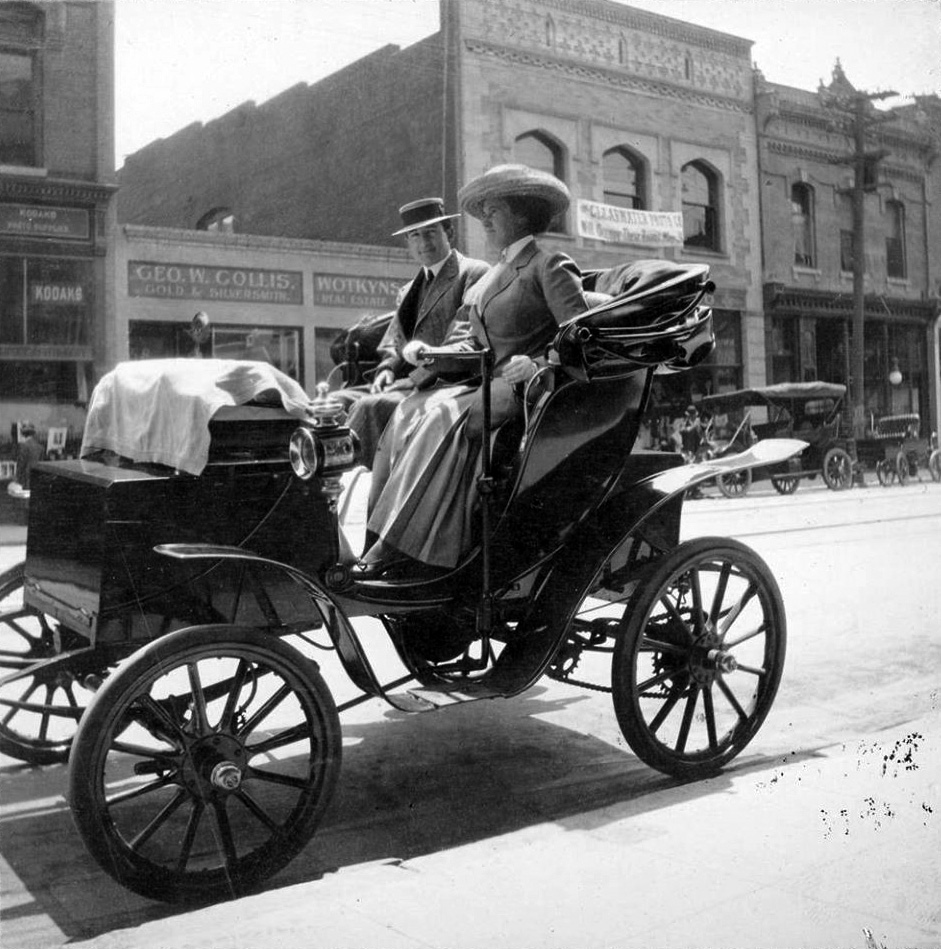
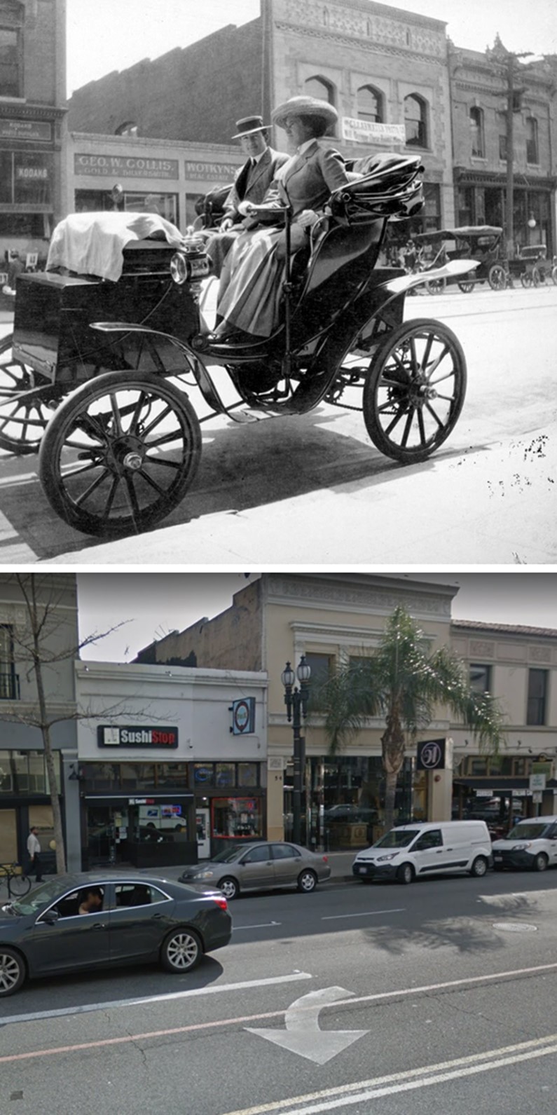
| (ca. 1911)* – A couple are seen driving a 1906 Woods' Queen Victoria electric automobile down Colorado Boulevard. The background is 54-60 E. Colorado Blvd. |
Historical Notes The man in the car is Charles Gibbs Adams, a landscape architect and historian in Pasadena. The woman at the steering tiller is identified only as “Mary”. |
Then and Now
 |
|
| (1911 vs. 2019)*– Looking toward the south side of Colorado Boulevard just west of Raymond Avenue.. |
Historical Notes In the 1920s and following decade, it was decided to widen what was then Colorado Street (today, Boulevard), so the structures were cut back. Also, the Victorian facades were deemed 'old-fashioned', thus, they were replaced mostly with Art Deco and Spanish Colonial motifs. If you compare the stepped roof line on the center you can see just how much of the building was removed when the street was widened. |
 |
|
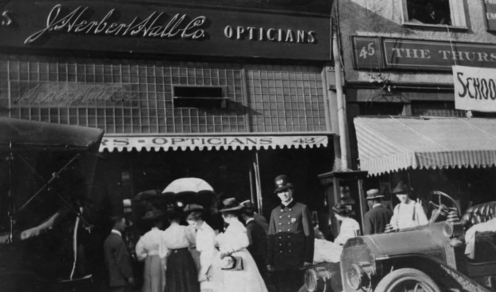
| (1910)** - Small crowd gathers outside J. Herbert Hall Jewelers, located on 43 East Colorado. The officer is guarding a 60 3/4 karat diamond that is placed in the store window. |
Warner's Photoplay Theatre
 |
|
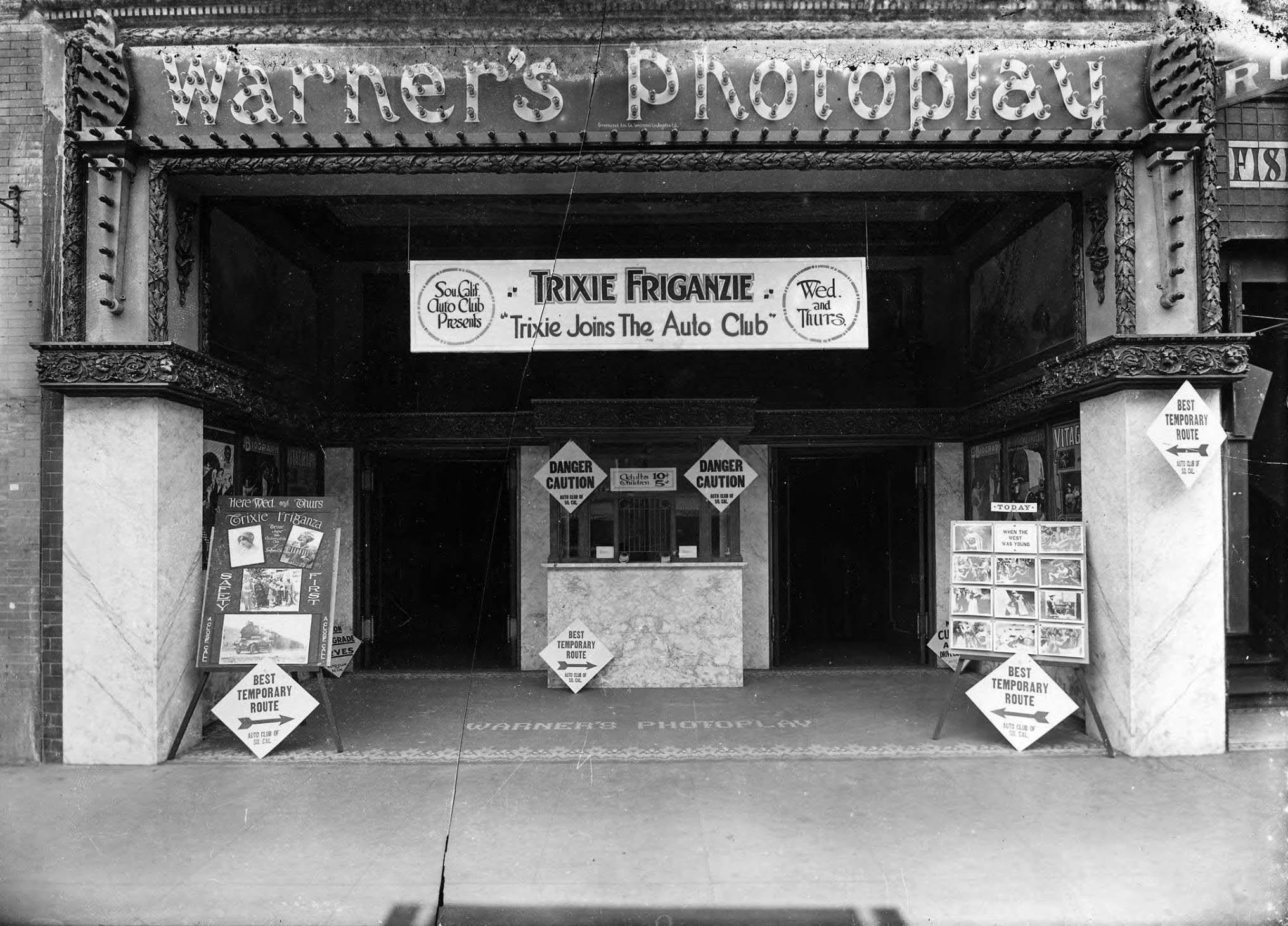
| (1914)*^* – View showing Warner's Photoplay Theater, located at 28 East Colorado Street with special showing of “Trixie Joins the Auto Club”, starring vaudeville star and new film actress Trixie Friganza, sponsored by the Automobile Club of Southern California. |
Historical Notes Opened in August of 1914, Warner’s Photoplay Theater was one of the first motion picture theaters offering air-conditioning. It was a welcome relief from Pasadena's hot August temps. *^* |
* * * * * |
 |
|
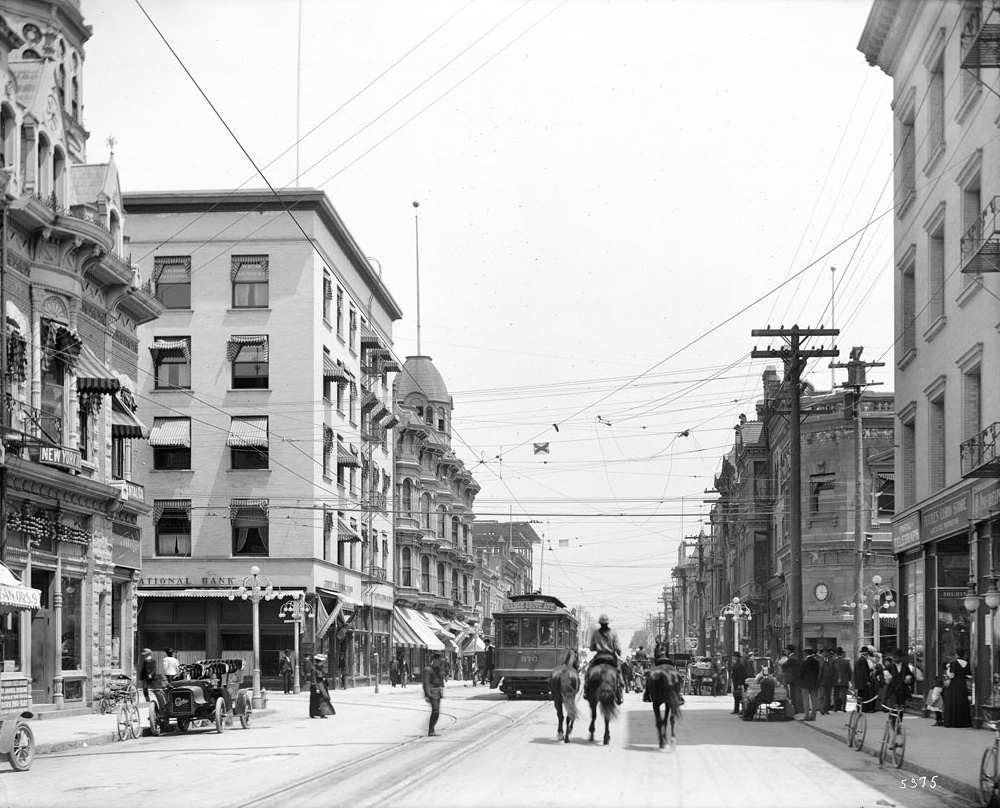
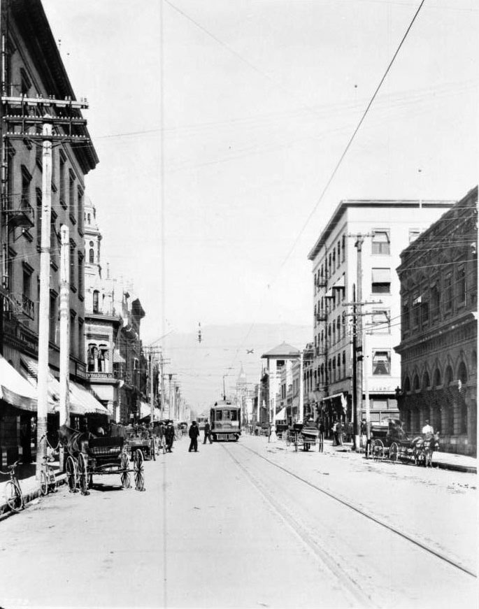
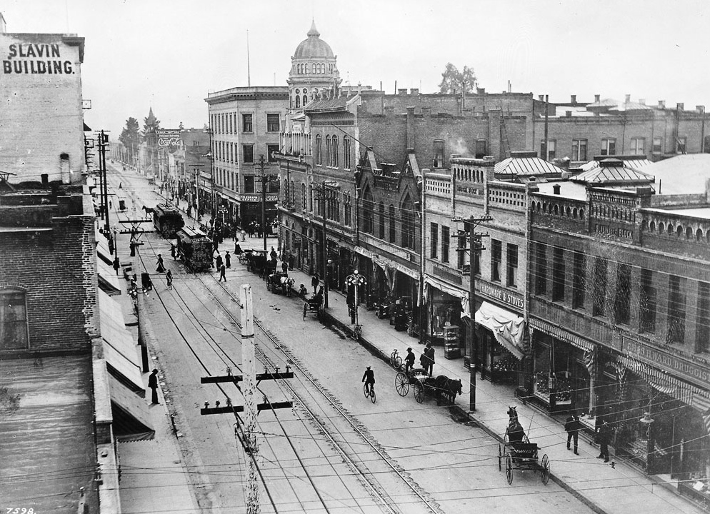
| (ca. 1910)^ – View of Fair Oaks Avenue looking north from Colorado Street. A streetcar featuring a sign that reads "Pasadena" makes its way down the avenue at center, while horse-drawn carriages are parked along with bicycles to either side, at the feet of high rise shop buildings. A carriage in the shape of a large shoe stands to the right, illegible advertising written on its side. Legible signs include: "Philadelphia Shoe Co.", "New York Dental Co.", "Money to Loan", "First National Bank", and "Parker Bros. Dentist". |
 |
|
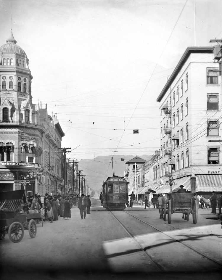
| (ca. 1910)^ - View looking north up Fair Oaks Avenue at Colorado Boulevard (then named Colorado Street). On the northeast corner stands the First National Bank. A trolley and a horse-drawn wagon share the road. The sign on the trolley reads: OSTRICH FARM |
Historical Notes The Cawston Ostrich Farm became a premier tourist attraction for many years. Its proximity to the trolley line that came through from downtown Los Angeles brought many tourists to visit the farm through the earlier part of the 20th century.*^ |
 |
|
| (ca. 1910)++# – View showing houses on Terrace Drive just below Colorado Blvd., Pasadena. |
 |
|
| (ca. 1915)++# - View of the south side of the 400 block of W. Colorado Blvd., Pasadena. The tops of three of houses seen in previous photo can be seen here. Note the B.P.O.E. Lodge 672 built 1911 (still standing) at right. Click HERE for contemporary view. |
Cawston Ostrich Farm
 |
|
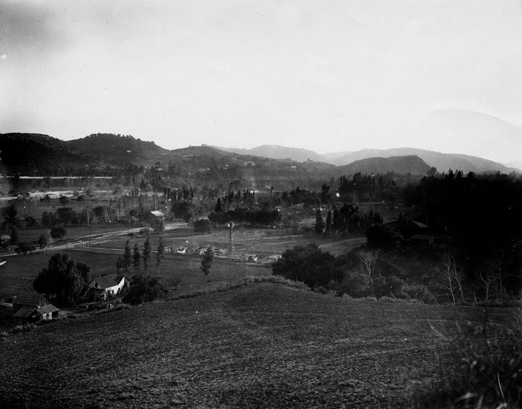
| (1910)* - View of the Cawston Ostrich Farm, South Pasadena, in 1910. |
Historical Notes Cawston Ostrich Farm, located in South Pasadena, was opened in 1886 by Edwin Cawston. It was America's first ostrich farm and was located in the Arroyo Seco Valley just three miles north of downtown Los Angeles and occupied nine acres.*^ |
 |
|
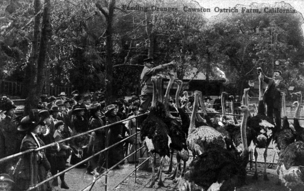
| (ca. 1907)^#^^ – Postcard view showing two men feeding oranges to ostriches at Cawston Farm as spectators watch on. |
Historical Notes In 1885 Edwin Cawston charted a ship to take fifty of some of the best obtainable ostriches in the world from South Africa to Galveston, Texas. From there, the ostriches endured a treacherous train journey to South Pasadena. Out of the original fifty, only eighteen survived. Cawston bounced back from the loss of over half of his stock and the Ostrich Farm eventually boasted over 100 ostriches from the original batch.*^ |
 |
|
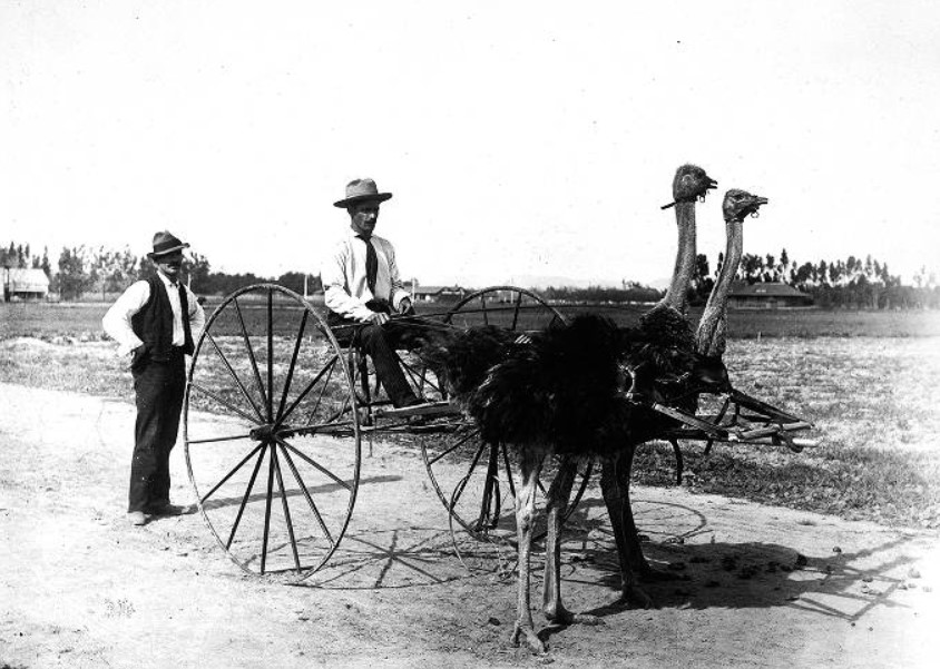
| (1905)#* - Cawston Ostrich Farm, South Pasadena. Two ostriches are hooked up to a buggy with one man seated with a driving whip and one man standing at the rear. |
 |
|
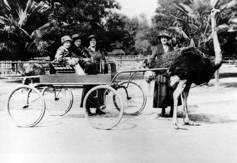
| (1922)* - View of two children sitting in an ostrich drawn wagon while two women stand in the background, all posing for the camera. |
Historical Notes Cawston Ostrich Farm guests were able to ride on the backs of ostriches and to be taken for ostrich drawn carriage rides. They also could buy ostrich feathered hats, boas, capes and fans at the Ostrich Farm store that was connected to the factory. The ostrich farm feather products were shipped and sold throughout the world.*^ |
 |
|
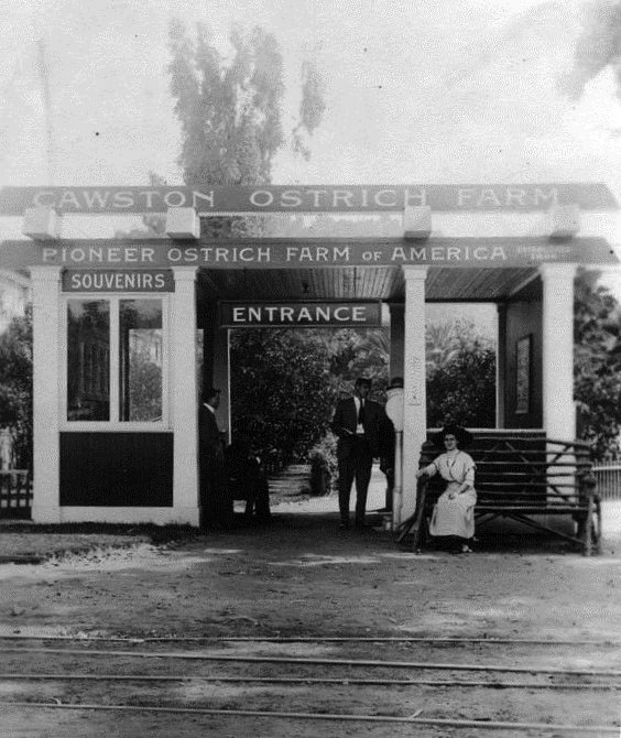
| (1912)* - View of the entrance to Cawston Ostrich Farm on August 4, 1912. |
 |
|
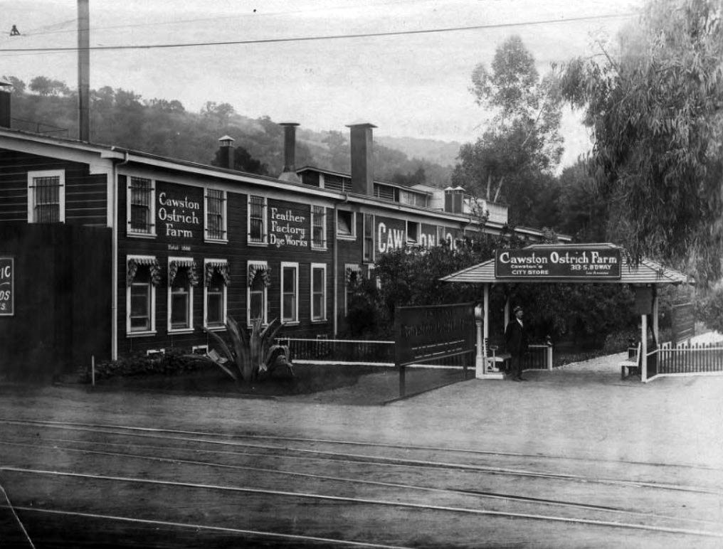
| (ca. 1920)^#^^ – View of the entrance to Cawston Ostrich Farm. Edwin Cawston, who initially established an ostrich breeding farm in Southern California in 1886, opened his famous farm in South Pasadena in 1896. A sign above the entry way references the farm's Los Angeles city store on South Broadway. |
Historical Notes Most of the original brick structure of the factory and store remains today and is South Pasadena Cultural Landmark #18.*^ |
 |
|
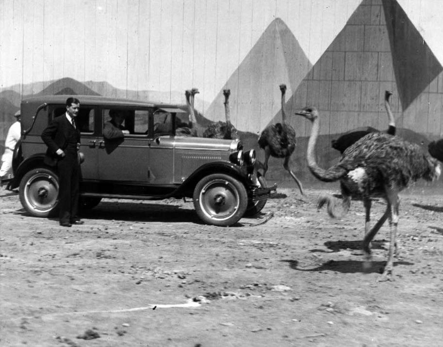
| (ca. 1930s)^#^^ - Ostriches roam the Cawston Ostrich Farm grounds and examine an automobile while two men look on. The pyramids in the enclosure provide an exotic backdrop, reflecting the ostriches' native Africa. |
 |
|
| (ca. 1910)^ - Looking south on Fair Oaks Avenue from just north of Colorado Boulevard, circa 1910. |
City Hall
 |
|
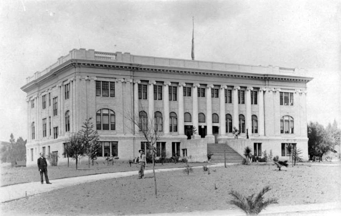
| (ca. 1911)* - Exterior view of City Hall in Pasadena located on the northeast corner of Fair Oaks and Union. Note the architectural designs on the building. Horse-drawn buggy's are parked along the sidewalks. |
Historical Notes In 1911 City Hall occupied a building at Union and Fair Oaks. Since then City Hall moved several times, and the building was lost, only to be replaced in 2003 by a quasi replica now known as the Container Store.*^ |
 |
|
| (1917)^^*# - HISTORIC HEADLINE FOR MARCH 26, 1917 - 'Display of flags now patriotic duty says city official: Situation is now declared to constitute prescribed "Special Occasion" (Pasadena Star News) |
* * * * * |
 |
|
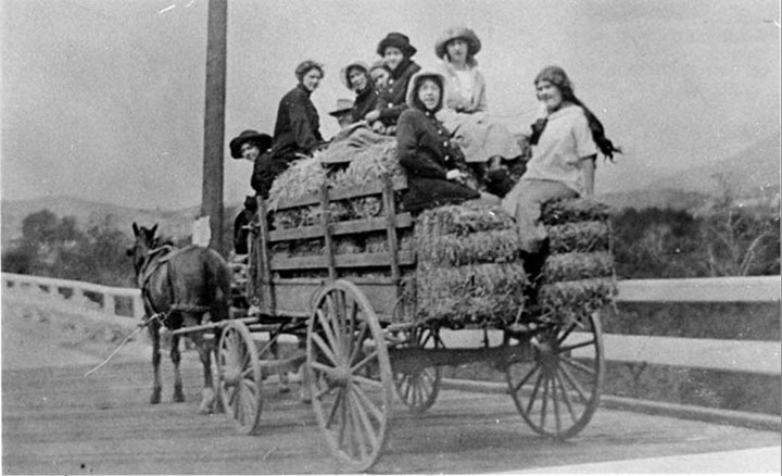
| (1911)*^# - Arriving in Style? A wagon trip from Pasadena to Glendale in 1911. The description on the reverse of this photo reads: "the girls had gone to a house party and it rained all the way home." *^^^ |
Second Raymond Hotel
 |
|
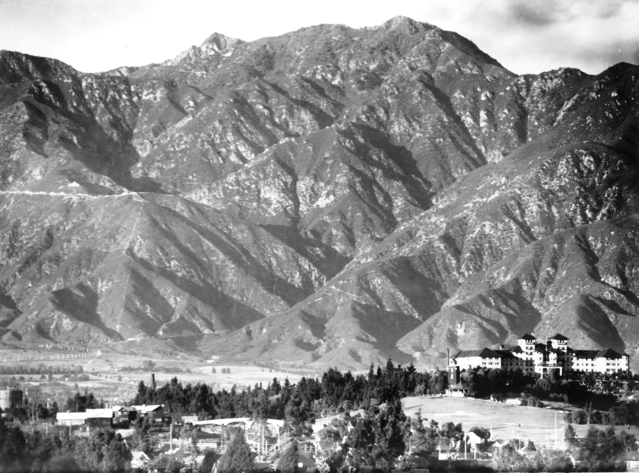
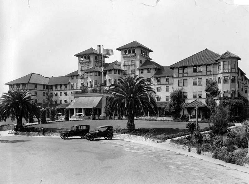
| (1908)^ – View looking north from the Monterey Hills showing the majestic San Gabriel Mountains with the Raymond Hotel seen at lower right. |
Historical Notes The Original Raymond Hotel burned to the ground in 1895. The second Raymond Hotel opened on December 19, 1901 and was met with immediate success especially from those who had lost their winter residence for 6 years. The registry was filled with names of moguls from the East: Pullman, Schwab, Harriman, Swift, Armour, Rockefeller, Morgan, Carnegie, and of course R. T. Crane who spent his remaining winters at the Raymond.*^ |
 |
|
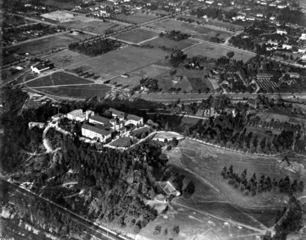
| (ca. 1918)^ - Aerial view showing the Hotel Raymond and surrounding area. At the base of the hill is a gazebo and a tennis court. To the right of the hotel is a large open field; there are other open fields above the hotel as well. The upper right corner of the image shows the edge of a residential area. |
Historical Notes Located atop Bacon Hill, renamed Raymond Hill, which lies between Pasadena and South Pasadena, the first Raymond Hotel burned down in 1895 and was replaced by a second (seen above) in 1903.* Click HERE to see more on the 1st Hotel Raymond. |
 |
|
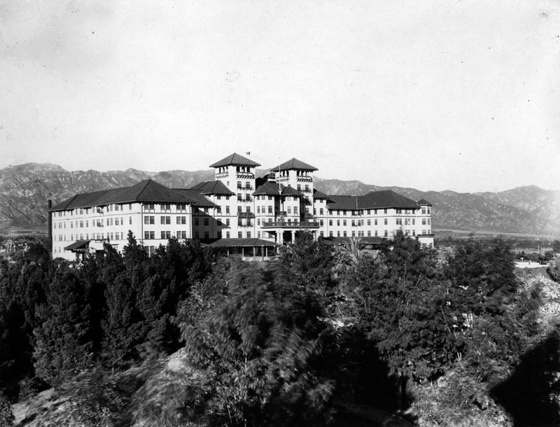
| (ca. 1910s)* - View of the second Raymond Hotel looking across the grounds at the western facade, the main entrance to the hotel. In the background are the San Gabriel Mountains. |
 |
|
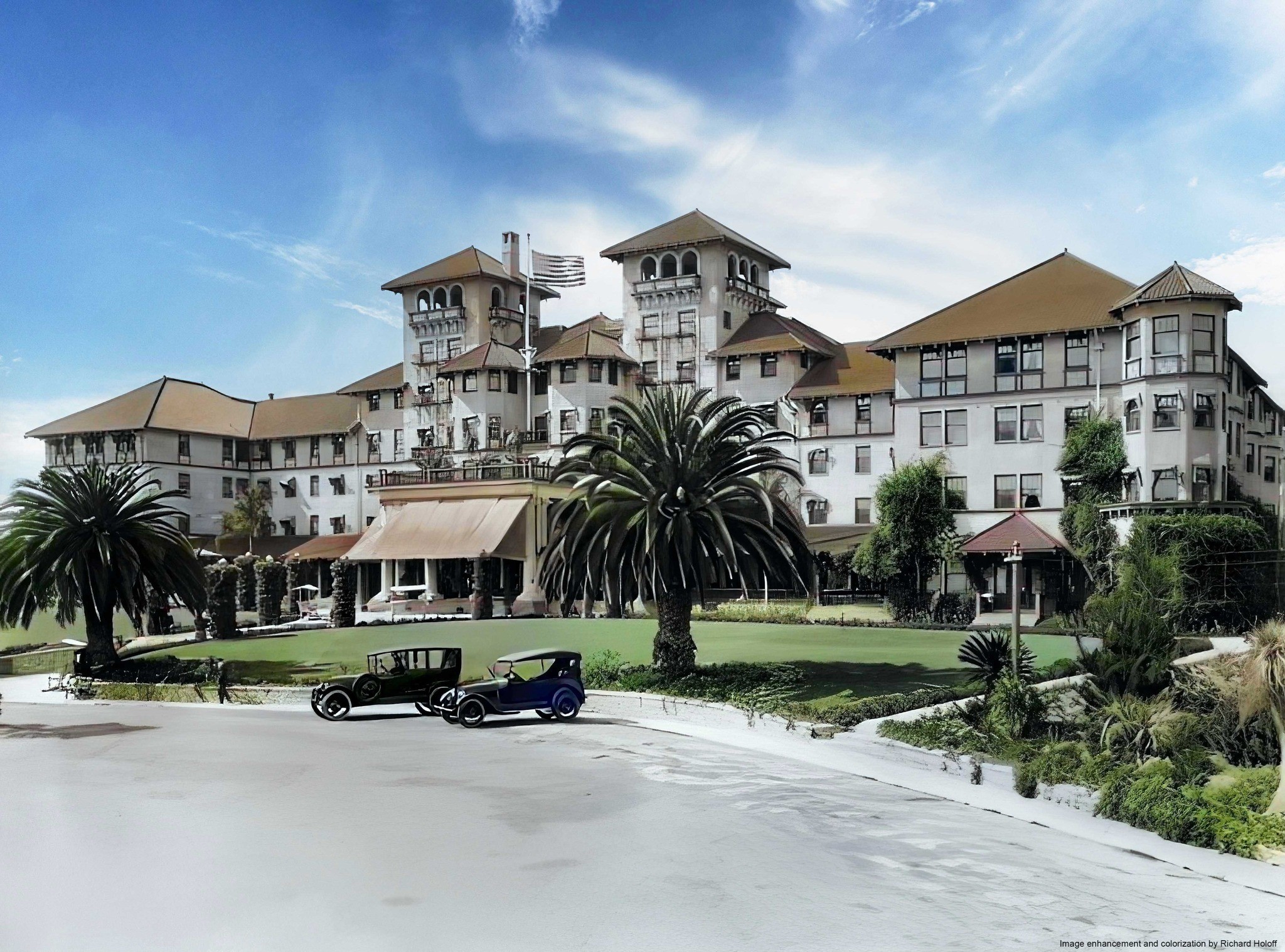
| (ca. 1910s)^## - View of two cars parked in front of the second Raymond Hotel. The architect was T. W. Parkes. |
Historical Notes The Raymond was a landing-place for well-heeled visitors in the area until the Huntington Hotel, another luxury resort also located in Pasadena began receiving visitors in 1914. |
 |
|
| (ca. 1910s)^## - View of two cars parked in front of the second Raymond Hotel. The architect was T. W. Parkes. Image enhancement and colorization by Richard Holoff. |
 |
|
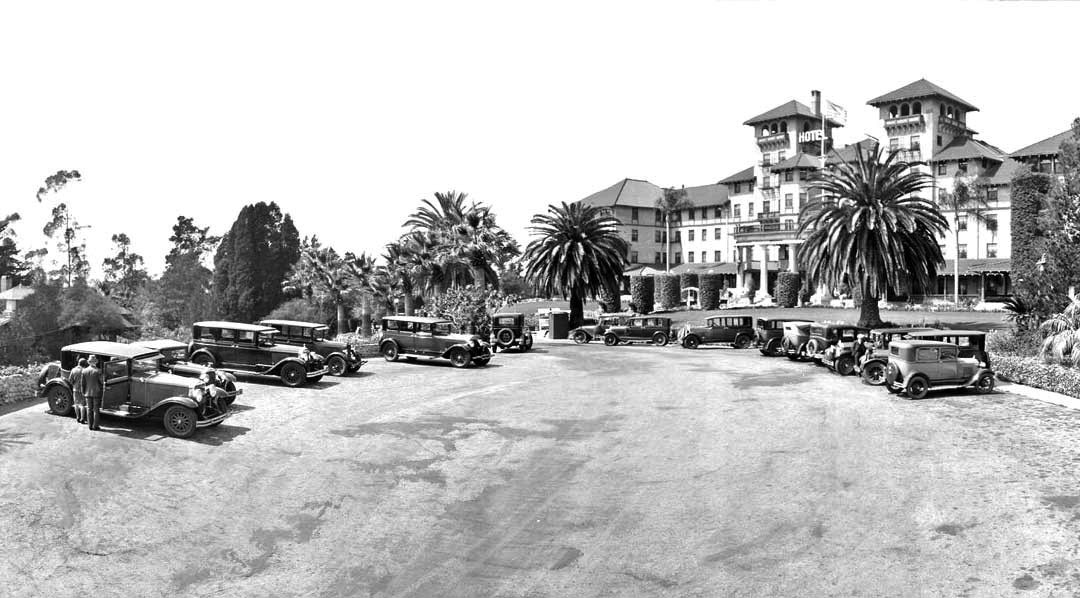
| (ca. 1928)#* – View showing a lot full of cars in front of the Raymond Hotel. |
 |
|
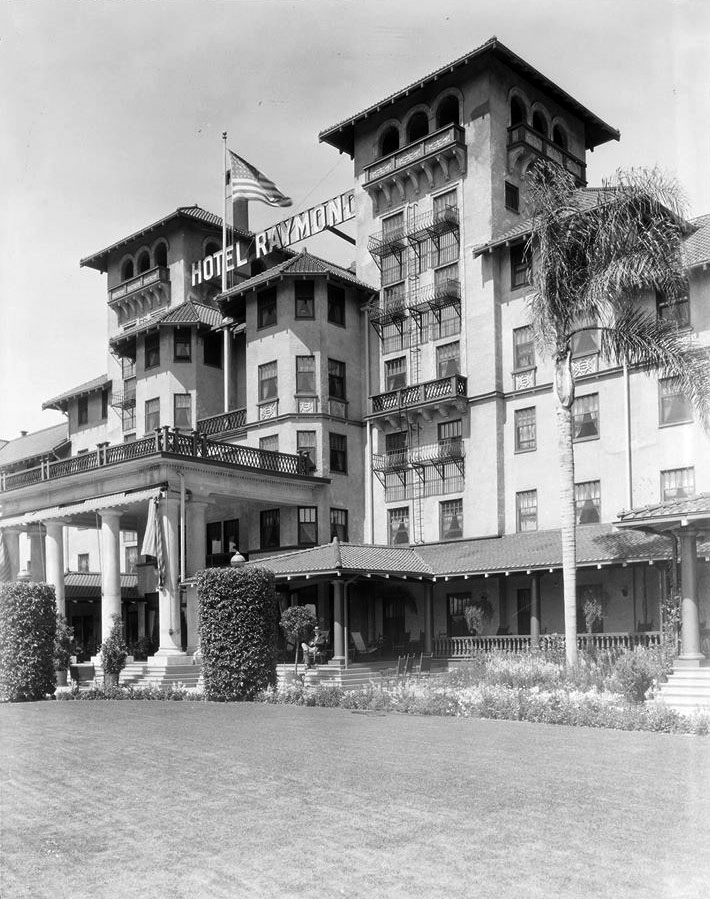
| (1929)#* – View showing the Raymond Hotel, 1200 South Fair Oaks, South Pasadena. |
Historical Notes During the Great Depression, 1931, the Raymond Hotel starting seeing a major decline in the number of guests. Mortgage payments became due and could not be met. The bank foreclosed on the hotel and Walter Raymond lost the property. The owner of the Maryland Hotel, Daniel M. Linnard, sought to manage the property for a while, but in 1934, the year of Walter Raymond’s death, the hotel was torn down for commercial development.*^ |
Dirigible Flights at the Raymond Hotel
 |
|
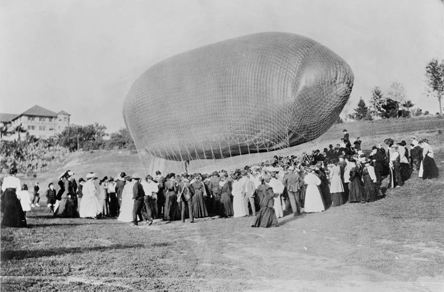
| (1905)* - View of Roy Knabenshue landing his dirigible on the Raymond Hotel grounds, surrounded by a large crowd of people. |
Historical Notes CA. Roy Knabenshue made outstanding contributions to aviation as an aeronaut making balloon flights. He was among the first to pilot a steerable balloon, one of the pilots of the first successful American dirigible, a builder and exhibitor of dirigibles of his own design, manager of the Wright Brothers’ Exhibition Team, and a leading builder of observation balloons during World War I.* |
 |
|
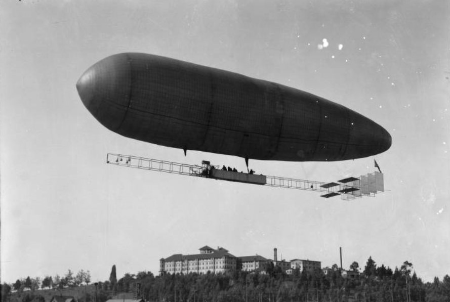
| (1913)* - A view showing Roy Knabenshue flying his new multi-passenger dirigible with the Raymond Hotel in the background. There are people in the undercarriage which runs the length of the airship. |
Historical Notes Roy Knabenshue was the first to make a dirigible balloon flight over the skyscrapers of New York back in 1905, one year after his original lighter-than- air powered flight at the St. Louis Exposition. After several years of barnstorming and a stretch as general manager for the Wright Brothers, he went west and built a 13-passenger airship in Pasadena for passenger flights.* |
 |
|
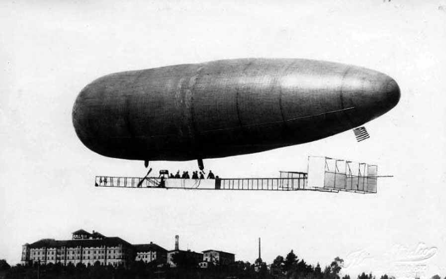
| (1913)* - Roy Knabenshue flying his 13-passenger dirigible over the Raymond Hotel. He offered aerial tours of the City of Pasadena. |
Click HERE to see more in Aviation in Early L.A. |
Oneonta Park Junction (South Pasadena)
 |
|
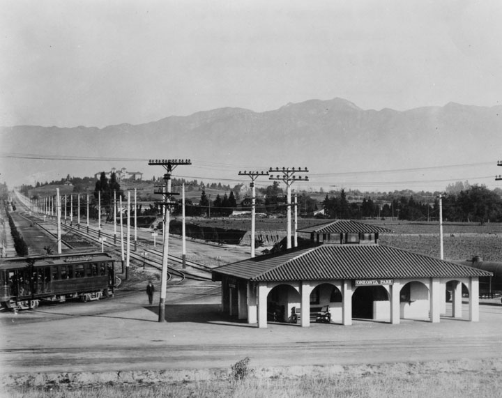
| (ca. 1910)^ - View showing Oneonta Park and Pasadena on a clear day as seen from the hill to the south, Huntington Drive & Fair Oaks Avenue, South Pasadena. Two sets of streetcar tracks merge behind the station (center) to form parallel tracks that lead into the distance. The Raymond Hotel can be seen on a hill in the background with the San Gabriel Mountains in the distance. |
Historical Notes The Oneonta Park Tract came into being in 1902 when Henry Huntington changed the name of the existing Monrovia Junction to Oneonta, the name of his hometown in New York. He described Oneonta Park as a model suburb with rail transportation to downtown Los Angeles as more than 750 Red Cars passed in a single day. The name Oneonta was widely used in South Pasadena – Oneonta Military Academy, Oneonta School, Oneonta Congregational Church, Oneonta Club, and many others. The Oneonta Tract encompassed several hundred acres in the area of Huntington Drive and Fremont Avenue, east to Fletcher Avenue and south to the Alhambra city limits. ^ |
 |
|
| (ca. 1915)* - Closer view showing the Spanish Revival style station; inside cupola is a switching station for the four-tracking system for the Pasadena Short Line of the Pacific Electric Railway Company. The Raymond Hotel is seen on a knoll at center-left with San Gabriel Mountains beyond. |
Historical Notes The Oneonta Park Station was constructed in 1906 and had a small counter where tickets, daily newspapers and soft drinks could be purchased before boarding the Red Cars. A tower located within the station housed an interlocking system which controlled all the switches at the Junction, including Southern Pacific Railway crossing at Huntington Drive and Marengo Avenue. From the tower, the controller had a view in all directions. The Oneonta Park Station was demolished when operations were discontinued in late 1951. ^ Click HERE to see more early views of Oneonta Park Junction (1937 +). |
* * * * * |
Raymond and Colorado
 |
|
| (ca. 1918)^## – View looking north on Raymond Avenue at Colorado Boulevard showing a policeman standing on a box at the middle of the intersection. Click HERE to see contemporary view. |
Then and Now
 |
|
| (1918 vs. 2022)* – View looking north on Raymond Avenue at Colorado Boulevard. |
 |
|
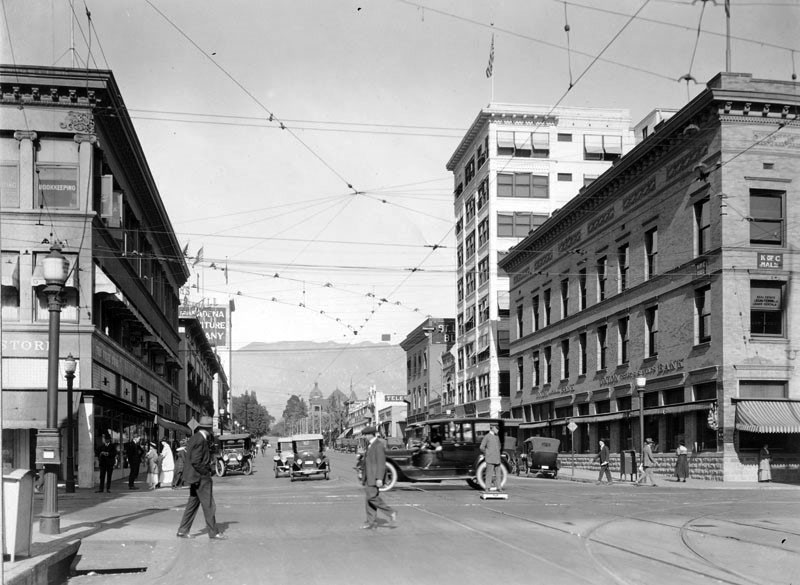
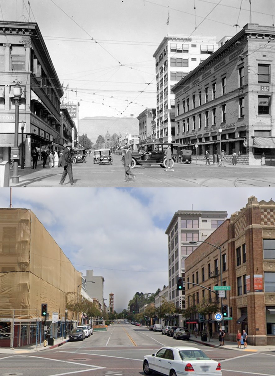
| (ca. 1918)^## – View looking north on Raymond Avenue just north of Colorado Boulevard. The Pasadena Furniture Company building can be seen in the distance. Click HERE to see contemporary view. |
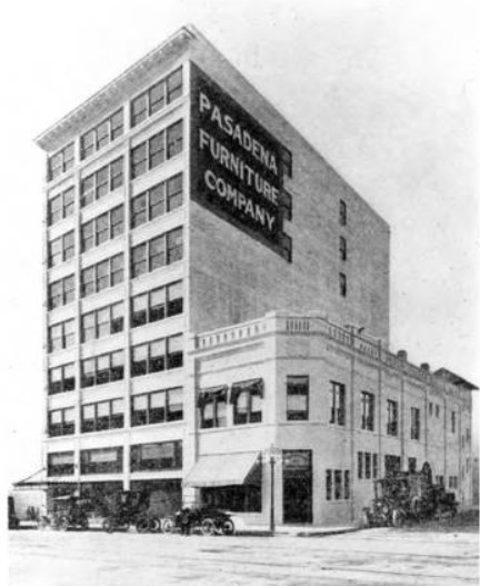 |
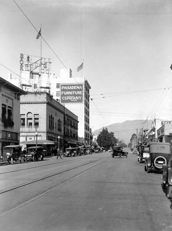
(1915)**- View of the Pasadena Furniture Company. Picture taken from 1915 Tournament of Roses Program. According to the 1916 Pasadena City Directory, the Pasadena Furniture Company was at 83-91 Raymond Avenue. Click HERE to see contemporary view.
|
.jpg) |
|
| (ca. 1920)++# – View looking east on Colorado Boulevard from Raymond Avenue showing a uniformed officer directing traffic from the middle of the intersection. |
 |
|
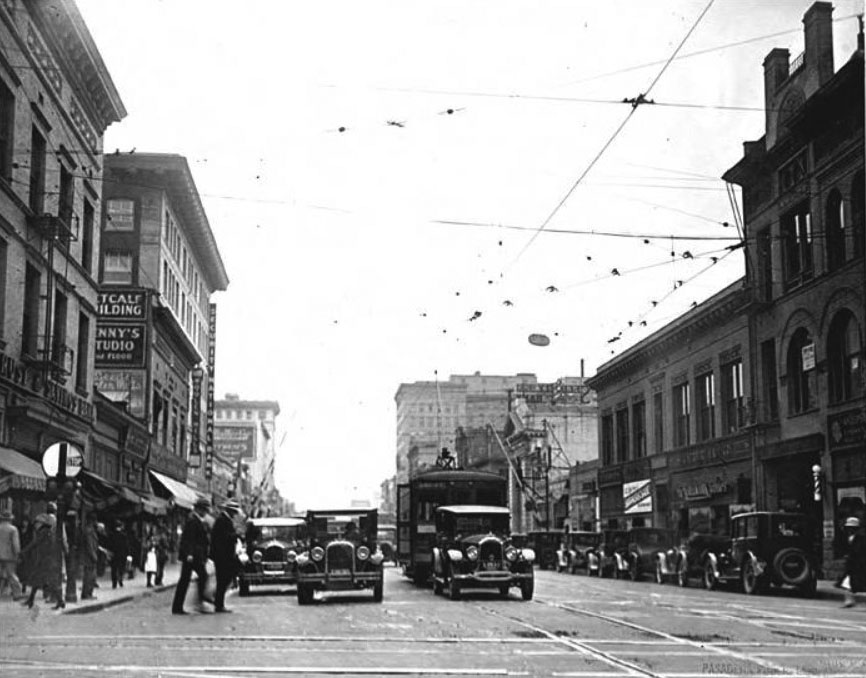
| (1926)*^* – View looking east on Colorado from Raymond showing several people crossing the street with streetcar and autos waiting at the intersection. Note the overhead streetcar wire above the intersection. |
 |
|
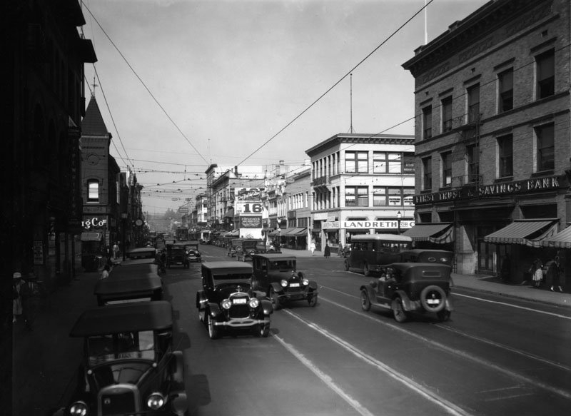
| (1920s)* - Cars on Colorado Boulevard with the First Trust & Savings Bank seen on the right, at Raymond Avenue. |
* * * * * |
Mt. Wilson Observatory
 |
|
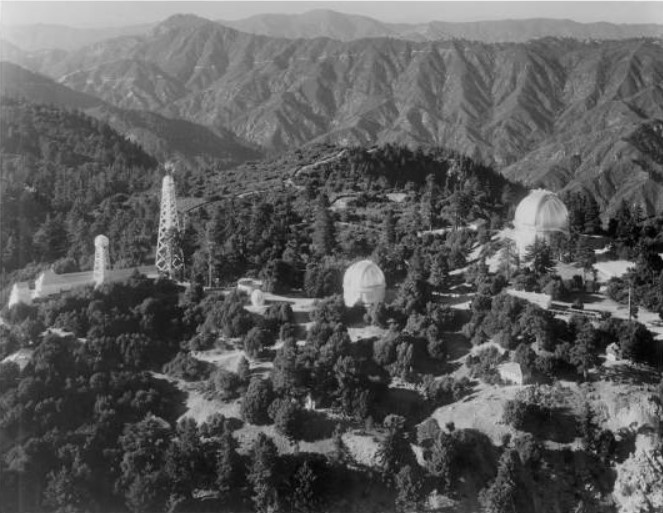
| (1932)#* - Aerial view of Mount Wilson Observatory from the southeast located in the San Gabriel Mountains near Pasadena. |
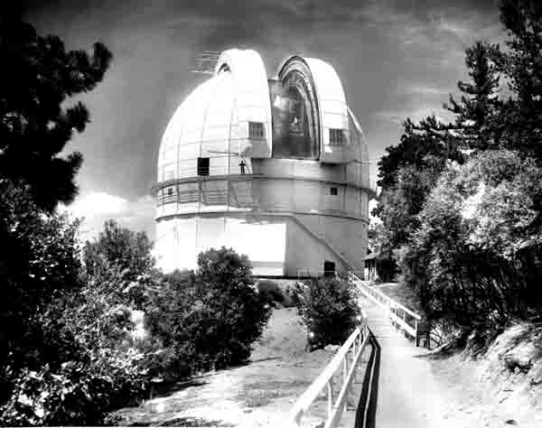
Historical Notes The Mount Wilson Observatory is located on Mount Wilson, a 5,715-foot peak in the San Gabriel Mountains near Pasadena. The observatory contains two historically important telescopes: the 60-inch Hale telescope built in 1908 and the 100-inch Hooker telescope, which was the largest telescope in the world from its completion in 1917 until the 200-inch Hale telescope at Palomar Observatory was built in 1948. |
 |
|
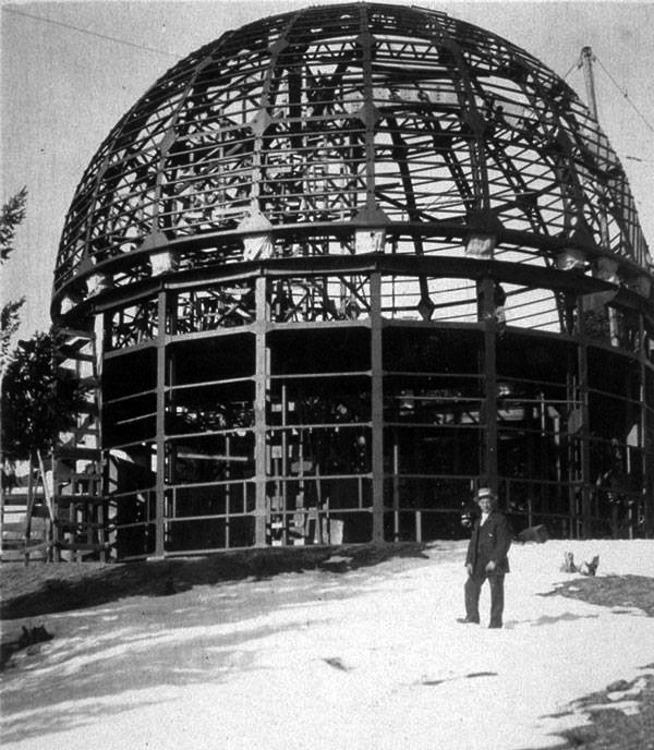
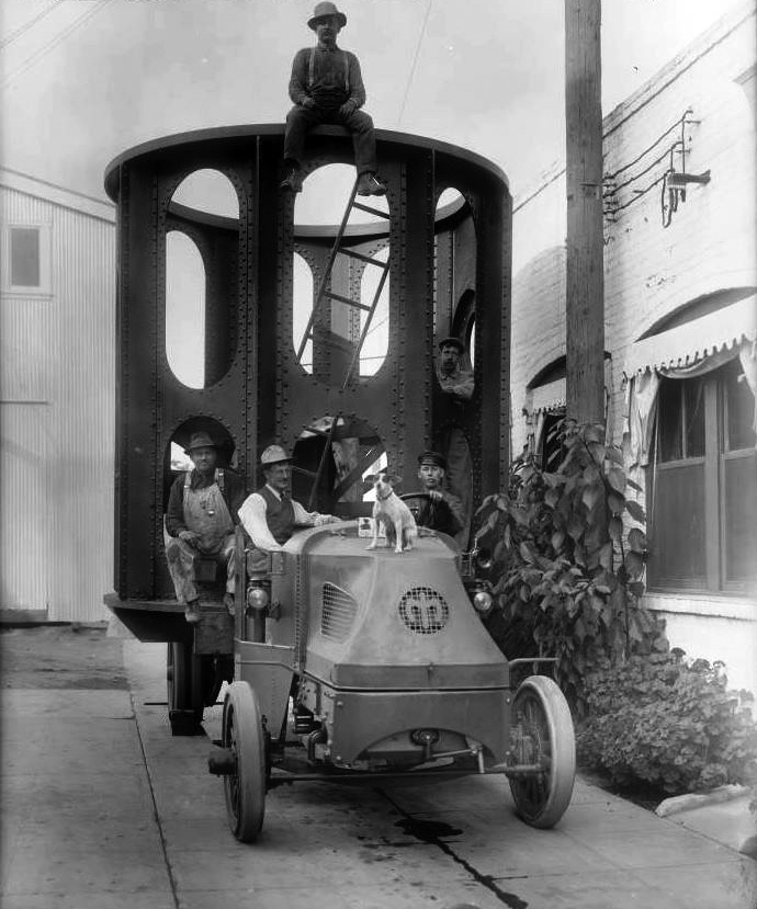
| (ca. 1907)* – View showing a man posing in front of the 60" Telescope Dome under construction. |
Historical Notes The 60-inch Hale telescope was the largest telescope in the world when it was completed in 1908. |
 |
|
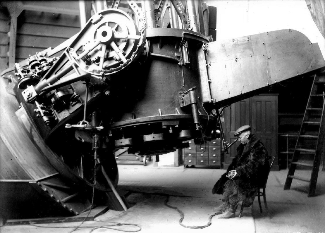
| (1912)* - Astronomer Wendell Hoge at eyepiece of 60-inch Hale Telescope at Mt. Wilson. Note the fur coat and leggings. |
Historical Notes One of the things that astronomers had to learn in those days was how to stay warm on cold nights [this shot was taken in December] working with a telescope. The instrument had to be the same temperature as the outside air, and the astronomer couldn't move very much. |
 |
|
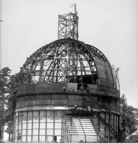
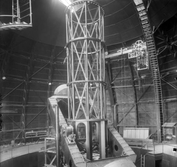
| (1915)#* - View of the 100 inch telescope dome under construction at the Mount Wilson Solar Observatory. Workman are seen posing on the structure. |
Historical Notes Mount Wilson Solar Observatory was founded in 1904 by George Ellery Hale under the auspices of the Carnegie Institution of Washington (the word "Solar" was dropped from the name in 1919 soon after the completion of the 100-inch telescope). In that year, Hale brought the Snow Solar Telescope from Yerkes Observatory in southern Wisconsin to the sunnier and steadier skies of Mount Wilson to continue his studies of the Sun. With a small cadre of Yerkes scientists and engineers accompanying him, Hale started what would become the world’s foremost astronomical research facility. |
 |
|
| (1916)#* - View of the dome for the 100-inch Hooker Telescope shortly after its completion. |
 |
|
| (1916)++# - View showing the lower housing of the 100" Hooker Telescope loaded and ready for transportation to Mt. Wilson. The location is the Mt. Wilson Observatory Pasadena Offices, 813 Santa Barbara St., Pasadena; the Observatory still maintains its offices at this address. The view is to the north, Santa Barbara is behind the photographer, Lake Ave. is about 100' to the right. |
 |
|
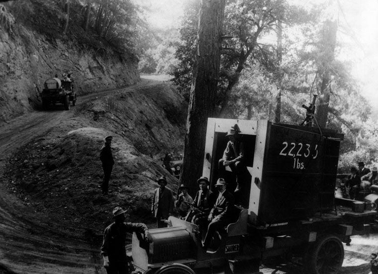
| (1917)* - View showing the 100-inch Hooker Telescope glass being hauled up the one-way dirt toll road from Altadena to Mt. Wilson by truck on the Mt. Wilson Roadway. |
Historical Notes In 1889, the Harvard Telescope was transported up the San Gabriel Mountains and installed at the top of Mt. Wilson. The problems associated with transporting this instrument up the old Wilson trail and the belief that larger telescopes would follow, created an interest in building the Mt. Wilson roadway. As new, larger telescopes were designed for the Mt. Wilson Observatory, an automobile roadway became necessary to accommodate the trucks hauling parts up the mountain. In 1907 the trail was widened to ten feet with most of the work being done by hand with the use of Japanese laborers and mule-drawn scrapers. The road was widened to a full 12-foot roadway in 1917 to facilitate the transportation of parts for the 100-inch Hooker Telescope. |
 |
|
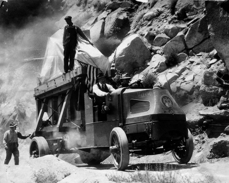
| (1917)* - The 100-inch telescope being hauled up the one-way dirt toll road from Altadena to Mt. Wilson by truck. It was boxed in and draped with an American flag. |
 |
|
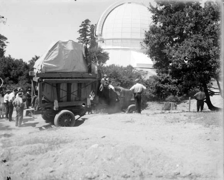
| (1917)#* - Arrival of the 100-inch telescope mirror at Mount Wilson Observatory. The mirror is covered with a white tarpaulin and is loaded in the back of a truck. The observatory dome is seen between trees, to the right of the truck. |
 |
|
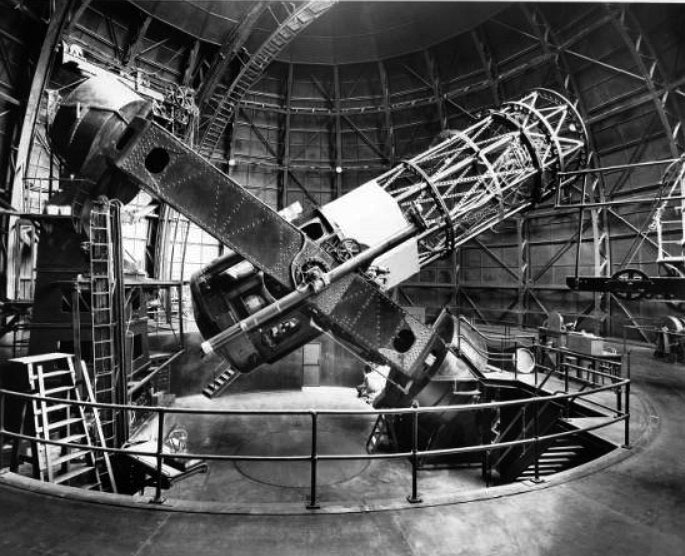
| (1917)#* - View of the Hooker 100-inch telescope tube and mount, nearly complete, Mount Wilson Observatory. |
Historical Notes The first optical interferometer ever used for astronomical research was used on the 100-inch telescope to measure the sizes of distant stars for the first time in 1919. |
 |
|
| (1940)#* - The Hooker 100-inch reflecting telescope, side view with tube 40 degrees from horizontal. Edwin Hubble's chair, on an elevating platform, is visible at left. |
Historical Notes Edwin Hubble used the 100-inch telescope to determine the distances and velocities of neighboring galaxies, demonstrating that they are separate "island universes" and not small nebulae contained within the Milky Way, as many astronomers had previously thought. |
 |
|
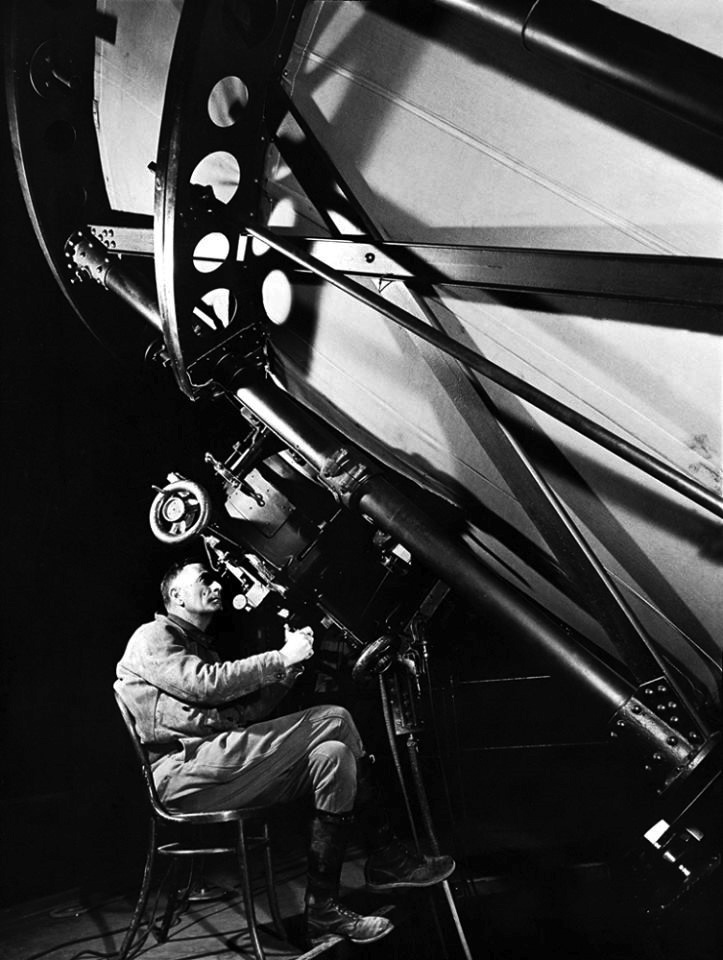
| (1937)* - Astronomer Edwin Powell Hubble stargazes through the Hooker telescope at California's Mount Wilson Observatory. |
Historical Notes Edwin Powell Hubble (1889-1953) played a crucial role in establishing the field of extragalactic astronomy and is generally regarded as one of the most important observational cosmologists of the 20th century. Hubble is known for showing that the recessional velocity of a galaxy increases with its distance from the earth, implying the universe is expanding, known as "Hubble's law" although this relation had been discovered previously by Georges Lemaître, who published his work in a less visible journal. Edwin Hubble is also known for providing substantial evidence that many objects then classified as "nebulae" were actually galaxies beyond the Milky Way. |
 |
|
| (n.d.)#* - View of Mount Wilson's 100-inch Hooker Telescope dome in the early days. |
Historical Notes The Hooker 100-inch telescope is named after John D. Hooker, who provided the funds for the giant mirror. It was the largest telescope in the world from 1917 to 1948 when the 200-inch telescope was built on Palomar Mountain 90 miles to the southeast. |
 |
|
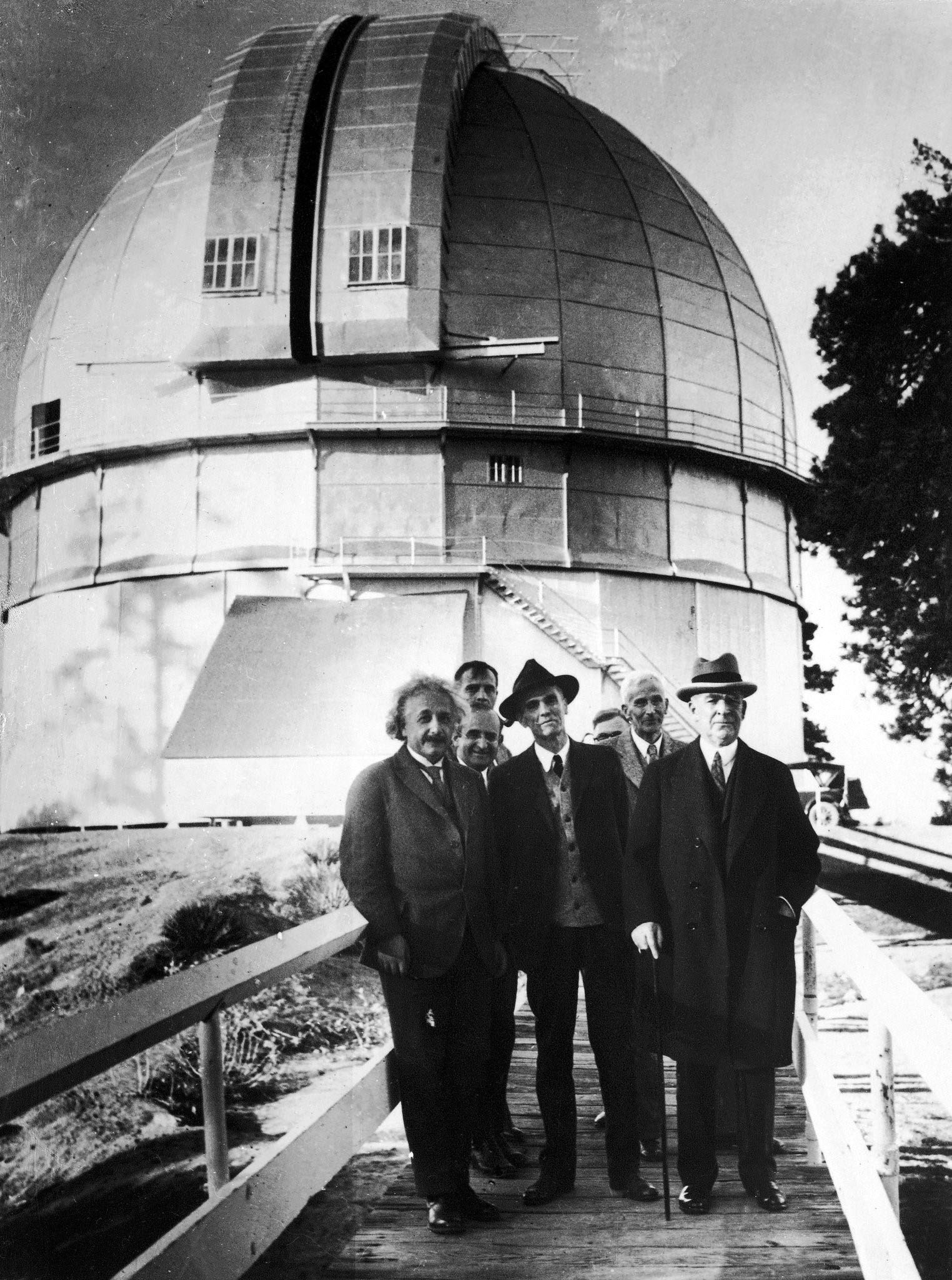
| (1931)* - Albert Einstein, left, and Edwin Hubble, second from left, pose for the camera on the bridge leading to the Mount Wilson 100-inch Hooker Telescope dome. |
 |
|
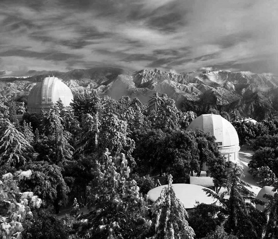
| (n.d.)* - Contemporary winter view of Mt. Wilson looking east; dome of 100" Hooker Telescope is at left, 60" at right; taken from the 150' Solar Telescope. |
 |
|
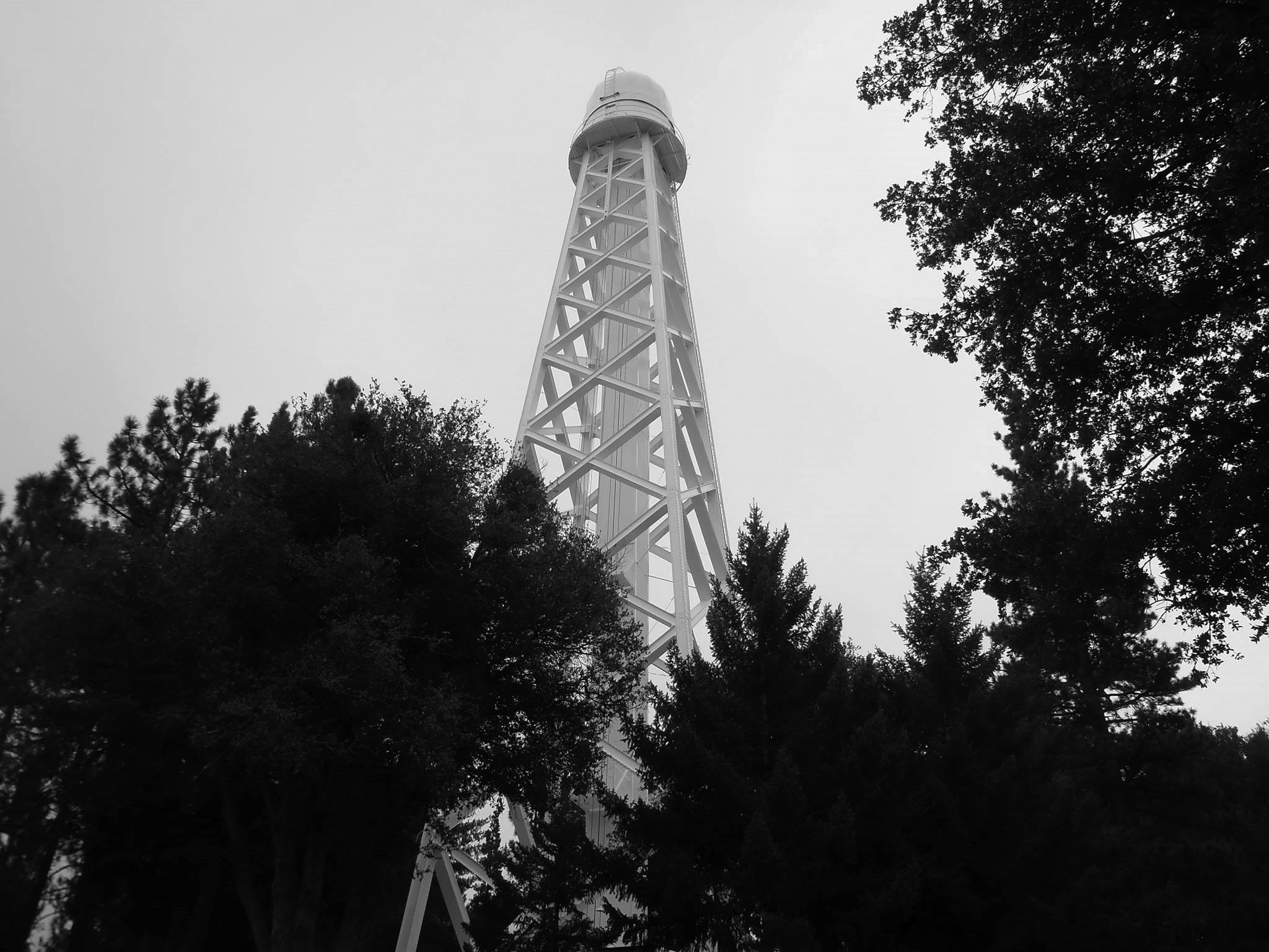
| (2015)* – View showing the 150-foot Solar Telescope at Mt. Wilson. Photo by Roger Klemm |
Historical Notes The horizontal Snow solar observatory was built on Mount Wilson in 1904. It was soon found that heat radiation was disrupting observations. Almost as soon as the Snow Observatory opened, plans were started for a 60-foot-tall tower that opened in 1908 followed by a 150-foot tower in 1912. The 60-foot tower is currently used to study helioseismology, while the 150-foot tower is active in UCLA's Solar Cycle Program.*^ |
 |
|
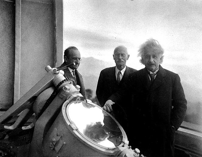
| (1931)* - Albert Einstein at the top of the 150-foot Solar Telescope, Mount Wilson, with solar physicist Charles St. John (middle) and mathematician Walther Mayer (left). |
 |
|
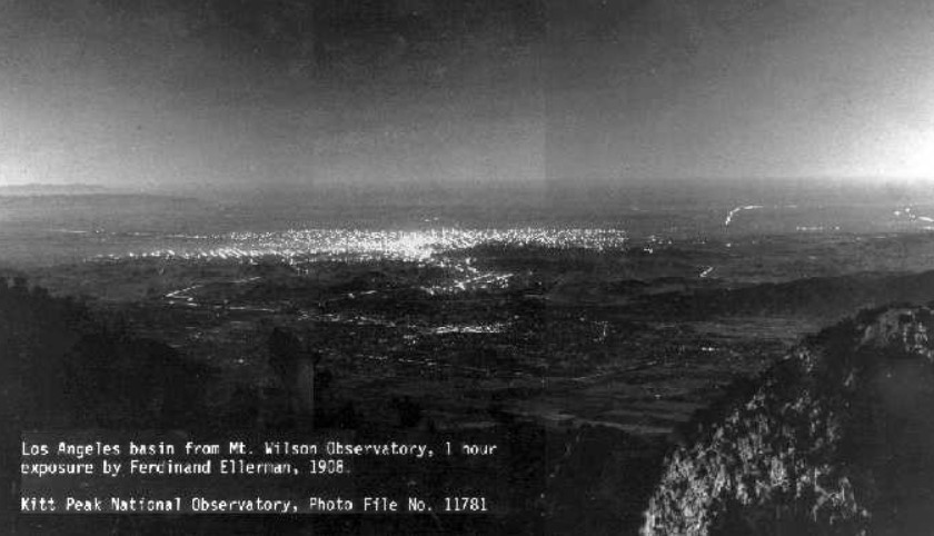
| (1908)^^^^* - Panoramic view showing Pasadena and Los Angeles as seen from Mount Wilson (elevation of 5000’) showing some of the main streets and roads which exists today and an extensive view of outdoor electric lights. The brightest lights are in downtown Los Angeles, some 20 miles distant. |
 |
|
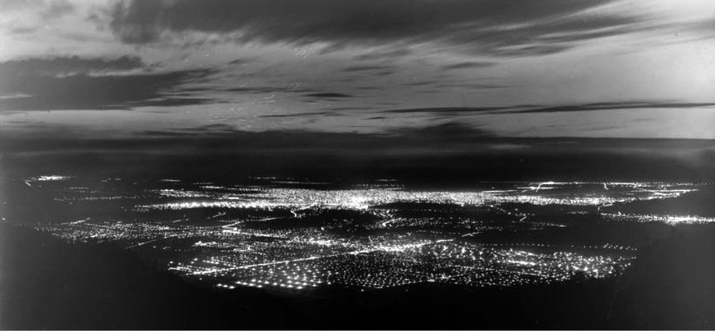
| (1918)#* - View from Mt. Wilson from approximately the same location as the 1908 photo. The intersection of Lake Avenue and Colorado Boulevard in the City of Pasadena in the foreground, with the Los Angeles Civic Center area in the middle of the photograph. |
Historical Notes Over the years, the increasing light pollution due to the growth of greater Los Angeles has limited the ability of the observatory to engage in deep space astronomy, but it remains a productive center, with many new and old instruments in use for astronomical research. |
 |
|
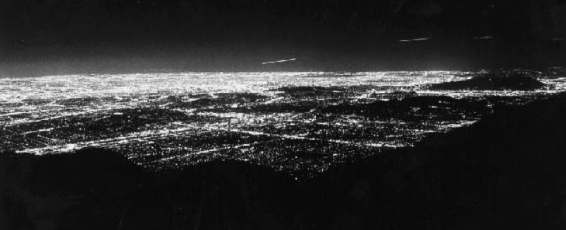
| (1988)^^^^* - View from Mt. Wilson from approximately the same location as previous photos. This was a 15-second exposure showing the dramatic growth of outdoor lighting throughout the greater Los Angeles basin. Click HERE to see more in Early Streetlights. |
Historical Notes In 1928, George Ellery Hale secured a grant of six million dollars from the International Education Board, a funding agency endowed by the Rockefeller Foundation, for "the construction of an observatory, including a 200-inch reflecting telescope... and all other expenses incurred in making the observatory ready for use." The 5,600-ft tall Palomar Mountain, located 100 miles south of Pasadena, was selected as the site of the new observatory. Construction of the observatory facilities and dome started in 1936, but because of interruptions caused by World War II, the telescope was not completed until 1948 when it was dedicated. Due to slight distortions of images, corrections were made to the telescope throughout 1949. It became available for research in 1950. Unlike the Mt. Wilson observatories, which are operated by the Carnegie Institution, the 200-inch is administered by the California Institute of Technology (Caltech). |
Mt. Wilson Toll Road
 |
|
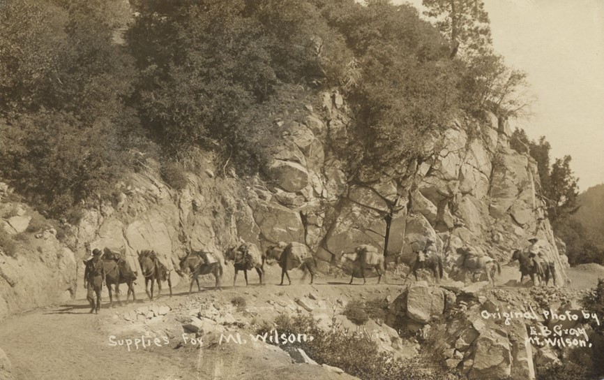
| (1904)* - A pack train carrying supplies on the road to the observatory at the summit of Mount Wilson. Photo by E.B. Gray |
Historical Notes The installation of the Harvard telescope in 1889, which brought its own problems of transporting the instrument up the old Wilson trail, caused an interest in a Mt. Wilson roadway. In June 1889, Judge Benjamin Eaton gathered a group of prominent Pasadena businessmen to consider building a wagon road to Mt. Wilson. There were eighteen men who agreed to contribute capital and on July 12, 1889, they incorporated "The Pasadena and Mount Wilson Toll Road Company." However, the company failed before there was any progress on a roadway. Within a couple of years five of the original investors reorganized and refinanced the project, but since the Harvard telescope had been removed, and interest in Mt. Wilson had tailed off, they thought it better to downsize the project from a twelve foot road to a four foot road. By June 1891, after only five months work, a usable ten mile trail was established. |
.jpg) |
|
| (1915)* - View showing the Mt. Wilson Toll House, located near the intersection of East Altadena Drive and Mendocino Lane with the Toll Road seen in the background. |
Historical Notes The road was built in 1891 by the Pasadena and Mount Wilson Toll Road Company to provide access to the newly installed Harvard telescope and observatory on the summit of Mt. Wilson. The original road was 10 miles long and 4 feet wide, but was later expanded to 6 feet wide to accommodate increased foot and pack animal traffic. The toll road allowed vehicles, hikers, and pack animals to reach the top of Mt. Wilson, which had previously only been accessible via a more difficult trail. The road was used to transport equipment and materials for the construction of the Mount Wilson Observatory, including the 100-inch telescope mirror in 1917. |
 |
|
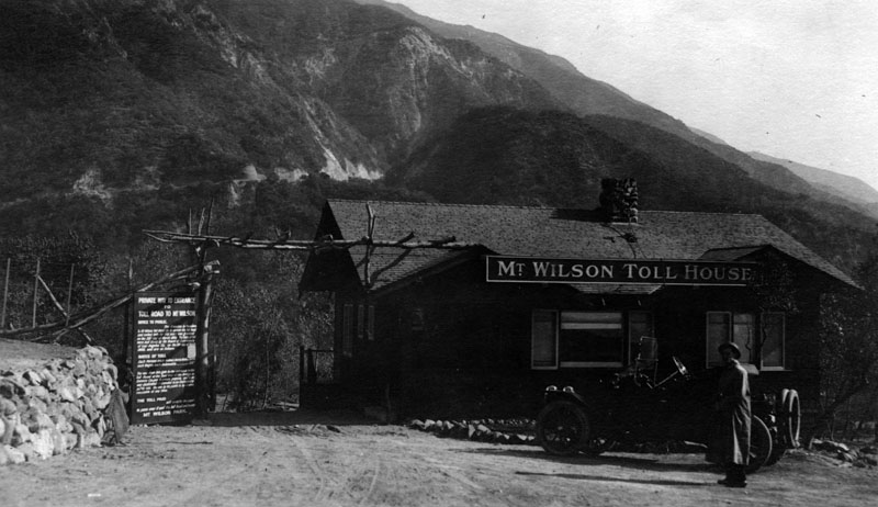
| (ca. 1917)* - Close-up view of the Mt. Wilson Toll House. Sign on left reads, "Private way to entrance to toll road to Mount Wilson." |
Historical Notes In July, 1891 the new toll road was officially opened to the public and the toll fixed by the Los Angeles County Board of Supervisors at 25 cents for hikers and 50 cents for horseback. The new road was called the "New Mt. Wilson Trail", and it soon became more popular than the old Sierra Madre trail. Foot and pack animal traffic became so heavy that in June 1893 the trail was widened to six feet, making two way travel much easier. |
 |
|
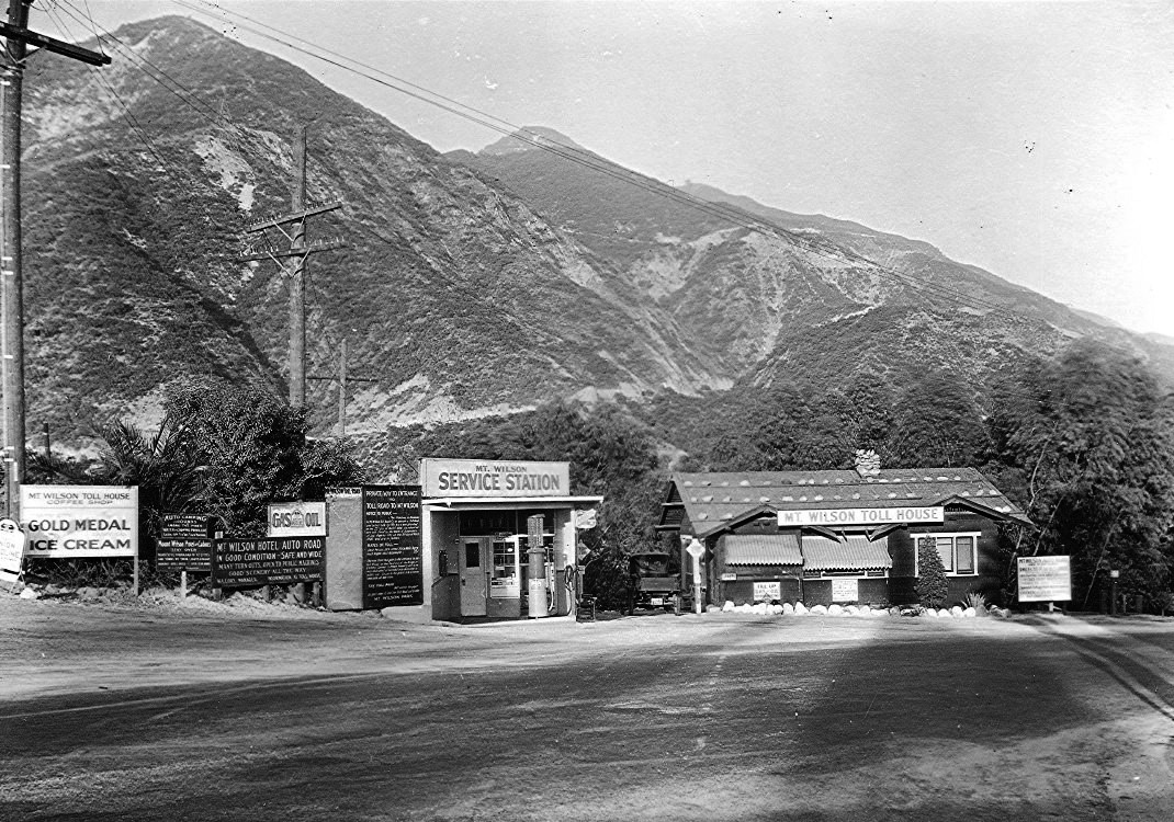
| (ca. 1920)* - View showing the Mount Wilson Toll Road, Toll House and Service Station. The Toll Road rises at rear. |
Historical Notes The Mount Wilson Toll Road ascended Mount Wilson via a vehicular passable road from the base of the foothills in Altadena. It was accessible from Pasadena via Santa Anita Avenue (nowadays the north-south portion of Altadena Drive) which drove right to the front porch of the toll house. When the Toll Road closed in 1936, the first 1/2 mile was sold off as residential lots and the entrance to the road moved to its present location on Pinecrest Drive. |
 |
|
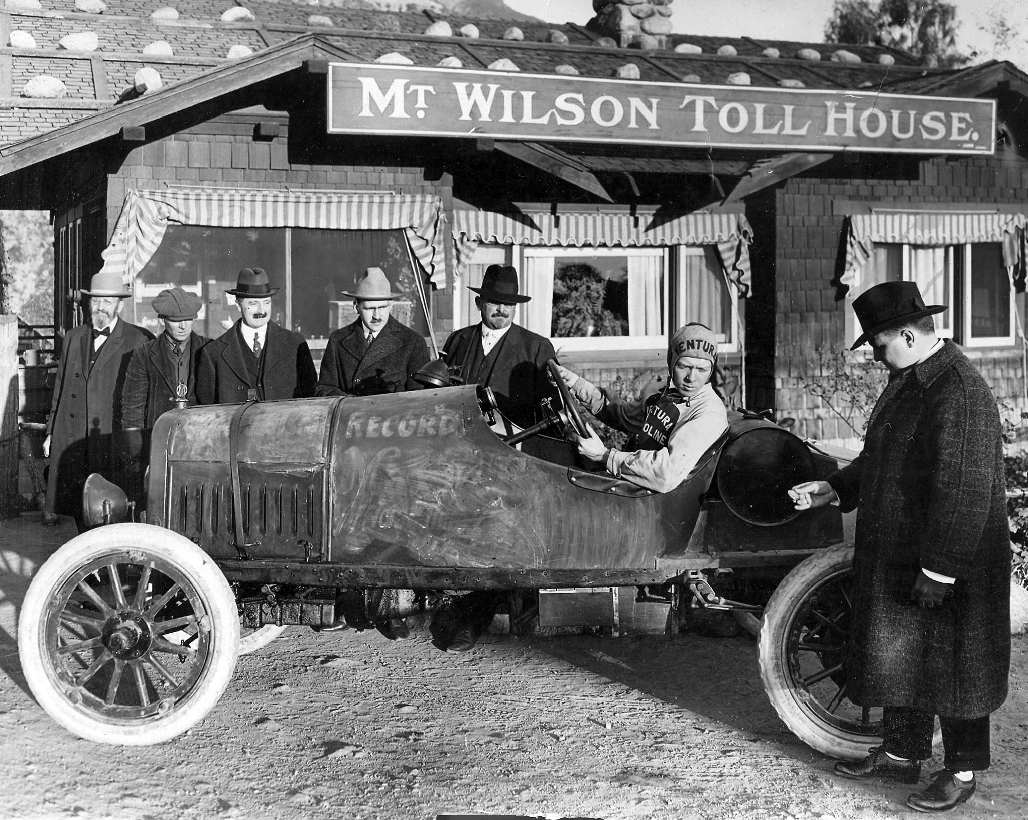
| (ca. 1915)++# - View showing a 1915 Maxwell about to make an ascent on Mt. Wilson Toll Road with the Toll House at rear. Note the man holding the watch, presumably to time round trip. |
Historical Notes The Maxwell was a brand of automobiles manufactured in the United States from about 1904 to 1925. By 1914 the company sold 60,000 cars. They became known for their speed from some racing contests. The present-day successor to the Maxwell Company is Chrysler Group. |
 |
|
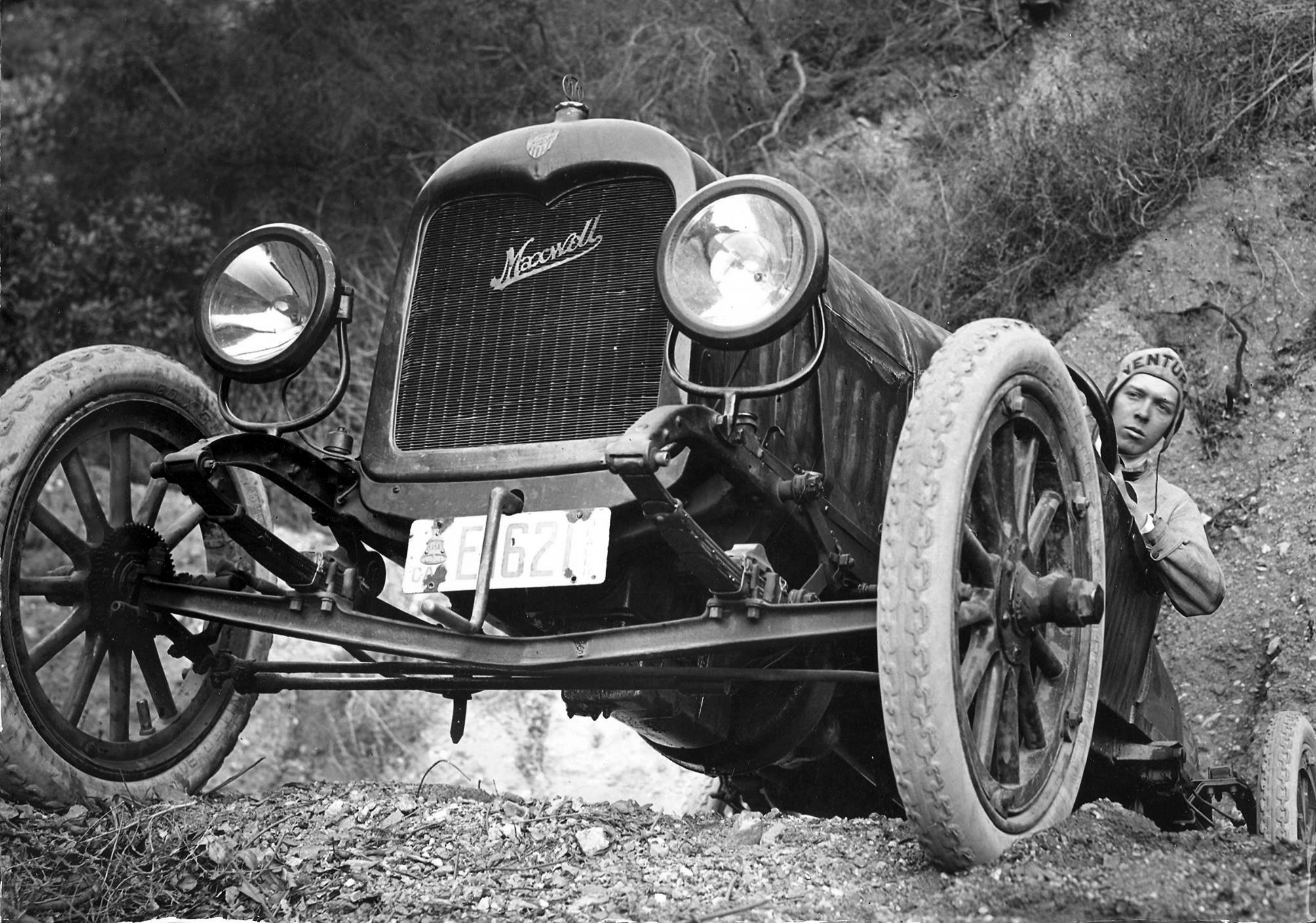
| ca. 1915)++# - A view of the Maxwell during its ascent on the Toll Road. |
 |
|
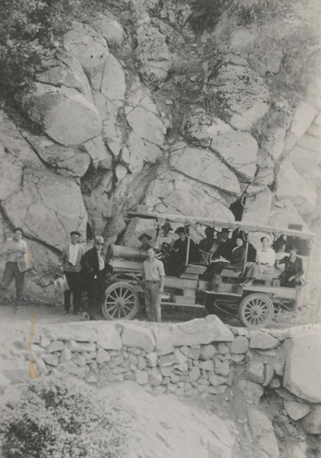
| (1918)* - A tourist bus on the road up Mount Wilson in Los Angeles County. |
Historical Notes By the early 1930s a new high speed highway was being built from La Cañada via the Arroyo Seco. The new Angeles Crest Highway was paved and ready for travel into Red Box Canyon and onward to Mt. Wilson from the back side by 1935. The historic Mt. Wilson Toll Road closed to the public in March, 1936 and was turned over to the United States Forest Service. Today, the Old Mt. Wilson Toll Road is still accessible to non-motorized traffic (hikers, bicyclists, and horses) by way of Eaton Canyon (either from the Nature Center entrance, or an access gate on Pinecrest Drive, just off Altadena Drive in Altadena). Segments of it have been closed at various times due to landslides. A 2005 landslide destroyed 50 yards of the road, but it has since been rebuilt and reopened. |
* * * * * |
Mount Wilson Hotel
 |
|
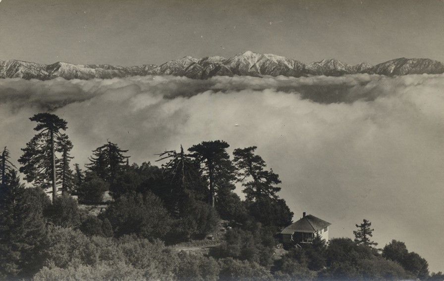
| (1910s)* - View across clouds to mountains from Mount Wilson with the first Mount Wilson Hotel seen at lower right. Photo by Bob Plunkett |
Historical Notes The Mt. Wilson Hotel was a popular resort in the early 20th century, located near the Mt. Wilson Observatory which was undergoing major improvements at the time. The hotel was frequently taxed to its limits, with 50 men having to stay up all night in the dining room at one point in 1907. |
 |
|
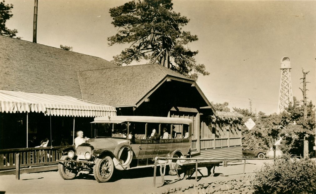
| (ca. 1920s)* - Postcard view showing the Mount Wilson Stage Line outside Mount Wilson Hotel. In background stands one of the solar towers. |
Historical Notes When the automobile craze surged in the 1920s, families were finally able to reach the summit on four wheels. Driving up the harrowing Mountain Wilson toll road, which was open to the public from 1912 to 1936, deposited weekend adventures at the doorstep of the Mount Wilson Hotel. Rebuilt after burning down in 1913, the hotel, complete with a dining room and swimming pool, was a popular lodging for Southern Californians. |
 |
|
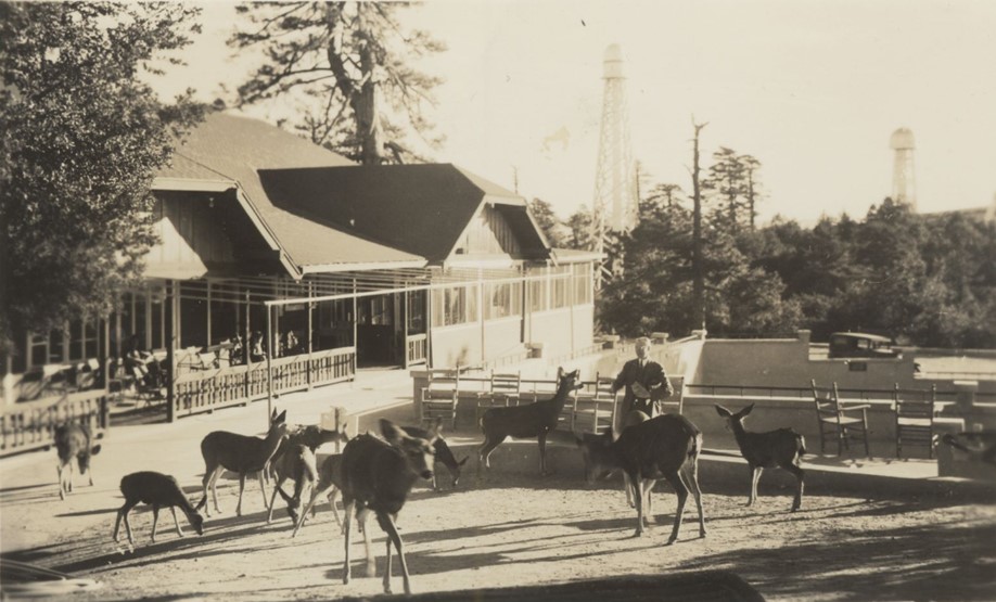
| (1941)* – Postcard view showing a man feeding deer at the Mt. Wilson Hotel. In the background can be seen two solar towers of the Mt. Wilson Observatory. |
Historical Notes The hotel faced recurring challenges over the years, including wildfires, cottage fires, and battles over control of the surrounding land with operators like Charles Chantry and the McNallys of the Orchard Camp. The landmark hotel would be torn down in 1966. |
 |
|
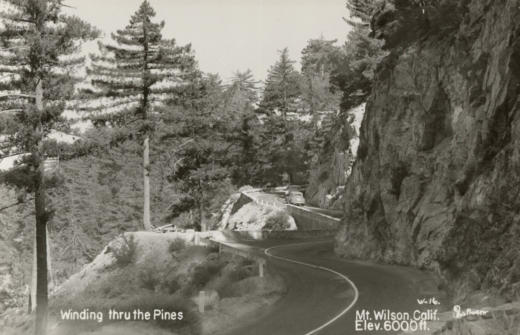
| (1940s)* – Postcard view showing cars on the winding road up to Mt. Wilson. Photo by Bob Plunkett |
Historical Notes The road up to Mount Wilson today is known as the Mount Wilson Red Box Road, and it provides access to the Mount Wilson Observatory and other facilities at the summit. The road starts from the Angeles Crest Highway and is 4.7 miles long, with an elevation gain of 1027 feet. The average gradient of the road is 4.14%, making it a challenging and scenic drive. |
Angeles Crest Highway
 |
|
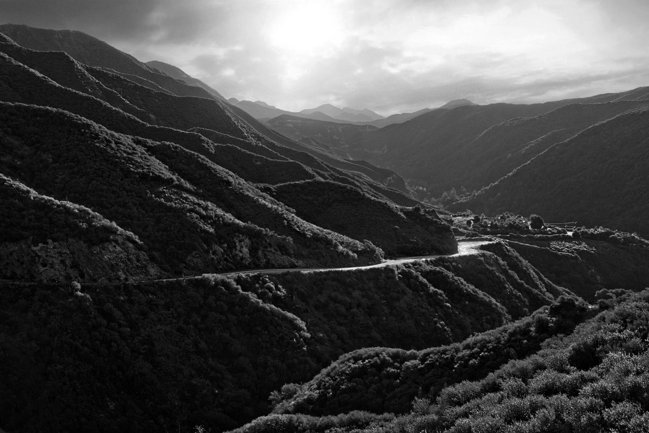
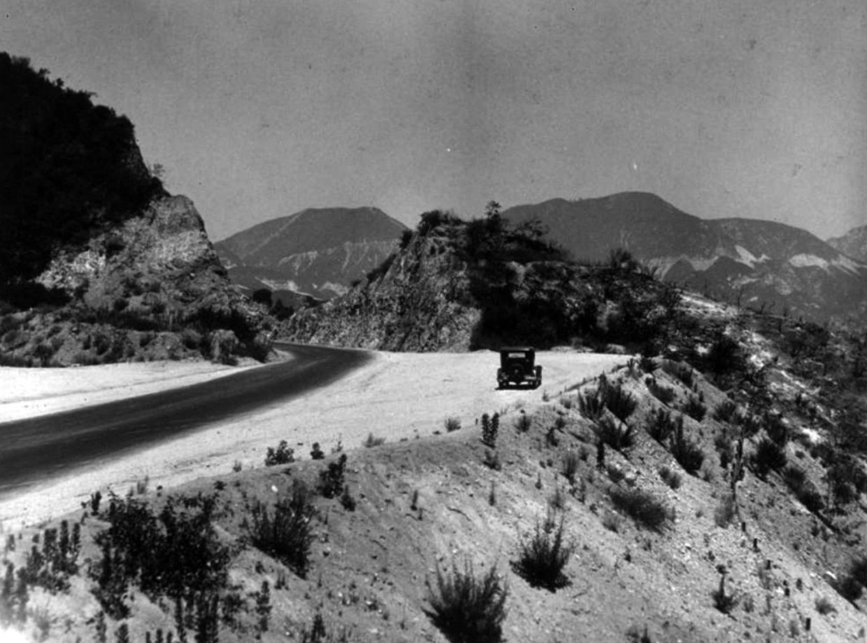
| (n.d.)* – View looking down at Angeles Crest Highway as it winds its way through the scenic Angeles National Forest. |
Historical Notes Engineer J. B. Lippincott surveyed the highway for the Automobile Club of Southern California in 1919. This is the same Lippincott that surveyed the Los Angeles Aqueduct for William Mulholland. When finished, the scenic byway would ascend up and wind its way through 66 miles of the Angeles National Forest, through chaparral, and montane forest habitats, along the highest and most scenic ridges of the San Gabriel mountain range. |
 |
|
| (1934)*#* - The Angeles Crest Highway was meant to connect with the San Gabriel Canyon Road to create a scenic loop. The loop was eventually completed but was severed by a landslide in 1978. |
Historical Notes The concept for "the most scenic and picturesque mountain road in the state" was developed in 1912, and the funding allocated beginning in 1919. The construction, piece by piece, started in 1929 and continued until 1956, with the exception of the years 1941 through 1946 during WWII. * |
 |
|
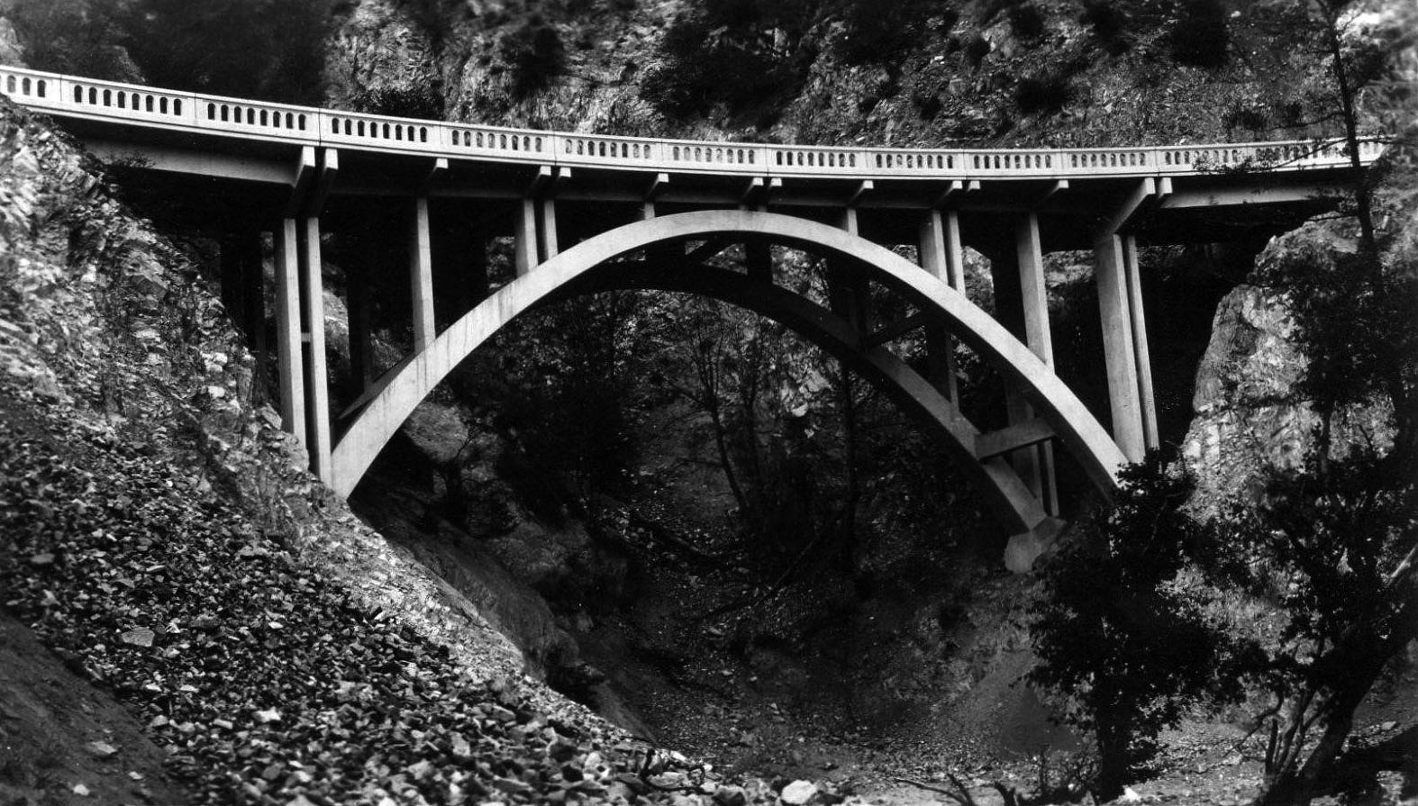
| (1931)#++ - Postcard view showing the Slide Canyon Bridge just after its construction. It would take another 25 years to complete the entire 66 miles of the Angeles Crest Highway. |
Historical Notes Where nature failed to provide a way, workers created one, blasting roadcuts into granite and erecting bridges over drainages. Some cuts are as deep as 240 feet. |
 |
|
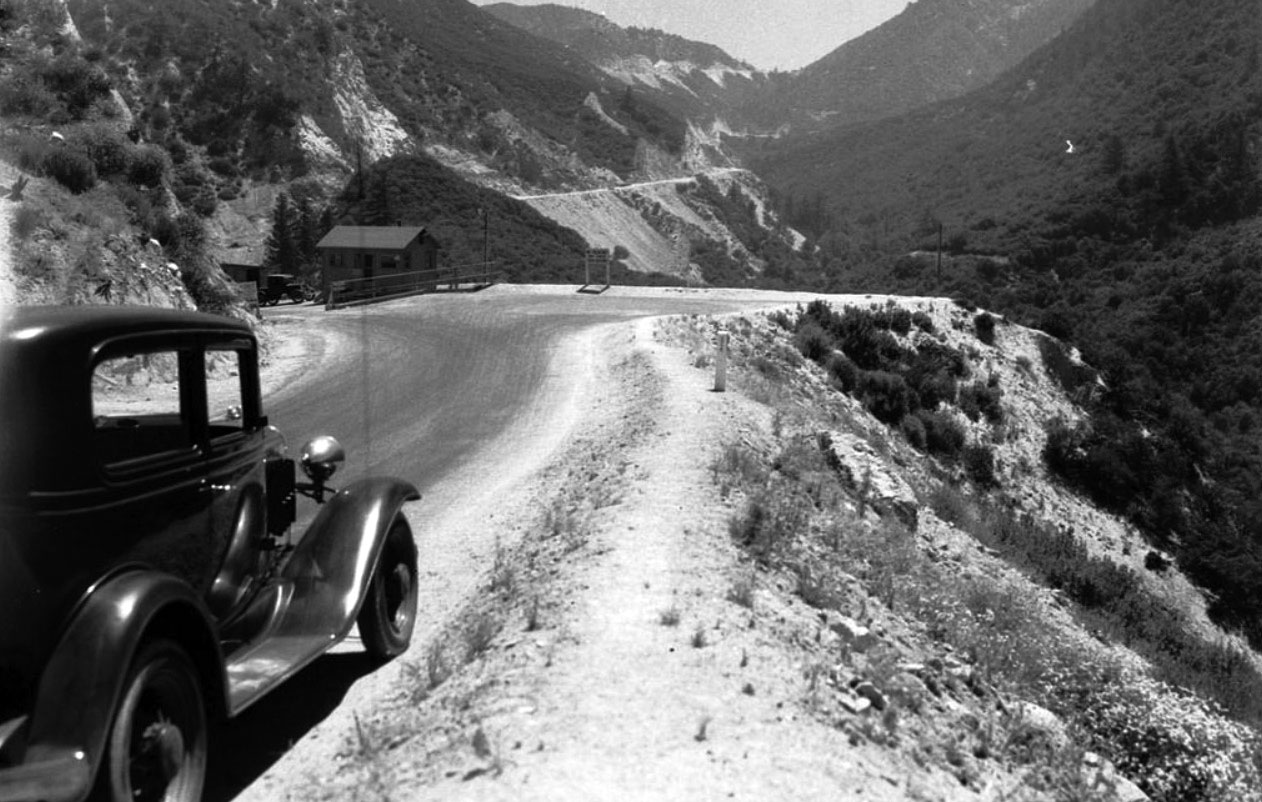
| (1934)* - The Angeles Crest Highway includes several scenic turnouts as it climbs the Arroyo Seco drainage toward Red Box. |
 |
|
| (1934)*#* – View showing the Angeles Crest Highway between Colby Canyon and Red Box. Photo courtesy of the Automobile Club of Southern Calfiornia Archives. |
 |
|
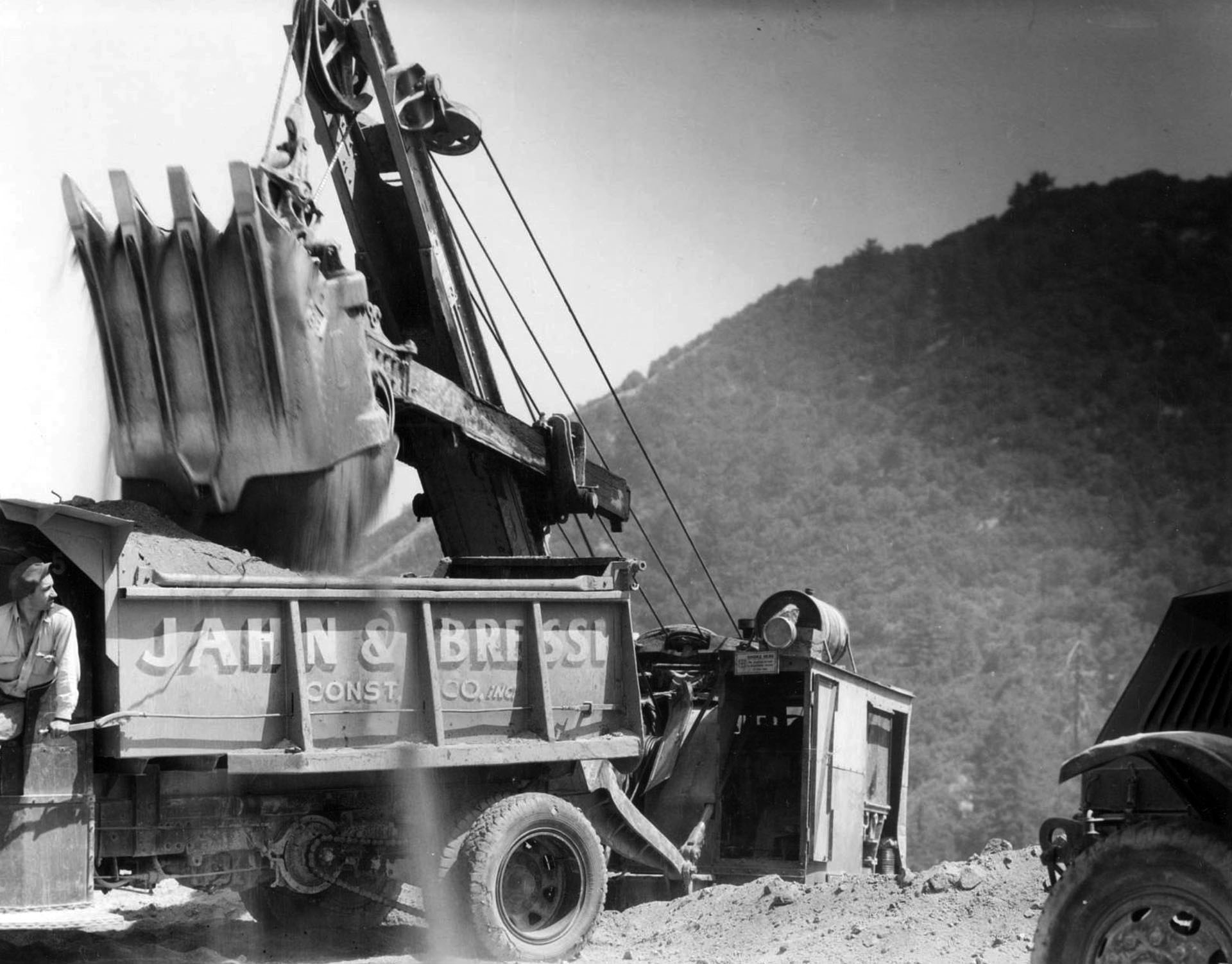
| (n.d.)^ - Convicts were an essential part of the Angeles Crest Highway construction workforce, but private contractors performed heavy lifting, too. |
Historical Notes Construction of Angeles Crest Highway began in 1929. It was originally intended to be a fire access road. In 1941 construction stopped because of World War II. In 1946, after the war, construction resumed; the completed highway eventually opened in 1956. The road was constructed by prison labor from Camp 37, which has since been razed. Division of Highways (now known as CalTrans) staff lived at a site called Cedar Springs. The staff is now located at Chilao Flats. Children of the staff attended Chilao Mountain School, a one-room school; the school has been closed for several years. |
Angeles Crest Tunnels
 |
|
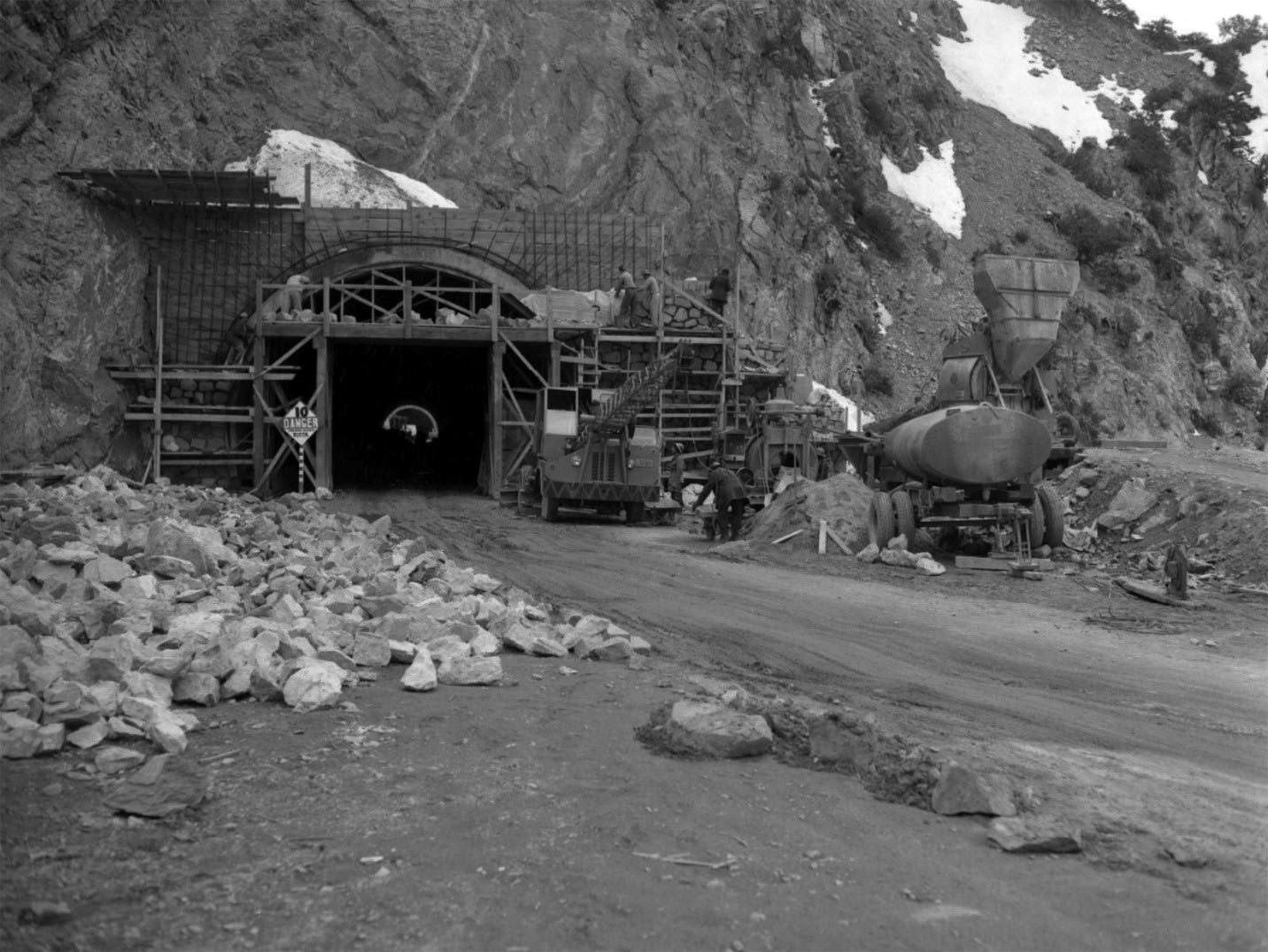
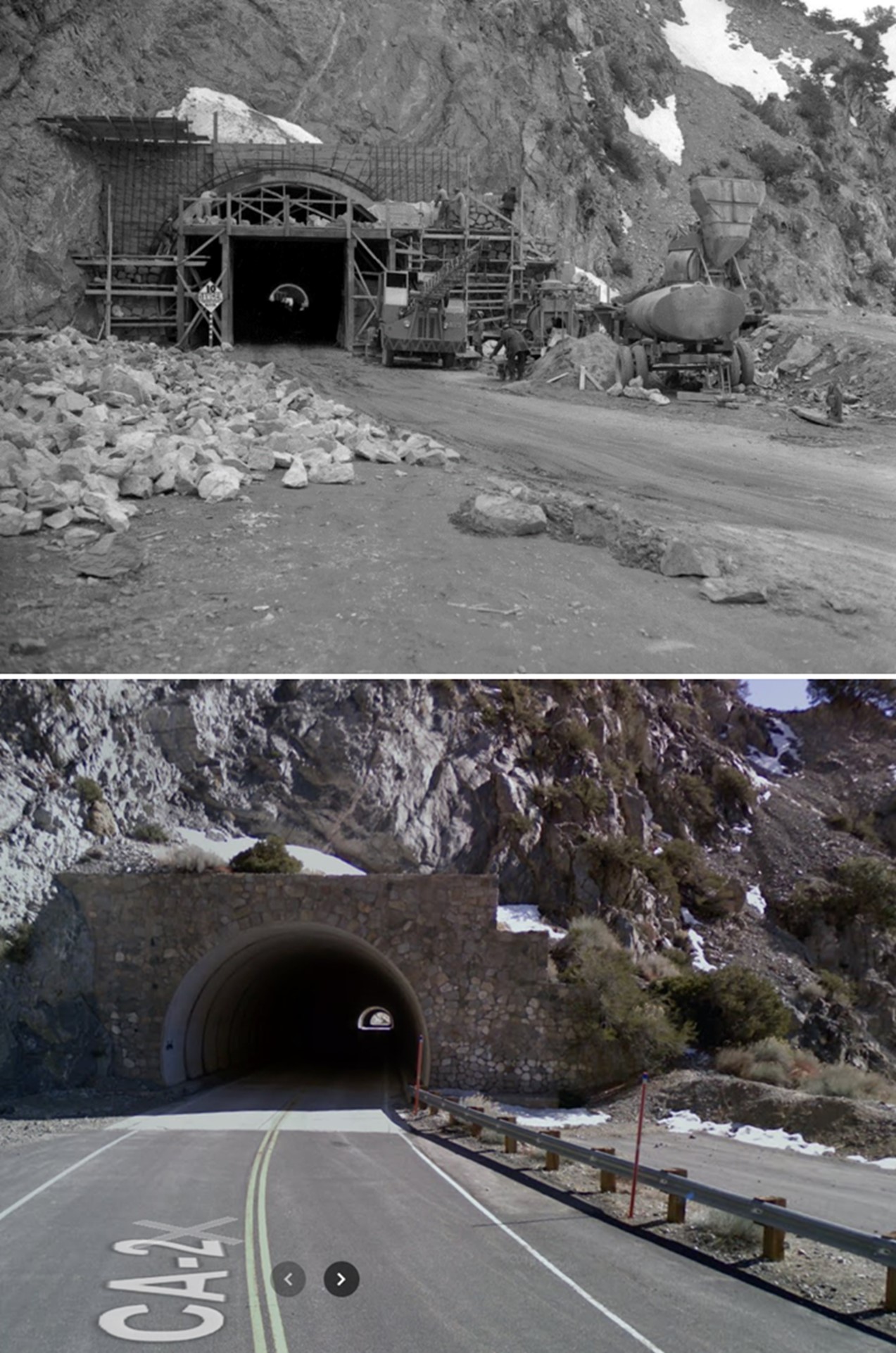
| (1949)* – View showing the construction work on two highway tunnels, measuring 680 and 470 feet in length, in the San Gabriel Mountains high country, a short distance east of Cedar Springs. Los Angeles Times Photo Archive, UCLA Library. |
Historical Notes In the high country near Islip Saddle, the highway tunnels twice through the mountainside. It achieves its highest elevation, 7,901 feet, at Dawson Saddle. |
 |
|
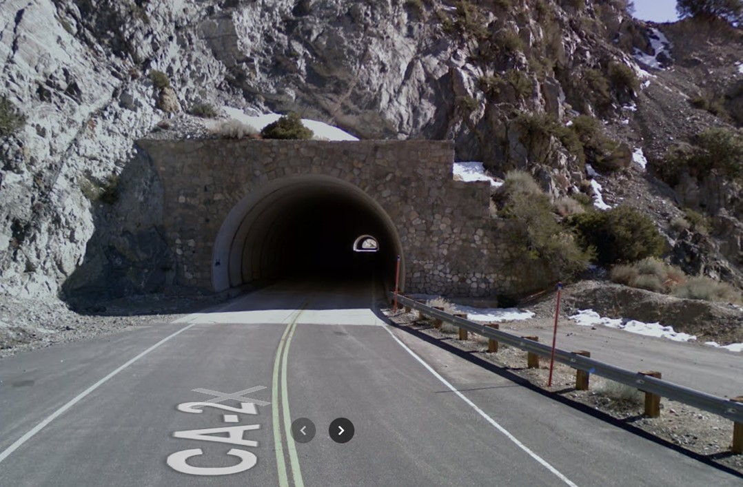
| (2009)* – Contemporary view of the Angeles Crest Tunnels. |
Then and Now
 |
|
| (1949 - 2009)* – Angeles Crest Highway (SR-2) in the high country near Islip Saddle, where the highway tunnels twice through the mountainside. The tunnels measure 680 and 470 feet in length and are located a short distance east of Cedar Springs at an elevation of 6680 feet. |
 |
|
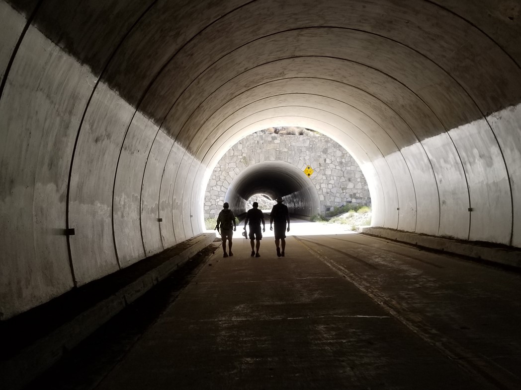
| (2018) – After completing a long hike in the San Gabriel Mountains and finding ourselves a couple of miles from our original starting point, we head through the Angeles Crest Tunnels in search of our car. Photo by Jack Feldman |
 |
|
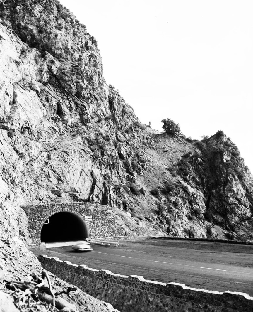
| (1956)^ – A car passes through one of the tunnels of Angeles Crest Highway. Los Angeles Examiner Collection |
Historical Notes Angeles Crest Highway was originally planned to be upgraded to a freeway in the 1950s, but was later considered geographically improbable and the plans were abandoned. |
 |
|
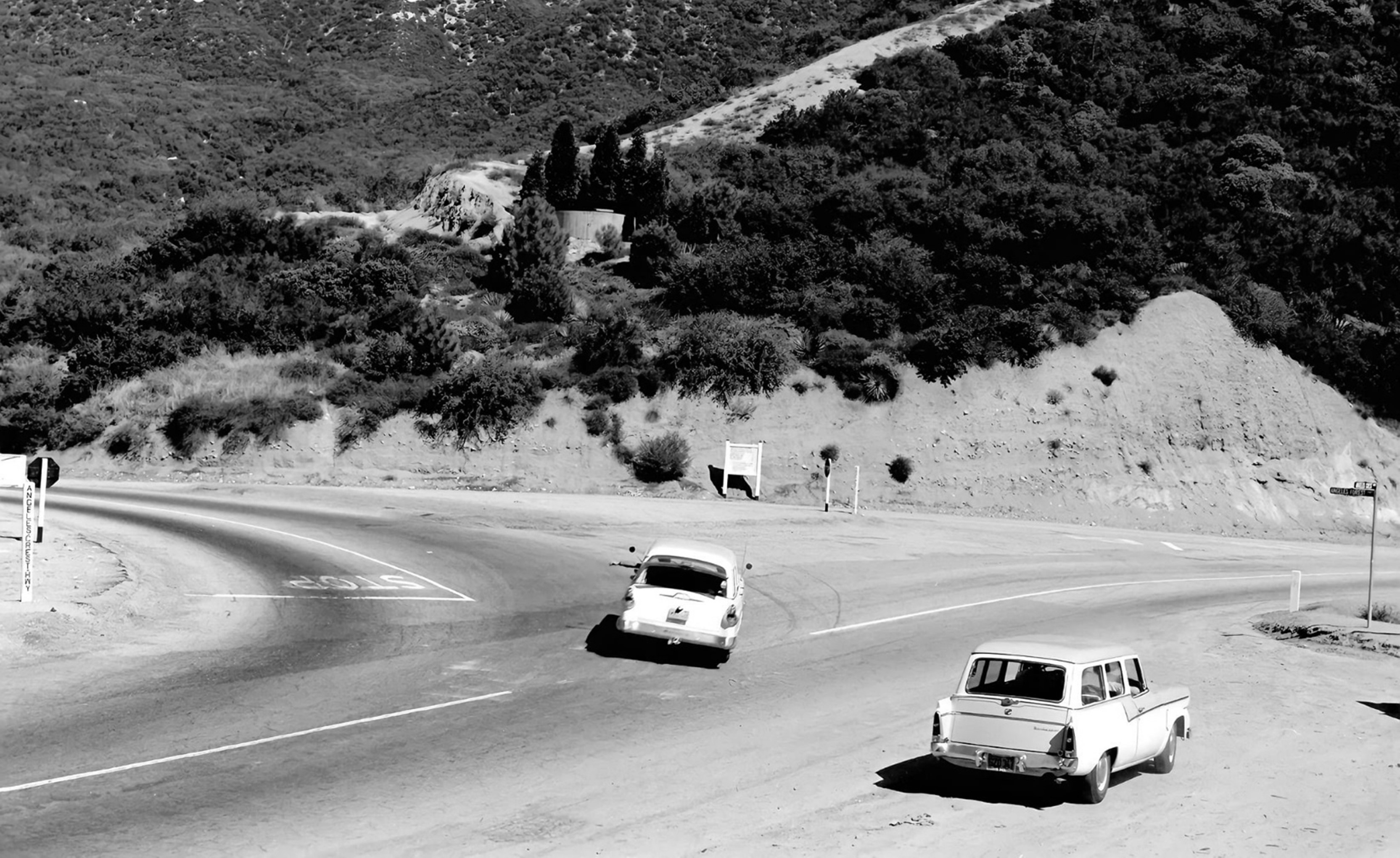
| (1956)* - Angeles Crest Hwy (CA-2) at Angeles Forest Hwy turnoff. View is looking north. |
 |
|
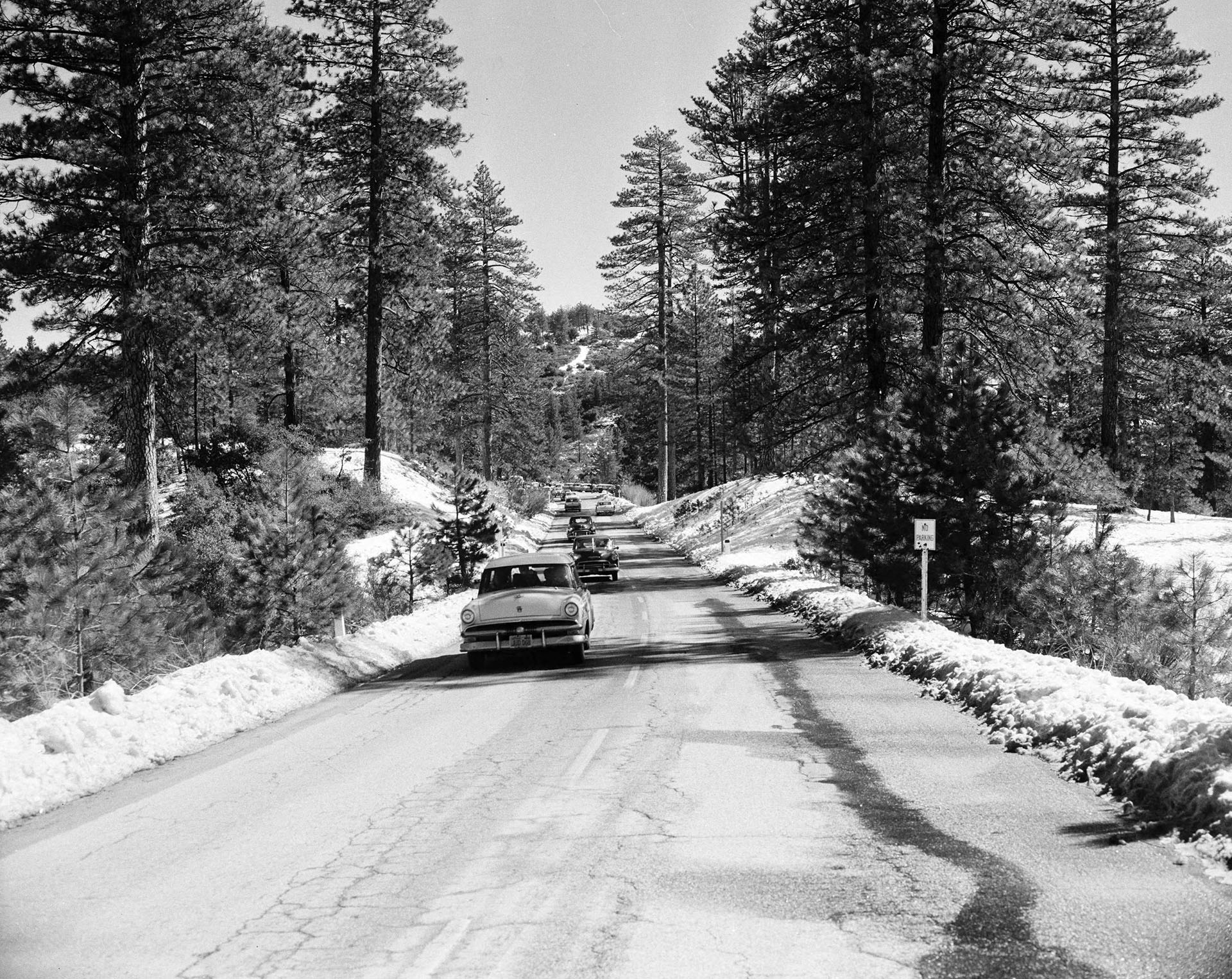
| (1959)^ – Snow on Angeles Crest Highway. The road crosses a remote backcountry once accessible only by a trip of several days on foot or horseback. |
Historical Notes The highway forever changed the Angeles National Forest. Almost immediately after the first segment opened, automotive visitors flooded trail resorts like Switzer’s or forested hideaways like Chilao previously accessible only by foot or horseback. In the 18 months between July 1932 and Dec. 1933, nearly 2.5 million people visited the Angeles National Forest – more than all visitors to California’s national parks combined. As construction extended the road toward Big Pines (which it finally reached in 1956), Civilian Conservation Corps (CCC) campgrounds drew even more visitors deep into the San Gabriels’ remote backcountry. Today, a motorist can traverse 66 miles of some of the most difficult terrain in the U.S. in under two hours, through country that once provoked complaints from no less a mountaineer than John Muir. “In the mountains of San Gabriel,” Muir wrote, “Mother Nature is most ruggedly, thornily savage.”* |
* * * * * |
Please Support Our CauseWater and Power Associates, Inc. is a non-profit, public service organization dedicated to preserving historical records and photos. Your generosity allows us to continue to disseminate knowledge of the rich and diverse multicultural history of the greater Los Angeles area; to serve as a resource of historical information; and to assist in the preservation of the city's historic records.
|
More Historical Early Views
Newest Additions
Early LA Buildings and City Views
History of Water and Electricity in Los Angeles
* * * * * |
References and Credits
* LA Public Library Image Archive
^*California Historic Landmark Listing (Los Angeles)
^^UC Irvine - The White City by Miles Clement
*# The Shakespeare Club of Pasadena
+# Examiner.com - Rose Parade no-nos: Sundays, rain, Supreme Court Justices
#* Huntington Digital Library Archive
## Google Maps
*^#CSUN Oviatt Library Digital Archives
**^Colorado Street Bridge nps.com
*^^Nuestra Señora la Reina de los Ángeles: losangelespast.com
^^*LA Times Framework: 1918 Rose Parade; In 1949, the Snowman Socked LA
^*#Noirish Los Angeles - forum.skyscraperpage.com; Devil's Gate; Colorado St. Bridge; Maryland Hotel
^##California State Library Image Archive
+##Weird California: Los Angeles' Programmatic Architecture
###Library of Congress: Hotel Green Panoramic, ca. 1908
**#Metro Transportation Library and Archive
#**Palomar Observatory - Caltech.edu
*#*KCET: Scoville Bridge; Rise of the Sierra Madre
^#^LAghostpatrol.com: Devil's Gate
^.^Facebook: SoCal Historic Architecture
^#*ArroyoSeco.org: Devil's Gate
^^^Atlasobscura.com: Devil's Gate
*^*^Earlyaviators.com: Roy Knabenshue
^*^*Mtwilson.edu: Mount Wilson Observatory
^*^#Facebook.com - Bizarre Los Angeles
*^^*Pasadena: A Busines History
*^^^San Fernando Valley Historic Society/Facebook.com: Wagon Trip
^^*#Facebook.com - Pasadena Digital History
*#*^Denver Public Library Image Archive
*#*#Downtown Pasadena's Early Architecture
^#^^Calisphere: University of California Image Archive
#*#*OldRadio.com; The Story of Mt. Wilson
#^#^Los Angeles Magazine: The Dammed Past of Devil's Gate
##^^Flickr.com: Michael Ryerson
##^*Los Angeles Daily News: Castle Green
##**Electric Railway Historical Association; Pacific Electric
^^^^*Bureau of Street Lighting Image Archive
*^ Wikipedia: History of Pasadena; Tournament of Roses Parade; The Langham Huntington; Hotel Green; Rose Bowl Game; Pasadena City Hall; Old Town Pasadena; Los Angeles Terminal Railway; Richard H. Chambers United States Court of Appeals and the Vista del Arroyo Hotel and Bungalows; California Institute of Technology; Mt. Lowe Railway; Cawston Ostrich Farm; Pacific Electric Railway; Arroyo Seco - Devil's Gate; Mt. Wilson Toll Road; Mt. Wilson; Merritt Mansion; Raymond Hotel; California Cycleway
< Back