Early Views of Santa Monica
Historical Photos of Early Santa Monica |
 |
|
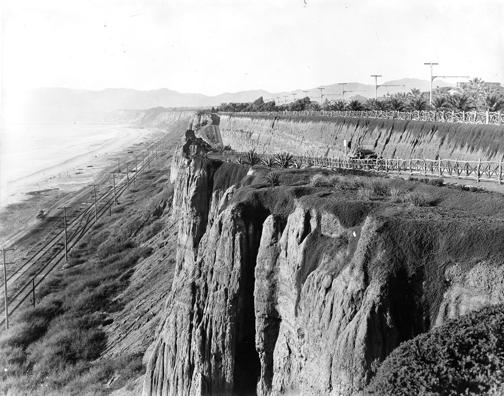
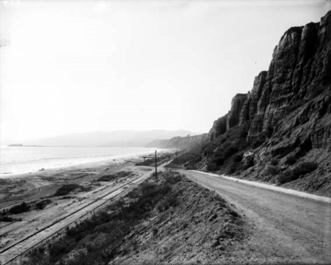
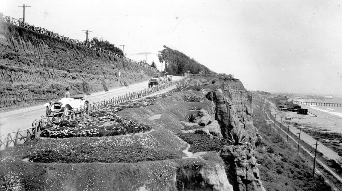
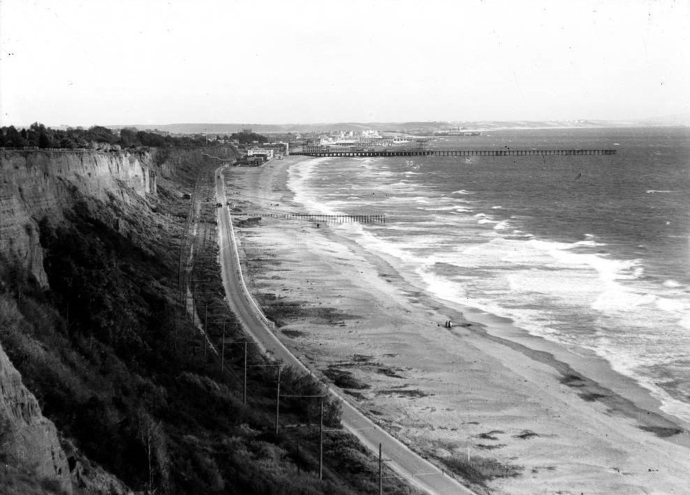
| (ca. 1905)* - View of the Santa Monica shoreline from Palisades Park. The tracks of the Los Angeles & Independence R.R. run where Pacific Coast Highway is today. To the right, a motorcar ascends an early version of the California Incline. |
Historical Notes Footpaths like the Sunset Trail and stairways like the 99 Steps preceded it, but the California Incline was the first automobile shortcut over Santa Monica’s ocean bluffs. When it opened around 1905, Linda Vista Drive (as it was then called) was a dirt path carved into the cliffside. Only later was it paved and named for its intersection with California Avenue. * |
 |
|
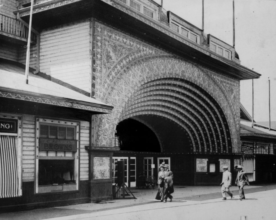
| (ca. 1905)** - Early view looking up the California Incline leading from the coast highway to the palisades. There is a walking path to the right of the road. |
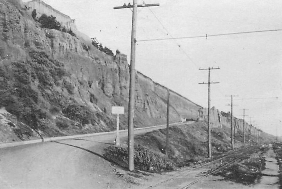
Historical Notes Today, the California Incline is a vital street in Santa Monica, linking the PCH with Ocean Avenue, and California Avenue, bisecting Palisades Park. It begins at an intersection with Ocean Avenue and California Avenue, at the top of the palisades, extending to the PCH at the base of the bluffs. |
 |
|
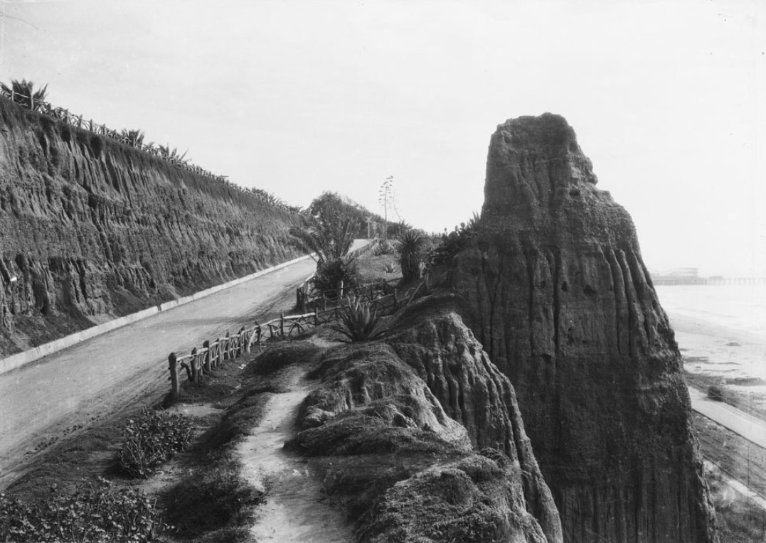
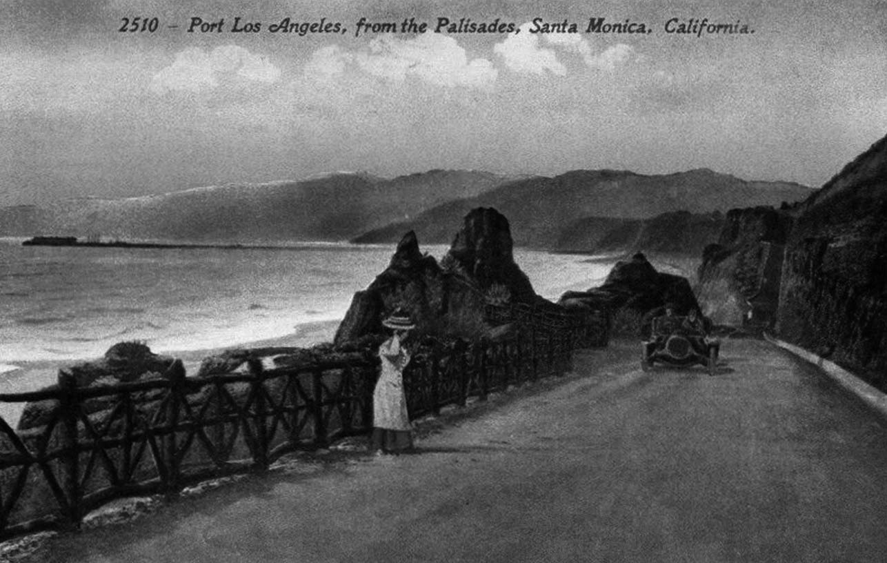
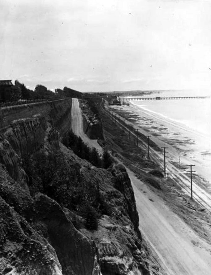
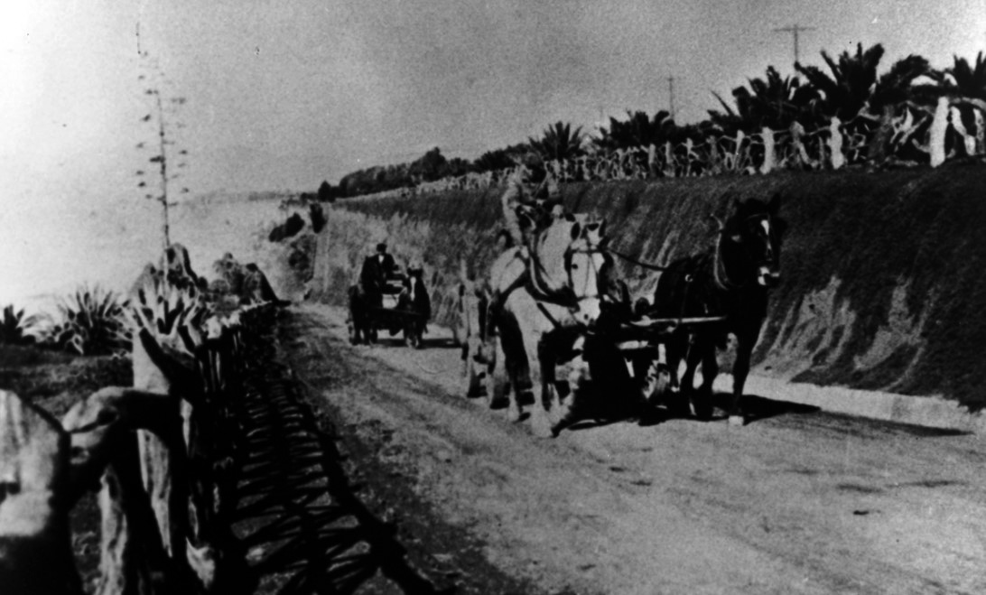
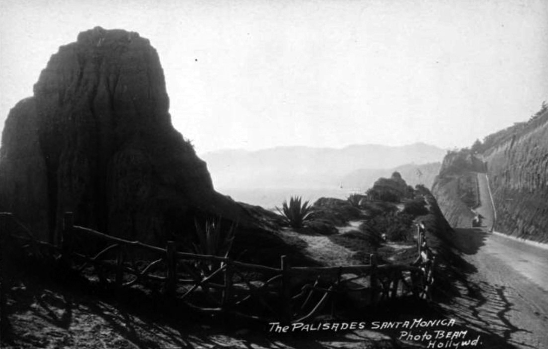
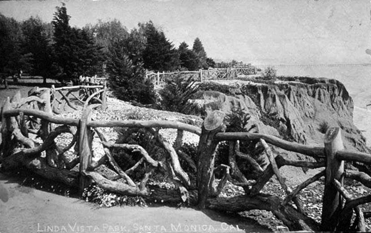
| (ca. 1905)* - View shows a wooden fence along an unpaved California Incline with the Long Wharf seen in the background. The Santa Monica mountains are in the distance. Linda Vista Park (later Palisades Park) is on the right. |
Historical Notes Originally known as “Linda Vista Park,” Palisades Park was the first officially-designated public open space in Santa Monica. The land was donated to the City by Santa Monica's founder, Senator John P. Jones, in 1892. Additional land was donated by the Santa Monica Land and Water Company. The park was designed by I.E. Le Grande in 1913. It features Craftsman-era stone gates with tiles designed by Ernest Batchelder, picnic areas, a rose garden and scenic overlooks. |
 |
|
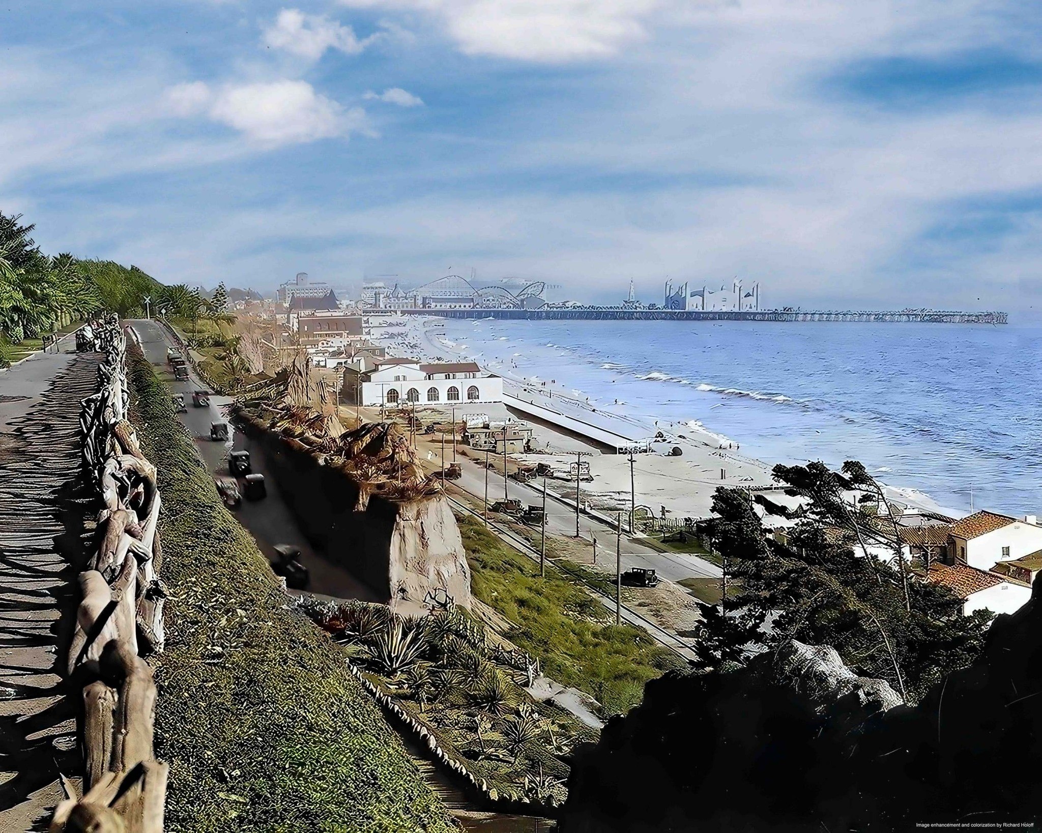
| (ca. 1905)* - View shows a wooden fence along an unpaved California Incline with the Long Wharf seen in the background. The Santa Monica mountains are in the distance. Linda Vista Park (later Palisades Park) is on the right. Image enhanced and colorized by Richard Holoff. |
 |
|
| (ca. 1910)^*## – Postcard view showing a woman standing on the California Incline watching a car as it makes its way up the grade. The Long Wharf can be seen in the background. |
Historical Notes The Long Wharf was built in 1893 at the north end of Santa Monica to accommodate large ships and was dubbed Port Los Angeles. At the time it was constructed, it was the longest pier in the world at 4700 feet, and accommodated a train.*^ However, just a short four years after the Long Wharf's construction, San Pedro Bay was chosen over Santa Monica to be the main seaport of Los Angeles. Click HERE to see more in Early Views of San Pedro and Wilmington. |
 |
|
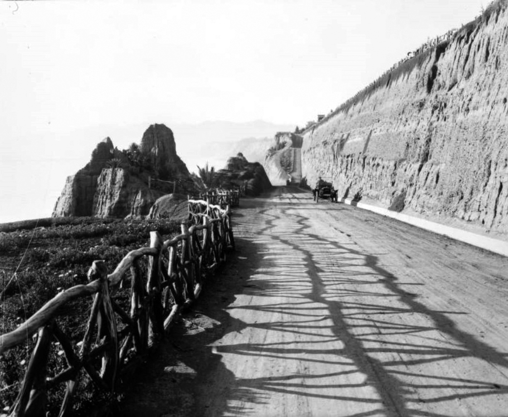
| (1910s)^ – View showing an automobile driving south up the California Incline in Santa Monica. The rustic fence is on the left, and the bluffs on the right. Note the pedestrian trail at center-top. |
 |
|
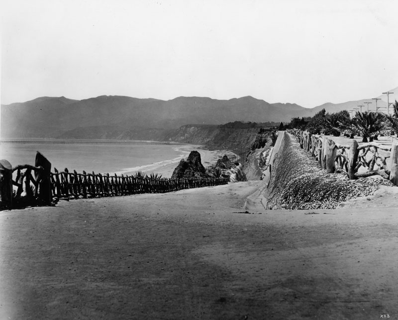
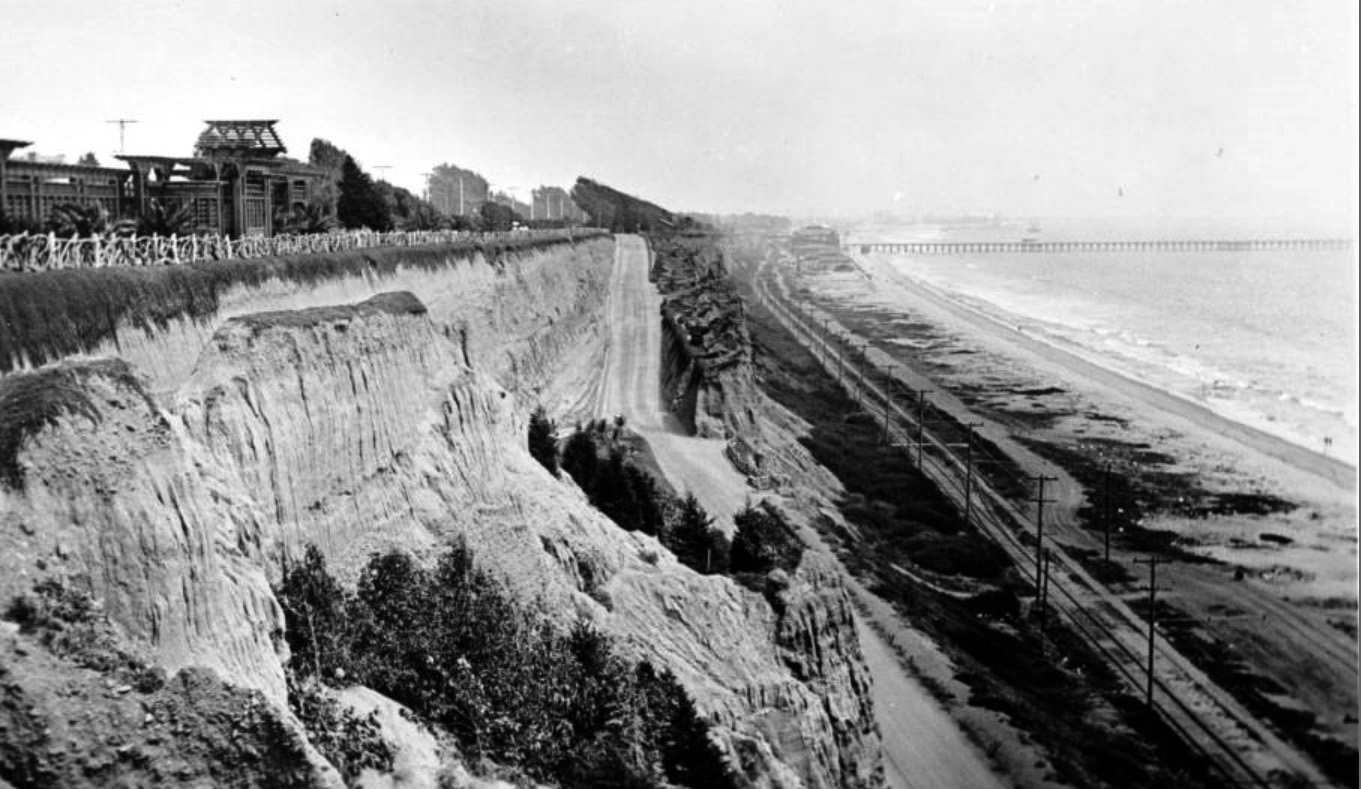
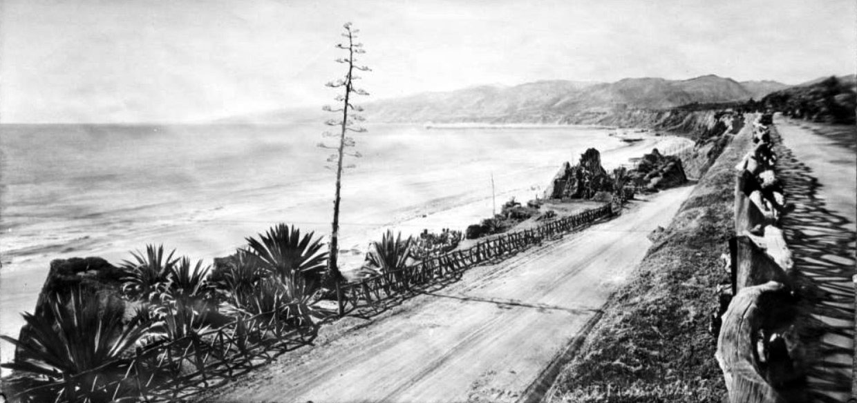
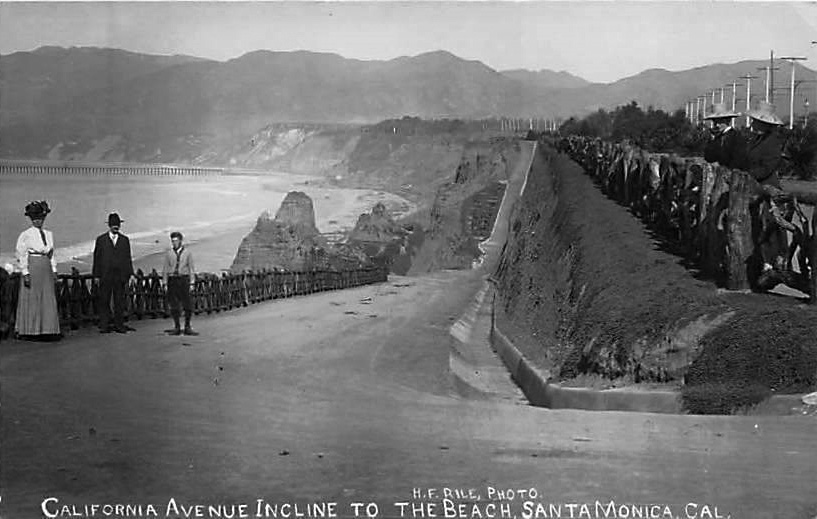
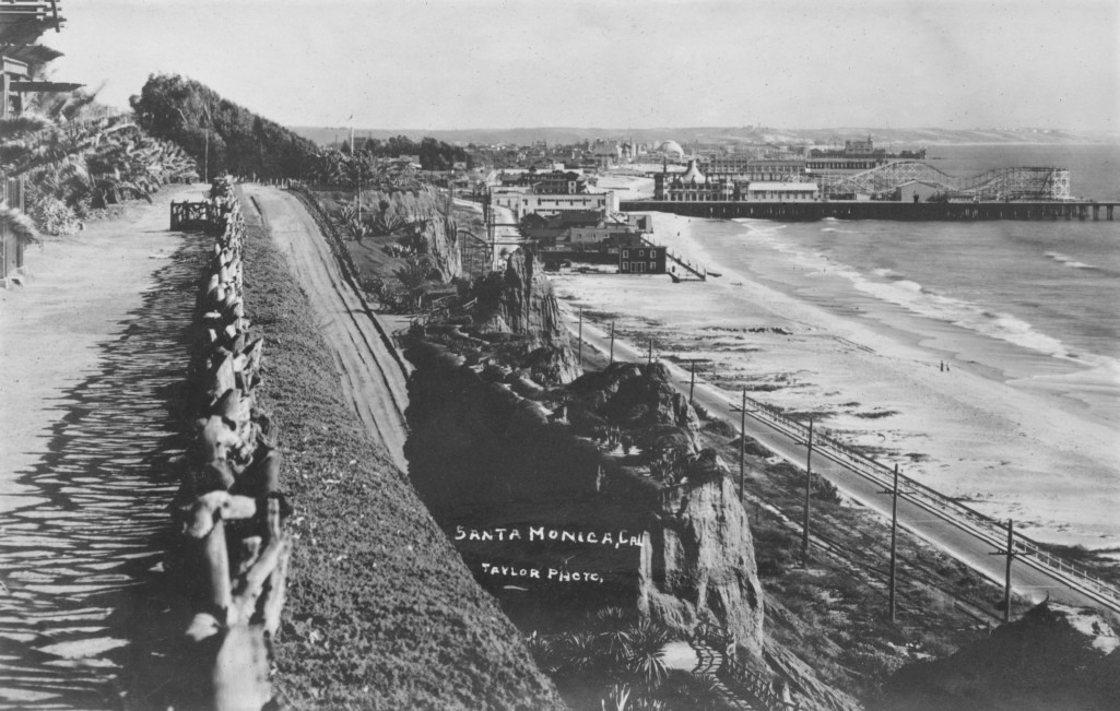
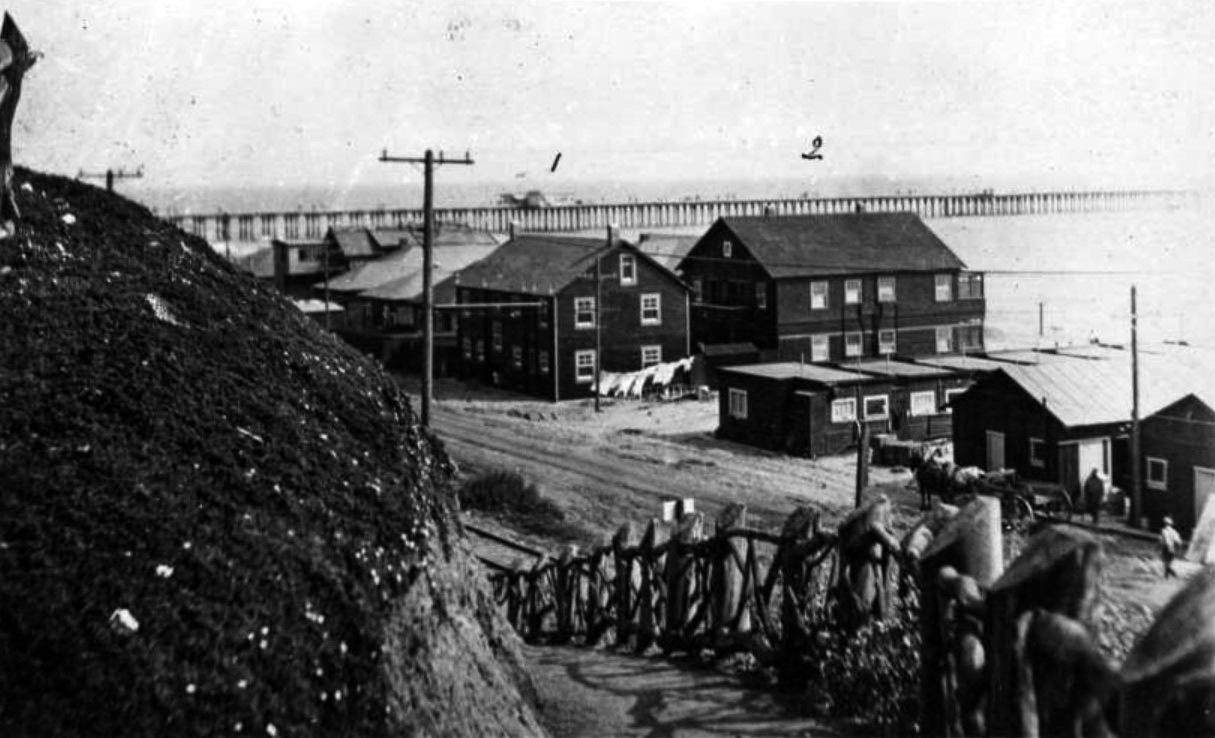
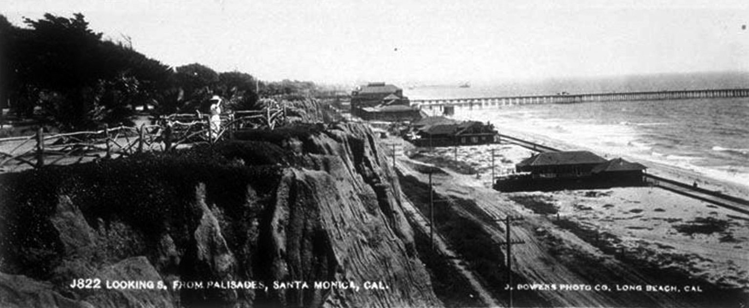
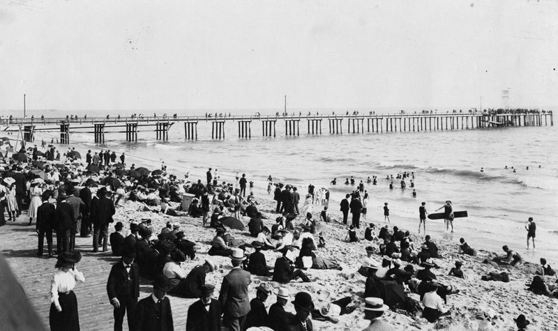
| (ca.1910)* - View showing the Santa Monica coastline, looking south from Linda Vista Park (later Palisades Park). The palisades are at left and are a line of steep, rocky cliffs. A twisted wood fence runs along the top edge of the cliff, and several wooden structures can be seen beyond the fence. A wide unpaved road runs up the face of the cliffs at center. At right, the ocean is visible. A set of railroad tracks and Beach Road (later Roosevelt Highway and the Pacific Coast Highway) can be seen at center, running parallel to the shoreline down to where Santa Monica Municipal Pier (1909) juts out into the water. |
 |
|
| (1910s)^ - View from Palisades Park looking down a pedestrian trail that intersects the California Incline road, with the beach, and Santa Monica Pier and Ocean Park amusement piers in the background. Note the observation deck at right. |
 |
|
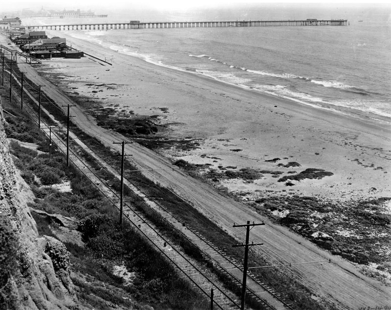
| (ca. 1905)#^^ - View looking down the California Incline road in Santa Monica towards the beach and railroad tracks. The Southern Pacific Railroad ran steam engines along these tracks between Los Angeles and the Long Wharf (seen in distance at left). A few telephone poles can also be seen, as well as the wagon trail that ran alongside the railroad tracks. |
 |
|
| (ca. 1910)^ - View looking south at the California Incline road coming down from the bluffs to the beach, in Santa Monica. The Santa Monica Municipal Pier (1909) is in the distance. Railroad tracks can be seen running along the beach road below. |
 |
|
| (1912)* – View looking up the California Incline from near the tracks along the beach. |
 |
|
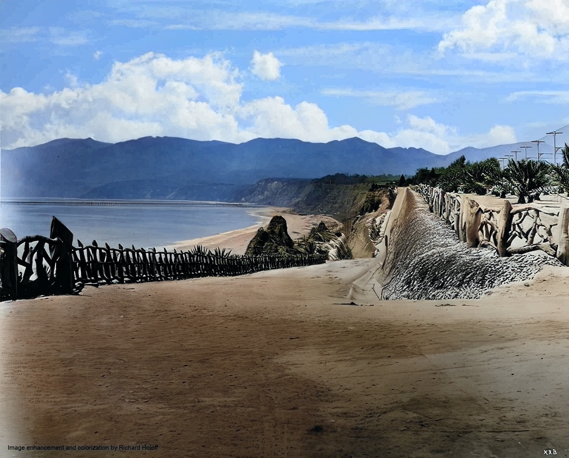
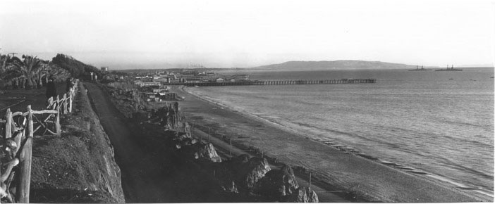
| (ca. 1913)** - Panoramic view of Santa Monica Beach looking north from the California Street incline. The ocean and shore are visible to the left, down from the cliff along which a paved road runs, lined to either side by a post-and-rail fence made from rough-cut branches. A second, higher road stands directly next to the first, at the right. Mountains are visible stretching out into the water in the background. Plants that appear to have been put there rather than growing naturally stand along the left side of the road. |
 |
|
| (1915)^#* – View of two horse-drawn wagons hauling freight up the California Incline. |
 |
|
| (1916)* – Photo of the California Incline showing a man next to an early model convertible taking on the view of the beach and ocean below. Also seen is a horse-drawn wagon making its way up the incline. LA Times Photo Archives |
 |
|
| (1910s)^ – Postcard view looking down the California Avenue Incline with the Long Wharf (1893 – 1920) seen in the distance. A man, a woman, and a child are posing for the camera at left. On the right, two people with ‘cool’ looking hats are standing behind the rustic wood fence at Linda Vista Park (Pacific Palisades Park in 1920). |
 |
|
| (ca. 1920)^^ - Panoramic view shows two people standing by the fence along Palisades Park looking south toward the Santa Monica Pier and the Palos Verdes Peninsula. Another person is seen walking along the fence-lined path. Two large ships are seen between the pier and peninsula. |
 |
|
| (ca. 1920)* - View looking down from Linda Vista Park (Palisades Park) showing the California Incline. A bit of the Camera Obscura on the left edge, with the Looff Hippodrome, Dome Theater, Roosevelt Highway (Pacific Coast Highway) seen below. |
 |
|
| (1920s)^ - Postcard view showing the California Incline and Palisades bluffs, lined with rustic wood fence, leading down to the beach at Santa Monica. |
 |
|
| (1924)^ - View showing two early model cars driving up the California Incline with pedestrian trail seen in the background. |
 |
|
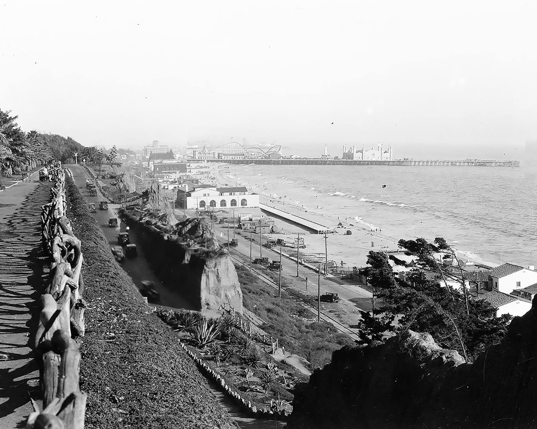
| (ca. 1925)* - California Incline with the Santa Monica Pier and Amusement Park in the distance. |
 |
|
| (ca. 1925)* - California Incline with the Santa Monica Pier and Amusement Park in the distance. Image enhancement and colorization by Richard Holoff. |
 |
|
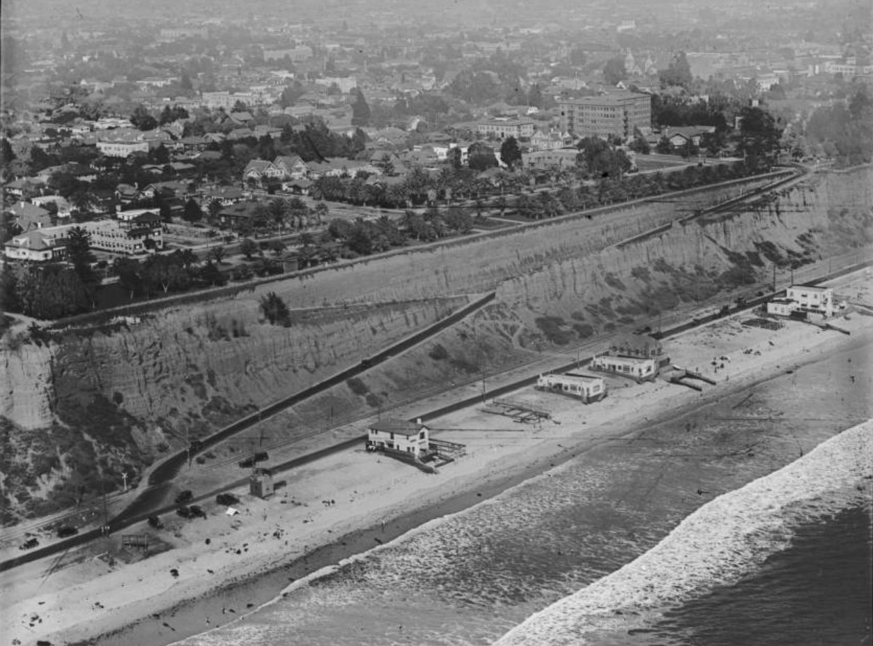
| (1920s)^ - Aerial view of the coastline in Santa Monica, showing the California Incline road running through the bluffs, with beach houses along the coast and Palisades Park and buildings above. |
 |
|
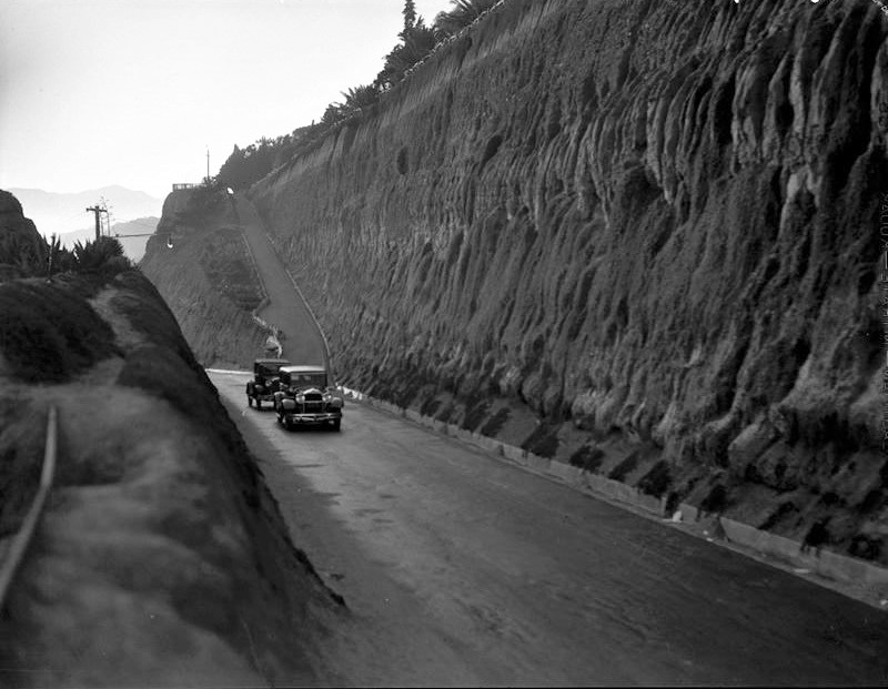
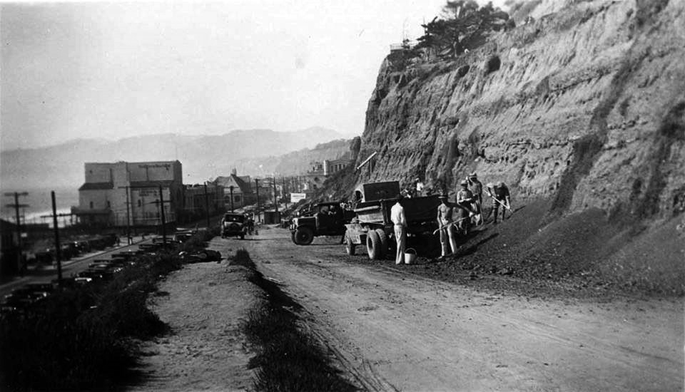
| (ca. 1929)* – View showing construction crews working on widening both Roosevelt Highway and the California Incline. |
Historical Notes The California Incline was widened and improved between 1929-1930 by the CA Division of Highways (later Cal Trans). This was about the same time the coast highway was improved and officially named the Roosevelt Highway. The coast highway was formally dedicated as the 'Theodore Roosevelt Highway' when it was completed in 1929 and was generally known as the 'Roosevelt Highway' or the 'Pacific Coast Highway'. In 1936, it was designated as US 101A (Alternate). In 1964, state legislative action changed many highway numbers in California, and US 101A became CA 1. |
 |
|
| (ca. 1929)^ – View showing construction crews working on widening the California Incline. |
California Incline: Then and Now
 |
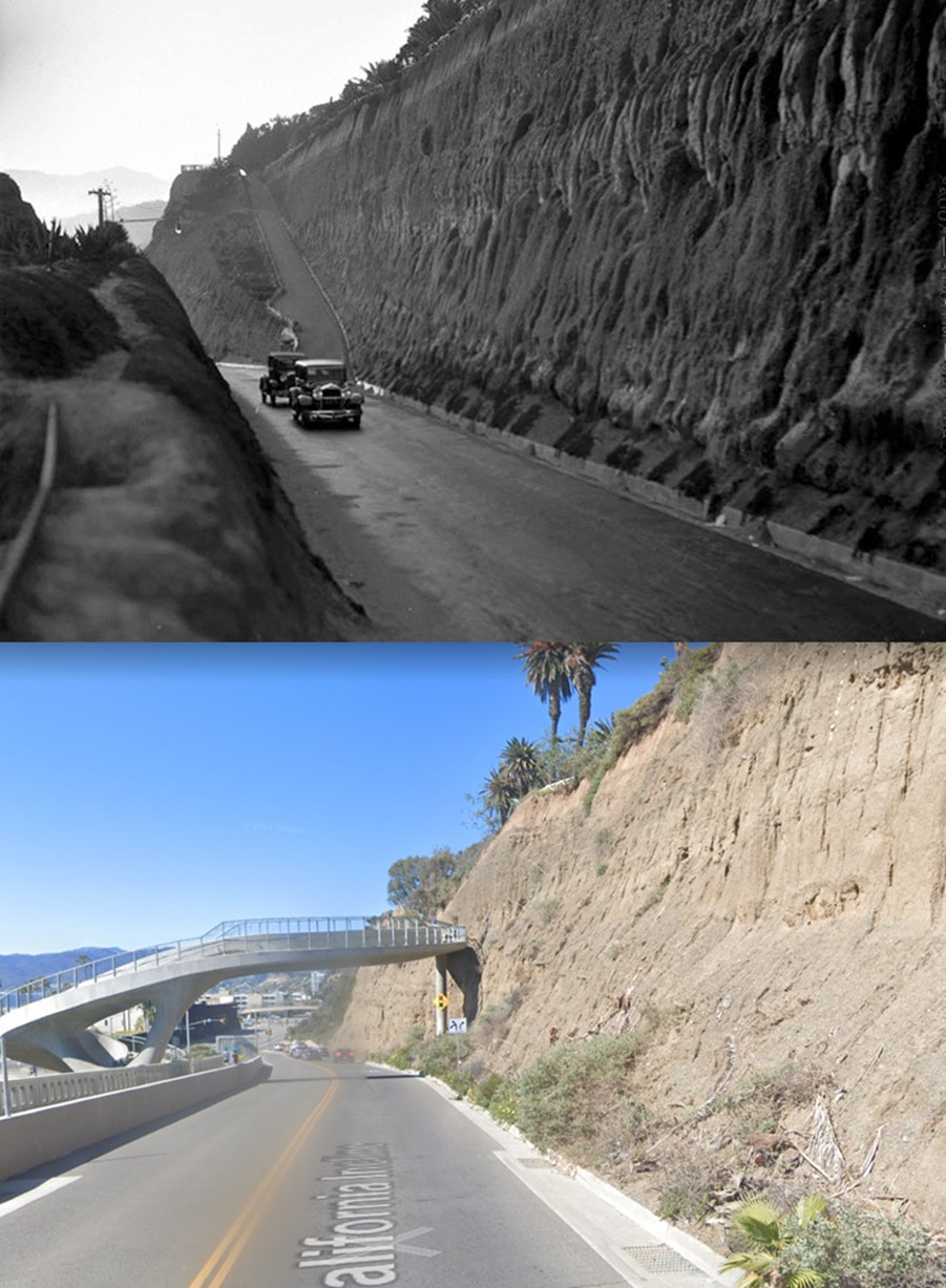
|
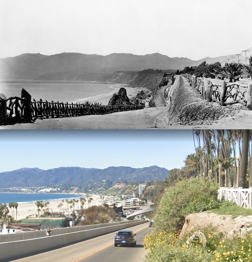
| (1905 vs. 2022)* - California Incline |
Historical Notes The California Incline was rebuilt and reopened in 2016 after being deemed "structurally insufficient" in the early 1990s. The new structure consists of a reinforced concrete slab supported by 96 concrete pilings and over 1,000 soil nails to stabilize the erosion-prone sandstone along the bluff. The expanded Incline now accommodates three lanes of traffic as well as walking and biking lanes, with two new pedestrian bridges connecting it to Palisades Park and the beach. |
Then and Now
 |
|
| (1924 vs. 2022)* - California Incline |
Historical Notes Click HERE to see more early views of the California Incline (1930 +). |
Sunset Trail
 |
|
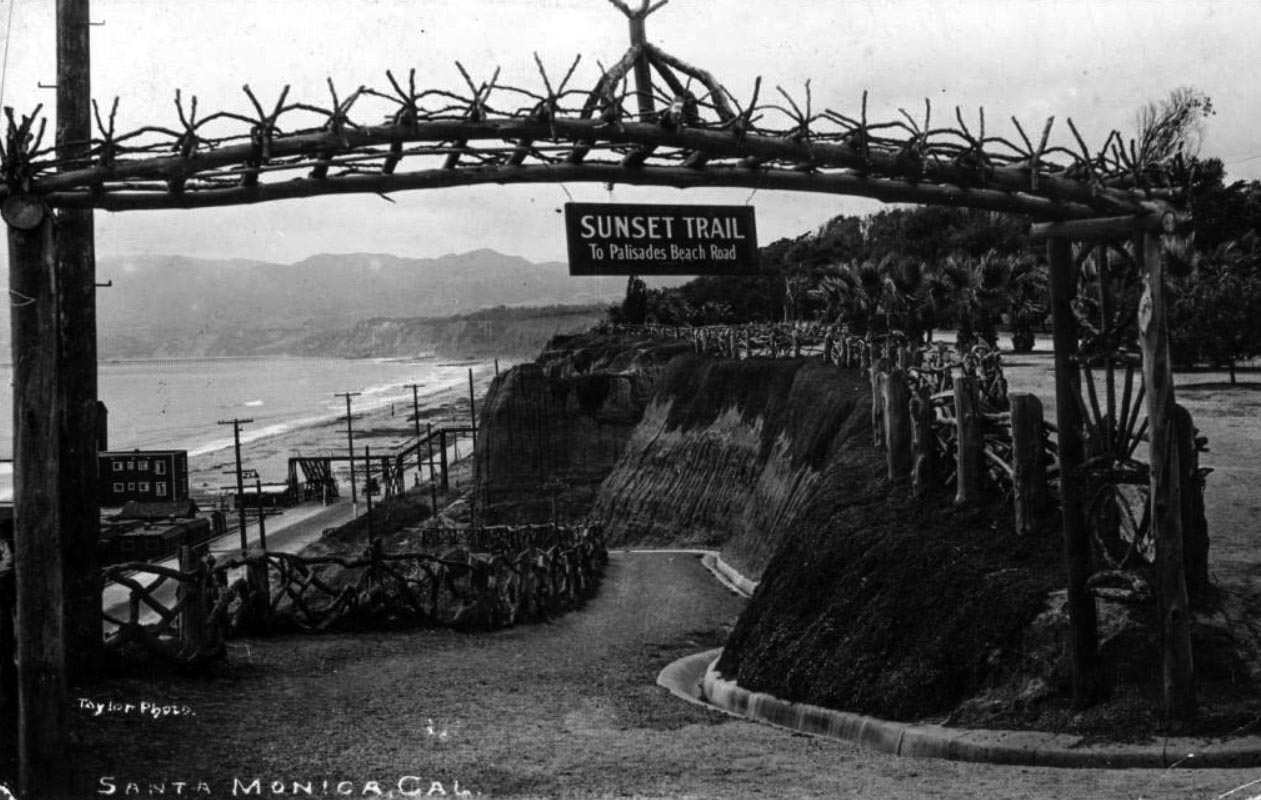
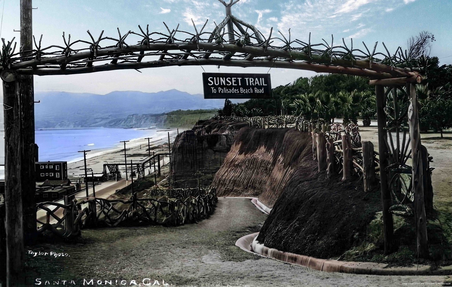
| (1910s)#^^ - View of Sunset Trail from Linda Vista Park (present day Palisades Park) to Palisades Beach Road in Santa Monica. A sign hangs from a rustic wooden archway that reads "Sunset Trail to Palisades Beach Road." The 99 Steps can be seen over the Beach Road (later part of Pacific Coast Highway) at left and the Long Wharf is visible in the distance. |
 |
|
| (1910s)^ - View of Sunset Trail from Linda Vista Park (present day Palisades Park) to Palisades Beach Road in Santa Monica. A sign hangs from a rustic wooden archway that reads "Sunset Trail to Palisades Beach Road." The 99 Steps can be seen over the Beach Road (later part of Pacific Coast Highway) at left and the Long Wharf is visible in the distance. Image enhancement and colorization by Richard Holoff. |
 |
|
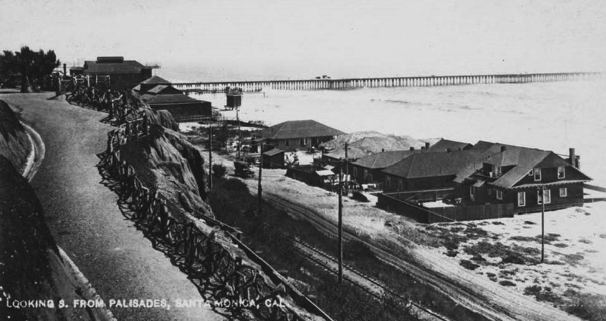
| (1910)#^^ - Postcard view of showing houses, a dirt coast road, an automobile and railroad tracks along the beach at Santa Monica, with the Santa Monica Municipal Pier (built in 1909) in the background. The Sunset Trail is seen on the left. |
 |
|
| (1914)#^^ - Image of the rustic fence from Linda Vista Park (later Palisades Park) leading down to the Beach Road (later Pacific Coast Highway) with a horse-drawn wagon parked next to houses along Sunset Beach. The Santa Monica Municipal Pier is visible in the distance. |
 |
|
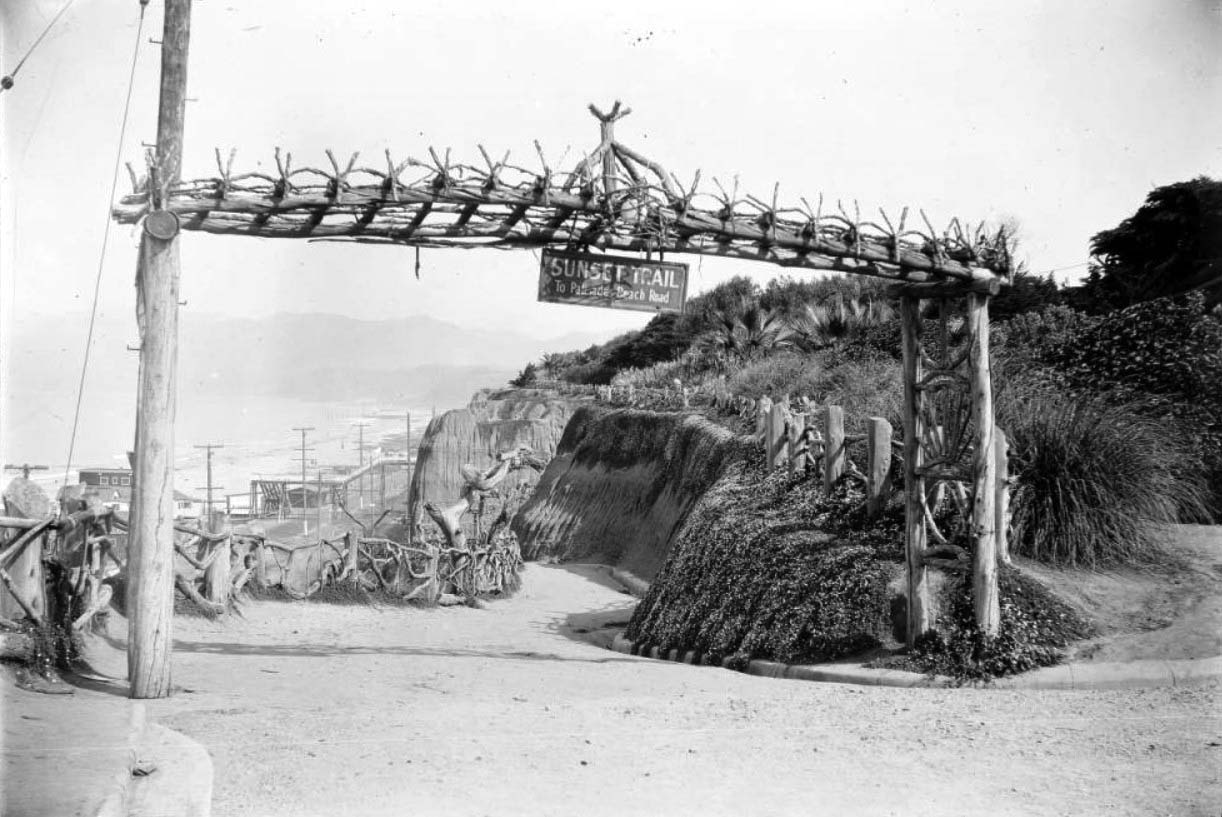
| (ca. 1920)** - Entrance to the Sunset Trail at Santa Monica's Palisades Park (originally Loma Vista Park). The trail is at center and heads down the steep face of the cliffs that give the park its name. The trail is bordered on the left side by a wooden fence made from twisted tree branches. The entrance to the trail is marked by a large wooden sign supported by a wooden framework made of tree trunks. The tops of the cliffs are at right and are covered with an assortment of bushes, and the ocean is visible in the background at left. The Pacific Coast Highway is at the base of the trail in the background at left and is lined with utility poles and beach houses. Sign reads: "SUNSET TRAIL - To Palisades Beach Road" |
Historical Notes Linda Vista Park was renamed Palisades Park in the 1920s. |
 |
|
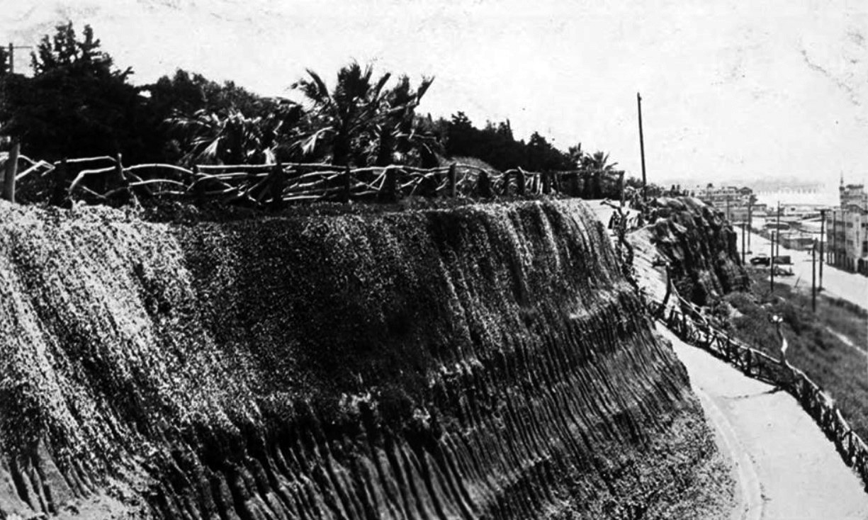
| (ca. 1920s)#^^ - View of the Palisades bluffs above the beach, with a rustic wood fence, and palm trees in Palisades Park. The Sunset Trail path is on the right; a woman is walking down it in the background. The coast road (later part of Pacific Coast Highway) and buildings on the beach are also in the view. |
 |
|
| (1950s)^x^ – Postcard view showing Sunset Trail in the early 1950s with Palisades Park (originally Linda Vista Park) seen in upper right. |
 |
|
| (2018)^^ - Sunset Trail as it appears today. |
Linda Vista Park (later Palisades Park)
 |
|
| (1900)#^ – View showing Linda Vista Park (later Palisades Park). The Santa Monica Pier can be seen in the distance. |
Historical Notes Originally known as “Linda Vista Park,” Palisades Park was the first officially-designated public open space in Santa Monica. The land was donated to the City by Santa Monica's founder, Senator John P. Jones, in 1892.*^*^ Linda Vista Park was renamed Palisades Park in the 1920s. |
 |
|
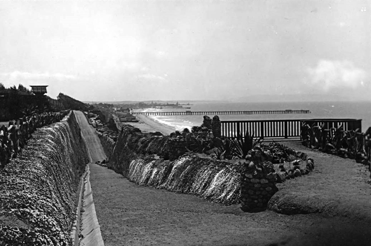
| (ca. 1909)#^ - View from Linda Vista Park (later Palisades Park) looking south toward the Santa Monica Municipal Pier. |
Historical Notes In the beginning, the parkland was scruffy. The city planted grass, Monterey cypress and eucalyptus trees (at the suggestion of Venice developer Abbot Kinney, a promoter of the Australian trees). Park development progressed under Park Commissioner Edward Sweetzer, who donated his salary to buy trees, according to a conservancy report. ^ |
 |
|
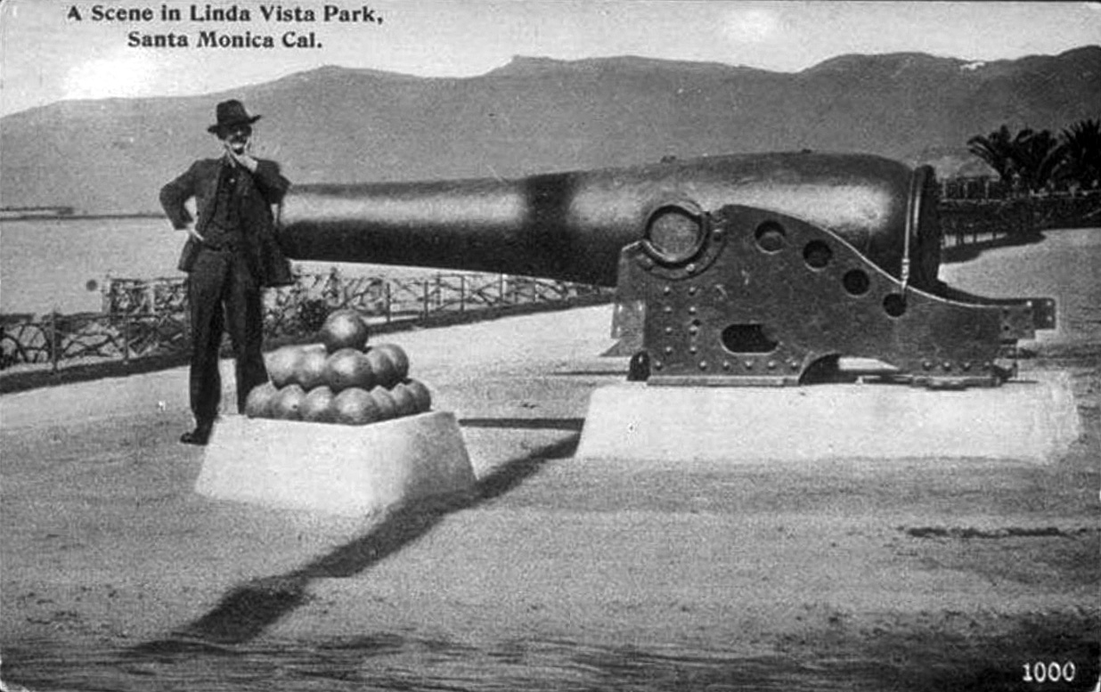
| (1908)#^ – Postcard view showing a man leaning on a cannon in "Linda Vista Park" (now Palisades Park). |
Historical Notes The cannon is an 1861 Rodman seacoast gun that was on loan from the Federal Government. It was brought to Santa Monica in 1908 from San Francisco. |
 |
|
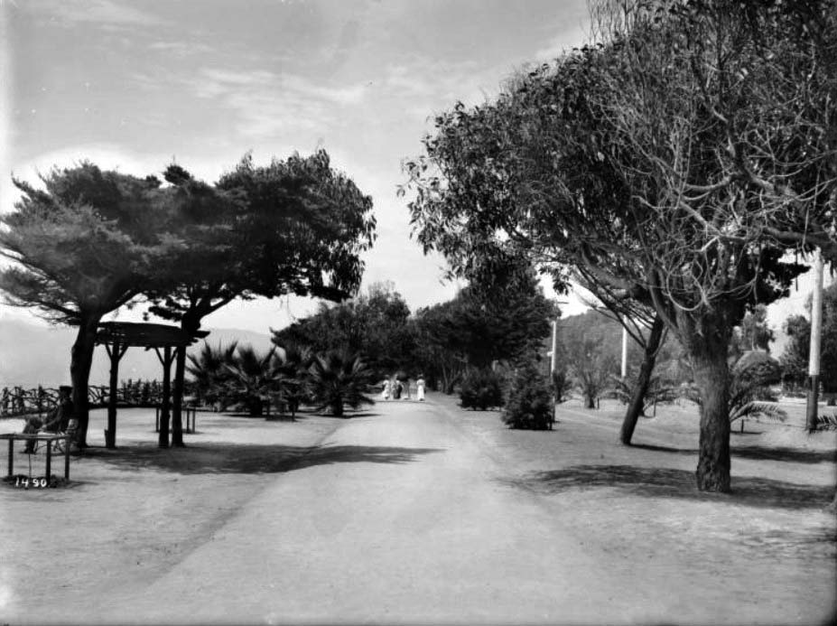
| (Early 1900s)** - View of four women strolling down the shady lane of "Lover's Walk", along the bluff in Linda Vista Park. Scattered trees line either side of the dirt walking path that runs down center. A lone man can be seen sitting on a bench under a tree looking out at the ocean at left. |
Historical Notes Inspired by the formal beaux-arts principles of the City Beautiful movement, landscape architect I.G. LeGrande in 1913 presented a park plan featuring walkways, planters, gazebos and fountains. The longitudinal pathways, colonnades of palm trees and redwood pergola date from that era. ^ |
 |
|
| (Early 1900s)^^ - View looking north from Linda Vista Park (today, Palisades Park) near the top of the California Incline. The Long Wharf can be seen in the distance. |
Historical Notes At the time it was constructed, the Long Wharf was the longest pier in the world at 4700 feet, and accommodated a train. Also known as Mammoth Wharf, it stood until 1920 when it was dismantled.*^ |
Ocean Park (Pier Avenue)
.jpg) |
|
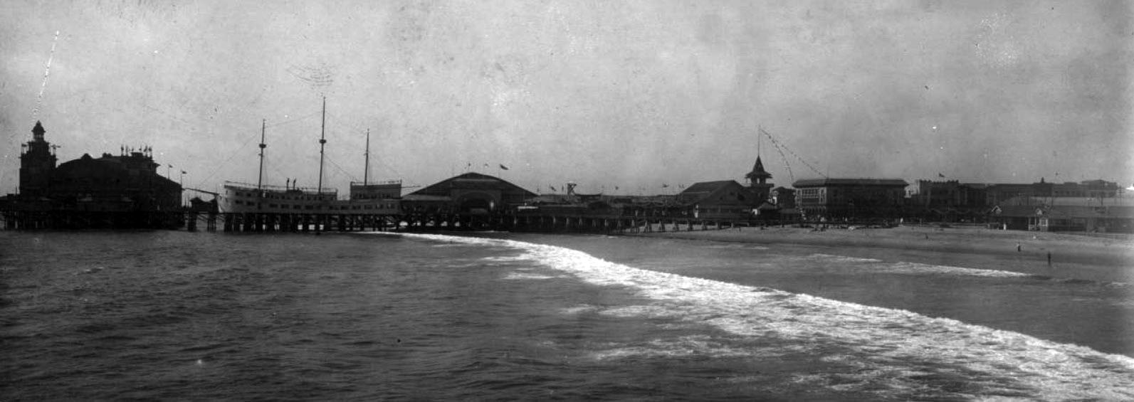
| (ca. 1900)^*## – Panoramic postcard view showing Ocean Park. The "Wave w/ Furnished Rooms" can be seen in the background. "Lunch Counter" is on the right. |
Historical Notes Although Santa Monica and Ocean Park (South Santa Monica) were both settled at the same time (in the early 1870’s), Ocean Park’s history is somewhat independent from that of the rest of Santa Monica. Separated from the north by a gully which today is occupied by the Santa Monica Freeway, Ocean Park was initially oriented towards the beach where a series of piers and other tourist attractions were erected in 1890 to 1910.^^*# |
 |
|
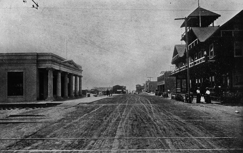
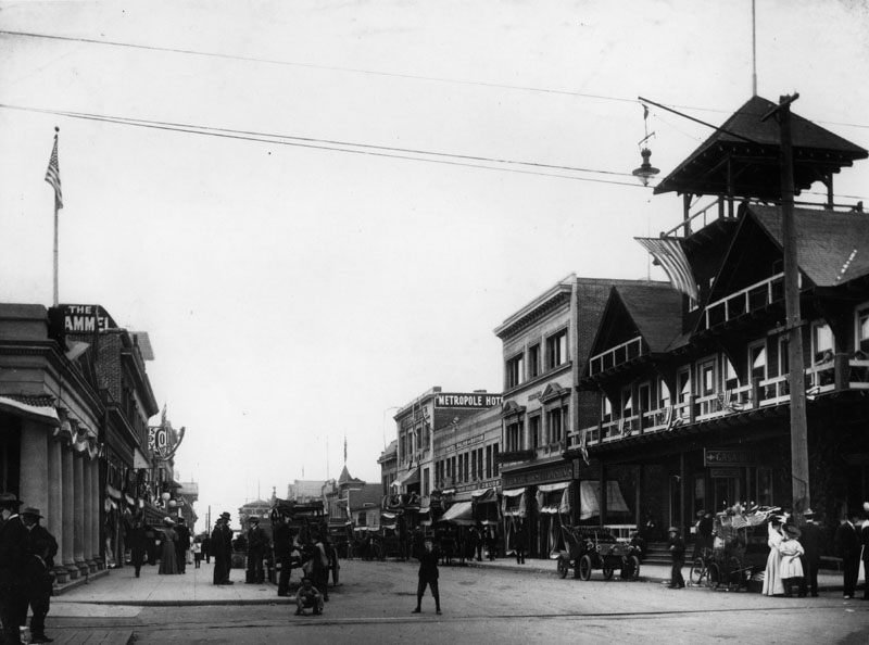
| (Early 1900s)^ - An early view down the unpaved Pier Avenue in Ocean Park. Several rail lines can be seen in the street. A bank has been built on the left and other multi-story commercial buildings on the right. The cross street is Trolley Way. |
 |
|
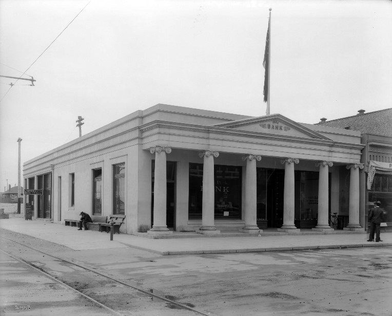
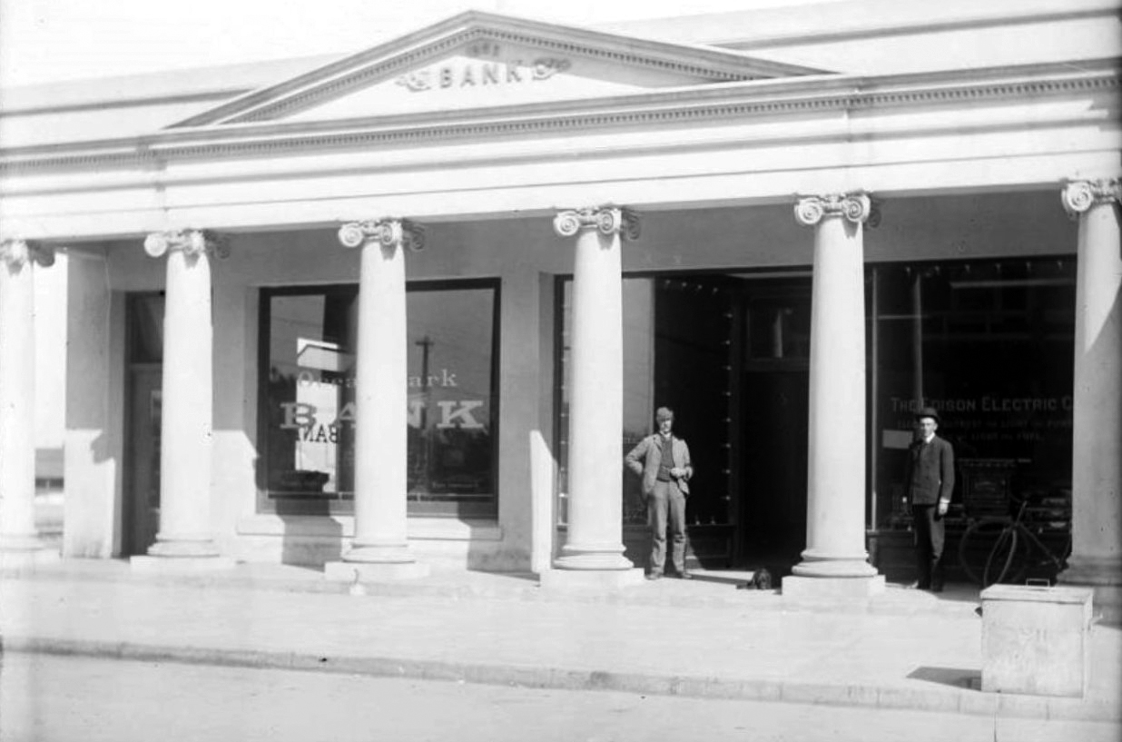
| (1905)*^ - View showing Ocean Park Bank located on the southwest corner Pier Avenue and Trolley Way. A man is sitting on a bench on the side of the bank in front of the tracks. The bank resembles a Greek Temple with its columns. |
 |
|
| (Early 1900s)**^ - View showing two men standing in front of the Ocean Park Bank on Pier Avenue. The Edison Electric Co. shared the building with Ocean Park Bank. |
 |
|
| (1905)* - A view down Pier Avenue showing additonal buildings from what was seen three photos back. The street is filled with pedestrians. Cars and horse-drawn carriages are parked in front of the stores on both sides of the street. |
Historical Notes One of the city’s oldest neighborhoods, Ocean Park sprang to life with Abott Kinney’s 1891 Ocean Park Development Company. Kinney bought a sandy strip of land in Santa Monica’s southwestern edge and began building roads, homes, parks and piers. After 1904, Kinney moved his attention to his Venice of America development (also called Ocean Park at the time), south of the Santa Monica city boundary. The history of Venice and Ocean Park are intertwined.^^*# |
 |
|
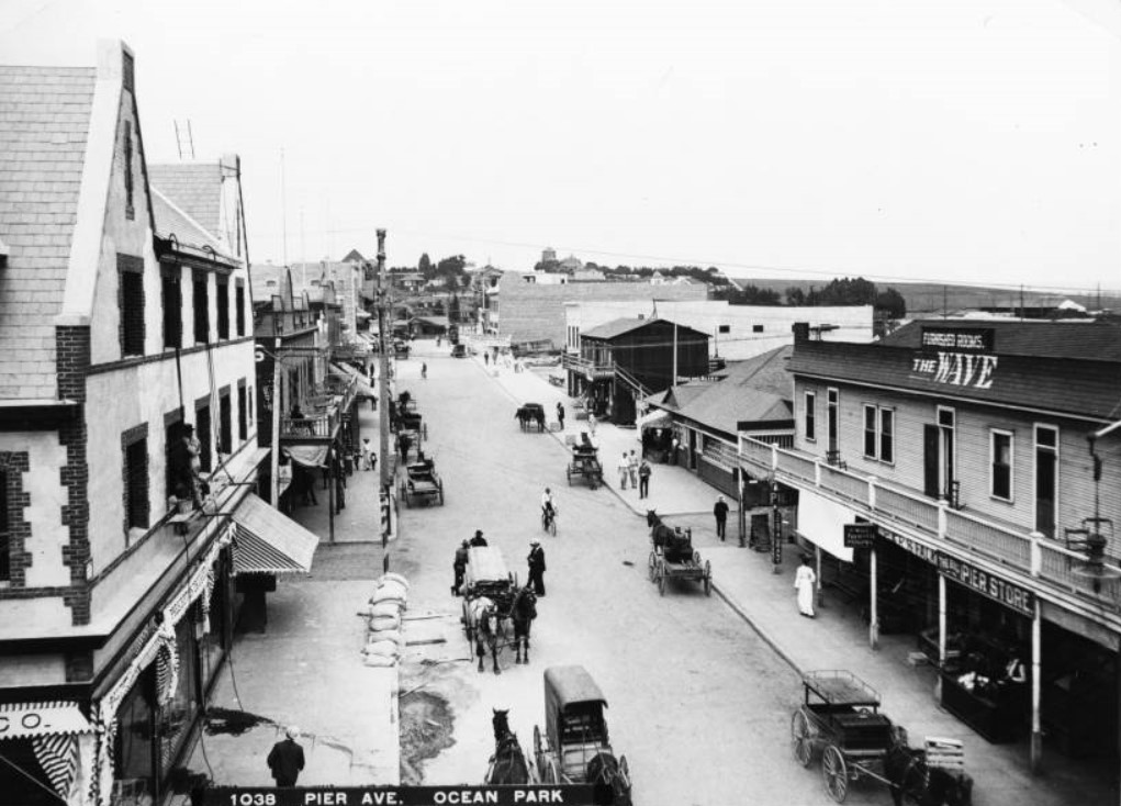
| (1904)** – Birdseye view of Pier Avenue in Ocean Park showing many horse-drawn vehicles, September, 1904. The unpaved street is at center is being traveled by several carriages as well as pedestrians and bicyclists. Large buildings, most of which are at least two stories high, line both sides of the street. A wooden building at right has a large balcony, while a brick building at left has three stories. Sand bags are piled up near the street at left.; Legible signs include, from left to right, "Pier Restaurant", "Wave Furnished Rooms", and "The Big Pier Store". |
Historical Notes The southern part of Santa Monica, commonly known as “Ocean Park,” was already an important business center as well as a popular summer resort. With the completion of the bath house and the Decatur Hotel, the building of the Masonic block and many other business blocks on Pier Avenue, Marine street and the ocean front began to put on a metropolitan aspect.^^*# |
 |
|
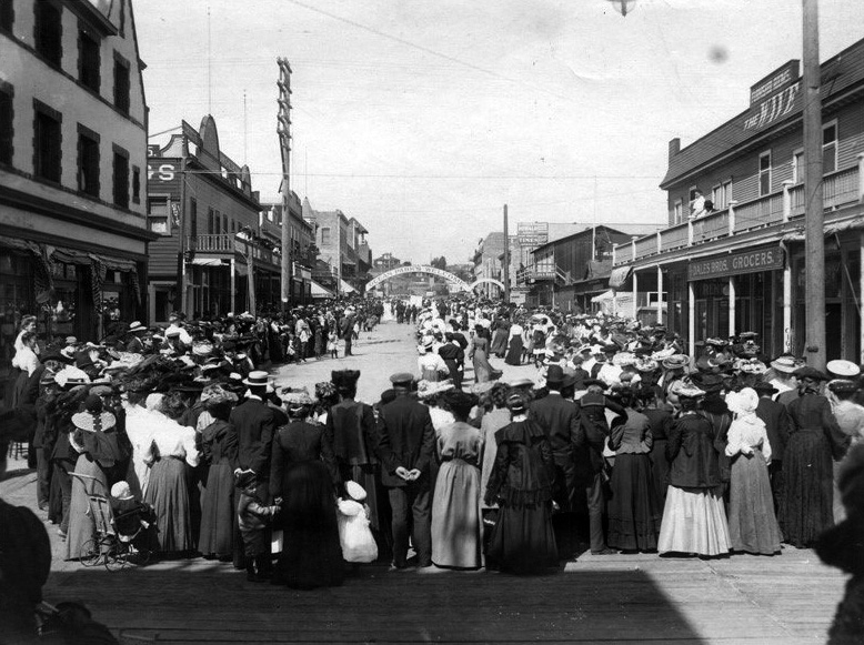
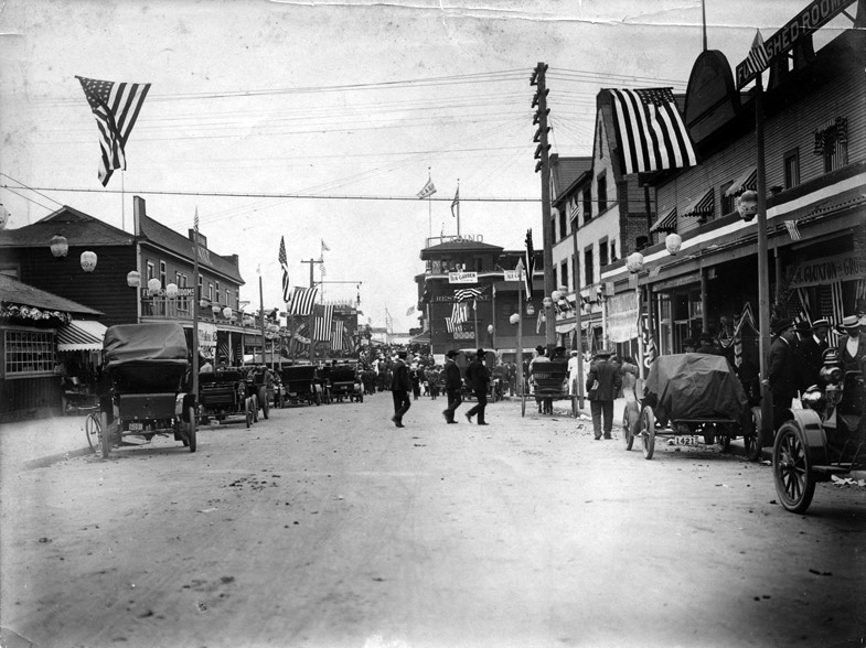
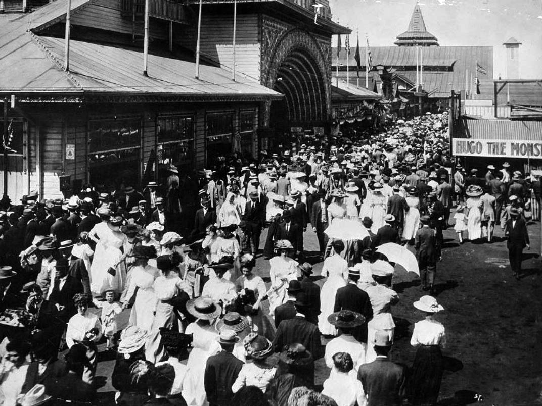
| (ca. 1905)^^^ – View showing Pier Avenue with a crowd of men, women and children (including baby in a baby carriage waiting for some type of parade. The banner over the street reads “Ocean Park’s Welcome”. Buildings include: Dales Bros. Grocers, The Wave (furnished rooms), lunch room. |
.jpg) |
|
| (1915)^.^ - Looking east on Pier Avenue, Ocean Park, Santa Monica. The Wave is on the right. |
.jpg) |
|
| (1915)#*#* – Closer view of Pier Avenue, looking east, showing a line of cars backed up against the curb. Note the new 3-bulb streetlamps. |
 |
|
| (ca. 1905)^^^ – View looking down Pier Avenue in Ocean Park. Horse-drawn carriages, early model cars, and people share the street with American flags and banners seen throughout. The Wave w/Furnished Rooms is on the left. |
 |
|
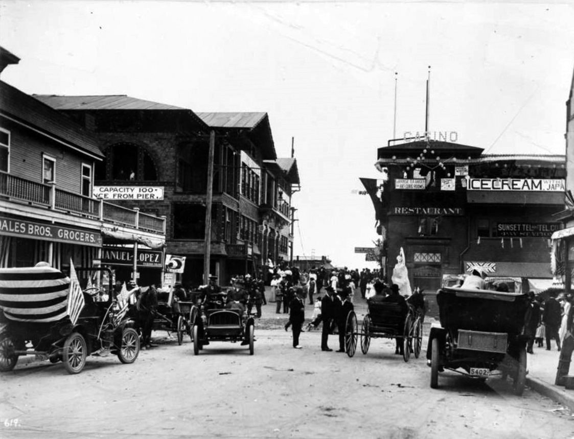
| (1905)#^^ - View showing businesses, automobiles, and horse-drawn carriages on Third Street and Pier Avenue at Ocean Park in Santa Monica. Visible signs include "Ocean Park Improvement Company Headquarters Beach Lots" "Casino" "Japanese Tea Garden and Art Curio Rooms, " "Sunset Tel. and Tel. Co. Pay Station" "Manuel-Lopez Habana Cigar" and "Dales Bros. Grocers." There is a statue of a woman at center right. |
 |
|
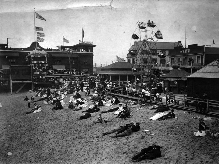
| (ca. 1905)^^^ - View showing Casino Restaurant, theatre, beach crowded with sunbathers, ferris wheel and Pier Avenue in the background. The "Wave w/Furnished Rooms" is on the right. |
.jpg) |
|
| (ca. 1905)^^^ – View the Casino restaurant and bandstand at Ocean Park in Santa Monica. Crowds of people watch a performance taking place on the bandstand which is decorated with flags and bunting. A wharf extends behind the theatre. |
 |
|
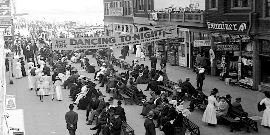
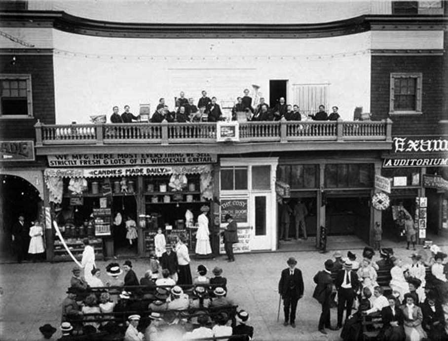
| (ca. 1907)##*^ - View of the Ocean Park Promenade in Santa Monica showing how people went for a walk at the beach – fully dressed with hats, collars, ties, and floor-length dresses. The balcony at top right is where a band would play for the people down below. |
 |
|
| (1909)#^ – View showing Frank McGarry's candy store and Band Plaza, located in Ocean Park between Pier Avenue and Marine Streets. Frank Gregory was the Band Director of the Lincoln Park Band. |
Click HERE to see more Early Views of Ocean Park in Santa Monica |
* * * * * |
Venice Pier
 |
|
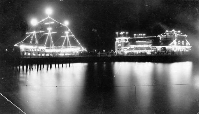
| (ca. 1905)** - Panoramic view looking north at the Pier at Venice Beach showing the amusement park and beach. The Ship Cafe is seen on the left. |
Historical Notes Among the South Bay piers, the most notable in this period was Abbot Kinney's Venice of America pier, started in 1904 and built to rival his former partner's Ocean Park Pier. Located at the end of Windward Avenue in Venice, Kinney's pier was 900 feet long, 30 feet wide and included an Auditorium, large replica Ship Cafe, Dance Hall, Dentzel carousel, a Japanese Tea House and an Ocean Inn Restaurant. Venice soon became considered its own neighborhood.*^ |
 |
|
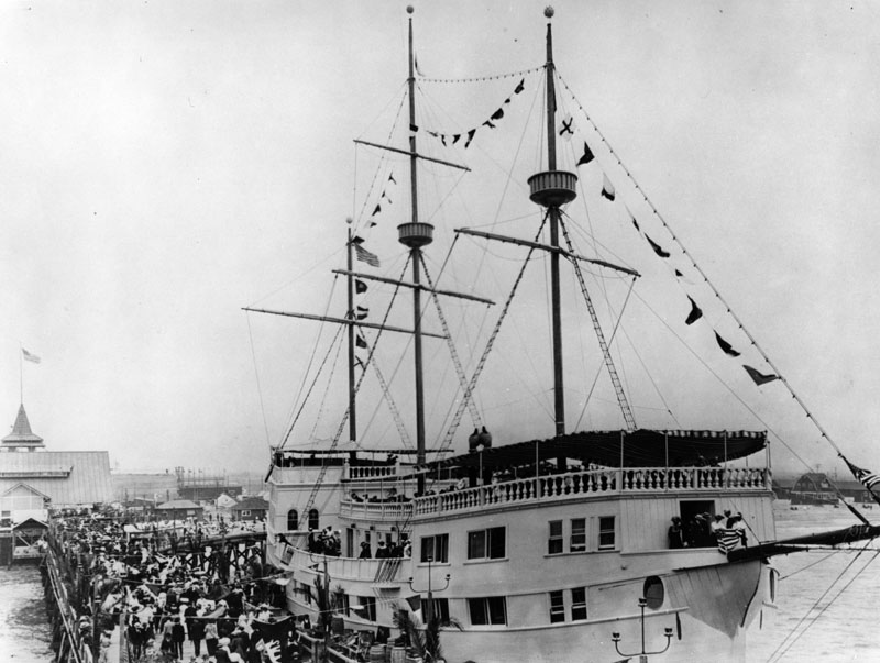
| (1905)* - A big crowd is seen behind the large restaurant ship which was a replica of Juan Cabrillo's Spanish galleon. People can also be seen aboard the ship which was located in Venice at the Abbot Kinney Pier. |
Historical Notes Venice of America was founded by tobacco millionaire Abbot Kinney in 1905 as a beach resort town. He and his partner Francis Ryan had bought two miles of oceanfront property south of Santa Monica in 1891. They built a resort town on the north end of the property called Ocean Park, which was soon annexed to Santa Monica. After Ryan died, Kinney and his new partners continued building south of Navy Street in the unincorporated territory. After the partnership dissolved in 1904, Kinney built on the marshy land on the south end of the property, intending to create a seaside resort like its namesake in Italy.*^ |
 |
|
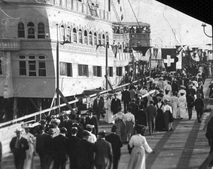
| (1906)** – Closer view showing a large number of well-dressed people walking on Abbot Kinney’s Venice of America pier alongside the Ship Café. Handwritten note on verso reads: "Ship Cafe / Venice, Cal. / 12-16-06" |
 |
|
| (1905)* - Nigthtime view of Abbott Kinney's Pier in Venice. The pier was destroyed by fire in 1920. |
Historical Notes When Venice of America opened on July 4, 1905, Kinney had dug several miles of canals to drain the marshes for his residential area, built a 1,200-foot long pleasure pier with an auditorium, ship restaurant, and dance hall, constructed a hot salt-water plunge, and built a block-long arcaded business street with Venetian architecture. Tourists, mostly arriving on the "Red Cars" of the Pacific Electric Railway from Los Angeles and Santa Monica, then rode Venice's miniature railroad and gondolas to tour the town.*^ |
 |
|
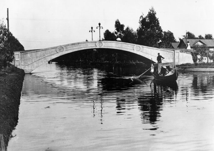
| (ca. 1905)*^ - A gondolier and boat passes under one of the bridges on the canal route. At the same time a pedestrian and a bicycle rider are passing over the bridge. |
Historical Notes The beautifully lit canals with gondoliers and arched bridges drew widespread publicity and helped sell lots in Kinney’s Venice development. However, as the automobile gained in popularity, the canals were viewed by many as outdated, and the bulk of the canals were filled in 1929 to create roads.*^ Click HERE to see more Early Views of the Venice Canals (1904+). |
 |
|
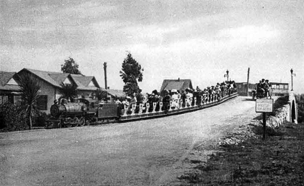
| (ca. 1905)*#** - View of the Venice Miniature Railway train crossing over a Venice Canal bridge on its way back to Windward Avenue at the Venice of America Amusement Park. |
Historical Notes When Abbot Kinney was building Venice in 1905, he decided that his new resort should have an internal transportation system to shuttle visitors and residents around town. He turned to John J. Coit who operated a successful eighteen inch gauge (1/3rd scale) miniature steam railroad at Eastlake Park (now Lincoln Park) in Los Angeles. He persuaded him to oversee the construction and management of a mile and three quarter long railroad that would take passengers from the Windward Avenue business district on a loop across canal bridges and through the canalled residential district, then return via a loop up Washington Boulevard, past its Lake Avenue maintenance yard and back to the Windward station along Mildred Avenue.*#*#* |
 |
|
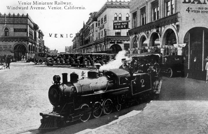
| (1912)* - Postcard view of the Miniature Railway on Windward Avenue in Venice. The miniature railroad would carry passengers for trips around the Venice streets, including Windward Ave. as shown here, and around the canal area. |
Historical Notes The cost of a trip around Venice was five cents, although residents could buy a book of tickets for $1.00 which made the run only two cents. At that time, it cost 15 cents to ride from Los Angeles to Venice on the Los Angeles Pacific Railway. *#** |
 |
|
| (ca. 1905)** - Several people stroll by the Dance Hall on the Amusement Pier at Venice Beach circa 1905. "Dance Hall / Venice" -- handwritten note on verso. |
 |
|
| (1908)** - Venice Pier on a crowded day with the Dance Hall seen in the background. |
 |
|
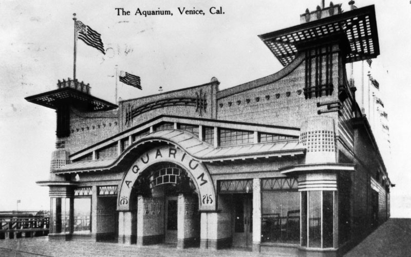
| (ca. 1908)* - A view of the front of the Aquarium, with flags flying all around the top of the building. |
Historical Notes The Venice Beach Aquarium exhibited the finest collection of marine specimens on the Pacific coast. It later became the official marine biological station for the University of Southern California.* |
Click HERE to see more in Early Southern California Amusement Parks. |
North Beach
 |
|
| (ca. 1900)** - View of a crowded North Beach in Santa Monica with the pier in the background. The boardwalk is also full of people enjoying what appears to be a nice day at the beach. |
 |
|
| (ca. 1900)* - Photo of men wearing suits and finely dressed women, sitting on the sand, standing and walking the boardwalk at North Beach in Santa Monica. The North Beach Bathhouse pier can be seen in the background. |
 |
|
| (Early 1900s)* - Group portrait of eight people, finely dressed, standing on the beach. The pier can be seen in the background. |
 |
|
| (ca. 1900)** - View of eleven young men and women knee-deep in the ocean posing for the photographer. |
North Beach Bath House
.jpg) |
|
| (1905)* - Crowds of people wearing their fine dress are seen strolling along the boardwalk and sitting on the beach, in front of the North Beach Bath House in Santa Monica. |
Historical Notes The North Beach Bath House replaced the original Santa Monica Bath House in 1894. It was for many years the area’s favorite resort facility. A special feature was the hot saltwater baths. The admission fee was twenty-five cents. The building also housed a restaurant, a bowling pavilion and the first Camera Obscura. At the turn of the century, thousands of people were coming to visit the Santa Monica beach and its attractions.^#* |
 |
|
| (ca. 1900)^#* - Interior view of the North Beach Bath House. |
 |
|
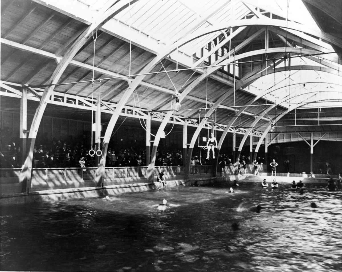
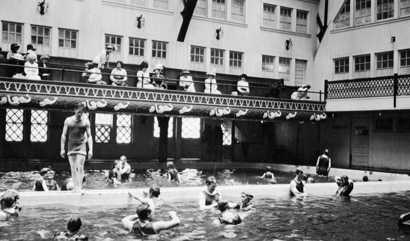
| (ca. 1900)* - View of the indoor plunge in Santa Monica-Ocean park. Several people are swimming while spectators (in street clothes) watch from the bleachers along the side. |
Santa Monica Municipal Pier (West Coast's 1st Concrete Pier)
 |
|
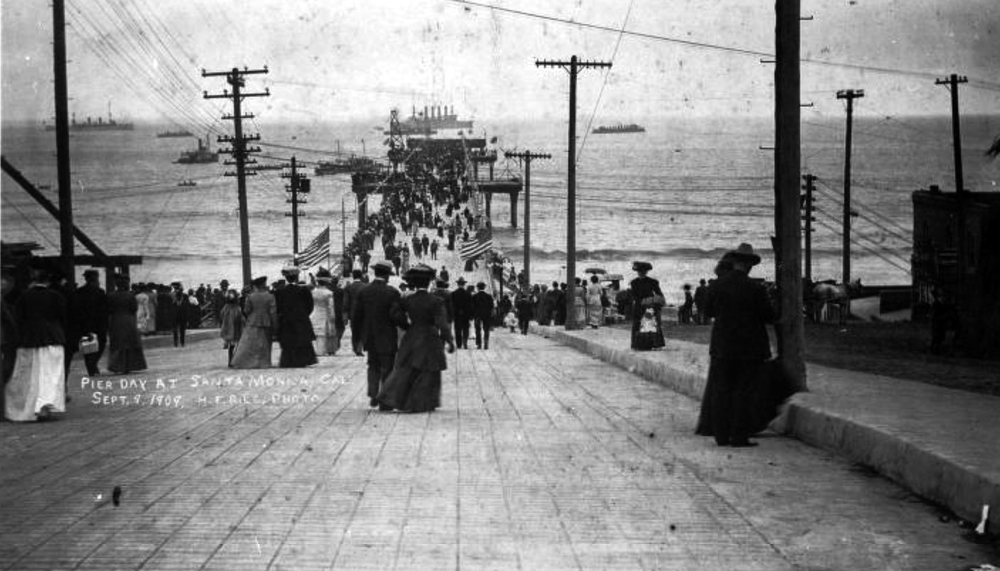
| (1909)#^^ - View showing people walking onto the Santa Monica Municipal Pier on Pier Day, September 9, 1909, in Santa Monica. In the distance United States Naval vessels are seen anchored offshore for the event. |
Historical Notes On September 9, 1909, after sixteen months of construction, the Santa Monica Municipal Pier opened to the public. Thousands of people swarmed onto the 1,600-foot-long concrete pier to enjoy a festive day of band concerts, swimming races and the novelty of walking above the waters of the Pacific Ocean. While originally built to satisfy the City's sanitation needs, the Pier quickly became a magnet for the fishing community and fueled the imagination of many local entrepreneurs.^ |
 |
|
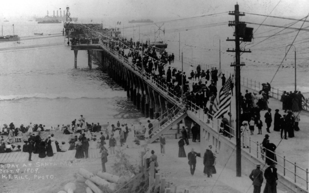
| (1909)^.^ – View showing the Santa Monica Municipal Pier on opening day, September 9, 1909. Photo Credit: Santa Monica Pier Restoration Corporation |
Historical Notes The growth of Santa Monica in the early twentieth century forced the city to confront a very serious sewage disposal problem. After considering several options, officials agreed that the best method was to build a pier and cast it out to sea. L.G. Osgood of the California Ornamental Brick Company recommended using concrete to construct the pier. Wooden piers were notorious victims both of the weather and of infestation by wood-burrowing clams called shipworms or Teredo Worms. The City Council concurred, and committed to the first concrete pier on the West Coast. On September 28, 1907, the public voted in favor of a $150,000 bond to build the proposed pier. Of eleven plans submitted for the new pier, the City Council chose local architect Edwin H. Warner’s design, which proposed a 1,600-foot-long pier supporting an eighteen-inch outfall pipe running underneath the entire length of the pier’s floor, inclined so that gravity would carry the treated waste to the ocean. The plan included a treatment plant on the beach at the foot of the pier, designed to purify the sewage and pump it into the outfall pipe for disposal. The construction contract was awarded to the Stutzer Cement and Grading Company and on April 8, 1908, work on the new pier began. Journalists arrived from across the country to observe the construction of the West Coast’s unique new concrete pier, and in turn became well acquainted with the charming seaside community where it stood. On August 18, 1909 the new pier was completed with only a few minor finishing details remaining, and Mayor T.H. Dudley declared September 9 the official opening day of the new Santa Monica Municipal Pier. Thousands of people attended the grand opening and dedication ceremony, a full day of festivities and activities commemorating the City’s magnum opus—the West Coast’s first concrete pier. The celebration commenced with a parade that began at Santa Monica City Hall and ended at the foot of the new pier, where Mayor Dudley dedicated it and the featured speaker, State Senator Lee C. Gates commended the citizens of Santa Monica for their energy, spirit and courage for using groundbreaking technology. Santa Monica, he declared, had set the precedent for all future piers.* Excerpt from Santa Monica Pier: A Century on the Last Great Pleasure Pier by James Harris (Angel City Press, 2009) |
 |
|
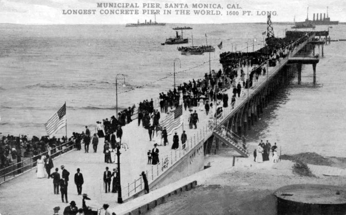
| (1909)^x^ – Postcard view showing the newly constructed Santa Monica Municipal Pier on opening day. Heading reads: Municipal Pier, Santa Monica. Longest Concrete Pier in the World, 1600 Ft. Long. |
Historical Notes The above postcard was produced to advertise the Balloon Route Excursion, a daily trolley car site-seeing route that operated under the management of C. M. Pierce (and the Los Angeles Pacific Co.) between 1904 and 1911. Printed on front: Longest concrete pier in the world, 1600 ft. long. On reverse: Balloon Route Excursion, The Scenic Trolley Trip. Paralleling the mountains from Los Angeles to the ocean, then 36 miles along the Seashore. Parlor Cars; Reserved Seats; Competent Guides. Free Attractions - An ocean voyage on wheels, the cars running a mile into the ocean on Long Wharf, Port Los Angeles; Admission to Largest Aquarium on Pacific Coast; Ride on the L.A. Thompson Scenic Railway at Venice; Admission to Camera Obscura, Santa Monica. Last car 9:40 A.M. Daily, 429 South Hill, Los Angeles. |
 |
|
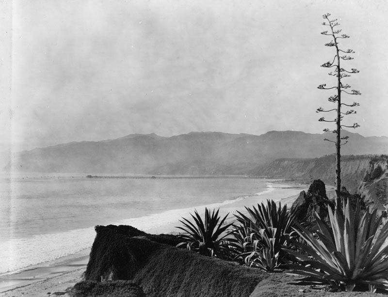
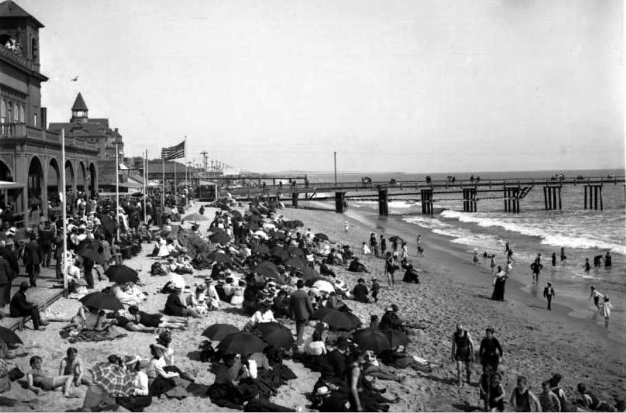
| (ca. 1909)** - View Santa Monica Beach looking south from the Palisades. The beach is at right, and running next to it is a two-lane paved highway. Making its way parallel to the road is a railroad. There are tall cliffs at left, covered in a variety of plants and trees. A small group of buildings is visible at center near the water, and a long pier (Santa Monica Municipal Pier) juts out into the ocean from near these buildings. There is a shorter pier in the foreground, and two people can be seen walking along the sand at right. |
 |
|
| (ca. 1910)* – Closer view showing railroad tracks running parallel to an old dirt road along the Santa Monica beach front. This site is now the Roosevelt Highway. In the background can be seen Santa Monica Municipal Pier. |
Historical Notes In 1917 Charles Looff, a famous carousel carver turned amusement entrepreneur, built a wider pier with an amusement park along the south side of Municipal Pier. Both piers combined were referred to as Santa Monica Pier. Click HERE to see Early Views of the Santa Monica Pier (1917+). |
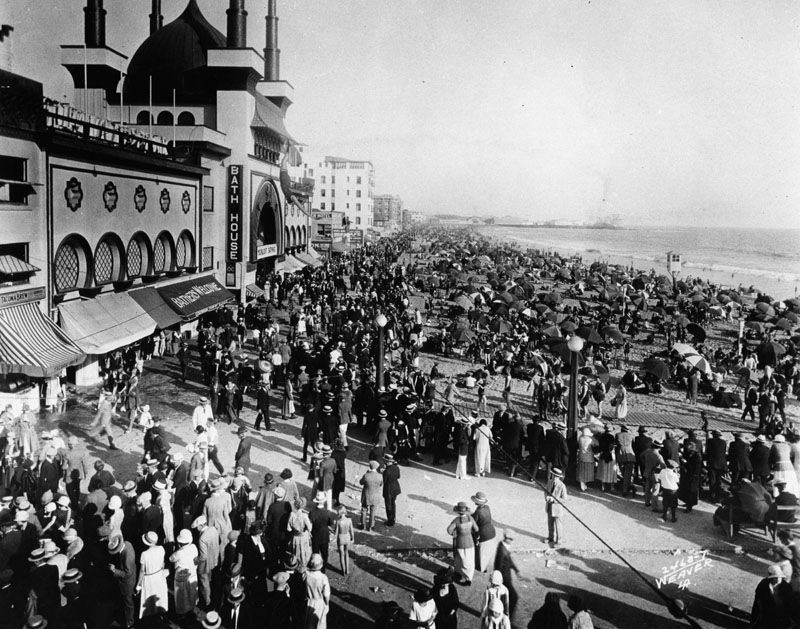
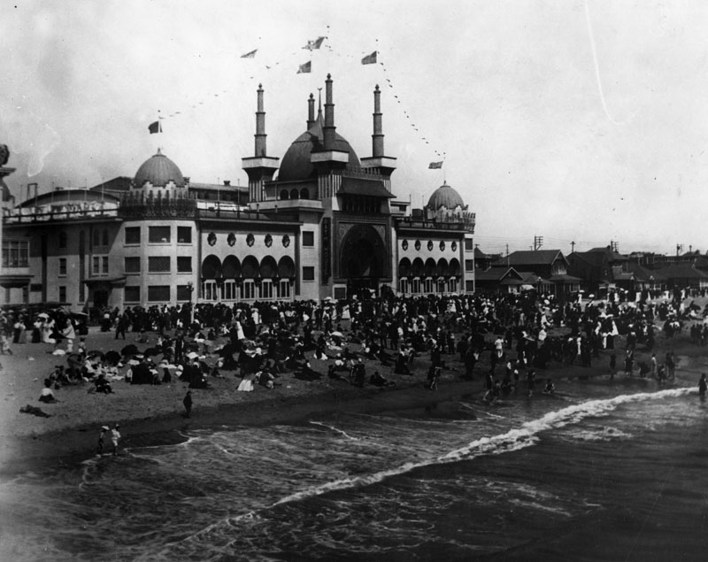
Ocean Park Bath House
 |
|
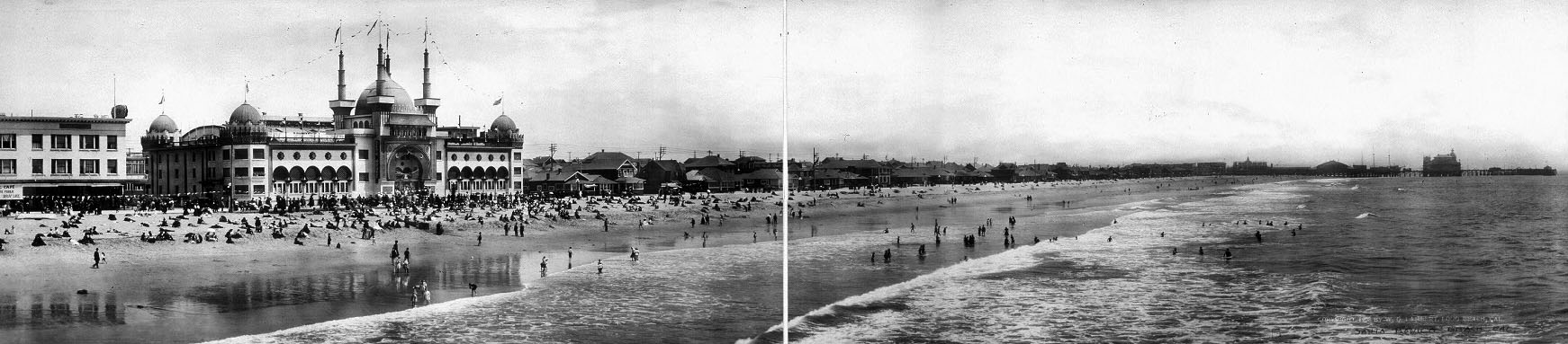
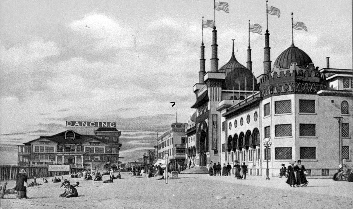
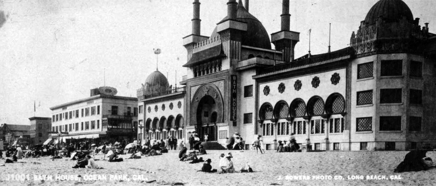
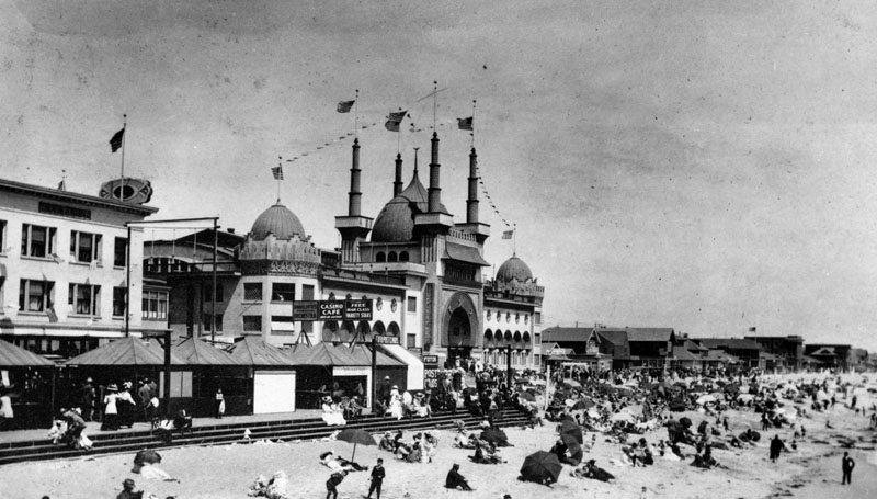
| (ca. 1908)## – Panoramic view looking south from Ocean Park Pier in Santa Monica. The beautiful Ocean Park Bath House, built in 1905, is seen on the left. |
Historical Notes When it was built in 1905, the Ocean Park Bath House was one of the most elaborate structures on Santa Monica's beach. It was Moorish in style, 3 stories high with 5 domes. An ad from 1906 claimed it had the largest swimming pool in the US.*^*^ |
 |
|
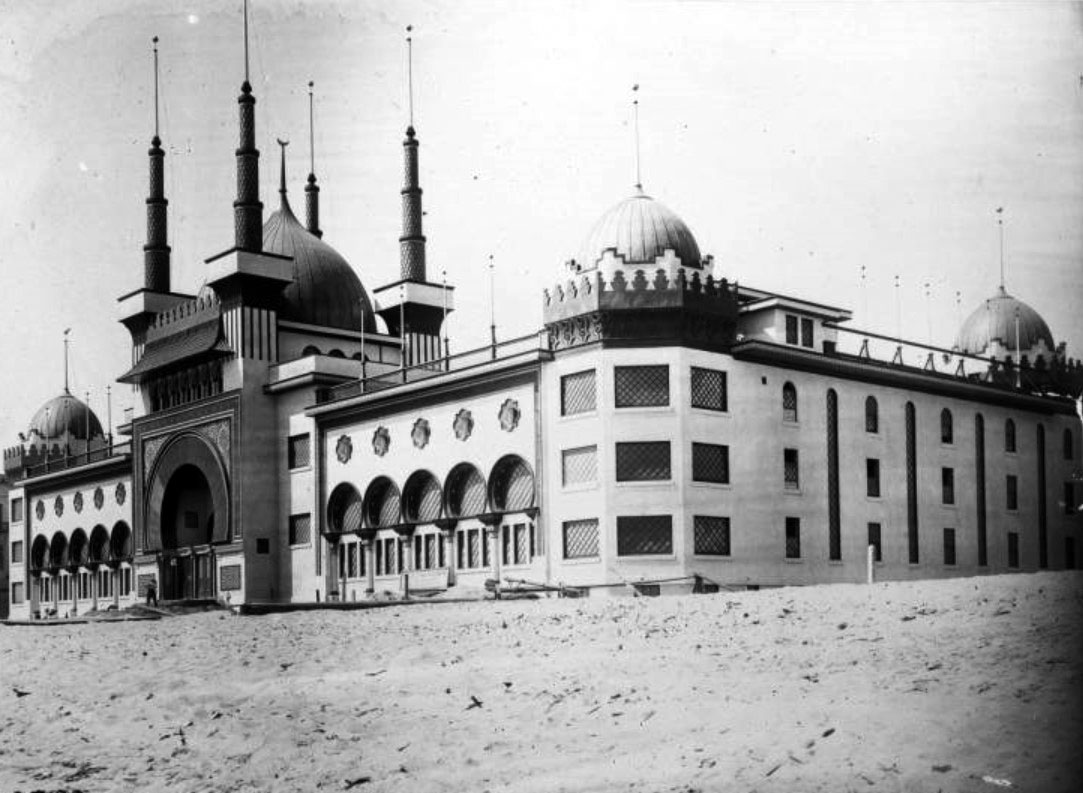
| (1905)** - View of Moorish style Ocean Park Bath House, nearing completion. Round turrets rise from each of the corners as well as over the main entrance. Rows of arched or round windows line the exterior of the three-story building on the beach. Laborers are seen working near the entry. |
Historical Notes Looking more like a movie set, the Ocean Park Bath House was one of the most talked about buildings of its day-and a great draw for the beach area. The lavish indoor plunge (heated for those who didn’t take to cooler ocean swimming) was built by A.R. Fraser. ^^*# |
 |
|
| (ca. 1909)*- Postcard view of Ocean Park beach with pier in the distance and Ocean Park Bath House on the right. |
 |
|
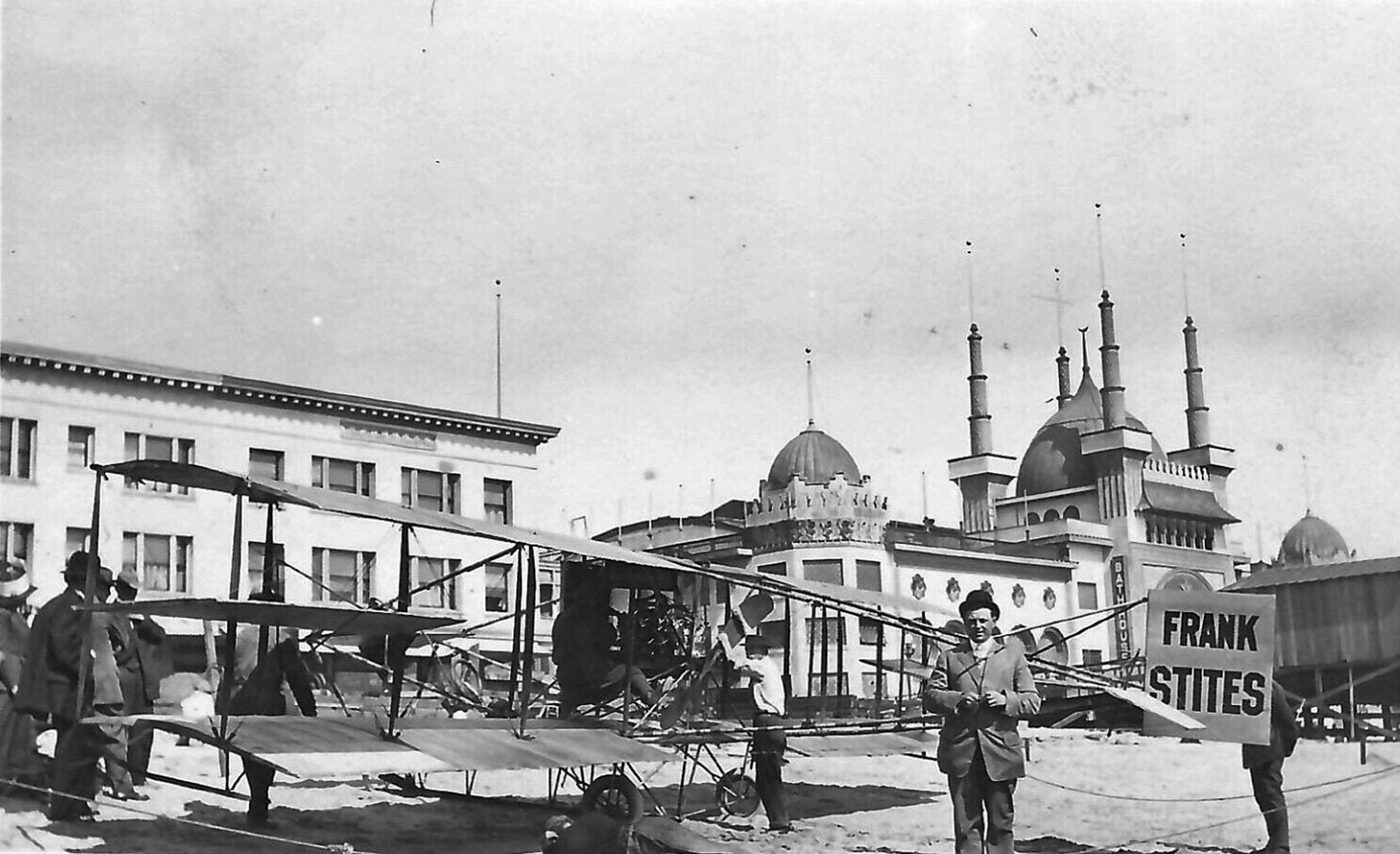
| (ca. 1909)* - Frank Stites airplane on the beach in front of Ocean Park Bath House. |
Historical Notes Daredevil pilots landed on the beach since there was no airport back then. The Kinney Company hired many. |
 |
|
| (ca. 1910)#^^ – Panoramic view showing people on the beach in front of the Ocean Park Bath House at Ocean Park, in Santa Monica. |
 |
|
| (Early 1900s)* - Crowded shoreline in front of the Ocean Park Bathhouse at Ocean Park Beach. |
Historical Notes In 1903 Alexander Rosborough Fraser built the Ocean Park Casino, and in 1905 erected the Ocean Park Bath House. In 1906 he built the Ocean Park Auditorium, the Masonic Temple and the Decatur Hotel. In 1911 “Fraser’s Million Dollar Pier,” was completed, extending 1000 feet over the ocean and housing a multitude of amusements, including a beautiful dancing pavilion. Fraser built numerous improvements in Ocean Park, and is responsible for the construction of the concrete promenade which joins Ocean Park with Venice. #^* |
 |
|
| (Early 1900s)* - Heavy crowd day on the beach and in front of the Ocean Park Bath House. |
 |
|
| (Early 1900s)* - Crowded beach at Ocean Park in front of the Bath House. |
 |
|
| (ca. 1910)* – Closer view showing railroad tracks running parallel to an old dirt road along the Santa Monica beach front. This site is now the Roosevelt Highway. In the background can be seen Santa Monica Municipal Pier. |
 |
|
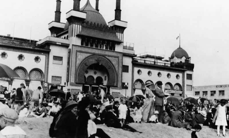
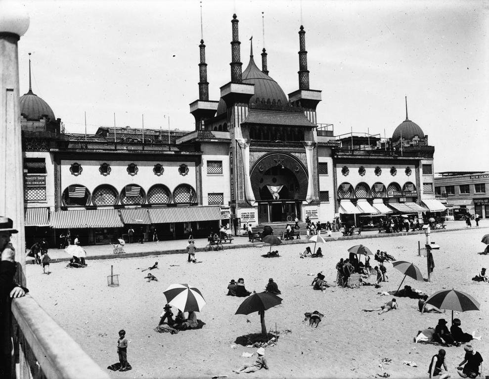
| (ca. 1920)** - Exterior view of the Ocean Park Bath House in Santa Monica from the pier. The bath house is at center and is a large Moorish-style building. At the center of the building is an elaborate entry way consisting of a large domed tower surrounded by four tall spires. Smaller domed towers occupy the corners of the buildings. Awnings project from the bottom story of the building, and rows of round windows occupy the second and third stories. |
 |
|
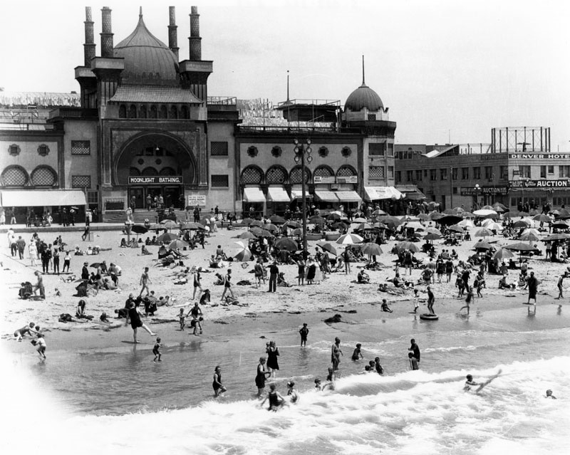
| (1921)*^ - A view of the beach and ocean water with the Ocean Park Bath House in the background, offering (sign over the door) moonlight bathing. To the right is a building Denver Hotel with a sign below it announcing Yosemite Auction. |
 |
|
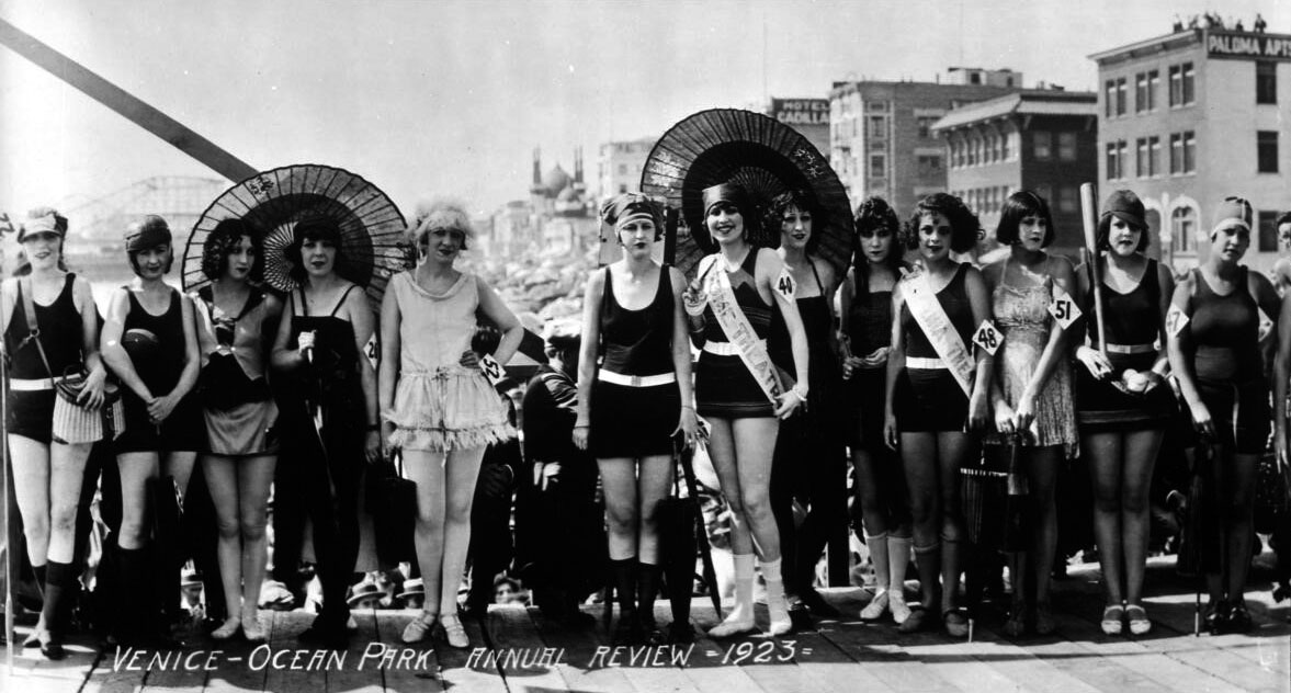
| (1923)^ – Beauty contest contestants in the Venice-Ocean Park Annual Review with the Moorish-style dome of the Ocean Park Bath House seen in the background. |
 |
|
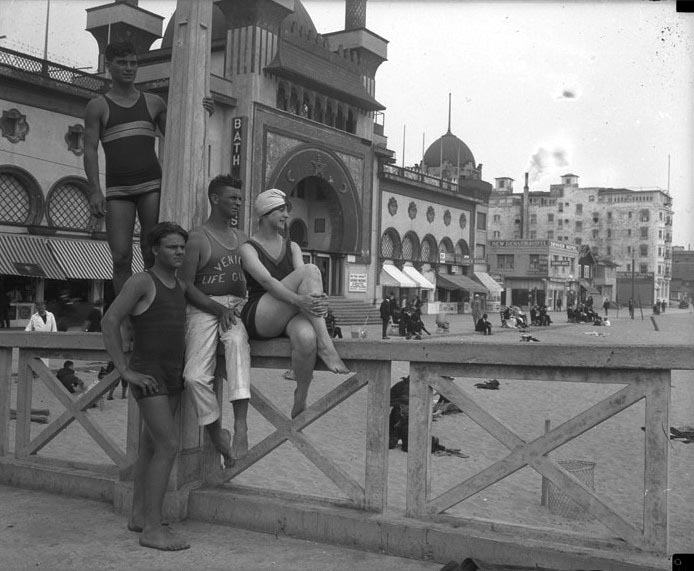
| (ca. 1925)#*#* - Bathers and lifeguard on boardwalk in front of Ocean Park Bath House. |
* * * * * |
Early Santa Monica Street Scenes
 |
|
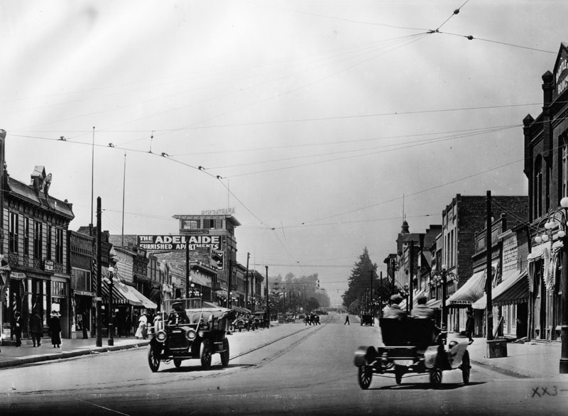
| (1910)* - View shows two automobiles driving on the 400 block of 3rd Street in Santa Monica. The Adelaide apartments can be seen on the left. Today, this is the Thrid Street Promenade. |
Auto Racing in Early Santa Monica
 |
|
| (1912)#^ - Wilshire Boulevard (then Nevada Street), a section of the fastest road race course in the world (promotional brochure), Santa Monica. |
Historical Notes Santa Monica was known for its annual road race--an event that took place from 1909 through 1919 (with a 1917-18 hiatus because of America's involvement in World War I). The Santa Monica race was established by a consortium of Southern California auto dealers who wanted to stimulate interest in cars--buying them as well as racing them--at a time when automobiles were relatively rare in Los Angeles.^ |
 |
|
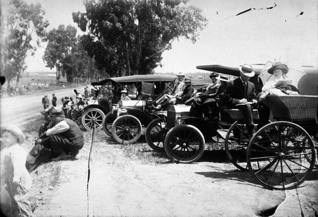
| (1912)^ – Close-up view showing spectators on the side of the road and in their automobiles on Nevada Avenue (later Wilshire Boulevard) waiting for the Santa Monica Road Race to begin. |
Historical Notes Auto racing became popular in Santa Monica. Drivers would race an 8.4-mile loop made up of city streets. The Free-For-All Race was conducted between 1910-1912. The United States Grand Prix was held in Santa Monica in 1914 and 1916, awarding the American Grand Prize and the Vanderbilt Cup trophies. By 1919, the events were attracting 100,000 people, at which point the city halted them.*^ |
 |
|
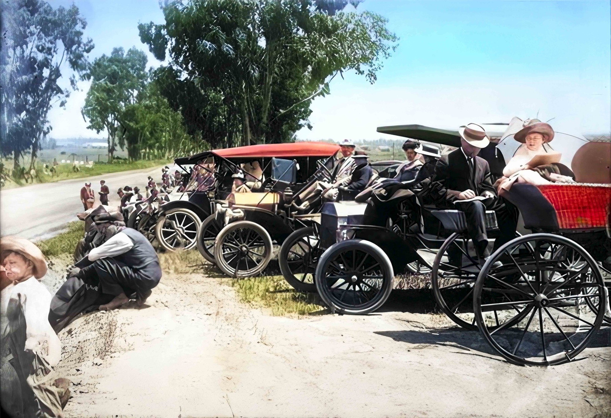
| (1912)^ – Close-up view showing spectators on the side of the road and in their automobiles on Nevada Avenue (later Wilshire Boulevard) waiting for the Santa Monica Road Race to begin. Image enhancement and colorization by Richard Holoff. |
 |
|
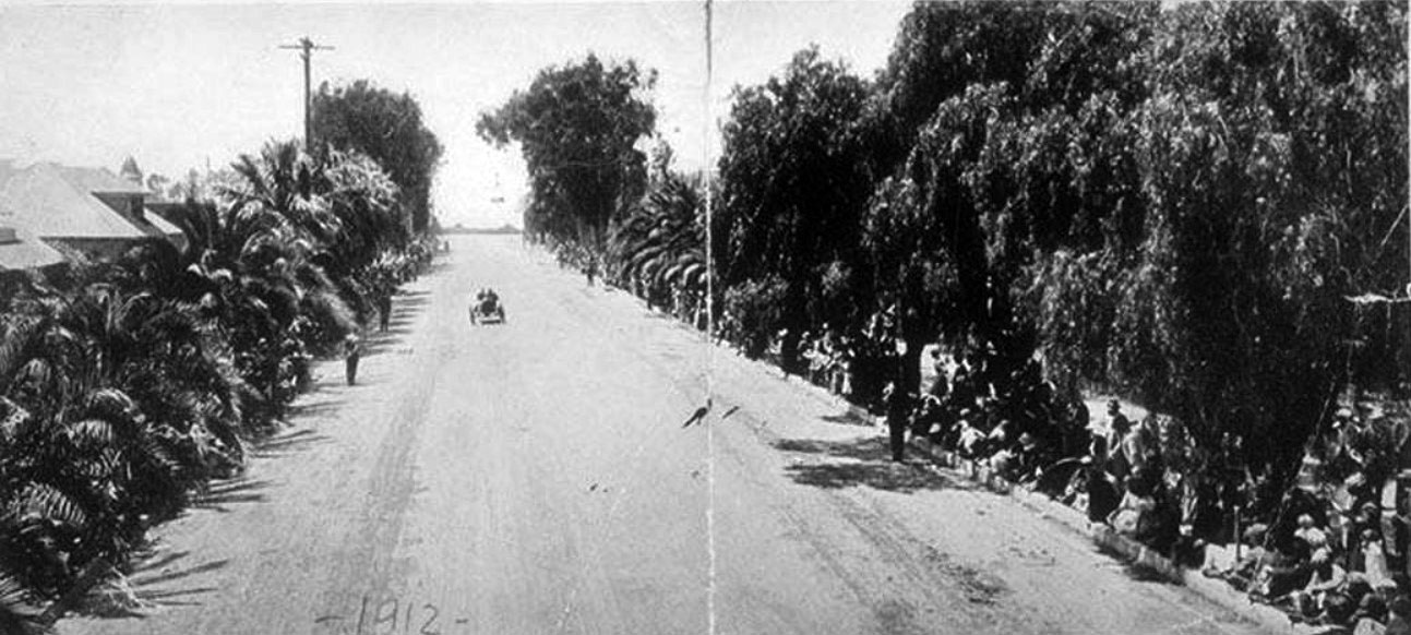
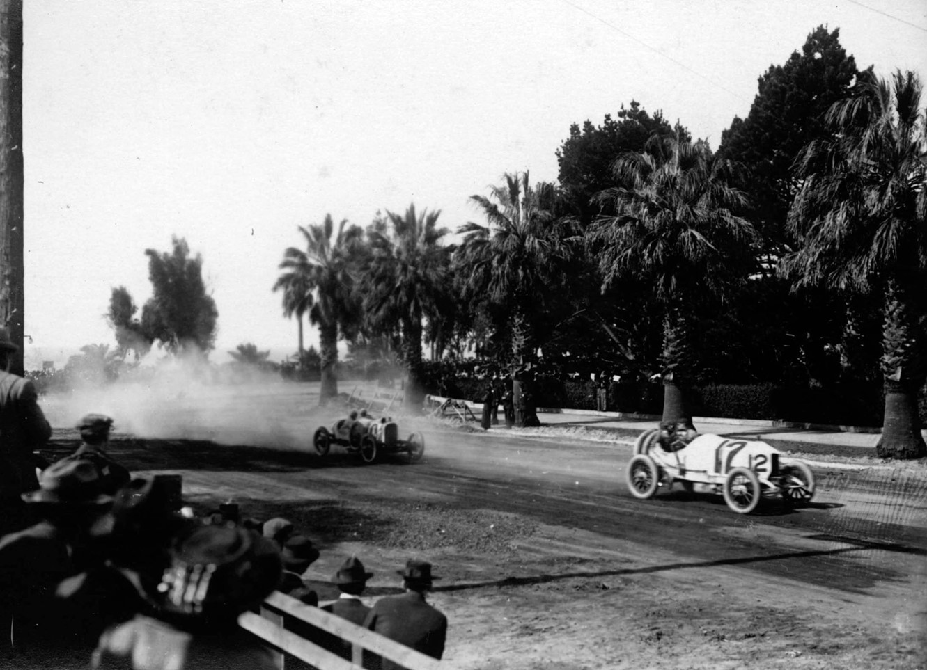
| (ca. 1912)* - Two-man race cars take a turn and kick up dust as spectators watch from the side of the dirt road. |
Historical Notes The course covered San Vicente Boulevard, Ocean Avenue and Wilshire Boulevard (then named Nevada Avenue). |
 |
|
| (1910)** - A crowd watching an automobile race near Ocean Avenue in Santa Monica. The cars have just turned from Ocean Avenue onto Nevada Avenue (later Wilshire Boulevard). This was called the "Death Curve". |
 |
|
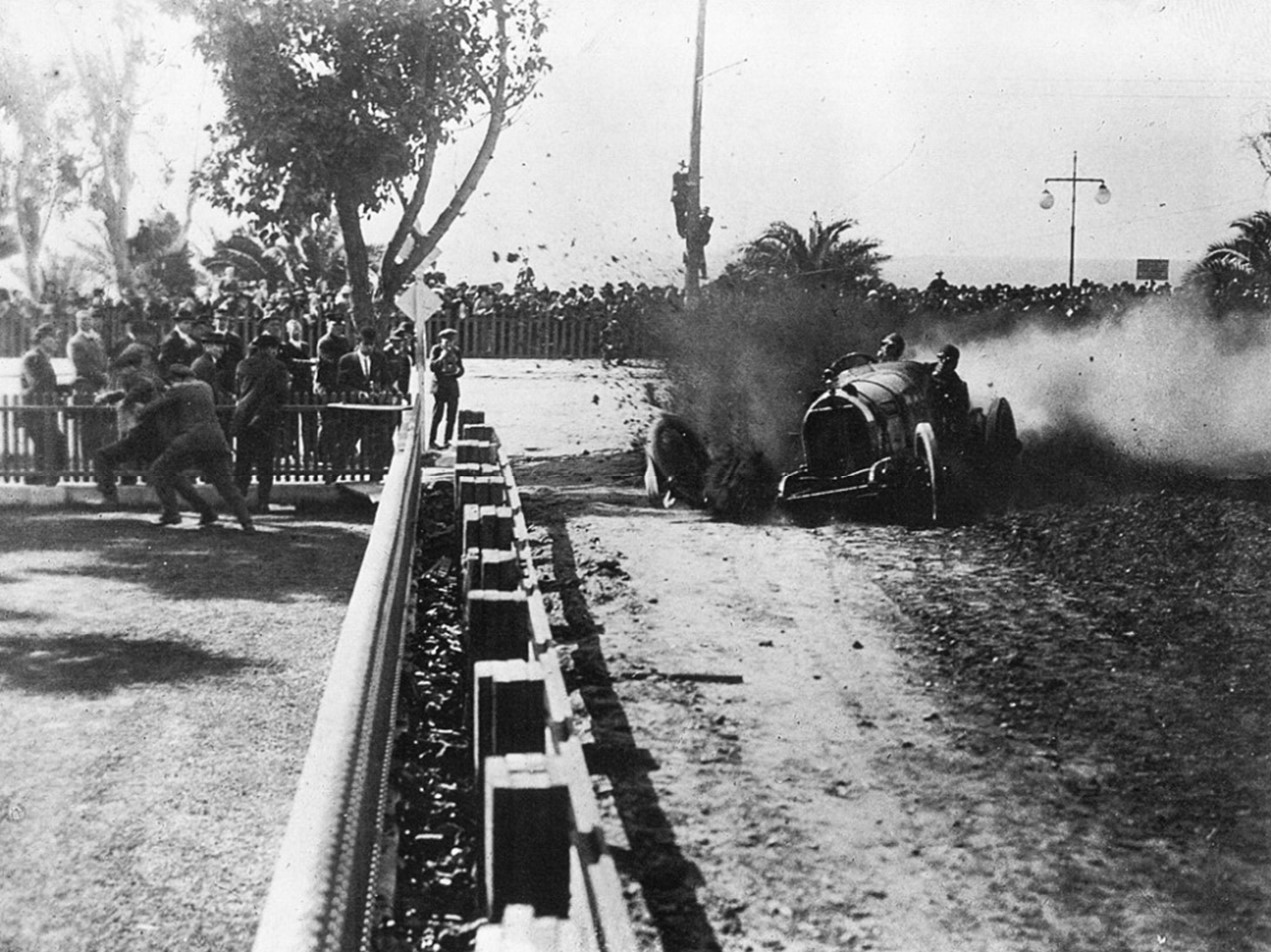
| (1914)^ – View showing the "Death Curve", located at the corner of Ocean Avenue and Wilshire Boulevard. |
Historical Notes In the 1914 Vanderbilt Cup Races, Eddie Pullen's #4 Mercer lost its front right tire at the "Death Curve" and moments later crashed into the barricade. Two days later, Pullen won the 400-mile American Grand Prix on the same course with the same car.^ |
 |
|
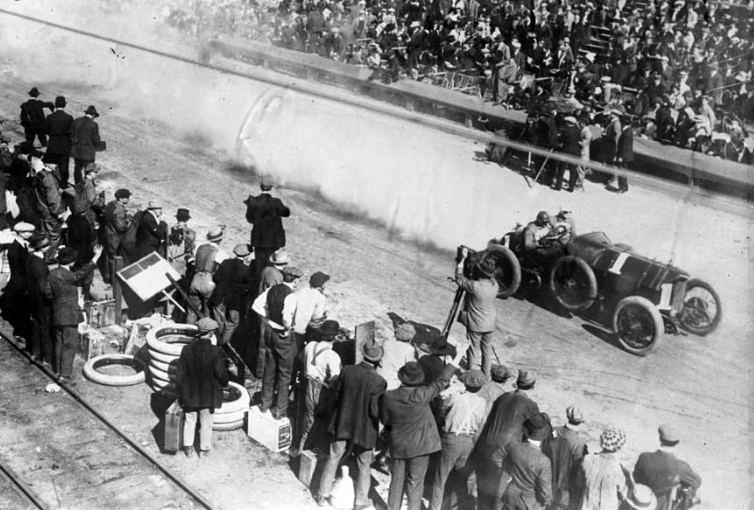
| (1914)^ - Harry Grant, two-time winner of the Vanderbilt Cup Races, driving the #1 Isotta passes the grandstands on the east side of Ocean Avenue. |
Historical Notes Both the 1914 and 1916 Vanderbilt Cup Races were held on the beautiful Santa Monica road course bordering on the Pacific Ocean. The Santa Monica 8.4-mile course consisted of three major roads; Ocean Avenue (location of the start/finish), Wilshire Boulevard and San Vicente Boulevard. The race was 35 laps for a total of 295 miles. |
 |
|
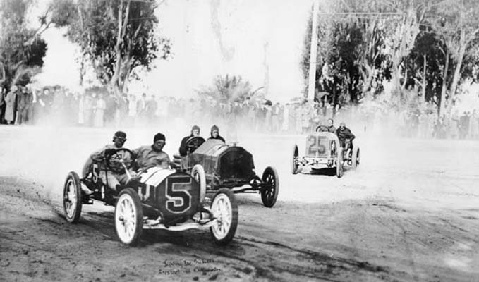
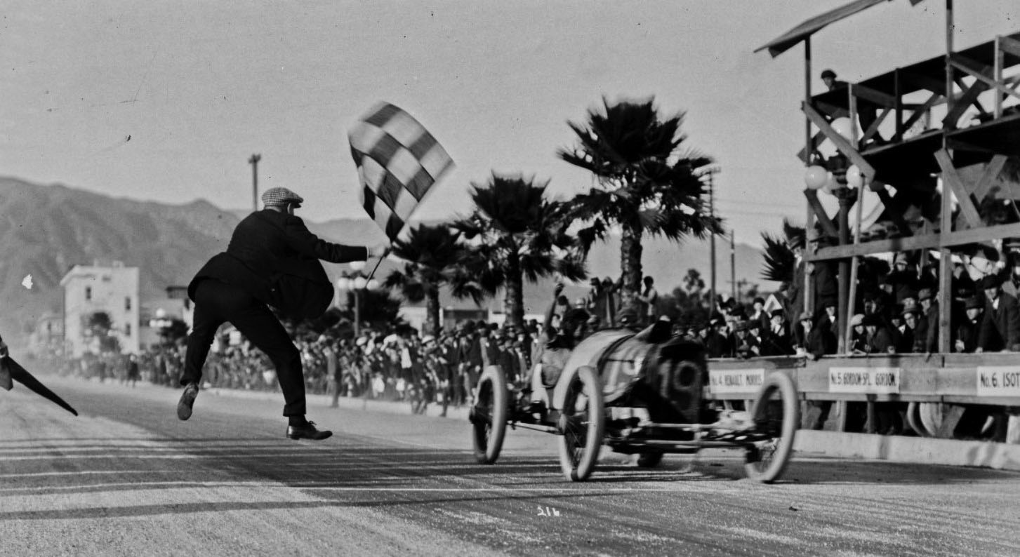
| (ca. 1916)^ – View showing the dramatic Santa Monica finish line where Eddie O'Donnell takes the checkered flag in his Number 19 Duesenberg. |
Jefferson School (Santa Monica's 1st School Building)
 |
|
| (1910)* - Jefferson School located at 1333 Sixth Street in Santa Monica. |
Historical Notes Jefferson school, originally called 6th St. School, was Santa Monica's first school building and was located on two lots on the east side of 6th St. between Santa Monica Blvd. and Arizona. This first school was a frame building and was erected in 1876.^ |
 |
|
| (1920s)* - Jefferson School, originally known as 6th Street School, located at 1333 Sixth Street in Santa Monica. |
Santa Monica City Hall
 |
|
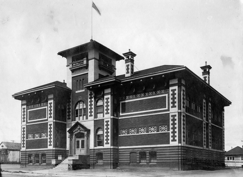
| (1903)^ - Exterior view of Santa Monica City Hall the year it was built, located at the southwest corner of 4th and Oregon (Santa Monica Boulevard). Architect: Carol Brown, addition by Henry Hollwedel. |
Historical Notes In 1903, Santa Monica constructed its first independent city hall at a site that was then just east of downtown’s main commercial core. Choosing the Mission Revival architectural style, it featured massive brick walls covered with stucco, arcades, arched windows, elevated scalloped parapets, and a corner tower.* |
 |
|
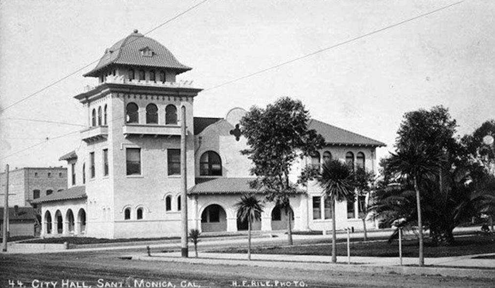
| (ca. 1917)* – Postcard view showing the old Santa Monica City Hall, located at Santa Monica Boulevard and Fourth Street. |
Historical Notes Santa Monica’s library shared space in City Hall, and a notorious dungeon-like jail was located in the basement that drew indignant protests from female civic leaders who demanded better conditions for the city’s prison population. Later a new jail adjacent to City Hall was built by Henry Hollwedel.* |
 |
|
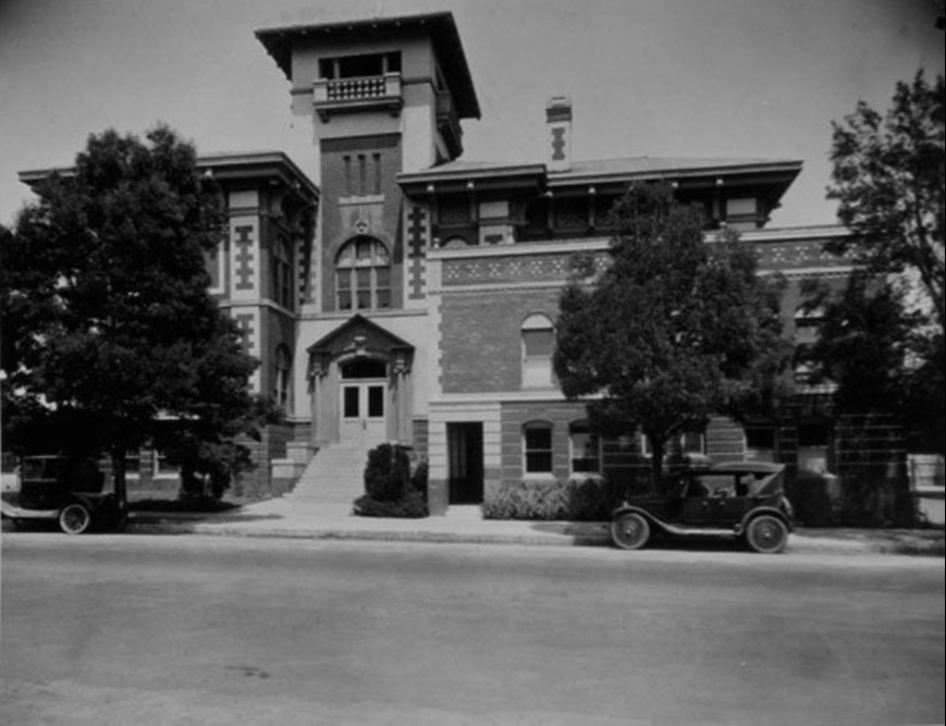
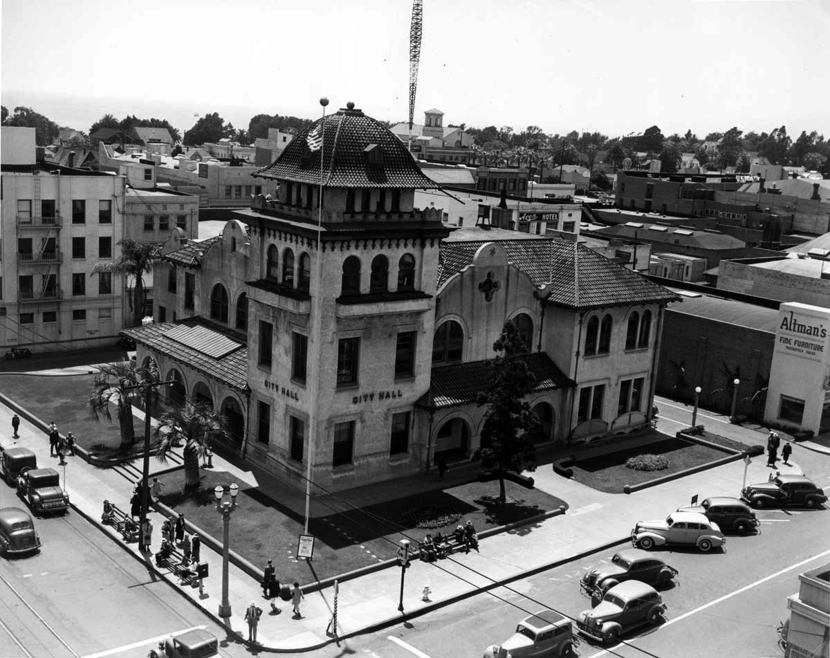
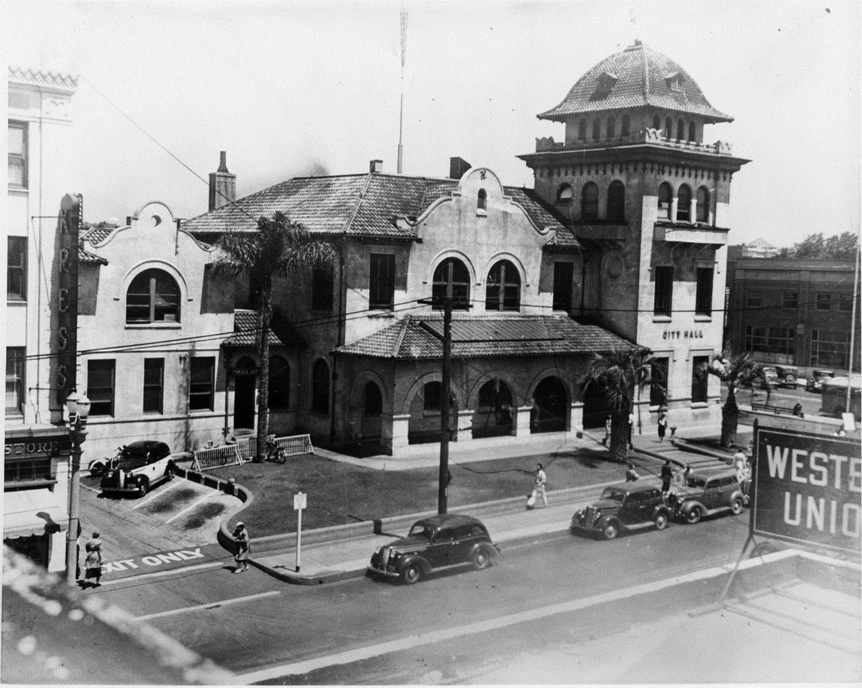
| (1930s)* - The old Santa Monica City Hall at Santa Monica Boulevard and Fourth Street. This building housed the City Hall and Police Department from 1902-1938. |
Historical Notes The Mission Revival style building designed by architects Carroll Brown and Henry Hollwedel (Henshey's Majestic Theater, Santa Monica Bay Women's Club) served as city hall and SMPD headquarters from 1902 to 1938. |
 |
|
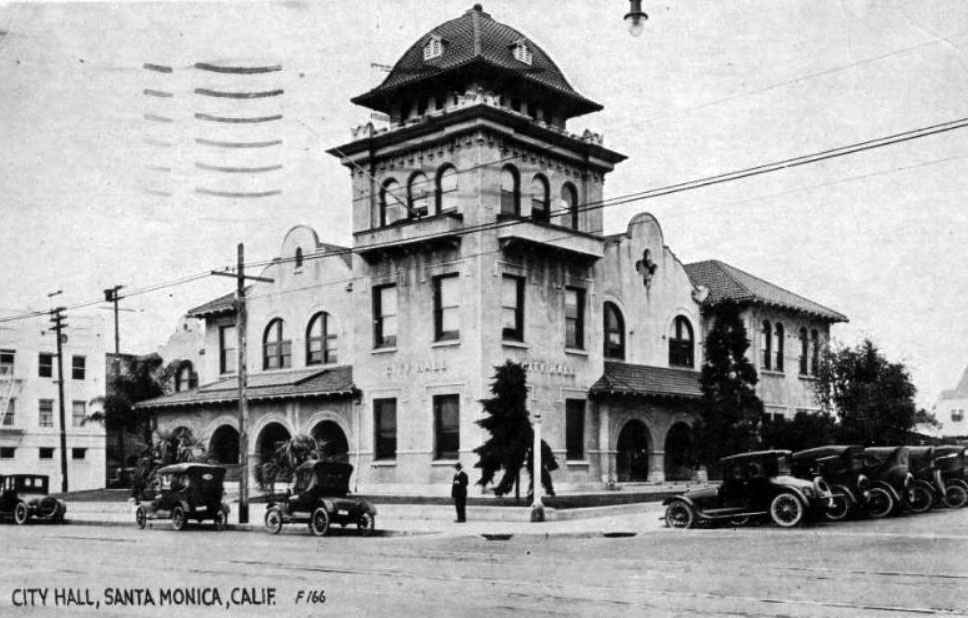
| (1930s)^ - Closer view of Santa Monica City Hall. The building shared space with the Police Dept. |
Historical Notes The old City Hall building was demolished in the late 1930’s. S. H. Kress & Co bought the property and erected a new store to replace the store on 3rd street. This building has since been demolished for new development, but the 3rd Street building survives.*##^ Today’s City Hall at 1685 Main Street replaced this earlier structure in 1939.^ |
Vitagraph Film Company
 |
|
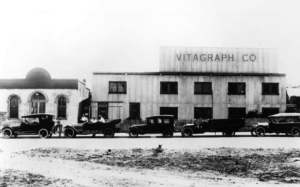
| (1912)^ – View showing early model cars parked in front of Vitagraph Film Company and Rapp Saloon located on the 1400 block of 2nd Street in Santa Monica. |
Historical Notes The Vitagraph Company was one of the biggest motion picture studios in the early era of American film. Originally founded in Brooklyn, NY in 1897, they established another studio on 2nd Street in Santa Monica in 1911. The photo above was taken the following year, 1912, but they only lasted there until 1915 because the persistent fog made filming so difficult that they moved to 4151 Prospect Avenue in Hollywood (Click HERE to see the Hollywood Studio). In 1925, they were bought by Warner Bros.* |
Rapp Saloon
 |
|
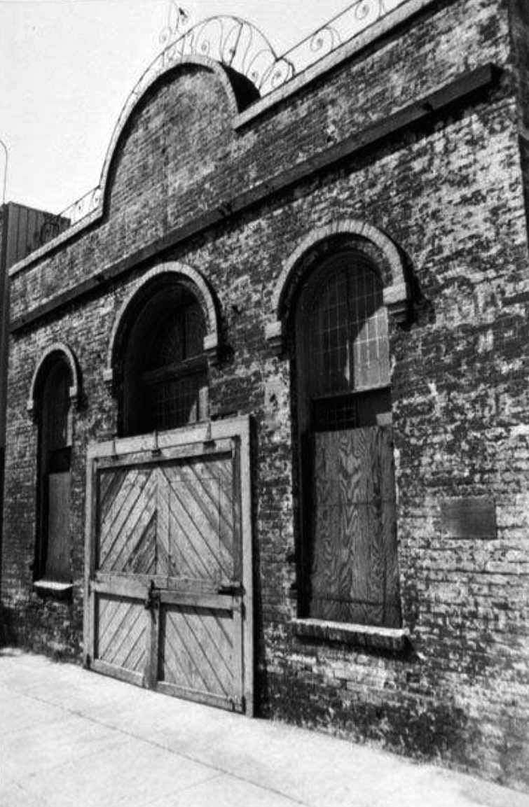
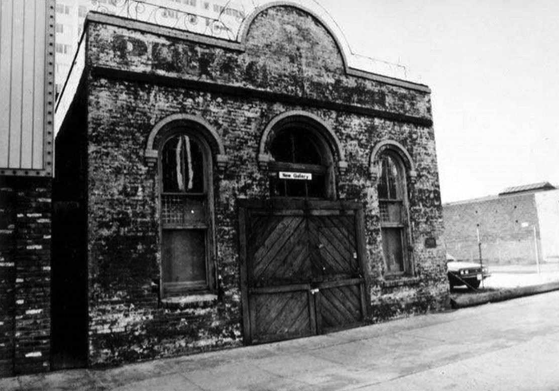
| (1975)#^ – Close-up view of Santa Monica's oldest masonry building, the Rapp Saloon located at 1438 Second Street. It was built in 1875 and designated as a landmark in 1975. |
Historical Notes A remarkable survivor from the year Santa Monica was born, this small brick building was constructed as a beer hall by William Rapp. An 1877 newspaper ad promoted the “Los Angeles Beer Garden” with fresh Los Angeles beer always on hand.^ |
 |
|
| (1983)#^ - Rapp Saloon, 14438 Second Street, Santa Monica. Built in 1875 by William Rapp, this is the oldest masonry building in Santa Monica. |
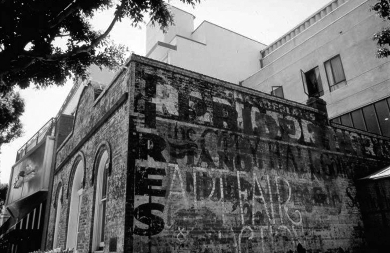
Historical Notes The arches give this vernacular building an Italianate air. It has gone through many incarnations in its long life, even serving briefly as City Hall in 1888-1889. From 1911 to 1914 it was used by the Vitagraph Film Company, an early movie studio. It’s also been home to the Salvation Army, a radiator repair shop, a piano tuning shop and an art gallery. Old painted signs on the north wall memorialize some of the previous occupants.^ |
 |
|
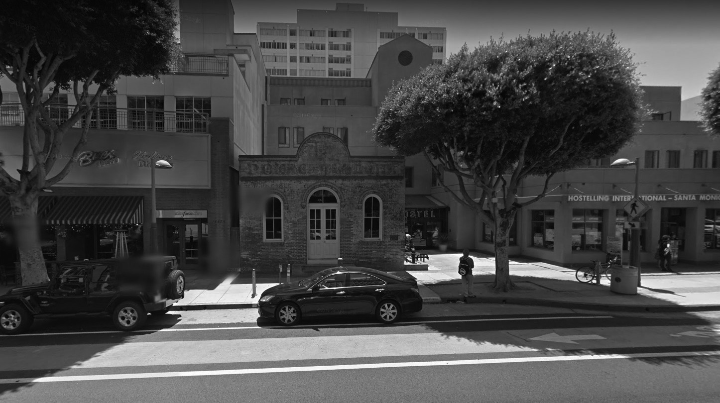
| (2001)#^ – Side view of the Rapp Saloon, 1438 Second Street, oldest masonry building in Santa Monica built in 1875 by William Rapp. |
Historical Notes Saving the Rapp Saloon took several decades of effort. Vacant and abandoned since 1959, the owner hoped to sell and relocate the building so that this prime location could be redeveloped. It was named the first landmark in the city in 1975, and the city offered to support the relocation. Ideas floated to use the building as a historical museum. By 1984 no viable purchaser had emerged with a realistic plan for re-use; and the owner threatened demolition. Finally, in 1986, the American Youth Hostel acquired the property with the intention of preserving and re-using the historic landmark. New construction wraps around the Rapp Saloon, visible in its entirety – a model of combining new construction with historic preservation.^ |
 |
|
| (2015)** – Google street view showing the Rapp Saloon as it appears today. |
Historical Notes The Rapp Saloon, at 1438 Second St., was built in 1875 and is the oldest surviving brick building in the city. This one-story structure was designed for William Rapp by a contractor known only as Mr. Freeman. The building was constructed by Spencer & Pugh bricklayers and plasterers. It was the first masonry structure in Santa Monica. The Rapp Saloon even served as Santa Monica’s City Hall for two years, and was the city's first landmark.* |
Santa Monica High School
 |
|
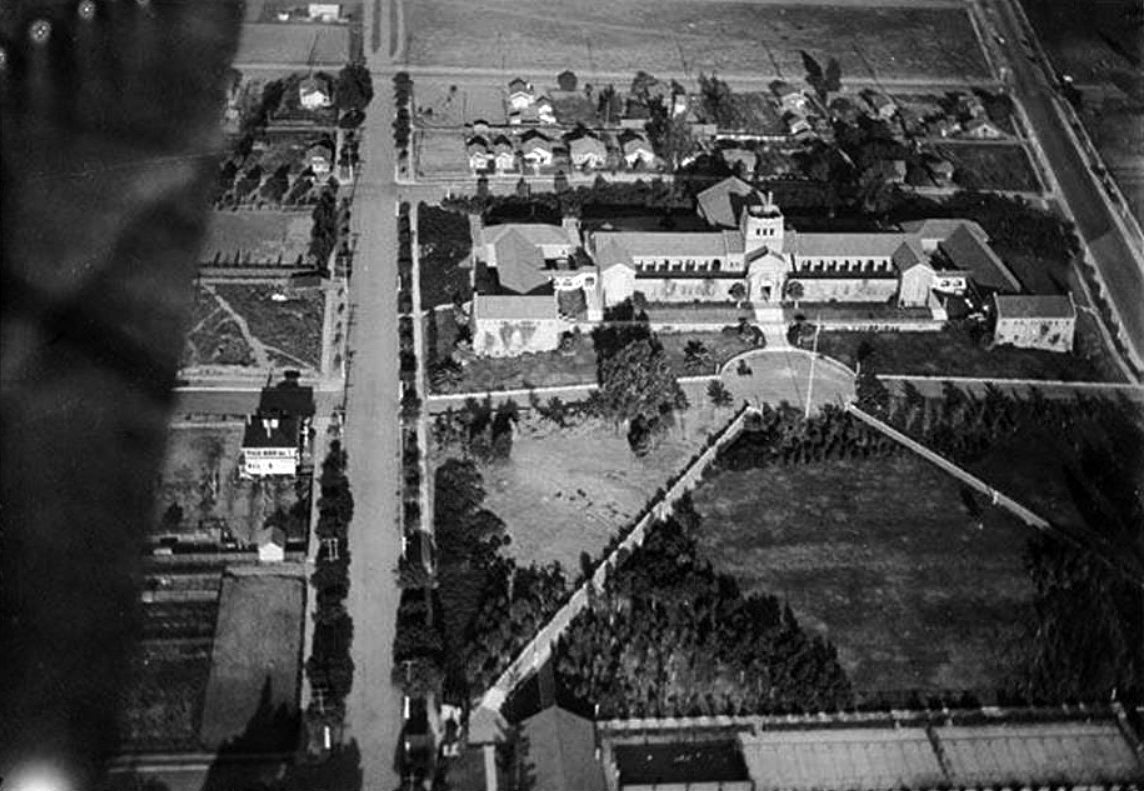
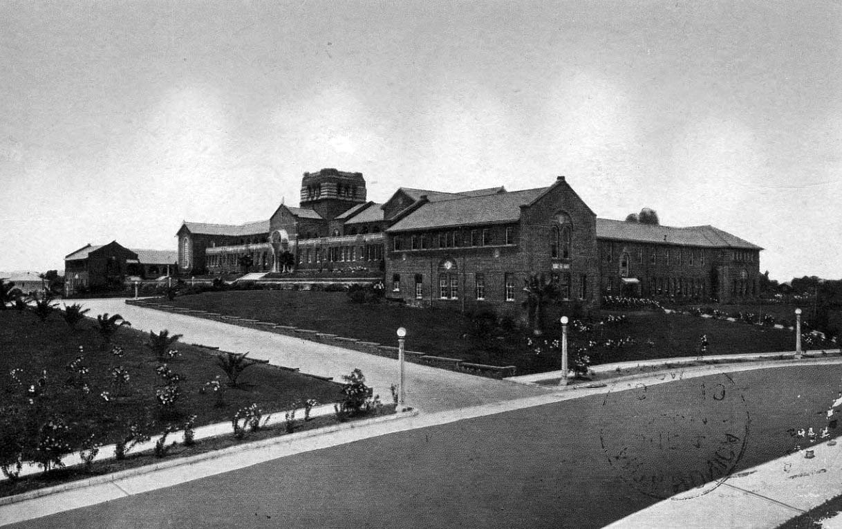
| (1916)#^ – Aerial view of Santa Monica High School, located at 601 Pico Boulevard. |
Historical Notes Santa Monica High School was founded in 1884. It changed location several times in its early years before settling into its present campus at 601 Pico Boulevard. The "new" campus opened in 1906 with one building, the current History building, with an enrollment of 50 students. The school sits on the hilltop of what is now 6th Street and Pico Boulevard, from which one can see the Pacific Ocean.*^ |
 |
|
| (ca. 1919)*^ - Postcard view of Santa Monica High School located at 601 Pico Boulevard. |
 |
|
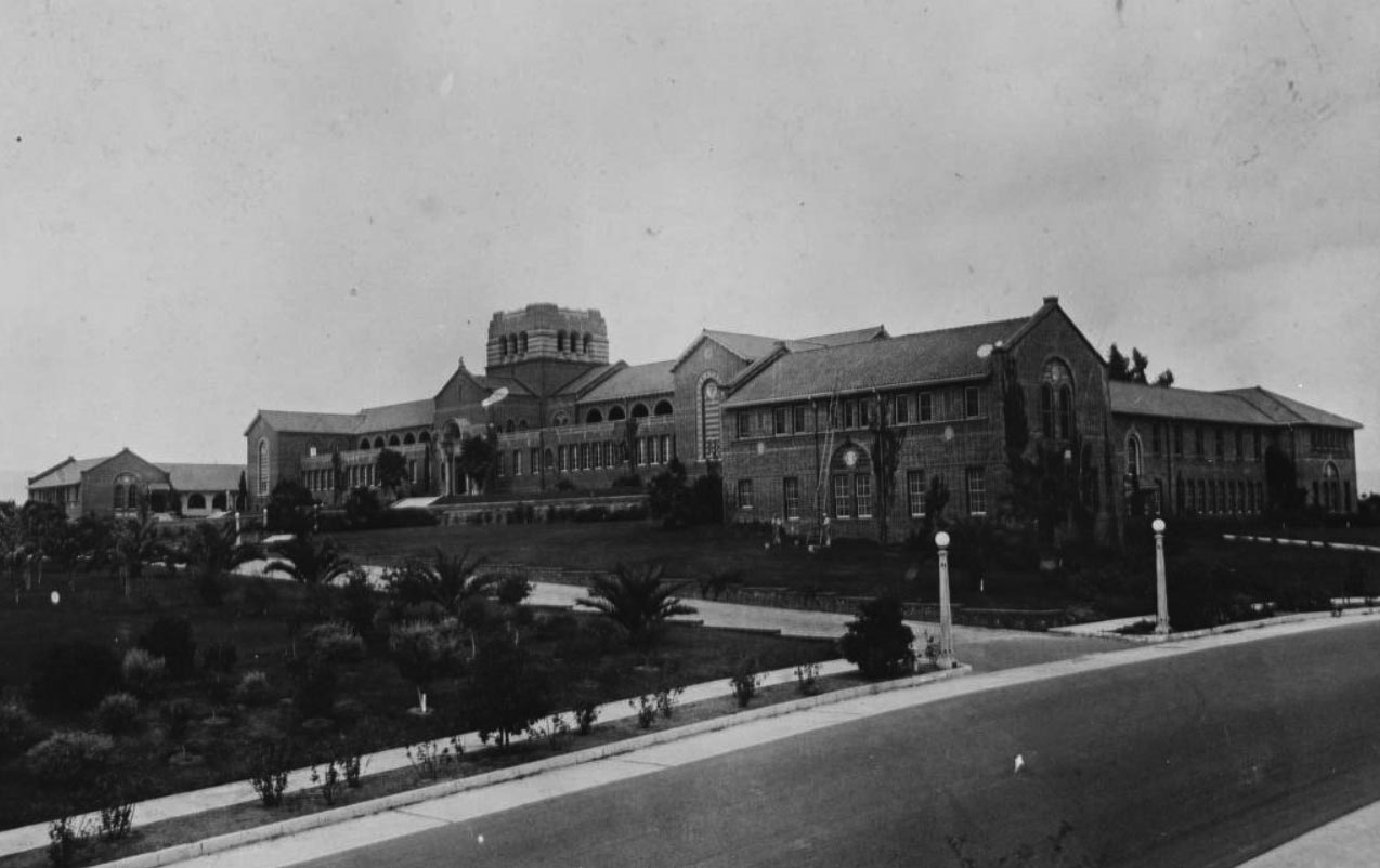
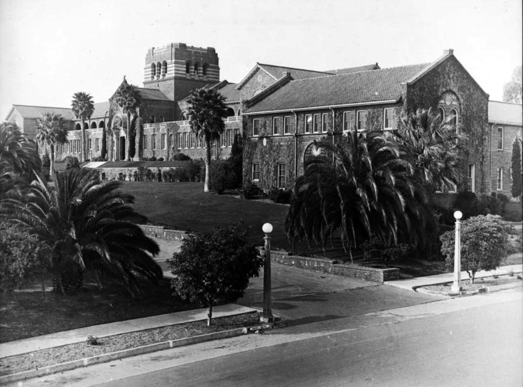
| (ca. 1922)#^^ - Image of the main entrance wing of Santa Monica High School and grounds on Pico Boulevard in Santa Monica. |
 |
|
| (1924)** - Exterior view of Santa Monica High School, showing the main entrance and right wing. The main entrance to the multi-story brick building is seen at left center. The right wing, its walls covered in ivy, protrudes toward the foreground. The building is fronted by lawns and palm trees. A paved street and sidewalk run diagonally through the lower right of the image. The high school building was erected in 1912 and replaced during 1936 and 1937. |
 |
|
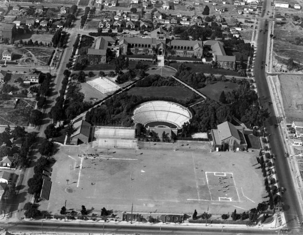
| (1925)#^^ - Aerial view of the Santa Monica High School campus showing the athletic field and Open Air Memorial Theater (later renamed the Memorial Greek Amphitheatre) bordered by 4th Street at bottom and Pico Boulevard at right. |
Historical Notes In 1921, the Open Air Memorial Theatre (now called the Greek Amphitheatre) was built to honor the Santa Monicans who served in World War I. One of the best examples of the classical Greek style in Southern California, the amphitheatre was built after Santa Monica passed a $30,000 bond measure to fund its construction. Barnum Hall Theater, originally called "the Auditorium," was built in 1937 by the Works Progress Administration (WPA) to be the Civic Auditorium of Santa Monica and host school events as well. The campus also added six buildings during this period: the Language, English, Business, History, Administration and Music buildings. In 1952, Santa Monica High School was finally expanded to what it is now, 33 acres, and two new buildings were built, the Science and Technology D.M. buildings. As the school aged, renovations took place in Barnum Hall and the Music building was completely rebuilt. The school has been a location in a number of films. Most famously, it is the high school setting in Rebel Without a Cause where James Dean walks up the History Building stairs.*^ |
* * * * * |
Please Support Our CauseWater and Power Associates, Inc. is a non-profit, public service organization dedicated to preserving historical records and photos. Your generosity allows us to continue to disseminate knowledge of the rich and diverse multicultural history of the greater Los Angeles area; to serve as a resource of historical information; and to assist in the preservation of the city's historic records.
|
More Historical Early Views
Newest Additions
Early LA Buildings and City Views
History of Water and Electricity in Los Angeles
* * * * * |
References and Credits
* LA Public Library Image Archive
^^The California History Room, California State Library
^*LMU Digital Collection: Arcadia Hotel
#^ Santa Monica Public Library Image Archive
+# Santa Monica Mirror: Statue of Santa Monica
+^ Santa Monica Landmarks: Looff Hippodrome
## Library of Congress: Santa Monica Bay ca. 1908; Ferris Wheel
***Cinema Treasures: El Miro Theatre; Criterion Theatre and Thrid Street; Criterion Theatre
**^Noirish Los Angeles - forum.skyscraperpage.com; Deauville Club; Palisades Park Cannon
^^*Deviantart-Studio5: Santa Monica Beach
^^#University of California Digital Library: The Deauville Club
^^+Stanford University Revs Digital Library
*^#Nuestra Señora la Reina de los Ángeles: losangelespast.com
*#*KCET: A Historical Look at SoCal's Beaches
*#^Santa Monica Public Library
^#*Santa Monica History Museum
^x^Facebook.com: Venice, Ca, Ocean Park, & Santa Monica in the 20th Century
^#^Framework.latimes.com: Santa Monica Beach, 1936; Santa Monica Aerial, 1937; McClure Tunnel
^##The Malibu Times: Historic Las Flores Canyon
+##Facebook.com: Vintage Los Angeles
*#*KCET: A Historical Look at SoCal's Beaches; Arch Rock and Castle Rocks; When L.A.'s Most Famous Streets Were Dirt Roads
**#The Central Tower Building - City Landmark Assessment and Evaluation Report
#**MTA Transportation and Research Library Archives
#^^Huntington Digital Library Archive
#*^Electric Railway History: Venice Trams
#+#Facebook.com: Photos of Los Angeles
^^^California State Library Image Archive
****Life.time.com: Stoked-Life Goes Surfing
^^^^Pinterest/Santa Monica Past: Santa Monica Canyon Flood; Santa Monica Airport/Clover Field; Douglas Aircraft
*^*^Santa Monica Beach Stories
^**^California Legends: Santa Monica at the End of Route 66
*^^*Discoverlosangeles.com: Santa Monica
*^^^NonPhotography.com-Nika: Santa Monica Pier
***^History of the Fairmont Miramar Hotel and Bungalows
^***Southern California Beaches: Santa Monica Beach
**#*Santa Monica via Beverly Hills Line - uncanny.net
*#**Los Angeles Westerners Corral: Venice Miniature Railway
*##*AkamaIdivers.com: Pacific Ocean Pier
*##^Santa Monica Conservancy; Henshey’s Tegner Building
*#*#Los Angeles Then and Now: Douglas' Dream Took Wing in Santa Monica
*#^#Flickr.com: Walking Over Santa Monica
^#*#Venice History: Roller Coasters and Carousels
^^*#Oceanpark.wordpress.com: Ocean Park Time Line
*^*#Santa Monica Municipal Airport
*^^#LAistory: The Santa Monica Pier
#*^*Cardcow.com: Marion Davies' Mansion
#***California 2012 - Travel w/ Terry: Annenberg Beach House
#*#*Flickr.com: Michael Ryerson
#^#*Denver Public Library Image Archive
#^^^Survey LA: Brentwod-Pacific Palisades Community Plan Area
#^*^Santa Monica Landmark Properties
#^^*Pinterest.com: Old Hollywood
#^#^Paslisades Park: smgov.net
##*^Facebook.com: Hollywood's Garden of Allah Novels, Martin Turnbull
##^^MartinTurnbull.com: Gables Beach Club
****^Facebook.com: West San Fernando Valley Then And Now
^*^*^Wehadfacesthen.tumblr.com
*^*^*SantaMonicaPier.com
*#*#*Venice Miniature Railroad - Jeffrey Stanton
*^ Wikipedia: California State Route 1; History of Santa Monica; Alphonzo Bell; Venice; California Incline; Route 66; Third Street Pomenade; Santa Monica Pier; Casa del Mar Hotel; Pacific Palisades - Castellammare; Parkhurst Building; Venice Canal HIstoric District; Annenberg Community Beach House; Santa Monica High School; Jack Dempsey; Muscle Beach; Wilshire Boulevard
< Back