Early Views of the San Fernando Valley
Historical Photos of the San Fernando Valley |
 |
|
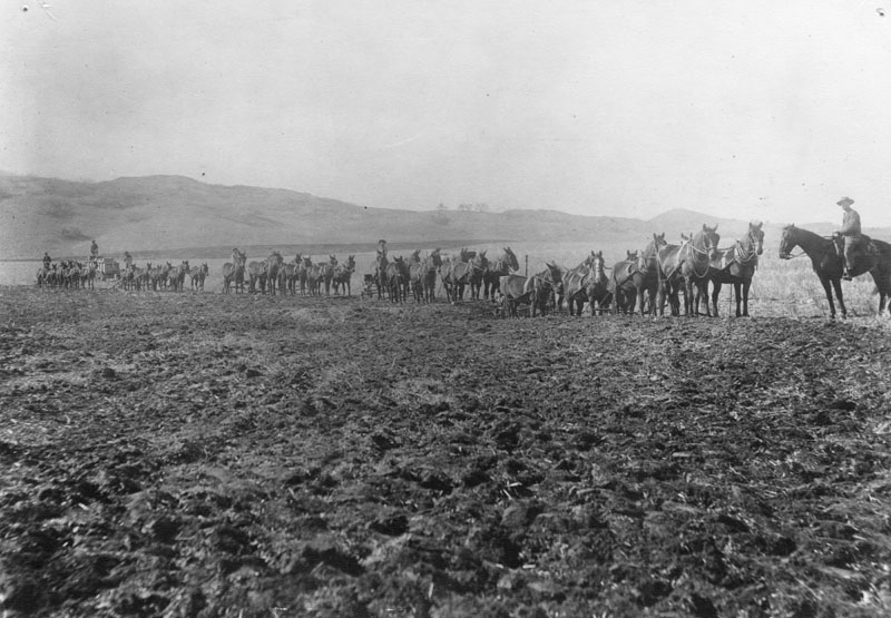
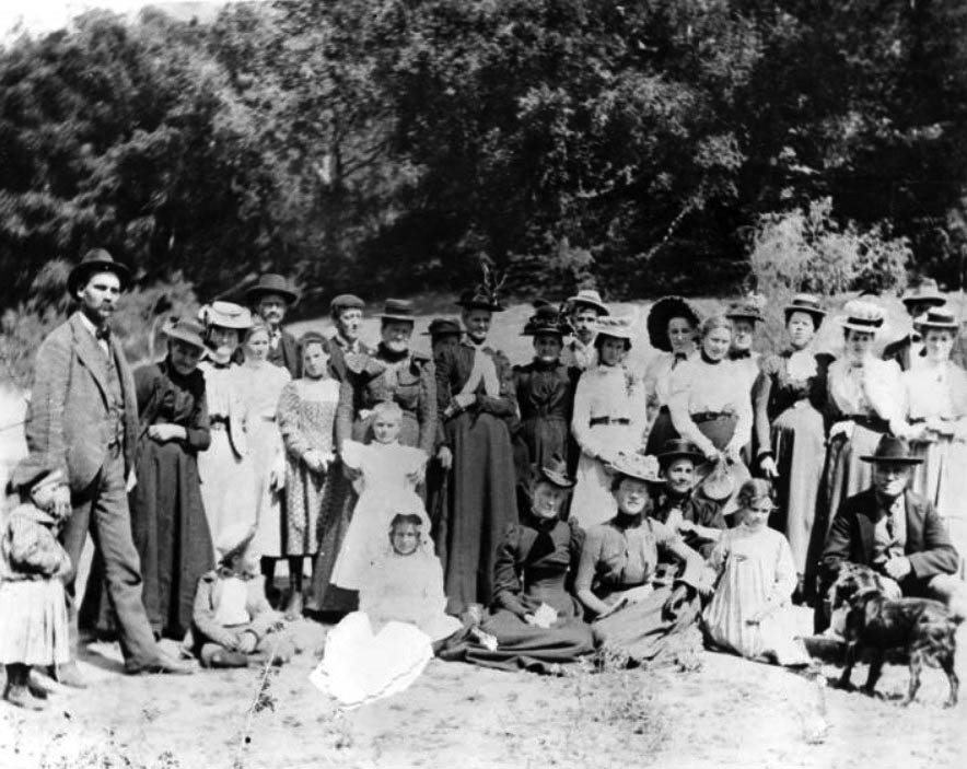
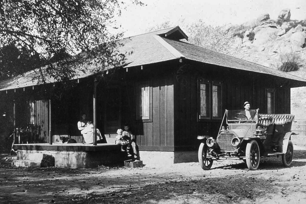
| (1880s)* - Horses plowing a field in the San Fernando Valley in the early 1880s. Al Redden is the foreman, viewing the teams of eight horses each. |
San Fernando Valley Historical Background The Tongva, Tataviam (north), and Chumash (west) Indians had lived and thrived in the Valley and its arroyos for over 8,000 years. They had numerous settlements, and trading and hunting camps, before the Spanish arrived and took their homeland in 1797 for the Mission San Fernando Rey de España and Las Californias ranchos. Rancho Encino was short lived, though, with the land traded so a Mission could be sited and built there. Mission San Fernando Rey de España was established in 1797 as the 17th of the twenty-one missions. The land trade granted Juan Francisco Reyes was similarly named Rancho Los Encinos, and was also located besides springs at the present day location of Los Encinos State Historic Park in Encino. Later the Mexican land grants of Rancho El Escorpión (West Hills), Rancho Providencia and Rancho Cahuenga (Burbank), and Rancho Ex-Mission San Fernando (rest of valley) were established to cover the San Fernando Valley.*^ |
 |
|
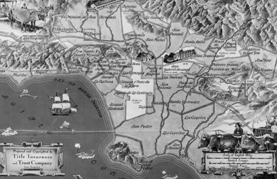
| (1919)^^ - Map showing the old Spanish and Mexican ranchos of Los Angeles County. In the upper left can be seen the San Fernando Mission as well as the three main Ranchos that made up the San Fernando Valley at the turn of the century: Rancho Ex-Mission de San Fernando, Rancho El Escorpión, and Rancho El Encino. |
 |
|
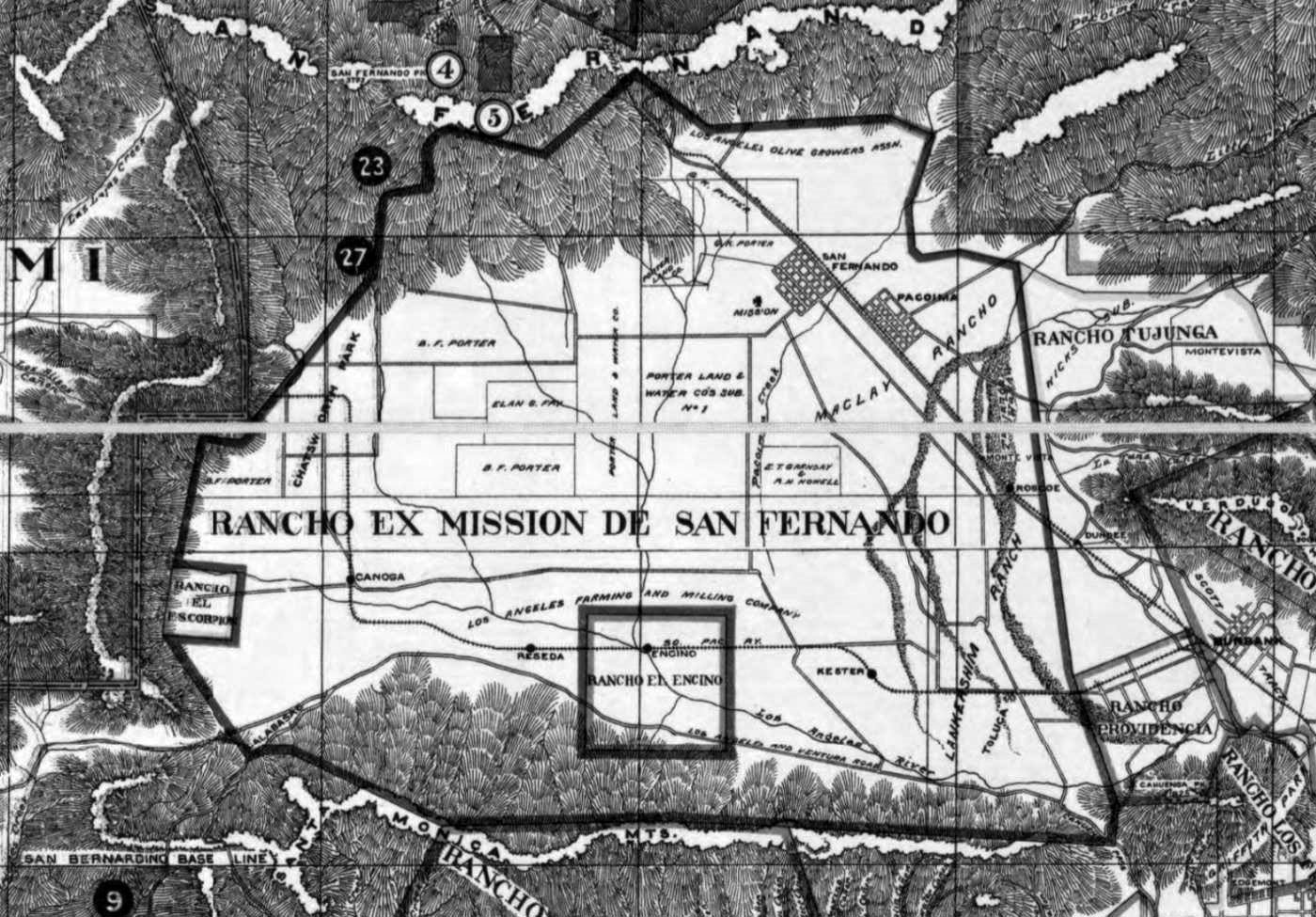
| (n.d.)#^*^ – Early map showing a more detailed view of the three main Ranchos that made up the San Fernando Valley at the turn of the century: Rancho Ex-Mission de San Fernando, Rancho El Escorpión, and Rancho El Encino. |
Oldest Known Photograph of the San Fernando Valley
 |
|
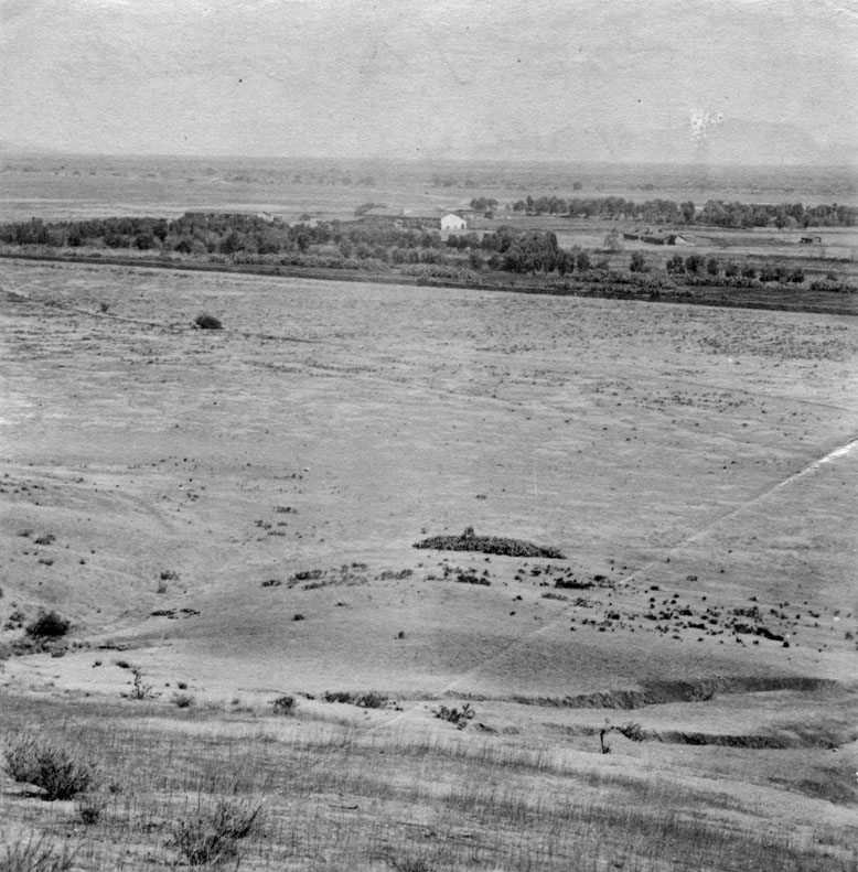
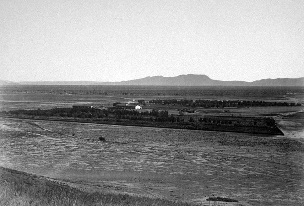
| (1873)* - This is the first known photograph of the San Fernando Valley as seen in 1873. View is looking to the south, showing San Fernando Rey de España Mission in the center of the photograph. Apart from the mission, the vast land appears to be completely deserted. Mission San Fernando Rey de España is located at 15151 San Fernando Mission Boulevard. |
Historical Notes Founded by father Fermín Lasuén on September 8, 1797 in Mission Hills, Mission San Fernando Rey de España (originally La Misión del Señor Fernando, Rey de España) is located on the former settlement of Encino Rancho. It was the seventeenth mission built in Alto California. It was built in a quadrangle, similar to other missions, in which the church makes up one corner. The Convento stands apart from the quadrangle.* |
 |
|
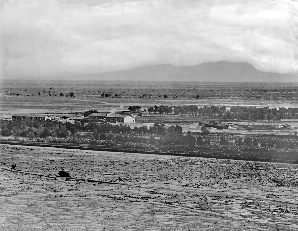
| (ca. 1875)* – Panoramic view of the San Fernando Mission looking south across a largely unimproved San Fernando Valley. In the distance are the Hollywood Hills with Cahuenga Pass (low point on the horizon in the upper-right) and the back of Mount Lee (highest peak and ridgeline). |
Historical Notes In 1821, after the successful Mexican War of Independence from Spain, the Mission San Fernando became part of Alta California, Mexico. In 1834, the Mexican government began redistributing the mission lands. In 1846, the Mexican land grant for Rancho Ex-Mission San Fernando was issued by Governor Pío Pico. It was bounded on the north by Rancho San Francisco and the Santa Susana Mountains, on the west by the Simi Hills, on the east by Rancho Tujunga, and on the south by the Montañas de Portesuelo (Santa Monica Mountains).*^ |
 |
|
| (ca. 1875)^^ - A closer view of the San Fernando Mission and the Valley looking south, circa 1875. A clearing stands in the foreground, separated from the buildings of the mission by a line of trees. The buildings stand mainly to the left: a long, two-story adobe can be seen most prominently, surrounded by smaller buildings. The ruins of shorter adobes stand to the right as well. Dirt roads and tree-dappled flatland extends behind them towards the mountains in the distance. |
Historical Notes Rancho Ex-Mission San Fernando was a 116,858-acre Mexican land grant in 1846 by Governor Pío Pico to Eulogio de Celis. The grant derives its name from the secularized Mission San Fernando Rey de España, but was called ex-Mission because of a division made of the lands held in the name of the Mission — the church retaining the grounds immediately around, and all of the lands outside of this were called ex-Mission lands. The grant encompassed most of the present day San Fernando Valley.*^ |
San Fernando Mission
 |
|
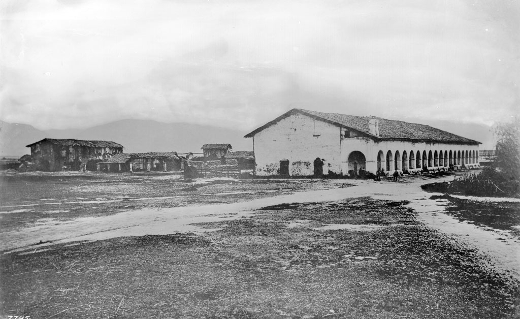
| (ca. 1870)^^ - Exterior view of the Mission San Fernando, ca.1870. Two dirt paths enter in from the foreground, intersecting at the adobe cloister of the mission, which stands to the right of center. A collection of archways holds the eaves of the terracotta-tiled roof up over the cloister's patio. More adobe buildings can be seen to the left, with two-story adobe building standing to the left of an older cloister whose roof has collapsed. |
Historical Notes In 1874, after the death of Eulogio de Celis, the family sold their northern half of Rancho Ex-Mission San Fernando to northern Californians, California State Senator Charles Maclay and his partners George K. Porter, a San Francisco shoe manufacturer, and his cousin Benjamin F. Porter. The Porters’ land was west of present day Sepulveda Boulevard including most of Chatsworth, and the Maclay land was east of Sepulveda Boulevard. Roscoe Boulevard was the border on the south, with a syndicate led by Isaac Lankershim acquiring the southern half of the Valley.*^ |
 |
|
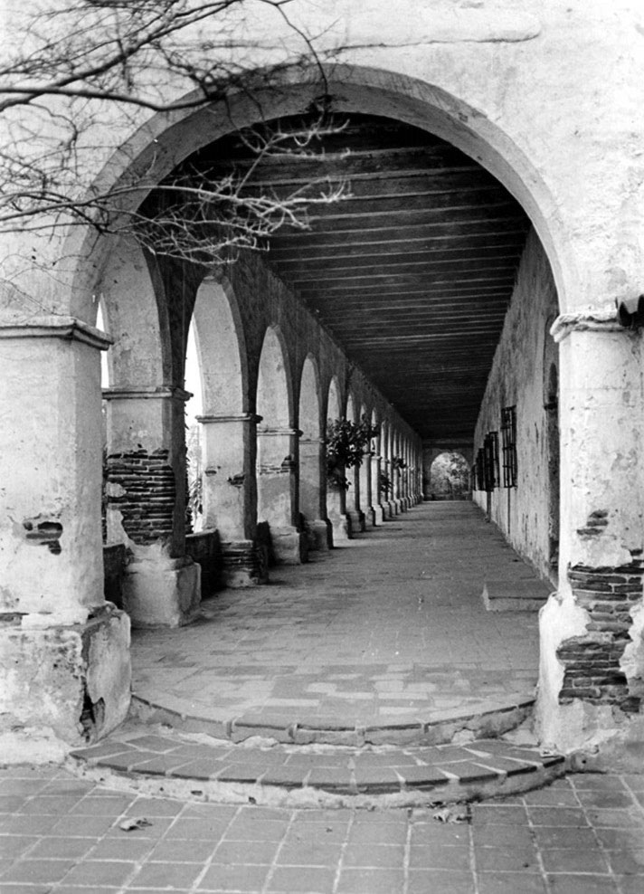
| (1800s)* - View of the San Fernando Mission's Convento Building, also known as the "Long Building." Two families stand next to their horse-drawn carriages, which have stopped along the road that would eventually become "El Camino Real". |
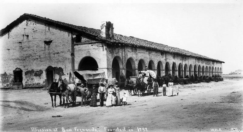
Historical Notes Construction of the arched Convento Building began in 1810. It took 13 years to construct and was completed in 1822. Most noted for its 21 Roman arches, it is the largest two-story adobe structure in California. * |
 |
|
| (1897)^ - The convento building at San Fernando, Rey de Espana Mission as it existed in 1897. Timber roof supports are visible. Donor: Milt Fries. |
Historical Notes The San Fernando Mission was abandoned in 1847. From 1857 to 1861, part of it was used as a stagecoach station. By 1888, the hospice was used as a warehouse and stable, and in 1896, the quadrangle became a hog farm. In 1896, Charles Fletcher Lummis began a campaign to reclaim the property, and conditions improved.* |
Click HERE to see more in Early Views of the San Fernando Mission |
Rancho Los Encinos
 |
|
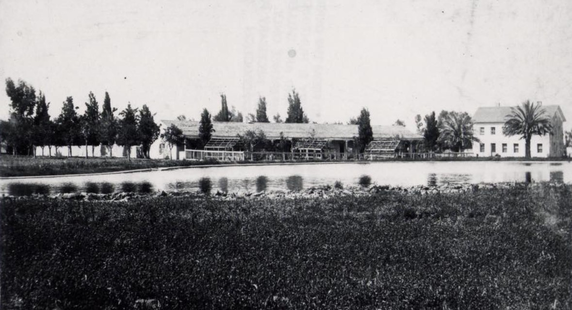
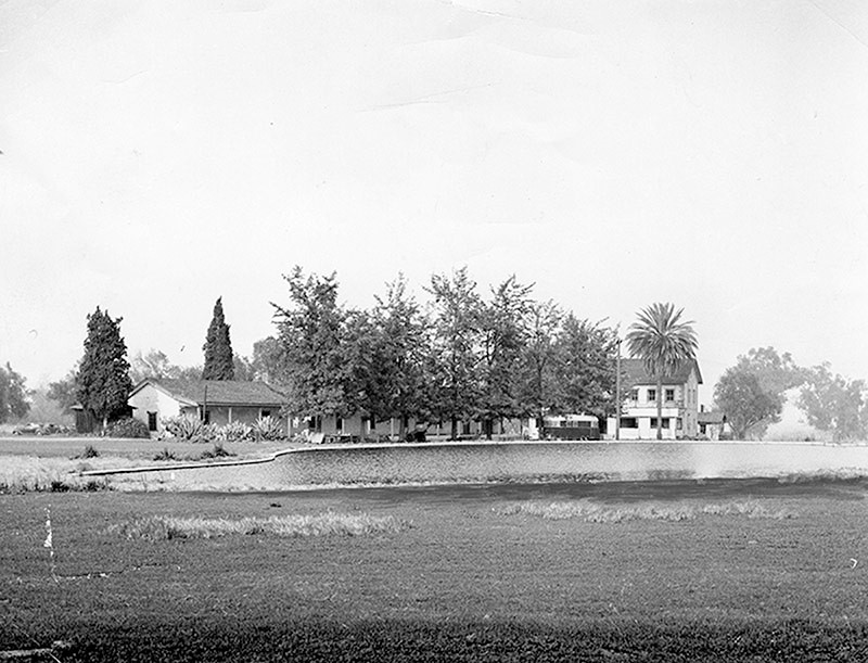
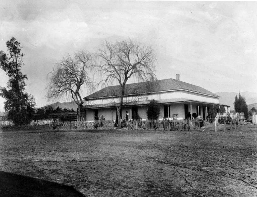
| (1880s)*^*^* - Panoramic view showing Rancho Los Encinos. This is the best surviving photograph of Rancho Los Encinos during its time of greatest prosperity. All the key elements of the current park are visible, as well as some interesting frame structures (probably used for grapevines) and a fence or structure running West from the South end of the De La Ossa adobe. |
Historical Notes Because of its water supply from a natural spring, the Franciscan padres used Encino as their headquarters while exploring the valley before establishing Mission San Fernando in 1797. In 1849 Vincente de la Osa built an adobe with nine rooms on Rancho Los Encinos. Twenty years later (1869), Eugene Garnier bought Rancho Los Encinos and, in 1872, built a French Provincial two-story limestone house adjacent to the existing adobe. He was a French Basque and the house was similar to those in his homeland.#^ The Garniers were energetic builders, and added much to the Rancho. They built a stone-lined pond, in the shape of a Spanish guitar at the site of the spring; they built a two story limestone building to serve as a bunkhouse and they built a roadhouse across the road (Ventura Blvd.) which became the focal point of the local Basque community. |
 |
|
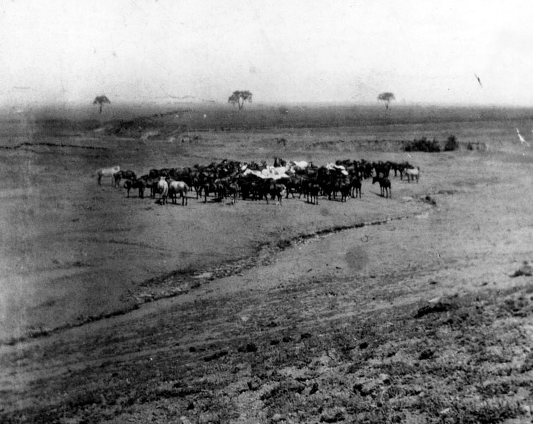
| (1900)* - A herd of horses graze freely on land belonging to Rancho Los Encino. |
 |
|
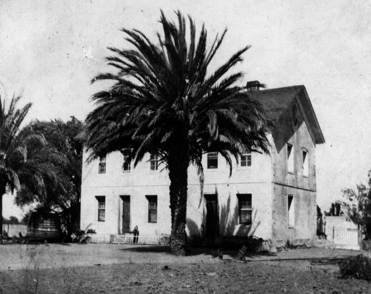
| (1900)* - Exterior view of Rancho Encino's Garnier House, built in 1872 by French Basque sheepman, Eugene Garnier. The home is a replica of his French home. |
Historical Notes In 1889 Domingo Amestoy acquired all 4,500 acres of Rancho Los Encinos. After his death in 1892, his sons, John and Peter Amestoy, assumed ranch operations and changed the name to Amestoy Ranch. Like other ranches in the San Fernando Valley at the time, the Amestoys cultivated wheat and barley. The Amestoy family held title to rancho for fifty-five years. Prior to purchasing the Rancho Los Encinos, Domingo Amestoy was a successful banker and one of the original founders to provide the financing for the Farmers and Merchants Bank in Los Angeles in 1871.*^ Amestoy Avenue in the San Fernando Valley was named in honor of Domingo Amestoy. Louise Avenue was named after Louise Amestoy, a daughter of Domningo and Marie Amestoy.*^*^* Click HERE to see more SFV Street Name Origins. |
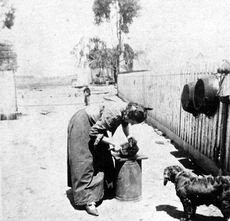 |
(ca. 1906)#^*^ - Margarite Larre Amestoy (Mrs. Peter Amestoy) working on Rancho Los Encinos (aka Amestoy Ranch). |
|
 |
|
| (1906)* - Two Native American workers sit in a horse-drawn carriage on Rancho Encino, the Amestoy family property located on Ventura Boulevard, in Encino. From L-R: Sanese and Napoleon. |
 |
|
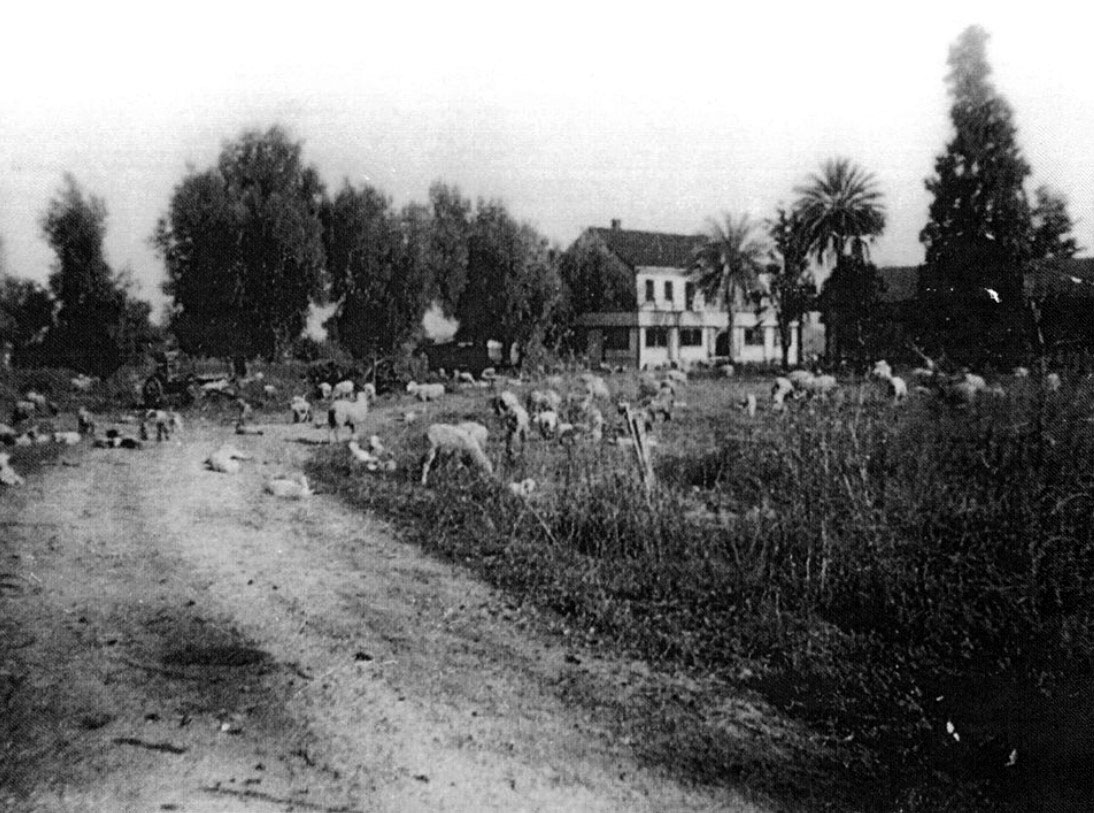
| (1920s)#^*^ - View showing sheep grazing near the Garnier House. |
Historical Notes In 1916, 1,170 acres of land was sold from Rancho Los Encinos. This parcel was subdivided and became the city of Encino.* The Amestoys held on to 100 acres, which included the old adobe until selling the property in 1944.*^ |
 |
|
| (Early 1900s)* - Chow Time on the Amestoy Ranch. A shot of the family returning from a hunting trip. The North side of the de la Ossa adobe is in the background. Note the gun being pointed at the Chinese cook. Back row, against wall: Mike Amestoy |
 |
|
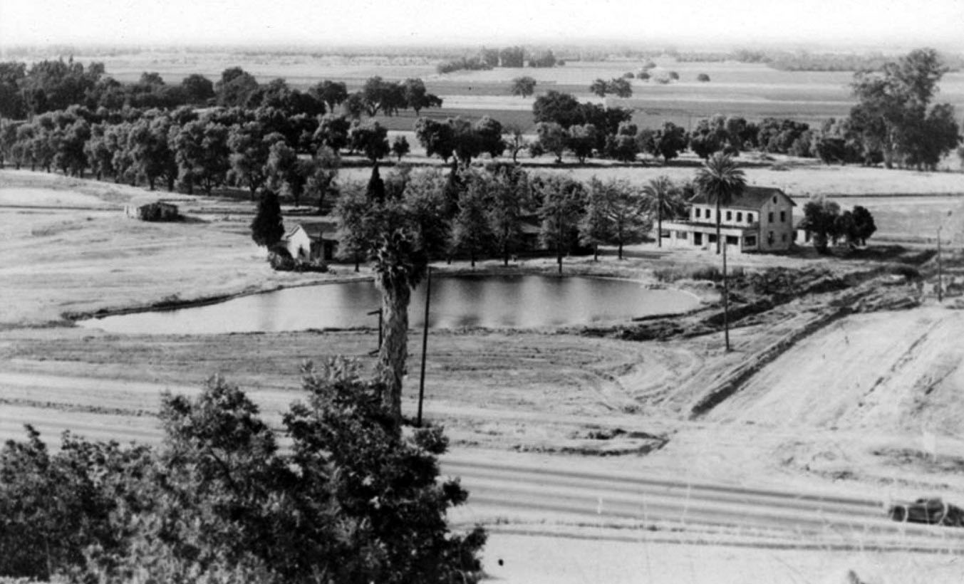
| (ca. 1940)* - View looking north showing Rancho Los Encinos. The Garnier House and original adobe sit on the other side the large stone-lined pond. Ventura Boulevard can be seen in the foreground with what looks to be an early model pickup truck at lower right. Note the vast open space in the distance. |
Historical Notes The name of the rancho comes from the original designation of the San Fernando Valley by the Portola expedition of 1769: "El Valle de Santa Catalina de Bononia de los Encinos", with "encino" being the Spanish word for oak, referring to the many oak trees in this area, to include a fair number which still exist on the site.*^*^* |
 |
|
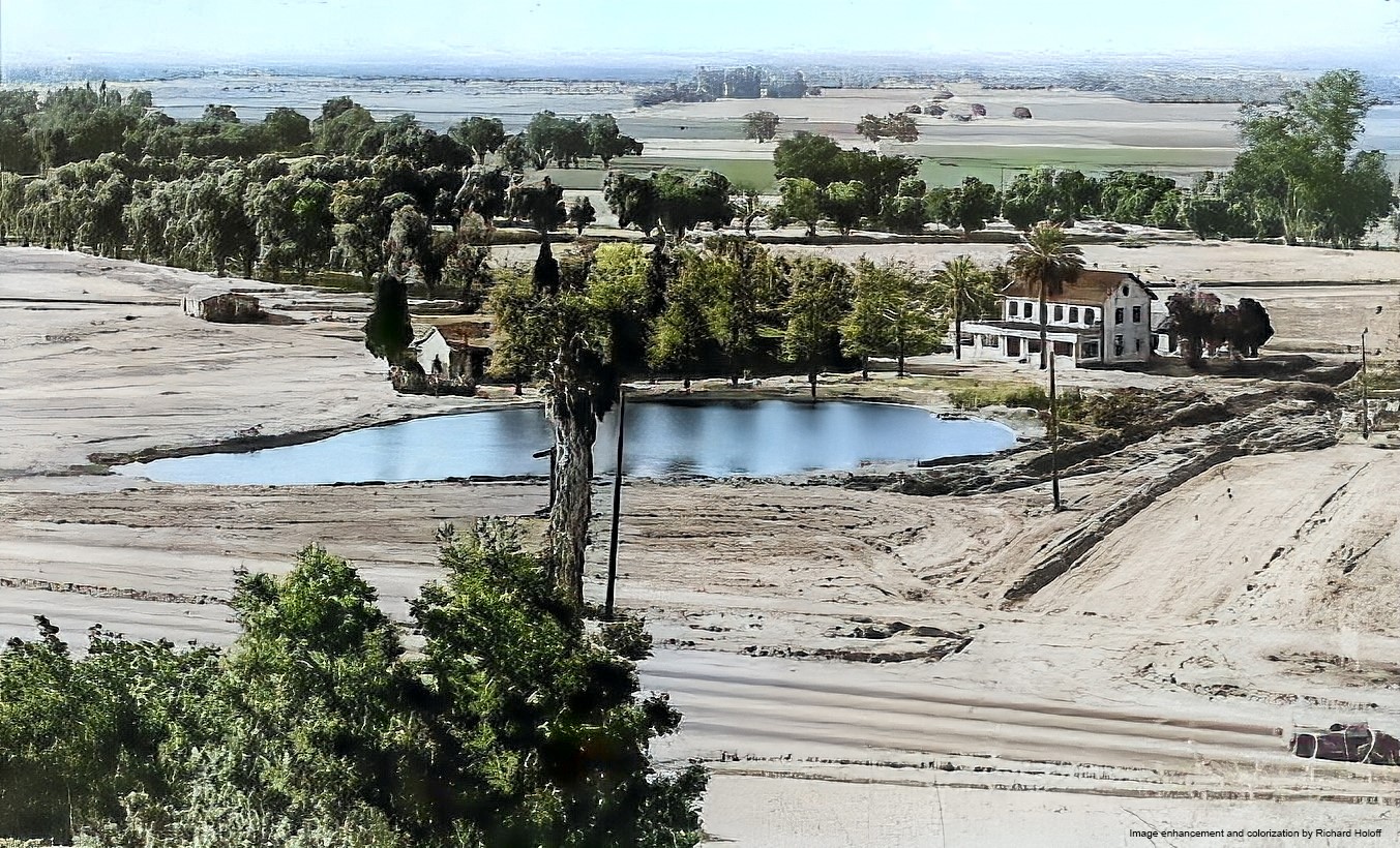
| (ca. 1940)* - View looking north showing Rancho Los Encinos. The Garnier House and original adobe sit on the other side the large stone-lined pond. Ventura Boulevard can be seen in the foreground with what looks to be an early model pickup truck at lower right. Note the vast open space in the distance. Image enhancement and colorization by Richard Holoff |
Then and Now
 |
|
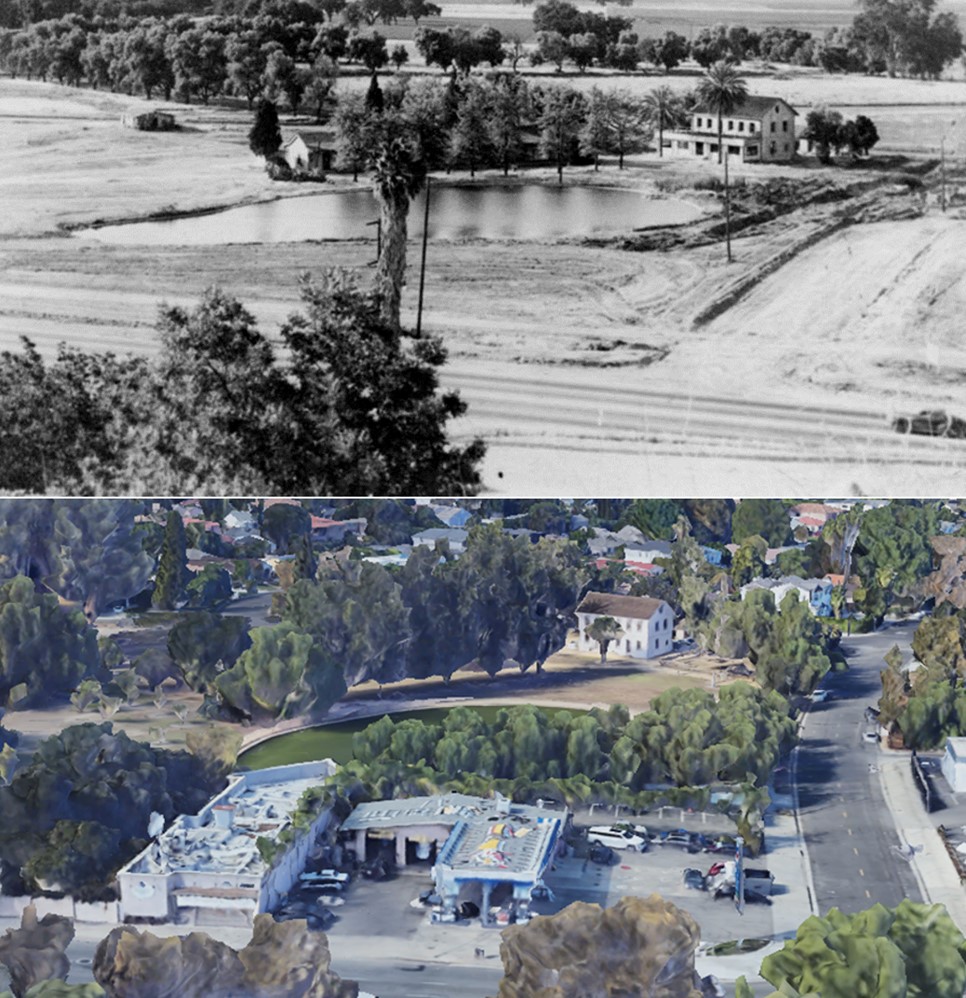
| (1940 vs 2022)* – Looking down toward the Los Encinos State Historic Park with the intersection of Ventura Boulevard and La Maida Street seen in lower right. |
 |
|
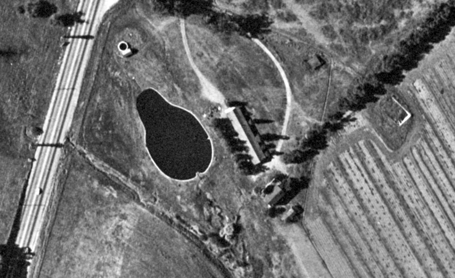
| (1944)#^*^ - Aerial view showing Rancho Los Encinos with Ventura Boulevard seen on the left. |
 |
|
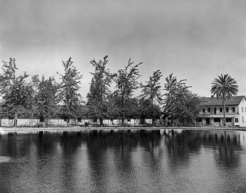
| (1949)* - View showing the old adobe ranch house at Rancho Amestoy (left), the limestone Garnier House (right), and the lake in the foreground. |
Historical Notes In 1949, through the efforts of Mary Stuart in mobilizing the local community to save the buildings from developers, the last remaining parcel of land, containing the De La Osa adobe, Garnier House and spring were purchased by the State of California, and the Los Encinos State Historic Park was created.*^*^* |
 |
|
| (1949) - View showing Rancho Los Encinos the year it became Los Encinos State Historic Park. |
Historical Notes Los Encinos State Park is listed on the National Register of Historic Places: NPS-71000142 and has also been designated as California Historical Landmark No. 689 (Click HERE to see complete listing). |
 |
|
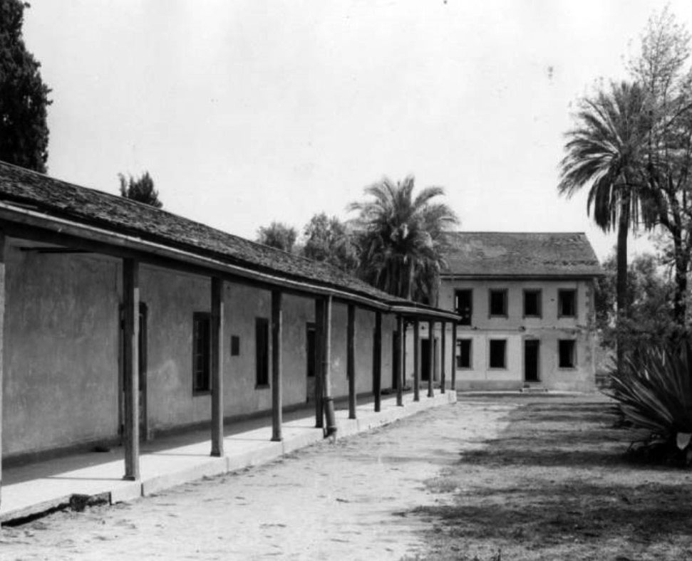
| (1957)* – Photo caption reads "Two buildings still remain. One-story structure, foreground, known as Osa Adobe, was built in 1849-1850. It serves as park ranger's office and living quarters. It used to be ranch house. In background is the Garnier Building, built in 1873, for ranch hands." |
Historical Notes Today, a Visitors' Center is located in the Garnier Building and is open for self-guided tours. The park is opened Wednesday through Sunday between 10 AM and 5 PM. Click HERE to see more. |
 |
|
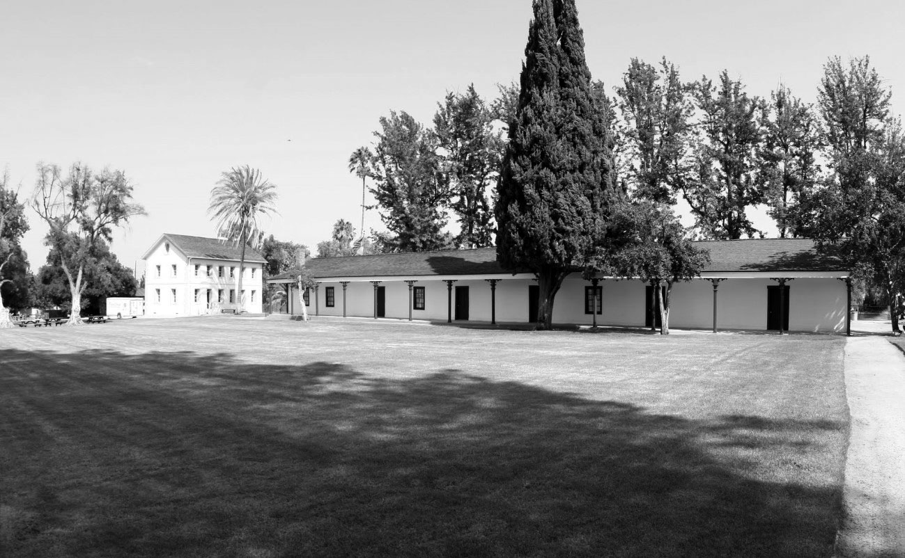
| (2014)#*^# – View of Los Encinos State Park with the Garnier Building on the left and the Rancho Encino adobe at center. The lake is on the other side of the adobe. Location: 16756 Moorpark Street, Encino. |
Historical Notes Click HERE for more contemporary views of Los Encinos State Park. |
Monte Vista Hotel
 |
|
| (ca. 1886)* - View of the Monte Vista Hotel located at present day Fenwick Street and Floralita Avenue in Sunland (then Monte Vista). |
Historical Notes Monte Vista Hotel, built in 1886, was an elegant resort that served as a weekend getaway for wealthy travelers and sportsman who hunted bear and other game in the area. The hotel had a lobby, dining room and bedrooms each adorned with a private fireplace, fancy artwork and furniture imported from around the world. A French chef served guests exquisite cuisine. An advertisement once boasted of the amenities: "The best cooking, the best furnished house, and better attention than at any hotel in the state." |
 |
|
| (ca. 1886)* - View of the Monte Vista Hotel located at present day Fenwick Street and Floralita Avenue in Sunland (then Monte Vista). Image enhancement and colorization by Richard Holoff |
 |
|
| (1910s)^.^ - A group of men stand by their early model cars in front of the Monte Vista Tavern. |
Historical Notes In later years, the Monte Vista Tavern building served as a boarding house and finally as a retirement home known as "Cypress Manor". Sadly, the home closed in 1959 and the building fell into disrepair after the owners abandoned it in 1961. By 1964 it was deemed an eyesore and demolished by the City of Los Angeles.^ |
Early Map of the San Fernando Valley
 |
|
| (1870 – 1910)^ – Early map of the San Fernando Valley showing locations of towns and ranches. |
Historical Notes The Valley was largely divided between the Lankershim ranches and the Maclay-Porter lands. Towns appeared after 1873, among them San Fernando, Burbank and Toluca. |
San Fernando
 |
|
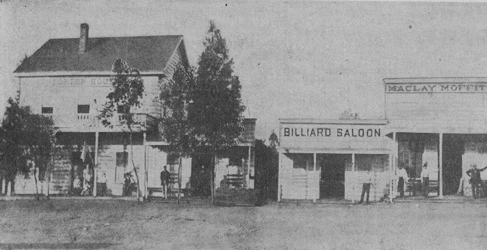
| (1882)^^# - Newspaper photo of San Fernando Road near the corner of Maclay. The Porter House was a hotel and dining establishment. Next to it was a billiard parlor and saloon, and the clapboard covered Maclay Moffitt store. |
Historical Notes In 1874, Charles Maclay bought 56,000 acres of the Rancho Ex-Mission San Fernando land grant including the northern half of the San Fernando Valley. In 1882, cousins George K. Porter and Benjamin F. Porter, owner of future Porter Ranch, each received one-third of the total land.^* A. B. Moffitt was co-partner with Charles Maclay in the store seen above. He was also the town’s coroner.*^## |
 |
|
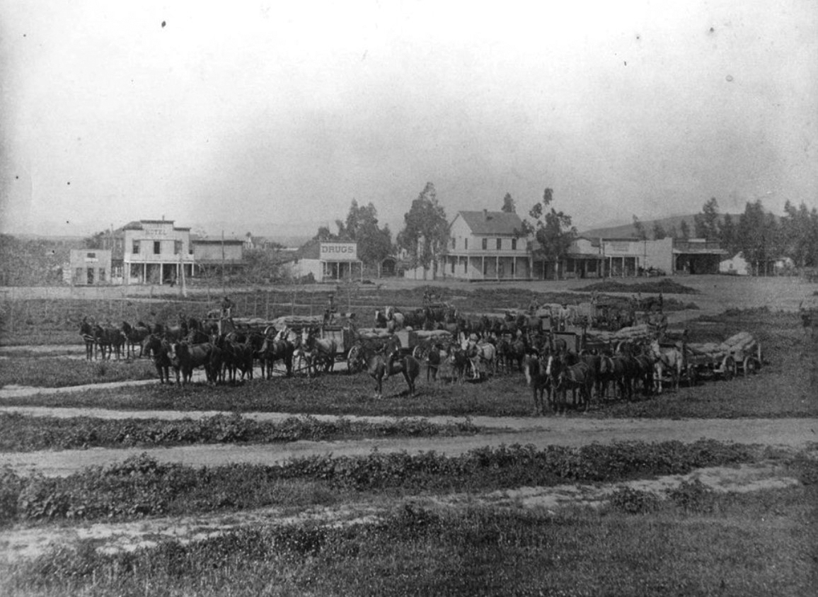
| (ca. 1880s)^^^* – View showing a horseback rider posing in front of a half dozen teams of horses pulling crop-filled wagons, with the town of San Fernando seen in the background. |
Historical Notes San Fernando, the oldest city in the valley for which it is named, is located about twenty three miles north of Los Angeles, near the foothills of the San Gabriel Mountains. Founded in 1874, it is nicknamed "The Mission City" because of its proximity to the San Fernando Mission that was established in 1797 and on whose former property the city emerged. The city's founding in 1874 was spurred by a land boom in Southern California and the Southern Pacific Railroad's building of a rail line between Bakersfield and Los Angeles through Fremont Pass. Soon populated with an influx of settlers, San Fernando became known as the railroad's "gateway to the north," and with its Mediterranean climate and deep wells that provided water for irrigation, the community cultivated an abundance of vegetables and fruits, especially citrus and olives.*#^* |
 |
|
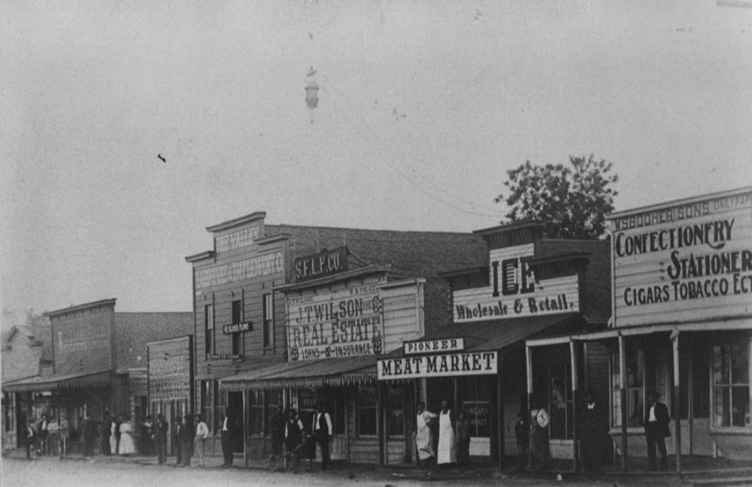
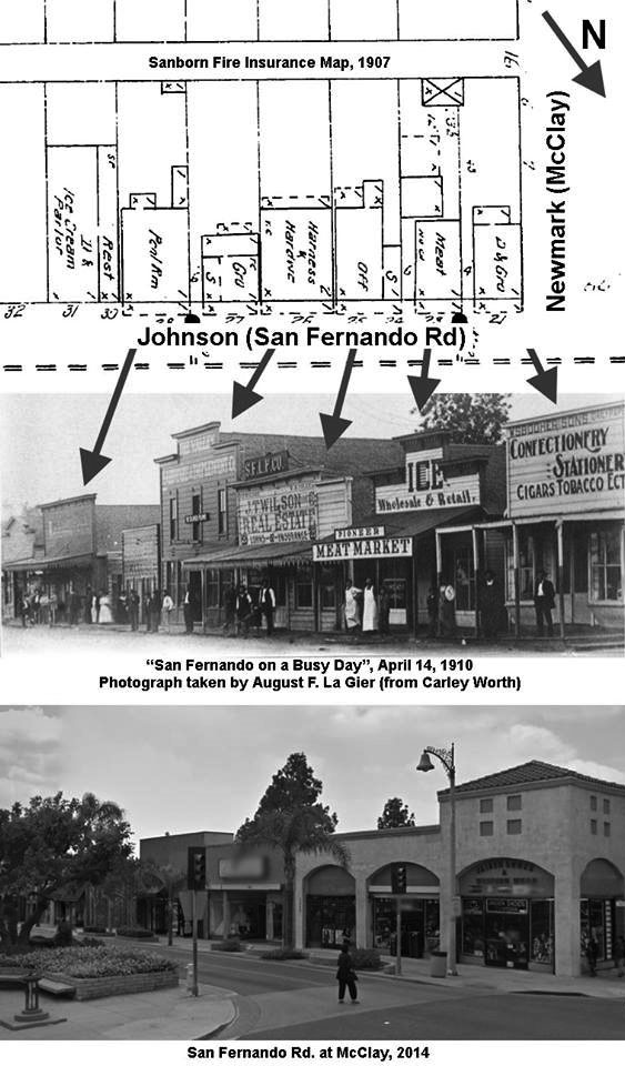
| (1910)*^^^ – Photo caption reads: “San Fernando on a busy day”. McClay at San Fernando Road, April 14, 1910. Taken by A.F. La Gier |
Historical Notes Because of its independent water supply, San Fernando remained autonomous and incorporated in 1911, while most of the valley's other communities felt compelled to annex to Los Angeles in 1915 to avail themselves of the waters of the Los Angeles Aqueduct, which started flowing in 1913.*#^* |
Then and Now
 |
|
| (1910 vs. 2014)**#^ - View showing San Fernando Road at McClay. |
Maclay School of Theology
 |
|
| (ca. 1887)* - View showing the Maclay School of Theology, a Methodist seminary founded by Charles Maclay, a Methodist minister, in 1885. He is the founder of the city of San Fernando. The school sat on ten acres on the north side of Pacoima Creek with the building designed by the prominent Los Angeles architectural firm of Kysor and Morgan. |
Historical Notes In 1885, Maclay founded the Maclay School of Theology, a Methodist seminary in his newly founded town of San Fernando. After his death it became an affiliate and moved to the campus of the University of Southern California before becoming the Claremont School of Theology in 1957. Click HERE to see Early Views of U.S.C. Charles Maclay's heritage was from Ireland and Scotland. He was the brother of Robert Samuel Maclay, a pioneer missionary to China; and the uncle of Robert Maclay Widney, a founder of the University of Southern California, and of Joseph Widney, the second president of the University of Southern California. Maclay was a Methodist minister. Charles Maclay became a California State Assemblyman in the 7th District from Santa Clara County and later a California State Senator.^* Additional Note: San Fernando Mission Boulevard was originally called Stanford Avenue, after the former Gov. Leland Stanford who loaned the money for Charles Maclay to purchase the land to found San Fernando.^* |
Porter Hotel (aka Mission Hotel)
 |
|
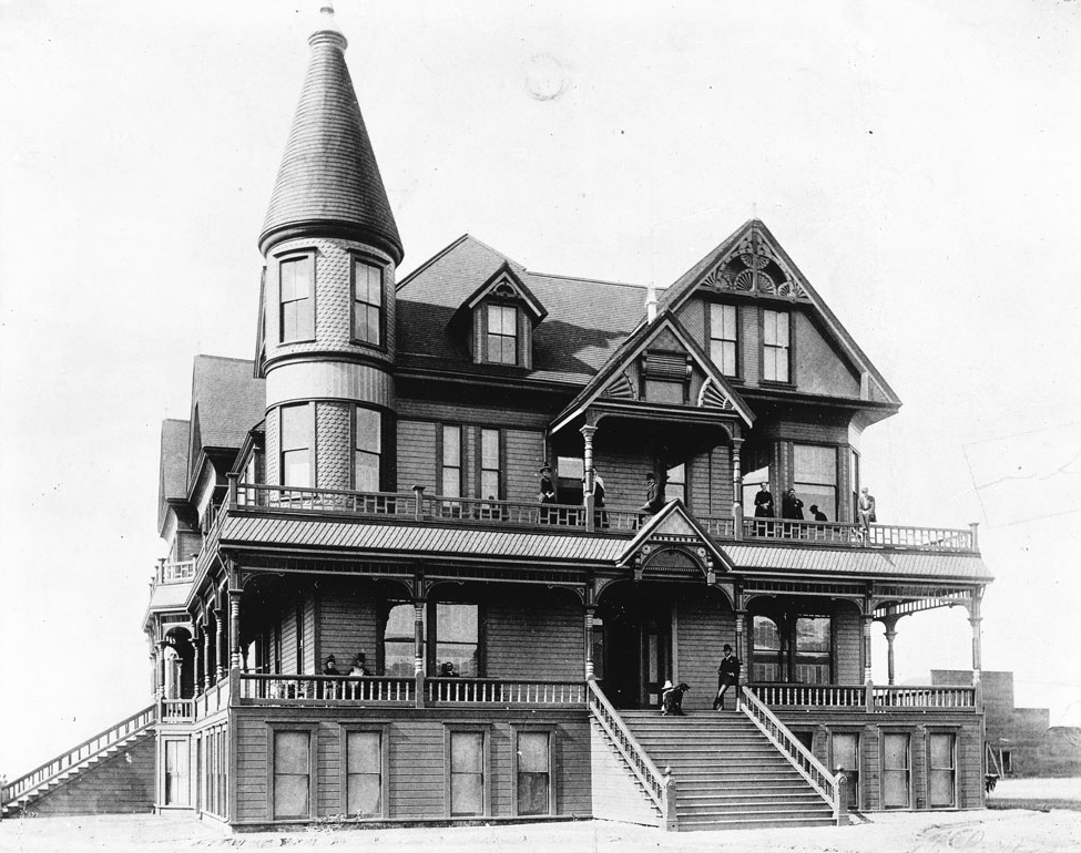
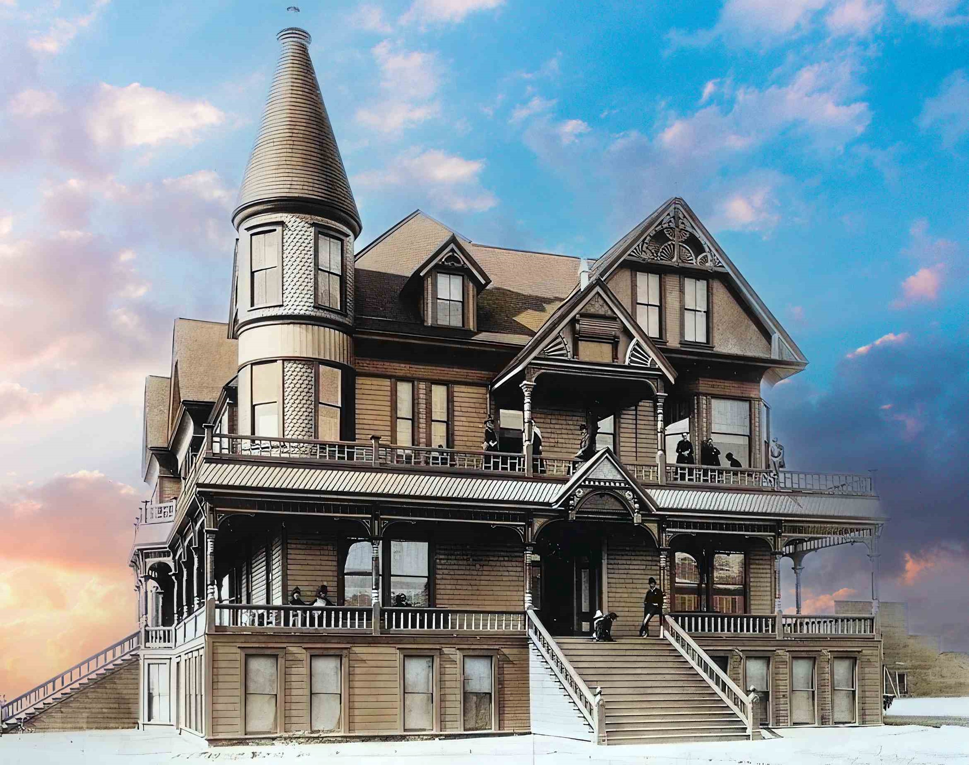
| (ca. 1888)* - The Porter Hotel (aka Mission Hotel) located in San Fernando. The three and a half-story, Victorian-style hotel is shown with people posing on its porch and balcony. On the second floor a man can be seen leaning against one of the beams which support the overhang near the hotel's entrance. A dog is visible near him at the top of the front steps that lead to the second floor and the subsequent entrance. On the second floor to the left, a two-story tower extends from the hotel, decorated in gingerbread clapboard. |
Historical Notes In the late 1800s the City of San Fernando, as well as the entire San Fernando Valley, saw a significant land boom A major hotel was built near the modern intersections of Laurel Canyon Boulevard and South Brand Street. The hotel was built in 1887 by the Porter Land and Water Company on a knoll about a mile from the center of San Fernando. It served as a hotel for about a year, and later, as a summer residence for the Porter family, 1890.* George Keating Porter came to California in the 1850s from New Hampshire and served as a state senator for Santa Cruz. Initially the Porters, George and cousin Benjamin, engaged in dry land wheat farming. In 1881, they split their holdings with a coin toss. George won and opted for the area between present-day Sepulveda Boulevard and Aliso Canyon. Benjamin F. Porter’s land became Chatsworth and Porter Ranch. George Porter subdivided his land and established the Porter Land and Water Company. In 1887, Porter developed extensive irrigation systems and began experimenting with a variety of different citrus crops. He planted an area 1 mile wide and 3 miles long, which became known as the Long Orchard.^#^ Click HERE to see more Early Views of the City of San Fernando. |
 |
|
| (ca. 1888)* - The Porter Hotel (aka Mission Hotel) located in San Fernando. The three and a half-story, Victorian-style hotel is shown with people posing on its porch and balcony. On the second floor a man can be seen leaning against one of the beams which support the overhang near the hotel's entrance. A dog is visible near him at the top of the front steps that lead to the second floor and the subsequent entrance. On the second floor to the left, a two-story tower extends from the hotel, decorated in gingerbread clapboard. Photo enhancement and colorization by Richard Holoff. |
Historical Notes The Victorian-style building served as a hotel for about a year, and later, as a summer residence for the Porter family. |
 |
|
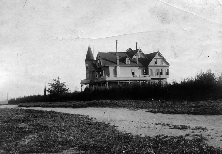
| (ca. 1890)* - Exterior view of the Porter Hotel (also called the Mission Hotel). Building was built in 1887, on a knoll about a mile from the center of San Fernando. It served as a hotel for about a year, and later, as a summer residence for the Porter family. |
Casa de Lopez (Lopez Adobe)
 |
|
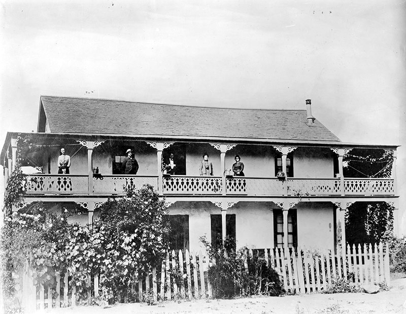
| (ca. 1883)* - View showing the Geronimo Lopez Adobe of San Fernando. Three women and two men stand on the second floor wrap-around balcony, probably members of the Lopez family. |
Historical Notes The Lopez family built the adobe between 1882 and 1883 using 24-by-6-inch, sun-baked blocks. The surviving adobe home was built by Valentin Lopez, Geronimo's cousin and brother-in-law. It was the first two-story adobe built as a residence in the San Fernando Valley. It is considered the City of San Fernando's oldest standing building.*^ |
 |
|
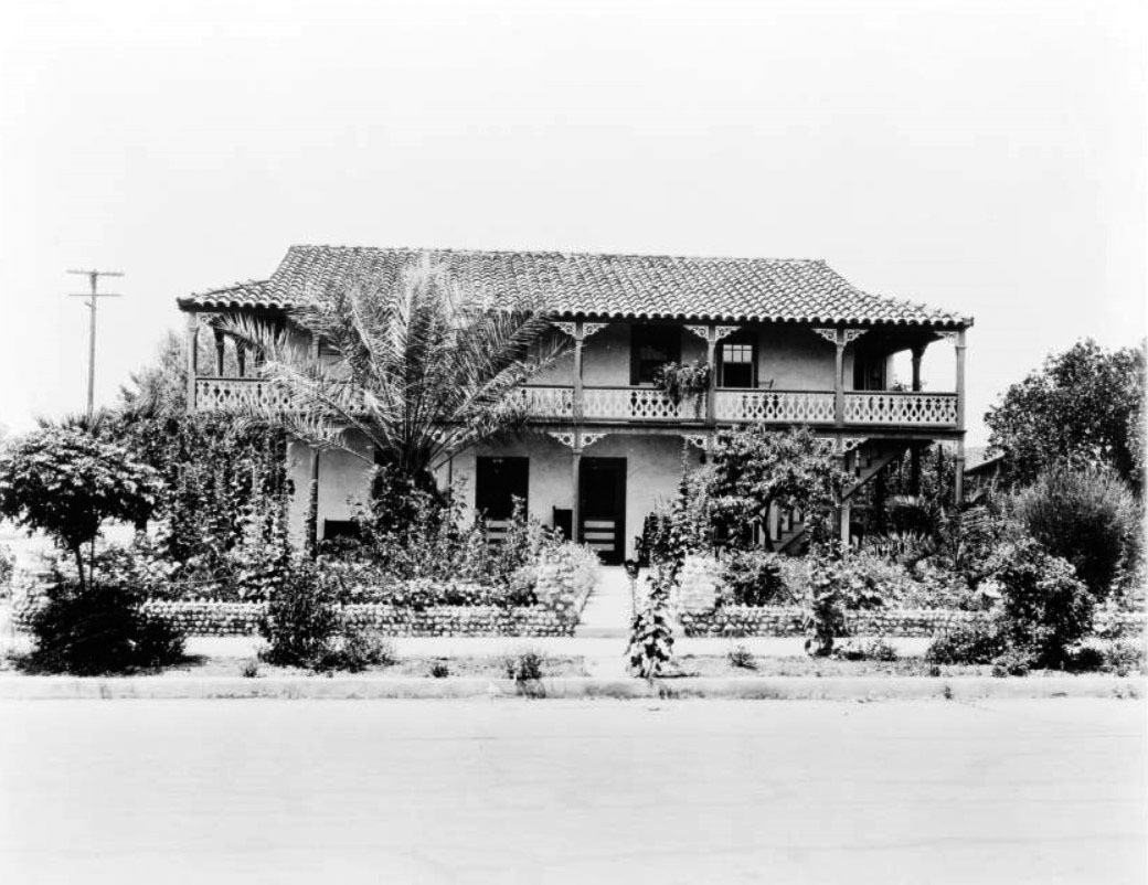
| (ca. 1925)^^ – View showing the two-story Lopez Adobe with its gilded balcony and terracotta-tiled roof, located at 1100 Pico Street in San Fernando. |
Historical Notes Catalina Lopez died in 1918, and Geronimo Lopez died in 1921, at age 90. In 1928, several modifications were made to the house by one of the Lopez daughters, Louisa Lopez McAlonan. The balcony staircase was changed, and some rooms were divided to form apartments. Modern plumbing and electrical fixtures were also added at the time. The original shake shingle roof was also replaced by clay-tile roof in 1925. *^ |
 |
|
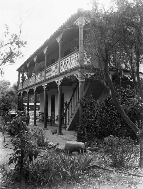
| (ca. 1935)* - Close-up view of the Geronimo Lopez adobe in San Fernando. It was built by Valentino Lopez for his father, Geronimo, in 1878. It later was used as a stage station, then was the San Fernando Valley's first post office. It is located at 1100 Pico Street, on the corner of Maclay Avenue and Pico Street. |
Historical Notes The Lopez Adobe has been recognized for its blend of Mission Revival and Victorian architectural styles. Catalina Lopez designed the residence's Victorian features. The first local newspaper, the San Fernando Times, was printed in April 1889 from the Lopez Adobe. Members of the Lopez family continued living in the adobe until 1961. The last Lopez to live in the adobe was another daughter, Kate Lopez Millen, who lived in an upper apartment from 1931 until shortly before her death in 1961. The property remained in the Lopez family until 1971. *^ |
 |
|
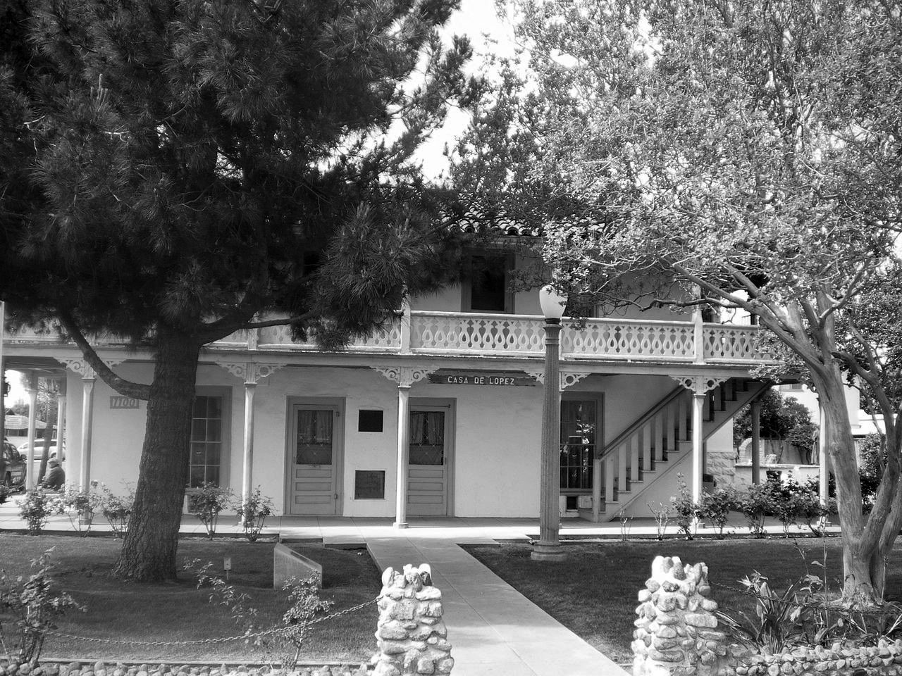
| (2008)*^ - Front view of Casa de Lopez (Lopez Adobe), 1100 Pico Street in San Fernando. |
Historical Notes Lopez Adobe is one of the two oldest private residences in the San Fernando Valley. Built by early settlers of the San Fernando Valley a short distance from the San Fernando Mission, it was listed on the National Register of Historic Places in 1971. The Grand-Reopening of the property occurred on March 22, 2015 and is now open for public tours once every 4th Sunday of the month from 12-4 P.M. *^ |
* * * * * |
Lopez Station Stagecoach Stop
 |
|
| (ca. 1885)* - View showing the Geronimo Lopez stage station and ranch adobe. A man is seen standing on the porch of the one and a half-story adobe. The roof of the adobe is shingled, and doors can be seen at regular intervals on each visible wall of the edifice. At the time the photograph was taken, the adobe was being used as a toll and stage station. It was built by Valentino Lopez. |
Historical Notes Geronimo and Catalina Lopez purchased 40 acres of land near the Mission San Fernando in 1861 and built an adobe home along the Butterfield Overland Mail 1st Division, on the Stockton - Los Angeles Road wagon route that connected Los Angeles and San Francisco. The original adobe became known as Lopez Station. The couple also operated the San Fernando Valley's first general store, its first English language school, and the first post office (in 1869) at the site. One account of the early days of the San Fernando Valley noted the significance of the Lopez family: In the late 1860s and early 1870s a traveler riding through the high wild mustard fields of the San Fernando Valley would find little evidence of people except for the mission, a few other adobes, cattle grazing in the fields and a stage house built by Geronimo Lopez and his wife, Catalina. *^ |
 |
|
| (ca. 1890)* - Lopez Station around the year 1890 was used as a stagecoach stop on the route from Los Angeles to San Francisco. It was located on the 15700 block of Rinaldi Street in Mission Hills. |
Historical Notes Lopez Station served as a stopping place for the Butterfield Stage. The station sat on 40 acres of land originally owned by Geronimo Lopez. Here Lopez established a stage stop and a general store. This valley stop would expect two stages a week from Los Angeles en route to San Francisco. Lopez Station served the Butterfield Stage Line throughout its run from 1861 until 1874. When the railroad was completed linking Northern and Southern California, stagecoach travel became obsolete. In 1868, Lopez Station also became an overnight stop for Remi Nadeau’s Cerro Gordo Freighting Company. Nadeau ran freight wagons hauled by teams of sixteen or more mules back and forth from San Pedro to the Cerro Gordo mines in the rugged Sierra Nevada Mountains in Inyo County.** The original Lopez Station adobe was destroyed in the 1910s for the construction of the San Fernando Reservoir (later renamed Van Norman Reservoir), part of the then new Los Angeles Aqueduct system. After the 1971 Sylmar earthquake the foundation was again exposed in the reservoir basin. It was later covered by the vehicle track when the Los Angeles Police Department built the Davis Training Center in the late 1990s. *^ |
* * * * * |
Beale's Cut (originally known as Fremont Pass)
.jpg) |
|
| (ca. 1875)* - Freighting strings belonging to Remi Nadeau are captured here in Soledad Canyon. Note the design of the wagons, tall and narrow. This enabled them to fit through the canyon passes such as Beale’s Cut, the only passable road cut through the San Gabriel and Santa Susana Mountain ranges. |
Historical Notes Remi Nadeau was a French Canadian pioneer who arrived in Los Angeles in 1861 driving a team of oxen. During the silver-mining excitement in the Cerro Gordo region of Inyo County his teamster operation brought tons of silver to Southern California and hauled back food and supplies to the miners. By 1873 he operated 80 such teams. He also built the Nadeau Hotel, Los Angeles's first four-story structure and the first building with an elevator.*# The Lopez Station, in present day Mission HIlls, was one of Nadeau's overnight stops. Beale's Cut is the only physical and cultural feature of its kind in the entire Los Angeles Basin. At the time of its construction in 1863, the actual creation and maintenance of the Cut was considered a significant technological and physical feat consisting of breaching the former impassable geographic barrier of the San Gabriel and Santa Susana Mountain ranges.*^* |
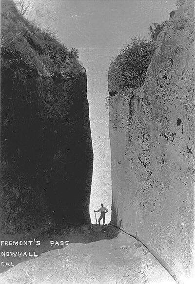 |
(late-1800s)#^*^ - View showing what appears to be a sentry standing guard at Fremont Pass (later to be known as Beale's Cut). |
Historical Notes The pass was initially named ‘Fremont Pass’ for General John C. Frémont, who was thought to have passed through it in 1847 on his way to sign the Treaty of Cahuenga, but he actually went slightly east of the pass on the El Camino Viejo. Although the pass was originally discovered in August 1769 by Spanish explorer Gaspar de Portolà, it eventually was named for Henry Newhall, a significant businessman in the area during the 19th century. In 1853, a Los Angeles businessman, Henry Clay Wiley installed a windlass atop the Fremont Pass to speed and ease the ascent and descent of the steep Santa Clara Divide. He also built a tavern, hotel and stable nearby. In 1854, Wiley sold out to Sanford and Cyrus Lyon and it began to be called Lyons Station. At the same time Phineas Banning obtained the business of supplying Fort Tejon. The steep pass was made easier to cross with a deep slot-like road cut by Charles H. Brindley, Andrés Pico, and James R. Vineyard, to whom the State of California awarded a twenty-year contract to maintain the turnpike and collect tolls. Thus, the “San Fernando Mountain,” the most daunting obstacle along the Fort Tejon Road, the main inland route from Los Angeles to the north, was cut through. Butterfield Overland Mail, a stagecoach that operated mail between St. Louis, Missouri and San Francisco began using it directly. In 1861, a landowner and surveyor named Edward Beale was appointed by President Abraham Lincoln as the federal Surveyor General of California and Nevada. Beale challenged General Pico’s loyalty to the new president and in 1863, Beale was awarded the right to collect the toll in the pass. Beale maintained rights to the cut for the next twenty years and so it became known as “Beale’s Cut.” Beale’s Cut was eventually deepened to 90 feet. It lasted as a transportation passage in the neighborhood of present-day Newhall Pass until construction of the Newhall Tunnel was completed in 1910.*^## |
 |
|
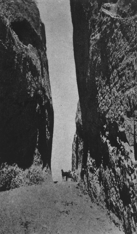
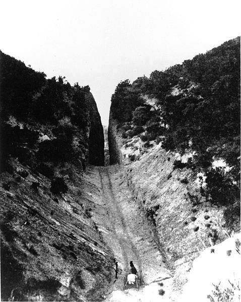
| (1870s)* - A horse and wagon is seen in Beale's Cut in the early days. |
Historical Notes In 1863 General Edward Fitzgerald Beale deepened the cut to 90 feet to get coaches and wagons through. Beale, the ex-Surveyor General of California and Nevada, was granted a franchise by the LA County Board of Supervisors to widen the extremely difficult to get through and dangerous pass known as Cuesta Vieja, or Old Grade. It was the only pass leading into the San Fernando Valley from the north. A toll service was put into effect and a small adobe house was located at the foot of the grade in which a toll keeper lived. With the coming of the railroad the beginning of the end had come for Beale's Cut. Previous to September 1876 stagecoaches from both Los Angeles and the coast had left off passengers at the summit of the San Fernando mountains near Lang's Station. They were picked up on the other side of the mountain to continue the train trip north or south. The poor old fifteen-foot wide Beale's Cut proved too narrow for "horseless carriages" by 1910 and since the freeways have come into our lives, the old cut remains almost forgotten.*^## |
 |
|
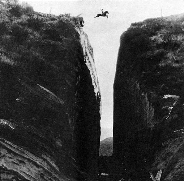
| (1923)*#^# - In this incredible photograph from 1923, silent film star Tom Mix (more likely a stunt double) jumps over Beale's Cut in the lost silent 'Three Jumps Ahead'. |
Historical Notes Beale’s Cut appeared in many silent western movies. The location became a favorite of movie producers like John Ford and D. W. Griffith. In Ford’s 1923 film Three Jumps Ahead American film actor Tom Mix is filmed jumping over the pass. John Ford used the location in at least four films over a twenty-year period beginning as early as 1917. One thing is certain about the jump over Beale's Cut: Mix didn't do it. Several movie stuntmen claim credit for the jump over Beale's Cut, but the jump in the film is most likely a composite. (In spite of the ramp at upper left, consider the proportions of the horse and rider to the actual crevice.) What is likely, however, is that a stuntman or two — including Andy Jauregui of Newhall — did make a similar jump over Beale's Cut, doubling for Mix, for three (?) trailers that were shot for various releases of the film.*^## |
 |
(n.d.)^^^* - View of a horse-drawn carriage making its way up toward Beale's cut. Note the grooves in the bedrock from all the years of traffic. Although the cut still remains, it is now only 30 feet deep, as it suffered a partial collapse.
|
 |
|
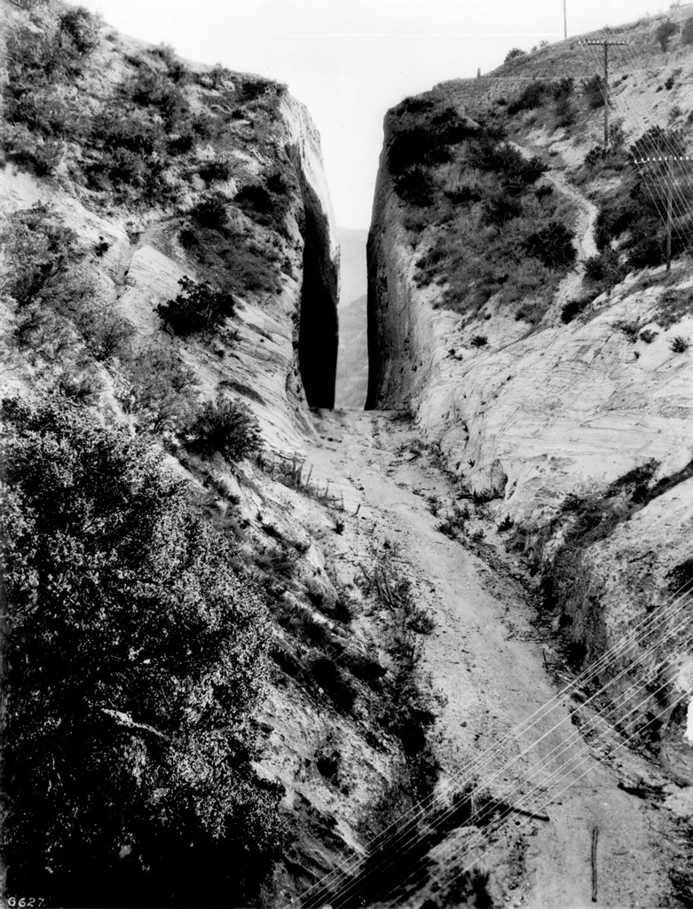
| (Early 1900s)^^ - Beale's Cut in the early 1900s. Location: Intersection of Sierra Hwy and Clampitt Rd, Santa Clarita. |
Historical Notes Beale's Cut is located in the Santa Clarita Valley in Los Angeles County and is visible from the Sierra Highway, not far from the intersection of The Old Road and Sierra Highway, just after the first bridge under the Antelope Valley Freeway (State Route 14). This slot-like roadway appeared in many silent western movies.* |
(1937)*### - Beale's Cut, adjacent to the Newhall Tunnel in northern Los Angeles County.
|
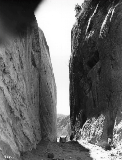 |
Historical Notes The 'Cut' was designated California Historical Landmark No. 1006. Click HERE to see more in California Historical Landmarks in L.A. |
Van Nuys Residence
 |
|
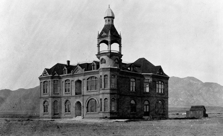
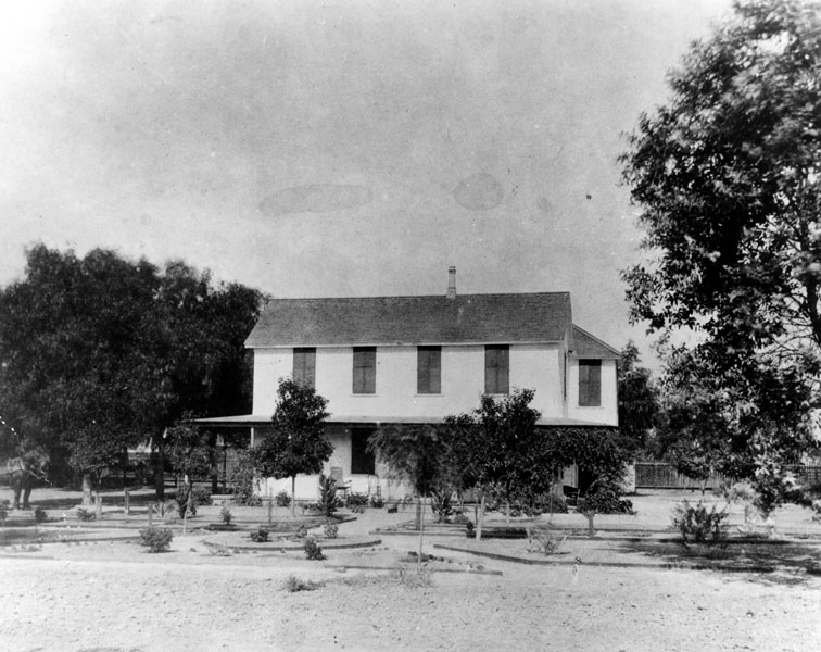
| (1882)* - Exterior view of the residence belonging to Isaac Van Nuys located in the San Fernando Valley. |
Historical Notes In 1865 at age 30, Isaac Newton Van Nuys moved to California, the first Van Nuys to actually do so. He first lived in Napa and later Monticello, where he owned a country store. In 1871, Van Nuys moved to Los Angeles, where he bought in with Isaac Lankershim's corporation, the San Fernando Homestead Association, that in 1869 had bought the southern half of Rancho Ex-Mission San Fernando totaling sixty thousand acres and engaged in the raising of stock, principally sheep. In 1873, Van Nuys, and future brother-in-law Isaac Lankershim's son, James Boon (J. B.) Lankershim, moved to the San Fernando Valley and took over management of the property. In 1874 they began raising grain, introducing dry land farming. In 1876 they filled two ships with Valley wheat at the Los Angeles Harbor in San Pedro. It was both the first grain cargo ever shipped from the L.A. Harbor, and the first grain ever shipped to Europe from the United States. As a major figure in regional history and development, there are schools, streets, libraries, and a Liberty Ship with the name of Van Nuys.*^ |
Hotel Cecil
 |
|
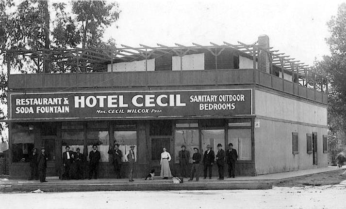
| (1888)*^^^ – View of the Hotel Cecil in Lankershim (North Hollywood). It was one of the first hotels in the San Fernando Valley. Pictured in the center is the owner, Mrs. Cecil Wilcox, with a dog by her side. A dozen men surround her, all posing for the photographer. |
Historical Notes Cecil Wilcox was the husband and his wife's given name was Clara. They appear in the censuses. He owned a furniture/book store and was apparently the publisher of a San Fernando Valley newspaper "The Lankershim Laconic." While it is not mentioned in the censuses, a newspaper article in the early 1950's promoting a "pioneer picnic" in Toluca/Lankershim, lists her as a widow who was the owner of the hotel. The photo date more than likely should be 1898 since Cecil was born in 1876. Clara (Hoegerman) and Cecil were married in 1897 in Los Angeles County. Cecil had died in 1933. Clara died in 1958. Ancestry.com has a picture of Clara and her sister Rose.*#^# |
Lankershim Elementary School
| (1888)^ - View of children and adults playing in front of the first elementary school in Lankershim (now North Hollywood). |
Historical Notes Lankershim’s first elementary school was located on Vineland Avenue, just south of Third Street (now Riverside Drive). Mary Crawford, visible in front of the doorway, was Lankershim's first elementary school teacher.^ |
 |
|
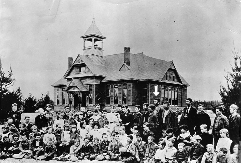
| (ca. 1889)* - Group portrait of children and adults in front of the second Lankershim Elementary School, built in 1889. Today, the elementary school is located at 5250 Bakman Avenue, North Hollywood. The arrow is pointing to Fred Weddington who graduated in the second class. |
Historical Notes Wilson Weddington opened a general store and employed his two sons, Guy and Fred. Fred Weddington was appointed the town's first deputy sheriff. He made news in 1904 by using his horse to chase down two robbers who had assaulted a man and then fled into a barley field. They were convicted and sent to prison. Fred Weddington went on to become a land developer, and he opened the town's first bank. He remained active in North Hollywood affairs until his death in 1967.^^^ |
Lankershim and Chandler
| (ca. 1891)* - This was the intersection of Lankershim and Chandler as it appeared in the late 19th Century. See what the intersection of Lankershim and Chandler looked like in: 1924 / 1946 / 2018 |
Historical Notes Lankershim Boulevard was named for the town of Lankershim (first called Toluca, now North Hollywood) and its founding family. Isaac B. Lankershim grew wheat on a wide swath of the Valley floor on his Lankershim Ranch. North Hollywood was established by the Lankershim Ranch Land and Water Company in 1887. It was first named Toluca before being renamed Lankershim in 1896 and finally North Hollywood in 1927. Chandler Boulevard was originally a leg of Sherman Way, it was renamed for land developer and Los Angeles Times publisher Harry Chandler.^* Click HERE to see more SFV Street Name Origins. |
Weddington House
 |
|
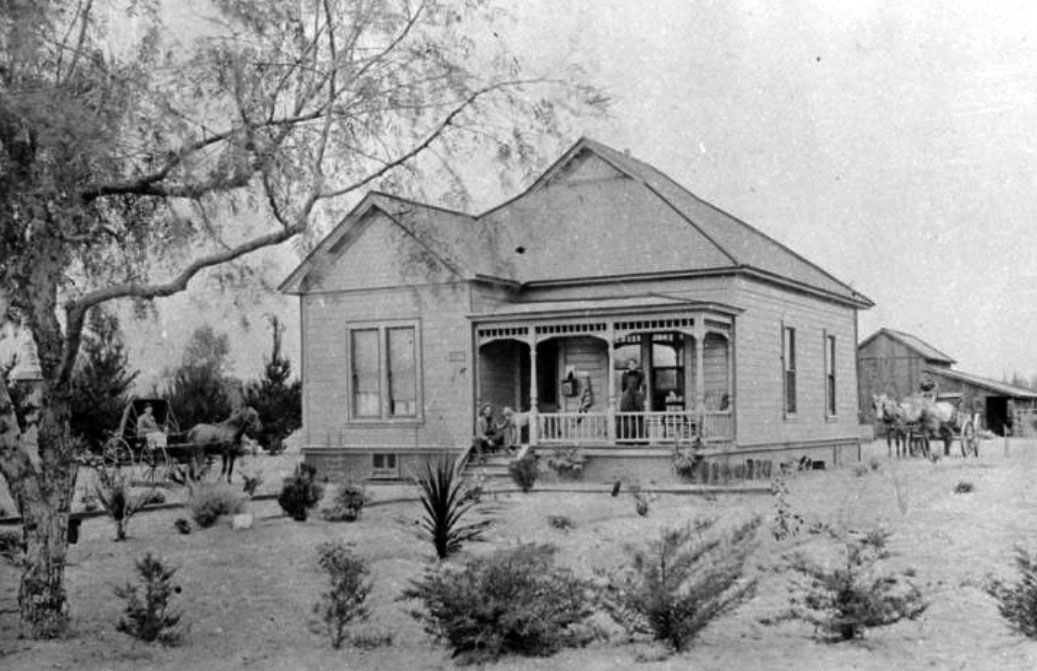
| (ca. 1895)* - View of the Weddington ranch house, now the location of the El Portal Theater, 5269 Lankershim Boulevard, North Hollywood. |
Historical Notes The above photograph was used for an article in the Valley Times dated March 4, 1949; it reads, "Tiny palm sprout in front of porch of this building, the early Weddington ranch house, grew to be large enough to be lifted out with a steam shovel for groundbreaking for the El Portal theater in 1926. This house was built in the 80's, later was post office of Toluca before town became Lankershim." * |
Pioneer Store
 |
|
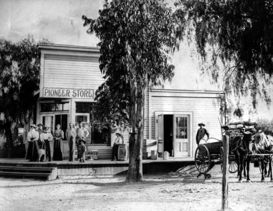
| (1897)* - Men, women, and children pose in front of the Pioneer Store located near what is now the southwest corner of Lankershim and Chandler boulevards. |
Historical Notes The above photograph was used for an article in the Valley Times dated March 4, 1949; it reads, "Taken in July, 1897, historic picture above shows The Pioneer store, part of the first business block erected in what then was Toluca, now North Hollywood, at the southwest corner of Lankershim-Chandler boulevards intersection. Store contained post office headed by Wilson C. Weddington, father of Fred Weddington." |
Lankershim Ranch
 |
|
| (ca. 1900)* - View looking down Vineland Avenue just south of Third Street (now Riverside Drive) showing the residence of William H. Andrews, located on the Lankershim Ranch. |
Historical Notes On the Van Nuys / Lankershim lands, in the late 1880’s, as wheat profits began to decline, JB Lankershim, son of Isaac, formed a group, the Lankershim Ranch Land and Water Company, and bought the easternmost 12,000 acres, and plotted the area for fruit-growing farms. William H. Andrews was the superintendent for these lands, and was the on-site director for the sale and lease of the farms for JB. As the farms grew, Andrews was instrumental in securing lands in the area for the Southern Pacific Railroad; the line that slanted across the valley to Chatsworth. #^*^ |
 |
|
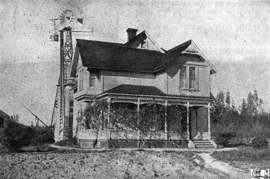
| (ca. 1900)#^*^ – Front view of William H. Andrews' House, once the only house on the Lankershim Ranch. |
Historical Notes William Andrews was married to Mary "Mollie" Weddington, the sister of Sheriff Wilson Weddington of Storm Lake Iowa. During the winter of 1890, the Andrews invited their relatives to spend the winter in warm Southern California. The Weddingtons came and saw real opportunity in the San Fernando Valley. That same winter, William Andrews conducted a land auction for the Lankershim Land and Water Company, and the Weddingtons made their first big purchase of Valley land.^^# |
 |
|
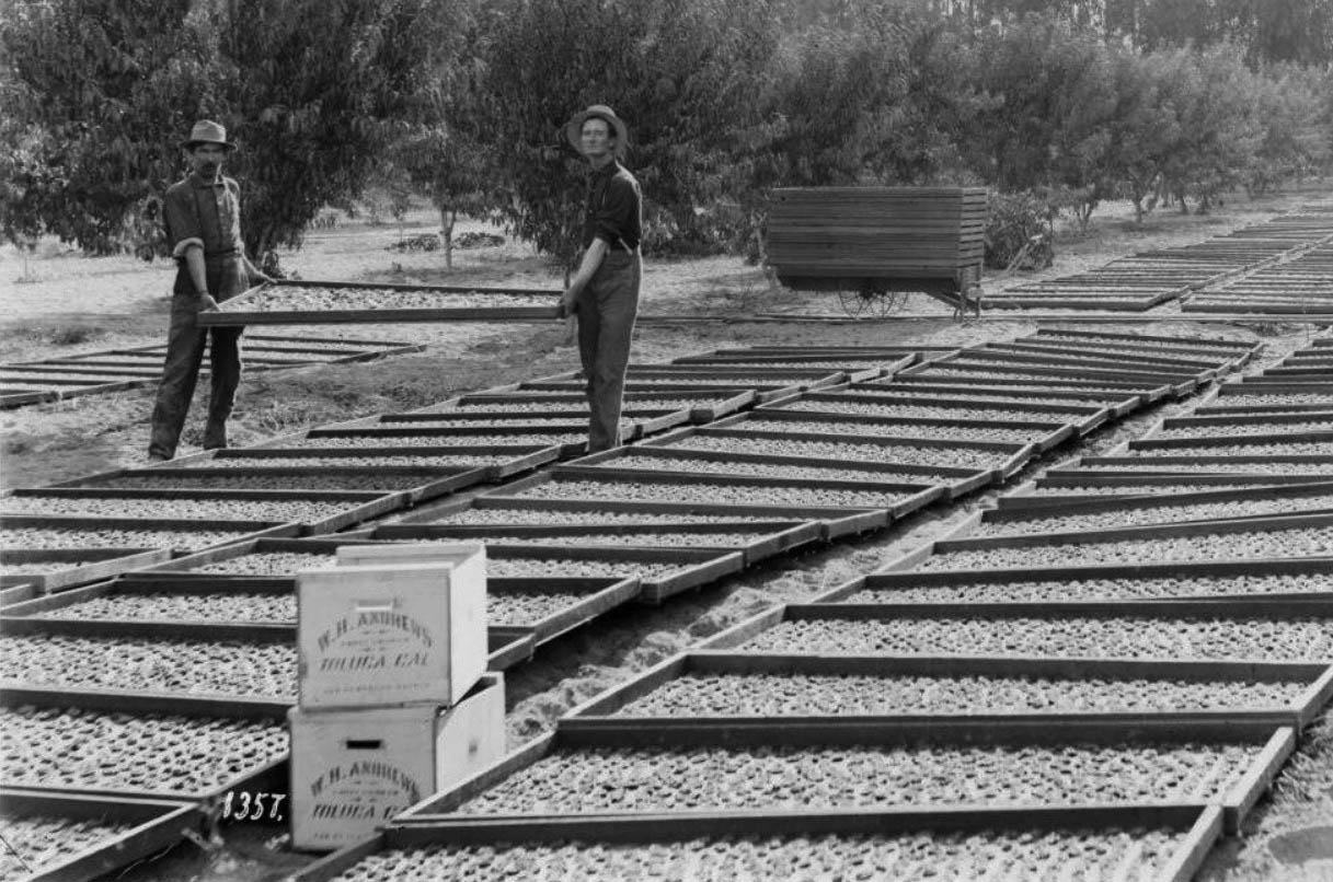
| (ca. 1900)#^*^ – Fruit processing at Andrews’ ranch. Freshly picked fruit are lined up in large wooden trays. |
Historical Notes W. H. Andrews was in charge of a labor force consisting of 120 Chinese workers. Utilizing 200 mules, they cut roads through the brush and stubble of the Lankershim Ranch. The same force was also used in laying out the new town of Burbank.^^# |
 |
|
| (ca. 1894)^ - Picnic by the Los Angeles River and Tujunga Avenue. W. H. Andrews on the left, standing. Either a Methodist Church or a family social gathering. |
Historical Notes William H. Andrews was superintendent of lands owned by the Lankershim Ranch Land and Water Company in Toluca/Lankershim. |
Chatsworth Park (later Chatsworth)
 |
|
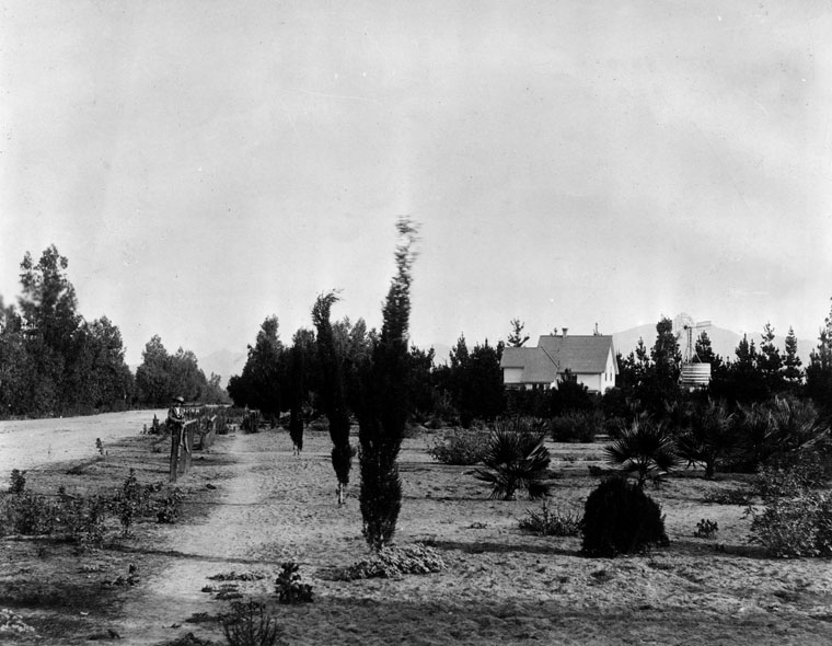
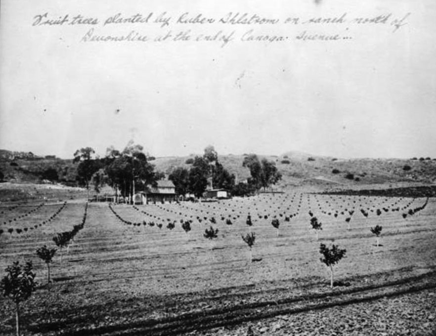
| (ca. 1890s)^ - Fruit trees planted by Ruben Ahlstrom on ranch north of Devonshire at the end of Canoga Avenue, Chatsworth Park. |
Historical Notes In 1888, George R. Crow filed a map of a subdivision called Chatsworth Park with the Los Angeles County Recorder's Office, naming it after the Duke of Devonshire's estate in England Originally planned as a farming community with land divided into ten-acre family plots, Chatsworth Park was envisioned with only three roads: Ben Porter Avenue (Chatsworth St.), Devonshire Avenue, and Fernando Avenue (Lassen). In 1872, Benjamin F. Porter sold 19,417 acres to F.C. Howes, William Booth Barber, W.F. Barber, and George R. Crow for $500,000, leading to the establishment of Chatsworth Park. By 1915, residents of Chatsworth voted to become part of Los Angeles, and in the 1920s, the area became a popular backdrop for western movies. |
 |
|
| (ca. 1890s)^^ - Photograph of Chatsworth Park and its live oak trees, San Fernando Valley. Beyond a lone oak tree in the foreground, piles of wood are stacked between two pairs of railroad tracks. Four buildings are visible in the center of the field. A newly planted orchard borders the buildings. Mountains are visible beyond the distant rocky hills. |
Historical Notes In the late 1800s the San Fernando Valley was divided into thirteen ranches, seven of which were located in the southern half of the valley and six in the northern half. The Granger Ranch, owned by Benjamin F. Porter, became Chatsworth Park. |
 |
|
| (1893)^ - View of the first Chatsworth Park railroad station (center). A water tank and train are also visible as well as the 1890--built Chatsworth Hotel (center-left). Note the beautiful oak tree in the foreground. |
Historical Notes The above photograph illustrates the abundance of valley oaks (Quercus Lobata) in the Chatsworth region before the 1920s when reliable water sources for irrigation became available. The image may also be evidence of the density of valley oak that originally covered the entire Valley.^ |
 |
|
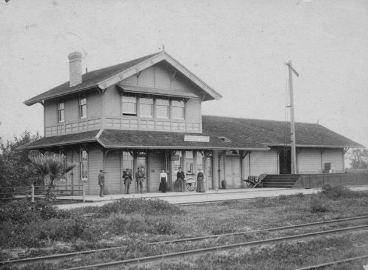
| (1893)^ - A closer look at Chatsworth's first railroad station, built 1893 and destroyed by fire in 1917. The sign on the station facing the tracks ("Trackside") reads, "Chatsworth Park, to San Francisco 494 miles" and the sign under the awning reads, "Western Union Telegraph Office." The station was located north of Marilla Ave and east of Santa Susana Avenue (later Topanga Canyon Boulevard). There were four tracks and a right-of-way between Marilla and the station. There was also a hotel (Chatsworth Hotel) located north (“Teamside”) of the station (see previous photo). Few records remain of the depot because Southern Pacific's records were destroyed in the 1906 San Francisco Earthquake. |
Historical Notes Once the railroad came to Chatsworth in 1893, the town's economy began to expand. First, the railroad gave farmers a broader market to sell their crops. Second, the construction of the Santa Susana railroad tunnel from 1898 through 1904 made Chatsworth one of the busiest places in the valley. Men came from all around the country to work on the tunnel. |
 |
|
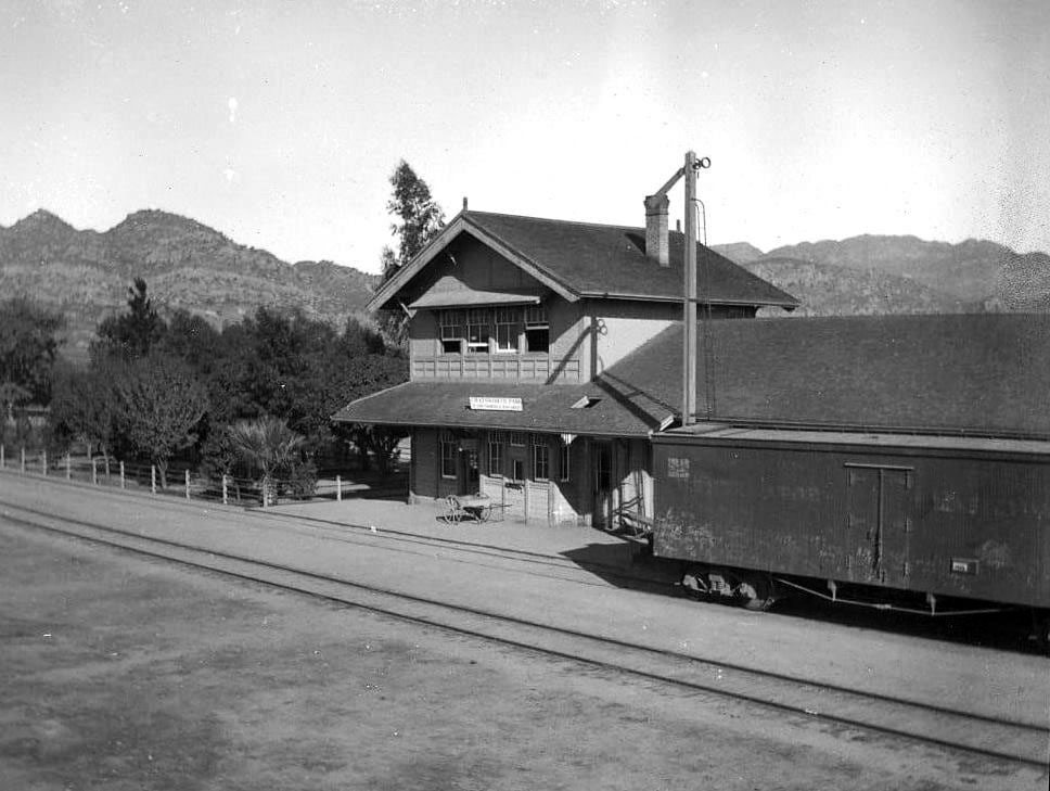
| (ca. 1906)^ – View looking NW showing the Southern Pacific Depot at Chatsworth Park with the Simi Hills seen in the background. Photo by R.A. Carpenter from the collection of his great-grandson, Rob Roche. |
Historical Notes The depot was built in 1893 and burned in 1917. |
 |
|
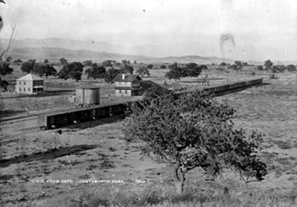
| (ca. 1890s)#^*^ – Panoramic view showing a train stopped just east of "Topanga" and north of the later Marilla. Stoney Point is seen in the background and the Train Station is at the right with the Chatsworth Hotel just behind it. The Hill/Graves store is at the left and Topanga (then Santa Susana Rd) dead ends at Marilla. |
Historical Notes In 1893 Southern Pacific Railroad completed the Burbank Branch to Chatsworth, ending along what is now Marilla and between what is now Topanga and Farralone. An additional mile of train track was also laid westward into the Chatsworth Park Quarry (Bannon Quarry) in 1898.^# |
 |
|
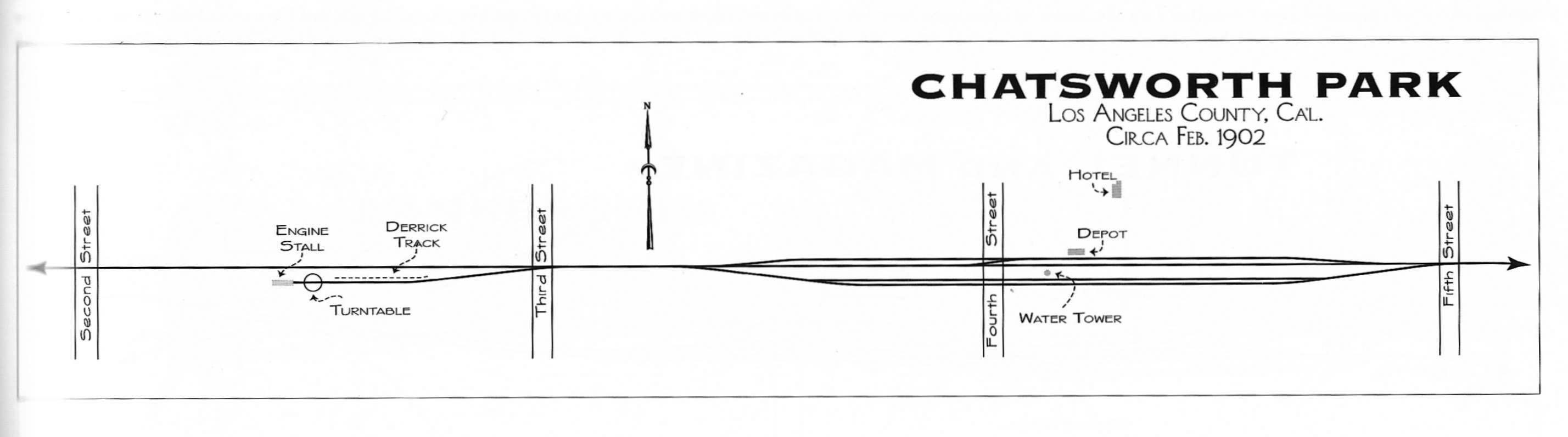
| (ca. 1902)* – Diagram showing the Chatsworth Park Depot, the Chatsworth Hotel, the turntable, and the engine shed in relation to each other. Source: "Southern Pacific in the San Fernando Valley" by David Coscia |
Historical Notes Fourth Street = present-day Topanga Cyn Blvd. Third Street = Farralone Avenue. |
 |
|
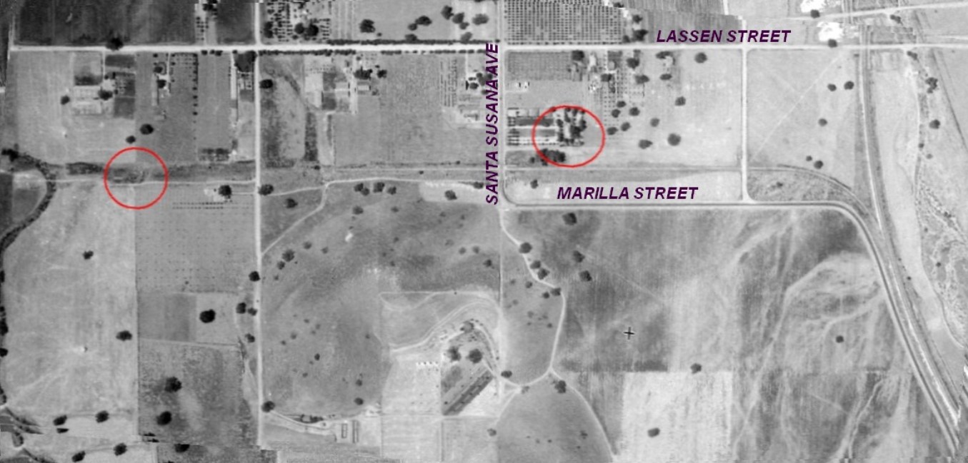
| (1930)^.^ - Aerial view showing where Marilla Street turns into Santa Susana Avenue (now Topanga Cyn). Remains of turntable is circled on the left, Chatsworth Hotel to the right. Annotations by William Flower |
Historical Notes For 11 years from the opening of the Burbank Branch Line of the SPRR in 1893 until the faster Coast Line and the tunnels were placed in service, the town of Chatsworth Park was the end of the line. Southern Pacific made heavy use of the Burbank Branch, for delivering building materials, livestock, equipment, hardware, tools, meat, produce, mail and passengers to various depots along its length. SP picked up plenty as well.. outbound produce, livestock, and passengers. There had to be a way to turn the locomotive around at the end of the line. Locomotives could move backward, but not with any speed.* |
 |
|
| (n.d.)^ - Two men are giving their all to get Southern Pacific No.22 turned around.. heave ho! Turntable similar to the one that existed in Chatsworth Park. |
Historical Notes The Bannon Quarry spur was placed in service from 1898 to 1915 to streamline the loading of up to fifty cars a day of oddly shaped "rip rap" for building the San Pedro Breakwater (1901-1905) as well as the Quarry's coveted role in providing dimensional sandstone for city buildings through 1915. Their locomotive was kept busy shuttling small numbers of flatcars up the grade to the quarry site, then down to the sidings at the Depot. Trains had to be assembled as well. This locomotive may have made use of the turntable while performing these roles. But for certain, any locomotive delivering 25 to 50 cars loaded down with rock to San Pedro would need to be at the head of the train, facing forward.* |
 |
|
| (1898)* - Cranes lift large boulders onto flatbed railroad cars at the Chatsworth Park Quarry (Bannon Quarry), located 1.5 miles northwest of the original Chatsworth Station (now Marilla and Topanga). |
Historical Notes A mile of track was laid in 1898 into Chatsworth Park, a canyon surrounded by the craggy sandstone formations of the Santa Susana Mountain Range where the Burbank branch terminated. At the right-of-way quarry above the park, sandstone formations were blasted into large boulders which would be used in the construction of the San Pedro Breakwater miles away. Derricks loaded the giant rocks carefully onto flat cars. Heavily laden trains traveled the newly built Burbank branch connecting to the main line at Burbank heading southward through Los Angeles towards San Pedro. |
 |
|
| (1904)* - Photo of workers building the breakwater in the San Pedro Harbor. Work was started in 1899. |
Historical Notes Most of the boulders used to construct the breakwater in San Pedro Harbor came from the mountains of west San Fernando Valley. Between 1898 and 1904, Southern Pacific was grading, cutting, and tunneling through the Santa Susana Mountains near Chatsworth Park as they establshed their new Coast Line connection from Ventura to Burbank. This provided San Pedro with an ample supply of boulders for their new breakwater. Click HERE to see more in Early Views of San Pedro and Wilmington. |
Chatsworth Tunnels
.jpg) |
| (1897)* - Seen in the left photo, the tunnel crew is begining the west end heading for tunnel No. 27. The right photo shows the tunnel finished and ready for the track laying gang. |
Historical Notes Construction was started for the three tunnels built for the Southern Pacific's new Montalvo Cutoff in 1898 and continued until 1904. This was to be the new Coast Line connection from Ventura to Burbank. Nearly twenty miles of new mainline trackage was also built across the San Fernando Valley between Chatsworth and the new Burbank Junction. |
 |
|
| (ca. 1898)* - Construction of Tunnel No. 26. The top half of the tunnel rock was removed first, then the lower part. Tunnel No. 26 is 1.4 miles in length (7,369 feet). |
Historical Notes Of the three tunnels (No.'s 26, 27 and 28) bored through the Santa Susana Mountains, the longest was Tunnel No. 26, being 7,369 feet in length. |
 |
|
| (ca. 1904)^^ - View of the west end of Chatsworth Park railroad tunnel. The rectangular entrance to the tunnel is at center, and a narrow railroad track leads out of it into the foreground, where it splits into two lines. |
Historical Notes The tunnels and right-of-way took five years to complete and by 1904, trains were running on the new Coast Line trackage. The San Fernando Valley stations along the Coast Line, in order, were Burbank, North Hollywood, Van Nuys, and Chatsworth. |
 |
|
| (ca. 1900)#^*^ – View looking at the Santa Susana Mountains in Chatsworth Park near Tunnel No. 27 before tracks were built. |
 |
|
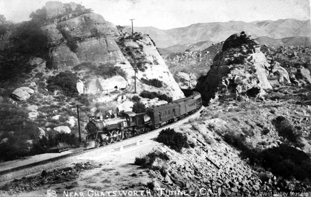
| (ca. 1914)^ - Postcard view of a Southern Pacific Train near Chatsworth Tunnel No. 27. |
Historical Notes The first car after the locomotive is a steel Railway Post Office Car carrying the mail. Steel cars were not built until circa 1910.^ |
.jpg) |
|
| (2008)^ – Interior view of the 7,369-ft long Tunnel No. 26 as seen from ground (rail) level. |
 |
|
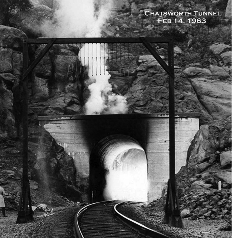
| (1963)^ - Flames and Smoke belch from Chatsworth Tunnel No. 27. Caption reads: "Fire officials say they will let the blaze burn itself out rather than send men into tunnel." |
 |
|
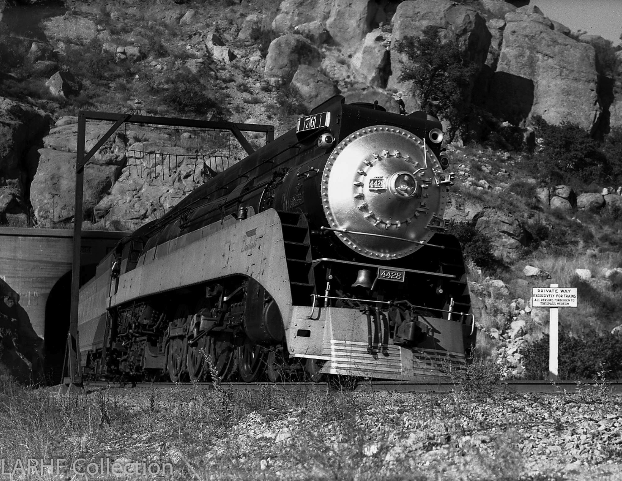
| (1948)^ - The Chatsworth Rocks in the Santa Susana Pass provide a dramatic frame for Southern Pacific's "Lark," train no. 76, as it emerges from tunnel No. 27 heading into Los Angeles in January 1948. (Photo by Frank J. Peterson / Donald Duke Collection / LARHF) |
Historical Notes No. 4428 seen above is a GS-3 type built in 1937, the first GS class with 80-inch drivers, and built to operate with a maximum speed of 106 mph. The Southern Pacific Lark was an overnight passenger train that operated between San Francisco and Los Angeles. It started its service on May 8, 1910, and became a streamliner in 1941, running until April 8, 1968. |
 |
|
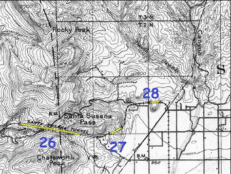
| (n.d.) – Topographical map showing locations of the three tunnels (26, 27, & 28) in Santa Susana Pass. The longest tunnel (No. 26) is 7,369 feet in length. Annotated map courtesy of William Flower |
 |
|
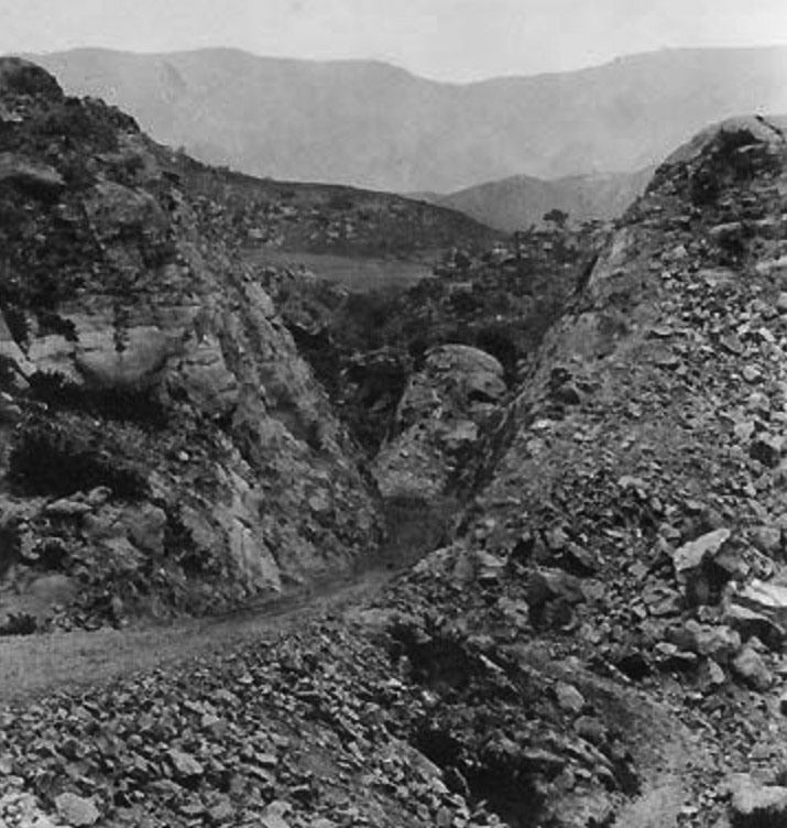
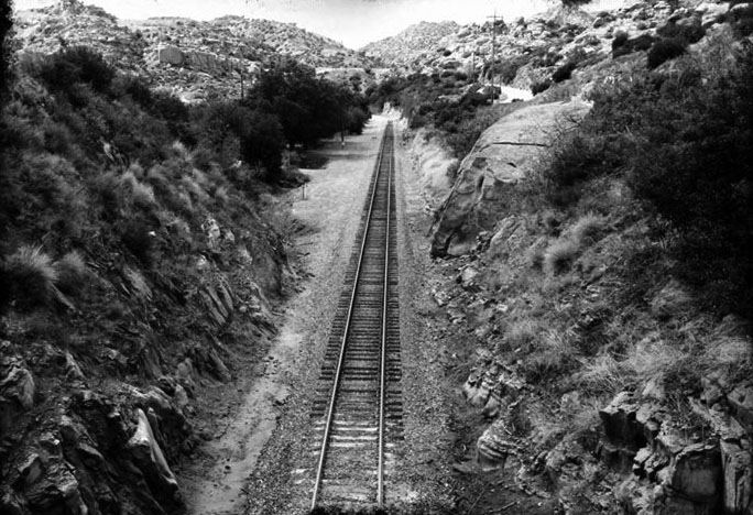
| (n.d.)^ - Heading westward from Tunnel No. 28, which passes near Stony Point. It's the only straight stretch of single track that sees daylight along this cavernous passage. |
Historical Notes As the brimming metropolis of Los Angeles continued to spill into the San Fernando Valley it created intensive building activity. Farms and ranches were giving way to homes and business. |
 |
|
| (n.d.)^ – Ground view looking down the tracks from the Simi Valley side of the Santa Susana Pass toward Chatsworth. |
Santa Susana School (later Chatsworth Park Elementary School)
 |
|
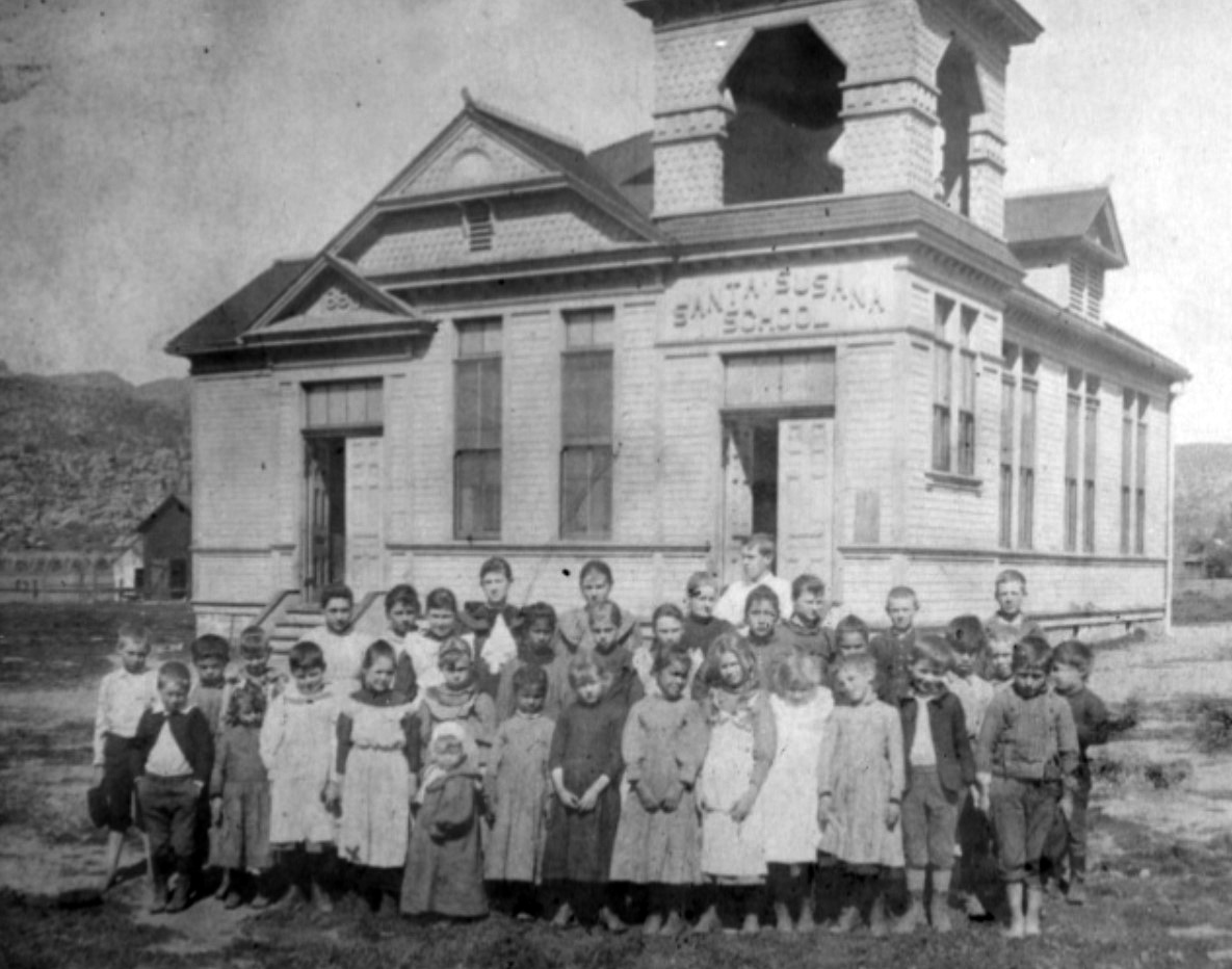
| (1902)^x^ - Group portrait of children in front of Santa Susana School (later Chatsworth Park Elementary School) located on the northwest corner of Devonshire and Topanga. The small child in the bonnet (first row) is Minnie Hill Palmer. |
Historical Notes The first school in Chatsworth Park had its early beginnings in the frontier home of Ann and Neils Johnson, who homesteaded land in the Santa Susanna Pass in 1874. At first Mrs. Johnson taught her own children at home in the evenings gathered around a kerosene lamp. As more families moved into the area, a school room was set up on a ranch located on Santa Susanna Avenue just below Chatsworth Street on the east side. In 1890, the first Chatsworth Park school building was constructed at the present site of Devonshire and Topanga. N.A. Gray donated the land on which to build the school. Chatsworth Park's first teacher was Miss Mary Gower of Hollywood and Mrs. Johnson was the clerk of the board of trustees. Mrs. Johnson's daughter, Lenora Johnson was another early teacher at the school.^ |
 |
|
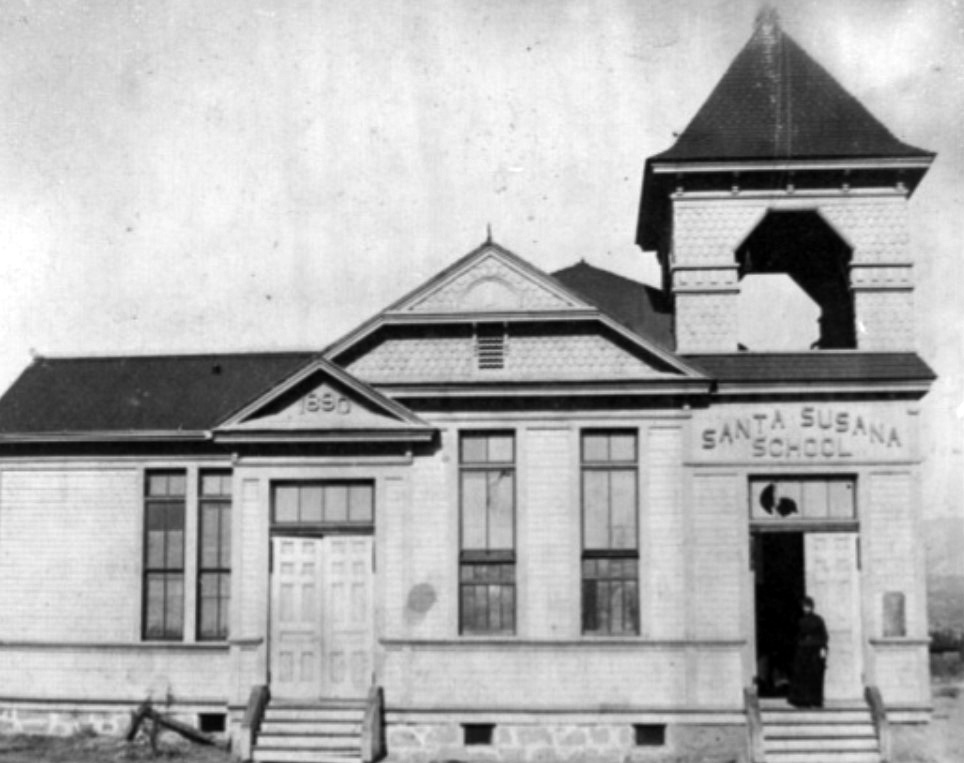
| (1890s)^x^ - Close-up front view of Santa Susana School with woman seen standing in the doorway. |
Historical Notes In the 1880's parents were reluctant to send their children to school because they needed their help working on the family ranches. There are stories of Mrs. Johnson driving around in her buggy picking up children to maintain the minimum number students needed to keep the school open.^ |
 |
|
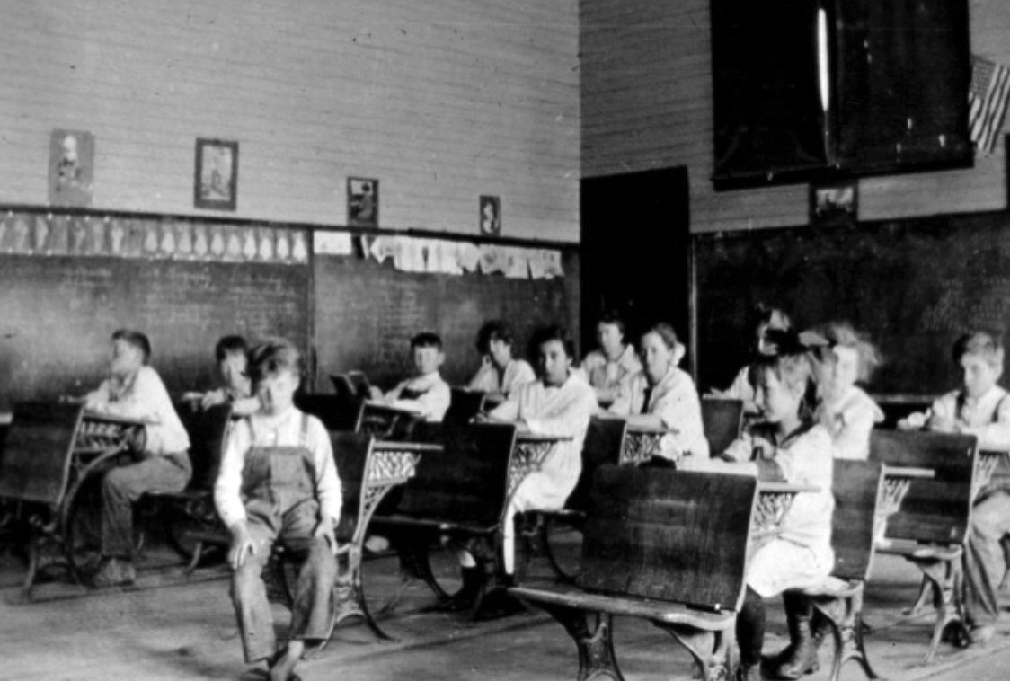
| (ca. 1900)^x^ - Interior view of the Santa Susana Schoolhouse with children sitting at their desk. |
Historical Notes In 1902, the school name was changed to Chatsworth Park Elementary School to avoid confusion with the new 1902 Santa Susana School built in Simi Valley. Click HERE to see more Early Views of Chatsworth Park Elementary School. |
* * * * * |
 |
|
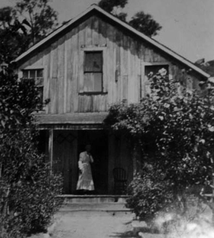
| (ca. 1900)^ – View showing Ann Johnson in front of her home in Chatsworth Park (later "Park" was dropped from the name). |
Historical Notes Verso of photograph reads: "The home she and Niels carved from the wilderness." This residence was one of the first buildings in Chatsworth, constructed circa 1870. Settlers Ann and Neils Johnson came to the area in the 1870s and carved a home from the wilderness. Mrs. Johnson became the first English-speaking woman to live in the San Fernando Valley and her daughter, Emma Johnson Graves, is said to be the first blue-eyed baby born in the Valley. Following the Johnson's, many families homesteaded on the land available outside the mission land grant, forming the beginnings of a community. ##+ |
 |
|
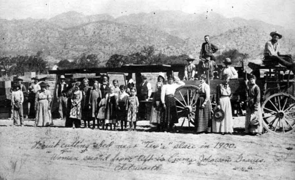
| (1900)^ - Group picture of farm workers in Chatsworth. Fruit cutting shed in rear of this portrait of farmworkers in Chatsworth, near the "Tex'a" place. The second woman on the left is Emma Johnson Graves. |
Topanga and Lassen
.jpg) |
|
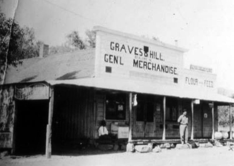
| (1911)* - Graves & Hill General Store. Lowell Hill, a part owner, is standing in front of the store. The store was located on the northwest side of the street at the intersection of Lassen Street and Topanga Canyon Boulevard. |
Historical Notes Chatsworth is one of the earliest settlements in the San Fernando Valley and has had its own United States Post Office since 1890. The above location (3rd Post Office location) was on Topanga Canyon near Lassen, about where the Country Deli is today. It was the center of town about 1900. The Graves and Hill Store owned by Jess Graves, one-time sheriff of Chatsworth, and Lovell Hill, Minnie Hill Palmer's older brother. He lived with his family on property known to Chatsworth today as The Homestead Acre at 10385 Shadow Oak Drive.^# |
 |
|
| (1910s)* - View showing two men in front of the Graves & Hill General Merchandise Store at Topanga and Lassen, Chatsworth. |
Historical Notes The Graves and Hill General Store was operating on Topanga at Lassen from 1906 to 1915. Fred Graves and Lovell Hill bought the store after he death of Mr. and Mrs. Jackson, the previous owners. Lovell Hill was the postmaster from 1912 to 1915.* |
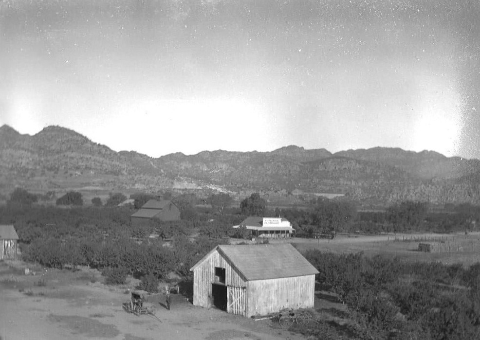 |
|
| (ca. 1910)* - View looking NW showing structures to the east of the SP Chatsworth Park depot. In the distance is the Graves & Hill General Merchandise Store at what is now near Topanga and Lassen. |
Then and Now
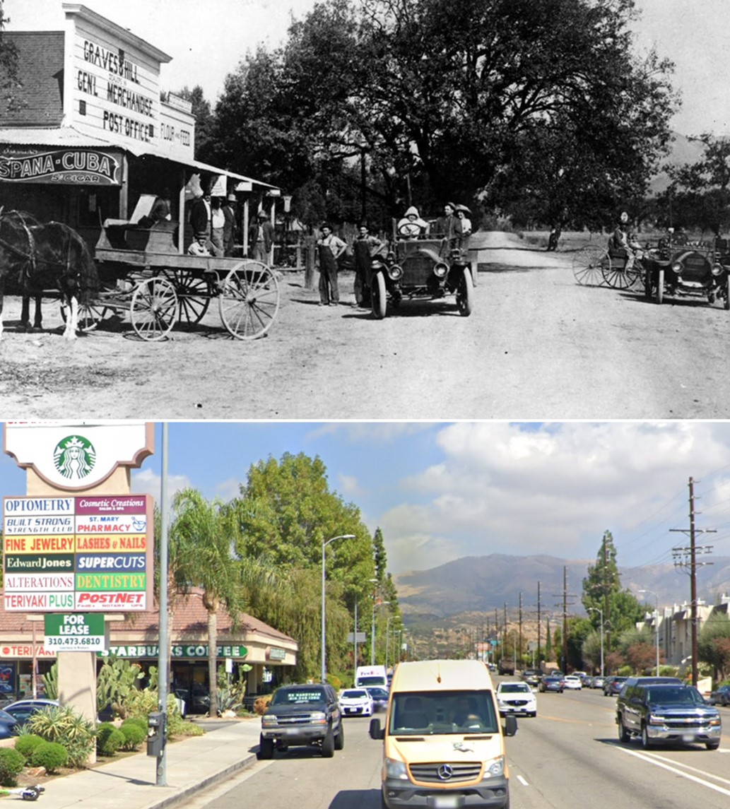 |
|
| (1911 vs 2022)* - Looking north on Topanga Cyn Blvd from near Lassen Street in Chatsworth. |
Chatsworth Hotel
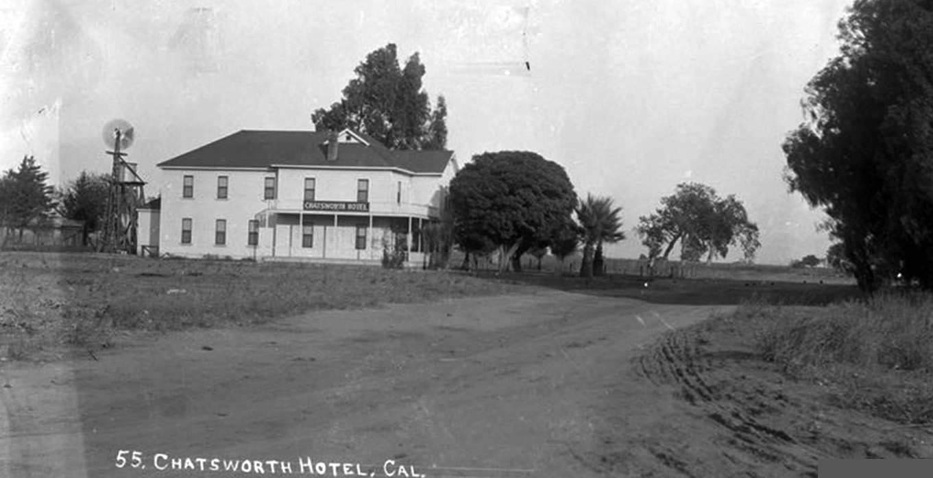 |
|
| (n.d.)^.^ - View showing a dirt road leading to the Chatsworth Hotel located just north of the Chatsworth Park Train Depot. Today this is the site of the Staybridge Suites, 21902 Lassen Street. |
Historical Notes The Chatsworth Hotel opened in 1890, and later operated as The Chatsworth Inn. A true "roadhouse" in its day, by its reputation as a "drinking club" and the only supplier of booze in a "dry town"; by its location at the crossroads of paths being forged through Chatsworth to points beyond; by its connection to the Southern Pacific Railroad and its record-breaking tunnel; and by its frequent use by the burgeoning film industry and its rising stars.* |
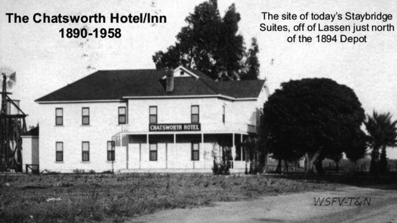 |
|
| (n.d.)^.^ - Close-up view of the Chatsworth Hotel / Inn. This is the site of today's Staybridge Suites, off of Lassen just north of the 1894 Depot. |
Historical Notes Built in 1890, the Chatsworth Inn was known for splendid meals and true western hospitality. Stars of silent picture days, railroad brass and the common man mingled here during heyday. |
 |
|
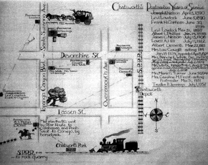
| (n.d.)^# - Photograph of a poster showing the various locations of the Chatsworth Post Office made by a former Chatsworth woman, Mrs. Elsa Braun. It was made for the opening of the Post Office when it was located on Topanga Canyon Boulevard just north of Devonshire Street in the 1950s. The poster shows the list of Postmasters and shows where the Post Office was located during their terms of office. |
Historical Notes Chatsworth is located to the southeast of the Santa Susana Pass, an extremely steep mountain pass that stagecoaches had to traverse when travelling the Overland Stage Road from Los Angeles to San Francisco. Santa Susana became a relay station for the stagecoach lines where the drivers would trade in their tired horse before attempting to cross the Overland Stage Road. Being located near a relay station made Chatsworth an important town in term of transportation history in California. As late as 1891, Chatsworth remained an active relay station for the stagecoach lines. The location of that first post office was on the stage line at the foot of the Santa Susana Mountains on the northern boundary of Oakwood Memorial Park. And it was not far from the stagecoach marker that can be seen from Chatsworth Park South today.^# |
Santa Susana Pass Wagon Road
 |
|
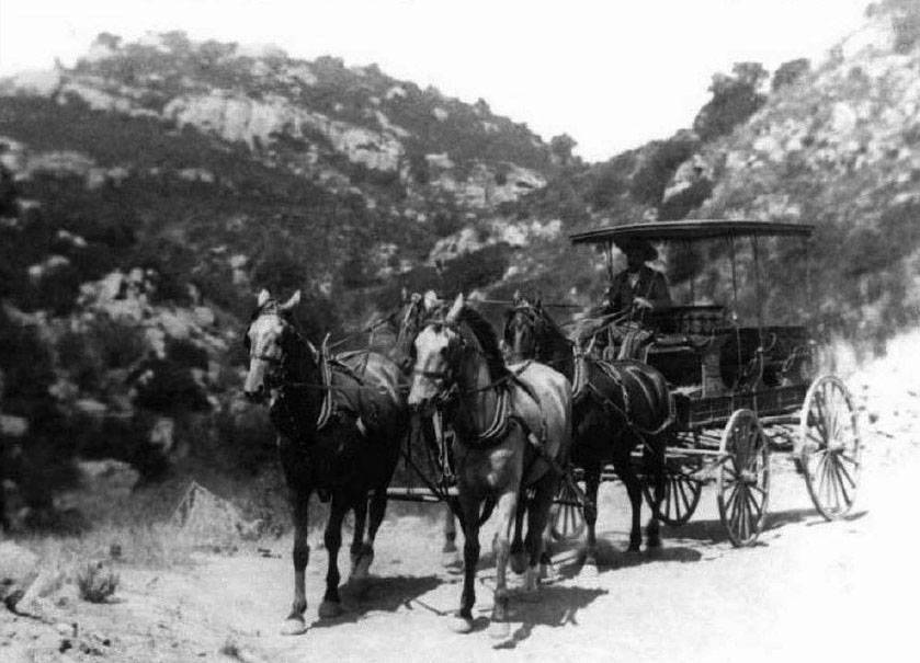
| (1890)^# – View showing Joe Horner in Stage Wagon on the Stagecoach Trail. Joe Horner ran the Simi Stage from Simi Hotel to San Fernando in 1890. |
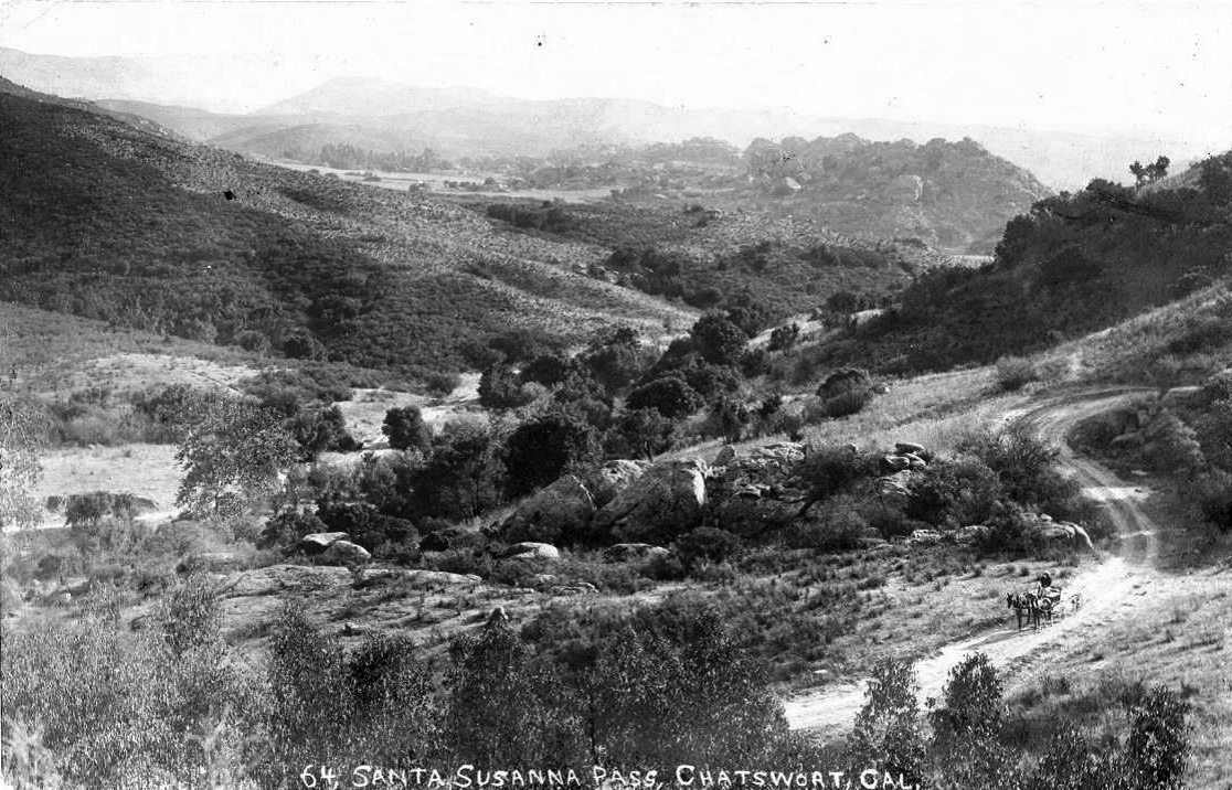
Historical Notes There have been three Santa Susana Pass Roads over the years: ◆ The first road, the “Santa Susana Pass Wagon Road”, was in use from 1859-1895. It became known as the Stagecoach Trail, and was also called “Devil’s Slide”. ◆ The second road was built north of the first road, “The New Santa Susana Pass Road through William’s Cañon”. It was a graded dirt road and in use from 1895 to 1917. It was commonly called the Chatsworth Grade Road, and is called El Camino Nuevo on the Santa Susana Pass State Historic Park maps. ◆ The third road was built just north of the second road in 1917, was paved with asphalt, and is known today as the Santa Susana Pass Road.^# |
 |
|
| (1912)^.^ - Postcard view looking east on the 1895 Chatsworth Grade Road, before the current Santa Susana Pass Road was completed in 1917. Horse-drawn wagon facing west but traveling east to Chatsworth on a switchback. Photo courtesy of the Chatsworth Historical Society |
 |
(1971)^ - Old stage coach road in Chatsworth shows the rough terrains over which the stage lines traveled. |
Historical Notes In 1859, the state put up $15,000 to fix up the Santa Susana Pass Wagon Road, under the supervision of James P. Thompson. Thompson was also the man awarded the contract to use the pass for carrying mail. The first overland stagecoach to use the pass made its run between San Francisco and Los Angeles on April 6, 1861. The trip took 72 hours. Devil’s Slide, was the portion of the trail where the grade was so steep that extra precautions were needed to prevent accidents involving runaway coaches. These precautions included tricks such as tying wheels together, using a windlass, blindfolding easily spooked horses, and cutting step grades into the stone paths. The Santa Susana Pass became the main transportation link between L.A. and San Francisco during the Civil War and remained so for about a dozen years. However, a group of new owners abandoned the stage line in 1875, although local ranchers and farmers continued to use the pass. The Chatsworth Grade Road (pretty much the 118 today), built in 1895, rendered the old Santa Susana Pass obsolete.*#^^ |
 |
|
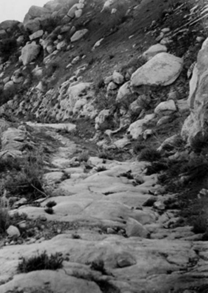
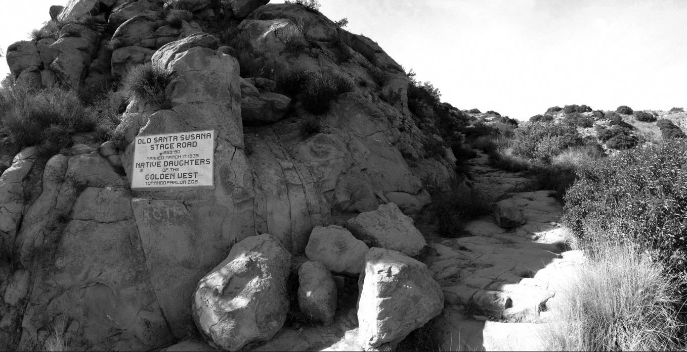
| (n.d.)#^*^ – View showing the remains of the Old Santa Susana Stage Road. Hewn out of solid rock, the route was used by the Overland Stage Company. Plaque reads: “Old Santa Susana Stage Road, 1859-90 - Marked March 17, 1939 - Native Daughters of the Golden West – Topanga Parlor” |
Historical Notes The road dates from the 1860's and represents a period in the Valley when the trail linked Los Angeles, Encino, Simi Valley, and Ventura. In 1972, the Old Stage Coach Property was designated LA Historic-Cultural Monument No. 92 (Clcik HERE to see complete listing). |
 |
|
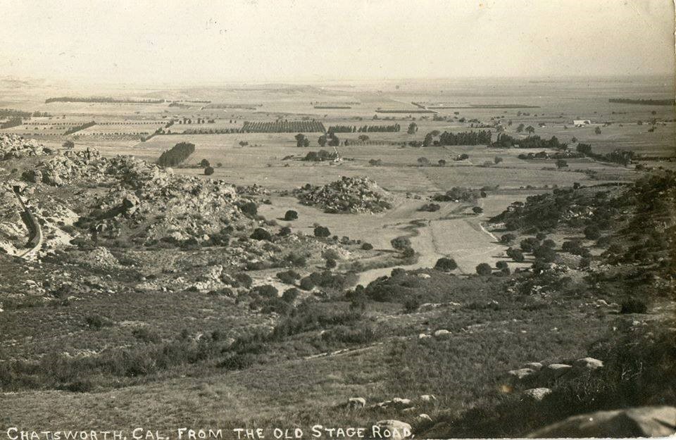
| (ca. 1910)^.^ – View of Chatsworth from the old stage road. This was well past the completion of the tunnels, but before their portals were improved. The temporary railbed leading up to Tunnel 26 has grown over. The clearing at center is present-day Chatsworth Park South. The newer rail station appears toward the upper right edge. It seems bright with new construction, and still in progress, its second story not in view. |
Then and Now
.jpg) |
|
 |
|
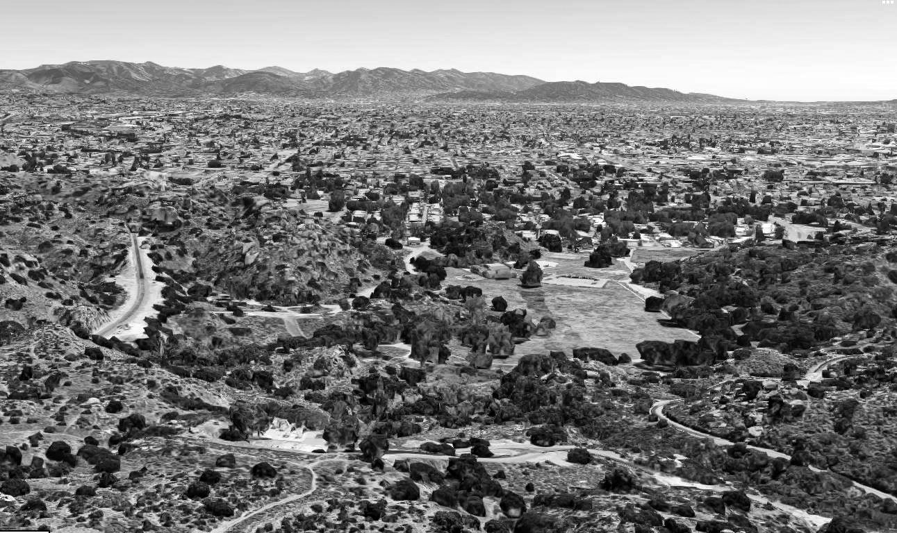
| (ca. 1910) vs (2019)^.^ |
The Homestead Acre
 |
|
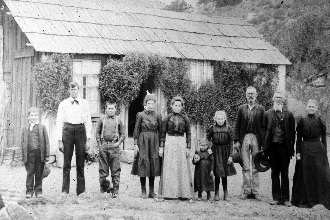
| (ca. 1900)^# – The Hill Family standing in front of the original Homestead House in Chatsworth Park South. James and Rhoda Hill are to the right. Minnie is in the center with black stockings. |
Historical Notes In the spring of 1886, James David and Rhoda Jane Hill homesteaded 110 acres in Chatsworth Park South. It is a portion of their property which is known as "The Homestead Acre" where the Chatsworth Historical Society is currently located. The Hills had eight children, two of whom were born in Chatsworth. Their seventh child, Minnie, was born in November 1886 and lived the majority of her life in Chatsworth.^ |
 |
|
| (ca. 1911)^ – View showing the Minnie Hill-Palmer Residence soon after it was built with the Susana Mountains in the background. Minnie's sisters are sitting on the porch and Lovell, Minnie's brother, is seated in an early EMF automobile. |
Historical Notes Between 1911 and 1913, the Hill family built a cottage on Homestead Acre. Minnie Hill and her husband, Alfred Palmer, lived in this house, now known as the Hill-Palmer Homestead Cottage. Minnie lived there until shortly before her death in March 1981. The Hill-Palmer Cottage is the only remaining homestead cottage in the San Fernando Valley. Surrounded by a garden and fruit trees, many of which were planted by Minnie Hill-Palmer. The Hill-Palmer Cottage was named to the National Register of Historic Places in 1979. ^ |
 |
|
| (2008)*^^# - View of the Minnie Hill Palmer Residence at 22360 Devonshire Street, built in 1911. The house was designated LA Historic-Cultural Monument No. 133 in 1974 (Click HERE to see complete listing). |
Historical Notes The Minnie Hill Palmer House, also known as The Homestead Acre, is the only remaining homestead cottage in the San Fernando Valley. The cottage is a redwood Stick-Eastlake style American Craftsman-Bungalow located on a 1.3 acres site in Chatsworth Park South, Chatsworth. The Homestead Acre and Palmer House have been preserved as they were in 1911 when the surviving cottage was built. It is owned by the City of Los Angeles Department of Recreation and Parks and maintained by the Chatsworth Historical Society as a monument. The city maintains the building's exterior, and the Chatsworth Historical Society maintains the interior. The Chatsworth Historical Society conducts tours of the cottage by appointment for groups of 10 or more and on the first Sunday of the month from 1-4 p.m. Many of the trees and flowers on the property were planted by Minnie Hill Palmer and her family. According to the Los Angeles Department of Recreation and Parks, the Palmer House has become a popular location for weddings and private parties and is also rented as a movie location.*^ |
* * * * * |
Williams Residence
 |
|
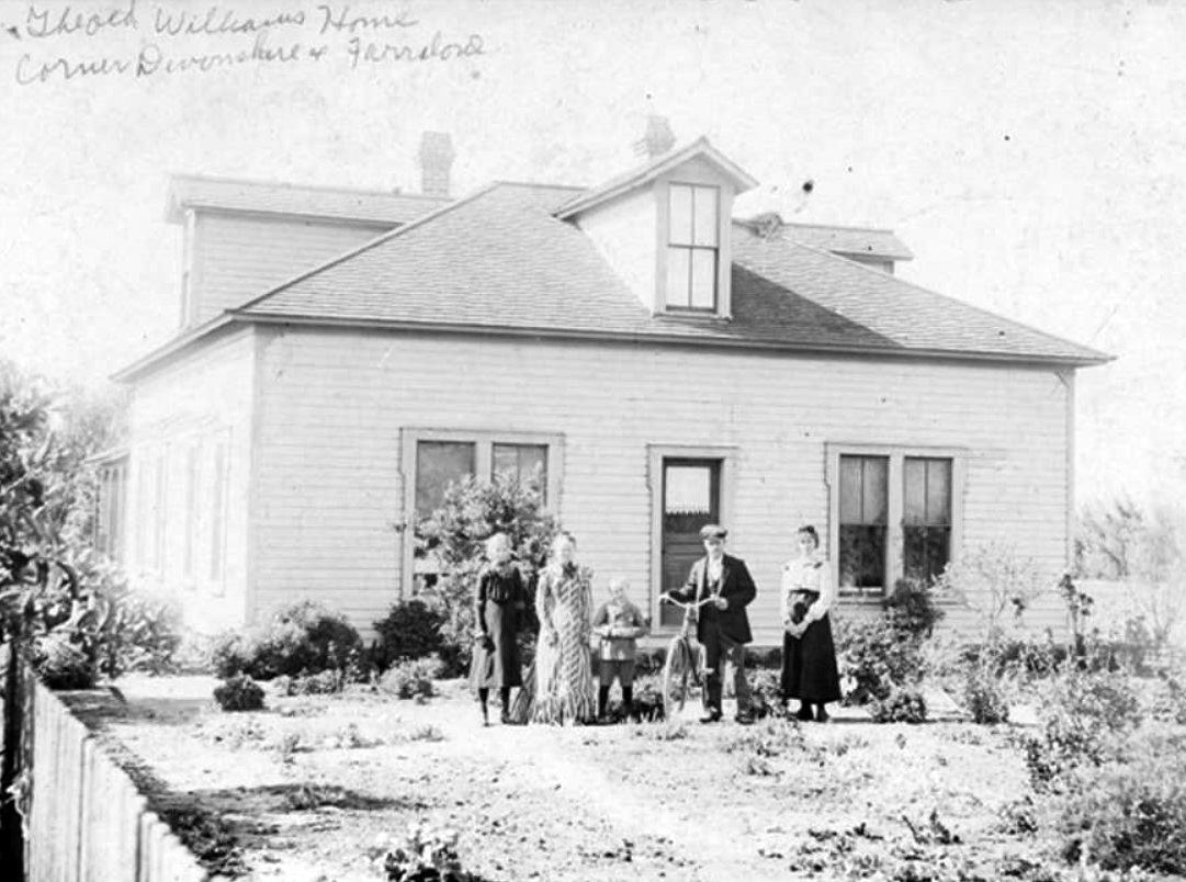
| (ca. 1900)^ - Home of the J. R. Williams Family--one of the first in Chatsworth. It was located near the southeast corner of Devonshire Street near Farralone Avenue. In 1975 it was torn down to make way for new homes. Shown here from left to right: Ida Williams, Mrs. J. R. (Carrie Vaughman) Williams, Richard Williams, E. M. (Shorty) Williams, and Mae Williams. |
* * * * * |
Please Support Our CauseWater and Power Associates, Inc. is a non-profit, public service organization dedicated to preserving historical records and photos. Your generosity allows us to continue to disseminate knowledge of the rich and diverse multicultural history of the greater Los Angeles area; to serve as a resource of historical information; and to assist in the preservation of the city's historic records.
|
More Historical Early Views
Newest Additions
Early LA Buildings and City Views
History of Water and Electricity in Los Angeles
* * * * * |
References and Credits
* LA Public Library Image Archive
^ CSUN Oviatt Library Digital Archives
#^San Fernando Valley History Digital Library - CSUN Oviatt
** DWP - LA Public Library Image Archive
^* The Valley Observied: Street Name Origins; Timeline of Valley History
^# Chatsworth Historical Society; Chatsworth History Timeline; Post Office Poster; Chatsworth Hills Homesteaders
*# Mojave Desert.net: Remi Nadeau
*^^LA Flood of 1938: Cement the River's Future (KCET)
***Los Angeles Historic - Cultural Monuments Listing
*^*California Historical Landmarks Listing (Los Angeles)
^^^LA Times: Adohr Spelled Succes for the Adamsons; Fred Weddington
^^*LA Times: Stanley Norris Petit
*##LA Times: Dig Into History You'll Find Snake Oil..Victor Girard Kleinberger
^##ReoCities: The Chatsworth Tunnels
##+Daughters of the American Revolution: Chatsworth Chapter
###Los Angeles Historical Society
#^^LA River Railroads - Burbank Branch History
#**California State Library Image Archive
#^#San Fernando Valley Blog: Van Nuys Blvd Streetcar Tracks
*#*Project Restore: Van Nuys City Hall
^*^Topanga Canyon History - LA Magazine
*#^LA World Airports - History of Van Nuys Airport
^^#The Museum of the San Fernando Valley
**#Tumblr.com: LA History - Leonis Adobe
^#*Photo of the Northeast San Fernando Valley ca.1950 - Laurie Burns
^*#North Hollywood-Toluca Lake Patch: History of the Laurel Canyon and Valley Plaza Mall; N. Hollywood Train Depot; Weddington House
*^##SCVhistory.com: Beale's Cut
*###California Department of Transportation
**^^KCET: Canoga Park at 100: A Brief History of the Birth of Owensmouth
**^#LA Times Framework: Sepulveda Tunnel
**#^San Fernando Valley Historical Society
*^^^San Fernando Valley Historical Society/Facebook.com Hotel Cecil; 1st Mail Wagon; Whitley Mansion; Van Nuys PE Depot; Toluca Flyer
^^^*San Fernando Valley Relics: Chatsworth Tracks; Beale's Cut
^*^*Metro.net: PE Line Reaches Van Nuys
^^#^Facebook.com - Great Photos from Los Angeles' Past: Van Nuys PE Railroad; Porter Ranch Farmers
*#^#Forum.skyscraperpage.com: Beale's Cut; Hotel Cecil
*#*^Openlibrary.org: Westinghouse Automatic Electric Range
*#^^Big Orange Landmarks: Old Stagecoach Trail
*#^*Los Angeles County Library: Agoura Hills; City of San Fernando
*#*#California Museum: A Journey Along the El Camino Real
#^*^Facebook.com: West San Fernando Valley Then And Now
#**#History of Funeraria del angel Praiswater
#*^#Google Maps and Street Views
#^^^City of Calabasas: cityofcalabasas.com
***^^Pacific Electric Inventory - libraryarchives.metro.net/
****^Facebook: San Fernando Valley Blog
*^*^*Los Encinos State Historic Park: historicparks.org
^^*^^Facebook.com: Garden of Allah Novels
*^^^*RareMaps.com
*^^^#DWP - Water and Power Associates Historical Archives
^***^Pacific Electric San Fernando Valley Line - ERHA.org
*^ Wikipedia: Sherman Oaks; Isaac Van Nuys; Encino; Tarzana; Campo_de_Cahuenga; Cahuenga Pass; Chatsworth; Panorama City; Santa Susana Field Laboratory; North Hollywood; Canoga Park; Woodland Hills; Reseda; Orcutt Ranch; Granada Hills; Andrés Pico; Moses Sherman; Van Nuys; Henry Kaiser; Charles Maclay; San Fernando Valley; Mission Point; Hughes Aircraft; Domonique Amestoy; Winnetka, Los Angeles; City of San Fernando; Canoga Park High School; Ventura Freeway; Hollywood Freeway; Los Angeles Valley College; Domonique Amestoy; Los Encinos State Historic Park; H.J. Whitley; Lankershim-Van Nuys Pacific Electric; Van Nuys High School
< Back