Early Los Angeles Historical Buildings (1800s)
Historical Photos of Early Los Angeles |
.jpg) |
|
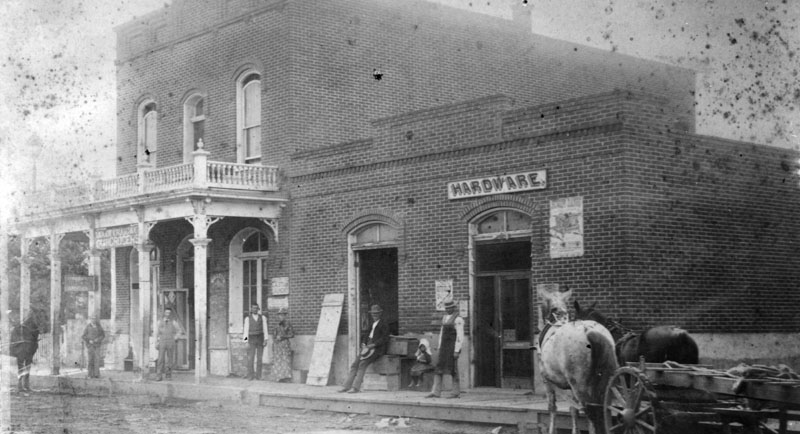
| (1886)* - Exterior view of Ralphs Bros. Grocers, located on the southwest corner of 6th and Spring Streets in 1886. A horse-and-carriage is parked in the unpaved street. |
Historical Notes This was known as "Georgetown Corner." The photo was taken shortly after this two-story brick building was built. Next door on Spring Street is the New York Bakery. George A. Ralphs is leaning on a stack of boxes, and Walter B. Ralphs is in shirt sleeves (He died in 1954 at age 99). The original address of Ralphs was 501-503 South Spring, with New York Bakery at 505. Under the new street numbering system adopted about 1890, the address for Ralphs changed to 601-603, and for the Bakery 605 South Spring. Later the Hayward Hotel was built in this location. |
* * * * * |
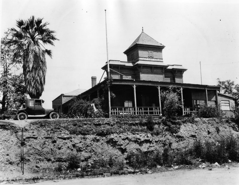
Bellevue Terrace Hotel
 |
|
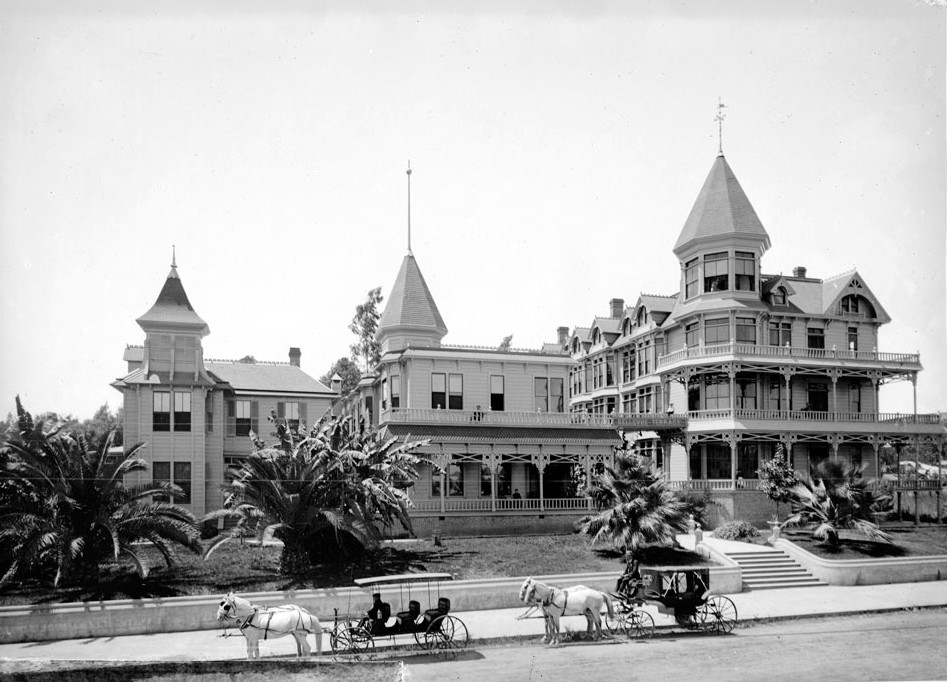
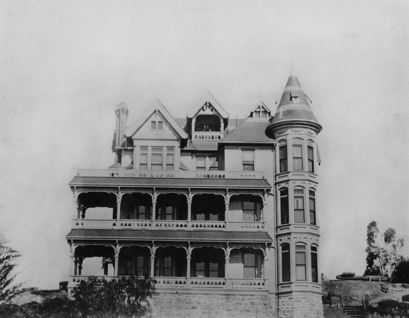
| (ca. 1890)* - Bellevue Terrace Hotel on the northwest corner of Figueroa and 6th Streets. Two horse-drawn carriages are stopped at the curb. The site is now occupied by the Jonathan Club. |
Historical Notes Built in 1884 on what was then the northwest corner of Pearl Street and Bellevue Terrace (renamed Figueroa and 6th in 1897), the Bellevue Terrace Hotel quickly became one of Los Angeles’ premier Victorian-era hotels. In 1892, Edward L. Doheny and his family stayed here; while watching fuel-laden wagons pass by, Doheny conceived the idea to drill for oil—an insight that sparked Southern California’s oil boom. The hotel remained in operation until the early 1920s, when it was demolished to make way for the Jonathan Club. |
 |
|
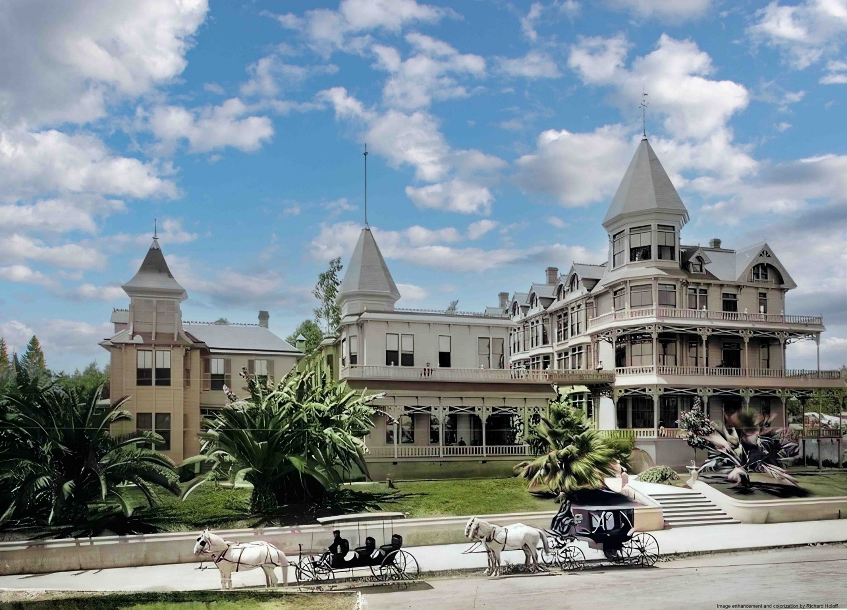
| (ca. 1890)* - Colorized view of the Bellevue Terrace Hotel at the northwest corner of Figueroa and 6th Streets. The ornate Victorian architecture, including turrets and wraparound verandas, reflected the elegance of the era. Image enhancement and colorization by Richard Holoff. |
Historical Notes Located on what was originally Pearl Street and Bellevue Terrace, the hotel catered to affluent visitors and served as a fashionable social hub in late-19th-century Los Angeles. Its prime location along a major streetcar route and its lush landscaping made it a popular subject for photographers and illustrators. |
 |
|
| (1890)* - Looking south toward the Bellevue Terrace Hotel on the northwest corner of Figueroa and 6th Streets. A boy sits on the steps leading to the entrance. Photo by C. C. Pierce. |
Historical Notes In the 1890s, this intersection was still in transition from a mixed residential-hospitality area to a fully urbanized commercial zone. The paved sidewalk along the front contrasts with the still-unpaved side street—reflecting the gradual modernization of downtown Los Angeles. At the time, the streets were known as Pearl and Bellevue Terrace. |
 |
|
| (ca. 1890)* - Bellevue Terrace Hotel on the northwest corner of Figueroa and what would later be named 6th Street. Young trees partially obscure the lower floors; the sidewalk is paved only along the front, while the side street is unpaved and lined with hitching posts. |
Historical Notes This photograph captures a moment when Los Angeles’s central district still had rural elements. The hotel’s corner location at Pearl and Bellevue Terrace (later Figueroa and 6th) gave it both prominence and easy access for travelers arriving from the west. |
 |
|
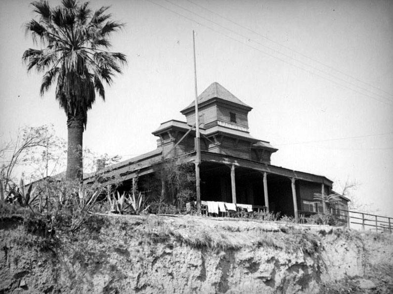
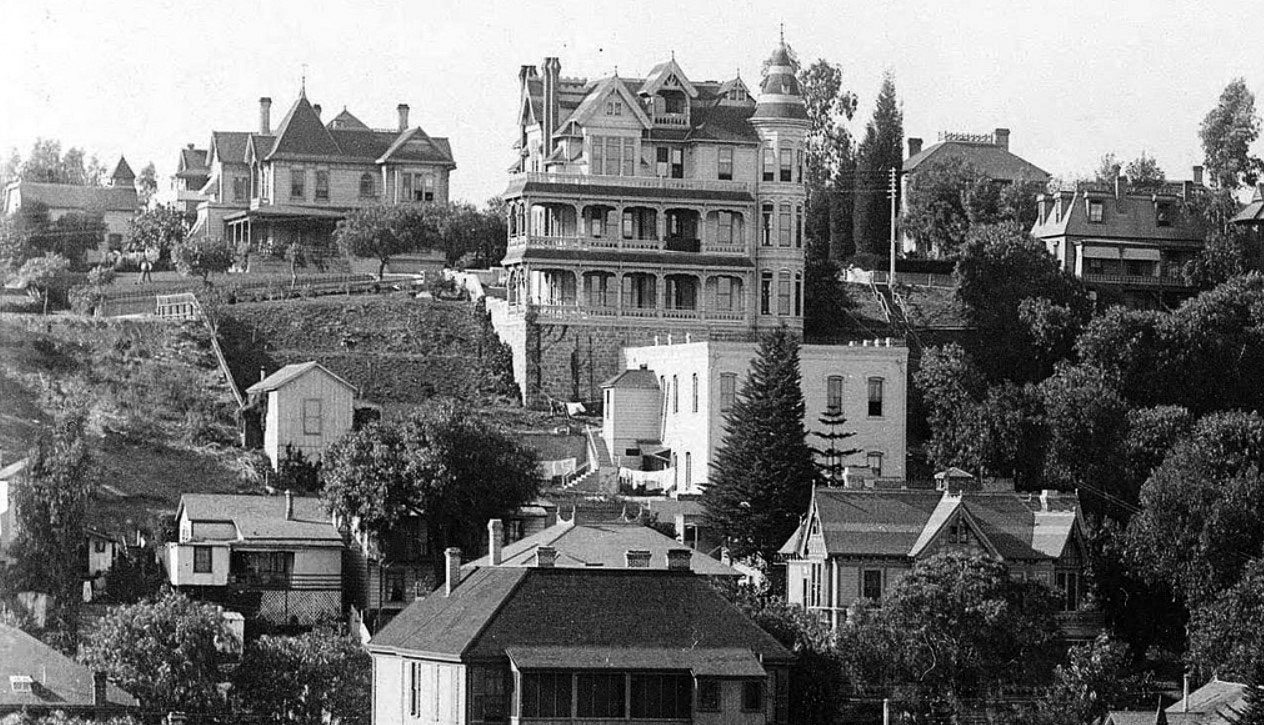
| (ca. 1916)* – Closer view of the Bellevue Terrace Hotel with 6th Street seen at lower left. |
Historical Notes In 1924, the Jonathan Club would be built on the NW corner of Figueroa and Sixth streets, where the Bellevue Terrace Hotel stood since circa 1890. |
 |
|
| (2024)* - The Jonathan Club, built in 1925, now occupies the northwest corner of Figueroa and 6th Streets, the former site of the Bellevue Terrace Hotel. |
Historical Notes Designed by Charles F. Whittlesey in the Renaissance Revival style, the Jonathan Club has served as a private social club on this site for nearly a century. It directly replaced the Bellevue Terrace Hotel, making this corner home to only two major buildings in over 140 years. |
Then and Now
 |
|
| (1890 vs. 2024)* - The northwest corner of Figueroa and 6th Streets, shown in 1890 with the Bellevue Terrace Hotel and in 2024 with the Jonathan Club. Photo comparison by Jack Feldman. |
Historical Notes From the Victorian elegance of the Bellevue Terrace Hotel to the enduring presence of the Jonathan Club, this corner’s history reflects downtown Los Angeles’s transformation—while remarkably maintaining continuous use as a prominent hospitality and social site. |
* * * * * |
Boston Dry Goods Store
 |
|
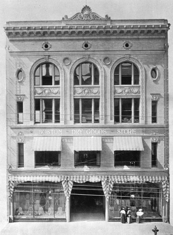
| (1880s)* - View of the front of the Boston Dry Goods Store. Three women are window-shopping in front of the large display window. The Boston Store was first started at Spring and Temple Street in 1883 by J.W. Robinson. |
Historical Notes The “Boston Dry Goods Store” began business in February of 1883 at the corner of N. Spring and Temple Streets. Joseph Winchester Robinson advertised that his establishment was characterized by “fine stocks and refined ‘Boston’ service.” The arrival of railroads spurred the enormous and long-lived growth of Southern California, and Robinson’s store brought eastern goods and their attendant sophistication to a willing (and growing) public; in 1887 the store was forced to move to larger quarters at 69-73 N. Spring Street. After returning from a trip back east in 1891, Robinson became ill and passed away in his home at the age of 45. His father, H.W. Robinson came to Los Angeles for the funeral and to look after the business founded by his late son. Remaining under family control, the store was renamed J.W. Robinson Co. (but continued to trade as the “Boston Dry Goods Store” until after the turn of the century) and moved in 1896 to 239 S. Broadway, “opposite City Hall.” In the early days of the twentieth century, the Los Angeles area grew and grew, especially with the arrival of the film industry. The store, which “catered to the most exclusive trade” according to the Los Angeles Times in 1911, expanded into adjacent properties, but it became apparent to management that the South Broadway location could not handle the store’s growth into the future. Accordingly, land was acquired along Seventh Street between Grand and Hope streets where a new store was built in 1915.^#* |
* * * * * |
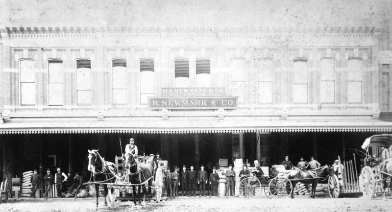
H. Newmark & Co. Building
 |
|
| (1886)* - People, horses and buggies lined up in front of H. Newmark & Co. in the Amestoy Block in 1886. |
Historical Notes Harris Newmark emigrated to the United States in 1853 from Löbau in Province of Saxony (now Saxony, in eastern Germany) and settled in Los Angeles. After working in partnership with his brother, he eventually established his own wholesale grocery business, H. Newmark and Company, in 1865, with headquarters on Spring Street. He went on to invest in real estate, holding large tracts in the San Gabriel Valley. In 1875 he sold eight thousand acres of what was then the Santa Anita Rancho to rancher E.J. “Lucky” Baldwin. In May 1899, Newmark subdivided the tract (approx. 15,000 acres) owned by himself and his nephew, after contracting with William Mulholland to design and construct a suitable water system for the new settlement. A piece of this tract adjacent to the tracks of the San Pedro, Los Angeles & Salt Lake Railroad was developed into a town site called Newmark. The remaining land was subdivided into 5-acre lots suitable for small-scale agriculture. The entire settlement, including the Newmark town site, was given the name Montebello. When the town incorporated in 1920, Montebello replaced Newmark as the new city's name. Newmark was one of the founders of the Los Angeles Public Library, was a charter member of the Los Angeles Chamber of Commerce, and was one of the organizers of the Board of Trade, which helped bring railroad service to California. He was the president of Congregation B'nai B'rith in 1887 (he inherited the title from his uncle and father-in-law Joseph Newmark) and a founder of the Jewish Orphans Home. Newmark was also instrumental in the establishment of the Southwest Museum, which is now part of the Autry National Center. He and other Newmarks were leaders of the local Odd Fellows and were Masons.^* |
* * * * * |
Nadeau Hotel
 |
|
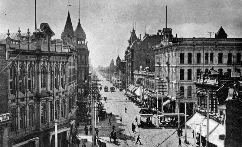
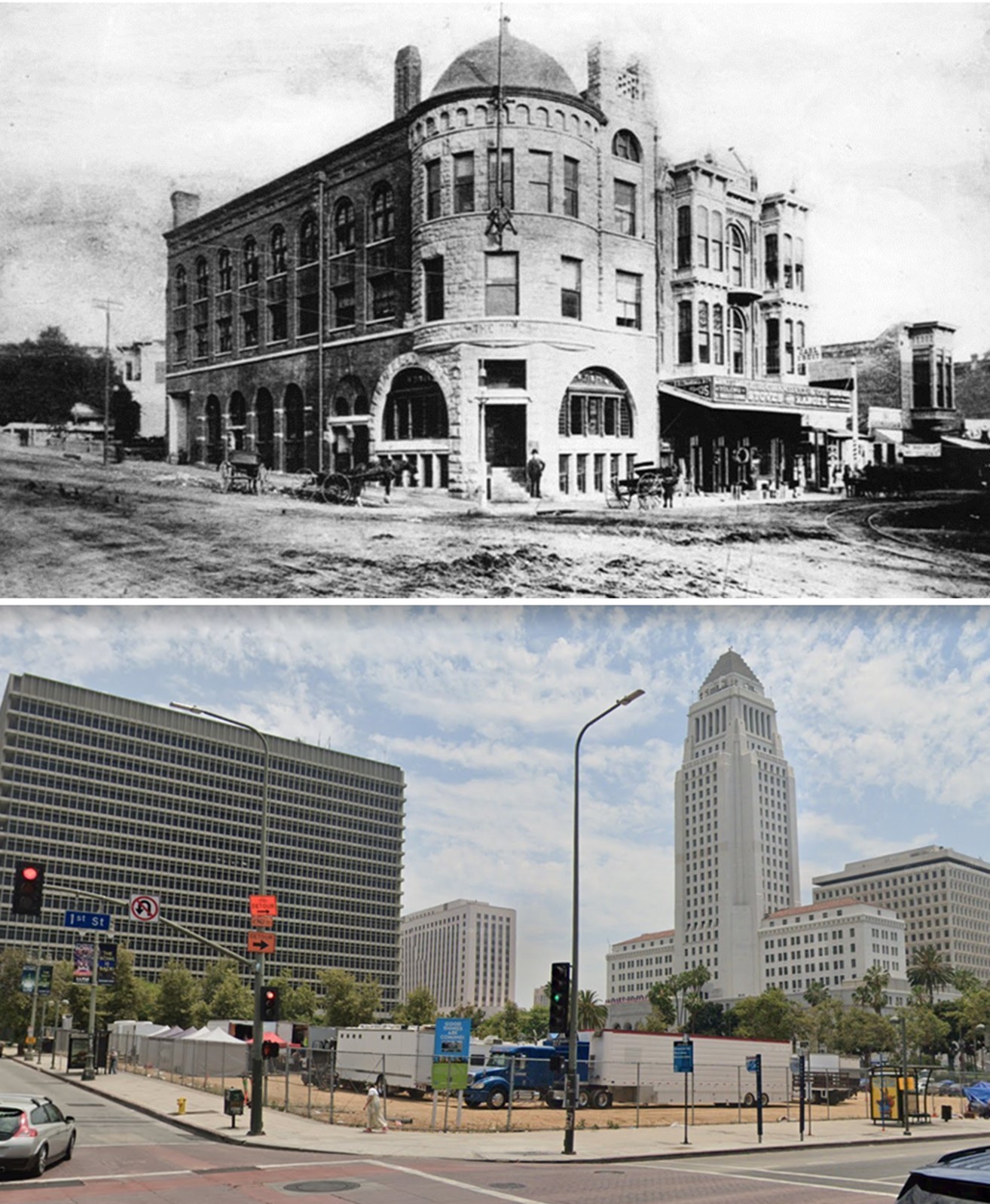
| (1884)^^* - Panoramic view looking east on First Street from Hill Street, showing the 4-story Nadeau Hotel located on the southwest corner of First and Spring streets. |
Historical Notes Remi Nadeau was a French Canadian pioneer who arrived in Los Angeles in 1861 driving a team of oxen. During the silver-mining excitement in the Cerro Gordo region of Inyo County his teamster operation brought tons of silver to Southern California and hauled back food and supplies to the miners. By 1873 he operated 80 such teams. In 1882, Remi Nadeau built the Nadeau Hotel on the corner of 1st and Spring streets. It was Los Angeles's first four-story structure and the first building with an elevator. The hotel was designed by Morgan & Walls.**## |
 |
|
| (1886)* - View of the Nadeau Hotel on the southwest corner of Spring and 1st streets. A row of horses & carriages is lined up on the street in front. A tall narrow church spire can be seen in the background on the far left. |
Historical Notes Remi Nadeau opened the hotel in 1882 with a grand ball attended by the Southland's elite. He bought the site in 1872 for the 'un-heard' of sum of $20,000. The Nadeau boasted of the first electric elevator to be installed in Los Angeles. Some of the guests at the hotel have included: Anna Held, General Nelson A. Miles, Lillian Russell, and John L. Sullivan (one-time heavyweight champion.^^* |
 |
|
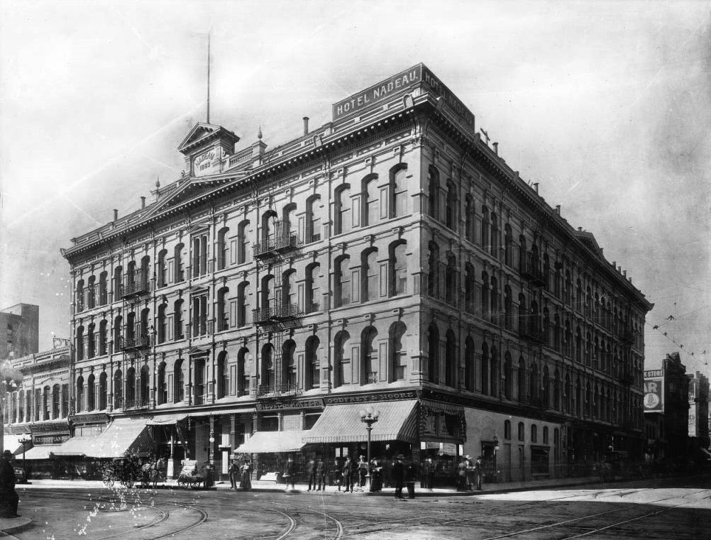
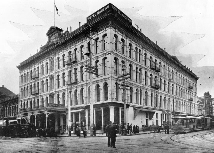
| (ca. 1905)^^* - View showing the Nadeau Hotel on the southwest corner of Spring Street and First Street. The four-story hotel features arched windows all throughout the building on the second floor and up. In the center of the building facing the street on the left are small decorative pediments above each floor from the second floor and up. At the top, above all the other small pediments, is a larger and wider pediment. Further above it is yet another pediment where underneath it displays "Nadeau 1883." The first floor consists mostly of shops. Some stores have striped cloth awnings covering their window fronts. At the corner of the hotel, on top of the roof, is a corner sign that reads "Hotel Nadeua." |
 |
|
| (1889)* - View looking south on Spring Street at 1st. Pacific Railway Company’s new streetcars are now seen on the road. The 4-story Nadeau Hotel stands on the southwest corner of Spring and 1st behind the streetcar. |
 |
|
| (1897)* - The Hotel Nadeau, showing the entire corner at 1st and Spring Streets, the present site of the Los Angeles Times. The hotel was built in 1882 as the first 4-story building in L.A. A paved street now visible. Horses, carriages, cars and trolleys, along with people are now visible. A sign giving the name of the hotel sets on the corner of the roof. The hotel advertises that it is heated by F.E. Brown's hot air furnace, and testimonials are available. Architects, Morgan & Walls. |
 |
|
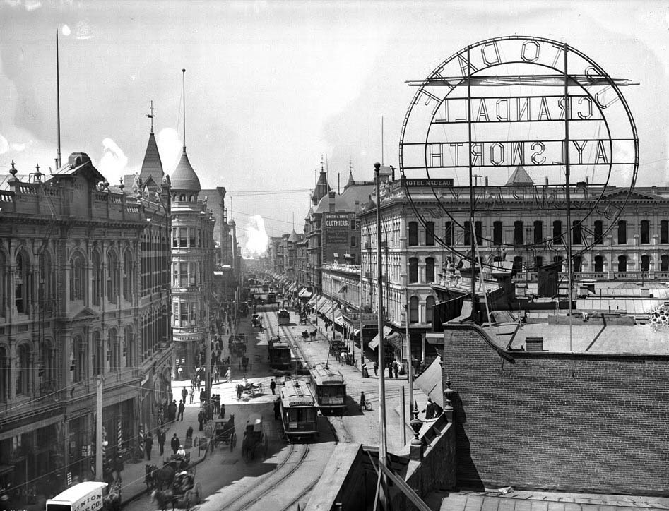
| (ca. 1904)^^* - Intersection of Spring Street and First Street looking south. The Nadeau Hotel is visible at right behind the large circular sign that reads: "Up to date bargains, Crandall Aylsworth Company". |
 |
|
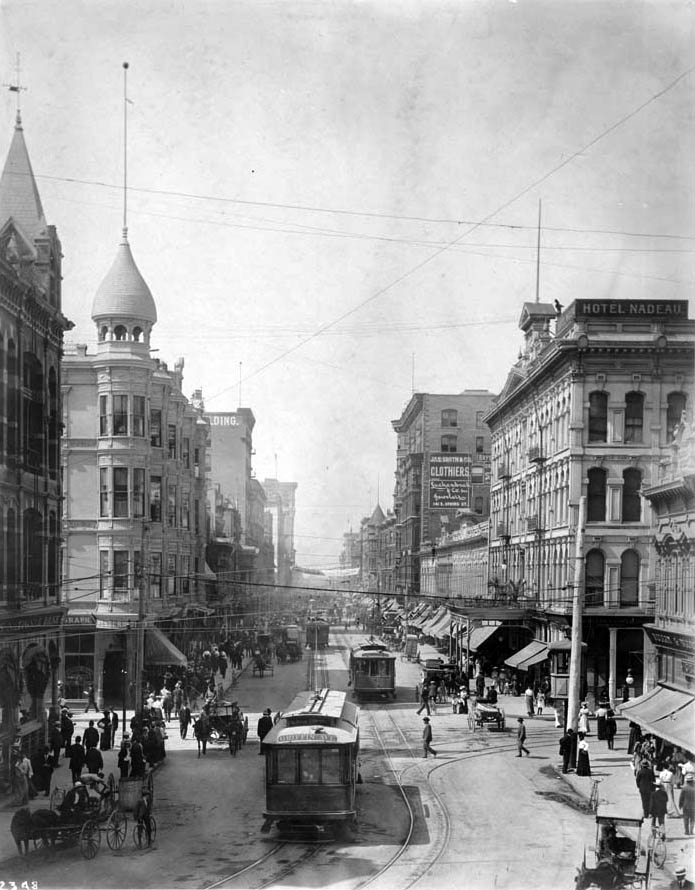
| (ca. 1905)* - View of Spring Street at 1st, looking south. The Nadeau Hotel appears on the right on the southwest corner of Spring and 1st streets. Spring St. was then the center of the city's financial activities. Electric cable cars share the street with horse-drawn wagons. |
Historical Notes The Nadeau Hotel stood on the southwest corner of 1st and Spring Streets until 1932, when it was demolished to make room for the current Los Angeles Times Building. |
* * * * * |
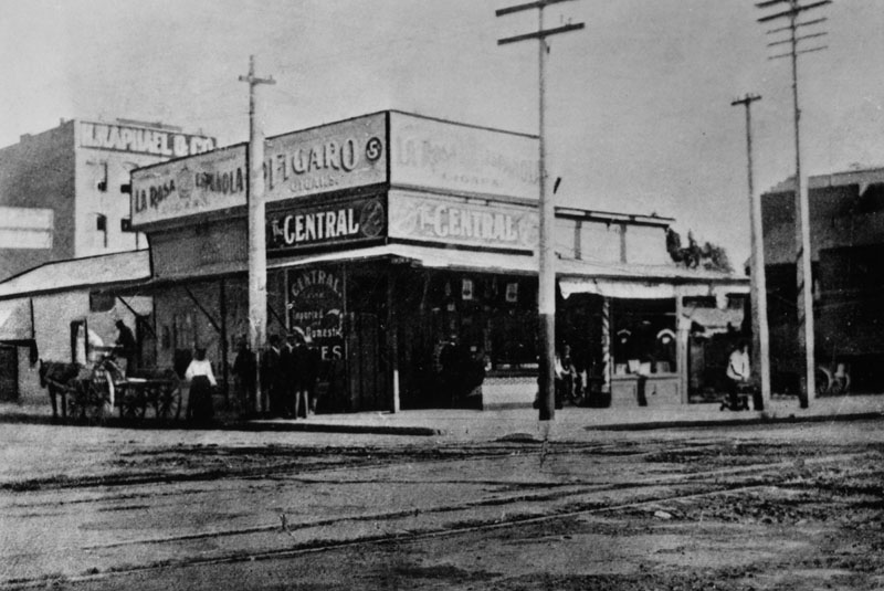
Central Saloon
 |
|
| (1886)* - An early picture of the southeast corner of Spring and 5th St. when the building was occupied by Central Saloon. |
* * * * * |
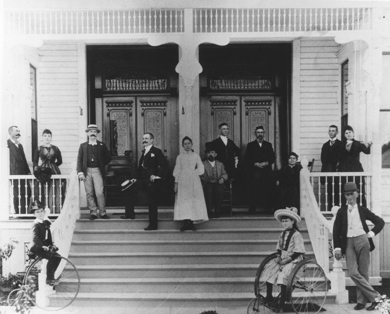 |
|
| (ca. 1886)* - Family in front of home circa 1886. Note the two styles of bicycles used by the children. |
* * * * * |
Los Angeles Times Building – 1st Location (Temple & New High, 1881–1886)
 |
|
| (ca. 1885)* – The first home of the Los Angeles Times was a modest brick building at Temple and New High Streets, where the paper operated from 1881 to 1886 before moving to 1st and Broadway. |
Historical Notes The Los Angeles Times began on December 4, 1881 as the Los Angeles Daily Times. Its first office was a small brick structure at Temple and New High Streets, near today’s Civic Center. Early publishers Nathan Cole Jr. and Thomas Gardiner struggled financially, relying on borrowed presses at the Mirror Company. In 1882, Harrison Gray Otis became editor. A Civil War veteran and staunch Republican, Otis gave the paper its conservative, pro-business voice, promoting real estate development, boosterism, and civic growth. This first building was modest and unremarkable, yet it was here that the Times began its transformation into a powerhouse of influence. By 1886, the paper had outgrown its quarters and moved to a new home at 1st and Broadway. |
* * * * * |
Los Angeles Times Building – 2nd Location (1st & Broadway, 1886–1910)
 |
|
| (ca. 1887)* – Exterior view of the Los Angeles Times Building on the northeast corner of 1st and Broadway. The building next door, at right, briefly housed the Los Angeles Chamber of Commerce (1889–1890). |
Historical Notes Completed in 1886/87, this Romanesque Revival landmark—nicknamed “The Fortress”—projected permanence and authority. Its brick and granite facade reflected the Times’ growing influence under Otis. The Chamber of Commerce next door illustrates how the paper was at the center of the city’s booming business community during the land rush of the 1880s. Horse-drawn wagons and pedestrians on the dirt road highlight a city still on the edge of modernization. |
 |
|
| (ca. 1888)* - Panoramic view looking east on an unpaved 1st Street from near Hill Street. The Times Building anchors the center on the northeast corner of 1st and Broadway. |
Historical Notes This wide view captures Los Angeles in transition—dirt roads, scattered trees, and low-rise structures alongside ambitious civic buildings. The Times Building stood as a modern symbol for a city whose population had surged with the arrival of the railroads. Under Otis, the paper promoted Los Angeles as a place of opportunity, fueling migration and investment that soon transformed these dusty streets into paved boulevards. |
 |
|
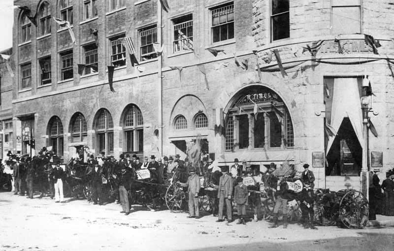
| (ca. 1887)* - Young carriers of the Los Angeles Times gathered outside the building on 1st and Broadway. |
Historical Notes Here, newsboys—the lifeblood of circulation—pose proudly with their bundles. They would hawk headlines on street corners or deliver by bicycle, making the paper visible in every neighborhood. Behind them looms the Times Building, fortress-like and imposing. These boys were the face of the paper on the street, shouting Otis’ bold editorials that promoted growth but antagonized organized labor. |
 |
|
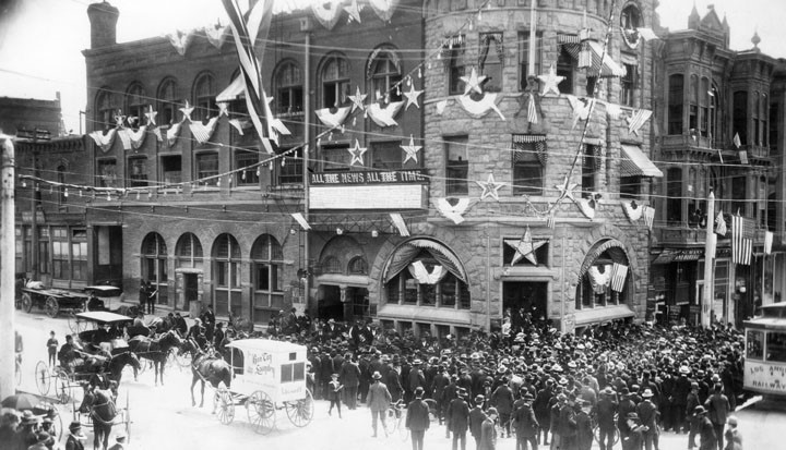
| (1890s)* - The Times Building decorated with flags and bunting; a large crowd is gathered at the entrance. Wagons and a streetcar pass by. |
Historical Notes Patriotic displays like this were common for holidays or civic rallies. The flags and bunting underscored the Times’ role as both a news outlet and a booster of civic pride. By the 1890s, electric streetcars were joining horse-drawn wagons on Broadway, showing the city’s modernization. Inside, Otis’ editorials pushed a strong anti-union line, aligning with the city’s business elite and cementing Los Angeles’ reputation as an “open-shop” town. |
 |
|
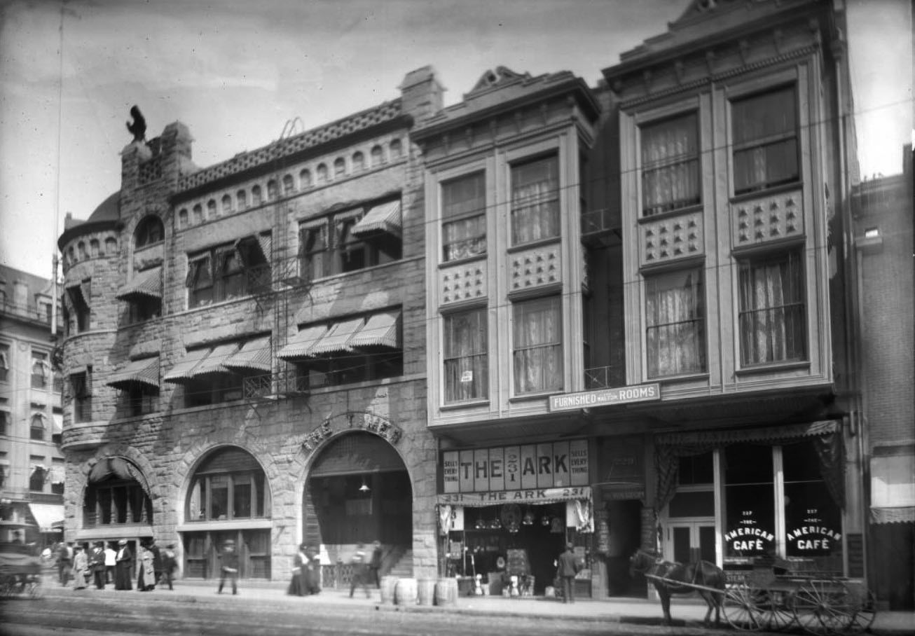
| (ca. 1905)* - North side of 1st Street with the three-story Times Building. Signs for “Furnished Rooms,” “The Ark,” and “The American Café” are visible next door. |
Historical Notes This image shows the Times surrounded by everyday businesses—boarding houses, shops, and cafes—reflecting Broadway’s bustling mix of commerce and daily life. The paper had become a fixture of the block. By now, the Times had expanded with a new wing designed by architect John Krempel (1903). Yet the city’s growing labor tensions made the building’s nickname, “The Fortress,” feel ominous: conflict with unions was escalating toward tragedy. |
 |
|
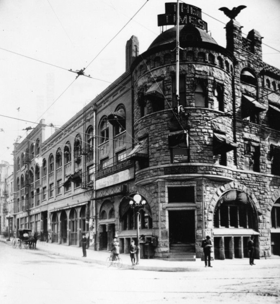
| (ca. 1905)* - The Times’ second home at 1st and Broadway, where it had operated since 1886, shown before its destruction in 1910. The first Times office had been at Temple and New High. |
Historical Notes This view captures the building at its height, with ornate detailing and a solid presence. Inside, massive presses printed thousands of papers daily. On the outside, however, union resentment of the paper’s fierce anti-labor stance was mounting. Within a few years, this proud structure would be the target of the most infamous act of labor violence in U.S. history. |
 |
|
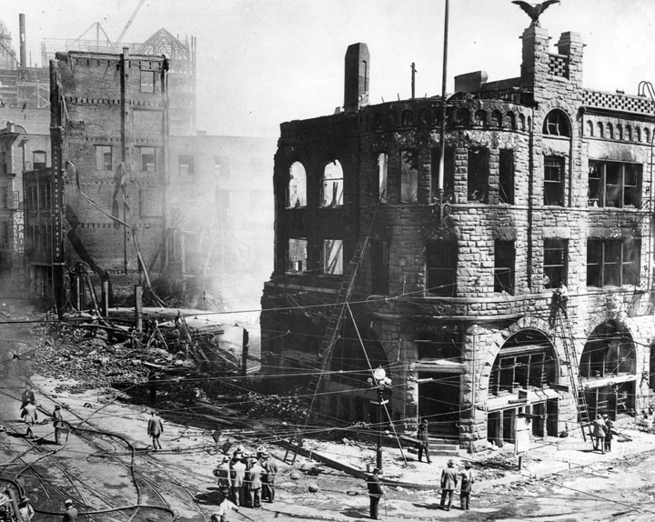
| (1910)* - Ruins of the Los Angeles Times Building after the October 1 bombing. |
Historical Notes At 1:07 a.m., a bomb exploded in “Ink Alley” behind the Times Building. The blast triggered gas and ink fires, collapsing walls and floors. Twenty-one workers were killed, many trapped in the flames. The attack, carried out by union brothers James B. and John J. McNamara, was condemned as the “crime of the century.” The devastation symbolized the bitter divide between labor and business in early Los Angeles. |
 |
|
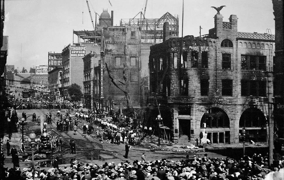
| (1910)* - Panoramic view showing the aftermath of the bombing. |
Historical Notes This sweeping image reveals the full scale of the destruction. Smoke still lingers as crowds gather around the ruins. The case drew national attention: famed attorney Clarence Darrow, representing labor, arranged a plea deal—James McNamara received life, John got 15 years. The Times vowed to rebuild, framing the attack as proof of its mission to stand against union militancy. |
 |
|
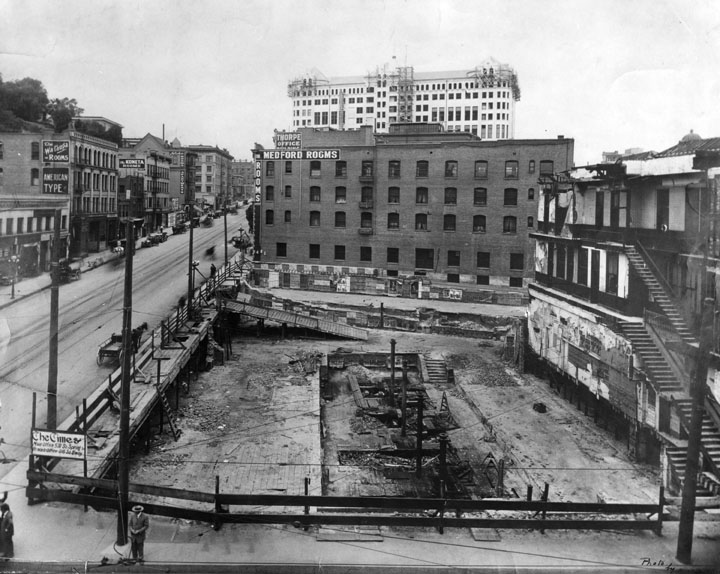
| (ca. 1911)* - Cleared site at the northeast corner of 1st and Broadway after the bombing. |
Historical Notes The lot where “The Fortress” once stood was quickly cleared. On the bombing’s first anniversary in October 1911, the Times laid a cornerstone for a new building on the same site. This third Times Building, with its castle-like tower, opened in 1912 and stood until the 1930s. The cleared site shown here marked both a literal and symbolic end to an era. |
Then and Now
 |
|
| (1887 vs 2021)* – Looking at the northeast corner of Broadway and 1st Street. Once the site of the ornate second Times Building, today it remains an empty lot. Photo comparison by Jack Feldman. |
Historical Notes The contrast is striking: the bustling 1887 street scene—with its carriages and landmark architecture—versus today’s vacant parcel. After the bombing, two successive Times buildings rose here, but by the late 20th century the site was cleared again. Long proposed as the “First & Broadway Civic Center Park,” it remains empty as of 2024, a quiet reminder of the explosive history that once shook Los Angeles. |
* * * * * |
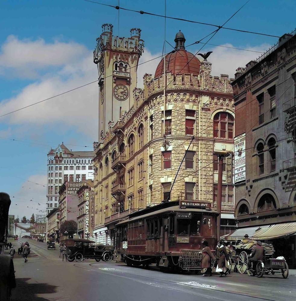
LA Times Building (3rd Building, 1912–1935)
 |
|
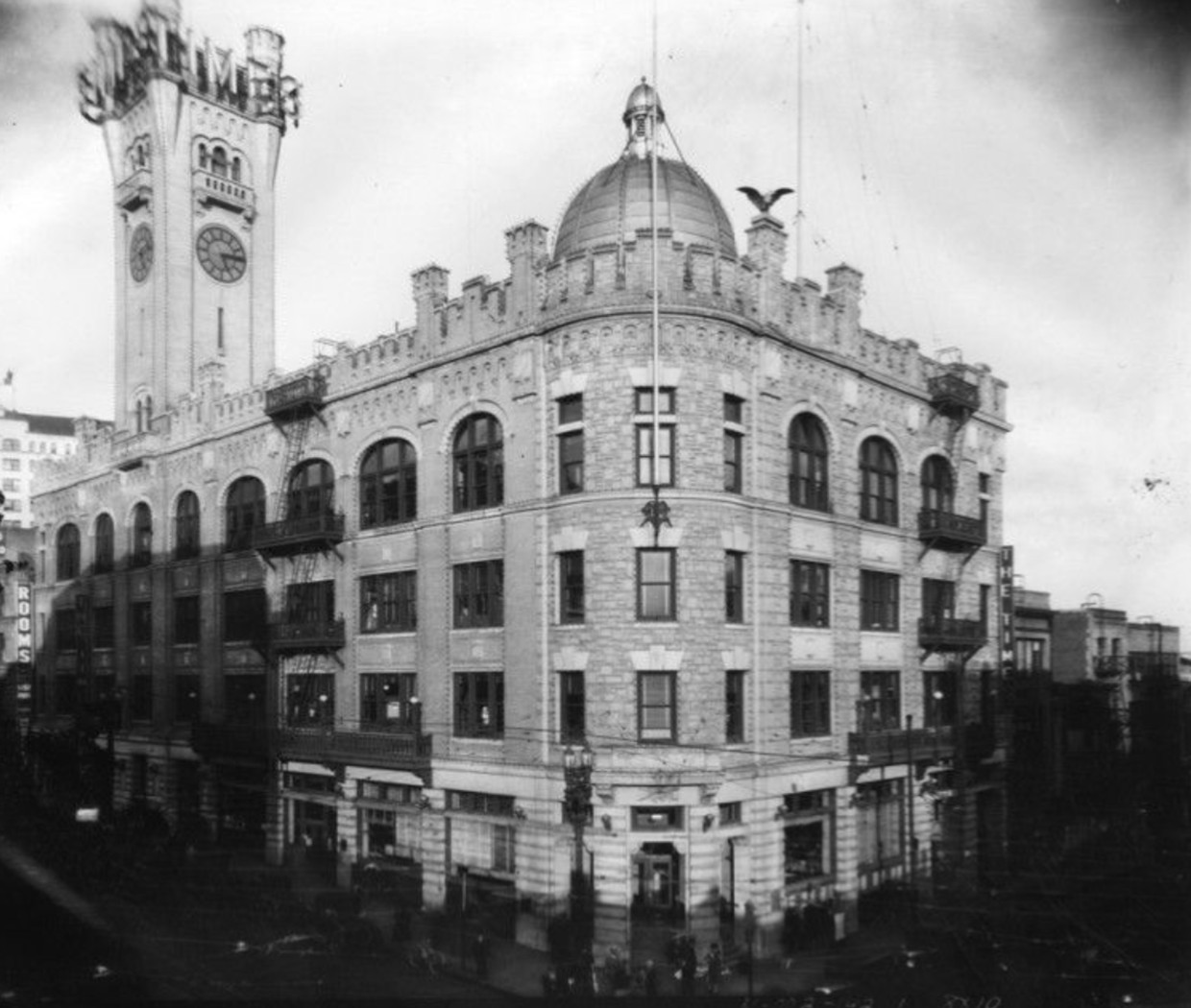
| (ca. 1912)* - View of the new Times Building shortly after it was rebuilt. Note the new castle-like clock tower. |
Historical Notes The third Times Building opened on October 1, 1912, exactly two years after the 1910 bombing destroyed the previous one. Its large stone walls and clock tower were meant to show strength and recovery. This building served as Times headquarters until 1935 and was torn down in 1937–38. |
 |
|
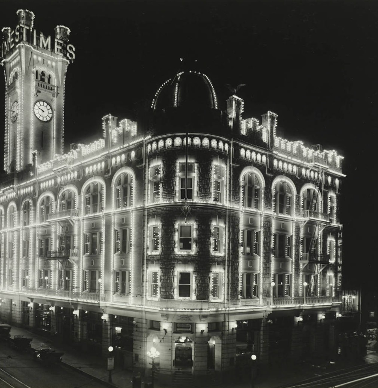
| (ca. 1912)* – The newly constructed Times Building lit up with decorative lights. |
Historical Notes In the early 1900s, lighting a building at night was a symbol of pride and progress. The clock tower became a landmark for evening events downtown. |
 |
|
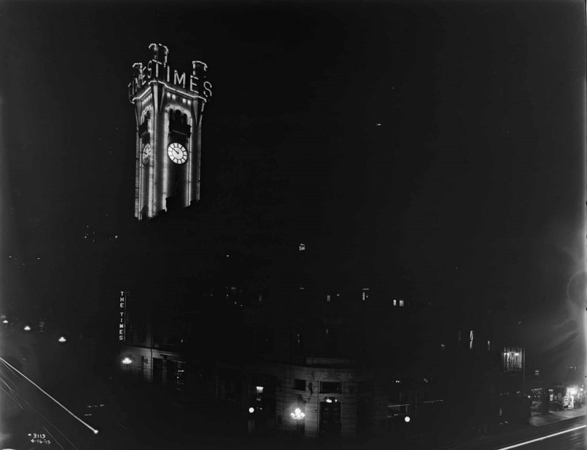
| (1915)* – Night view showing the illuminated clock tower of the LA Times Building. Photo Date: April 16, 1915 |
Historical Notes The Times often lit up the tower for holidays and special occasions. At night it was one of the brightest and most recognized features of downtown. |
 |
|
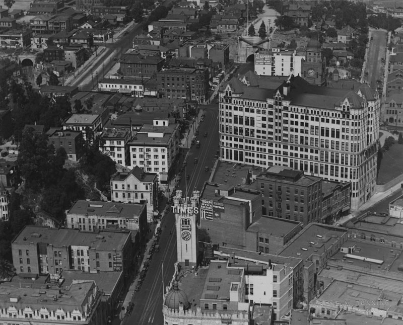
| (ca. 1925)* - Civic Center view looking north from 1st & Broadway. The Times Building is in the foreground. Behind it are the Hall of Records, the old County Courthouse, and the Broadway Tunnel. |
Historical Notes This photo shows the Civic Center of the 1920s, when Broadway was lined with government and newspaper buildings. The Broadway Tunnel, dug through Fort Moore Hill in 1901, carried cars north until it was closed in 1949. |
 |
|
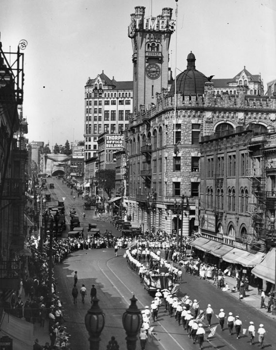
| (1920s)* - A parade on Broadway turns east onto 1st Street. The Times Building stands on the NE corner, with the Broadway Tunnel in the distance. |
Historical Notes Parades often went past the Times corner. The tower gave the corner a strong presence, making it a natural gathering spot for crowds. |
 |
|
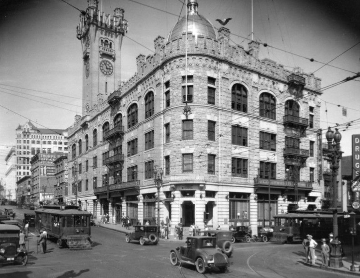
| (1926)* - Streetcars, cars, and pedestrians crowd the busy intersection at 1st & Broadway. The Times Building stands on the NE corner. |
Historical Notes By the 1920s, the area mixed cars, streetcars, and thousands of pedestrians every day. The Times was part of a lively block that included shops and cafes. |
 |
|
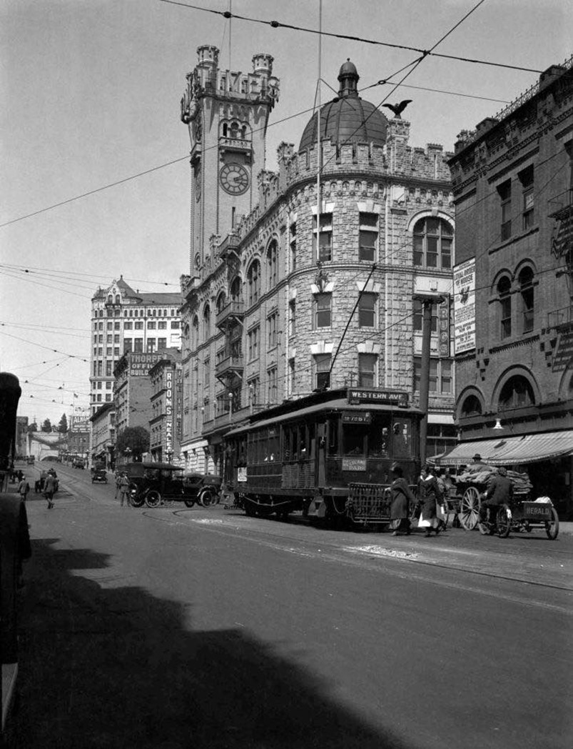
| (1920s)* – Looking north on Broadway just south of 1st Street. A bicyclist delivers newspapers as a Pacific Electric car heads north. The Times Building is on the NE corner. |
Historical Notes In this era, newspapers were delivered by bike, wagon, and streetcar. The Times Building shows how important newspapers were to city life. |
 |
|
| (1920s)* – Looking north on Broadway toward 1st Street with the ornate Los Angeles Times building seen on the NE corner. Photo Source: Homestead Museum; AI image enhancement and colorization by Richard Holoff |
* * * * * |
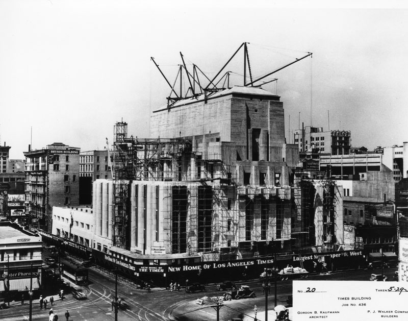
Los Angeles Times Building (4th Building, 1935–2018)
 |
|
| (1934)* - Construction site for the new Times Building at 1st & Spring. A sign reads “New Home of Los Angeles Times – largest newspaper in the West.” |
Historical Notes Publisher Harry Chandler built this new headquarters during the Great Depression to show the paper’s power and stability. Designed by Gordon B. Kaufmann in the Art Deco style, it opened in 1935. |
 |
|
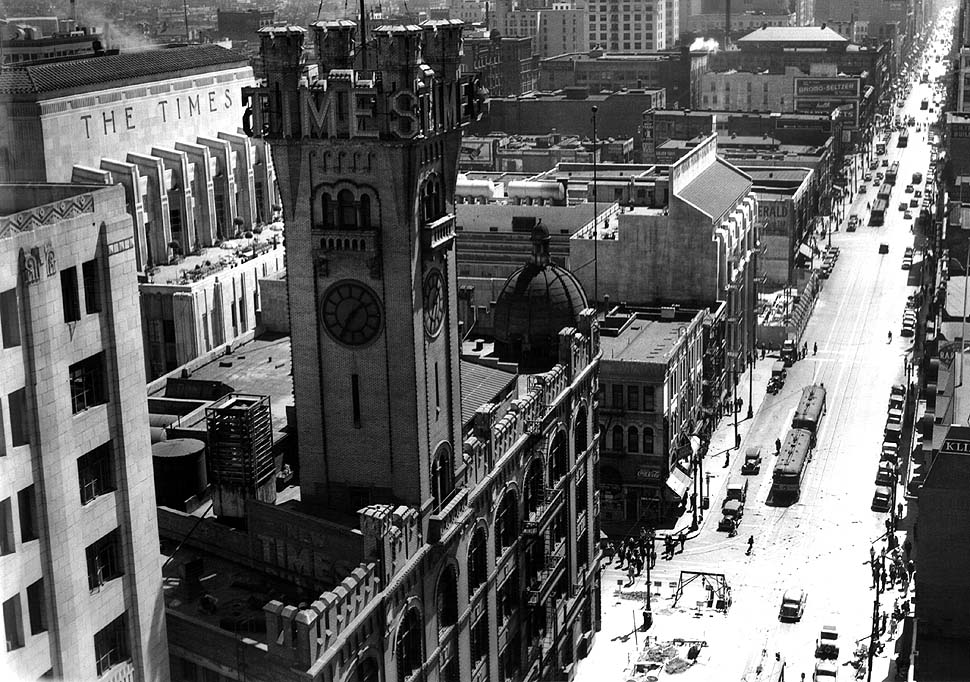
| (1934)* - View looking south on Broadway at 1st Street. The older Times Building (NE corner of 1st & Broadway) still stands while the new Times Building rises at 1st & Spring. |
Historical Notes For a short time, both Times buildings stood across from each other. The new headquarters became the centerpiece of Times Mirror Square, which later expanded in 1948 and 1973. |
 |
|
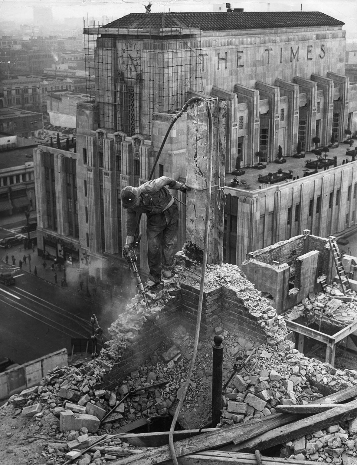
| (1937)* - The new Times Building rises across 1st Street while a worker demolishes the old Times Building at the NE corner of 1st & Broadway. |
Historical Notes The old Times tower was torn down in 1937–38. The new Art Deco headquarters featured the famous “Globe Lobby” with murals by Hugo Ballin and a giant globe of the world. In 1937, it won a gold medal at the Paris Exposition. In 2016, the 1935 Times Complex was sold to Vancouver’s Onni Group, even as the Times continued leasing space. The paper moved to El Segundo in 2018. Today, the site sits empty. Plans under consideration include reusing parts of the complex for mixed‑use—offices, residences, shops—while preserving its historic Art Deco features. Click HERE to see more Early Views of the 4th Times Building |
* * * * * |
Fire Station (Spring and 9th Streets)
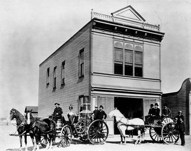 |
|
| (1887)* - Horse-drawn fire engine and cart in front of Los Angeles fire station house at southwest corner of 9th and Spring streets. Notice all the men above are in street clothes. The firehouses were staffed by volunteers until the end of 1887. |
Historical Notes In December 1885, the City Council considered the merits of a fully paid Department and moved to finance and control the first fully paid, official Los Angeles Fire Department (LAFD). In February 1886, the LAFD officially went into service with four fire stations. It took until 1887 for the City’s LAFD to establish its own fire station, Engine Company No. 1, the Old Plaza Firehouse. Click HERE to see more on the Old Plaza Firehouse in Early Plaza of Los Angeles. |
* * * * * |
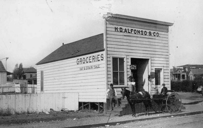
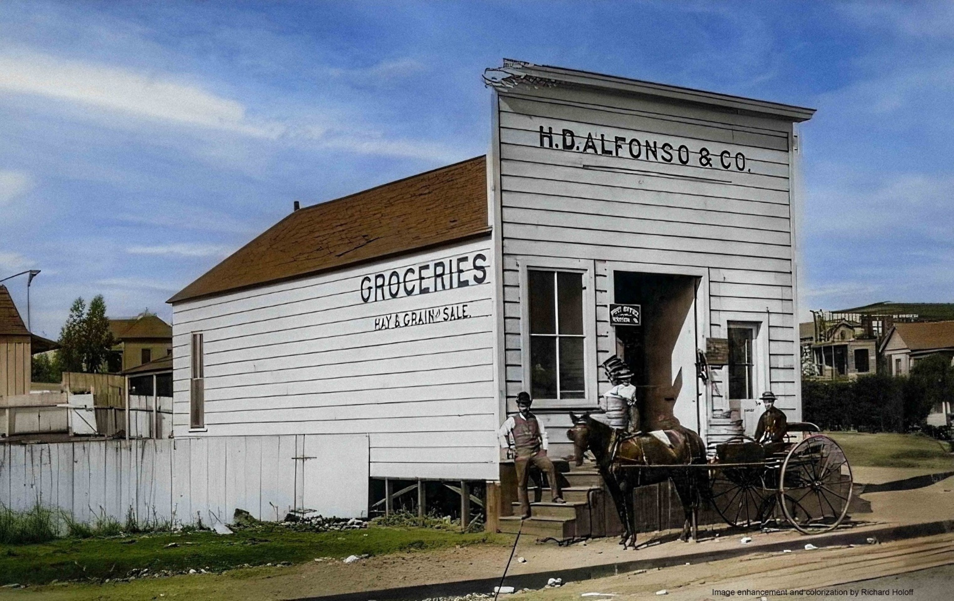
H. D. Alfonso & Co. Grocery
 |
|
| (1887)* - View showing thef H. D. Alfonso & Co. grocery and feed store located at the corner of Temple and Main. The unattached one-story wooden frame building has steps leading to the entrance. A sign at the door indicates that the premise is authorized to be a post office station. A man and boy pose on the steps and a man in a horse and buggy are in front. On the side of the building is painted: "Groceries, Hay and Grain for sale". A house is being constructed in the background. |
 |
|
| (1887)* - View showing thef H. D. Alfonso & Co. grocery and feed store located at the corner of Temple and Main. The unattached one-story wooden frame building has steps leading to the entrance. A sign at the door indicates that the premise is authorized to be a post office station. A man and boy pose on the steps and a man in a horse and buggy are in front. On the side of the building is painted: "Groceries, Hay and Grain for sale". A house is being constructed in the background. Image enhancement and colorization by Richard Holoff. |
* * * * * |
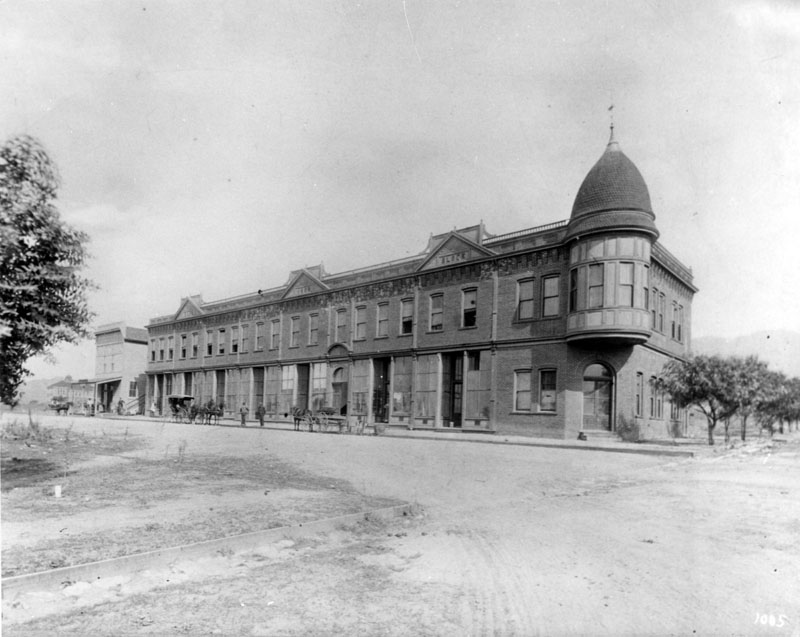
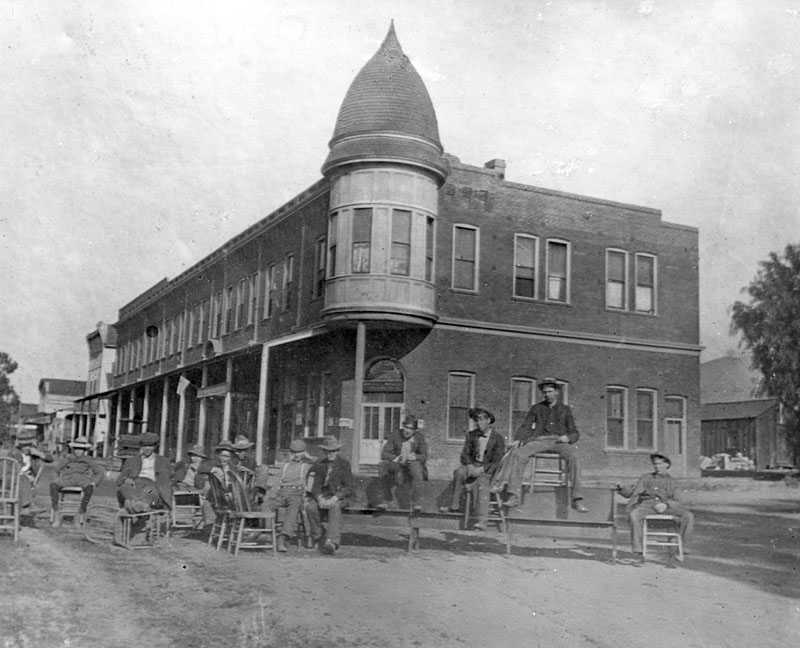
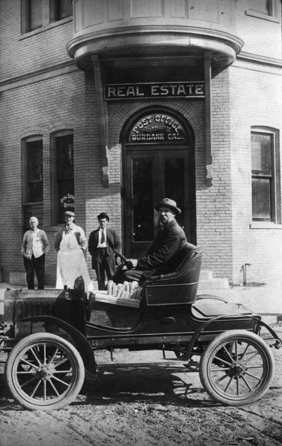
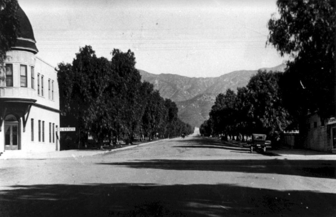
Burbank Block
 |
|
| (1887)^*^^ - View of the Burbank Villa Hotel looking north on Olive Avenue. It was built by Dr. David Burbank and his son-in-law John W. Griffin. Behind it and to the right is the Burbank Block. |
Historical Notes At the time the American Civil War broke out Dr. David Burbank established his profession as a dentist in Pueblo de Los Angeles. In 1867, he purchased Rancho La Providencia from David W. Alexander and Francis Mellus, and he purchased the western portion of the Rancho San Rafael (4,603 acres) from Jonathan R. Scott. Dr. Burbank's property reached nearly 9,200 acres at a cost of $9,000. He eventually became known as one of the largest and most successful sheep raisers in southern California, resulting in him stopping his practice of dentistry and investing heavily in real estate in Los Angeles.^* The Burbank Villa Hotel cost $30,000 to build and was later renamed the Santa Rosa Hotel which was a popular place for weddings and galas. The hotel was remodeled into apartments in the 1920's and by 1927 was torn down and later replaced by the Downtown Burbank Station (Bob Hope) Post Office.^*^^ |
 |
|
| (1895)* - Exterior view of the Burbank Block (Brick Block), the first brick building in town located at San Fernando Road and Olive Avenue. Horse-drawn carriages are parked alongside of the building. |
 |
|
| (1889)* - Group photo of several men sitting in front of the Burbank Block. The Burbank Block was the first brick building in town, located on San Fernando Road (now Golden Mall) and Olive Avenue in Burbank. The Brick Block was erected during 1887 by the Provedencia Land & Water Co. for the newly planted town of Burbank. |
 |
|
| (1911)^.^ – Four men pose for the camera in front of the Burbank Post Office located in the Brick Block Building. Sign over the doorway also reads “Real Estate”. Note the early model car has the steering wheel on the right.. |
 |
|
| (ca. 1915)^.^ - View looking north on Olive Avenue from San Fernando Road towards the Verdugo Mountains with the Brick Block Building seen on the left. |
* * * * * |
Early Compton
 |
|
| (1887)* - This business block in Compton includes a hardware and grocer. A horse-drawn cart can be seen at right. Shop owners are standing in front of the brick building housing various businesses, posing for the camera. |
Historical Notes In 1867, Griffith Dickenson Compton led a group of thirty pioneers to the area. These families had traveled by wagon train south from Stockton, California in search of ways to earn a living other than in the rapid exhaustion of gold fields. Originally named Gibsonville, after one of the tract owners, it was later called Comptonville. However, to avoid confusion with the Comptonville located in Yuba County, the name was shortened to Compton. Griffith D. Compton donated his land to incorporate and create the city of Compton in 1889, but he did stipulate that a certain acreage be zoned solely for agriculture and named Richland Farms. In January 1888, a petition supporting the incorporation of Compton was forwarded to the Los Angeles County Board of Supervisors, who in turn forwarded the petition to the State Legislature. On May 11, 1888 the city of Compton was incorporated, it had a total population of 500 people. The first City Council meeting was held on May 14, 1888.^* Click HERE to see more Early Views of Compton. |
* * * * * |
Wolfskill Ranch
 |
|
| (ca. 1880)^ - Full frame lithograph photo of the orange and lemon groves on the Wolfskill Ranch, residence of William Wolfskill. The Los Angeles and Independence Railroad Station can be seen in the background. The Southern Pacific Arcade Station would be built on the Wolfskill Ranch in 1888. |
Historical Notes William Wolfskill, a native of Kentucky, came to California in 1831 and settled in Los Angeles in 1836, where he soon met and married Magdalena Lugo, daughter of Jose Ygnacio Lugo. In March 1838, Wolfskill purchased a 100-acre lot bounded by 3rd to 9th streets and San Pedro to Alameda streets, which he named Wolfskill Ranch, and built a large adobe (known as "Wolfskill Adobe") located at 239 Alameda, between 3rd and 4th streets. In 1839 Wolfskill became a major grape producer when he planted the first vineyard of table grapes in California. Two years later, in 1841, he planted his first 2-acre plot of citrus behind his adobe, between 4th and 6th streets east of Alameda. In a short period of time, Wolfskill's farm had increased to 28-acres of planted citrus with over 2,500 orange trees. By 1862 he owned 3/4 of all the orange trees in California and was the biggest orange grower in the United States - for which he is considered the father of early California citrus industry. In 1865, Wolfskill purchased Rancho Santa Anita, where he planted eucalyptus seeds that he had imported from Australia. The eucalyptus trees, which still stand today, were the first of their kind in California.* |
 |
|
| (ca. 1880s)* - Exterior view of the William Wolfskill adobe (simply known as the "Wolfskill Adobe") located at 239 Alameda, between 3rd and 4th streets. It shows one side of the white L-shaped adobe behind several palms and trees. A gentleman can be seen leaning against a low post - possibly used to tie horses, as a pile of manure is visible near his feet. |
Historical Notes William Wolfskill died in 1866 at the age of 68, but the property remained in the family, with his son Louis Wolfskill taking over the operation of the ranch. Eventually, all but seven acres of the Wolfskill Ranch would either be sold or subdivided.* John Wolfskill, William's younger brother, owned the Wolfskill Ranch on land that would later become Westwood and UCLA. Click HERE to see more in Early Views of UCLA. |
 |
|
| (1887)* - Front view of the Wolfskill Adobe showing a low hedge separating the house from a dirt pathway, possibly a driveway. A few trees can be seen in the surrounding area and another house or building is visible in the background on the right. |
Historical Notes In 1887, the still-standing Wolfskill Adobe would be razed to make way for the old Southern Pacific Railroad's Arcade Station, which was located at Fifth and Alameda. This, too, would be demolished in 1914 and replaced with a larger and more modern railroad passenger depot - the Central Station. In 1916, the Ice & Cold Storage Plant was built on a portion of the land, and was located on 3rd and Central avenues. By 1958, the Ice & Cold Storage Plant had become Young's Market Company, located at 500 S. Central Avenue.* |
* * * * * |
Arcade Depot Palm and the Arcade Depot
 |
|
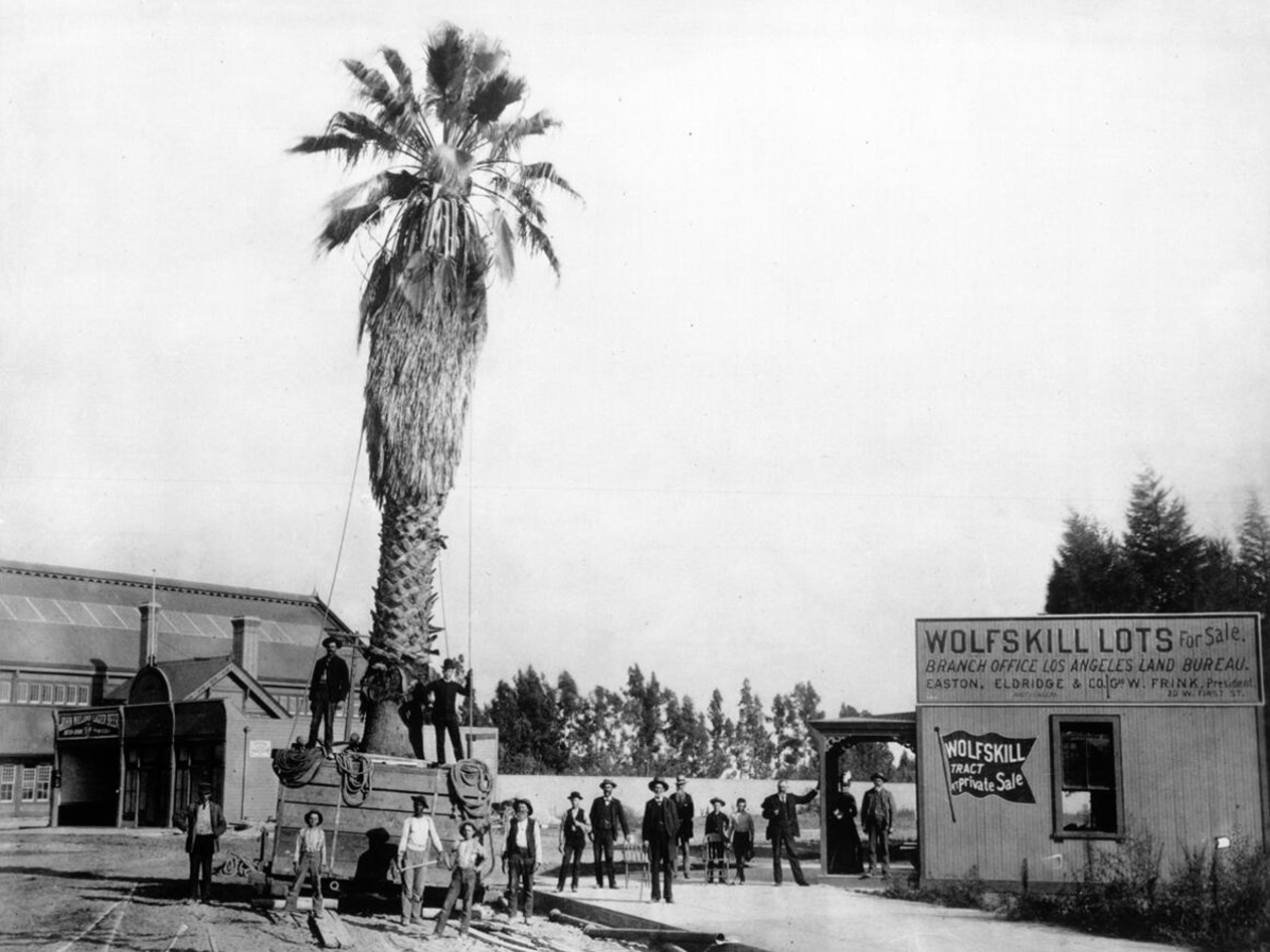
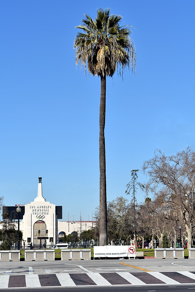
| (1889)* - View of a palm tree being moved to the front of the recently completed Arcade Depot on Fourth Street and Central Ave on land that was once occupied by the Wolfskill Adobe. Amazingly, the original Arcade Depot palm seen above is still alive. It was replanted at a location in front of the Los Angeles Coliseum where it stands today. It along with the Longstreet Palms are considered to be the oldest trees in the City of Los Angeles (see more below). |
Historical Notes The Arcade Train Depot, also known as the Arcade Station, played a significant role in the development of Los Angeles' transportation infrastructure during the late 19th and early 20th centuries. The Arcade Depot was constructed by the Southern Pacific Railroad and opened in 1888. It was strategically located on Central Avenue between 5th and 6th Streets, on land that was previously part of the orange groves owned by William Wolfskill. The city of Los Angeles provided this land to entice the railroad to establish a major terminal in the city. A fully-grown Washington fan palm, moved from a site nearby, stood outside the station's entrance, symbolically welcoming newcomers to a supposed subtropical paradise. |
 |
|
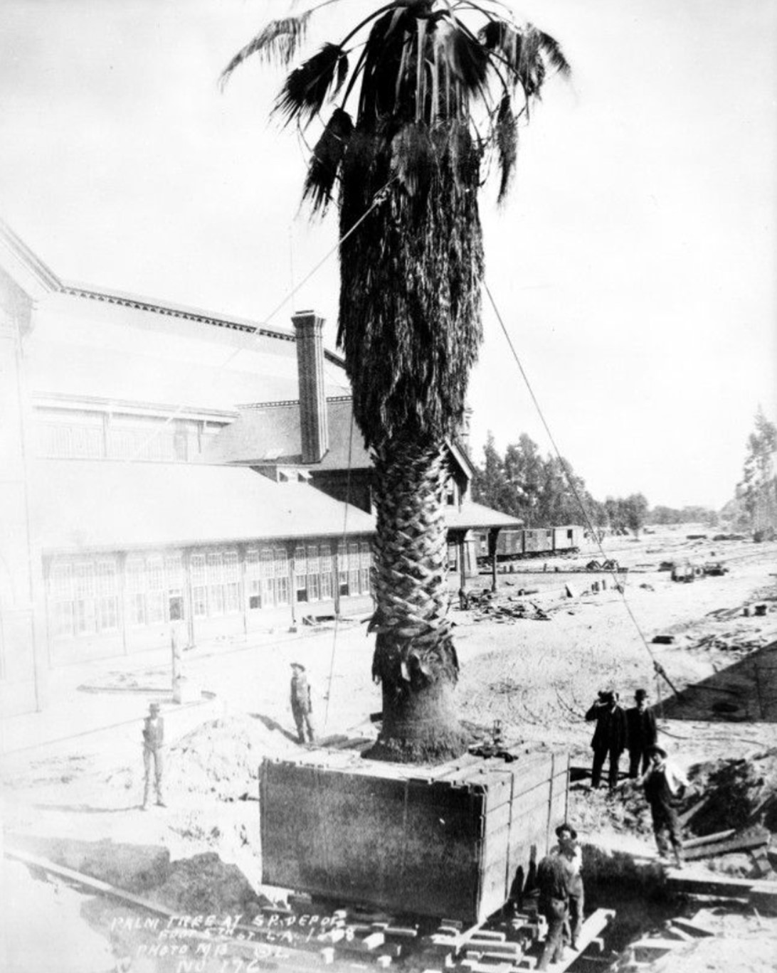
| (1889)* - A very large palm tree (aka Washingtonia filifera fan palm) being planted outside of the Arcade Station at Central Avenue between 4th and 5th Streets. |
Historical Notes The palm tree, a Washingtonia filifera fan palm, is believed to have started its life in the 1850s in a backyard on San Pedro Street, between 2nd and 3rd Streets. In 1889, the 30-foot palm was chosen to be transplanted to a prominent location in front of the entrance to the Arcade Depot, the Southern Pacific Railroad's new transcontinental terminus. This strategic placement made the palm the first sight that greeted newcomers arriving in Los Angeles by train, offering a welcoming view after long journeys from the colder eastern regions. |
 |
|
| (1890)* - A dozen horse-drawn wagons wait for the next train to arrive at the Southern Pacific Arcade Depot with the Arcade Palm standing in front of the depot. |
Historical Notes The establishment of the Arcade Depot was a pivotal moment in Los Angeles' history, marking the city's emergence as a major transportation hub. The station facilitated increased connectivity with the rest of the United States, contributing to the population boom and economic growth of Los Angeles during the late 19th century. The influx of tourists and new residents helped transform Los Angeles from a relatively small town into a burgeoning metropolis. |
 |
|
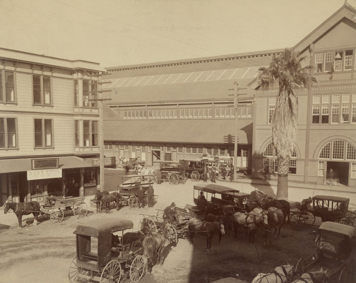
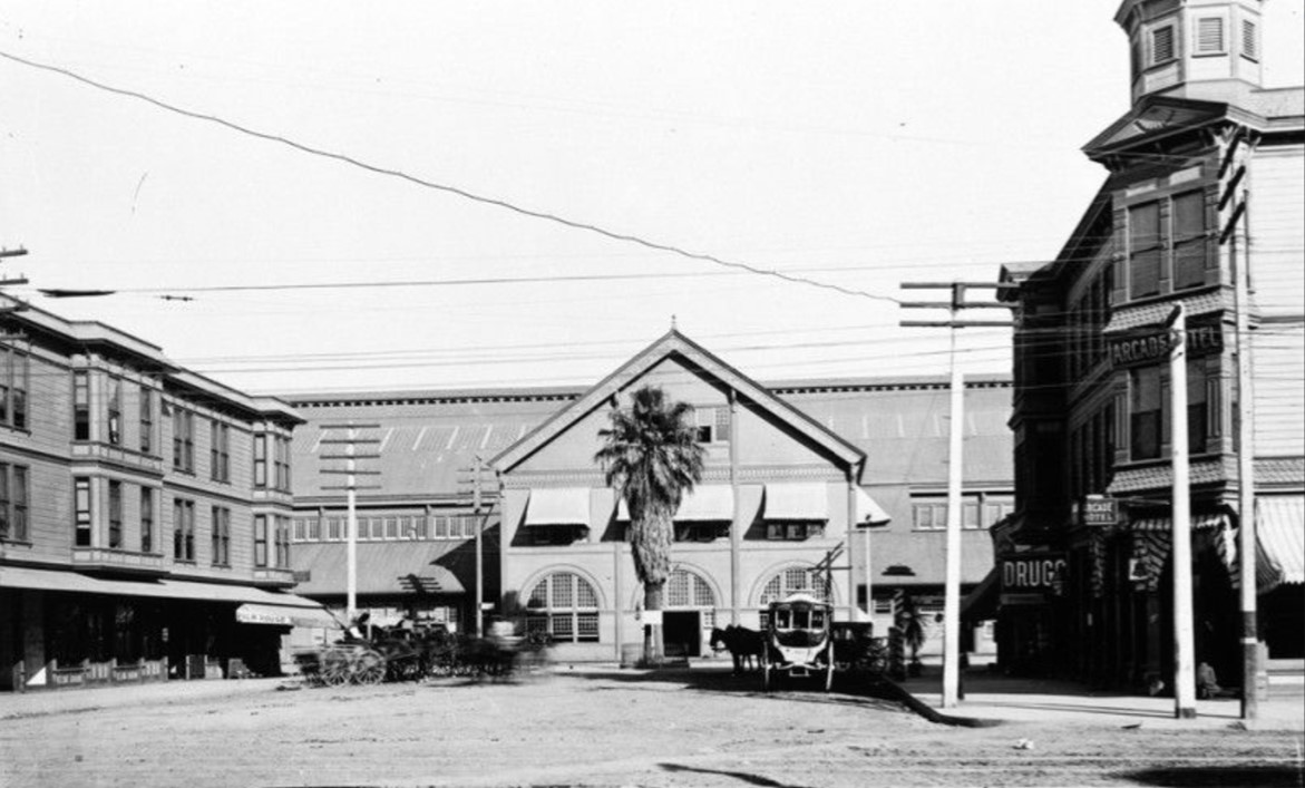
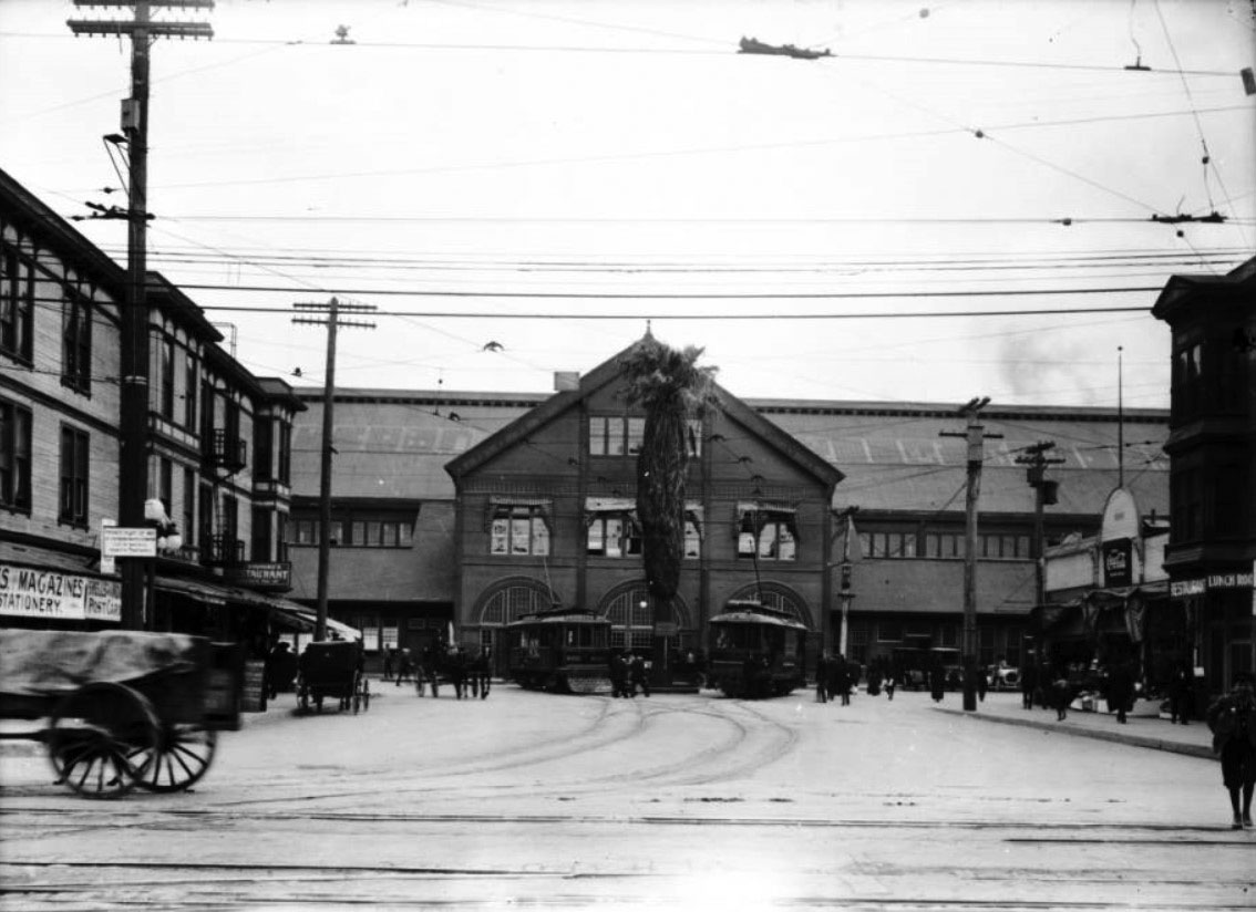
| (1896)* - Front view of the Southern Pacific Railroad Arcade Depot at end of 5th Street and Central Avenue in Los Angeles; the main building has arched windows at first level, square windows with awnings on second floor. A large palm tree (Arcade Palm) stands at center with horse-drawn carriages on both sides waiting for passengers to arrive. |
Historical Notes The sign in front of the palm reads “FAST DRIVING NOT ALLOWED On These Premises”. |
 |
|
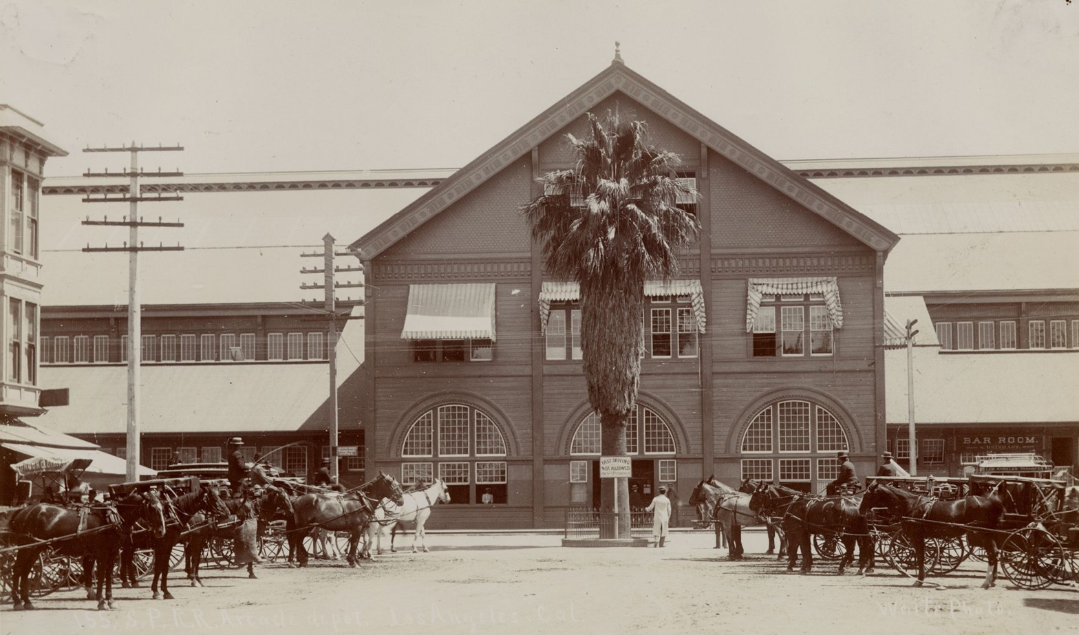
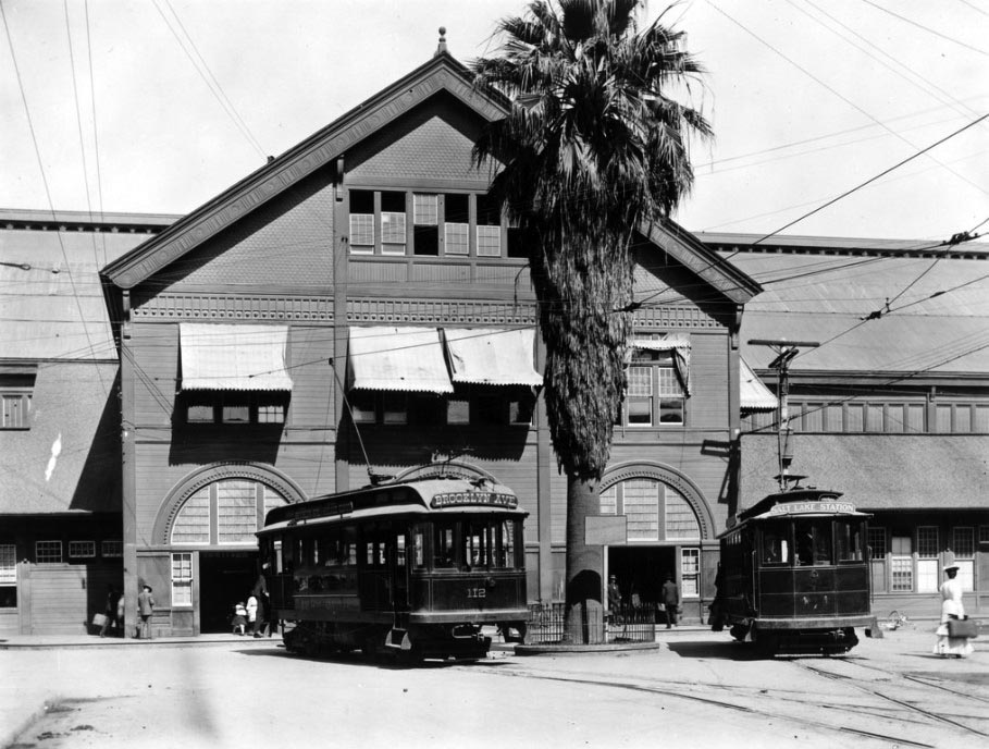
| (1890s)* - Close-up view of the Arcade Depot with it's now-famous palm tree standing tall in front of the main entrance. Horse-drawn carriages can be seen waiting for the arrival of passengers, 526 Central Avenue. |
Historical Notes For about 25 years (1889 – 1914), the palm stood as a landmark at the Arcade Depot, becoming a familiar sight to thousands of Los Angeles residents and visitors. |
 |
|
| (1910s)* - Horse and buggies are parked outside the Arcade Station on the east side of Central Avenue at the end 5th Street. The singular Arcade palm tree can be seen in front of the station, the same tree seen being planted in the earlier 1889 photo. |
 |
|
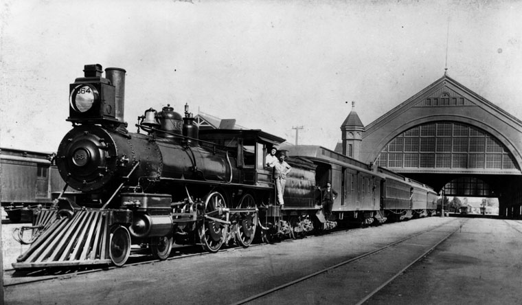
| (1891)* - Southern Pacific steam engine no. 1364 heads the train at the Arcade Station at Central Avenue between 4th and 5th St. |
Historical Notes The Arcade Station was the second station built by Southern Pacific in Los Angeles (and first one built primarily for passenger service). Built in 1889 and used until 1914 when it was replaced by larger SP Central Station. It was demolished shortly thereafter. |
 |
|
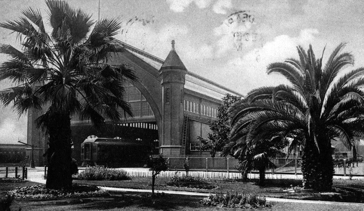
| (n.d.)^ – Postcard view of the Southern Pacific Arcade Depot looking towards the southeast. A passenger car is visible at the building's entrance. Four palm and fruit trees, a rose bush and flower beds are visible in the park in the foreground. |
Historical Notes The Southern Pacific Arcade Depot was one of three railroad depots that served the Los Angeles area before the construction of Union Station in 1939. The Arcade Depot was originally constructed in 1888 at 5th Street and Central Avenue, on acreage originally owned by William Wolfskill and used for cultivating the first commercial orange grove in Southern California. In 1914, the station was rebuilt on an adjoining site, and renamed Central Station. Central Station also became the site of the Union Pacific Railroad's downtown Los Angeles passenger terminal in 1924 when its original passenger depot was destroyed by fire. The Central Station, along with the "La Grande" Santa Fe Railroad Passenger Depot, was replaced in 1939 by Union Station and later demolished. |
 |
|
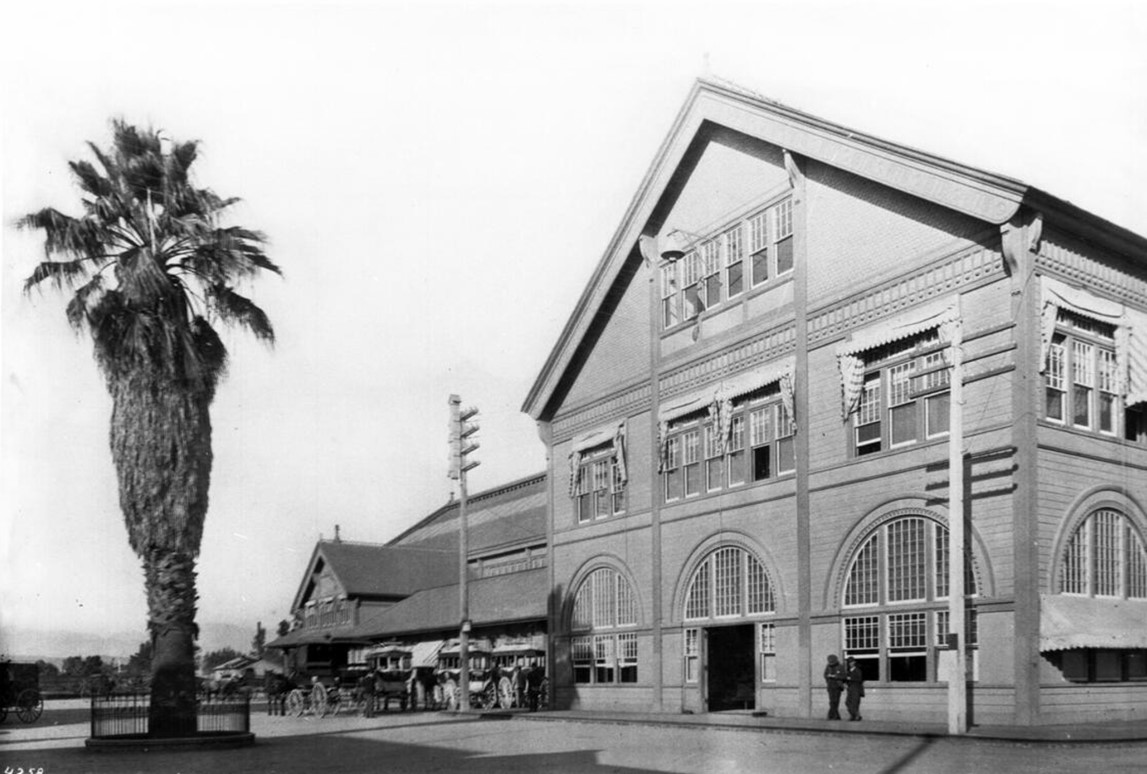
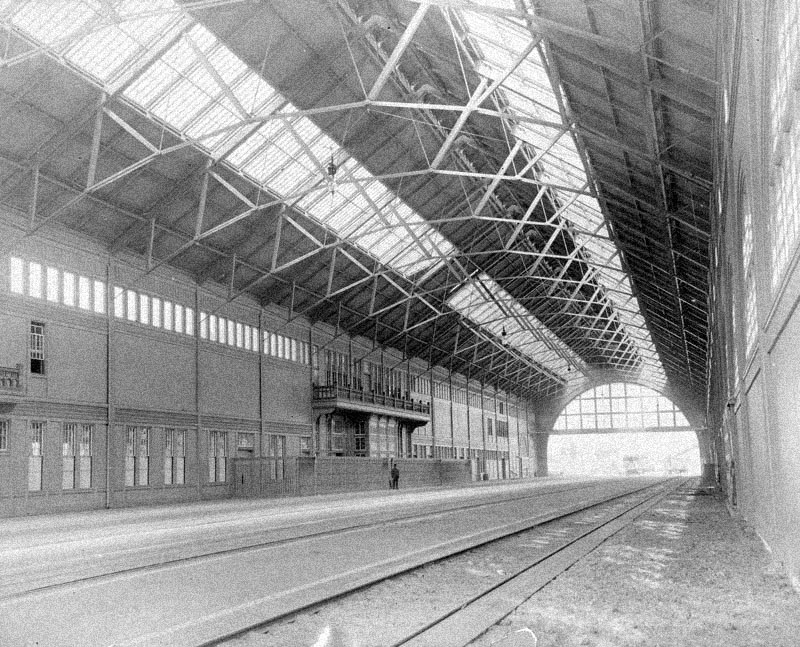
| (n.d.)* - Interior view of an empty Arcade Depot. The trains appear to be sitting outside the building. |
Historical Notes The depot itself was a massive, wooden Victorian structure reminiscent of European train stations. Five hundred feet long, the depot's rail shed featured skylights and an arched roof that soared 90 feet above the platforms below. Upon its opening, the Los Angeles Times praised the Arcade Station as "second to none on the Pacific Slope” . |
 |
|
| (ca. 1895)* - View showing the first streetcar on the L.A. Consolidated Electric R.R. in front of Southern Pacific's Arcade Station. |
Historical Notes The Arcade Depot replaced the older Southern Pacific River Station as the primary passenger terminal in Los Angeles. It served not only mainline steam trains but also the Pacific Electric Red Cars, which were a significant part of the city's public transportation network at the time. On October 14, 1890 'General' Moses Sherman founded the Los Angeles Consolidated Electric Railway in Downtown Los Angeles. He received a 50-year franchise from the city and sold stock to help build his street car railroad. In January, 1891 Sherman made is brother-in-law, Eli P. Clark, vice-president and manager of the Los Angeles Consolidated Electric Railway, the predecessor of the Los Angeles Pacific Railroad. The company built 47 miles of track radiating out around from Arcade Depot at 6th and Central Streets in downtown Los Angeles. |
 |
|
| (ca. 1914)* - View looking east on Fifth Street as it ends at the Southern Pacific Railroad Arcade Depot on Central Avenue. Two streetcars are parked in front of the railroad building on tracks that intersect with more tracks in the foreground. Several horse-drawn vehicles are visible, as well as many pedestrians making their way along the sidewalks that border the streets. The ‘Arcade Depot Palm’ is seen standing near the center of the building. |
Historical Notes In 1914, the Southern Pacific Railroad replaced the Arcade Station with the Central Station, a larger and more modern railroad passenger depot. The Union Pacific Railroad moved its Downtown Los Angeles passenger terminal to Central Station in 1924 after its original passenger depot just south of First Street on the east side of the Los Angeles River was destroyed by fire. |
 |
|
| (ca. 1905)* – View showing two Pacific Electric Railway cars parked in front of the Arcade Depot. Sign above the two streetcars read Brooklyn Ave and Westlake Station, respectively. |
Historical Notes Amazingly, the original Arcade Depot palm seen above is still alive. It was replanted at a location in front of the Los Angeles Coliseum where it stands today. It along with the Longstreet Palms are considered to be the oldest trees in the City of Los Angeles. |
 |
|
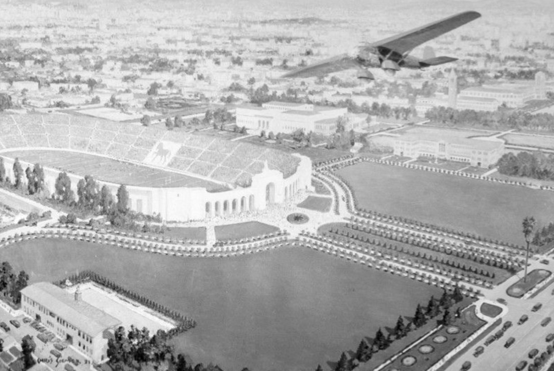
| (1930s)* - A painting by Chris Siemer of the Los Angeles Coliseum in Exposition Park around the 1930s, created for a display for the Los Angeles Chamber of Commerce. The horse created by the card section indicates that a USC football game is in progress. On the lower right side, at the Figueroa St. entrance to Exposition Park, stands the Arcade Palm. |
Historical Notes On September 5, 1914, when the Arcade Depot was replaced by a new station, the palm was transplanted to its current location in Exposition Park. This move coincided with the renaming of Agricultural Park to Exposition Park in 1913. |
 |
|
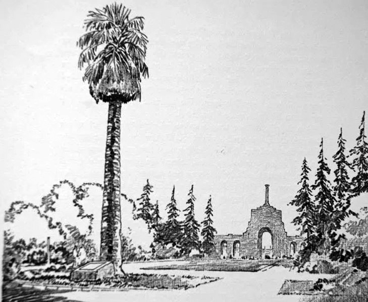
| (ca. 1938)* - Sketch of the Arcade Depot Palm with the Los Angeles Memorial Coliseum in the background. Note the plaque in front of the palm tree. Sketch by Charles Owens |
Historical Notes On September 5, 1914, when the Arcade Depot was replaced by a new station, the palm was transplanted to its current location in Exposition Park. This move coincided with the renaming of Agricultural Park to Exposition Park in 1913. |
 |
|
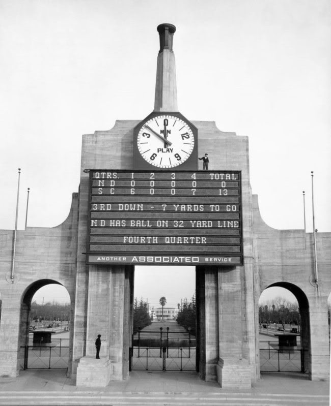
| (1932)* - View looking east at the LA Coliseum scoreboard during a USC - Nortre Dame game. The Arcade Depot Palm is seen through the arch of the colonnade. |
Historical Notes Final score: USC 13 - Notre Dame 0: USC shut out Notre Dame on its way to a second consecutive consensus national title, matching Notre Dame's feat in 1929 and 1930. From 1928-1932, USC and Notre Dame combined to win the national title five straight years, with USC winning in 1928, 1931 and 1932, and Notre Dame winning in 1929 and 1930. Click HERE to see more in Early Views of USC. |
 |
|
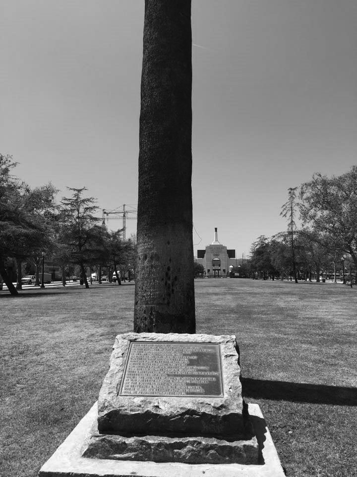
| (2018)* - View looking west toward the LA Memorial Coliseum in front of the Arcade Depot Palm and commemorative plaque. Photo courtesy of Gary Helsinger. Click HERE for another contemporary view. |
Historical Notes A plaque near the palm commemorates its history, noting its importance as a landmark and its "sentimental associations" with the city's past. |
 |
|
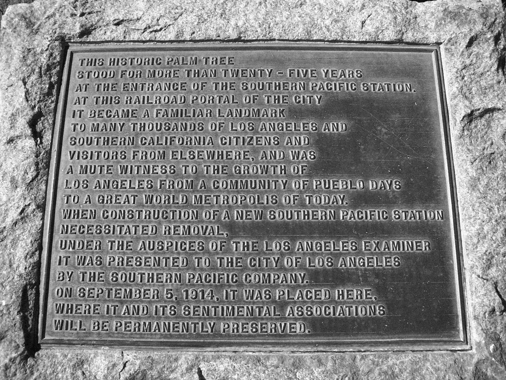
| (ca. 2010* - Plaque commemorating the Arcade Depot Palm as the "Mute witness to the growth of Los Angeles". Both plaque and Arcade Palm are situated in front of the LA Memorial Coliseum. |
Historical Notes The plaque sits in front of the Exposition Park entrance leading to the coliseum. It reads: “This historic palm tree stood for more than twenty-five years at the entrance of the Southern Pacific Station. At this railroad portal of the City it became a familiar landmark to many thousands of Los Angeles and Southern California citizens and visitors from elsewhere, and was a mute witness to the growth of Los Angeles from a community of Pueblo days to a great world metropolis of today. When construction of a new Southern Pacific Station necessitated removal, under the auspices of the Los Angeles Examiner it was presented to te City of Los Angeles by the Southern Pacific Company. On September 5, 1914, it was placed here, where it and its sentimental associations will be prmanently preserved.” |
 |
|
| (2019)* - Contemporary view of the historic Arcade Depot Palm with the Los Angeles Memorial Coliseum in the background. Photo by Seauton - Wikipedia. |
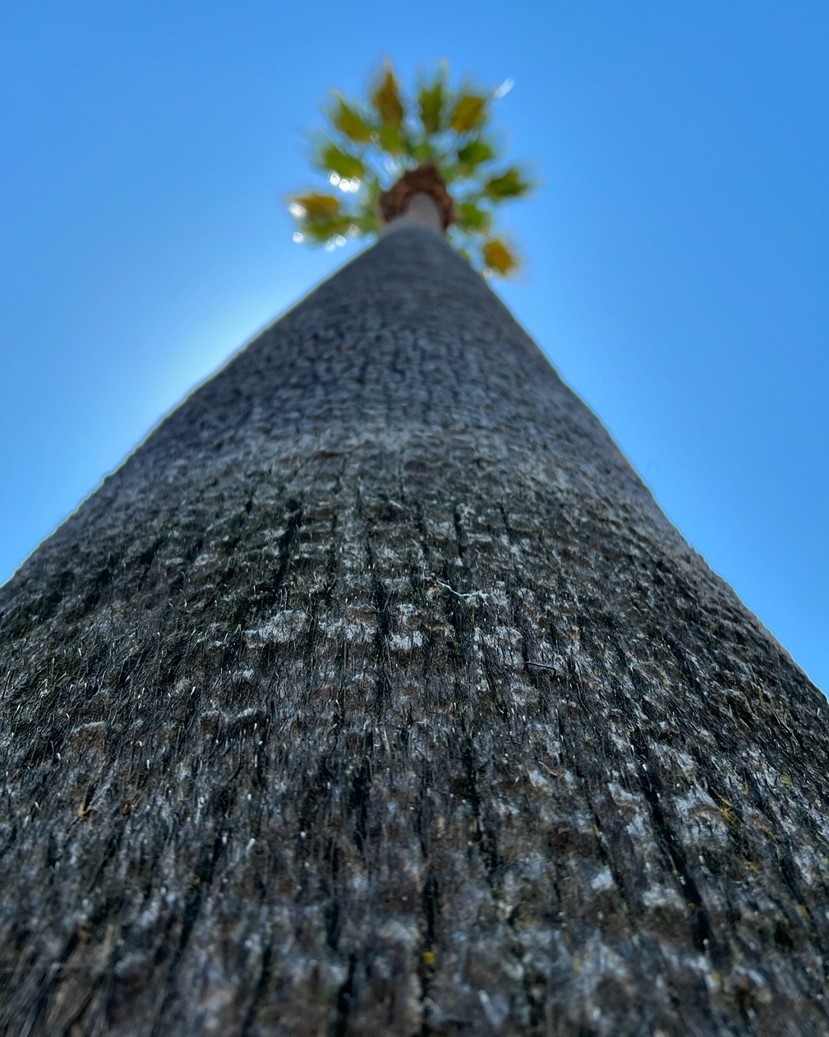
Historical Notes The Arcade Depot Palm along with the Longstreet Palms are considered to be the oldest trees in the City of Los Angeles. Despite its multiple relocations and the challenges of urban growth, including a noticeable "dent" in its trunk (possibly from the 1947-1950 drought), the palm has flourished over three centuries. |
 |
|
| (2024)* - Arcade Depot Palm - Photo by Gary Helsinger. |
* * * * * |
Banning Residence - Fort Moore Hill
 |
|
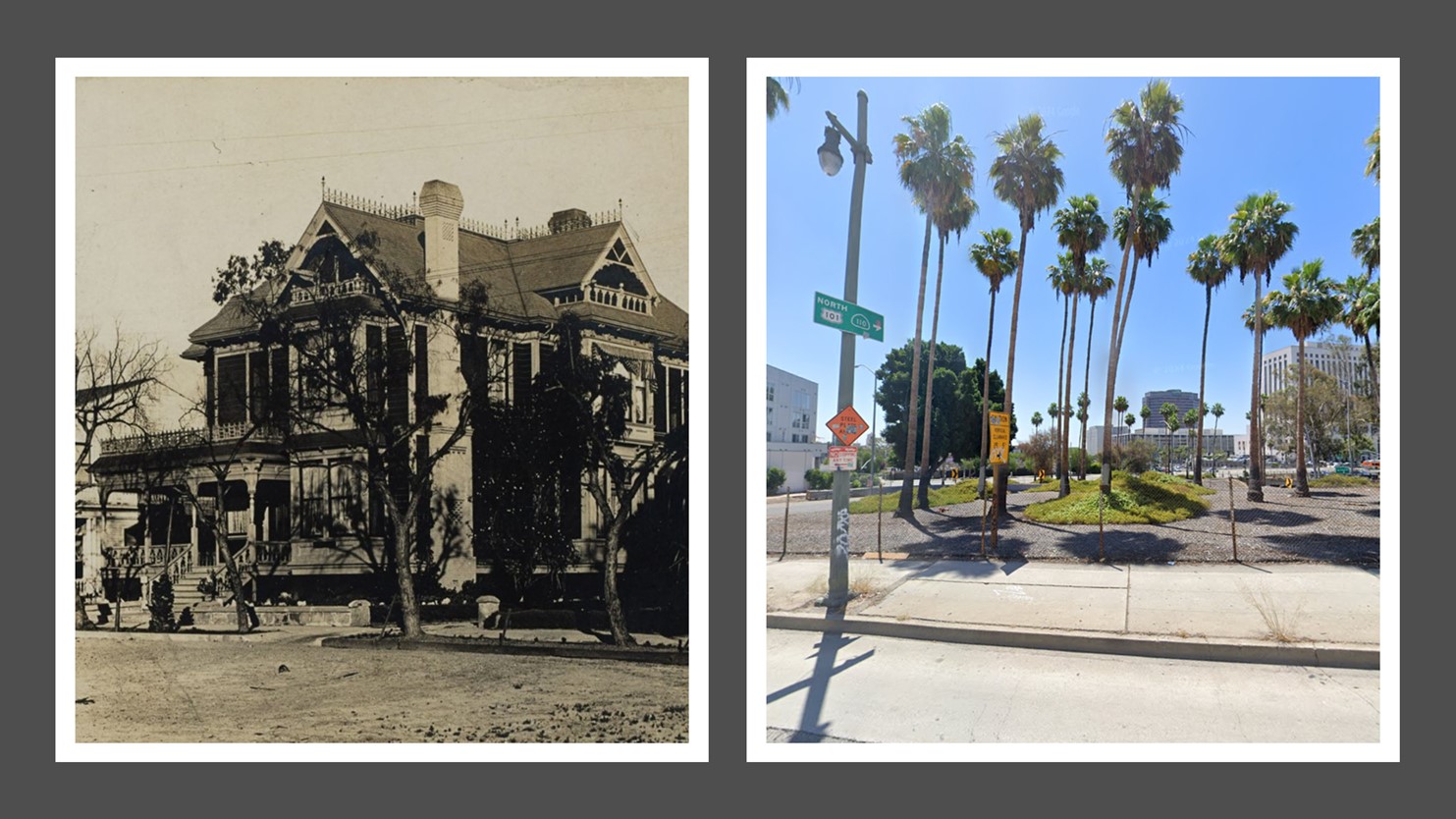
| (ca. 1887)* - View of Fort Moore Hill, showing the home (upper center) of Mary Hollister Banning, widow of General Phineas Banning. The structure was built by Jacob Philippi as a beer hall, but Banning purchased and transformed it into a home. Part of the trenches of old Fort Moore, built in 1846-1847, are visible in the upper left. |
Historical Notes Fort Moore was an historic U.S. Military Fort during the Mexican–American War. Its approximate location was at what is now the Hollywood Freeway near the intersection of North Hill Street and West Cesar Chavez Avenue, downtown. The building seen above was originally built by Jacob Philippi when he opened shop as a barkeep on Fort Moore Hill in about 1870-75. Being difficult to reach, particularly after a rain, the saloon attracted a rough crowd and after a few years of fist-,gun- and knife fights Philippi called it quits and retreated back down the hill simply boarding it up and leaving. |
.jpg) |
|
| (1888)* - Horses and buggies at the Los Angeles Plaza in 1888. The Banning Residence can be seen in the background on top of Fort Moore Hill overlooking the LA Plaza. The LA Plaza Church is to the left. Click HERE to see more in Early Plaza of L.A |
Historical Notes Following Phineas Banning's death in 1885, his widow, Mary Hollister Banning relocated from Wilmington and chose to purchase and refurbish the structure on top of Fort Moore Hill as a rather unusual home. With two strong-willed daughters in tow, particularly Lucy the younger girl whose life of misbegotten decision-making could fill a book, Mary appreciated the relative isolation as well as the view and frequent breeze the brow of the hill afforded. |
 |
|
| (ca. 1915)* - View looking west from the LA Plaza showing the Old Plaza Church with the Banning House in the background on top of Fort Moore Hill. |
 |
|
| (1927)* - View of the old Banning Residence on Fort Moore Hill, seen here as a boarding house. The structure was built by Jacob Philippi as a beer hall, but later Mary Hollister Banning, widow of General Phineas Banning, transformed it into a home. |
Historical Notes At 535 N. Broadway, here, well past its prime, now serving as a boarding house, it overlooked the north portal of the Broadway Tunnel. Interestingly, Mary's step-son Hancock Banning built his own house on Fort Moore Hill at 416 N. Broadway. It overlooked the south portal of the Broadway tunnel. |
 |
|
| (ca. 1937)* – View of the former home of Mary Hollister Banning on Fort Moore Hill. Photo by Herman Schultheis. |
Historical Notes Most of Fort Moore Hill was removed in 1949 for construction of the Hollywood Freeway. The hill was located one block north of Temple Street and a short distance south of present day Cesar Chavez Avenue, between the Los Angeles Civic Center and Chinatown. A small portion of the hill was not bulldozed and remains on the west side of Hill Street on the north side of the freeway where the fort is now memorialized by the Fort Moore Pioneer Memorial. |
* * * * * |
Hancock Banning Home (aka Fort Hill Villa)
.jpg) |
|
| (ca. 1903)* – View looking north from the top of the LA County Courthouse on Temple Street between Broadway and Spring Street showing the south portal of the Broadway Tunnel with tall flagpole on top. Above the tunnel, the first house on the right is the Victorian home of Hancock Banning (also known as Fort Hill Villa) located at 416 N. Broadway. |
Historical Notes Fort Hill Villa, a Victorian house built by Hancock Banning, was located at 416 N. Broadway on Fort Moore Hill in Los Angeles, directly overlooking the south portal of the Broadway Tunnel. This house was distinct from another residence on Fort Moore Hill—the home of Mary Hollister Banning, Hancock's stepmother. Mary Banning had converted a former beer hall, originally built by Jacob Philippi, into her residence after her husband, General Phineas Banning, passed away. Mary's home was located at 535 North Broadway and later served as a boarding house. |
 |
|
| (1905)* - Stereoscopic view of the two-story Victorian house of Hancock Banning (also known as Fort Hill Villa) at 416 North Broadway on Fort Moore Hill in downtown Los Angeles. Photo from the Ernest Marquez Collection. |
Historical Notes Fort Moore Hill itself holds significant historical value as it was originally the site of Fort Moore, a U.S. military fort established during the Mexican-American War. The hill provided strategic views over Los Angeles and played a role in the city's early development. Over time, Fort Moore Hill became a residential area, with the Banning family being notable residents. The hill was eventually reduced in size to make way for the Hollywood Freeway in 1949, leaving only a small portion of it intact, which is now commemorated by the Fort Moore Pioneer Memorial. |
 |
|
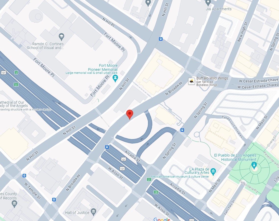
| (2024)* - Google Street View showing the site where the house of Hancock Banning (Fort Hill Villa) once stood, 416 N. Broadway. |
Historical Notes By the mid-20th century, much of Fort Moore Hill, including these residences, was removed for the construction of the Hollywood Freeway, erasing much of the area's historical landscape. |
 |
|
| (1903 vs 2024)* - The Hancock Banning House (also known as Fort Hill Villa), located at 416 N. Broadway, where today a landscaped plot of land exists adjacent to the on-ramp of the US 101 Freeway. |
 |
|
| (2024)* – Google map showing the location where the old Hancock House (aka Fort Hill Villa) once stood, 416 N. Broadway in downtown Los Angeles. |
 |
|
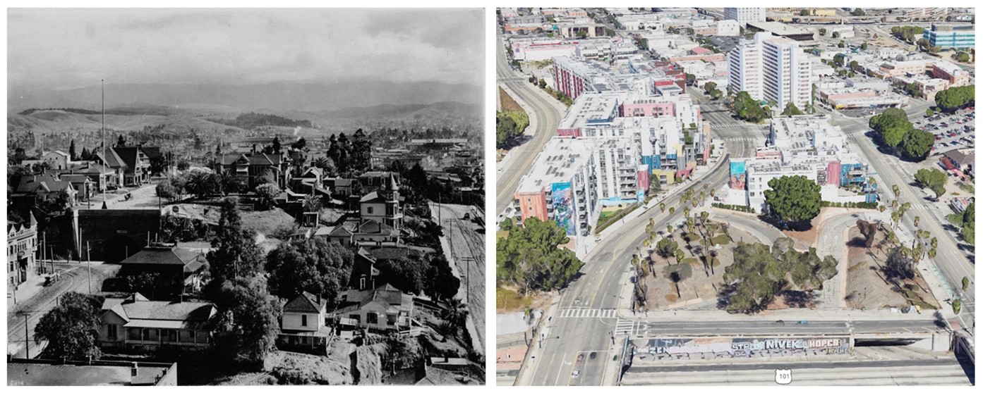
| (Then and Now)* - Then and Now - Looking north from above Temple Street in downtown Los Angeles, showing the Broadway Tunnel and Fort Hill Villa in 1903 on the left, contrasted with the modern cityscape. By the mid-20th century, much of Fort Moore Hill, including the Broadway Tunnel and Fort Hill Villa, was removed for the construction of the Hollywood Freeway, seen at the bottom of the contemporary photo, running under the Broadway and Spring Street overpasses. This development erased much of the area's historical landscape. |
* * * * * |
Los Feliz School (Cahuenga Valley - later Hollywood)
 |
|
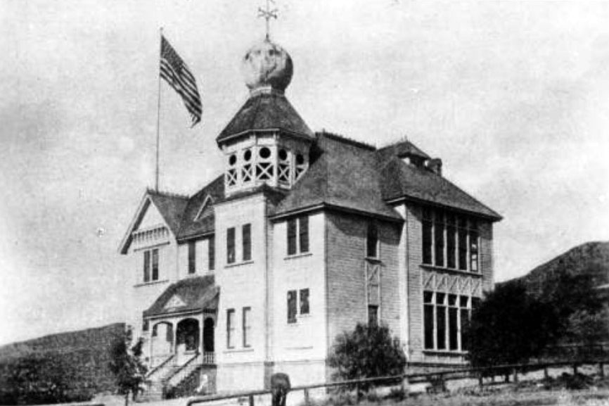
| (ca. 1887)^^* - Head of Vermont Avenue - Photograph of an exterior view of the old Los Feliz school in Cahuenga Valley, later Hollywood. The building is a two-story wood building with a large tower at center. The top level of the tower is an open deck, and the roof of the tower is onion-shaped. A tall flagpole stands on the roof at left and a large flag flies from it. The main entrance to the school is at left and consists of a stairway leading up to a covered porch. The windows of the school are tall and rectangular, and they are very close together at right. There is a hill in the background, and a low wooden fence is in the foreground. |
* * * * * |
Maclay School of Theology
 |
|
| (ca. 1887)* - Exterior view of Maclay School of Theology, a Methodist seminary founded by Charles Maclay, a Methodist minister, in 1885 in San Fernando. |
Historical Notes In 1874, Charles Maclay bought 56,000 acres of the Rancho Ex-Mission San Fernando land grant including the northern half of the San Fernando Valley. In 1882, cousins George K. Porter and Benjamin F. Porter, owner of future Porter Ranch, each received one-third of the total land. In 1885, Maclay founded the Maclay School of Theology, a Methodist seminary in his newly founded town of San Fernando, California. After his death it became an affiliate and moved to the campus of the University of Southern California before becoming the Claremont School of Theology in 1957.^* Click HERE to see Early Views of the San Fernando Valley or HERE to see Early Views of U.S.C. |
* * * * * |
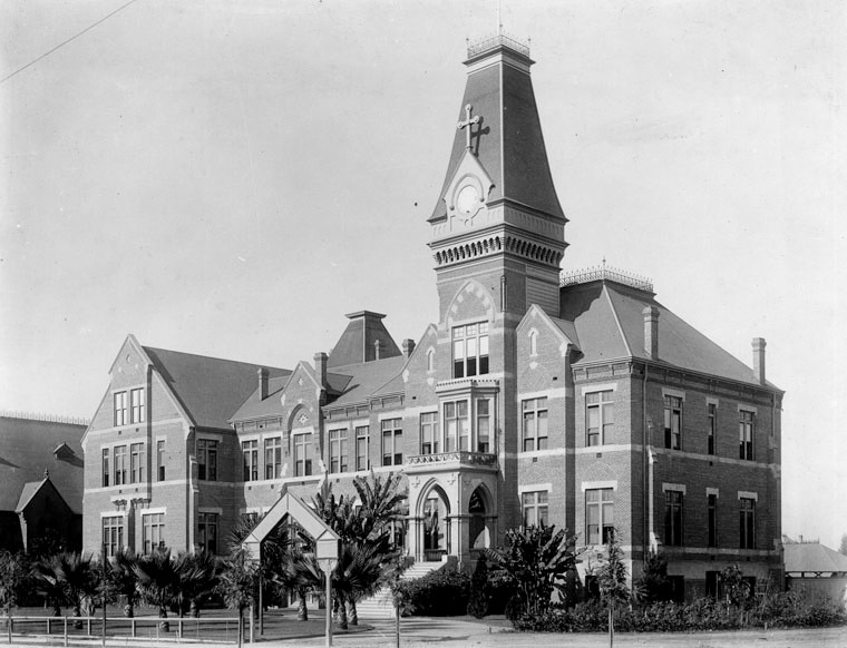
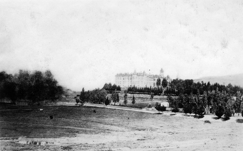
St. Vincent's College (2nd location)
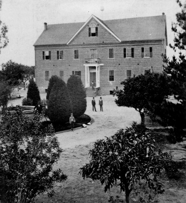 |
|
| (1866)* - View of St. Vincent's College at its second location. This would evolve to become today's Loyola Marymount University (LMU). |
Historical Notes This was St. Vincent's College second location. It first started across from the LA Plaza in a building donated by Vincent Lugo. Click HERE to see St. Vincent's College original location (Vincent Lugo Adobe). |
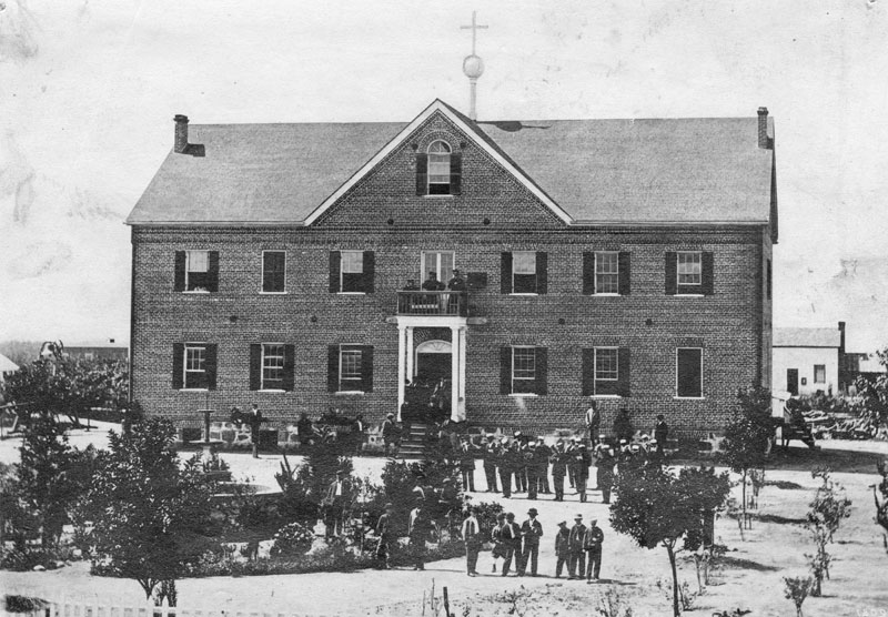 |
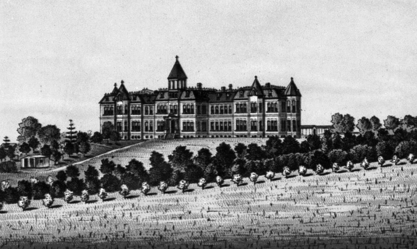
|
| (ca. 1868)* - View of St. Vincent's College, located at Hill and Broadway, between 6th and 7th streets. Numerous students, including what appears to be a band, can be seen on the grounds, which are landscaped with several trees. |
Historical Notes In 1865, the Vincentian Fathers were commissioned to found St. Vincent's College for boys in Los Angeles, and appointed John Asmuth, C.M. as its first President Rector. The college was originally located in the Lugo Adobe House at the southeast corner of Alameda and Los Angeles streets. The building was one of the few two-story complexes in the city at that time and had been donated by Vicente Lugo. Although the building no longer stands, its original site was across Alameda Street from the current Union Station on the Plaza near the southeast end of the city's historic Olvera Street. After two years, the school moved several blocks over. The campus encompassed Broadway, 6th, Hill, and 7th streets, the entire block being used for athletic fields, etc.* |
 |
|
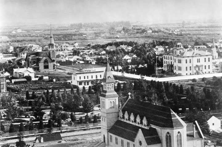
| (ca. 1884)^ - Panoramic view of St. Vincent Park (later Pershing Square) and surrounding area looking southeast. In the foreground is St. Paul's Pro-Cathedral. St. Vincent's College is seen in the upper-right. |
Historical Notes In 1867, St. Vincent's College, present day Loyola Marymount University, was located across the street, and the park informally became called St. Vincent's Park. In 1870, it was officially renamed Los Angeles Park. In 1886 it was renamed 6th Street Park, and redesigned with an "official park plan" by Frederick Eaton, later the mayor. In the early 1890s it was renamed Central Park, which it was called for decades until after World War I when it was finally named Pershing Square.^* |
 |
|
| (ca. 1887)* - View of St. Vincent's College located at Hill and Broadway, between 6th and 7th streets, showing dirt road in front of the campus. |
Historical Notes St. Vincent's College, which covered an entire block, was bounded by 6th, 7th, Fort and Hill streets. A small lane, St. Vincent's Place, ran north into campus from 7th Street.* |
.jpg) |
|
| (ca. 1887)* - View of St. Vincent's College, located at Hill and Broadway, between 6th and 7th streets. It is believed that the left portion of building was erected for St. Vincent's College, and later, was the headquarters to General Miles of the U.S. Military Dept. of Arizona. |
Historical Notes St. Vincent’s Place, the site of Saint Vincent's College from 1868 to 1887 has been designated as California Historical Landmark No. 567. The college, now Loyola University, was the first institution of higher learning in Southern California. Click HERE to see more California Historical Landmarks in LA. |
 |
|
| (1889)* - Southwest headquarters of the United States Army, formly the site of Saint Vincent's College, Sixth Street and Broadway. |
Historical Notes Today, the site is in the heart of Los Angeles's Jewelry District and is known as St. Vincent Court. A decade later, the school moved to a location at Grand Avenue and Washington Boulevard where it remained until being folded into the newly founded Los Angeles College in 1911.^* |
 |
|
| (1905)* - Front view of St. Vincent's College (now Loyola Marymount University) on South Grand Avenue, between W. 18th Street and W. Washington Boulevard. This was the third campus location. |
Historical Notes Rapid growth of St. Vincent College enrollment prompted the Jesuits to seek a new campus on Venice Boulevard in 1917. In 1918, the name was changed to Loyola College of Los Angeles. The school relocated once again to the present Westchester campus in 1929, and achieved university status in 1930, becoming Loyola University of Los Angeles. In 1973, Loyola University and Marymount College merged to form Loyola Marymount University (also known as LMU).* |
* * * * * |
Los Angeles Infirmary
 |
|
| (1881)* - Photograph of the Los Angeles Infirmary, as it looked in 1881. This was the second building to house the city's finest hospital, located on Naud Street, opposite the Southern Pacific Railroad Depot. This was a three-story American Mansard-style structure with a wrap-around balcony on the second floor, and numerous windows and doors. Two young girls stand next to a large shrub at the front of the hospital, and several adults stand on the balcony. |
Historical Notes The Daughters of Charity of St. Vincent de Paul established the first hospital in Los Angeles - the Los Angeles Infirmary, in 1856. It was located in the Sonora Town adobe owned by then-Mayor of Los Angeles, Don Cristóbal Aguilar. Four years later, in 1860, the hospital relocated to 1416 Naud Street, between Ann (named for Sister Ann) and Sotillo Street (though other data indicates the location was 1414 Naud Street, between N. Main and San Fernando Road). In 1869, Daughters incorporated the Los Angeles Infirmary under their own ownership, the first women in the region to do so. By 1898, Los Angeles Infirmary had come to be known as Sisters Hospital, but both names were used interchangeably in reference to the same hospital.* |
* * * * * |
St. Vincent's Hospital (aka Sisters Hospital)
 |
|
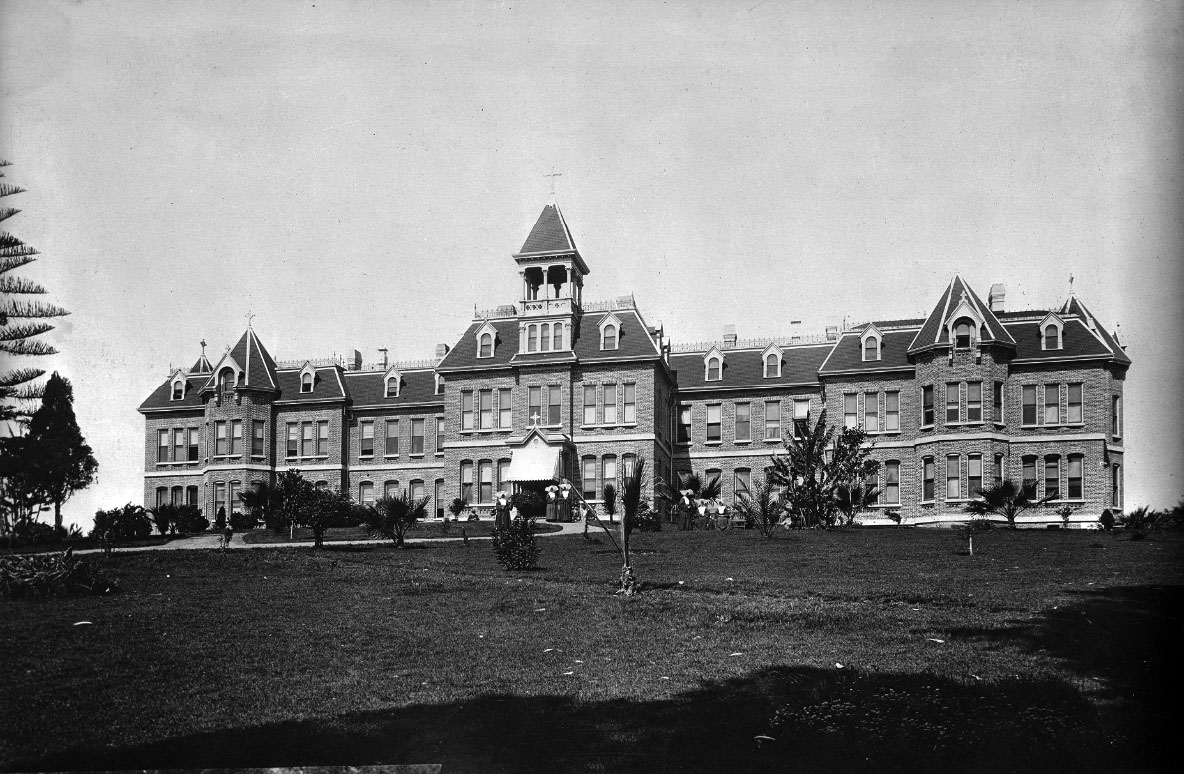
| ca. 1887)* - View looking northwest showing St. Vincent's Infirmary (aka Sisters Hospital) located near Sunset Blvd and Beaudry Ave as seen from across a sparse field. Several trees can be seen to the right of the grand hospital, which boasts of numerous windows, dormers, an irregular roof, a cupola or tower, and several chimneys. |
Historical Notes In 1883 the Daughters of Charity of St. Vincent de Paul purchased six and a half acres of land at Beaudry Park at a cost of $10,000, and a new hospital building was erected a year later at Beaudry and Sunset, on a hillside overlooking Sonora Town. By 1898, Los Angeles Infirmary had come to be known as Sisters Hospital, but both names were used interchangeably in reference to the same hospital.* |
 |
|
| (1880s)* - Lithograph sketch showing St. Vincent's Hospital located on a well-landscaped hill that was originally called Beaudry Park. |
Historical Notes Beaudry Park was purchased in 1883 by the Sisters of Charity. On that site (now occupied by The Elysian apartment building and Holy Hill Community Church) the sisters placed their new infirmary, repurposing Beaudry's fruit trees and cypresses into a soothing backdrop for their patients.* |
 |
|
| (ca. 1887)^^* - Photograph of St. Vincent's Hospital (aka Sisters Hospital) as seen from across the lawn. Several trees, most of them palms, are planted in front of the grand hospital that shows numerous windows, dormers, an irregular roof, a cupola or tower, and several chimneys. Six nuns can be seen walking and/or sitting around the front lawn. |
Historical Notes The Daughters of Charity of St. Vincent de Paul established the first hospital in Los Angeles - the Los Angeles Infirmary, in 1856. It was located in the Sonora Town adobe owned by then-Mayor of Los Angeles, Don Cristo´bal Aguilar. Four years later, in 1860, the hospital relocated to 1416 Naud Street, between Ann (named for Sister Ann) and Sotillo Street (though other data indicates the location was 1414 Naud Street, between N. Main and San Fernando Road). In 1869, Daughters incorporated the Los Angeles Infirmary under their own ownership, the first women in the region to do so. In 1883 they purchased six and a half acres of land at Beaudry Park at a cost of $10,000, and a new hospital building was erected a year later at Beaudry and Sunset, on a hillside overlooking Sonora Town. By 1898, Los Angeles Infirmary had come to be known as Sisters Hospital, but both names were used interchangeably in reference to the same hospital. |
 |
|
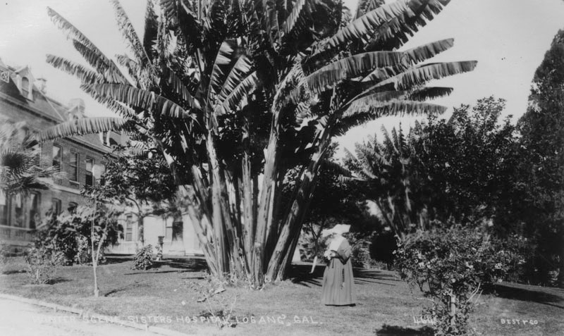
| (ca. 1890s)* - View of Sisters Hospital (aka St. Vincent's Hospital) as seen from behind a cluster of banana trees located on the grounds; a nun can be seen standing in the foreground. More trees hide the rest of the grand hospital, which boasts of numerous windows, dormers, an irregular roof, a cupola or tower, and several chimneys. |
Historical Notes Sisters Hospital (originally St. Vincent's Infirmary) was built in 1884 on six and half acres of what was then known as Beuadry Park (developed by brothers Prudent and Victor Beaudry in 1876). The area today is called Victor Heights. |
 |
|
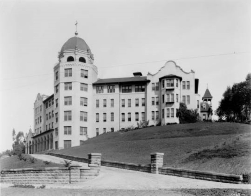
| (ca. 1910)^^* - View of Sisters Hospital near Sunset and Beaudry. A new seven-story octagonal tower topped with a dome rises on the corner of the four-story Mission-revival building. A cross is on top of the dome. The original building with its unique cupola can be seen at center-right. |
Historical Notes In 1913 the Los Angeles Infirmary became the first hospital in California accredited by the American College of Surgeons. #^#^ |
 |
|
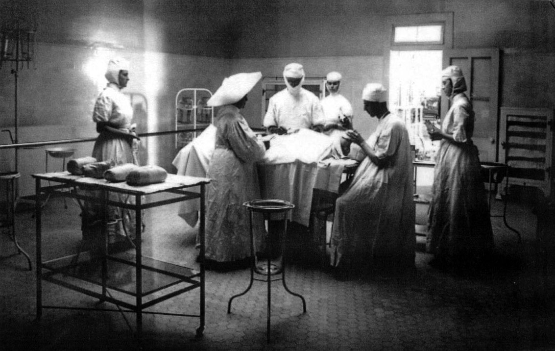
| (1908)^^* - Interior view of the Los Angeles Infirmary (later, Saint Vincent's Hospital), Sunset and Beaudry. A group of six nurses and doctors surround a patient on an operating table. |
Historical Notes In 1918, the name was officially changed to St. Vincent's Hospital. In 1924 a new building was erected on 3rd and Alvarado, which was built by John C. Austin and Frederick M. Ashley. For 47 years, the hospital had such a steady growth that they were forced to expand yet again, and groundbreaking for a newer, larger building took place in 1971 - this time, located at 2131 W. 3rd Street. With a "new" hospital came a new name, and in 1974, it changed again, this time becoming St. Vincent Medical Center. Click HERE to see more on the new 1924-built St. Vincent Hospital. |
* * * * * |
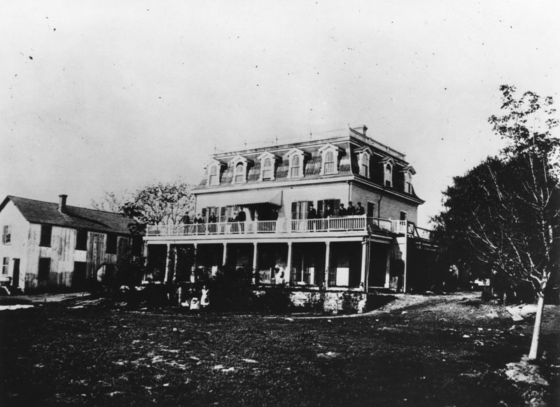
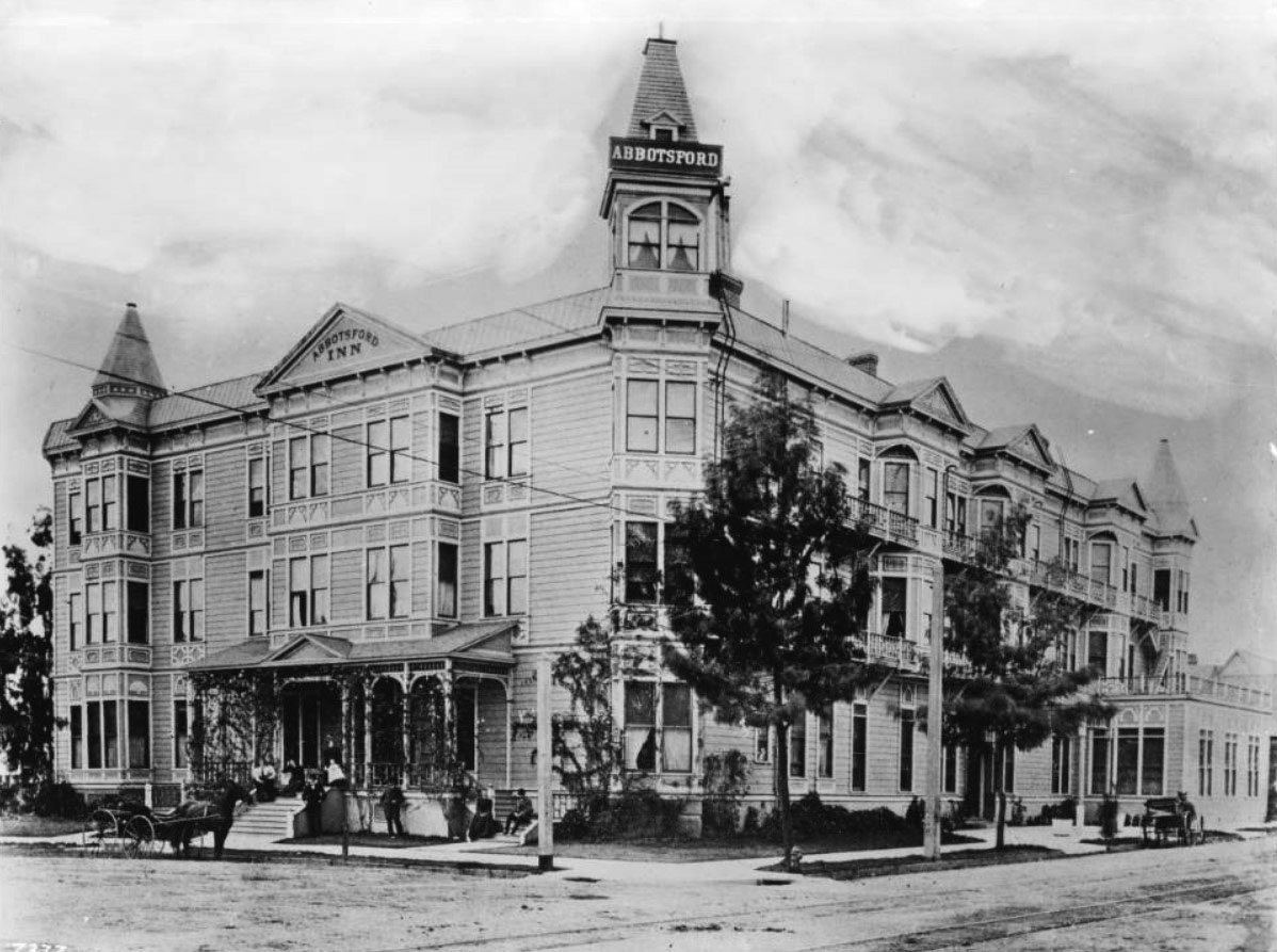
Los Angeles College for Young Ladies (later Abbotsford Inn)
 |
|
| (ca. 1887)* - View of Los Angeles College, located on the southwest corner of Eighth and Hope streets. Photograph shows a three-story wooden building with jutting towers on each corner, narrow fire-escapes on the second and third floors along the right side of the building, and numerous windows throughout the entire structure. A low fence and hedge surrounds the college. |
Historical Notes Rev. D.W. Hanna, one of the pioneer educators of Los Angeles, opened the Los Angeles College for Young Ladies, better known as Hanna College, on September 2, 1885. At the time, it was the only institution in the city that provided exclusively for the higher education of young women. The school was originally located in a couple of buildings on the corner of Fifth and Olive streets. By 1887, having formed a stock company, Hanna erected a new, larger school structure on the southwest corner of Eighth and Hope streets. With 350 students enrolled at that time, the college prospered and was a popular girls' boarding school, where many of the most exclusive families sent their daughters to be educated. Sadly, Hanna's own daughter died in 1892, and he never fully recovered from the loss; he gave up his teaching work and went into retirement due to poor health, and shortly after, the institution failed. A few years later, Abbot Kinney purchased the still standing building.* |
Abbotsford Inn
 |
|
| (ca. 1903)^^* - View showing the Abbotsford Inn, previously the Los Angeles College for Young Ladies, located on the southwest corner of Eighth Street and South Hope Street. People are posed along the porch to the left of the inn, in front of a horse-drawn carriage parked along the sidewalk. The street shows streetcar rails embedded in it. |
Historical Notes Circa 1900, Abbot Kinney, best known as the developer of Venice, purchased the Los Angeles College for Young Ladies after it failed and operated it as the 100-room Abbotsford Inn. In 1914, First Methodist Church purchased the property; in 1921 the structure was demolished to make way for a new church building.* |
* * * * * |
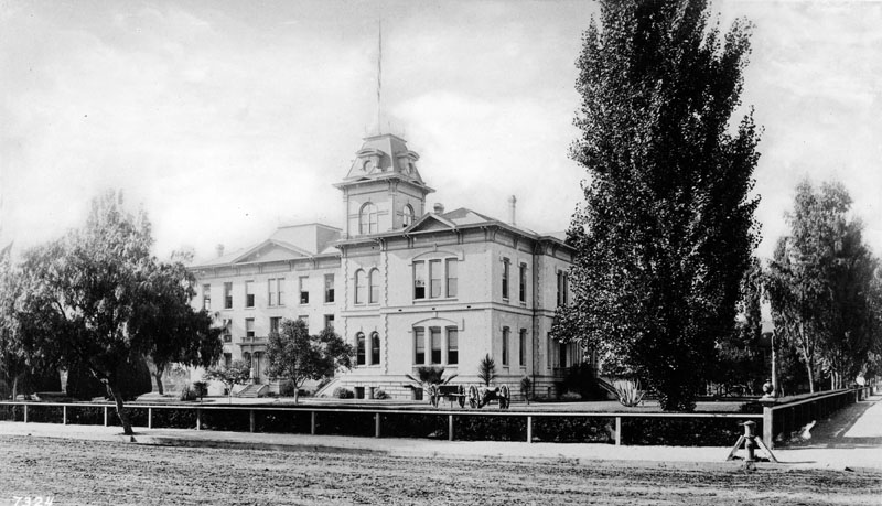
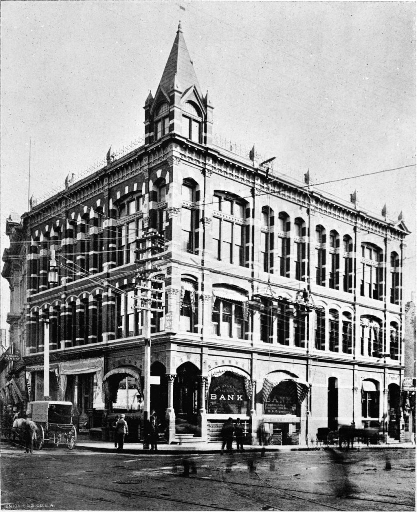
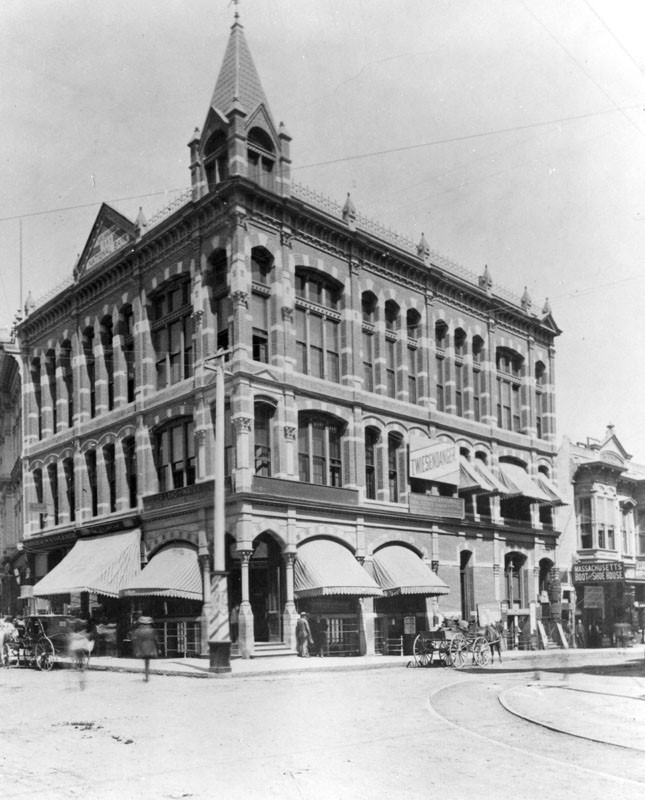
Los Angeles National Bank Building
 |
|
| (ca. 1887)^^* - View of the Los Angeles National Bank building on the northeast corner of 1st and Spring Street where City Hall is today. |
Historical Notes Completed in 1887, the building was designed by Kysor & Morgan in the "Modern Gothic" style, includes a basement and cost $65,000 to build. The building materials were granite, iron and pressed brick. The bank was organized in 1883 and later merged, along with Southwestern National Bank, with First National in 1905.* The Masonic Temple was located upstairs and the Shriners had their first meeting hall here in 1888.^^* |
 |
|
| (ca. 1890)* - View of the Los Angeles National Bank at the northeast corner of First and Spring streets, in downtown Los Angeles. |
Historical Notes In 1906, the seven-story Equitable Savings Bank replaced the Los Angeles National Bank building on the northeast corner of First and Spring streets.^ |
* * * * * |
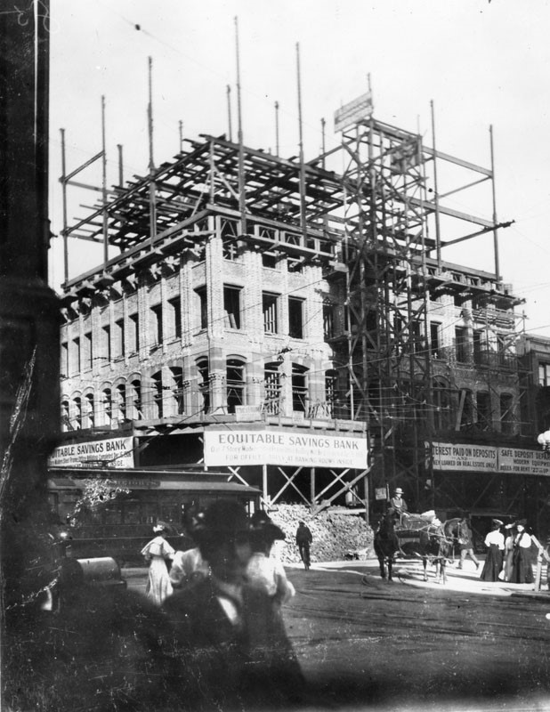
Equitable Savings Bank
 |
|
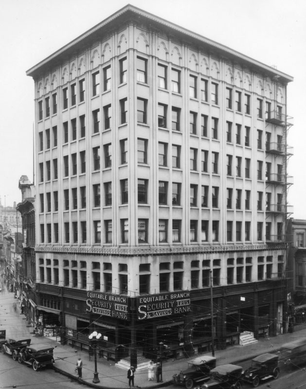
| (1906)* - View of the construction of Equitable Savings Bank, a seven-story structure that replaced the Los Angeles National Bank building at the northeast corner of 1st and Spring. |
 |
|
| (1920)s* - Exterior view of Security Trust and Savings Bank at First and Spring Streets, in the Equitable Building. |
Historical Notes The Equitable Savings Bank Building did not last too long, being demolished in the late 1920s. The site today is the corner of the park next to City Hall.^ |
 |
|
| (2014)#^** – View looking at the northeast corner of Spring and First Streets where the Equitable Bank Building once stood, now a park next to City Hall. |
* * * * * |
O'Melveny Residence
 |
|
| (ca. 1880s)* - The southwest corner of Broadway and 2nd St., showing the house built in 1870 for Judge O'Melveny. |
Historical Notes In 1887 the house was moved around to make way for the American National Bank. In 1911 the California Building was erected on the spot.* |
* * * * * |
Brunson Mansion
 |
|
| (ca. 1880s)* - Exterior view of the Brunson Mansion, located at 347 S. Grand Avenue on Bunker Hill. |
Historical Notes The home was built in the early 1880s by Judge Anson Brunson who resided on the bench of the Los Angeles County Superior Court before stepping down to serve as a lawyer for the lucrative Santa Fe Rail Road.* |
 |
|
| (ca. 1880s)* - Front view of the Brunson Mansion on Bunker Hill. Note the man standing on the lawn in front of the house. |
Historical Notes The Brunson Mansion at the corner of Fourth Street and Grand Avenue was an imposing structure that seemed destined to stand indefinitely. Instead it would last less than four decades and become an early victim of the City's obsession with the automobile. According to the L.A. Times, the residence was “a dark red house, large, compact, dignified, in the center of sloping lawns walled up above the level of three streets.” The house was so large it had a Bunker Hill Avenue and a Grand Avenue address, before settling on 347 South Grand as its official label.^ |
 |
|
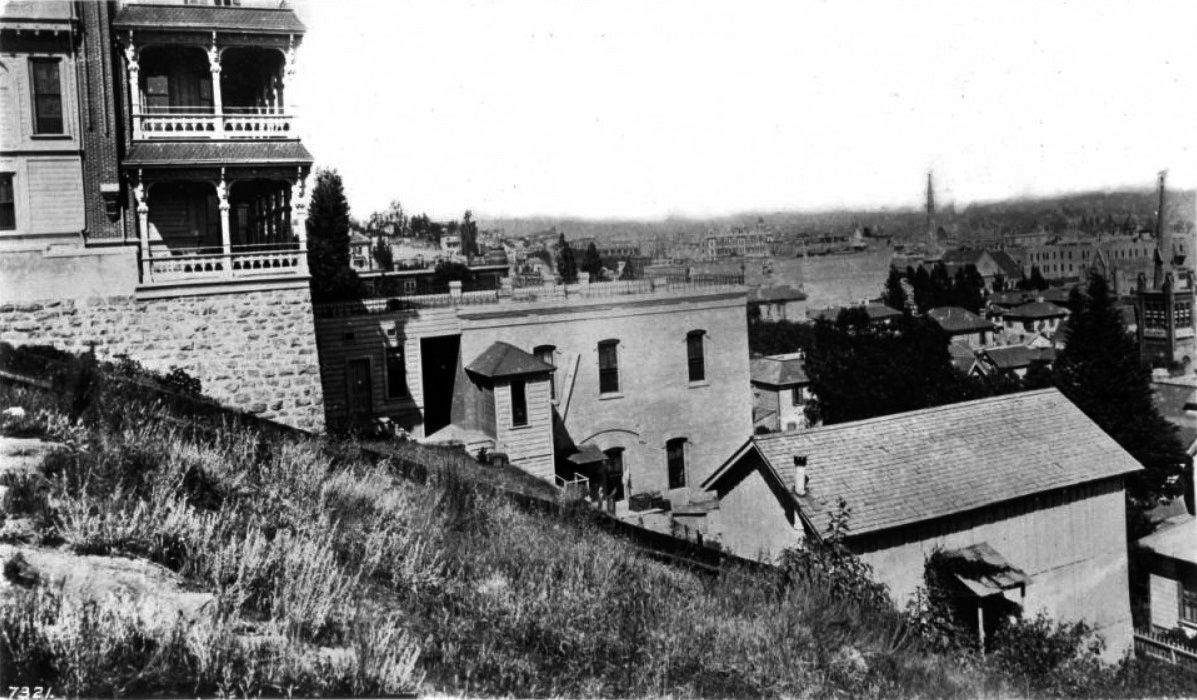
| (ca. 1890)* – View looking west toward Bunker Hill showing the impressive Brunson Mansion at center-right with the Rose Mansion at far left. Note the 150-ft tall streetlight at center-left. Click HERE to see more Early Views of LA Streetlights. |
Historical Notes At the turn of the century, the 18 room property became the Hotel Brunson and would remain a boarding house for thirteen years. By 1917, the automobile had come to Bunker Hill and the owners of the property at 347 South Grand decided that a two story brick garage would be more lucrative than a hotel. In April of that year, the furnishings of the Brunson Hotel were auctioned off, and the stately structure which was once a “show place of the city” was demolished and replaced by an auto mechanic. |
* * * * * |
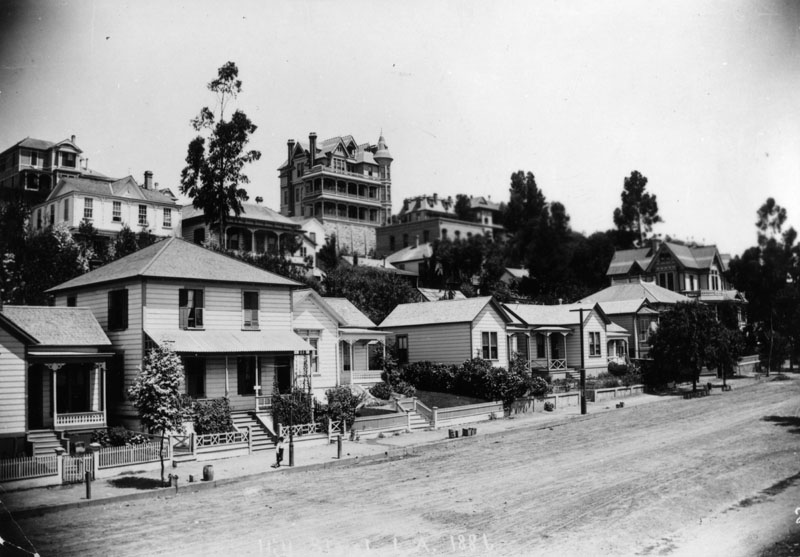
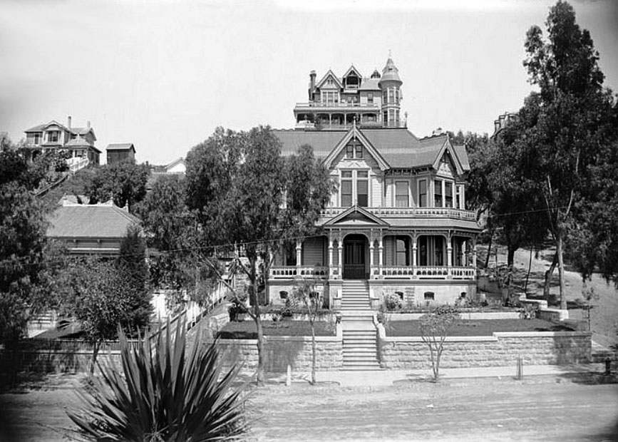
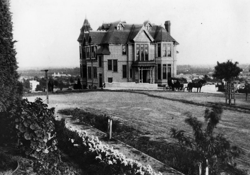
Crocker Mansion
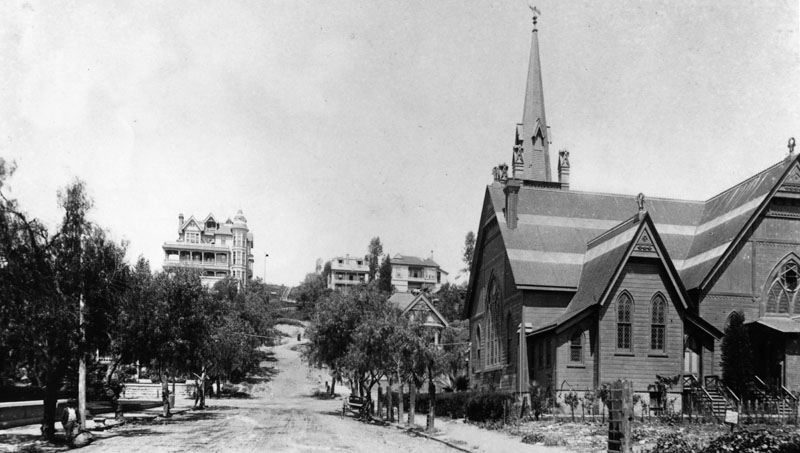 |
|
| (ca. 1885)^ - View of Bunker Hill, looking west from 3rd and Hill streets. On the right is the First Congregational Church, built in 1883. It later became the Central Baptist Church and then the Unitarian Church. The Crocker Mansion is seen in the background. |
Historical Notes At the turn of the 20th Century, no building dominated Bunker Hill like the Crocker Mansion. Perched high at the corner of Third and Olive, the imposing 3-story Victorian structure overlooked the emerging metropolis for more than 22 years. |
 |
|
| (ca. 1885)* - View of Bunker Hill, looking west from 3rd St. and Hill. On the right is a closer look at the First Congregational Church, built in 1883. The Crocker Mansion, located at 3rd and Olive, was later called the Crocker Mansion Rooming House became the site of the Elks Club (later the Moose Lodge). |
Historical Notes By 1901, city and private engineers would come up with two different ways to traverse the steep hill...they built an 1080-foot long tunnel and a 33-percent grade funicular at the intersection seen above. |
 |
|
| (1886)^ - View of Bunker Hill from Hill and 3rd looking northwest. The Crocker Mansion, located at 3rd and Olive, can clearly be seen at the top of the hill. |
 |
|
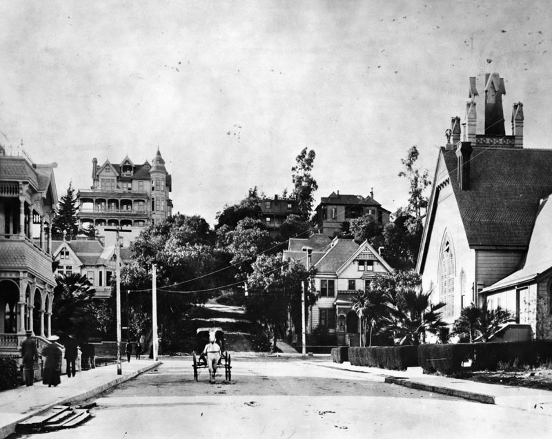
| (ca. 1990)* - The Crocker Mansion (upper center, 300 South Olive Street, later BPOE Temple), viewed from the corner of Third Street and Hill Street in Bunker Hill. The image showcases the Queen Anne style house on the upper part of the hill, featuring a multi-windowed corner tower, verandas, a balcony set into the roof, and an English chimney. In the foreground, there is a lawn with a Fan Palm tree and an unidentified Victorian house. Photo by C. C. Pierce. |
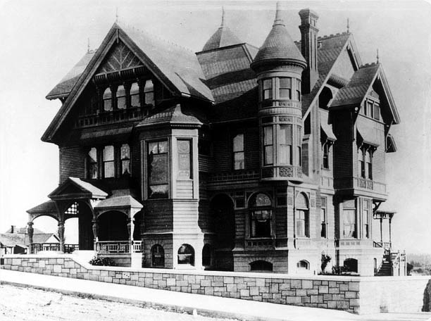
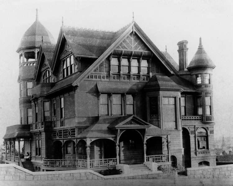
Historical Notes The Crocker Mansion, located at 300 South Olive Street, was one of the most notable residences in Bunker Hill. Built in 1886 by Margaret E. Crocker, the widow of California Supreme Court Justice Edwin Bryant Crocker, the mansion was an imposing three-story Victorian structure designed by architect John Hall. Margaret Crocker was a prominent social and civic leader, known for her philanthropy, including the donation of the family's art collection to the city of Sacramento. The mansion's history is marked by both grandeur and scandal. In 1887, it became the center of a high-profile kidnapping case when Margaret Crocker's granddaughter, Alma Ashe, was taken by her father, Robert Porter Ashe, amidst a contentious divorce. Despite such dramatic events, the mansion remained a symbol of elite society in Los Angeles. In 1891, the Crocker Mansion was converted into a boarding house, which was still considered more luxurious than the typical rooming houses on Bunker Hill at the time. However, the construction of the Third Street Tunnel in 1900 compromised the mansion's structural integrity, leading to its eventual demolition in 1908 to make way for new development. |
 |
|
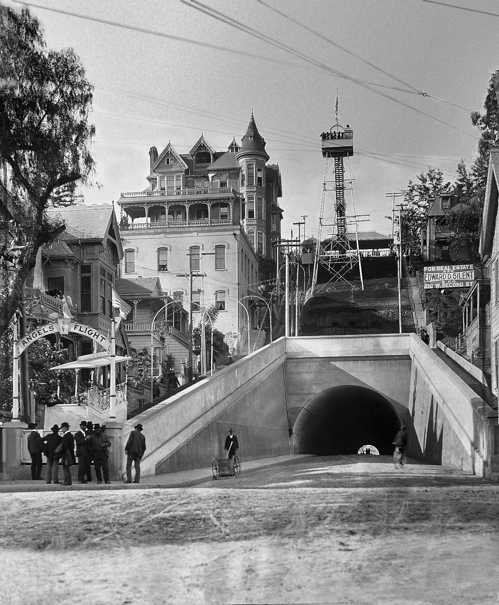
| (1895)* – View looking west at 3rd and Hill Streets with the Crocker Mansion seen at the top of Bunker Hill. The southwest corner of 3rd and Hill (lower-right) would become the lower station terminal of Angels Flight. |
 |
|
| (ca. 1887)* - The Crocker Mansion, located on the south east corner of 3rd and Olive street. This photo shows the back entrance of the mansion, as well as a horse-drawn carriage with three women and a child taking in the spectacular views of Downtown Los Angeles. |
 |
|
| (ca. 1888)* - Looking across an unpaved Olive Street, just south of 3rd Street, towards the Crocker Mansion on Bunker Hill. |
 |
|
| (ca. 1890)* - Partial view of the Crocker Mansion looing northeast showing its brick foundation, porch and balcony. |
 |
|
| (ca. 1890)* - Rear view of the Crocker Mansion showing the full extent of its wide balconies where you could get a great view of the emerging metropolis of Los Angeles. |
 |
|
| (1898)* - Panorama view from 3rd and Spring streets showing the Crocker Mansion and neighbors on Bunker Hill. |
Historical Notes Construction on the Third Street Tunnel began in 1900, and Mrs. Crocker filed a petition claiming that the mansion was endangered by the street tunnel which was “unsafe, improperly constructed and a veritable death trap.” According to the Los Angeles Times, “the walls of her house are settling, the foundations giving way and the plaster is falling off…Unless something is done, the building is liable to topple into a hole.” The house never did topple and was alive and well in 1902 when Angels Flight began operating and dropping riders off practically on the Crocker doorstep. |
 |
|
| (ca. 1894)* - Panoramic view of downtown Los Angeles from the Crocker Mansion (partially visible at left) looking east on Third Street from the intersection of Olive Street on Bunker Hill. Flags are flying on several buildings, including the Bradbury Building (Third Street and Broadway). The Los Angeles City Hall, with its distinguished tall tower, is seen just to the right of the mansion. Photo by C. C. Pierce. |
 |
|
| (1901)* - 3rd Street, looking west, with a close-up view of a streetcar near the recently completed 3rd Street Tunnel in Bunker Hill. The Crocker Mansion stands tall at the top of Bunker Hill. |
Historical Notes On July 3, 1893, residents and taxpayers presented a petition to the Los Angeles City Council asking that a tunnel be created to connect those who lived in the Crown Hill neighborhood with the business district located on this side of Bunker Hill. Their plans called for a tunnel 1080 feet long, with a twenty-six foot roadway and eight foot sidewalks. Nothing happened for five years. In 1898 the City Council ordered the City Attorney to draw up an ordinance putting tunnel bonds in front of the public via a special election. That election was held on July 6, 1898, and funds were approved for both the Third Street and Broadway tunnels. On January 21, 1900, a serious disaster struck. Thirteen men were "entombed" in the tunnel dig after a massive cave-in on the western end. Several were killed in the collapse, but others were trapped inside with only the air in the tunnel. Frantic efforts were made to dig into their position. Ten men were rescued, while three perished. In March of 1901 the tunnel was opened to the public. It was unpaved and unlit. Gutters weren’t installed until 1902. Angel's Flight would open within a year of completion of the 3rd Street Tunnel. |
 |
|
| (1901)* - Photo of Angels Flight at the grand opening of the incline railway, December 31st, 1901. An observation tower was also constructed on top of the hill adjacent to the Crocker Mansion. |
Historical Notes The Victorian Crocker Mansion was razed in June 1908 and the cornerstone for the Elk’s Annex was laid the following September. Built in 1901 with financing from Colonel J.W. Eddy, as the Los Angeles Incline Railway, Angels Flight began at the west corner of Hill Street at Third and ran for two blocks uphill (northwestward) to its Olive Street terminus. Click HERE to see more Early Views of Angels Flight. |
* * * * * |
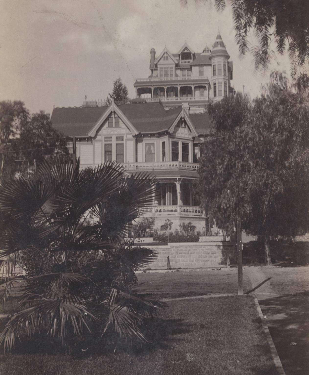
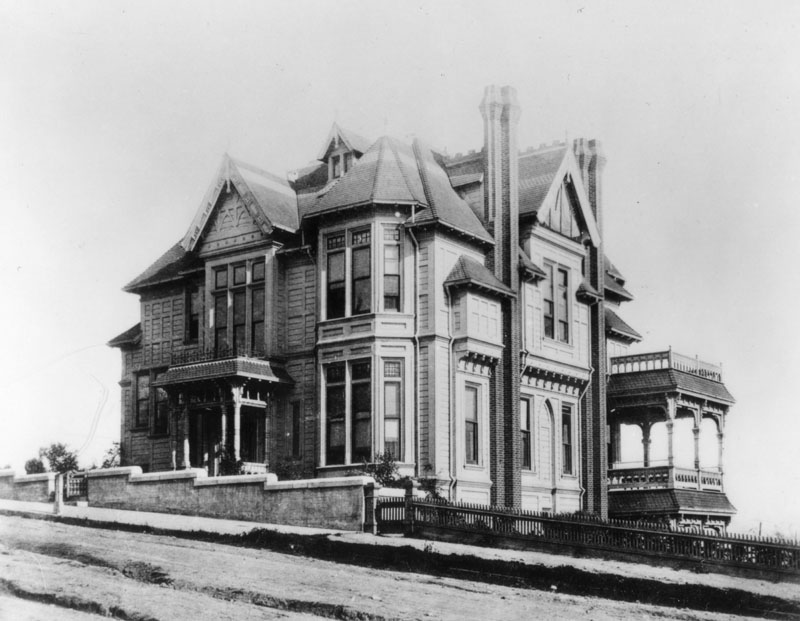
Rose Mansion
 |
|
| (1888)*##^ - Exterior front corner view of the Leonard John Rose Victorian home at 400 South Grand Avenue. |
Historical Notes Sunny Slope was the name of the renowned ranch Rose acquired shortly after arriving in Southern California in 1860. Located in what is now the eastern end of Pasadena, the 1,900 acre property contained countless lemon, orange and olive trees, but became famous for its vineyards. Vines were imported from Spain, Italy and Peru, and the wine and brandy generated from Sunny Slope made L.J. Rose a household name and a very wealthy man. He also found success as a breeder with a horse ranch named Rosemead (where the city of the same name now stands), and eventually became a State Senator.^ |
 |
|
| (ca. 1890)* - Exterior of the mansion owned by businessman Leonard John Rose, located on the southeast corner of Grand Avenue and 4th Street on Bunker Hill. |
Historical Notes The lavish home, completed in 1888, was designed by Curlett & Eisen and cost approximately $50,000 to build.* |
* * * * * |
Larronde Mansion
 |
|
| (ca. 1888)* - Exterior front corner view of the three-story Victorian style home of Pierre Larronde at 237 N. Hope Street, Bunker Hill. |
Historical Notes At one time, the name Larronde was a fairly well known one in the City of Angels. Pierre Larronde was a native Frenchman who landed in San Francisco in 1847 and made a killing in the gold mines. When he relocated to Los Angeles in 1851, he amassed a further fortune by successfully raising sheep on one of the Ranchos. Always the astute businessman, Larronde cashed out his sheep empire in the late 1880s and focused his energies on real estate. His holdings included prime land at the corner of First and Spring, and a parcel on North Hope Street near Temple where he built the family home. The Sanborn Fire Insurance maps show the house on Hope Street as being under construction in 1888. The Larronde Bunch moved in shortly thereafter and held gatherings on a regular basis that made the society pages. Unlike many residences of Bunker Hill, the Larronde home suffered no scandals or controversies. Pierre the pioneer died in 1896, around the age of 70, and Juana resided on Hope Street until her death in 1920 at the ripe old age of 84.^ |
 |
|
| (1954)* - Exterior of the Queen Anne Revival style home, located at 237 N. Hope Street. It was demolished in 1957. |
Historical Notes Pierre Larronde had a great deal in common with a fellow Los Angeles pioneer named Jean Etchemendy. Both men hailed from a south western region in France called the Basses-Pyrenees, both briefly lived in South America before cashing in early on the Gold Rush, and both successfully settled in Los Angles as sheep ranchers. Last but not least, both men married a gal named Juana Egurrola. Juana was born in Marquina, Spain but moved to California with her family at a very young age. She married Etchemendy in 1865 and gave birth to daughters Mariana, Madeleine and Carolina. Jean Etchemendy died in 1872 and Juana mourned for a couple of years before hooking up with the other French sheep-man in town. Juana’s 1874 union with Pierre Larronde produced three children, Pedro Domingo, John and Antoinette. For nearly eighty years, one family resided in the house at 237 North Hope Street. By the end of the 1960s, all traces of the Larronde/Etchemendy clan were erased from Bunker Hill.^ |
* * * * * |
Hazard's Pavilion
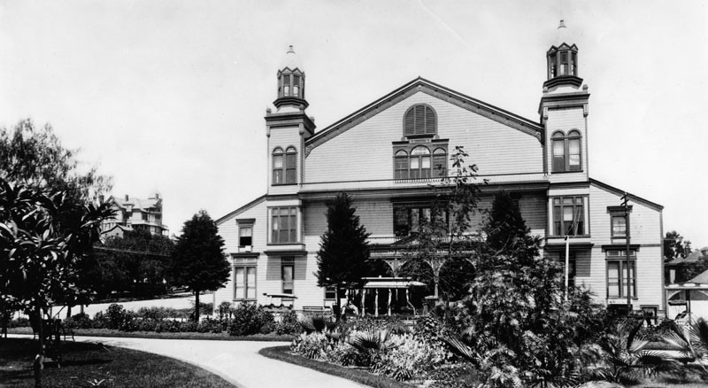 |
|
| (ca. 1887)* - Exterior view of Hazard's Pavilion. Erected in early-mid 1880; demolished around 1905, it is the present site of the Philharmonic Auditorium. |
Historical Notes Hazard's Pavilion was a large auditorium located at the intersection of Fifth and Olive Streets. Showman George "Roundhouse" Lehman had planned to construct a large theatre center on the land he purchased at this location, but he went broke and the property was sold to the City Attorney (and soon to be Mayor), Henry T. Hazard. The venue was built in 1887 at a cost of $25,000, a large amount for the time, and seated up to 4,000 people (some sources say that seating could be up to 8,000; the building was divided into two galleries, and perhaps each accommodated 4,000). The building was constructed of wood with a clap-board exterior, and the front was framed by two towers.^* |
 |
|
| (1903)* - A public reception being held inside the Hazard's Pavilion in May 4, 1903. The pavilion was erected in 1887 and demolished around 1905. The Philharmonic Auditorium was built in its place. |
Historical Notes As the largest building of its type in Los Angeles at the time, Hazard's Pavilion was a venue for conventions, political meetings, lectures, fairs, religious meetings, concerts, operas, balls, and sports events. It opened in April, 1887 with a modest civic flower festival, but a month later it hosted the National Opera Company with 300 singers, ballet dancers, and musicians. The Pavilion hosted regular religious meetings, including a series in 1888 where famed evangelist Dwight L. Moody spoke. In attendance at one of these meetings was Harry A. Ironside, which led him to becoming a world-famous preacher in his own right. Booker T. Washington, William Jennings Bryan and Carrie Nation were among the famous people who spoke to crowds gathered at Hazard's Pavilion. The great Italian operatic singer, Enrico Caruso, performed there.^* |
 |
|
| (1895)* - Hazard's Pavilion as seen from across the street. Location: Intersection of 5th and Olive Streets. |
Historical Notes From 1901 to 1904, the first great Los Angeles boxing promoter, Uncle Tom McCarey, staged his first boxing shows at the pavilion. It would be McCarey who put the Los Angeles area on the map as a major boxing venue. Many famous boxers fought at the Pavilion.The future World Heavyweight Champion, Jim Jeffries, had only one fully recorded bout in Los Angeles, his hometown, when he fought Joe Goddard there in 1898. The man who would go on to be the first World Heavyweight Champion, Jack Johnson, fought in eight main events on cards staged by Tom McCarey at the pavilion during a period from 1902 to 1904. In 1906, Hazard's Pavilion was demolished to make way for a new Temple Auditorium. This was the largest reinforced concrete structure with the only cantilevered balcony in the world. It had the largest stage west of New York when it was completed, and it seated 2,600 people. An eight story office block and retail shops were part of the complex. For a number of years during the 1910s, Billy Clune presented silent films in the auditorium, then called, "Clune's Auditorium." The landmark film, Birth of a Nation, had its world premiere at Clune's Auditorium on its way to becoming a massive success.^* |
* * * * * |
Panorama Rotunda
 |
|
| (ca. 1887)* – View of the Panorama Rotunda showing the Battle of Paris. The large round building is seen from the rear and sits in the middle of the block bounded by 3rd, 4th, Main, and Los Angeles streets. |
Historical Notes The Panorama is an art form which encircles the spectator with an illusion of continuous space, often in a painted 360º format. Patented by Englishman Robert Barker in 1787, this spectacular visual entertainment flourished throughout the 19th century, mostly in Europe and the United States. Downtown Los Angeles debuted a panoramic exhibit in late 1887 at Main Street between Third and Fourth Streets, displaying the last battle between the French resistance and Prussian 'besiegers' after which Paris fell in January of 1871.^*#* |
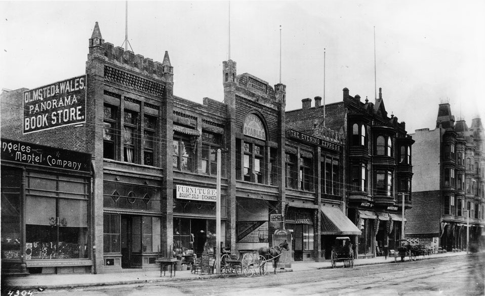 |
|
| (ca. 1890)^^* - View of Main Street south from 3rd Street. showing the Panorama Building. The Panorama Rotunda is conected to this building and stands to the rear, out of view. The Westminster Hotel, located on the northeast corner of 4th and Main streets, is seen at far right. |
Historical Notes Within a year of its construction, the brick storefront on Main Street through which panorama visitors entered, called ''Panorama Building,' was home to many business ventures, its owners quickly capitalizing on the prestige of the art work and its instantly recognizable address. Not only was it home to the painted battle scene, but also served as a warehouse for the Bancroft Piano Company; a rehearsal hall for the vocal section of the Philharmonic Society; the meeting space for the Young Man's Prohibition Club as well as the Harrison and Morton Club, a Republican party group; and Miss B.M. Tobin's millinery, directly adjacent to the offices of W.O. Merithew, architect. The Evening Express newspaper had its offices in the building, and the Olmstead and Wales Panorama Bookstore was also an early tenant.^*#* |
 |
|
| (1906)^*# - Sanborn map showing the location of the Panorama Building and the large rotunda, now called the Panorama Skating Rink. The Westminster Hotel is at lower-left (N/E corner of 4th and Main). |
Historical Notes As the city continued to grow and change, the painting was removed, and the rotunda began to take on an array of ventures. Throughout the 1890s and early 1900s, the rotunda housed Empire Stables, also seen in the previous image. In 1906 it was configured into a grand state-of-the-art roller skating rink. Unfortunately, it didn't last long as a skating venue; in 1907, the owner of the property, a Mr. Adolph Ramish, demolished the building and made plans to construct the Adolphus Theatre on the site, later to be called the Hippodrome.^*#* |
* * * * * |
Pacific Railway Powerhouse
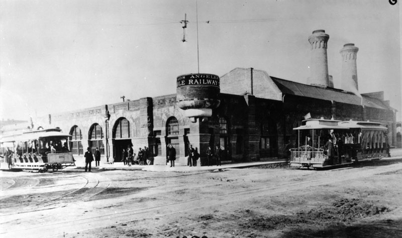 |
|
| (ca. 1888)* - Two separate cable cars arrive at the same location (7th and Grand) from different directions. The southwest corner building is the main power station for the Pacific Railway Company (formerly Los Angeles Railway). |
Historical Notes In September 1888, the Los Angeles Cable Railway Company sold their controlling interest to C. B. Holmes, and associates, of Chicago, Ill. They organized a new company, known as the Pacific Railway Company, capitalized at $5,000,000.00 and finished the construction of the cable lines, which when completed covered many of the LA streets with double tracks.^ |
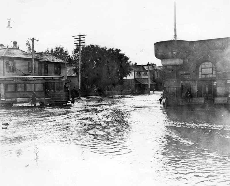 |
|
| (1890s)* - View of a flooded intersection at 7th Street and Grand Avenue. On the right, two men stay on high ground trying to avoid the rising water. To the left, a cable car appears to be stalled in the middle of the intersection. |
Historical Notes The principal power station for the Pacific Railway Company was located on the southwest corner of Seventh Street and Grand Avenue. Between 1904-1910, this building was used as a Post Office. Later, J. W. Robinson’s Dry Goods would build their first store at this corner.^ |
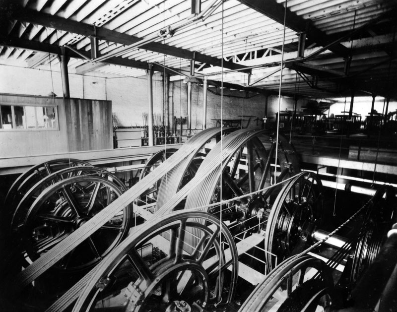 |
|
| (1890s)* - Interior view of the Pacific Railway Company power house, located at 7th and Grand, where huge wheels controlled the lines pulling the cable cars. |
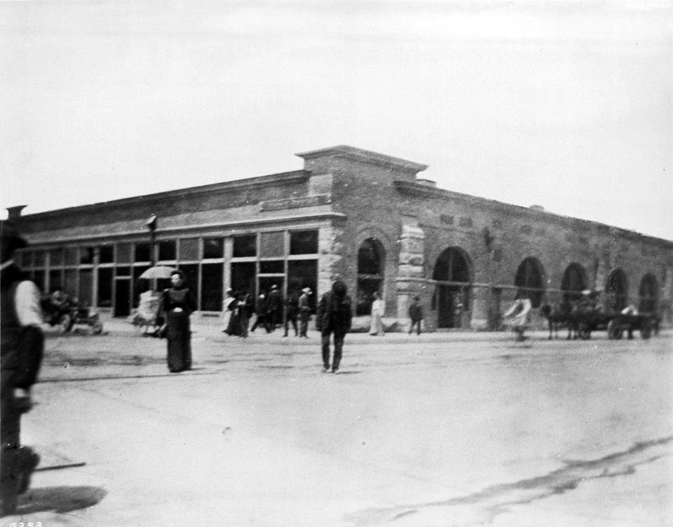 |
|
| (1906)^^* - Several people are seen crossing the street at the interscetion of 7th Street and Grand Avenue. The old Pacific Railway power house as been converted into a Post Office. The Romanesque architecture of the one-story building sports six visible arched windows to the right wall, while showing fourteen rectangular one-over-one sash windows to the left. |
Historical Notes The Post Office was moved here to Seventh and Grand in November 1904 and later moved away again in the September of 1910 to the corner of Main Street and Winston Street. The site, which was once the former cable power house, later became site of the J.W. Robinson Co. Department Store.^^* |
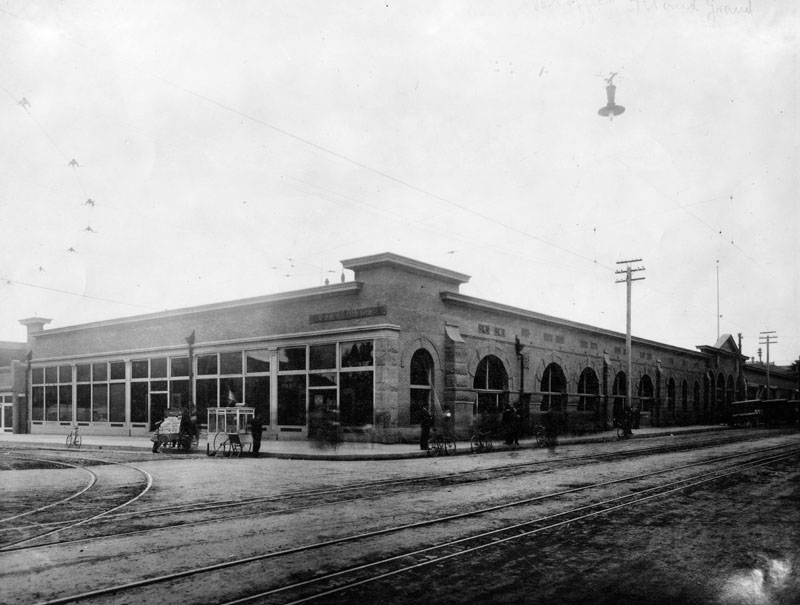 |
|
| (1907)* - View of the unpaved intersection of 7th Street and Grand Avenue, where a post office building sits on the southwest corner. This site later became the location of the large J.W. Robinson's store. |
* * * * * |
LA's First Electric Light Power Plant
 |
|
| (1888)* - View of Banning Street electric plant located on the corner of Alameda and Banning Streets. Photograph marked 1888 shows a brick building with men and a horse and buggy in front of it. |
Historical Notes The first electric light plant in Los Angeles was built in 1882 by C. L. Howland on the corner of Alameda and Banning Streets. One year later, Howland formed the Los Angeles Electric Company.* Click HERE to read the story behind LA's first electric power plant in Early Power Generation. |
* * * * * |
Mission Hotel (aka Porter Hotel)
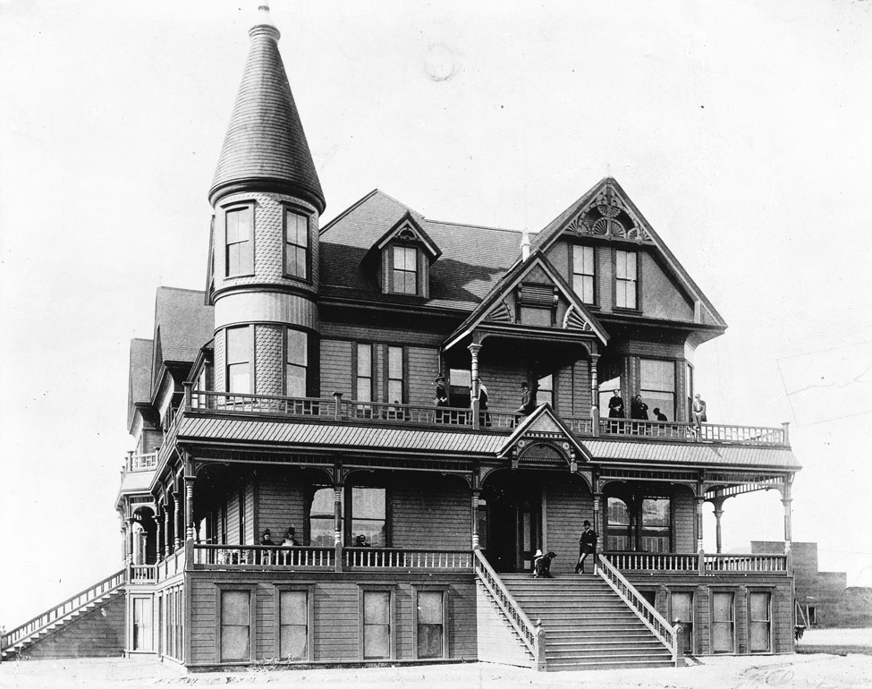 |
|
| (ca. 1888)* - The Mission Hotel located in the City of San Fernando. The three and a half-story, Victorian-style hotel is shown with people posing on its porch and balcony. On the second floor a man can be seen leaning against one of the beams which support the overhang near the hotel's entrance. A dog is visible near him at the top of the front steps that lead to the second floor and the subsequent entrance. On the second floor to the left, a two-story tower extends from the hotel, decorated in gingerbread clapboard. |
Historical Notes In the late 1800s the City of San Fernando, as well as the entire San Fernando Valley, saw a significant land boom A major hotel was built near the modern intersections of Laurel Canyon Boulevard and South Brand Street. Called the Mission Hotel, the building was built by the Porter Land and Water Company during 1887. |
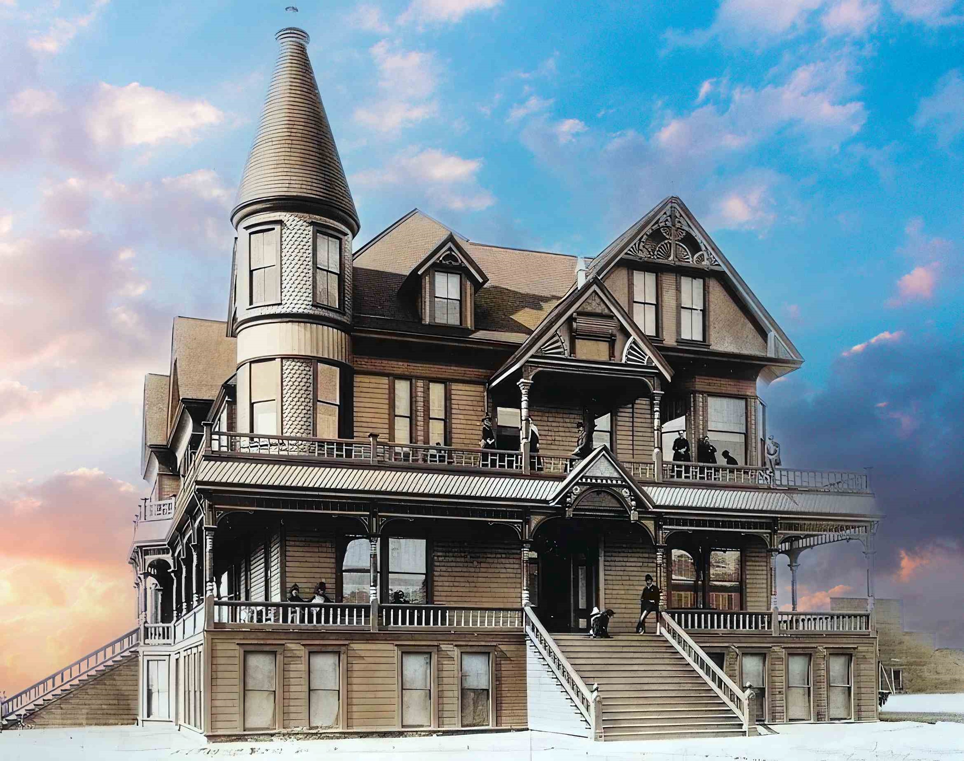 |
|
| (ca. 1888)* - The Mission Hotel located in the City of San Fernando. The three and a half-story, Victorian-style hotel is shown with people posing on its porch and balcony. On the second floor a man can be seen leaning against one of the beams which support the overhang near the hotel's entrance. A dog is visible near him at the top of the front steps that lead to the second floor and the subsequent entrance. On the second floor to the left, a two-story tower extends from the hotel, decorated in gingerbread clapboard. Photo enhancement and colorization by Richard Holoff. |
Historical Notes The Victorian-style building served as a hotel for about a year, and later, as a summer residence for the Porter family. |
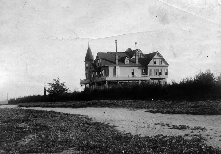 |
|
| (ca. 1890)* - Exterior view of the Porter Hotel (also called the Mission Hotel). Building was built in 1887, on a knoll about a mile from the center of San Fernando. It served as a hotel for about a year, and later, as a summer residence for the Porter family. |
* * * * * |
Hotel Cecil
 |
|
| (1888)^*^^ – View of the Hotel Cecil in Lankershim (North Hollywood). It was one of the first hotels in the San Fernando Valley. Pictured in the center is the owner, Mrs. Cecil Wilcox, with a dog by her side. A dozen men surround her, all posing for the photographer. |
Historical Notes Cecil Wilcox was the husband and his wife's given name was Clara. They appear in the censuses. He owned a furniture/book store and was apparently the publisher of a San Fernando Valley newspaper "The Lankershim Laconic." While it is not mentioned in the censuses, a newspaper article in the early 1950's promoting a "pioneer picnic" in Toluca/Lankershim, lists her as a widow who was the owner of the hotel. The photo date more than likely should be 1898 since Cecil was born in 1876. Clara (Hoegerman) and Cecil were married in 1897 in Los Angeles County. Cecil had died in 1933. Clara died in 1958. Ancestry.com has a picture of Clara and her sister Rose.^*# |
Click HERE to see more in Early Views of the San Fernando Valley |
* * * * * |
Please Support Our CauseWater and Power Associates, Inc. is a non-profit, public service organization dedicated to preserving historical records and photos. Your generosity allows us to continue to disseminate knowledge of the rich and diverse multicultural history of the greater Los Angeles area; to serve as a resource of historical information; and to assist in the preservation of the city's historic records.
|
For more Historical Los Angeles Views click one of the following:
For Other Historical Views click one of the following:
See Our Newest Sections:
To see how Water and Electricity shaped the history of Los Angeles click one of the following:
Water:
Power:
References and Credits
**DWP - LA Public Library Image Archive
* LA Public Library Image Archive
*# Mojave Desert.net: Remi Nadeau
#* Ancestory.com - Margarita Bandini Winston
#+Maviealosangeles.com Avila Adobe
+^Old Los Angeles and Environs blogspot
^# KCET - The Lost Hills of Downtown Los Angeles; A Vision for the Next Los Angeles: Transportation Equity and Just Growth
#^^theeastsiderla.com: Boyle Hotel
#*^LA Conservancy: Boyle Hotel; Vickrey-Brunswig Building
**^LA Fire Department Historical Archive
^^#The Museum of the San Fernando Valley
*^#CSULB - A Visit to Old LA: Hamburger Dept. Store; Figueroa Street
**#Tumblr.com - LA History: LA Times
*##Historic Los Angeles Theatres: Grand Opera House
^##California State Library Image Archive
^#*The Department Store Museum: J. W. Robinson's
#^*Early Downtown LA - Hollenbeck Hotel
***Los Angeles Historic - Cultural Monuments Listing
*^*California Historical Landmarks Listing (Los Angeles)
*^^*Los Angeles Past: City Hall (ca. 1895)
***^Historical Buildings - boyleheightsbeat.com
**^^Boyle Heights History Blog: Occidental College
**#^LAPL-El Pueblo de Los Angeles Historical Monument Photo Archive
^*^^San Fernando Valley Historical Society/Facebook.com: Burbank Villa Hotel; Hotel Cecil
^^^^US Department of the Interior: Vickrey-Brunswig Building
^*#*Panoramonview.org: Paorama of the Siege of Paris
^*##blogdowntown: Third Street Tunnel
*##*Pacific Coast Architecture Database (PCAD): Bryson-Bonebrake Block
*##^Pinterest.com: California Places of the Past
*#*#Flickr.com: Michael Ryerson
^#*^LA Times: Amestory Building; Newmark Fountain; Demolition of Old Times Bldg; Don Antonio Maria Lugo; Los Angeles Chinatown then and now
**## Mojave Desert.net: Remi Nadeau
#*^^Flickr.com: Views of Los Angeles
#^**Google Maps
#^#*Cinema Treasures: Childs' Opera House and Grand Theatre
#^#^St. Vincent's Medical Center: History
^*#Noirish Los Angeles - forum.skyscraperpage.com; Arcade Palm Tree; Angels Flight; Hotel Cecil; Wilson Block; LA City Hall; LA Times Building Bombing; Times Bldg Lit Up; North Los Angeles Street
^ On Bunker Hill: Crocker Mansion; Hershey Residence; Larronde Block and Residence; Brunson Mansion
^* Wikipedia: Abel Stearns; Pío Pico; Workman-Temple Family; Jonathan Temple; Los Angeles Herald-Examiner; Charles Maclay; Los Angeles High School; Cathedral of Saint Vibiana; John Edward Hollenbeck; Foy House; Isaias W. Hellman; Isaac Newton Van Nuys; Wells Fargo; Los Angeles Plaza Historic District; Harrison Gray Otis; Harris Newmark; Hazard's Paviolion; Fort Moore; Compton; Boyle Heights; Arcade Station; Avila Adobe; Los Angeles City Hall; Burbank; Angelino Heights; Boyle Hotel - Cummings Block; YMCA; Loyola Marymount University; Wikimapia: Vickrey-Brunswig Building
< Back