Early Los Angeles Programmatic-Style Buildings
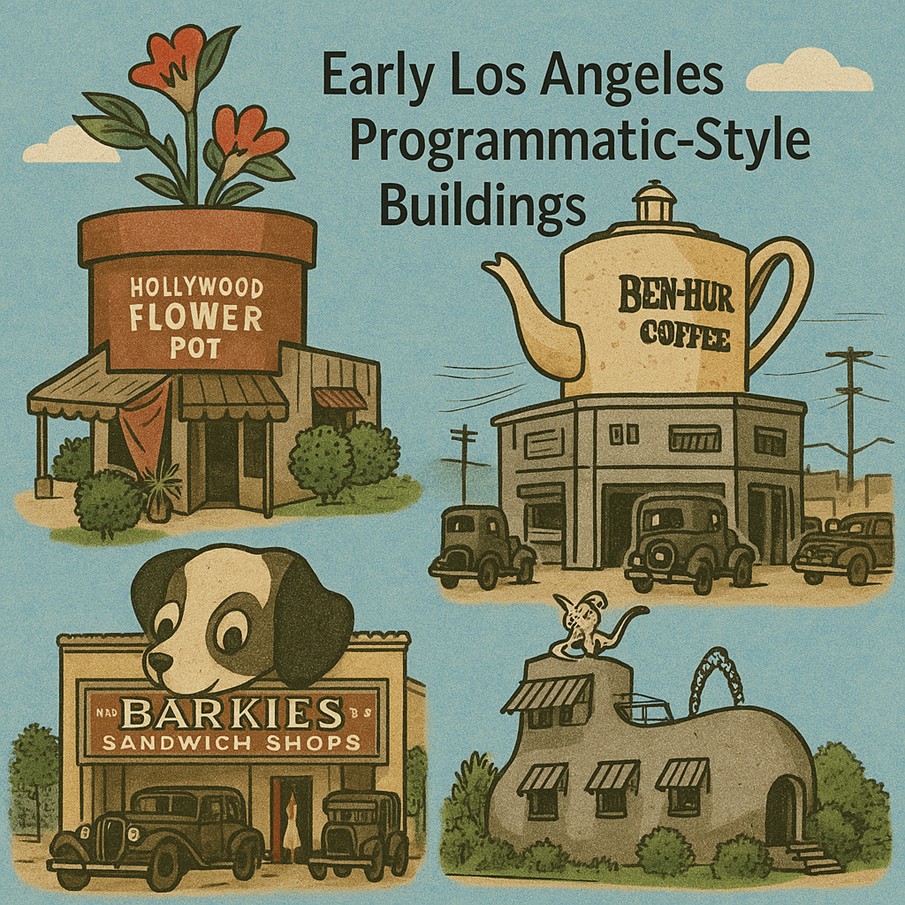 |
|
Background Los Angeles is known around the world for its programmatic or mimetic type architecture. The style rose to prominence after the wild success of the Brown Derby restaurant on Wilshire Boulevard in 1926. This giant object spawned at least 75 other roadside structures in the region shaped like animals, food or vehicles. These specimens were portrayed in popular media as lining LA streets and, along with the booming artist community, health food fads and creative expression of religion, added to Southland’s reputation as a bastion of eccentricity in the early part of the 20th century. The golden age of programmatic architecture was the interwar years (1918-1941), giving us several of the most bazaar-looking buildings, some of which still stand today. Programmatic architecture momentarily dotted the Greater Los Angeles landscape as it catered to the area’s expanding car culture and commuters by utilizing a commercial building’s architecture to advertise what products consumers could expect to find inside. The programmatic style of architecture was highly influenced by the exponential rise of the automobile, a trend that grew through the post-war era. |
|
* * * * * |
Hollywood Flower Pot
 |
|
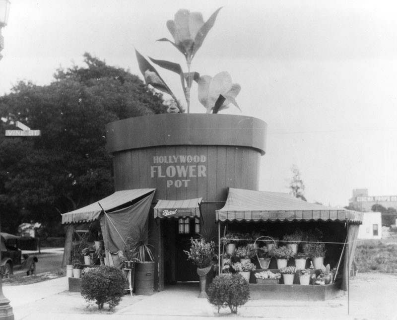
| (1920s)* - The Hollywood Flower Pot florist in the shape of a flower pot with a plant growing in it, located 1124 N. Vine Street (S/E corner of Vine St and Banner Ave). |
Historical Notes In the 1920s, as the automobile was becoming the default way to get around Los Angeles, buildings and structures in the area became more unique, often resembling the merchandise or services they hawked. These “hey-you-can’t miss-me!” buildings (referred to as Novelty or Programmatic architecture) were made to pull automobile drivers right off the road. |
* * * * * |
Coffee Cup Café
 |
|
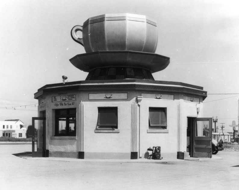
| (1920s)* - View of the Coffee Cup Café located at 8901 Pico Boulevard. A giant coffee cup and saucer sit on top of the cafe structure. |
* * * * * |
Wilshire Coffee Pot Café
 |
|
| (ca. 1928)* - View showing an automobile parked in front of the Wilshire Coffee Pot Restaurant, located at 8601 Wilshire Boulevard on the northwest corner of Stanley Drive and Wilshire Blvd., two blocks west of La Cienega Boulevard. A large coffee pot crowns the roof, advertising Ben-Hur Coffee to passing motorists. |
Historical Notes The Wilshire Coffee Pot was a classic example of Programmatic Architecture, a whimsical style popular in Los Angeles during the 1920s and 1930s in which buildings were designed to look like the products they sold. Its enormous rooftop coffee pot served as both structure and sign, catching the eye of motorists cruising along Wilshire Boulevard—then the city’s premier “Auto Row.” The restaurant catered to the growing car culture of early Los Angeles, where roadside novelty buildings like this became local landmarks. Ben-Hur Delicious Drip Coffee—a brand inspired by the 1925 silent film Ben-Hur: A Tale of the Christ—was the featured brew. |
 |
|
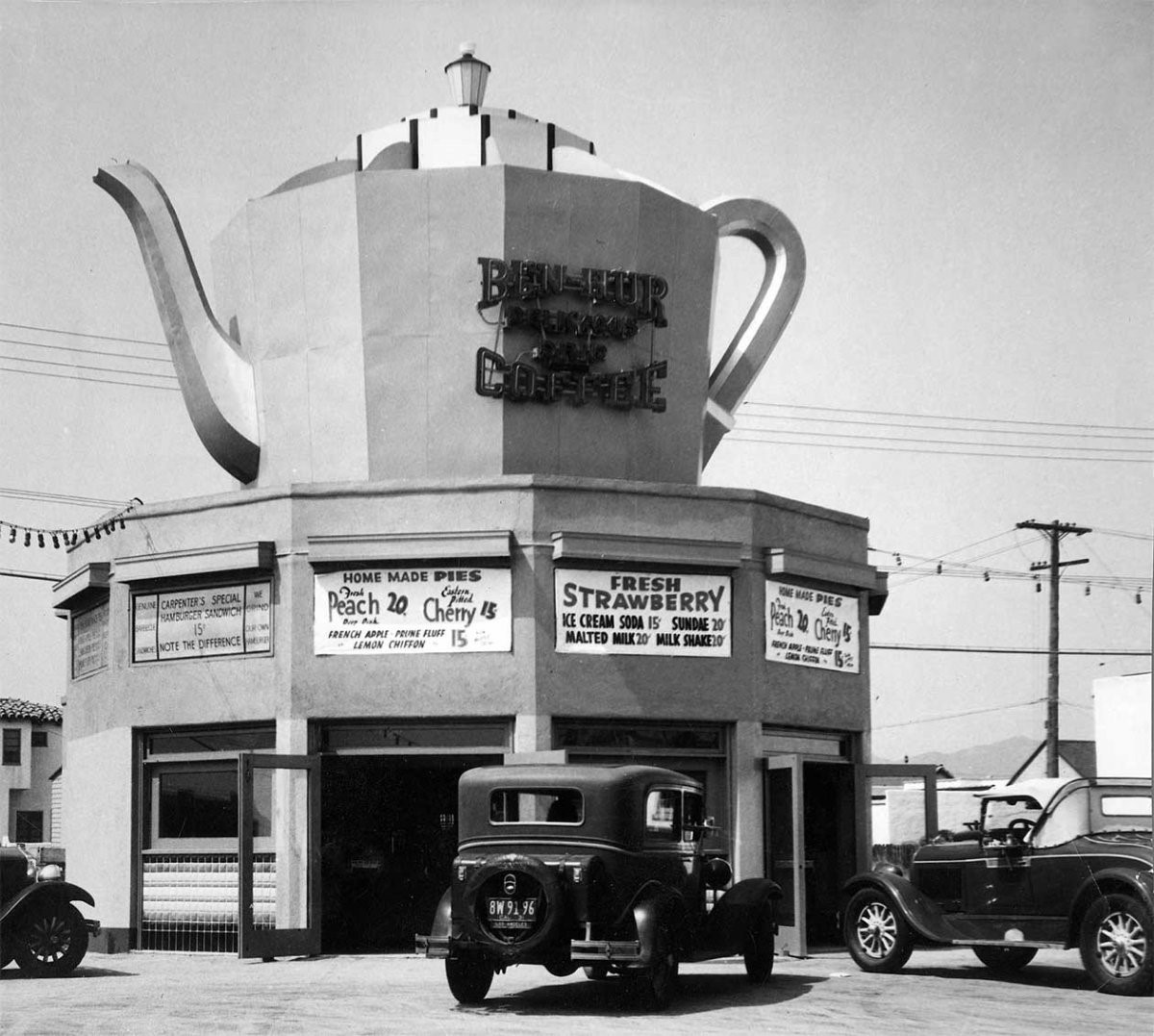
| (1930s)* - Wilshire Coffee Pot Restaurant and Café, located at 8601 Wilshire Boulevard in Beverly Hills. A sign advertises “Fresh Strawberry Ice Cream Soda – 15¢.” |
Historical Notes By the 1930s, the Wilshire Coffee Pot had evolved into a full café and soda fountain—reflecting the era’s fascination with roadside refreshments. The café’s playful design drew tourists, shoppers, and Beverly Hills locals alike, becoming a familiar stop for a quick bite or a cold drink. During this time, Wilshire Boulevard was rapidly developing into a major commercial thoroughfare linking downtown Los Angeles with the emerging “Westside.” Small businesses such as this thrived by appealing directly to the automobile traveler. |
 |
|
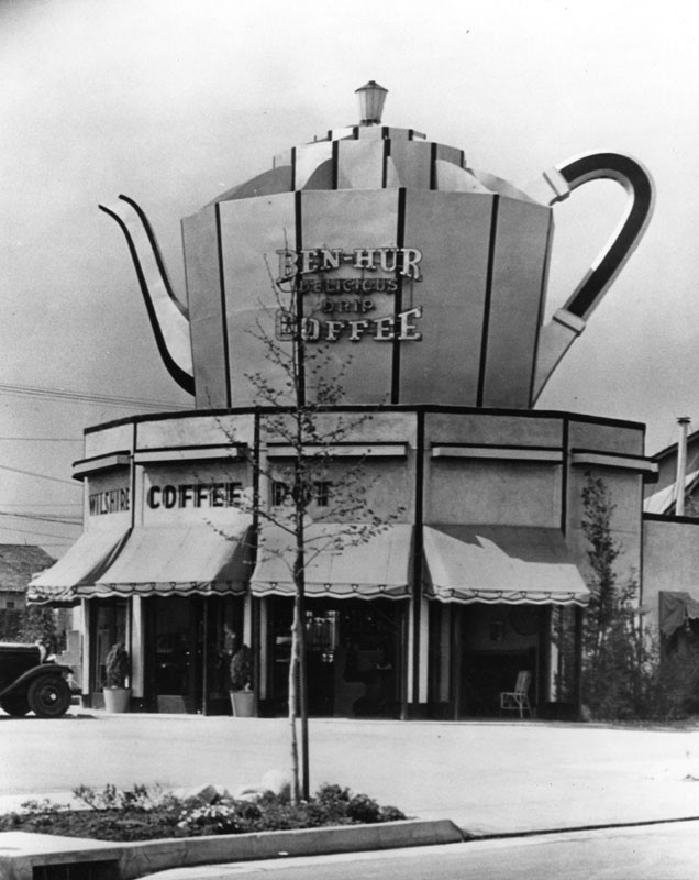
| (1930s)* - Close-up view of the Wilshire Coffee Pot Restaurant, 8601 Wilshire Boulevard, Beverly Hills. The giant coffee pot atop the roof advertises “Ben-Hur Delicious Drip Coffee.” |
Historical Notes This close-up highlights the bold visual branding of the Coffee Pot—one of Los Angeles’ most memorable examples of Programmatic or Novelty Architecture. In an age before neon dominance and billboards, such structures served as three-dimensional advertisements. The concept flourished in Southern California’s automobile culture, where attention-grabbing façades could be seen from blocks away. Though the Wilshire Coffee Pot no longer stands, its image endures as part of the city’s early roadside heritage—an era when architecture itself was designed to make motorists smile and stop for a cup of coffee. |
* * * * * |
Sphinx Realty
 |
|
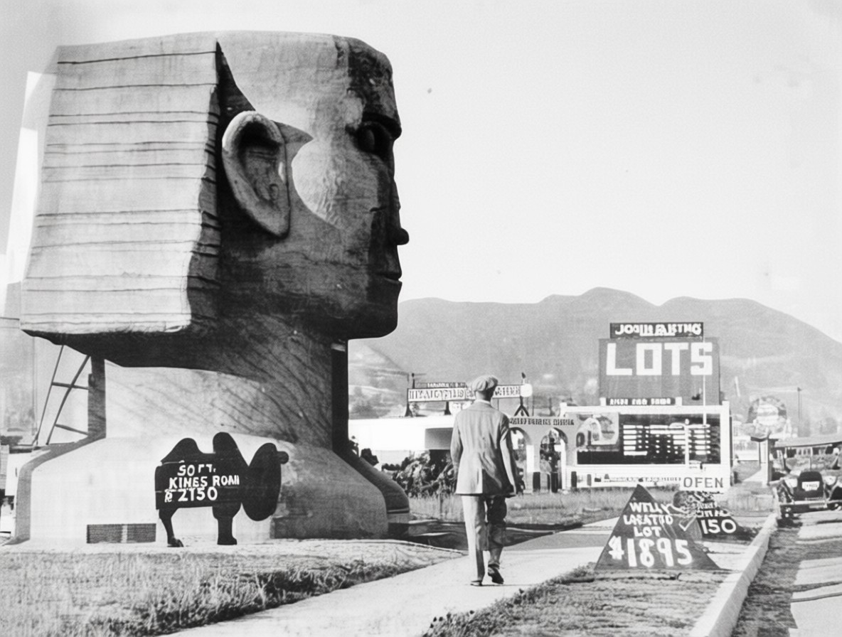
| (1920s)* – View looking north on Fairfax Ave showing a man walking in front of the Sphinx Realty Company. The building was located at 537 North Fairfax Avenue, across the street from Fairfax High School. Camel-shaped sign on the left reads: 50 ft. Kings Road - $2150. Triangular-shaped sign on right reads: Well Located Lot - $1895. |
Historical Notes In the early 1920s, Los Angeles was swept up in “Egyptomania” after the 1922 discovery of King Tutankhamun’s tomb. The Sphinx Realty Company took full advantage of the craze by constructing a small real estate office shaped like a giant sphinx at 537 North Fairfax Avenue. Built around 1923–1924, the building featured a sculpted sphinx head and upper body, with the hollow interior used as an office space. Its distinctive form made it one of the city’s most striking examples of programmatic, or mimetic, architecture—structures designed to advertise their purpose through visual spectacle rather than conventional design. The building stood across from the newly opened Fairfax High School (1924), at a time when the area was transforming from rural oil fields and open ranch land into a growing middle-class neighborhood. Camel-shaped and triangular signs around the sphinx promoted nearby lots for sale, with prices ranging from $1,895 to $7,650. The combination of ancient imagery and local marketing reflected Los Angeles’ playful approach to architecture—where even a real estate office could double as a roadside attraction. |
 |
|
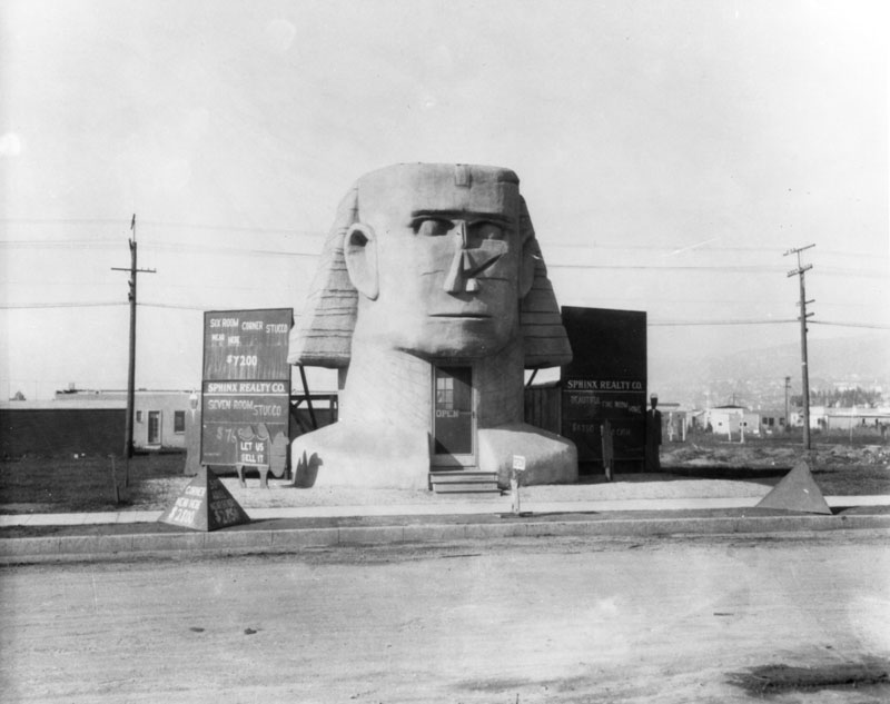
| (1920s)* - Exterior view of the Sphinx Realty Company, in the shape of a sphinx, located at 537 North Fairfax Avenue, surrounded by signs listing these properties for sale: Beautiful five bedroom home, $6,750; Six room corner stucco near here, $7,200; Seven room stucco, $7,650; Corner near here, $2,500. |
Historical Notes This view shows how Sphinx Realty combined novelty and commerce. The sphinx form caught the attention of passing motorists, while the nearby signs detailed the homes and lots for sale. The company’s marketing strategy relied on spectacle—using the allure of ancient Egypt to sell modern Los Angeles real estate. Such structures were popular throughout the 1920s, serving as architectural advertisements that stood out among the city’s expanding boulevards. |
 |
|
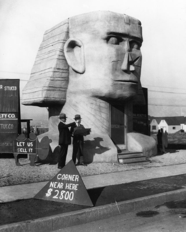
| (1920s)* - View showing two men standing in front of the Sphinx Realty Company sales building located on Fairfax Avenue. The office was located across the street from where Fairfax High School stands today. |
Historical Notes The two men in this photo provide a sense of the building’s scale, revealing how the sphinx’s head and shoulders framed a small, functional interior office. Visitors entered through an opening in the front of the structure, making the building both whimsical and usable. It was one of several small real estate offices that appeared along Fairfax Avenue during the area’s early development, each competing for attention with creative signage and architectural flair. |
 |
|
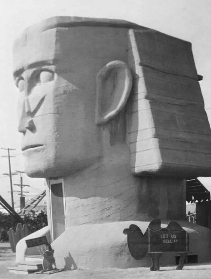
| (1920s)* - Sphinx Realty Company sales office, 537 N. Fairfax Ave - "LET US SELL IT". |
Historical Notes The phrase “LET US SELL IT” painted over the doorway emphasized that, despite its fanciful appearance, Sphinx Realty was a serious business operation. Like other novelty buildings of its era—such as those shaped like coffee pots, dogs, or hats—it was designed to be memorable. The structure’s dramatic form drew in curious onlookers who might otherwise have passed by, blurring the line between architecture and advertisement. |
 |
|
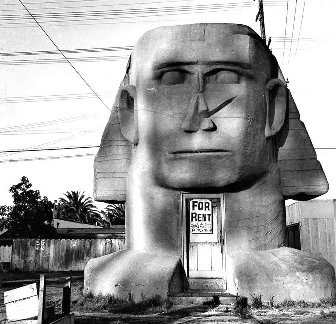
| (1920s)* - The Sphinx Realty building with a ‘For Rent’ sign on its front door. |
Historical Notes A “For Rent” sign eventually appeared on the sphinx’s front door, suggesting that the venture may not have been financially successful. By the late 1920s, Sphinx Realty disappeared from city directories, a victim of changing times and business realities. According to later recollections, the structure survived for decades after its business closed. By the 1950s, it was reportedly moved to an alley behind Fairfax Avenue, where neighborhood children nicknamed it “The Egyptian.” They explored its hollow interior before it finally vanished, leaving only a parking lot across from Fairfax High School’s football field. Though long gone, the Sphinx Realty building remains a fascinating relic of early Los Angeles imagination—a time when architecture served as advertisement, history mixed with humor, and the city’s optimism found expression in concrete, stucco, and spectacle. |
Then and Now
 |
|
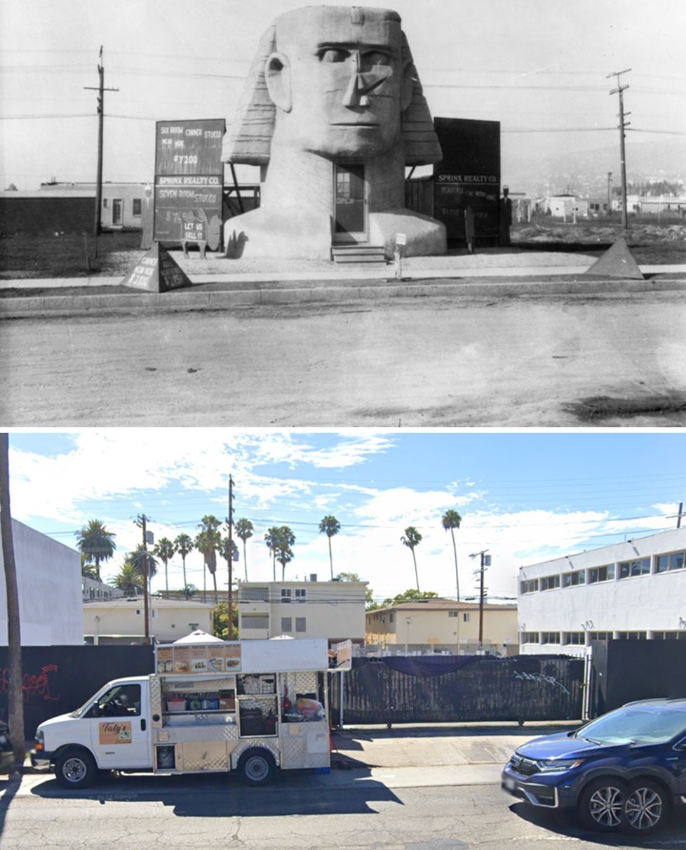
| (1920s vs 2022)* – Looking west at the whimsical Sphinx Realty Company sales office at 537 N. Fairfax Avenue, across from Fairfax High School. The Sphinx-shaped building once promoted local real estate developments. The site today is a parking lot. Photo comparison by Jack Feldman. |
Historical Notes The comparison between the 1920s and 2022 views underscores just how much Fairfax Avenue has changed over the past century. In the 1920s, the Sphinx Realty Company stood as a bold symbol of Los Angeles’ “novelty architecture” era—when buildings themselves became advertisements for the dreams they were selling. Its playful Egyptian motif, inspired by the nationwide fascination following the discovery of King Tutankhamun’s tomb, captured the city’s boundless optimism and flair for the fantastic. Today, the site across from Fairfax High School is an ordinary parking lot, its history invisible to passersby. Yet this unassuming patch of asphalt once hosted one of Los Angeles’ most imaginative real estate offices—a reminder of a time when creativity, commerce, and spectacle converged to shape the city’s identity. The juxtaposition of past and present offers a poignant reflection on how Los Angeles continually reinvents itself, often erasing the very eccentricities that once defined its character. |
* * * * * |
Barkies Sandwich Shops
 |
|
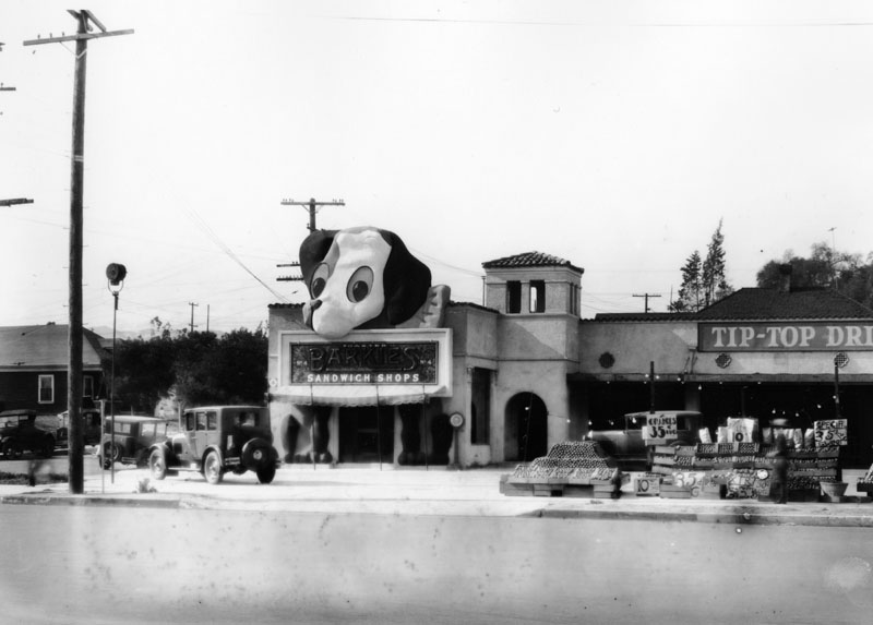
| (1930)* - View showing Barkies Sandwich Shop located on the northeast corner of Beverly Blvd and Westmoreland Ave. |
Historical Notes Barkies Sandwich Shops was a 1920s Los Angeles restaurant chain that reflected the city’s growing car culture and love of novelty architecture. Each small, stand-alone shop featured a giant dog mascot called the “Ponderous Pup,” with a large head, floppy ears, and a sign hanging from its mouth that read “Toasted Barkies Sandwich Shops.” The playful design turned each building into a landmark that was impossible to miss while driving by. Founded in the mid-1920s, Barkies specialized in toasted sandwiches—simple, inexpensive meals that appealed to motorists looking for a quick bite. By the late 1920s, the chain operated several locations throughout Los Angeles, often placed next to drive-in markets, tire stores, or small groceries. These clusters of businesses were an early version of the mini-mall concept that would later define Southern California’s retail landscape. The Barkies No. 4 location, at 3649 Beverly Boulevard (northeast corner of Beverly and Westmoreland), opened around 1927–1929. It stood along the Beverly Boulevard streetcar line, serving both drivers and commuters. The cheerful “Ponderous Pup” on the roof symbolized the city’s optimism during the booming late 1920s and its fascination with the automobile. |
 |
|
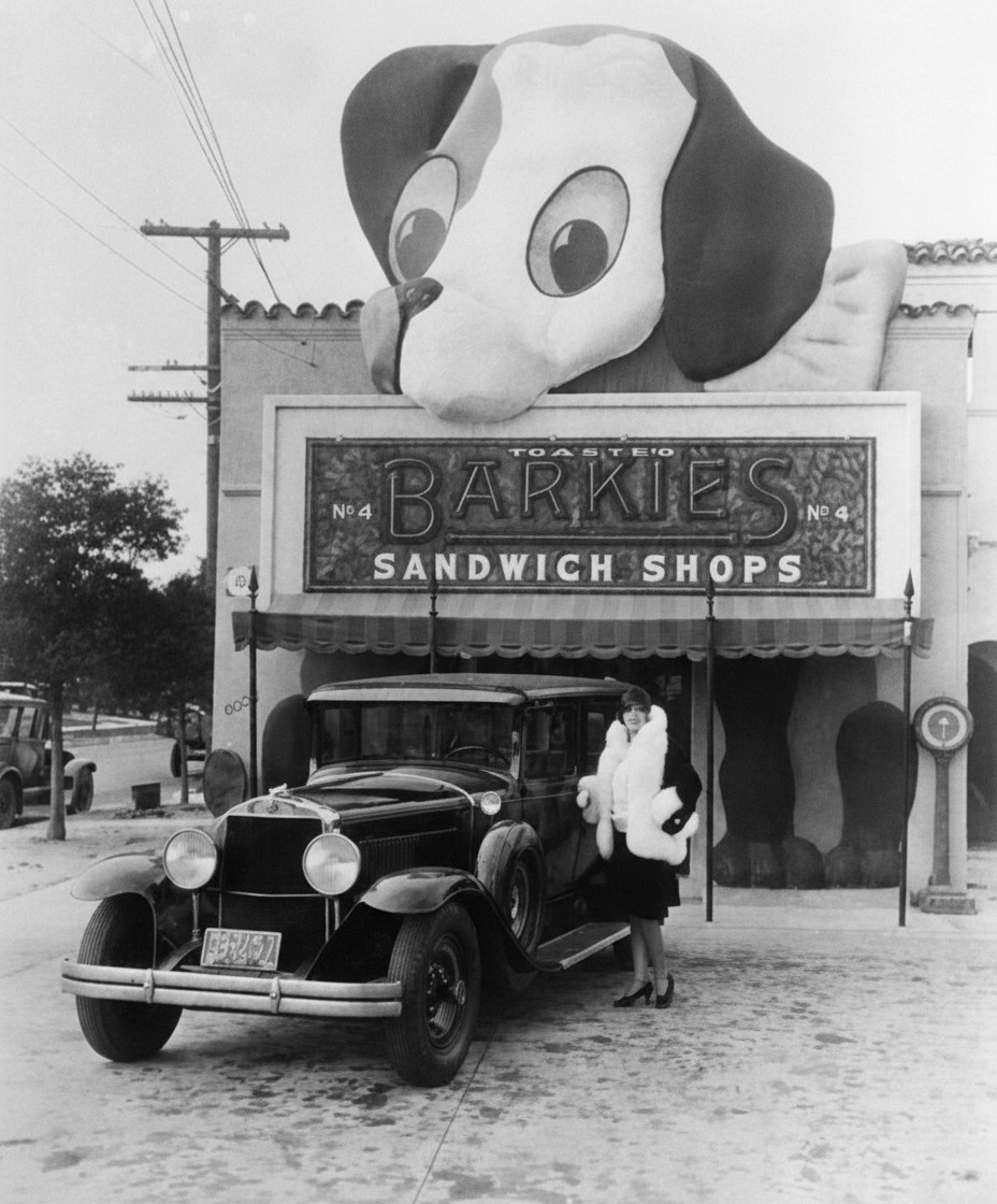
| (ca. 1930)* - A woman in a fur coat poses next to an early model car with Barkies Sandwich Shop No. 4 in the background. |
Historical Notes This photo captures the spirit of early 1930s Los Angeles—a mix of style, mobility, and playfulness. The woman’s automobile and elegant coat reflect the glamour of the motor age, while the oversized dog-topped Barkies building represents the city’s new fascination with roadside attractions. Barkies served toasted sandwiches that sold for a nickel or dime, offering a quick, affordable meal at a time when many people were struggling during the Great Depression. The whimsical design and photogenic appeal made Barkies a favorite stop for locals and travelers alike. |
 |
|
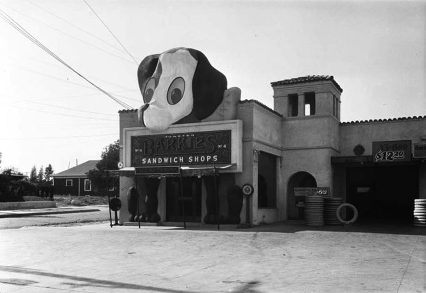
| (1930s)* - Barkies Sandwich Shop (No. 4), 3649 Beverly Blvd, with what looks like a tire store or auto shop as its neighbor. |
Historical Notes This view shows how Barkies often shared space with automobile-related businesses. The neighboring tire or service shop was typical for the period, when new commercial strips along major boulevards combined food, fuel, and car services in one location. This mix of convenience and accessibility was a forerunner to the modern shopping center. The Barkies building’s simple stucco exterior and bold signage reflected the functional yet lively character of early roadside Los Angeles. |
 |
|
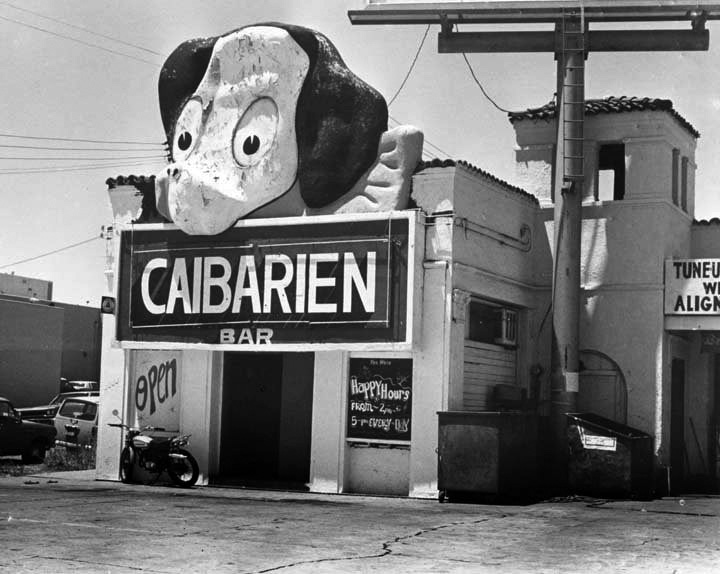
| (1974)* – View showing the Barkies Sandwich Shop No. 4 building seen here as the Caibarien Bar, with “Happy Hours from 2–5 pm Every Day. |
Historical Notes By the 1970s, the former Barkies building had been converted into the Caibarien Bar, a Cuban-themed lounge that served the changing community along Beverly Boulevard. The transformation from a daytime sandwich shop to an evening bar mirrored the area’s evolution as new immigrant populations made the neighborhood their own. Although the dog-head and paws had long been removed, the building’s basic structure remained intact, showing how early roadside architecture was often adapted rather than demolished. |
Then and Now
 |
|
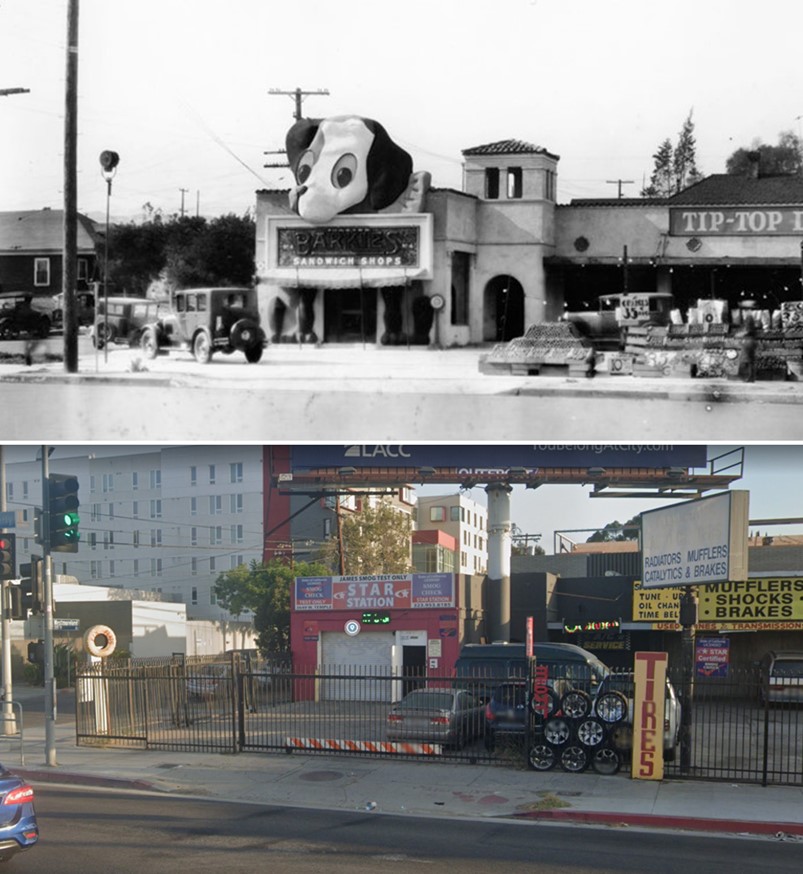
| (1930 vs 2022)* - Barkies Sandwich Shop, on the northeast corner of Beverly Blvd and Westmoreland Ave where today a Smog Check Station, Tire Store, and Auto Shop are located. Photo comparison by Jack Feldman. |
Historical Notes The northeast corner of Beverly Boulevard and Westmoreland Avenue has changed greatly since Barkies first opened its doors nearly a century ago. The original “Ponderous Pup” building gave way to practical auto service businesses such as a smog check station and tire shop, reflecting Los Angeles’ enduring connection to the automobile. Barkies itself disappeared during the 1930s, a victim of the Great Depression and changing times. Yet its memory survives in historic photos and postcards as a symbol of early Los Angeles ingenuity—a time when even a sandwich shop could become a local landmark thanks to imagination, charm, and the city’s love of the open road. |
* * * * * |
Mother Goose Pantry
.jpg) |
|
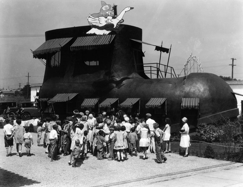
| (1927)* - Mother Goose Pantry, located on the north side of Colorado Blvd. between Berkeley and Greenwood Aves. View is to the west. |
Historical Notes This structure graced Colorado Blvd from ca. 1927 to at least the mid-1940s. |
 |
|
| (1920s)* - View showing Mother Goose Pantry, located at 1951 East Colorado Boulevard. This was a 'shoe-in' for best design in the 1920s. |
Historical Notes The restaurant served hearty meals from the whimsical shoe that attracted patrons driving along Route 66 from the east coast to Los Angeles. Diners would be seated on the ground floor and in a dining room upstairs. |
 |
|
| (1927)* - The Mother Goose Pantry in an ad in the 1927 cookbook by the Woman's Auxiliary of the Pasadena Fire Department. Source: Pasadena Central Library |
* * * * * |
The Cream Can
 |
|
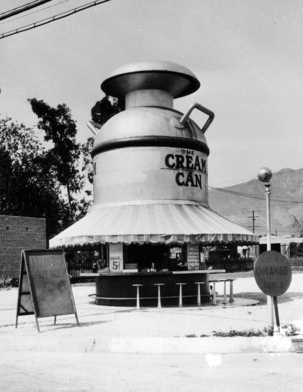
| (ca. 1920s)* – View showing the Cream Can stand located somewhere in Southern California. Signs read: ORANGE JUICE and JUMBO ROOT BEER |
 |
|
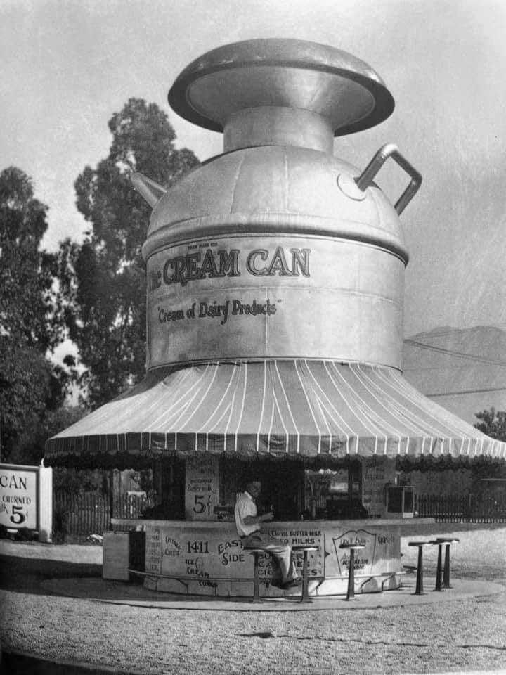
| (1928)* – A man seems to be enjoying a treat at the Cream Can in Los Angeles. |
* * * * * |
Freezer Ice Cream Parlor
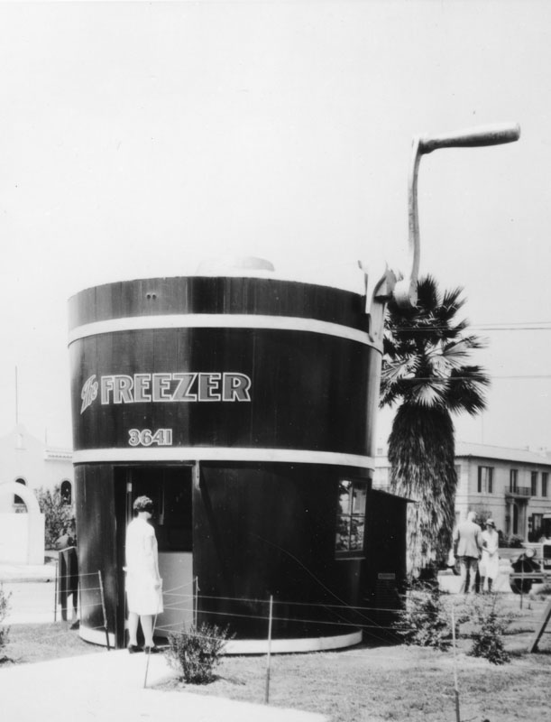 |
|
| (1920s)* - View showing The Freezer, an ice cream parlor in the shape of an ice cream maker complete with a giant crank, located at 3641 Pico Boulevard. |
Historical Notes The Freezer was a mini chain of ice cream outlets, and each store was built into the shape of an ice cream churn. They also had locations at 7435 Sunset, 1124 Vine, 3801 W Washington, 402 S Western, and one in Alhambra. |
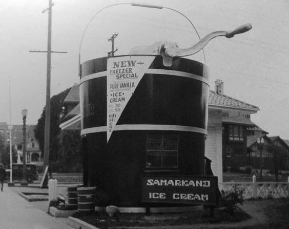 |
|
| (1920s)* - View showing The Freezer Ice Cream Parlor, selling Samarkand Ice Cream. Sign reads: ‘New Freezer Special – Pure Vanilla’. |
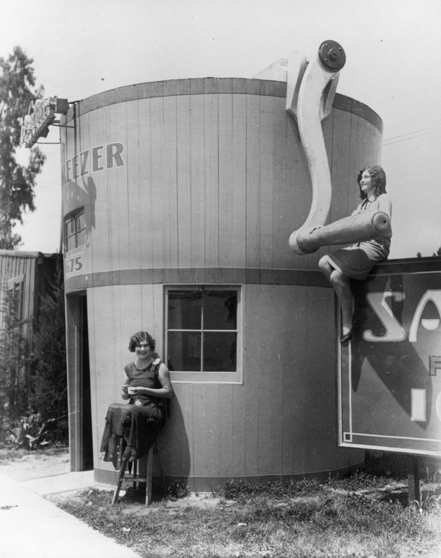 |
|
| (1920)* - Two women pose next to The Freezer Ice Cream Parlor. |
* * * * * |
Hoot Owl Café
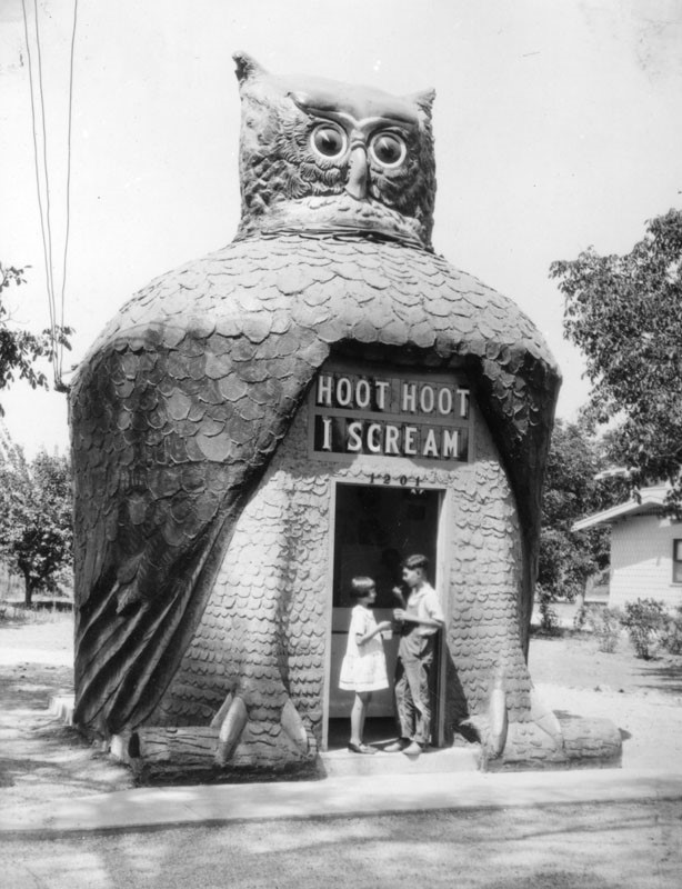 |
|
| (1920s)* - View showing a boy and girl enjoying Hoot, Hoot ice cream in front of Hoot Owl Café. |
Historical Notes I Scream Hoot Owl Café was in the shape of an owl. The head rotated; the eyes, made from Buick headlamps, blinked; the sign: Hoot Hoot, I Scream, used elements of a theater marquee. For over 50 years, Tillie Hattrup ran this refreshment spot designed and built by her husband, Roy in 1926-27. It was originally on Valley Boulevard, then moving to 8711 Long Beach Boulevard, before being demolished in 1979. |
* * * * * |
Igloo Ice Cream Parlor
 |
|
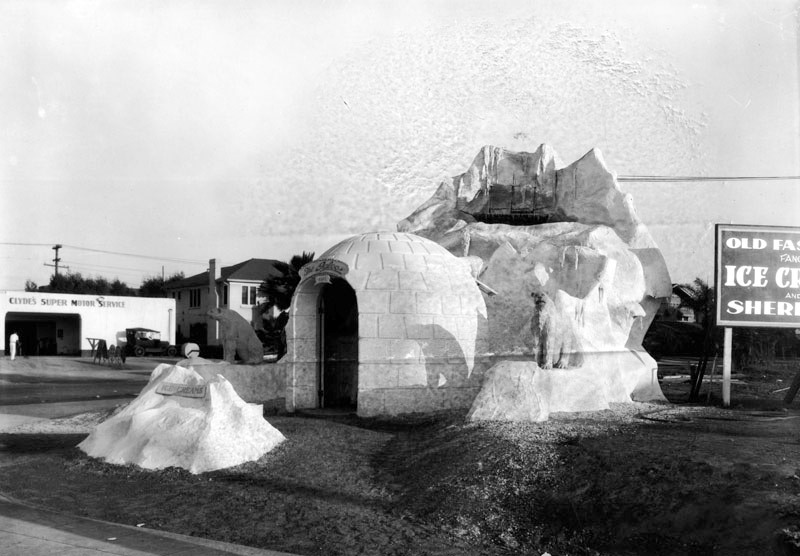
| (1927)* - View showing The Igloo, an igloo-shaped ice cream parlor located at 4302 W. Pico Blvd. A sign is partially shown, and reads: "Old fashioned fancy ice cream and sherbet". Clyde's Super Motor Service can be seen in the background. |
 |
|
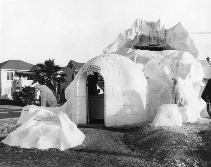
| (1927)* - Close-up view showing the entrance to The Igloo Ice Cream Parlor located on the south side of Pico Boulevard just west of S. Victoria Avenue. The igloo is attached to a huge "ice berg," on top of which sits a stranded ship. Two polar bears flank the entrance. |
 |
|
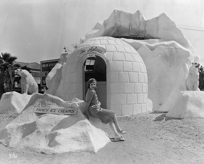
| (1920s)* – View showing a woman posing for the camera in front of The Igloo Ice Cream Parlor. Sign in front reads: ‘Fancy Ice Creams’. |
 |
|
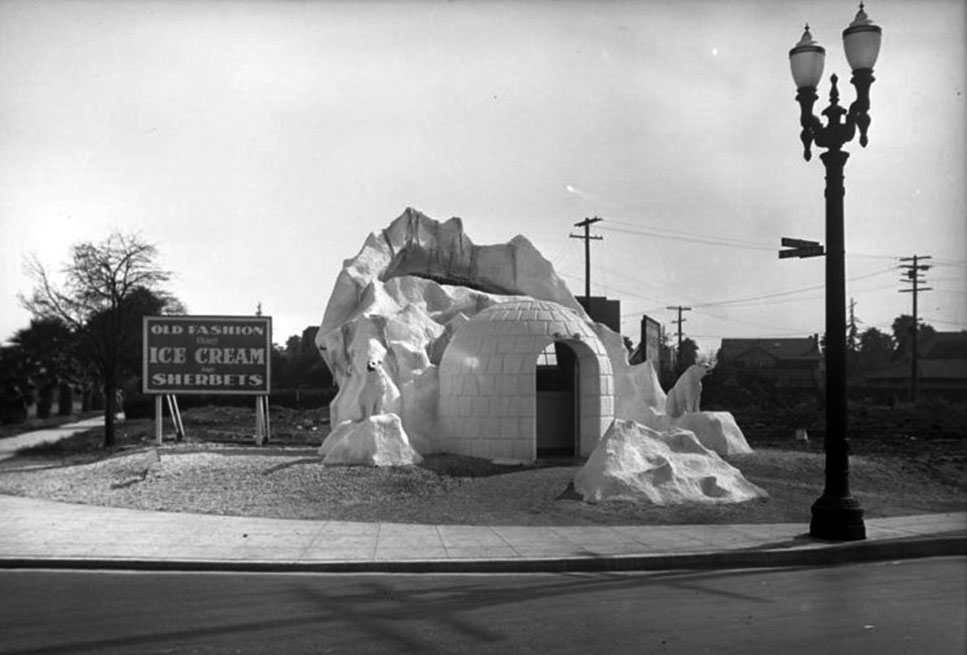
| (ca. 1930)* - The Igloo located on the SW corner of Pico Blvd and Victoria Ave, serving “Old Fashion Ice Cream and Sherbets”. |
* * * * * |
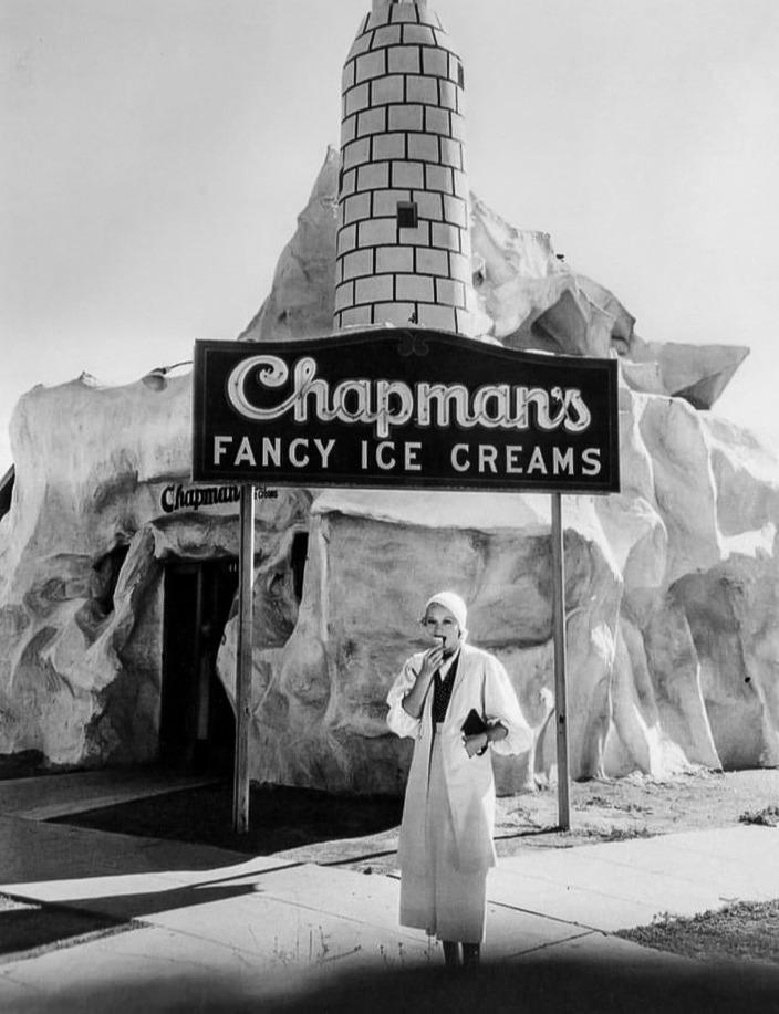
Chapman's Fancy Ice Cream
 |
|
| (1930s)* - Enjoying an ice cream cone in front of Chapman's Fancy Ice Cream located at 951 Westwood Blvd. |
* * * * * |
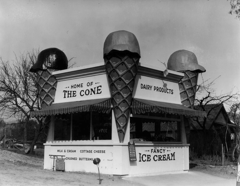
Home of The Cone
 |
|
| (ca. 1920s)* - Home of The Cone, an ice cream parlor with an oversized ice cream cone at each corner, located at 2626 Colorado Boulevard in Eagle Rock. A house can be seen behind the parlor, on the right side. |
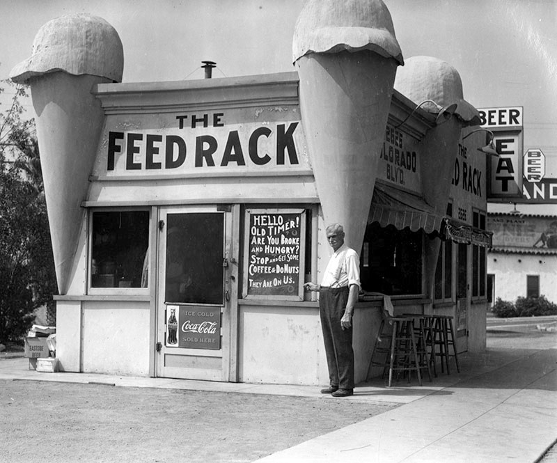
Historical Notes This small establishment offered dairy products such as milk & cream, cottage cheese, churned buttermilk, and fancy ice cream. The building eventually became the Feed Rack, a small restaurant, during the Depression. |
 |
|
| (ca. 1930)* - Originally built as an ice cream parlor, with an oversized ice cream cone at each corner, the building became the Feed Rack, a small restaurant, during the Depression. An older man (possibly the owner) points to a sign: "Hello, Oldtimer! Are you hungry? Stop and get some coffee & donuts. They are on us." |
* * * * * |
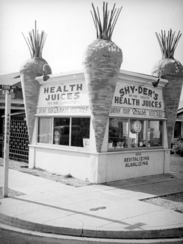
Shy-Der's Health Juices
 |
|
| (ca. 1938)* - This little juice stand located on the southwest corner of York Blvd and N Ave 49 has giant carrots on all four corners, incorporated into the architecture. |
Historical Notes Although Shy-der's Health Juices has been demolished, the house behind it still stands. Click HERE for contemporary view. |
* * * * * |
Betsy Anne Ice Cream & Candy Store
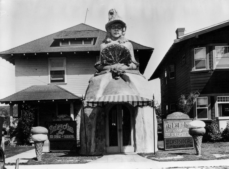 |
|
| (1930s)* - View showing the Betsy Ann Ice Cream and Candy Store. The entrance is in the shape of a woman with a hat, long curls in her hair, a large hoop skirt, and holding a fan. Two ice cream cones flank the entrance. Signs on either side of her read: "We manufacture our own ice cream and candies", below that, another sign reading, "Betsy Ann fancy ice cream & candies", and "Good Old Eastside. The perfect brew. We serve cold drinks of all kinds". |
Historical Notes Named for family friend and child star Betsy Ann Hisle, whose likeness was recreated in the structure, at one time there were multiple parlor locations. |
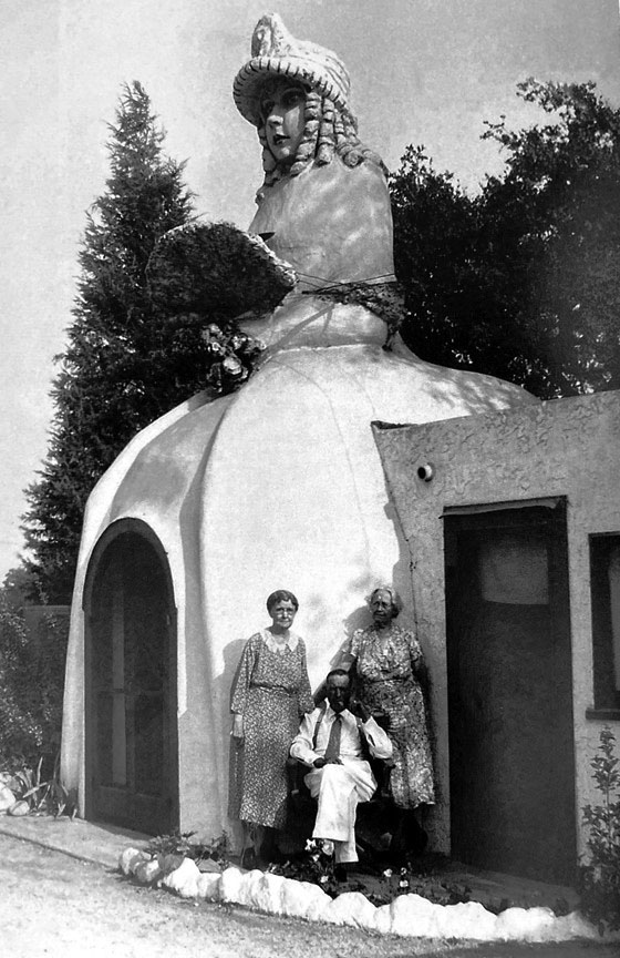 |
|
| (ca. 1930)* - View of originator Arthur Hartman and family in front of the original Betsy Ann Ice Cream Parlor, Foothill Boulevard in east Pasadena. |
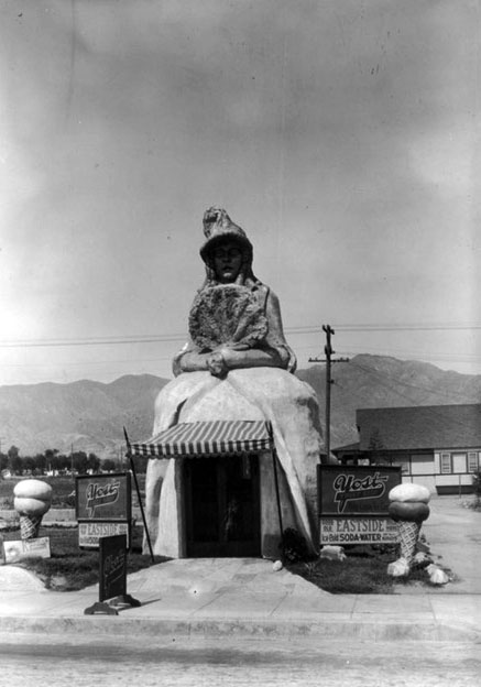 |
|
| (1930s)* – View showing another Betsy Ann Ice Cream Shop possibly located at 804 San Fernando Road in Burbank. Signs on either side of her read: “Candy – tobaccos. Yost Sweet Shop. Whipped Ice Cream.” "Good old Eastside. Sold here. Ice cold soda – water of all kinds.” |
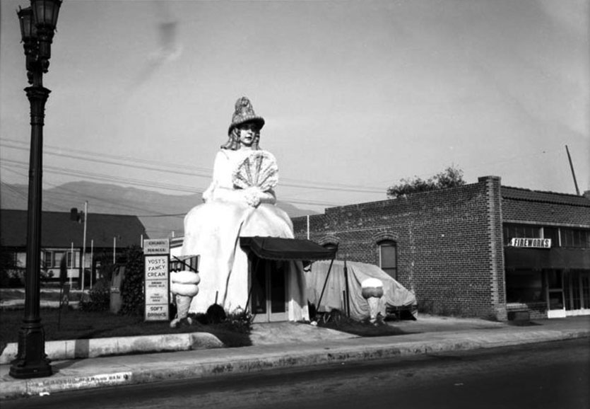 |
|
| (1930s)* - Betsy Ann Ice Cream at what appears to be the same location as previous image but several years later. W. C. Sawyer Collection |
* * * * * |
The Jumbo Lemon
 |
|
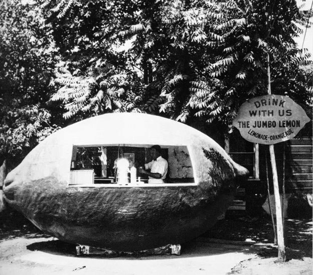
| (1920s)* – Programmatic-style Jumbo Lemonade stand located in Los Angeles. Sign reads: “Drink with us – The Jumbo Lemon – Lemonade – Orangeade.” |
* * * * * |
The 'Cornucopia' Big Cone
 |
|
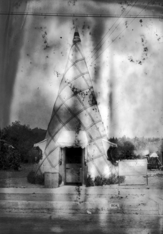
| (1928)* - The Cornucopia ice cream stand, located at 1934 San Fernando Blvd, was in the shape of a huge upside-down ice cream cone. It had two small windows on both sides and a doorway at the front, all with awnings. A sign on the right of the cone reads: "Bonded quality ice cream. Open 11 AM to 10 PM. Malted milk candies". The 'speckling' on the photo is from a bad nitrate negative. Photo dated: April 19, 1928. |
 |
|
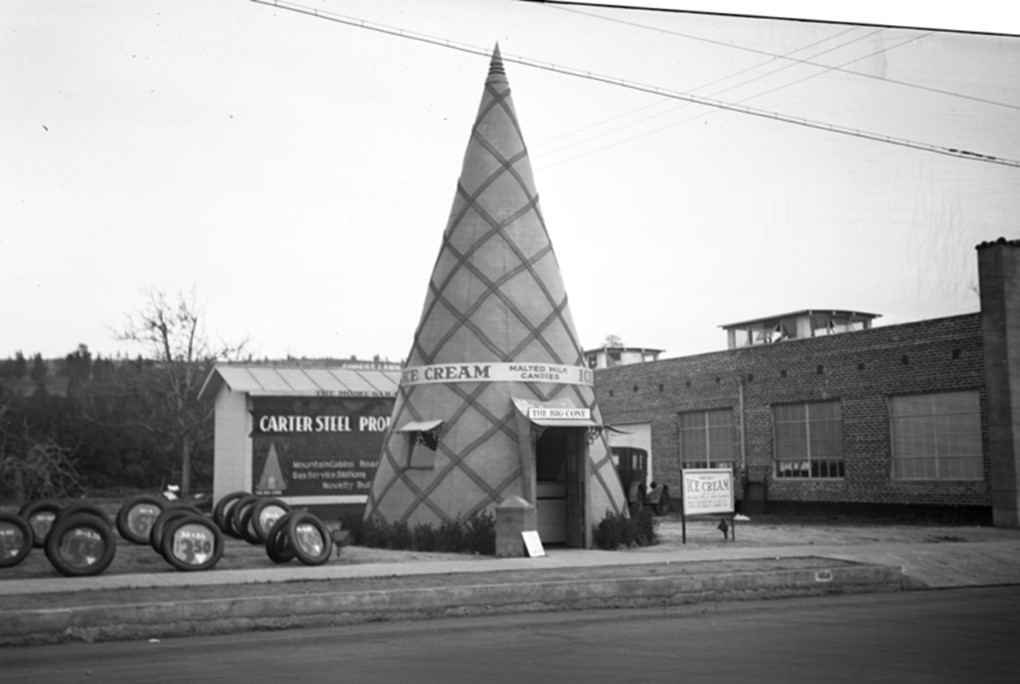
| (ca. 1930)* - The Cornucopia Ice Cream stand has a large sign above its entrance reading 'The Big Cone'. The upside down big cone is now surrounded by an industrial building and a lot full of tires for sale. |
* * * * * |
The Big Cone
 |
|
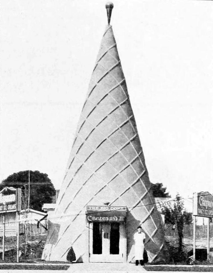
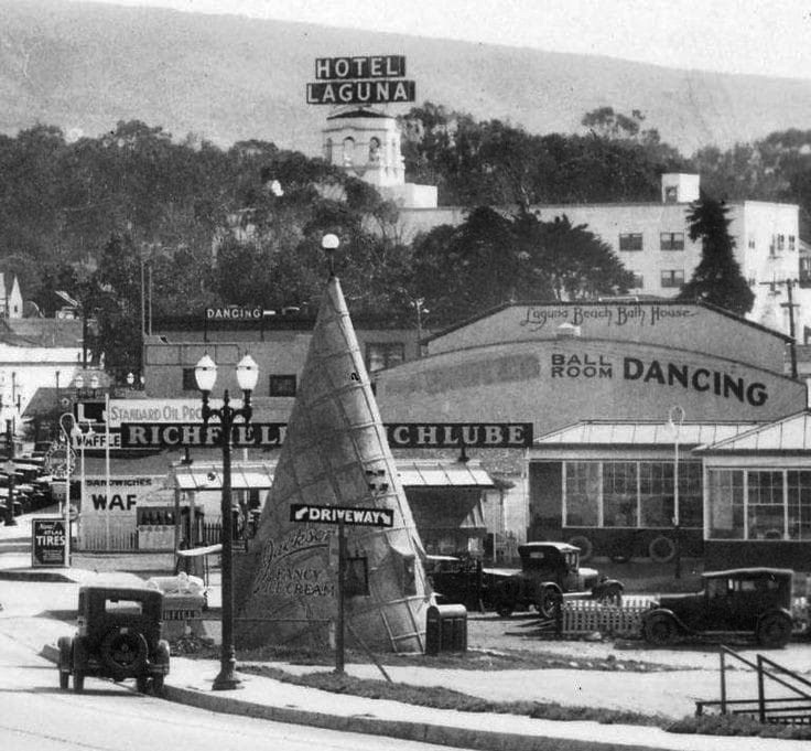
| (1930s)* – View showing a man standing in front of the The Big Cone, a Chapman’s Ice Cream parlor. |
Historical Notes The original Chapman ice cream 'Big Cone' shop was located at Chapman Avenue and North Main in Santa Ana, hence the name. It was part of a chain of Big Cone ice cream outlets established by Frank E. Jackson and George N. Nazel of Santa Ana. The Big Cone Operating Company (you can see the sign above the door) hoped to have one in every city in Orange County. There was one in Fullerton, Orange, Laguna Beach, and Balboa, and as far away as Nashville. The Local History Room of the Fullerton Public Library has a photograph of the Fullerton one, then called Helen’s Cones in the 1930s. There is a brief history of the company in the Santa Ana Register, March 11,1928. What makes the cones particularly cool is that the owner filed a patent for the building design. Des. 75, 511. |
 |
|
| (1930s)* – Jackson’s Fancy Ice Cream ‘Big Cone’ shop located in Laguna Beach, originally Chapmans Ice Cream. |
* * * * * |
Oil Can Restaurant
 |
|
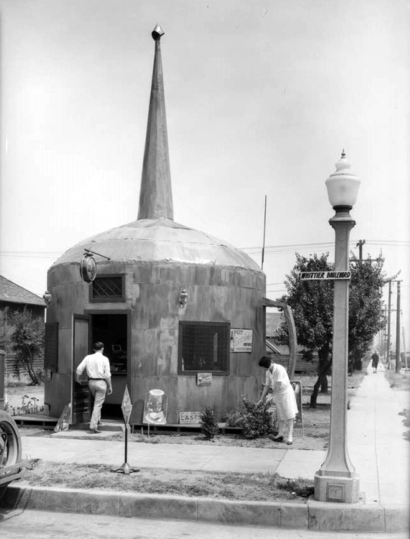
| (1928)* – View showing the Oil Can Restaurant located on Whittier Boulevard in Montebello. |
Historical Notes The tiny diner mimicked the shape of the cans once used to lubricate machinery, complete with a giant handle and a spout that towered above the building's domed roof. The Oil Can was built in the 1920s on Whittier Boulevard in honor of the underground oil that had been found prior in the Montebello region that the restaurant was located. The restaurant served food, ice cream, and beer brewed by Eastside Beer. Eastside Beer was eventually purchased by Pabst Brewing. |
 |
|
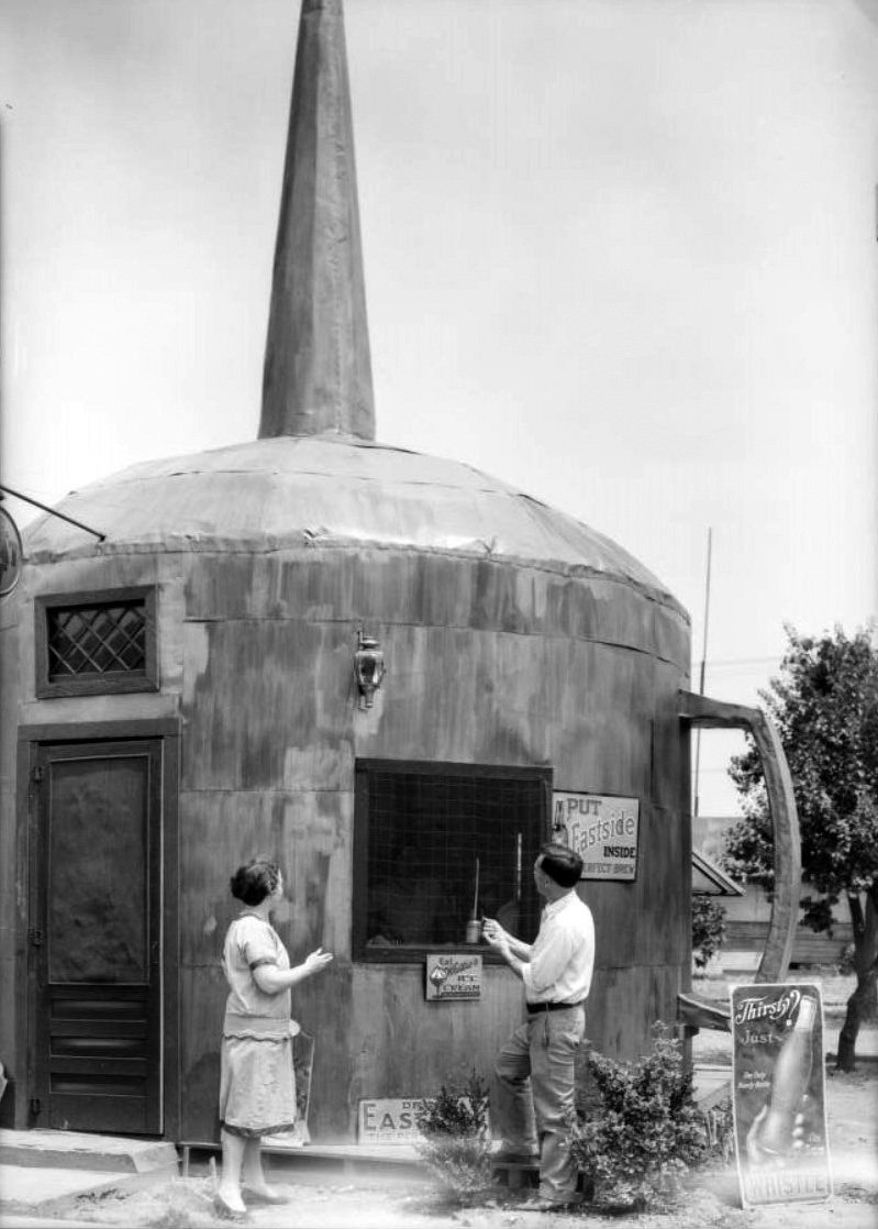
| (1928)** - Closer view of the Oil Can Restaurant with a man and woman (maybe the owners) standing in front of the window. Several signs appear on the building advertising: Ice Cream, Eastside Beer, and Soda. |
Historical Notes The discovery of an underground oil field in 1917 had brought fortune to the town and transformed its once graceful hills ("Montebello" is Italian for "beautiful mountain") into a forest of wooden derricks. |
* * * * * |
Venice Pier - Battleship Restaurant (?)
 |
|
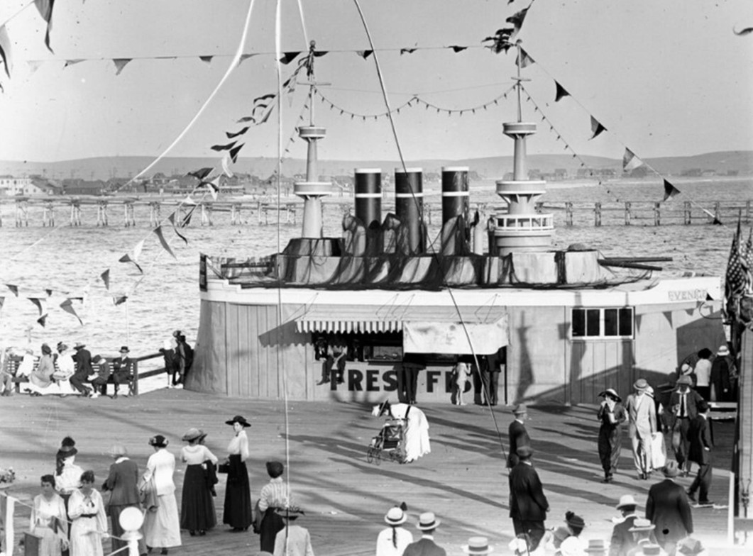
| (1910s)* – A food stand made to resemble a battleship sits at the edge of Venice Pier. Caption reads: ‘Some people are strolling, some are sitting and watching the ocean, some are getting food to eat from the restaurant right next to the pier.’ |
* * * * * |
Airplane Café
 |
|
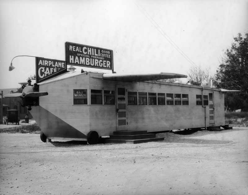
| (ca. 1924)* - View of the Airplane Café, a restaurant in the shape of a plane, complete with wings and a propeller. The structure has wheels, but rests on raised slabs of wood. The sign on roof reads: REAL CHILI - GOOD COFFEE - SPECIAL PREPARED HAMBURGER. |
.jpg) |
|
| (ca. 1924)* - Front end view of the Airplane Café (address unknown). The sign in the window reads: “Girl Wanted”. |
* * * * * |
The Dugout Restaurant
 |
|
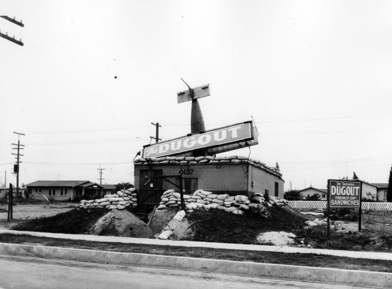
| (1929)* - "The Dugout" sandwich stand, which is surrounded by sandbags and has a plane crashed into its roof, located at 6157 E. Whittier Blvd. A sign outside reads: "The famous Dugout French dip sandwiches". |
 |
|
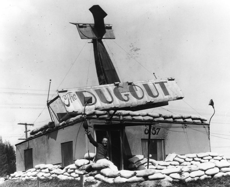
| (1920s)* - Close-up view of "The Dugout" showing a man in a soldier's uniform waving from behind sandbags in front of the restaurant. |
* * * * * |
Zep Diner
 |
|
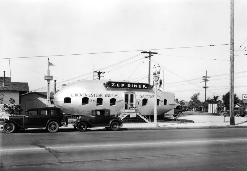
| (1931)* - View of Zep Diner, located at 515 W. Florence Ave, near Figueroa St. A sign hanging from the stairs advertises lunch for .40 cents. The Zep was open “all night” and was the “Home of the Hinden Burger”. The location is now a McDonald’s parking lot. |
Historical Notes The Zep Diner, located at 515 W. Florence Avenue in Los Angeles, was a distinctive example of novelty architecture from the early 20th century. Opened in the 1930s, the diner was designed to resemble a zeppelin, reflecting the era's fascination with airships, particularly the German-made Zeppelins, which were the largest aircraft ever built at the time. It was likely inspired by the visit of the Graf Zeppelin in 1929 during its around-the-world voyage. Click HERE to see more on the Graf Zeppelin's visit to Los Angeles. |
 |
|
| (1931)* - View of two women standing on the stairway leading to the entrance of Zen Diner. There is a Gilmore Service Station next door. |
Historical Notes The Zep Diner operated 24 hours a day and was known for its unique "Hinden Burger," named after the famous Hindenburg airship. This thematic connection to airships extended beyond the menu; the architectural design itself made the diner a notable roadside attraction of its time. |
.jpg) |
|
| (1931)* - Front view of Zep Diner, located at 515 W. Florence Ave, near Figueroa St., before it was painted and given signage. It is in the shape of a zeppelin, or more commonly referred to as a blimp. Back door is open, which leads to stairs and directly to the sidewalk. Photo dated: March 21, 1931. |
* * * * * |
The Tamale
 |
|
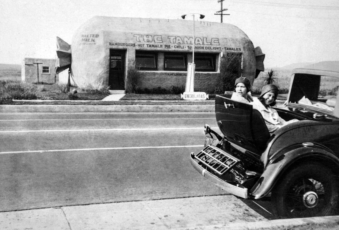
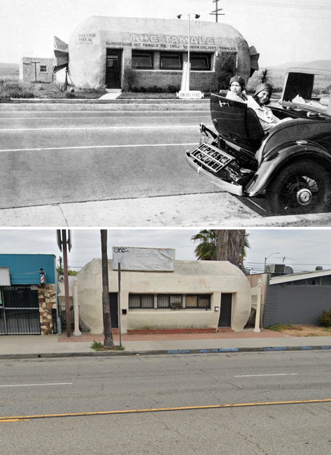
| (1928)* – Two young women pose for the camera while sitting in the rumble seat of an early model car parked across the street from The Tamale, located at 6421 Whittier Boulevard in East Los Angeles. |
Historical Notes The Tamale, a whimsical tamale-shaped building in East Los Angeles, was built around 1928 as a roadside eatery by Samuel C. Wilhite. It’s a prime example of programmatic architecture, where the building itself advertises what’s inside—in this case, tamales and other casual fare. Designed to resemble a giant wrapped tamale, the structure was one of several novelty buildings along Whittier Boulevard during L.A.’s car culture boom of the 1920s–30s. Though many of its contemporaries were demolished, The Tamale endured, quickly becoming a neighborhood landmark and beloved oddity. |
 |
|
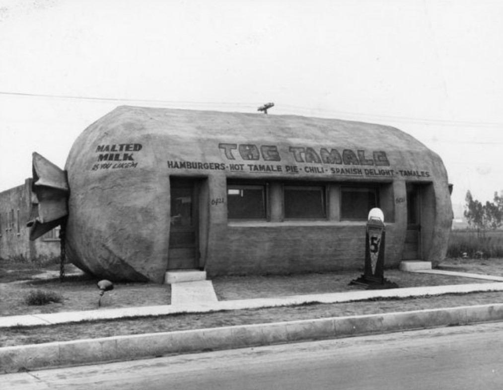
| (1928)* - Close-up view showing The Tamale, built in the style of programmatic architecture. Its stucco body mimicked a giant wrapped tamale, with painted signage and a freestanding 5¢ ice cream sign drawing attention to this eye-catching local landmark. |
Historical Notes For decades, The Tamale operated as a small restaurant offering tamales, chili, and other “Spanish” dishes to a largely Mexican-American clientele. |
 |
|
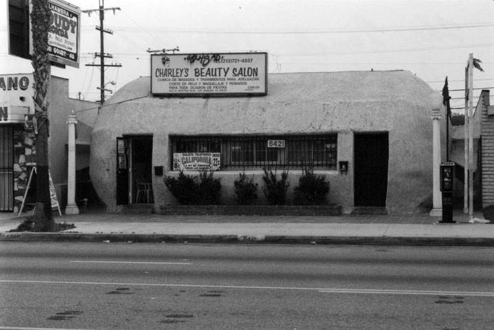
| (2001)* - View showing Charley's Beauty Salon, once the Tamale Restaurant, located at 6431 Whittier Boulevard. Photo by Milton Slade. |
Historical Notes The Tamale thrived into the mid-1980s before the restaurant closed and the building was repurposed—divided to house a beauty salon and a dental lab. Despite these changes, the building’s exterior remained mostly intact, even if painted over and modified. In 1994, it was listed on the California Register of Historical Resources, cementing its place as a rare and important example of L.A.’s vernacular roadside history. |
 |
|
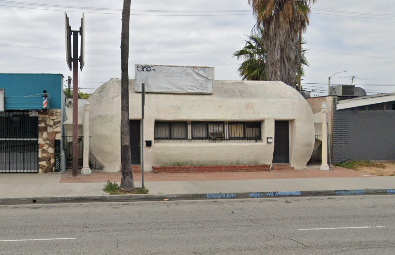
| (2024)* – Contemporary view of the 1928-built, programmatic-style building at 6421 Whittier Boulevard. Today, The Tamale still stands—vacant but physically intact. Its unique design continues to draw attention and affection from both locals and architectural enthusiasts. |
Historical Notes In the 2010s, preservationists grew concerned when the building went up for sale and became vacant. Campaigns to “Save The Tamale” gained momentum, and support from the community and even county officials helped highlight the need for stronger protections. Around 2016, the building received a modest facelift, but it remained unused. A new owner purchased it in 2018 with apparent interest in restoring it, though plans stalled, and the building later fell into tax delinquency, putting its future in question. |
Then and Now
 |
|
| (1928 vs. 2024)* – A 'Then and Now' view of the tamale-shaped building at 6421 Whittier Boulevard in East Los Angeles. The 1928 photo shows two young women sitting in the rumble seat of an early car parked across the street from The Tamale, a whimsical example of programmatic architecture. Nearly a century later, the building still stands—vacant but intact. Its distinctive tamale shape still catches the eye and continues to draw attention from both longtime locals and those who appreciate historic architecture. |
Historical Notes Today, The Tamale still stands, vacant but physically intact. Its unique design continues to draw attention and affection from both locals and architectural enthusiasts. As one of the last surviving examples of L.A.’s novelty architecture era, it remains a nostalgic symbol of the region’s cultural mix and roadside heritage. Preservation advocates are hopeful that, with the right support and vision, The Tamale can be restored and reactivated for a new generation to enjoy. |
* * * * * |
Toonerville Trolley Sandwich Shop
 |
|
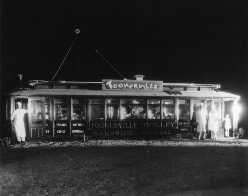
| (ca. 1930s)* - View of the Toonerville Trolley Sandwich Shop located at 1635 W. Manchester Avenue. Sign reads: 'Sandwich Special' and 'Free Coffee' |
 |
|
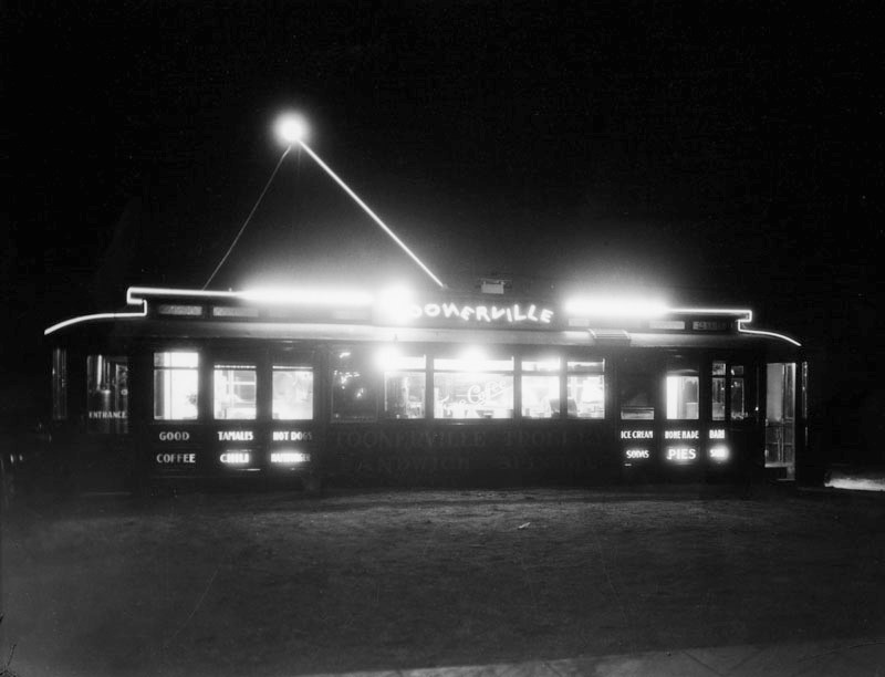
| (ca. 1930s)* - Night view of Toonerville Trolley Sandwich Special, housed in an old streetcar. Neon lights outline the roof of the car, as well as light on the advertising along the front panel that reads: "Good Coffee", "Tamales", "Chili", "Hot Cogs", "Hamburger", "Ice Cream", "Sodas", "Home Made Pies", and "Barbeque Sandwiches". |
 |
|
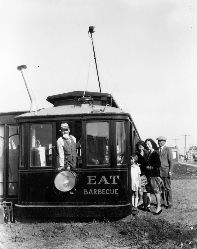
| (1930)* - Front view of the trolley, now Toonerville Trolley Sandwich Special, with a man looking out of an open window as several people wait outside to hop on. Advertising along the front reads: "Eat Barbecue". |
* * * * * |
Mushroom Café
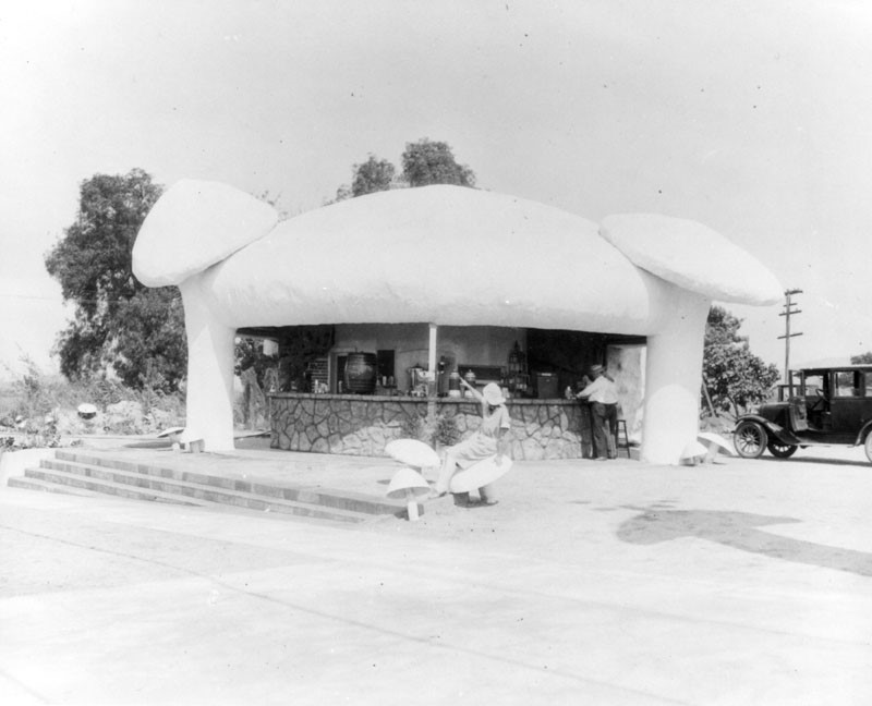 |
|
| (1920)* – View showing the Mushroom Café, in the shape of a mushroom, located at 3500 W. Olive Avenue in Burbank. A woman is sitting on a toadstool in front. |
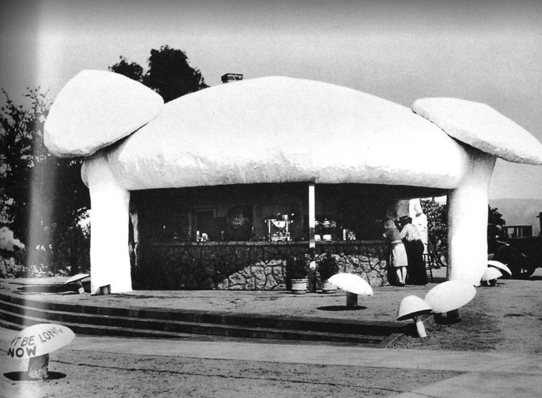 |
|
| (ca. 1928)* – Closer view of the Mushroom Café on Olive Avenue in Burbank. The small mushroom on the left has writing on it reading: "It won't be long now". |
* * * * * |
Toed Inn
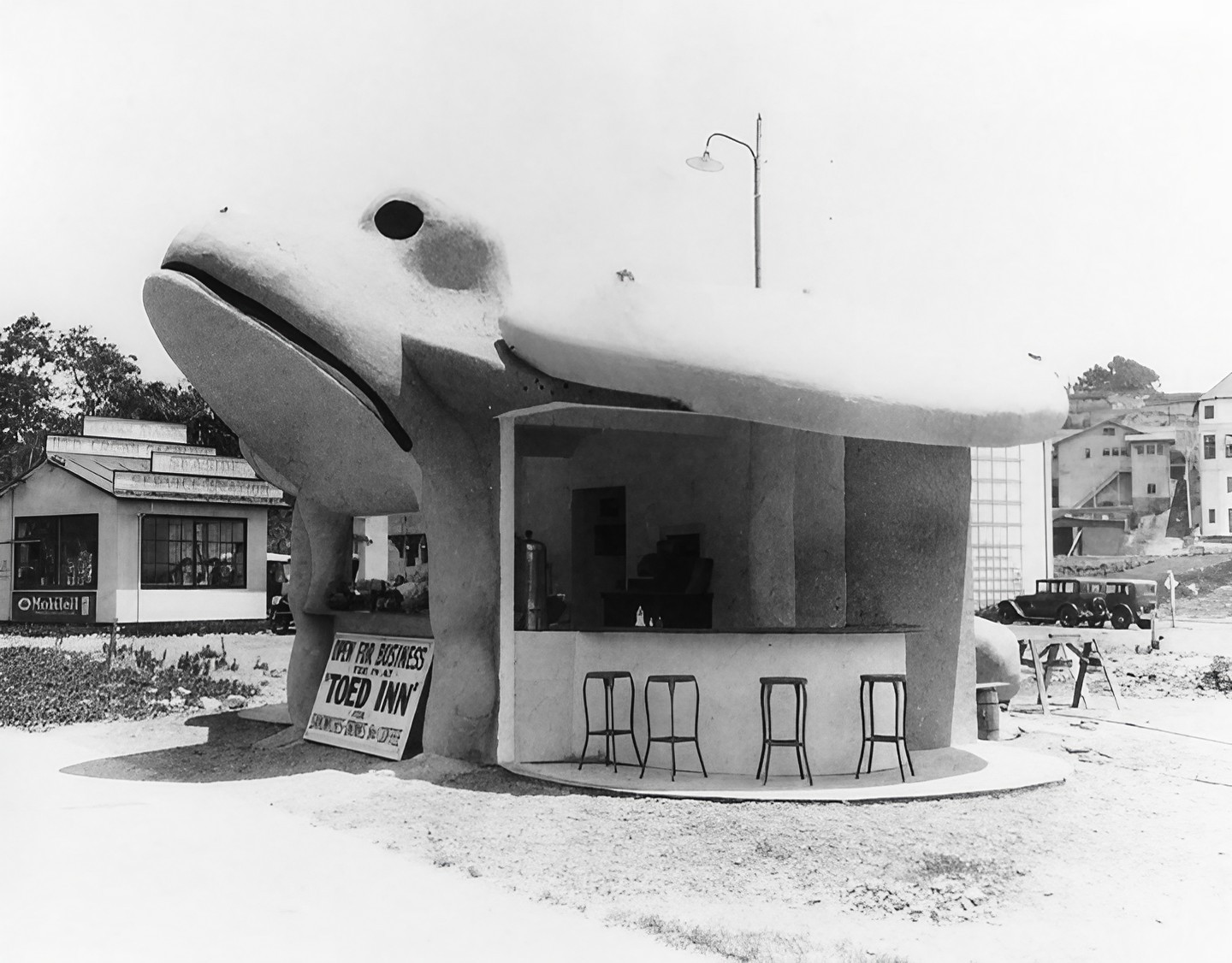 |
|
| (1929)* - The Toed Inn, was a stand in the shape of a toad, located on Channel Road in Santa Monica. Behind can be seen the Seaside Service Station. |
Historical Notes Opened in 1929 at 124 West Channel Road in Santa Monica Canyon, the original Toed Inn was a charming example of programmatic architecture—designed in the shape of a giant frog, with customers entering through its open mouth. Owned by Roger C. McGinn and designed by architect Jacob Lee Schimmer, the whimsical structure quickly became a roadside attraction for beachgoers and motorists alike. In 1931, the building was moved to a larger adjacent lot and expanded, but it met disaster in 1938 when a catastrophic flood damaged and partially buried the restaurant in mud, forcing it to close. |
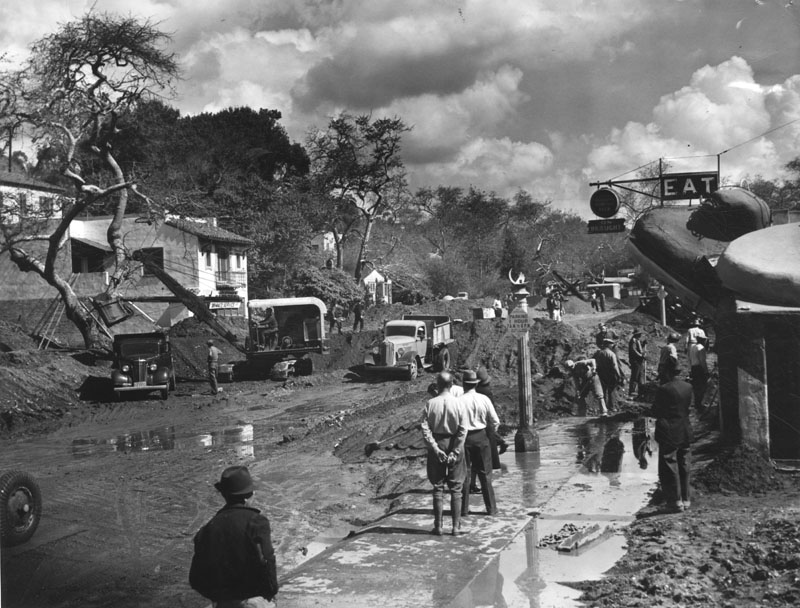 |
|
| (1938)* - Photo shows the cleanup of Channel Road in Santa Monica Canyon. Tons of mud and silt were deposited from the flood waters which raced down the canyon. The Toed Inn is on the right. |
Historical Notes In 1938, the Toed Inn structure was damaged by a flood caused by one of wettest seasons ever to hit Southern California. That same year the Toed Inn was relocated to West Los Angeles, at 12008 Wilshire Boulevard. |
 |
|
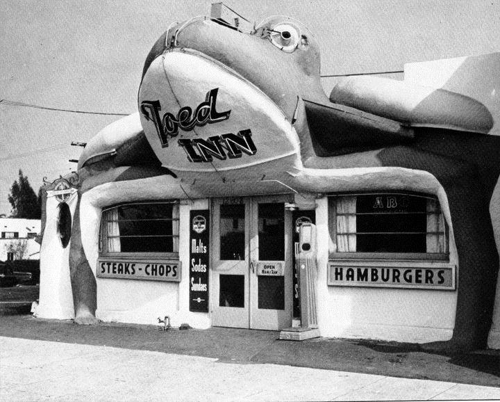
| (ca. 1939)* - The Toad Inn at it's new location at 12008 Wilshire Boulevard in West Los Angeles.. |
Historical Notes In early 1939, McGinn relocated the damaged frog structure several miles inland to 12008 Wilshire Boulevard, near Saltair Avenue in West Los Angeles. The front was rebuilt using accordion-style doors, and the restaurant reopened in a more enclosed and modernized form while still retaining its signature amphibian charm. The move positioned the Toed Inn along a major urban corridor, where it continued to draw attention with its fanciful design and playful theme. It was eventually sold to Benjamin Rosenfeld, who made further enhancements including neon signage and a new front façade. |
 |
|
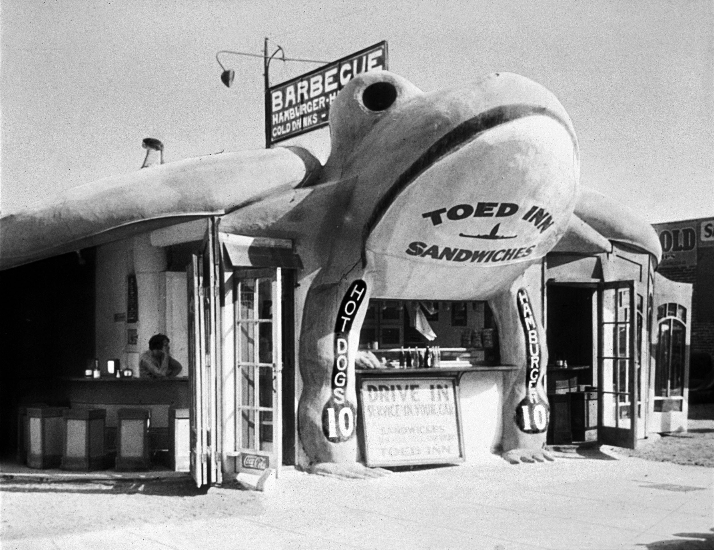
| (1940)* - Toed Inn located at 12008 Wilshire Boulevard after it became a drive-in restaurant. Click HERE to see more Early LA Drive-in restaurants. Photo from the Jim Heimann Collection. |
Historical Notes During the 1940s, the Toed Inn thrived as a drive-in restaurant, fitting perfectly into the car-centric culture of postwar Los Angeles. Known for hearty meals—steaks, barbecue, fried chicken, and even frog legs—it became a local favorite and was featured in publications like the Saturday Evening Post. However, by the early 1950s, novelty architecture began to fall out of favor, and the restaurant closed in 1953. The building was replaced with a more conventional establishment called Ben’s, but the giant frog lives on in L.A. lore as one of the city’s most endearing roadside oddities. |
* * * * * |
Pig Café
 |
|
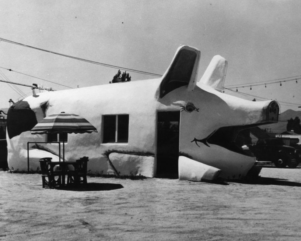
| (ca. 1934)* - The Pig Café, a pig-shaped fast food or sandwich shop was built in 1934 in Hollywood near La Brea Avenue and Rosewood Avenue. |
* * * * * |
Pup Café
 |
|
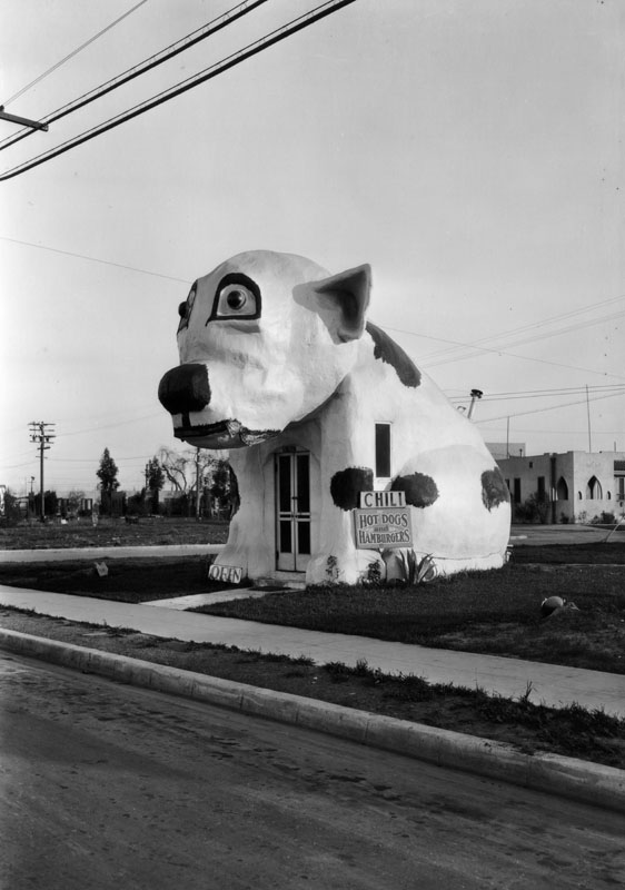
| (1930)* – The original Pup Café, a hot dog and hamburger stand built in the shape of a giant bulldog, is seen here at its first location: 5406 West Adams Boulevard in Los Angeles. |
Historical Notes The Pup Café began its life at 5406 West Adams Boulevard in Los Angeles. According to a building permit dated July 1929, Joseph Andrew Maddox moved an existing restaurant structure from an unspecified site within Los Angeles County to this location. Working with his sons, Maddox transformed the relocated building into a hot dog and hamburger stand featuring a whimsical, bulldog-shaped exterior. This early version of the café stood out as an example of "programmatic" architecture—an emerging trend in which buildings were designed to resemble the products or services they offered, in this case drawing attention with its oversized, cartoonish canine form. |
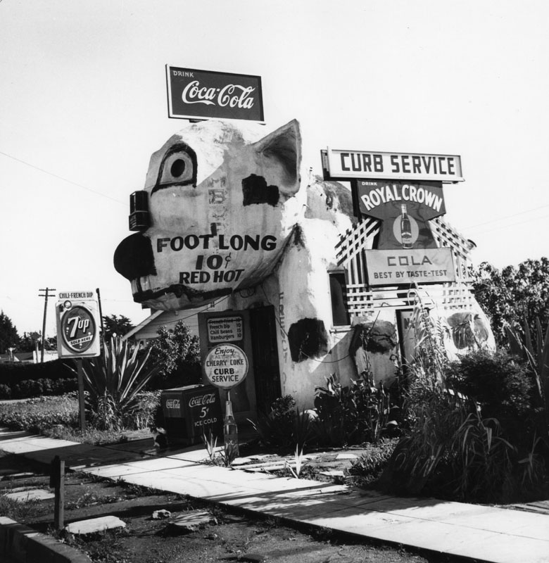 |
|
| (ca. 1940)* - The Pup Café at its second location at 12718 Washington Boulevard, just inside Culver City limits near Venice. The bulldog-shaped hot dog stand features bold hand-painted lettering advertising “Foot Long 10¢ Red Hots,” and a patchwork of Coca-Cola, Royal Crown, and 7-Up signs vying for attention. Photo by Ansel Adams. |
Historical Notes In 1933 or 1934, the Pup Café was moved to 12718 West Washington Boulevard, just within the Culver City limits but often associated with Venice due to its proximity to Zanja Street and Washington Place. Despite frequent mislabeling as 12728, the correct address was 12718. The café became a landmark of L.A.'s roadside dining scene during the height of the automobile boom. The structure likely disappeared by 1967, though some reports suggest it lingered as "Ugly Dog Records" into the late 1960s. |
* * * * * |
Bulldog Café (aka Builldog Inn)
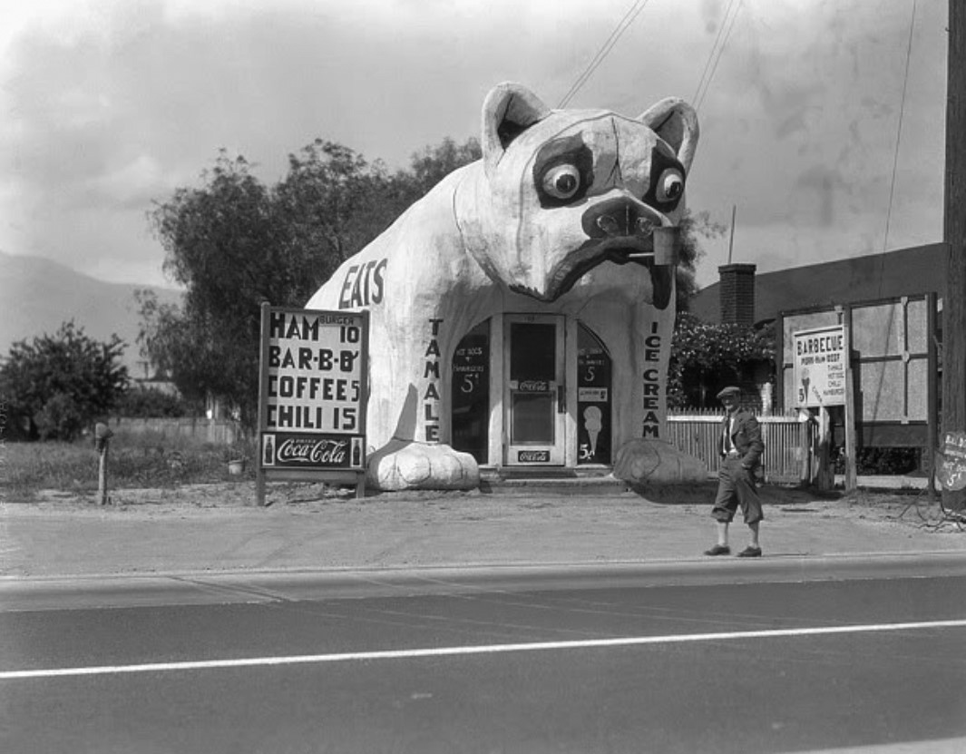 |
|
| (1933)* - A man in knickerbockers strolls past the Bulldog-shaped roadside café at 1153 East Valley Boulevard in Rosemead. Built by Everett Maddox, it served tamales, barbecue, chili, hamburgers, and ice cream. Though commonly referred to as the “Bulldog Inn” in at least one 1937 city directory, no formal name appears on the building itself—only bold signage advertising food. |
Historical Notes Often misattributed to West Los Angeles, the Bulldog Café was actually built in Rosemead in 1931. A 1937 city directory listed it as the “Bulldog Inn,” though no formal name appeared on the building. Its bold design mirrored the Pup Café, reflecting the Maddox family’s flair for whimsical architecture. The building was relocated around 1940–1944 to 638 East Garvey Avenue in Monterey Park, where it briefly served as a real estate office before disappearing by the late 1940s. The confusion over its location stems in part from early references in Jim Heimann’s California Crazy, which mistakenly linked the building to a similar address on West Washington Boulevard. Today, research confirms its true origin in the San Gabriel Valley. |
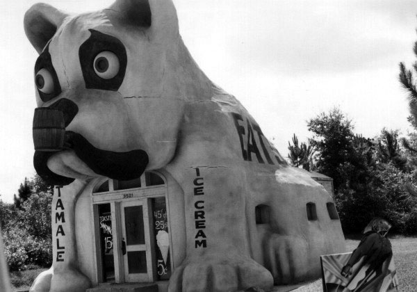 |
|
| (ca. 1990)* - View showing a replica of the Bulldog Café on display on the Disney-MGM backlot tour. |
Historical Notes In 1990, Disney recreated the Bulldog Café for the film The Rocketeer, and the full-scale prop was featured on the Disney-MGM Studios backlot tour from 1991 to 1996. Meanwhile, in 1994, the Petersen Automotive Museum—an example of programmatic architecture itself with its façade styled like a car grille—installed a smaller replica of the Bulldog Café inside. During a later renovation, the replica was slated for removal but was fortunately saved and now sits on the patio of the Idle Hour Café in North Hollywood, where it continues to honor the playful spirit of L.A.’s roadside architecture. |
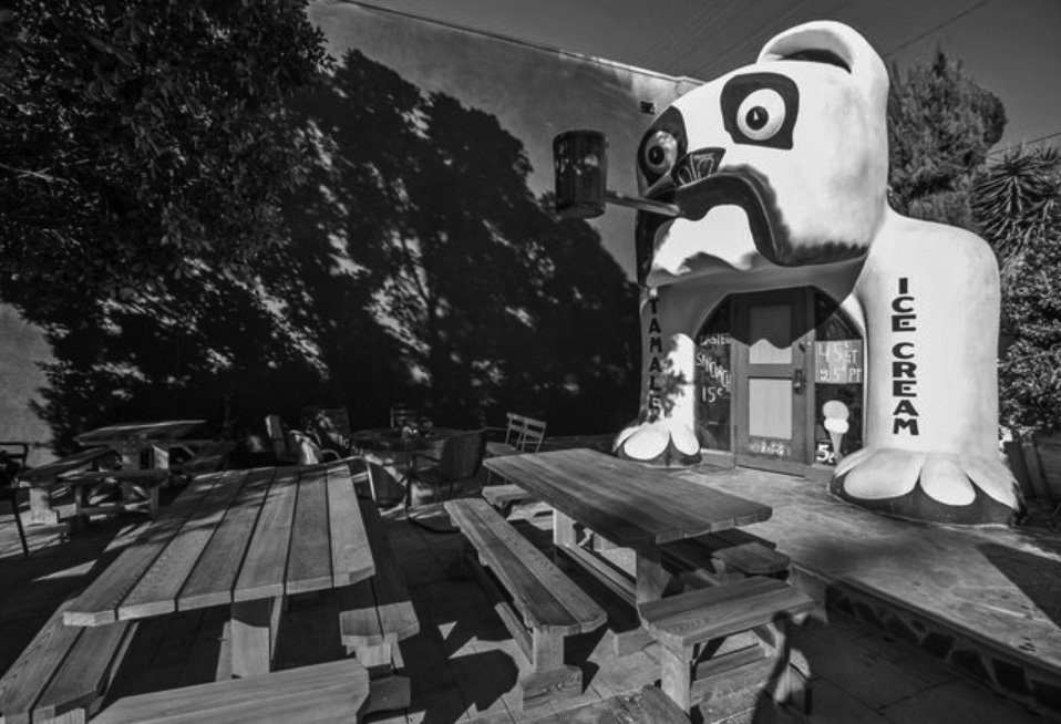 |
|
| (2015)* – View showing the replica of the Bulldog Café standing in the courtyard of the Idle Hour Café. Photo by Elizabeth Daniels |
* * * * * |
Chili Bowl Restaurant
 |
|
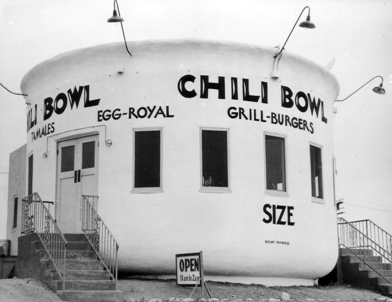
| (1937)* - View showing the Chili Bowl Restaurant, located at 3012 Crenshaw Boulevard. Writing on side of building reads: Tamales, Egg-Royal, and Grill-Burgers. |
Historical Notes Art Whizin established the Chili Bowl restaurant chain in Los Angeles in 1931, known for its distinctive shape in the form of a chili bowl. Whizin was a 25-year-old former amateur boxer when he established the business on Crenshaw Boulevard near Jefferson Boulevard with funding raised by selling "his wife's wedding ring and his roadster." Other businesses at the time were also modeled with architecture featuring eye-catching architectural depictions of the goods sold including ice a cream cones and coffee kettles. |
 |
|
| (ca. 1937)* - One of the six Chili Bowl restaurants, located at 801 N. La Brea Avenue. The neon sign mounted on the roof reads, "Get the Chili Bowl Habit!" Photo by Herman Schultheis |
Historical Notes Chili Bowl restaurants were arranged with 26 stools around a circular counter (no tables) and employed college "kids" as burger flippers. The specialty dish was an open-faced burger smothered in chili and there were 22 restaurants within a decade of the eatery's opening. After WWII many of the stores were converted into Punch & Judy Ice Cream Parlors that were later closed, and Whizin also built a mall in Agoura Hills that still bears his name. |
 |
|
| (1961)* - Exterior of Theater Ninety, located at 972 Vine Street at Willoughby Avenue (lower left). A Texaco service station is on the far right. This structure's shape and size give away its former life as a Chili Bowl restaurant; it has since been demolished. |
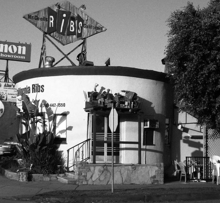
Historical Notes Four Chili Bowl structures survive, one in Huntington Park, Long Beach that is now the Guadalajara Nightclub, another became Kim Chuy Chinese restaurant on Valley Boulevard in Alhambra, the one on Pico Boulevard (that remained open 24 hours during the war effort for nearby workers), is now Mr. Cecil's California Ribs, and the one on San Fernando Road in Glendale is a used-car dealership. |
 |
|
| (2010)* - View of Mr. Cecil's California Ribs on Pico Boulevard in West L.A. in a former Chili Bowl building. |
* * * * * |
Pumpkin Building
 |
|
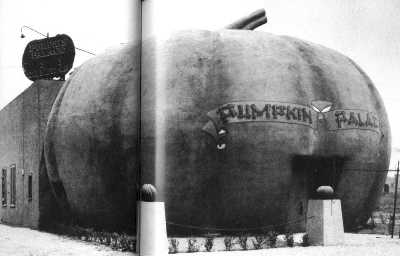
| (1927)* – View showing the Pumpkin Palace located at 3611 Magnolia Boulevard near Hollywood Way, in Burbank. |
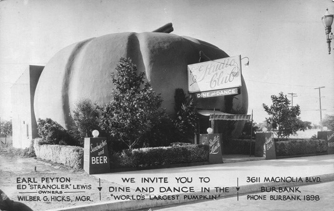
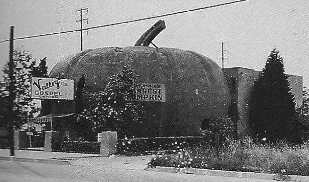
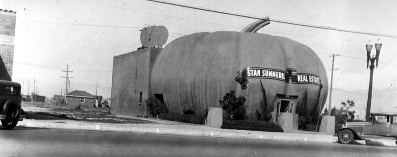
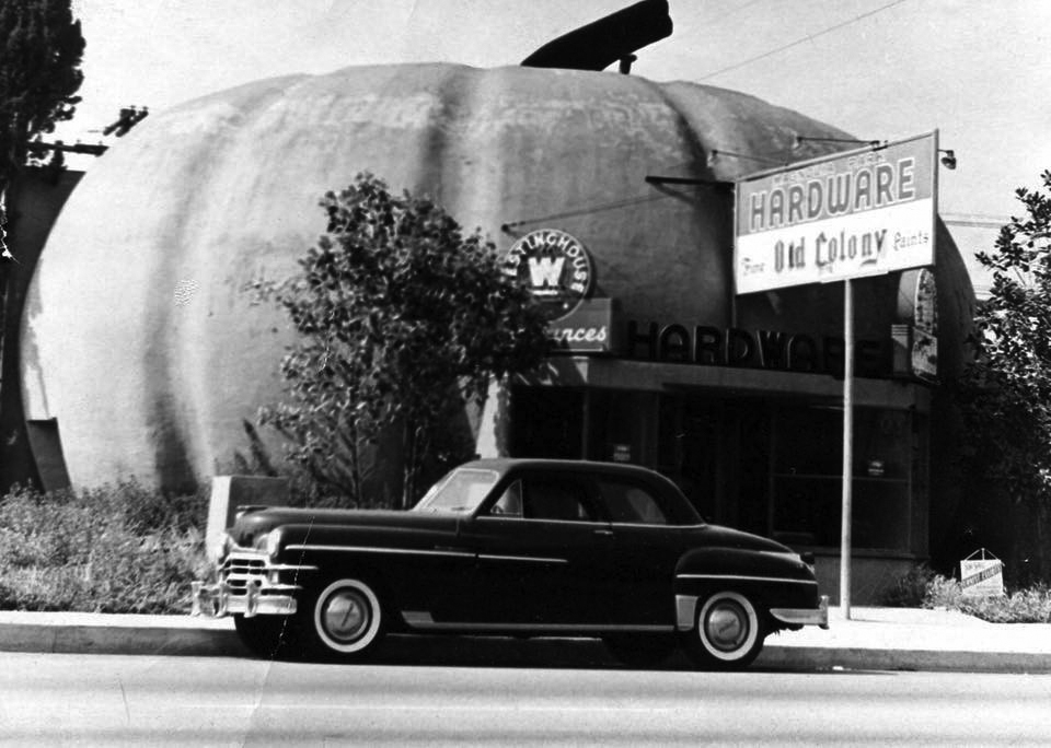
Historical Notes The Pumpkin Building would wear many hats throughout its existence. It started out as at least two nightclubs in the 1920s (Pumpkin Palace and Studio Club), later a church called Valley Gospel, an inn called the Pumpkin Inn, a real estate office called Stan Summeril Real Estate, and later a hardware store (Magnolia Park Hardware). |
 |
|
| (ca. 1930s)* - Postcard view of the Pumpkin Building now occupied by the Studio Club. Card reads: We Invite You to Dine and Dance in the 'World's Largest Pumpkin". |
 |
|
| (ca. 1935)* – The Pumpkin Palace after it was converted into a church called the Valley Gospel Center. |
 |
|
| (ca. 1938)* - The Pumpkin Building reincarnated as a real estate office called Stan Summeril Real Estate. |
 |
|
| (1950s)* - Another incarnation as a hardware store. Note the for sale sign in the lower right hand corner. |
* * * * * |
Brown Derby (Wilshire)
 |
|
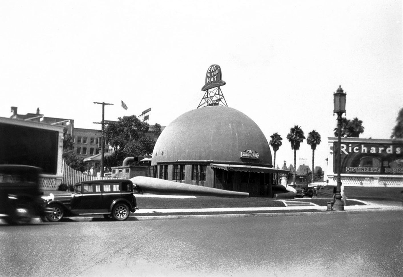
| (ca. 1926)* - View showing the original Brown Derby Restaurant located at 3427 Wilshire Boulevard between Mariposa and Alexandria avenues. |
Historical Notes The Brown Derby chain was started by Robert H. Cobb and Herbert Somborn (a former husband of film star Gloria Swanson). Bob Cobb is known as the inventor of the California Cobb Salad. He was also part owner of the Hollywood Stars baseball team. The original Brown Derby was built in 1926 on the site that later became the Chapman Park Hotel. It had to vacate its location on Wilshire between Alexandria and Mariposa when the land was requisitioned for the women’s village for the 1932 L.A. Olympic Games. So it was temporarily moved in 1931 five blocks west into the Bilicke Building located at 3927 Wilshire Blvd. In 1937, the Brown Derby would move out of the Bilicke Building into a newly constructed derby-shaped building at 3377 Wilshire Boulevard. The new location was a block east of the Derby's original home, on the northeast corner of Wilshire and Alexandria. |
 |
|
| (ca. 1940)* - Cars travel east down Wilshire Boulevard, where it crosses S. Alexandria Avenue (left), right outside the Brown Derby Restaurant. This was the second derby-shaped building of the Brown Derby. Built in 1937, it was located at 3377 Wilshire Boulevard (N/E corner of Wilshire and Mariposa), a block east of the Derby's original location. |
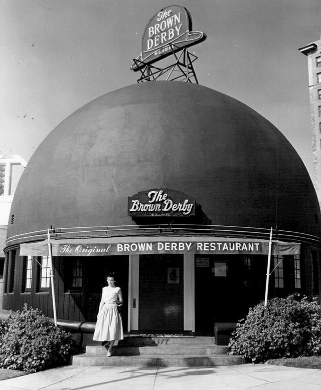
Historical Notes The derby-shaped building remains the most famous due to its distinctive shape. Whimsical architecture was popular at the time, and the restaurant was designed to catch the eye of passing motorists. It is often incorrectly thought that the Brown Derby was a single restaurant, and the Wilshire Boulevard and Hollywood branches are frequently confused. The Brown Derby chain also included restaurants in Hollywood, Beverly Hills, and the Los Feliz area. The Los Feliz Brown Derby at 4500 Los Feliz Blvd is the last remaining branch of the chain still extant and in operation*^ |
 |
|
| (1956)* - View showing the front entrance to “The Original Brown Derby Restaurant” on Wilshire Boulevard. |
Historical Notes After being sold in 1975 and renovated, the Brown Derby Restaurant on Wilshre Boulevard was finally replaced in 1980 by a shopping center known as the Brown Derby Plaza. The domed structure was incorporated into the third floor of the building and accommodates a cafe. A Korean mini-mall occupies the site today.*^ Click HERE for more historical background on the Brown Derby. |
* * * * * |
Round House Café
 |
|
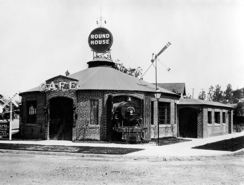
| (1929)* - View showing the Round House Café, located at 250 N. Virgil Avenue. This photo shows the main entrance, with a large "Café" sign above the door, and the front end of a locomotive peeking out from a "stall"; a large engine 'shed' is at the rear of the restaurant. The building is brick with a solid color roof, possibly red, which has a circular "Round House" sign on top. On the left, a 'railroad crossing' signal reads: "Stop. Look. Eat". Another sign below that advertises chicken, steaks, and ham. The operating hours are 5 P.M. to 2 A.M. |
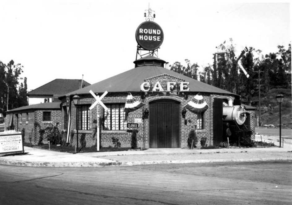
Historical Notes It advertised “The Squarist dinner in the Whole Round World for a Round Dollar at the Round House.” One could order a chicken, steak or ham dinner for $1.00 and have ice cream molded in the shape of a steam engine. |
 |
|
| (ca. 1930)* - The Round House, with a locomotive bursting from the building at the intersection of Temple, Virgil, Silverlake and Beverly . |
* * * * * |
The Oil Well Service Station
 |
|
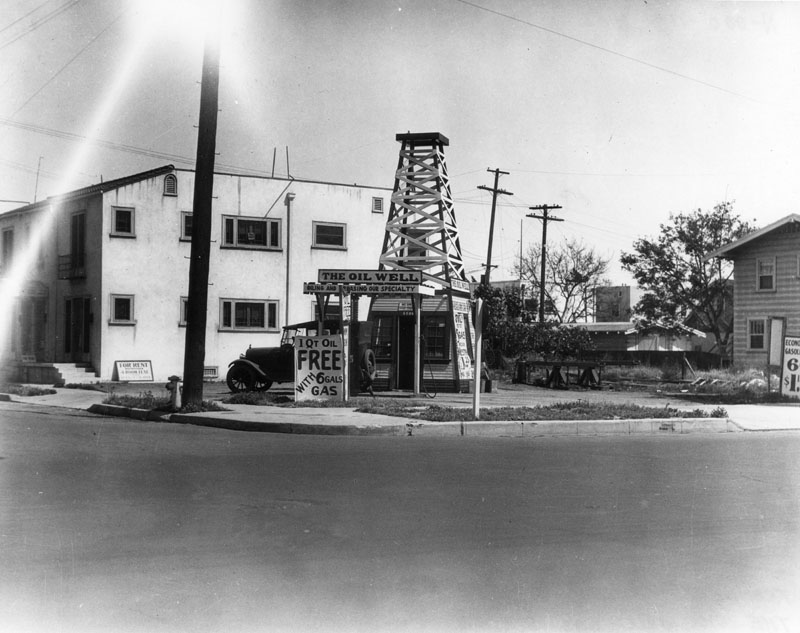
| (1920s)* - View showing The Oil Well service station offering 1 qt. oil, free, with 6 gallons of gas. |
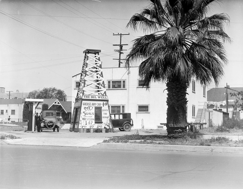 |
|
| (1920s)* - The Oil Well service station shaped like an oil well, next to a palm tree and a two-story apartment building in Los Angeles. Click HERE to see more Early Views of LA Gas Stations. |
* * * * * |
Bob's Air Mail Service Station
 |
|
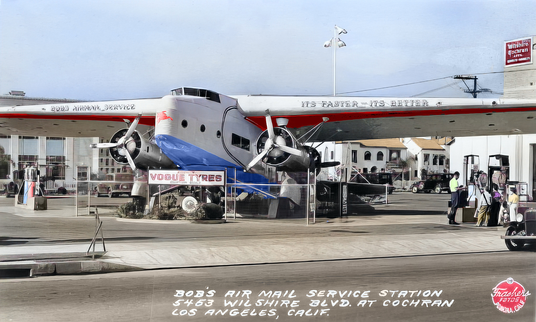
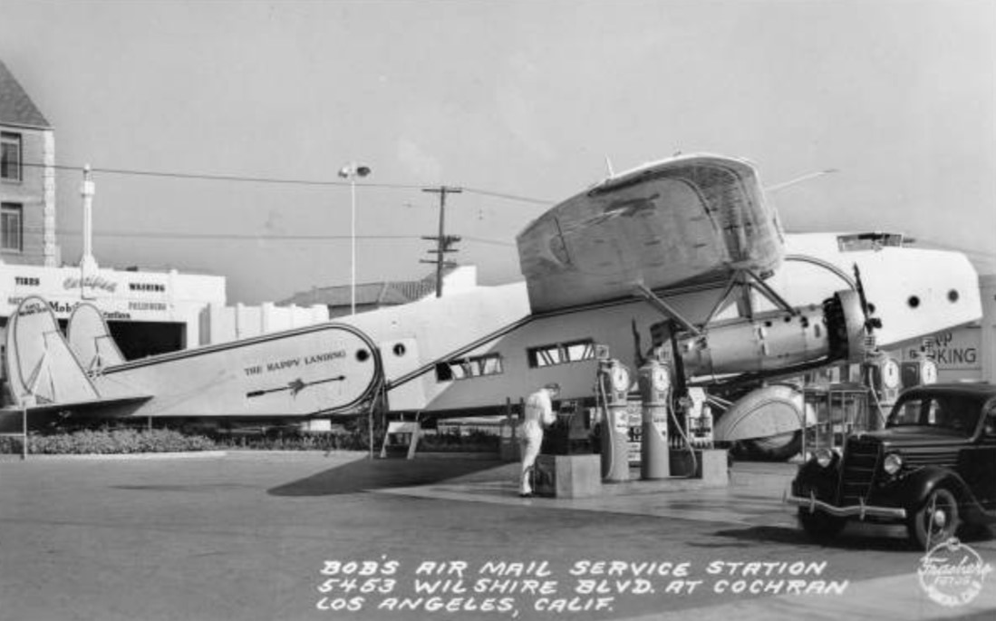
| (1935)* – View looking east on Wilshire Boulevard at Cochran Avenue. An airplane (Fokker F-32) seems to be parked on the corner lot. Sign on the wings reads: BOB'S AIRMAIL SERVICE |
Historical Notes Bob’s Air Mail Service utilized a real twin-prop airplane to top its station, with the wings serving as canopies to shade its General Petroleum pumps. The plane was one of two Fokker F-32 aircraft operated by Western Air Express, circa 1930-31. The four engine F-32 was a design failure due to overheating of the two pusher engines and was only briefly in commercial service. |
 |
|
| (1936)* - You could gas up your car beneath the wings of a grounded airplane at Bob’s Air Mail Service Station on the NW corner of Wilshire Blvd. and Cochran Ave. |
 |
|
| (1936)*- You could gas up your car beneath the wings of a grounded airplane at Bob’s Air Mail Service Station on the NW corner of Wilshire Blvd. and Cochran Ave. Image enhancement and colorization by Richard Holoff |
 |
|
| (1936)* – Postcard view showing Bob's Airmail Service Station at 5453 Wilshire Boulevard. |
Historical Notes Click HERE to see more in Early Views of LA Gas Stations. |
* * * * * |
Royal Albatross Service Station (Studio City)
 |
|
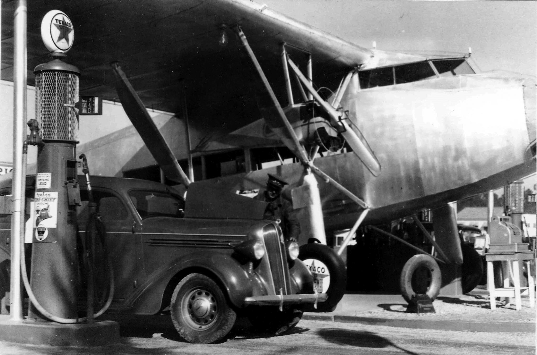
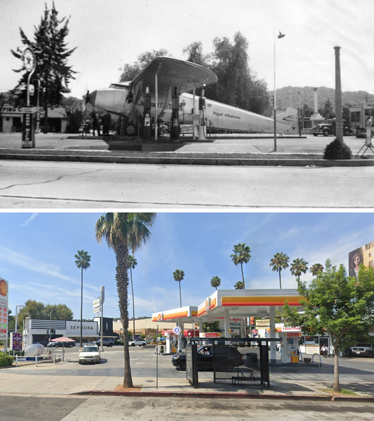
| (1939)^ - View of the Royal Albatross, an airplane used as a service station, located on the eastern vertex of a narrow strip of land bordered by Ventura Boulevard (south), Ventura Place (north, seen here, foreground) and Laurel Canyon Boulevard (west). Gasoline pumps are set up under the wing spans. |
Historical Notes The Zenith Model 12 didn’t work out too well. It was an attempt to travel on the success of Henry Ford’s trimotor. It was underpowered and not a roaring success. It became a one of a kind airplane. However, it wasn’t totally useless. Someone saw it as a gasoline station. It was set up as part of a Texaco station in the gore point created by the intersection of Ventura Boulevard and Ventura Place in Studio City opposite Republic Studios.^ |
 |
|
| (ca. 1939)^.^ - Close-up view showing an attendant servicing a car at the Royal Albatross Texaco Service Station in Studio City. Note the cash register on the right. |
Historical Notes History is vague but the Royal Albatross disappeared around the onset of WWII. |
Then and Now
 |
|
| (1939 vs 2022)* - Looking at the NW corner of Ventura Boulevard and Ventura Place showing a Shell gas staton where the Royal Albatross, an airplane used as a service station, once stood. |
* * * * * |
Big Red Piano Shop (aka. California Piano Supply Co.)
 |
|
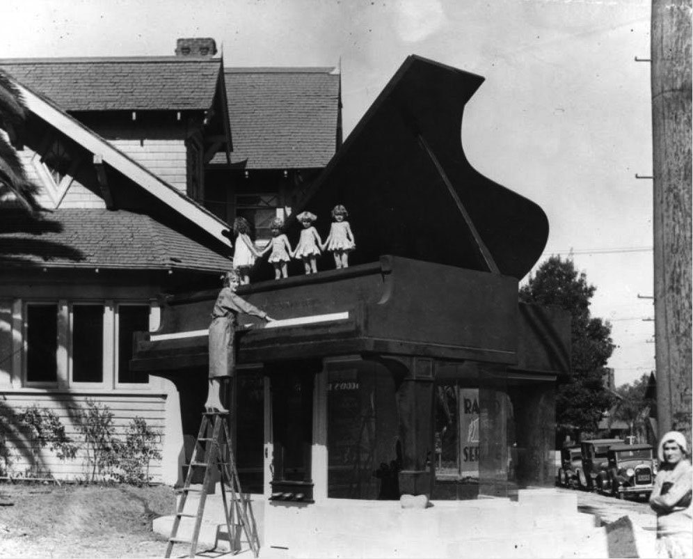
| (ca. 1930)* - A giant grand piano marks the entrance of the California Piano Supply Co. at 2251 Venice Boulevard at Oxford Street. Four little girls stand atop the piano while a women on a step ladder plays the giant keyboard. |
Historical Notes The Big Red Piano Shop, aka. California Piano Supply Co., was once located at 2251 Venice Blvd. (the corner of Venice and Oxford Street), near Western Avenue. A chiropractor named Dr. Ashley Manning first opened the California Piano Supply Co. in 1927. Because the neighborhood wasn’t an ideal location for a piano store, he relied on gimmicks to lure customers to his location. However, one of his attention grabbing ploys backfired in 1929, when he was arrested and sentenced to 30 days in jail after neighbors filed charges against him for playing his radio over loudspeakers at random times during the day and night. The sentence was suspended after he agreed to stop disturbing the peace. Around 1930, Manning added a large piano, measuring 40 feet high and 25 feet long, to the front of his store. Visitors had to walk under it to enter his showroom. |
 |
|
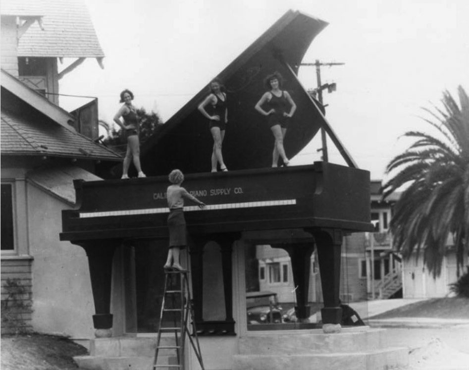
| (ca. 1930)* - Three bathing beauties stand atop an over-sized piano while a women on a step ladder plays the giant keyboard in front of the California Piano Supply Co., 2251 Venice Boulevard. |
Historical Notes The giant red piano received national attention, and became one of Los Angeles’s most recognizable icons of the 20th century. Ripley’s advertised it, and the New Yorker magazine once described it as “evidence of Southern California’s special brand of madness.” But Manning didn’t rely solely on his red piano to lure customers. He continued to host remote radio broadcasts, concerts, and free piano lessons for customers. |
 |
|
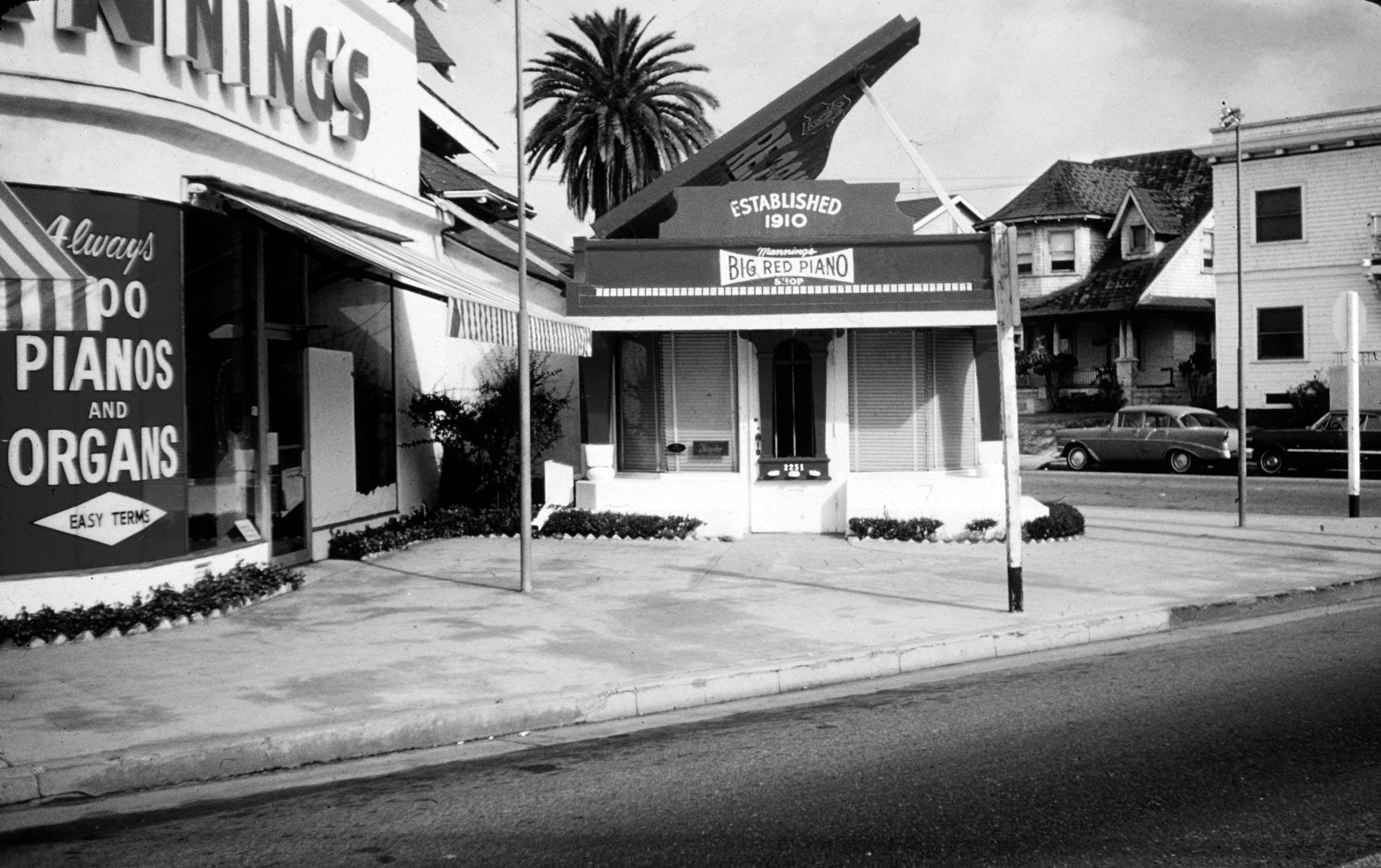
| (1977)* – View showing the Big Red Piano at 2251 Venice Boulevard on the NW corner of Venice Blvd and Oxford Ave. Today Charlie’s Fixtures occupies the main building. Click HERE for contemporary view. Image by Jim Heimann Collection. |
Historical Notes In 1966, Manning sold his business to another music company, who continued to operate it as Manning’s Big Red Piano Shop for four more years. The Refrigeration Equipment Co. then bought the property in 1970 and merged several buildings together to form a 150 foot showroom for its appliances. In 1972, a fire broke out in an adjacent wood-framed building that Manning once used as a repair shop, warehouse and office. Although the piano survived the fire, the Los Angeles Building and Safety Department declared that it had to be knocked down. In 1973, property owner Robert Taylor (not the movie star), tried to donate the piano to a historic and preservation organization, providing that the organization move the piano to a safe location. No organization accepted his offer. Eventually, a pop-architectural buff named Tom Sewell arranged for the piano to be moved 12 miles west to Venice, CA. The move was successful. However, when the contractor tried lowering the unsupported three-legged piano onto a new, specially-fitted concrete base, the piano broke into fragments and was lost. |
* * * * * |
Currie's Ice Cream
 |
|
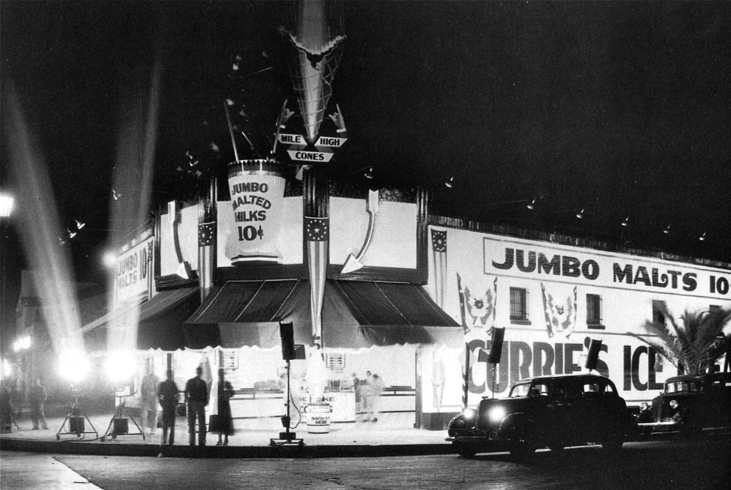
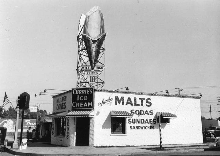
| (1930s)* – View showing what appears to be the Grand Opening of Currie’s Ice Cream Parlor on the NW corner of Wilshire Blvd and Gale Drive in Beverly Hills. |
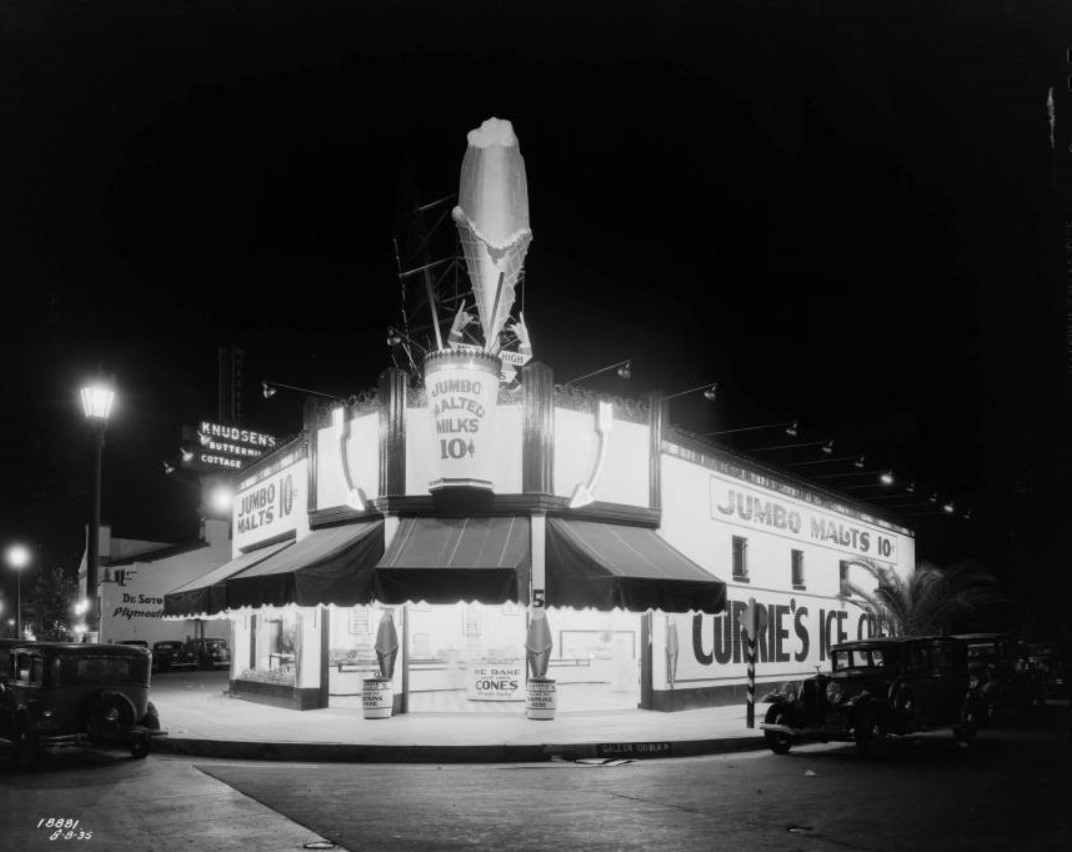
Historical Notes People still fondly remember the Currie’s chain and its “mile-high cone” whose replica was often displayed billboard-style on roofs. The chain was started in 1927 by three brothers named Kuhns. After WWII they sold it to the Good Humor Company who later sold it to Lipton in the 1960s. In 1964 the chain opened its 87th store, in North Hollywood. Although Currie’s anticipated launching units in every community in Southern California, only three outlets were listed in the 1967 Los Angeles phone book and the chain had disappeared by the 1980s. |
 |
|
| (1930s)* – View looking at a well-lit Currie's Ice Cream located at the northwest corner of Gale Drive and Wilshire Boulevard. Apparently, their 10 cent jumbo malts were the big thing—they mention it on all three sides of the building! Currie's was also known for its "Mile-High Cones". Click HERE to see contemporary view showing the same building. |
 |
|
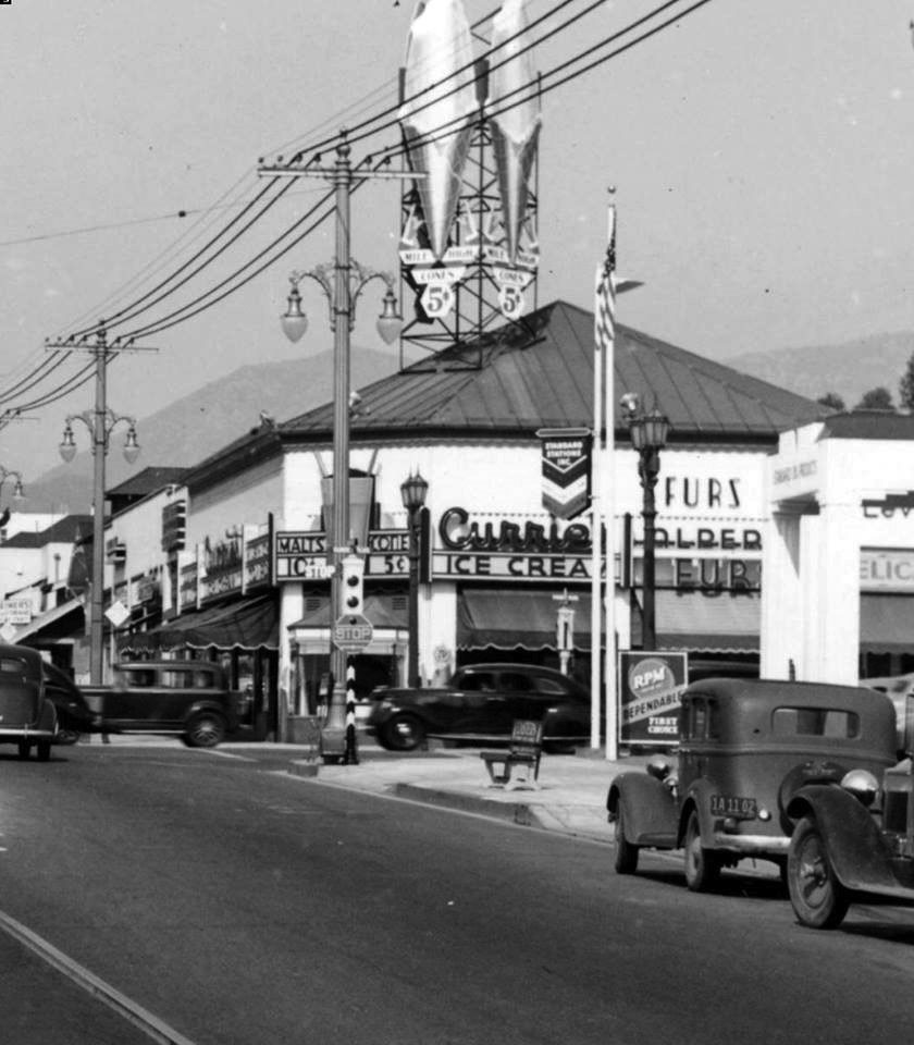
| (ca. 1936)* – View looking north on Highland Avenue toward Sunset Boulevard. Currie’s Ice Cream parlor is seen on the northeast corner with its Mile High Cone sign on the roof. |
 |
|
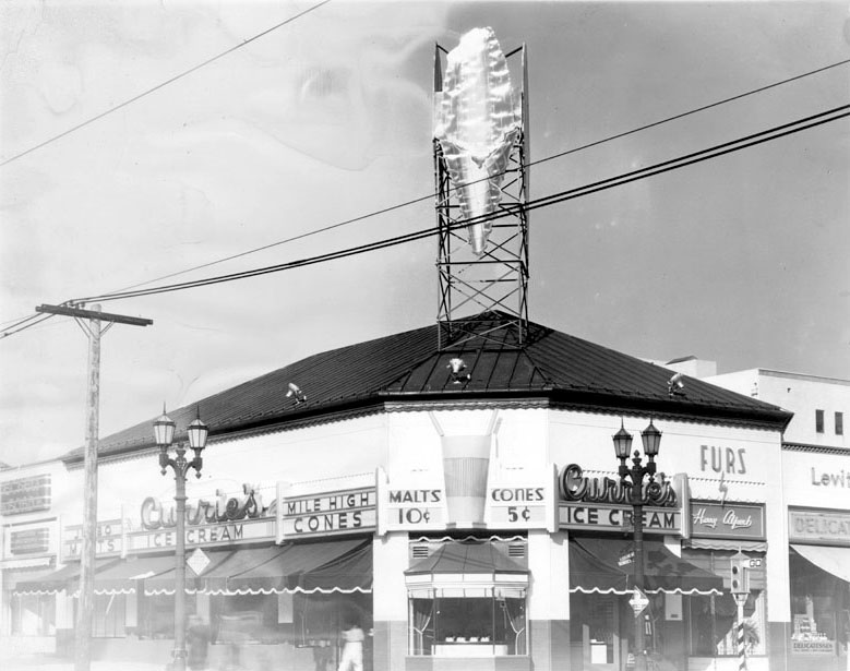
| (ca. 1940s)* - View of Currie's Ice Cream parlor on the northeast corner of Sunset Boulevard and Highland Avenue across the street from Hollywood High School. An enormous piece of metal in the shape of an ice cream cone is displayed on the roof. Signs above the awnings read, "Jumbo malts", Mile high cones", "Malts .10 cents" and "Cones .5 cents". The shop next door has a sign that reads, "Furs by Harry Alpert", and the one next to that is a delicatessen. This building has since been torn down to make way for other businesses. Click HERE to see contemporary view. |
 |
|
| (1945)* - View showing Currie's Ice Cream parlor located on the southwest corner of California Ave and Whittier Boulevard in the City of Montebello, Los Angeles County. Click HERE for contemporary view. |
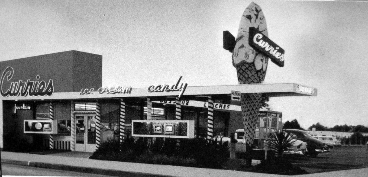 |
|
| (1950s)* - Curries Ice Cream & Candy located on the NW corner of Firestone Boulevard and La Reina Avenue in the City of Downey, Los Angeles County. Today, a Mexican restaurant stands at this location. Click HERE for contemporary view. |
* * * * * |
Kanteen - Mangnus Root Beer Restaurant
 |
|
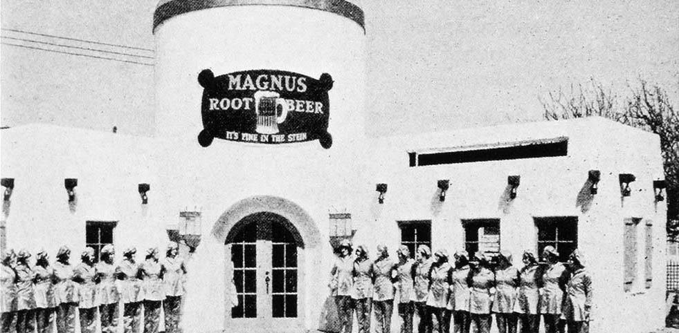
| (ca. 1929)* – View showing a Magnus Root Beer Drive-in restaurant located in Hollywood, likely near the corner of Waring Avenue and Vine Street. The center of the building was designed to resemble a giant beer stein, with the slogan “It’s fine in the stein.” The National Kanteen Company built a number of these distinctive Magnus Root Beer drive-ins across California, including two in Hollywood. |
Historical Notes Two Magnus Root Beer “Kanteen” restaurants were known to have operated in Hollywood in 1929. The location shown above is believed to be one of them—possibly the other Hollywood site built to the same design as the more documented Kanteen at 766 N. Vine Street (just south of Waring Avenue), where The Oinkster Restaurant stands today. The Oakland-based National Kanteen Company promoted these “Kanteen Stations” as a new type of quick-service, electrically powered roadside restaurant offering both booth and car service. An article in the Oakland Tribune (January 27, 1929) described them as “rapidly being built in various parts of California,” noting that each building was cylindrical in form and equipped with a ladies’ dressing room above. |
 |
|
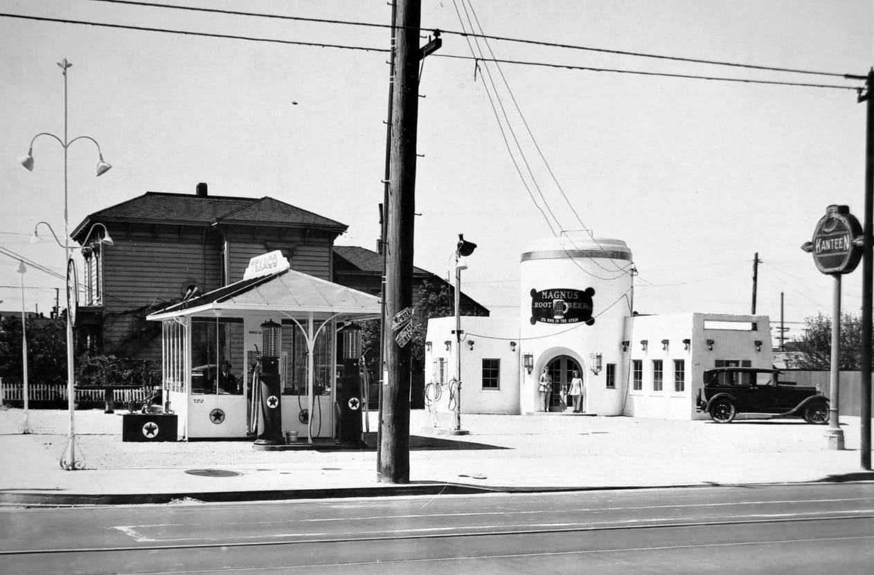
| (ca. 1929)* – View showing a two-pump Texaco gas station paired with a Magnus Root Beer “Kanteen” drive-in restaurant located at 766 N. Vine Street (just south of Waring Avenue) in Hollywood. The restaurant’s central structure was built in the whimsical shape of a giant beer stein with the slogan, “It’s fine in the stein.” Today, The Oinkster Restaurant occupies this same site. Click HERE for contemporary view. |
Historical Notes The Magnus Root Beer “Kanteen” seen here stood at 766 N. Vine Street, one of two such restaurants known to have operated in Hollywood in 1929. This location was paired with a Texaco gas station—an example of the era’s creative roadside combinations designed to draw motorists. The National Kanteen Company, based in Oakland, California, built a series of these distinctive Magnus Root Beer drive-ins in 1929. A January 27, 1929 article in the Oakland Tribune described the new chain of Magnus Root Beer “Kanteen Stations” as “rapidly being built in various parts of California.” Each building was cylindrical in form, with an upper level containing a ladies’ dressing room, and floor plans designed for counter, booth, and car service operated by a single server. The stations were advertised as being 100 percent electrically equipped using California-made equipment—an early reflection of the state’s push toward modern, efficient, and stylish roadside architecture. |
* * * * * |
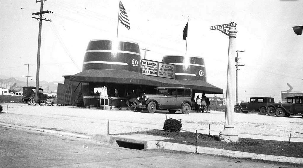
Twin Barrels Café
 |
|
| (ca. 1925)* – View showing the Twin Barrels Café located at 7227 Beverly Blvd, NE corner of Beverly and Alta Vista Ave. The sign in the middle shows they served hamburgers and sandwiches, chili and tamales, and a malts to wash it all down with. |
Historical Notes Click HERE for contemporary view of the NE corner of Beverly and Alta Vista where the Twin Barrels Cafe once stood. |
* * * * * |
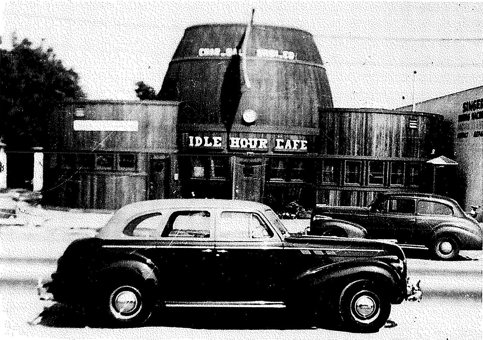
Idle Hour Café
 |
|
| (1941)* - View showing the Idle Hour Café the year it opend, located at 4824 Vineland Avenue, North Hollywood. |
Historical Notes Michael D. Connolly, the original owner/builder, was a film technician for Universal Studios, creating daily rushes for movie directors. In 1940, he acquired the land in North Hollywood for his Café and Tap Room, less than two miles from the studio. Connolly and his wife Irene would live above their new venture in a small apartment built into the head of the barrel, completed in 1941. On December 7, the United States was attacked at Pearl Harbor and Michael enlisted as a cook in the Merchant Marines. Upon his return he and Irene divorced. Irene continued running the café into the 1960s. Late in that decade it was renamed Rudy’s Keg. |
 |
|
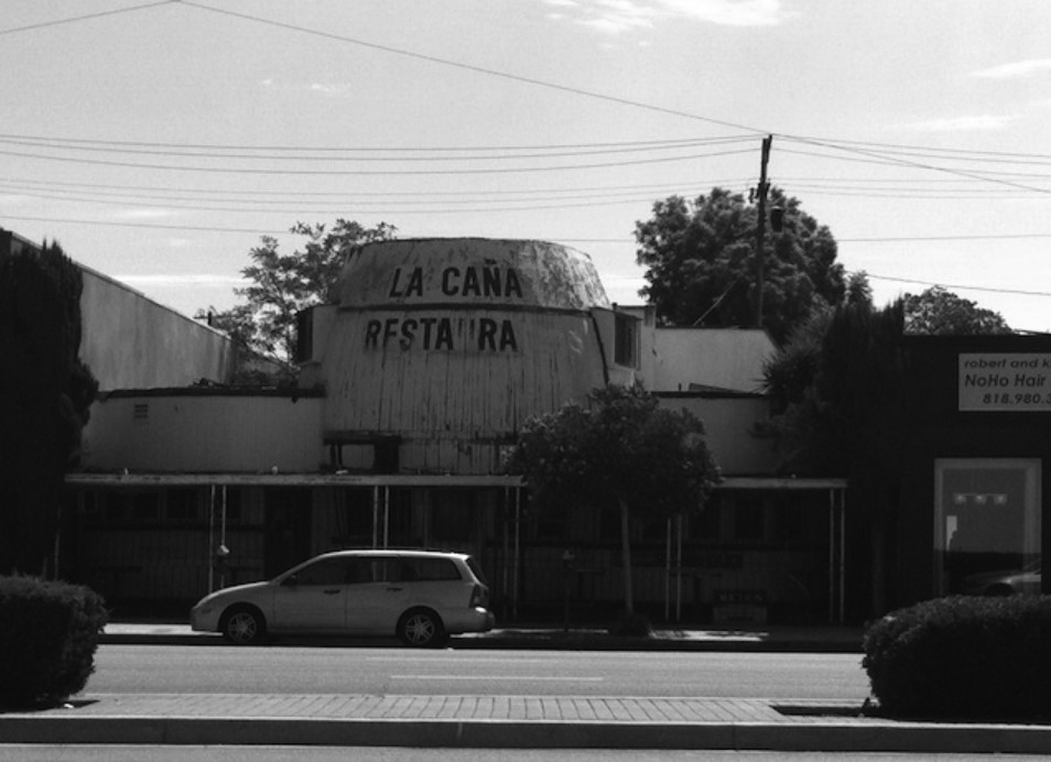
| (2011)* – View showing the La Caña Restaurant (Idle Hour Café), before its recent renovation. Photo by Lindsay William-Ross |
Historical Notes In 1971, the building was purchased by renouned flamenco dancers Jose and Dolores Fernandez. The pair redecorated the dining room to create a dinner theater called La Caña. The restaurant closed in 1984 but Dolores continued to live in the upstairs apartment until 2009. The building would be shuttered for over 27 years. |
 |
|
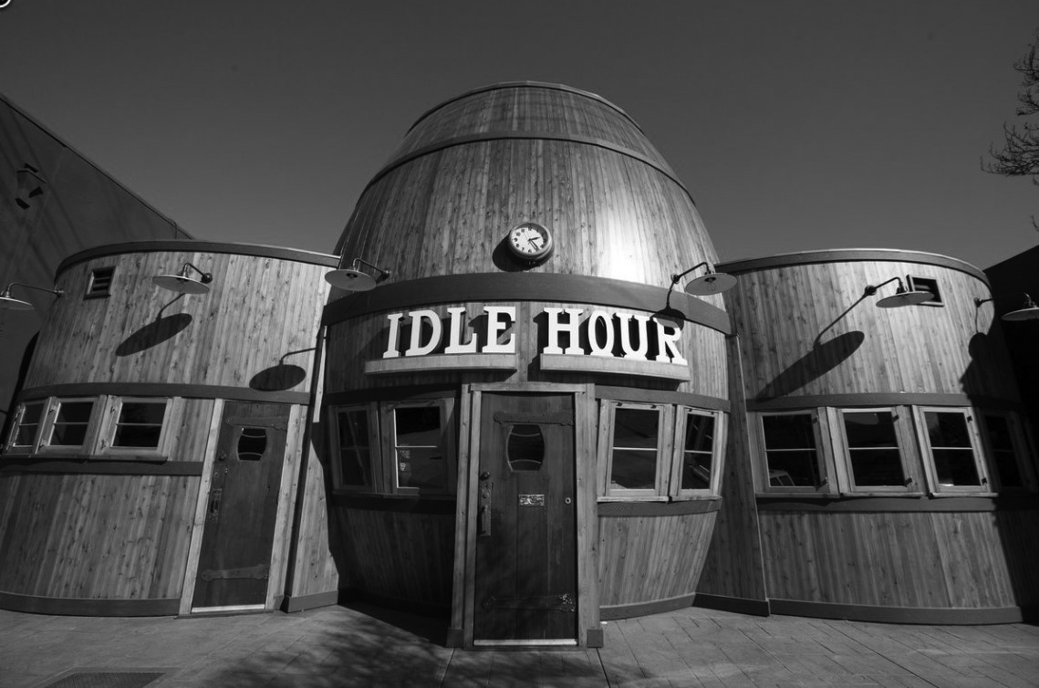
| (2015)* – View showing the newly renovated Idle Hour Café, located at 4824 Vineland Avenue. Photo by Elizabeth Daniels |
Historical Notes In 2010, the City of Los Angeles designated the Programmatic-style building Historic-Cultural Monument No. 977. The following year the "1933 Group" purchased the property and by 2015 the fully restored barrel-shaped building would once again open as the Hour Café. |
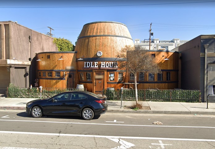 |
|
| (2023)* – Contemporary view of Idle Hour Café - 4824 Vineland Avenue. |
Historical Notes The barrel was actually once a more common type of mimetic architecture; local examples included The Barrel Inn, 1525 San Fernando, 1927; Twin Barrel Drive-in, 7200 Beverly Blvd., 1932, Giant Barrel, Los Angeles, 1935; as well as other exmaples around the country. The Idle Hour is the last remaining barrel-shaped structure in the Los Angeles area. |
* * * * * |
The Darkroom
.jpg) |
|
| (1970s)* – View showing the The Darkroom located at 5370 Wilshire Boulevard on the Miracle Mile. Photo by Marvin Rand |
Historical Notes Los Angeles is home to the original Darkroom. The shop, which is located at 5370 Wilshire Boulevard, was built under the direction of Marcus P. Miller in the 1930s at the height of the California Programmatic movement. The Darkroom camera shop is one of the most famous examples of mimetic or programmatic architecture. The Walt Disney Company recently built replicas of this building at their Hollywood, Paris, and Orlando amusement parks. While the freestanding neon letters were installed on a ledge above the Darkroom, the real sign was the facade itself. The storefront is a nine-foot-tall representation of a contemporary 35mm camera. The camera's body is faced with black Vitrolite glass and surrounded with glass block. Clear glass was used on both sides of the lens for display windows. |
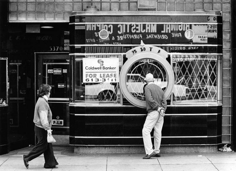 |
|
| (1981)* - Darkroom Camera Shop for lease. Two pedestrians pass the former camera store, The Darkroom, located at 5370 Wilshire Boulevard. The 1937 Art Deco building, designed by Marcus P. Miller, has been occupied by several businesses and restaurants since the camera shop closed. (Herald-Examiner Collection; Los Angeles Public Library) |
Historical Notes The real life inspiration behind the architecture is an Argus 35mm camera. |
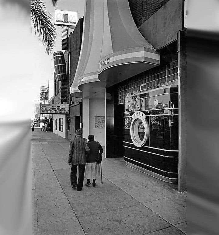 |
|
| (1992)* – An elderly couple walks past Boca Restaurant on Wilshire Blvd which was established as The Darkroom in 1938. |
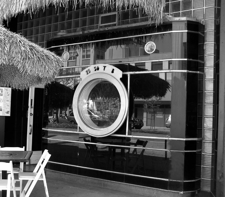 |
|
| (2010s)* – Close-up view of the Darkroom after being converted to a restaurant. |
Historical Notes The Darkroom closed in the late 1970s, and the building has since been used by several restaurants (El Toro Cantina, Punjab Cuisine, and La Boca del Conga Room). When it was occupied by El Toro Cantina, an aquarium was installed behind the storefront and swimming fish were visible (and still are) in the display windows from the street. |
 |
|
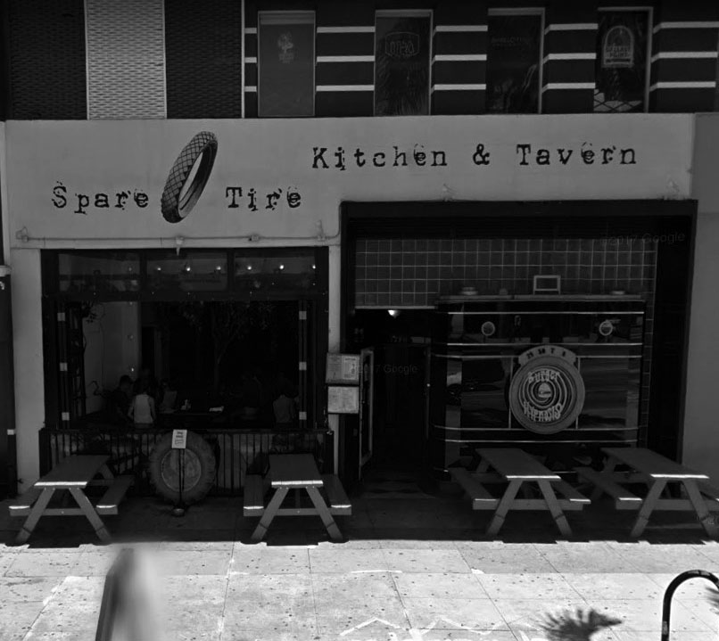
| (2017)* - View showing the Spare Tire Kitchen and Tavern (previously The Darkroom) located at 5370 Wilshire Boulevard, as it appears today, |
Historical Notes In 2014, the building's new occupant was the Spare Tire Kitchen & Tavern. The aquarium is still there. The facade itself is a protected landmark. Of the freestanding letters, all but the "K" were saved and are on display at the Museum of Neon Art in Los Angeles. |
* * * * * |
Shutter Shak
 |
|
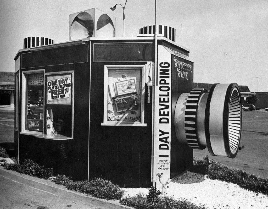
| (1970s)* – View showing the Shutter Shak, a photo developing kiosk in the shape of a camera located in the parking lot of a commercial center. |
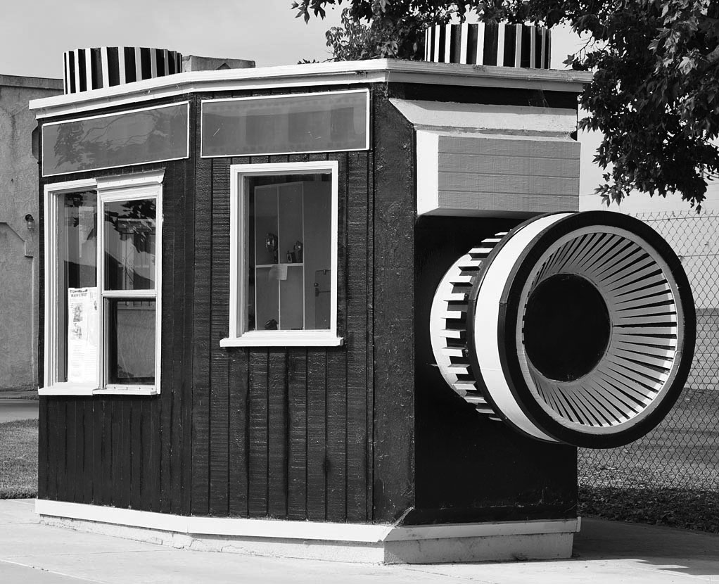
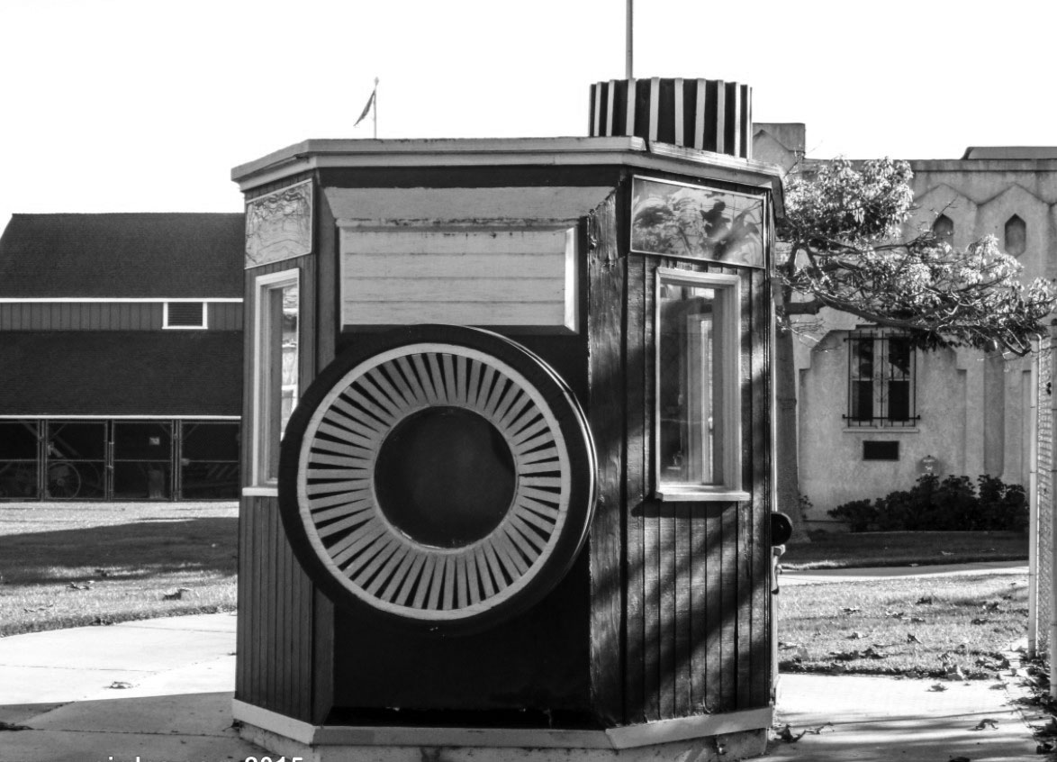
Historical Notes The Shutter Shak was originally built in 1976 and housed a photo developing business that advertised one day developing. Once located on 15336 Goldenwest Avenue, south of Bolsa Avenue, it has since been moved to the Blakey Historical Park on Westminster Boulevard and now houses a small camera museum inside it. |
 |
|
| (2010s)*– View showing the Shutter Shak building as it appears today. It functioned as a photo-developing business. The original flash cube on top of the building has been lost. |
 |
|
| (2014)* – View showing the Shutter Shak as it appears today at the Blakey Historical Park, operated by the Westminster Historical Society. Location: 8612 Westminster Blvd., Westminster, CA |
* * * * * |
Tail o' the Pup
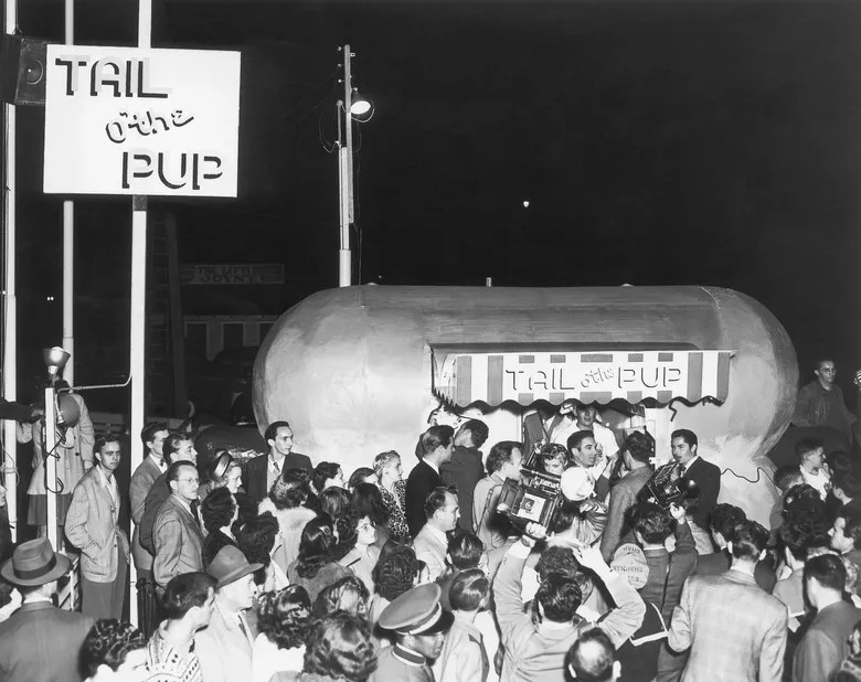 |
|
| (1946)* - Grand Opening of Tail o’ The Pup at 311 North La Cienega Boulevard. (AP Photo/File) |
Historical Notes Designed by architect Milton Black, the stand opened at La Cienega and Beverly boulevards in June 1946 to luminary-studded, searchlight-lit fanfare. Eddie Blake purchased the Pup in the early 1970s from its celebrity owners, the dance team of Veloz and Yolanda. |
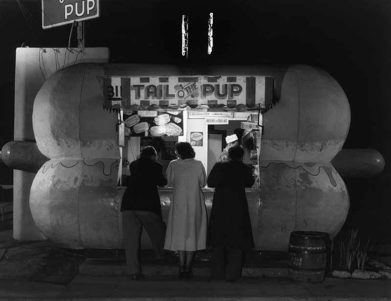 |
|
| (1949)* - Late night service at the Tail o' the Pup hot dog stand. |
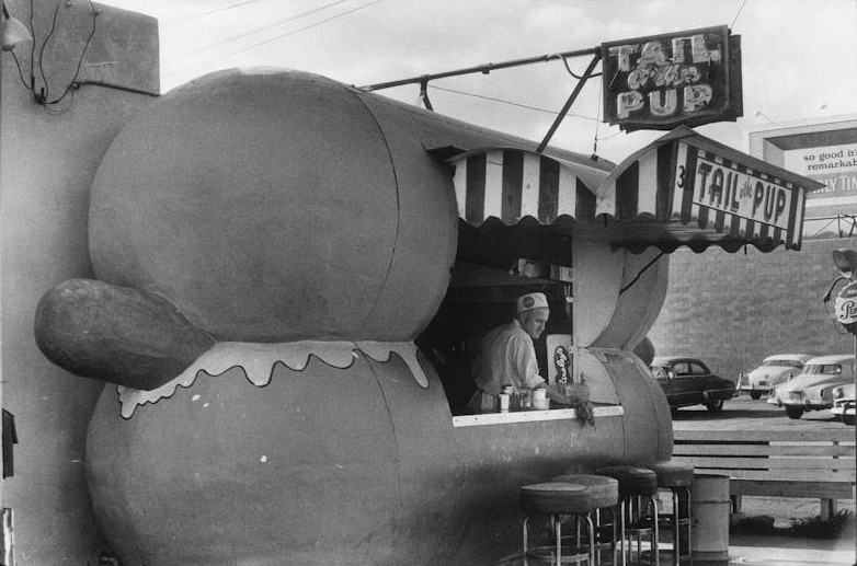 |
|
| (1957)* - View of Tail o' the Pup hot dog stand at its original location at 311 North La Cienega Boulevard. Courtesy of Vintage Los Angeles |
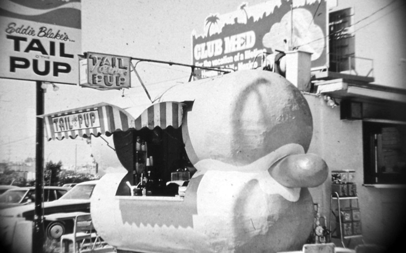 |
|
| (ca. 1963)* - Close-up view of the iconic Tail o' the Pup hot dog stand on La Cienega Boulevard. |
Historical Notes The Tail o' the Pup falls in the category of Programmatic-style Architecture, common in the 1920s to 1950s. These type of “hey-you-can’t miss-me!” buildings were made to pull automobile drivers right off the road. |
 |
|
| (ca. 1970s)* - Eddie Blake's Tail o' the Pup, famous hot dog stand at 301 N. La Cienega Boulevard in West Hollywood. |
Historical Notes Despite its appearance in countless movies and commercials, the stand faced demolition in the mid-1980s, creating an outcry that resulted in the stand being moved a few yards from its original location at 311 North La Cienega Boulevard, to 329 North San Vicente Boulevard. |
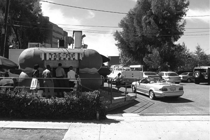 |
|
| (2005)* - Busy day for the Tail o' the Pup hot dog stand. This would be one of the last photos taken of the LA cultural landmark. |
Historical Notes In December 2005, the Pup was evicted and it moved into a Torrance warehouse after Regent Properties, a development company, purchased the Pup's site from landlord Cedars-Sinai Medical Center, and announced plans to build 152 condominium and apartment units. As of December 2012, construction had not started and the site remained a parking lot. Owners Dennis and Eddie Blake plan to reopen the Tail o' the Pup once a suitable location is found, possibly in West Hollywood. The City of Los Angeles has since declared Tail o’ the Pup to be a cultural landmark. |
* * * * * |
Fish Shanty
 |
|
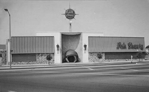
| (ca. 1960s)* - View showing Smith Bros. Fish Shanty restaurant on La Cienega Blvd. Photo courtesy of Vintage Los Angeles. |
Historical Notes The Fish Shanty, owned by the Smith Bros, was established on La Cienega in 1950. It was known to Los Angeles residents as "that place where you walked through the whale's mouth." The popular fish restaurant was anchored at the southwest corner of the La Cienega Boulevard, Burton Way, and San Vicente intersection in an area known as Restaurant Row. |
 |
|
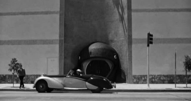
| (1965)* – View showing an early model car in front of the whale-mouth entryway of The Fish Shanty. Photo courtesy of Vintage Los Angeles. |
Historical Notes The above clip was taken from the British black comedy called The Loved One, starring: Robert Morse, Anjanette Comer, Rod Steiger, John Gielgud, and Liberace. The jaws of the Shanty’s whale façade was made out of thousands of tiny, ocean-blue, midcentury mosaic tiles that sparkled during sundown like the crest of an effervescent wave. |
 |
|
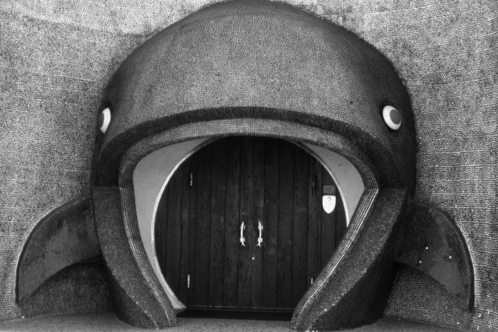
| (1980s)* - Exterior view of the entrance of the Smith Bros. Fish Shanty restaurant, showing a whale's mouth around the doors. The former seafood restaurant was located near the intersection of La Cienega Boulevard, San Vicente Boulevard and Burton Way in Los Angeles. |
Historical Notes The Fish Shanty was demolished after a fire during the early 90s and was replaced by a car dealership. Today a new apartment building has taken its place built by Rick Caruso that also includes a Trader Joe's. |
* * * * * |
Big Donut Drive-in (North Hollywood)
 |
|
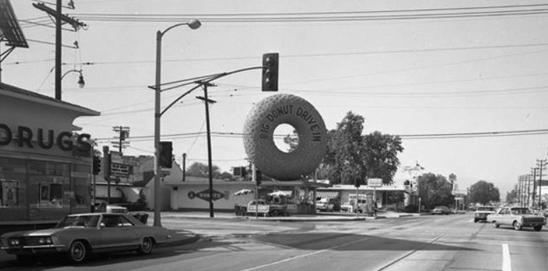
| (1960s)* - View looking north on Laurel Canyon toward Magnolia Boulevard where the Big Donut Drive-in stands on the northwest corner. |
Historical Notes Russell C. Wendell, a doughnut machine salesman, created the Big Donut Drive-in. There were 10 locations, built over the course of the 1950s. At least five Big Donuts survive: they are Kindle's Donuts in unincorporated Westmont (this is the original location, built in 1950), (2) Randy's Donuts in Inglewood near LAX, the Donut King II in Gardena (3), Dale's Donuts in Compton (5), and Bellflower Bagels in Bellflower (8). Each features the distinctive giant doughnut constructed of rolled steel bars covered with gunite, a material used in swimming pools. Five Big Donuts have been demolished. They were located in Culver City (4), North Hollywood (6), Inglewood, on Imperial Hwy, 7), Van Nuys (9) and Reseda (10). The building style dates to a period in the early 20th century that saw a proliferation of Programmatic Architecture throughout Southern California. This style had its heyday from the mid-1920s to the mid-1930s. By the 1950s however, the trend of designing structures in the shape of the product sold there had changed to focus on signs rather than architecture itself. |
 |
|
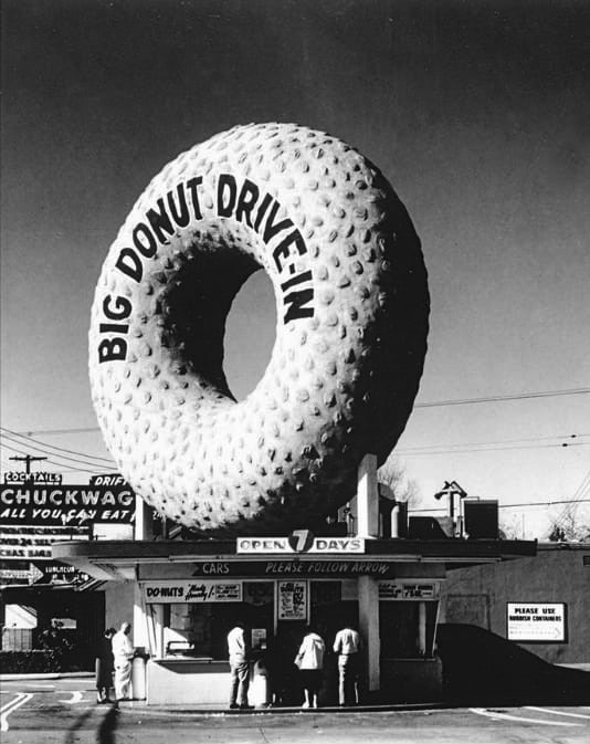
| (ca. 1960)* - Close-up view showing Russell Wendell's 6th of 10 Big Donut Drive-ins located on the NW corner of Magnolia Boulevard at Laurel Canyon Boulevard in North Hollywood. |
Historical Notes The donut shop was reportedly designed by Henry J. Goodwin as the second of ten locations for Russell C. Wendell’s now-defunct Big Donut Drive-In Chain, and was completed in 1953. Several others still survive, but this one (now Randy’s Donuts) is the best known. At least five Big Donuts survive: they are Kindle's Donuts in unincorporated Westmont (this is the original location, built in 1950), (2) Randy's Donuts in Inglewood near LAX, the Donut King II in Gardena (3), Dale's Donuts in Compton (5), and Bellflower Bagels in Bellflower (8). Each features the distinctive giant doughnut constructed of rolled steel bars covered with gunite, a material used in swimming pools. Five Big Donuts have been demolished. They were located in Culver City (4), North Hollywood (6), Inglewood, on Imperial Hwy, 7), Van Nuys (9) and Reseda (10). |
* * * * * |
Big Donut Drive-in (Reseda)
 |
|
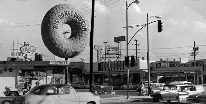
| (ca. 1959* – View showing Big Do-Nut Drive-in located at 7208 Reseda Boulevard on the NE corner of Reseda and Sherman Way. |
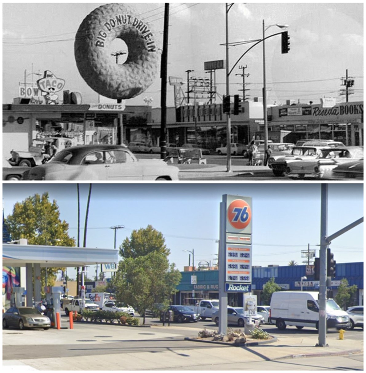
Historical Notes This location, the last to open in the Big Do-Nut chain, also had the smaller, 23-foot donut, mounted on a pole. The site is now a 76 gas station. Click HERE for contemporary view. Russel Wendell, who opened the 10 Big Do-Nuts in the Los Angeles area, went on to greater fame as the originator of the Pup ‘n’ Taco chain, whose first location opened in 1965. |
Then and Now
 |
|
| (1959 vs 2023)* - Big Do-Nut Drive-in located at 7208 Reseda Boulevard on the NE corner of Reseda and Sherman Way, today the location of a Union 76 gas station. |
* * * * * |
Randy's Donuts
 |
|
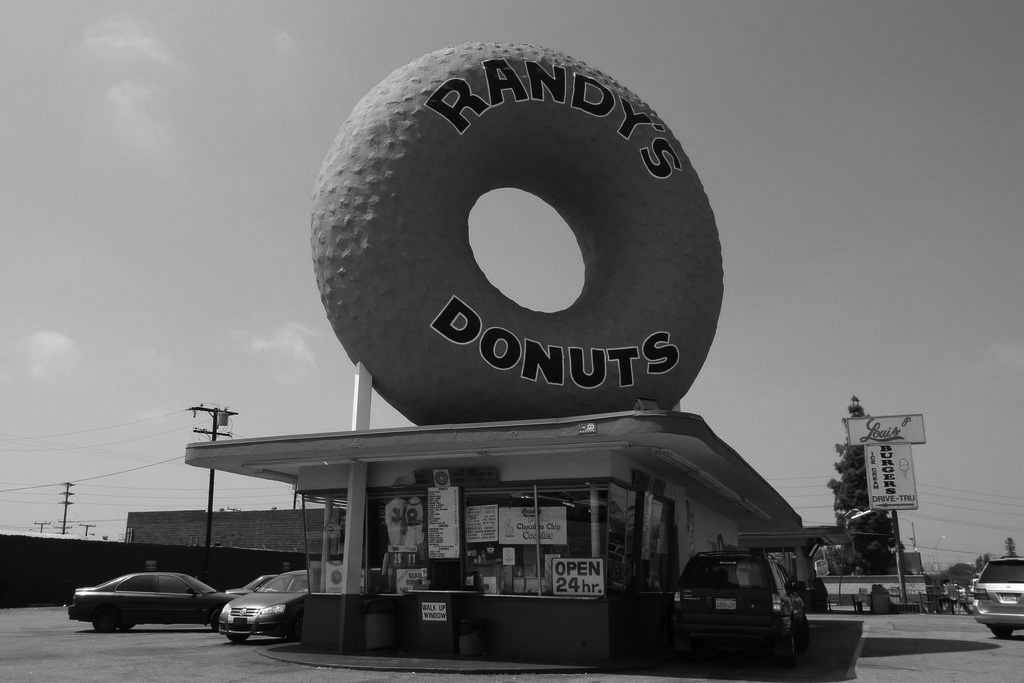
| (2009)* - View showing Randy's Dunuts (originally Big Donut Drive-in) located at 805 West Manchester Avenue in Inglewood (near LAX). "OPEN 24 hrs" |
Historical Notes Randy’s Donuts is an unquestionable icon of 1950s Los Angeles, for obvious reasons: it is a typical mid-century drive-up restaurant with a giant donut on its roof. Not just a giant donut—Randy’s has THE giant donut, the most famous donut in America and maybe even the world. It has appeared in innumerable television shows, music videos, and films. The donut shop was reportedly designed by Henry J. Goodwin as the second of ten locations for Russell C. Wendell’s now-defunct Big Donut Drive-In Chain, and was completed in 1953. Several others still survive, but Randy’s in Inglewood is the best known. The building itself is a fairly unremarkable if admirably intact Mid-Century Modern drive-up food stand, and it may not technically count as Programmatic architecture (in which a building looks like the item it hawks). But the donut on its roof is just so large, so uncompromising, so demanding of our attention that we’ll look the other way and consider Randy’s a Programmatic design. |
 |
|
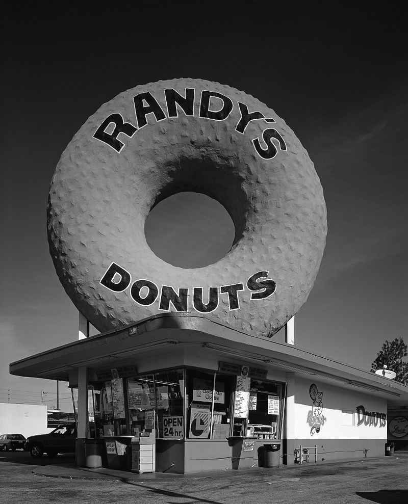
| (2004)* – View showing Randy's Donuts, colloquially known as "The Big O". The donut shop was made famous by the 32.5-foot donut on its roof. Photo Credit: Library of Congress |
Historical Notes The restaurant has seen three owners: 1) Russell Wendell, who created the Big Donut Drive-in chain in the 1950s; 2) Robert Eskow who purchased it in the mid-1970s and made it part of his Randy’s chain of sandwich shops; 3) Ron and Larry Weintraub who took over in 1978 (Weintraubs and Eskows are related). |
* * * * * |
Kindle’s Donuts
 |
|
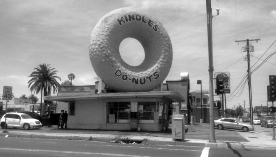
| (2014)* - Kindle’s Donuts at Normandie and Century Blvd in South Central L.A. originally was the first Big Donut location, built in 1950. |
Historical Notes In 1950, in a burst of post-war enterprise, a young doughnut machine salesman named Russell C. Wendell opened a small store on S. Normandie and Century Blvd in South Central L.A. which he called the Big Donut Drive-in. In order to get attention he mounted a gigantic doughnut on the roof, measuring 32 ½ feet in diameter. It was made of rolled steel bars, covered with gunnite, a material used in building swimming pools- basically mortar sprayed through a hose at ultra-high velocity. He painted his Big Donut name across the front and Boom! Instant business success. This Big Donut is still in existence, having gone through many ownership changes. It was re-named Kindle’s in 1977 when a baker named Gary Kindle purchased this location. It has kept its second name even though the owners have since changed. |
* * * * * |
The Donut Hole
 |
|
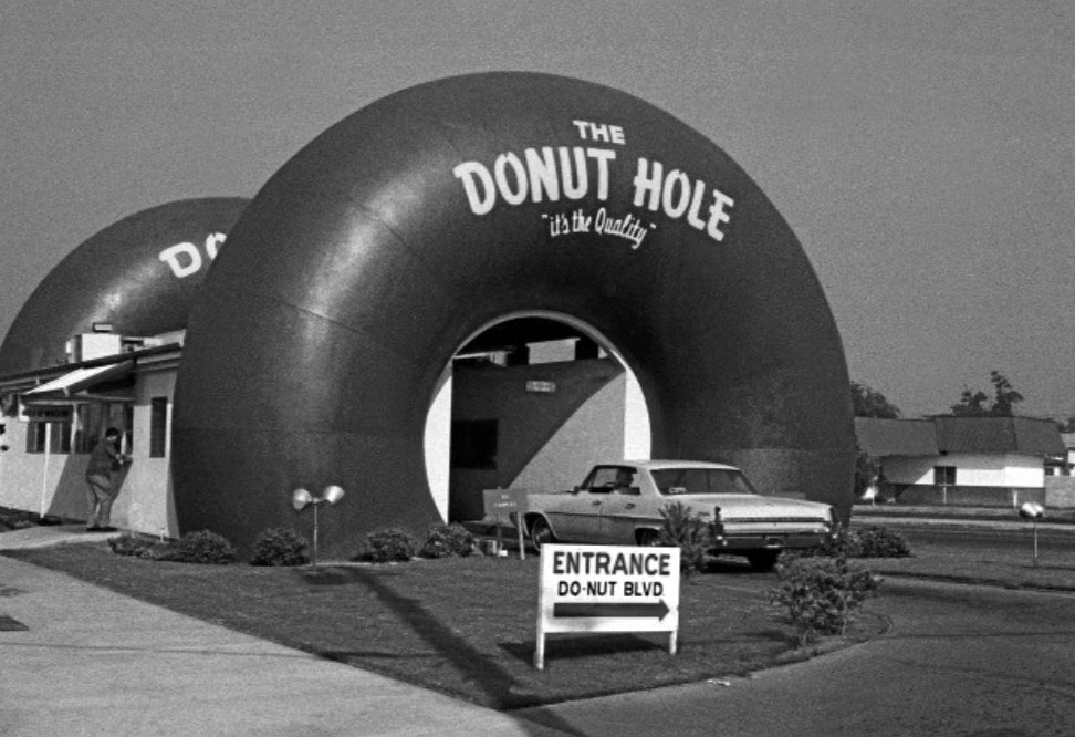
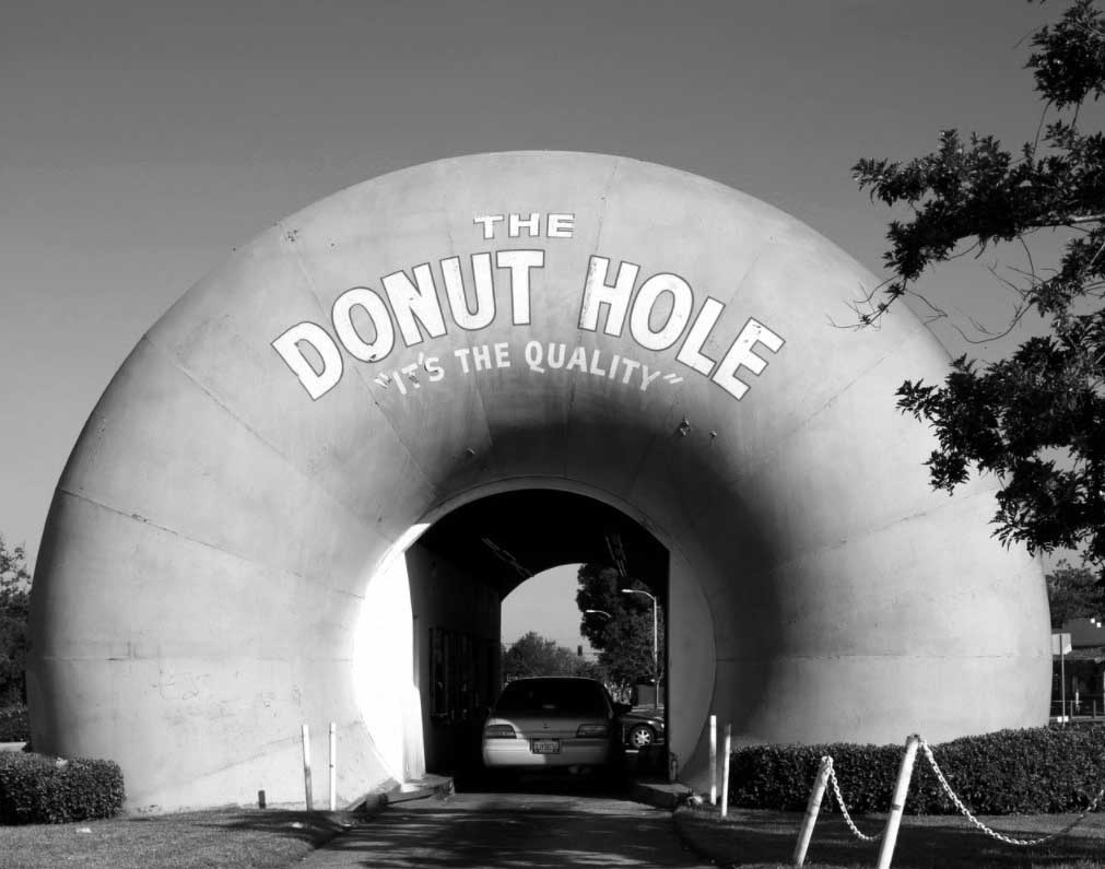
| (1970)* – View showing the Donut Hole, a drive-through coffee and donut shop in an eye-catching building located at 15300 Amar Road, La Puente in LA County. Sign reads: 'Entrance - Do-Nut Blvd'. |
Historical Notes The first Donut Hole opened in 1963, in La Puente, California. According to one source, the shop in La Puente was the second to open, in 1968, and was followed by three others. However, various sources disagree and date the building's original construction from 1947 to 1958 to 1962. What is certain is that the donut chain went out of business in 1979. |
 |
|
| (ca. 2006)* - View showing the entrance to the The Donut Hole drive-through stand in La Puente in Los Angeles County. Photo by Carol M. Highsmith |
Historical Notes The La Puente Donut Hole was purchased by the Lopez family in 1979 and remained in the family until 2003. The Covina branch was completely remodeled and the others were demolished, and only the La Puente location remains today as a working bakery. Click HERE for another Contemporary View. |
* * * * * |
Studio City Hand Car Wash
 |
|
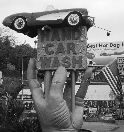
| (2008)* - View showing the Studio City Hand Car Wash located at 11514 Ventura Boulevard. The 3-dimensional sign features a giant hand holding a square sponge with a ’57 Corvette Convertible on top of it. |
Historical Notes The sign was created by sculptor Gagik Daniel in 1998 and features a life-sized replica of a 1957 hot pink Corvette sitting on top of a giant yellow sponge held by a slightly larger-than-life fiberglass hand. |
 |
|
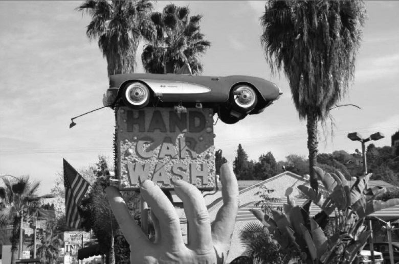
| (2010s)* - View looking southeast showing the famous Studio City Hand Car Wash sign (which features a giant three-dimensional hand holding up a classic car). Photo courtesy of Shel Weisbach |
Historical Notes The imaginative eye-catching signage survived despite the opposition of the Studio City Residents Association and the City of Los Angeles. The sign was too tall (6 ft.) and too close to the street (8½ ft.), and built without a permit. To remedy the situation, the sign was moved and its height reduced by slicing the wrist. |
 |
|
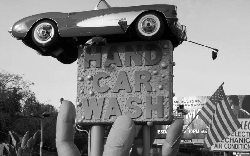
| (2014)* – Close-up view of the Studio City Hand Car Wash sign with American Flag attached to one of its giant fingers. Location: 11514 Ventura Boulevard - Los Angeles Magazine |
Historical Notes Studio City Hand Car Wash, with its famous 3-dimensional sign, is now an institution on Ventura Boulevard. Click HERE for contemporary view. |
* * * * * |
Crossroads of the World
 |
|
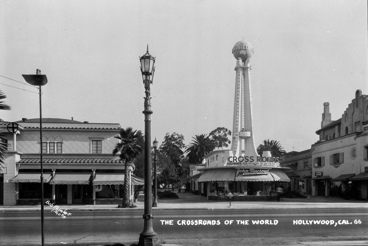
| (1936)* - Postcard view looking north across Sunset Boulevard showing Crossroads of the World. Photo Bob Plunkett |
Historical Notes Designed by local architect Robert V. Derrah, Crossroads of the World is one of Los Angeles' most recognizable properties. The Hollywood complex was completed in 1936 and conceived as a cosmopolitan shopping center featuring merchandize from around the globe. Oriented around a centralized Streamline Moderne structure, Crossroads of the World was envisioned as a hub of pedestrian activity. The complex features a programmatic nautical theme, paired with architectural styles found around the world. |
 |
|
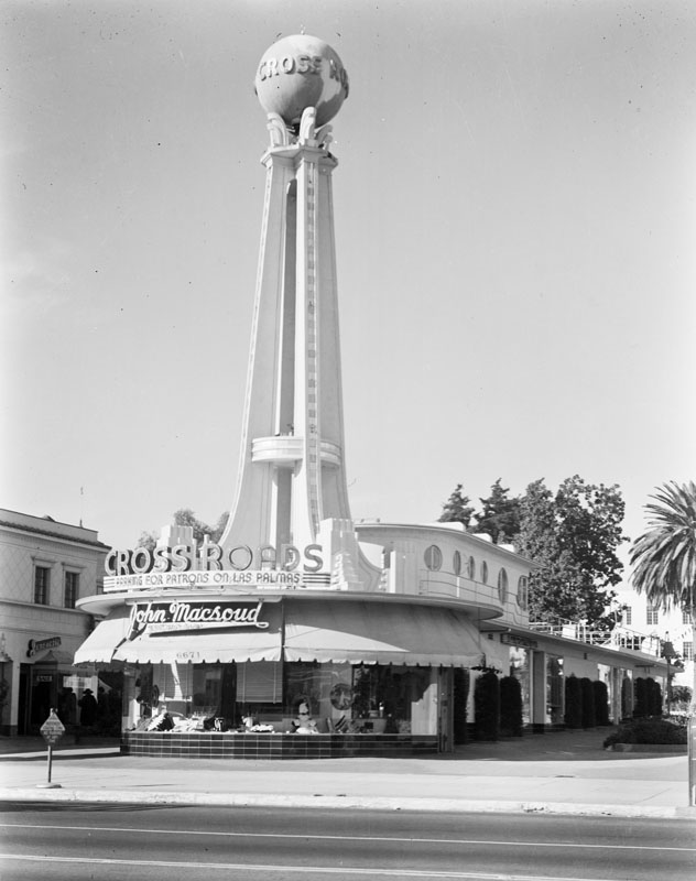
| (1939)* - Entrance to the Crossroads of the World shopping center designed to look like a Streamline Moderne ship. It has a tall, open tower that is topped with a lighted globe. In the foreground is the John Macsoud shop, located at 6671 Sunset Boulevard in Hollywood. |
Historical Notes In addition to Crossroads, architect Robert V. Derrah was responsible for a number of significant commissions in Los Angeles during the 1930s. Many of his buildings were designed in the Streamline Moderne style, including the Coca-Cola Building (1939). He also designed an addition to John and Donald Parkinson's Southern California Gas Company Complex (1942) and contributed to the Fairfax Farmers Market (1934). In the 1940s and '50s, Crossroads began its transition from shopping center to office complex, housing such tenants as the Screen Actors Guild, Standard Oil, and American Airlines. In January 2019, the Los Angeles City Council approved a project to revamp the Crossroads of the World in a move to revitalize the district. Three high-rise buildings are planned to bring 950 apartments and condos, a 308-room hotel, and 190,000 square feet of commercial space. Preservationists called the redevelopment project a "Manhattanization of Hollywood". Eighty-two Hollywood Regency garden apartments are to be demolished in the project.These rent stabilized apartments are occupied by a decades-old, tight-knit community of largely low-income, predominantly Latino residents. Over 100 apartments in the project will be set aside for very low-income families. Click HERE to see more Early Views of Crossroads of the World. |
* * * * * |
Coca-Cola Building
 |
|
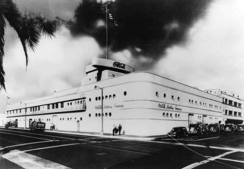
| (1939)* - Exterior view of the Coca-Cola Bottling Co. of Los Angeles at 1334 South Central Avenue. |
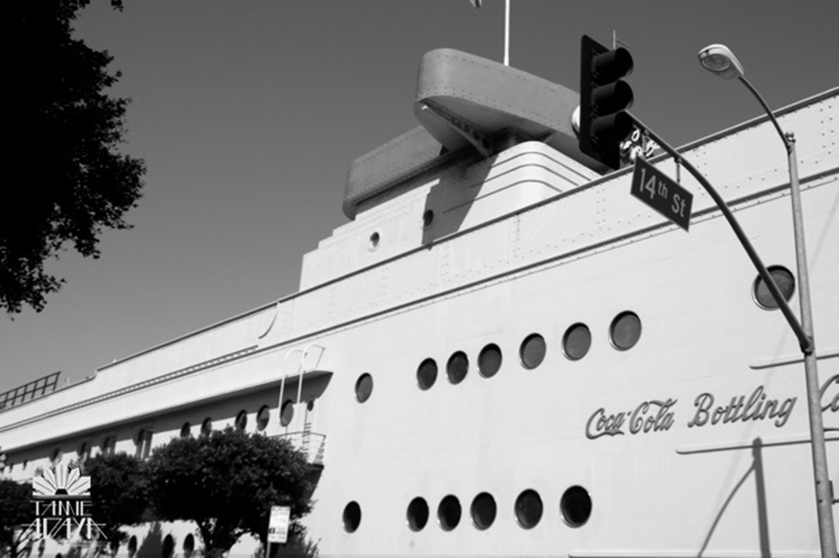
Historical Notes The Coca Cola Building is a Coca-Cola bottling plant modeled as a Streamline Moderne building designed by architect Robert V. Derrah with the appearance of a ship with portholes, catwalk and a bridge from five existing industrial buildings in 1939. |
 |
|
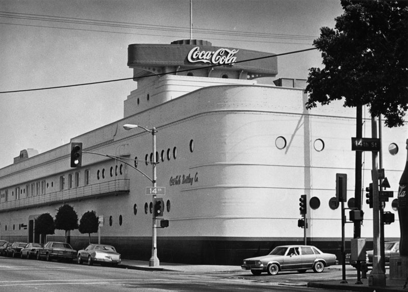
| (1982)* - View of the Coca-Cola Building, a legendary building on a legendary street, 1334 South Central Avenue, as it appeared in 1982. |
Historical Notes The Coca-Cola Building was designated Los Angeles Historic-Cultural Monument No. 138 in 1975 (Click HERE to see complete listing). |
 |
|
| (2010s)* - View showing the Coca-Cola Company Bottling Headquarters, looking more like a cruise ship, located on the northeast corner of Central Avenue and 14th Street. Click HERE for contemporary view. |
Historical Notes Robert V. Derrah’s Coca-Cola Company Bottling Headquarters is a stunning expression of Streamline Modern style, a later branch of the Art Deco movement, featuring curving forms, long horizontal lines, and nautical influence. |
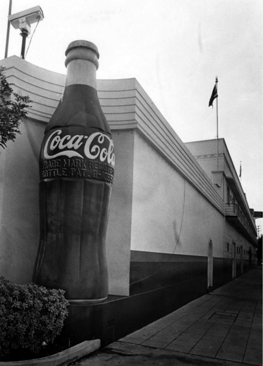 |
|
| (1982)* – Looking down the length of the Coca-Cola Building, located at 1334 S. Central Avnue in Los Angeles. |
Historical Notes The Los Angeles Historic-Cultural Monument was remodeled from five older warehouses into a Streamline style ocean liner by architect Robert V. Derrah in 1936. |
* * * * * |
Fleetwood Center
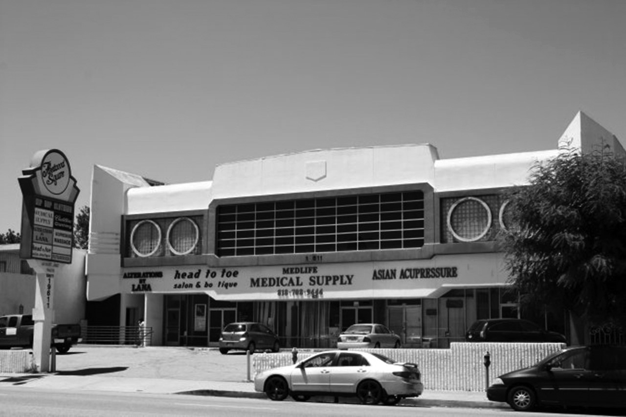 |
|
| (ca. 2010)* – View of the Fleetwood Plaza located at 19611 Ventura Boulevard in Tarzana. Photo by Jessica Hodgdon |
Historical Notes Constructed in 1987, according to An Architectural Guidebook to Los Angeles, it was designed in the Programmatic style of architecture, although it's unclear if a Cadillac dealership ever actually occupied the space. Lee Oakes of architectural firm Matlin and Dvoretzky designed the two-story building for developer CBS Realcorp. |
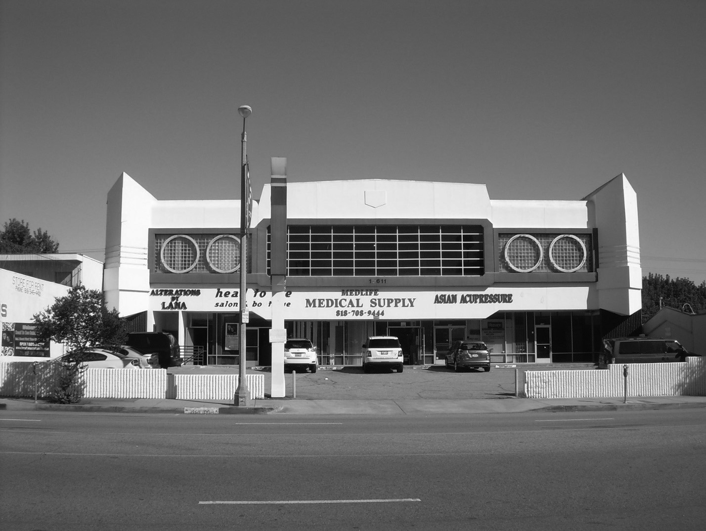 |
|
| (2015)* – View of the Fleetwood Square mini-mall on the north side Ventura Boulevard east of Corbin Avenue. It was designed to look like the front of a Cadillac Fleetwood. |
Historical Notes The building has angular corner turrets like the jutting front fenders of a ca. 1970 Caddy, punctuated by four “headlights” of circular neon, central windows arranged like a radiator grill, and first-floor masonry walls painted black to look like tires. It was designed expressly to draw attention to the block, and that it does, in a way that could not be more weirdly appropriate to its Ventura Boulevard setting. Tragically, the building's stucco finish is currently painted a subdued white, a far cry from its original shocking pink. |
* * * * * |
Binoculars Building (originally the Chiat/Day Building)
 |
|
| (2007)*^ - View showing the Binoculars Building which consists of three styles of architecture. Photo by Bobak Ha'Eri |
Historical Notes The Binoculars Building, originally the Chiat/Day Building, is a commercial building located in Venice which incorporates the public artwork "Giant Binoculars" by Claes Oldenburg and Coosje van Bruggen on its street-facing facade. Built between 1991 and 2001 for advertising agency Chiat/Day (now TBWA\Chiat\Day) as its West Coast corporate headquarters, it was designed by Los Angeles architect Frank Gehry, and was his last project in Los Angeles until the Walt Disney Concert Hall began construction in 1999. The Binoculars Building is notable for the three different styles used in the main facade on Main Street, particularly the massive "Giant Binoculars" sculpture covering both a car and pedestrian entrance. The entrance to the parking garage is between the lenses of the binoculars. |
 |
|
| (2014)* – Close-up view showing the entrance to the Binoculars Building in Venice, now occupied by Google. |
Historical Notes In January 2011, W. P. Carey & Co. announced Google was leasing 100,000 square feet of space in the building and two neighboring buildings, part of a major expansion to establish a larger employment presence in Los Angeles. |
* * * * * |
More Historical Early Views
Newest Additions
Early LA Buildings and City Views
History of Water and Electricity in Los Angeles
* * * * * |
References and Credits
* LA Public Library Image Archive
^*Facebook: SoCal Historic Architecture
*+*Los Angeles Planning Department: Idle Hour Café
+^^Facebook.com: Garden of Allah Novels – Martin Turnbull
^++Pinterest.com: California Dreamin
^*^ Nuestra Señora la Reina de los Ángeles: losangelespast.com
*^^Mordmardok.tumblr.com: The Big Cone
^**KCET: The Oil Can Restaurant
***Daily News
*^*Main Street Gazette - World Famous Photo Finishing
*^#Los Angeles Magazine: The Fish Shanty; Studio City Hand Car Wash
#^#Huffington Post: Los Angeles: Art Deco Mecca
^#^Los Angeles Conservancy: The Tamale; Fleetwood Center; Randy's Donuts
^*#Noirish Los Angeles: Bob's Airmail Service Station
*##MartinTurnbull.com: Freezer Ice Cream Store
^##Restaurant-ing Through History: Ice Cream Parlors
##*Mr. Cecil's California Ribs
^*^#Facebook.com - Bizzare Los Angeles
^^^*San Fernando Valley Relics: Facebook.com
^^#*Huntington Digital Library Archive
#*#^Flickr.com: Wilshire Boulevard History
#^#^Weird California: Los Angeles' Programmatic Architecture
#^*^Facebook.com: West San Fernando Valley Then And Now
***^Pomona Public Library Digital Archive: Bob's Airmail Service Station
*^ Wikipedia: Tail o' the Pup; Chili Bowl Restaurant - Art Whizin; Brown Derby Restaurant; Big Donut Drive-in; Randy's Donuts
< Back
Menu
- Home
- Mission
- Museum
- Major Efforts
- Recent Newsletters
- Historical Op Ed Pieces
- Board Officers and Directors
- Mulholland/McCarthy Service Awards
- Positions on Owens Valley and the City of Los Angeles Issues
- Legislative Positions on
Water Issues
- Legislative Positions on
Energy Issues
- Membership
- Contact Us
- Search Index