Early Views of Hollywood (1850 - 1920)
Historical Photos of Early Hollywood |
 |
|
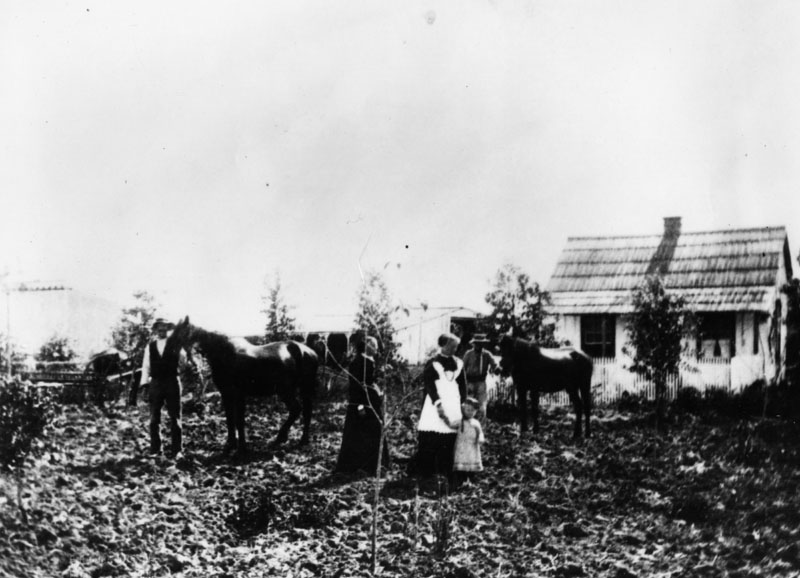
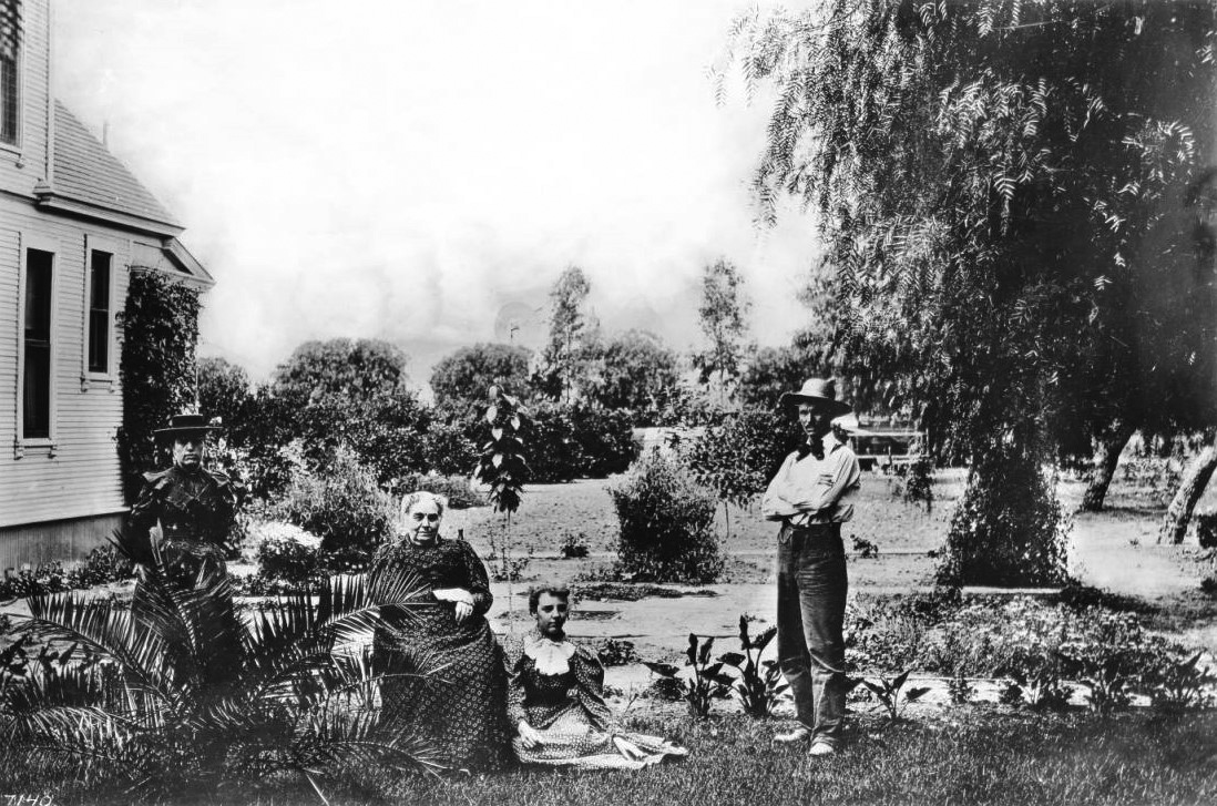
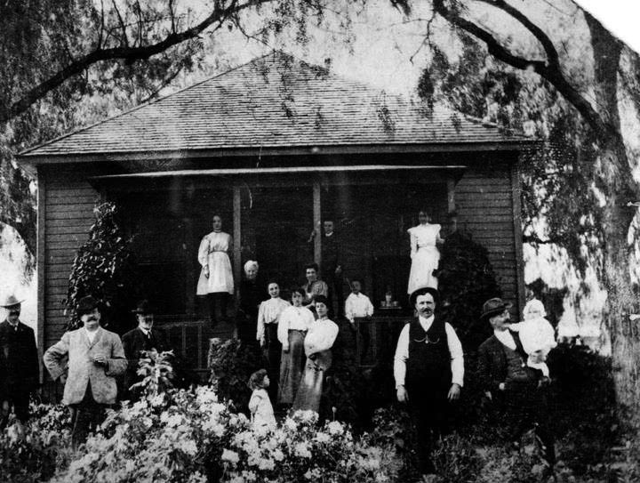
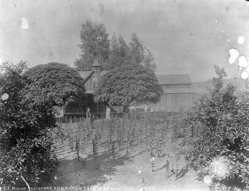
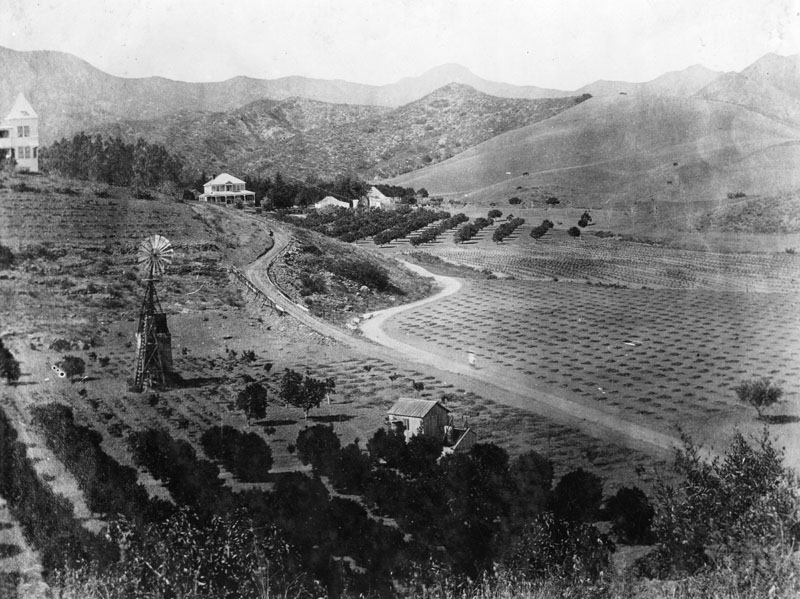
| (1860)* - View of the Duin residence, a small ranch house at Western and Lemon Grove Avenues in Hollywood. Two women and a child as well as two men with their horses pose for the camera at the ranch. |
Historical Notes In 1853, one adobe hut stood in Nopalera named for the Mexican Nopal cactus indigenous to the area. By 1870, an agricultural community flourished in the area with thriving crops of many common and exotic varieties. The area was known to these residents as the Cahuenga Valley, after the pass in the Santa Monica Mountains immediately to the north (Cahuenga is the Spanish name for the Tongva village of Kawengna, meaning place of the mountain). Soon thereafter, land speculation led to subdivision of the large plots and an influx of homeowners. |
 |
|
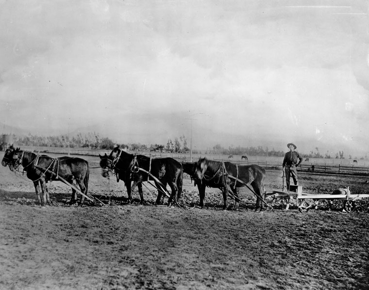
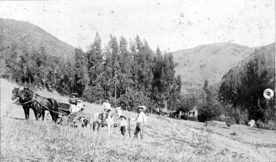
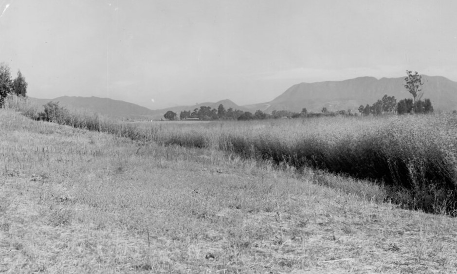
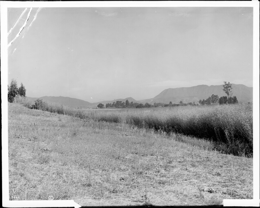
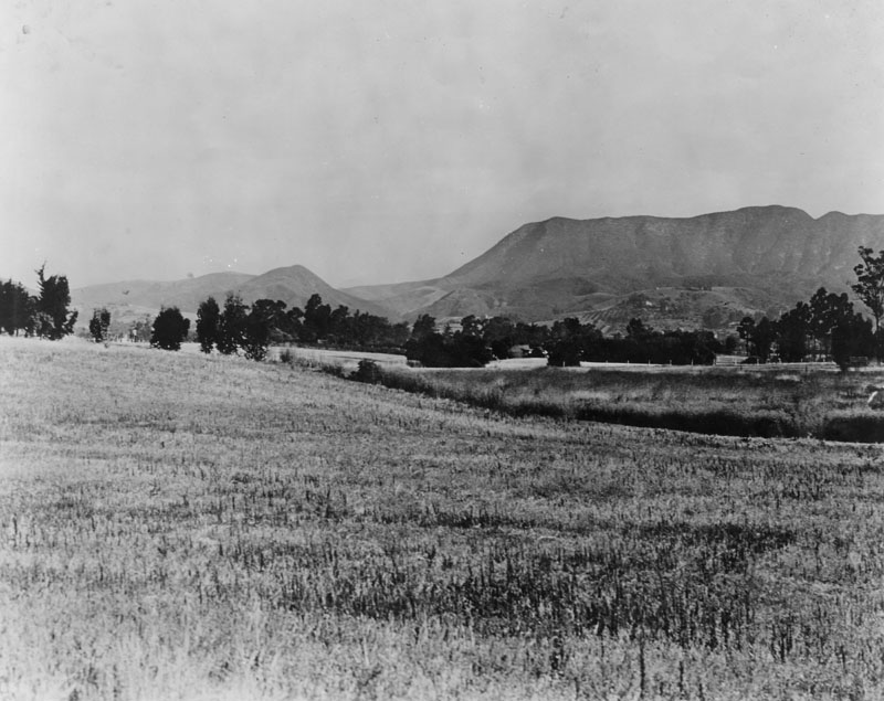
| (ca. 1874)* - Farmer Dennis Sullivan cultivates land near present-day Vermont Avenue, where Los Angeles City College now stands. The site was also home to UCLA before the university relocated to Westwood. View is looking north toward the Hollywood Hills. |
Historical Notes Today, Vermont Avenue effectively marks the eastern end of Hollywood. It starts in Griffith Park at the Greek Theatre in the Los Feliz neighborhood as a one-lane divided road (it is known as Vermont Canyon Road north of this point) and at the intersection with Los Feliz Boulevard, it widens to a two-lane road. Vermont Avenue passes to the east of the Barnsdall Art Park at the intersection with Hollywood Boulevard and the Children's Hospital of Los Angeles at Sunset Boulevard. |
 |
|
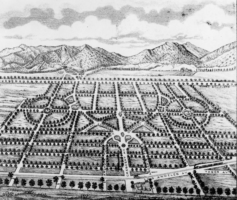
| (1877)* - "Birdseye view" drawing of an 1877 land promotional plan for a community to be known as Cahuenga, "the model suburb of Los Angeles, eight miles from the city, eight miles from the sea." Its northernmost street is Sunset Boulevard. |
Historical Notes The new community of Cahuenga was never built as shown above, with circular streets, etc., but some of its street names were later used elsewhere in the Hollywood area. |
 |
|
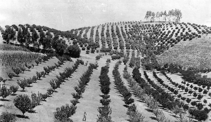
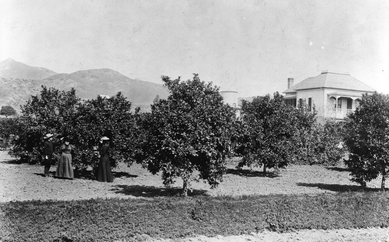
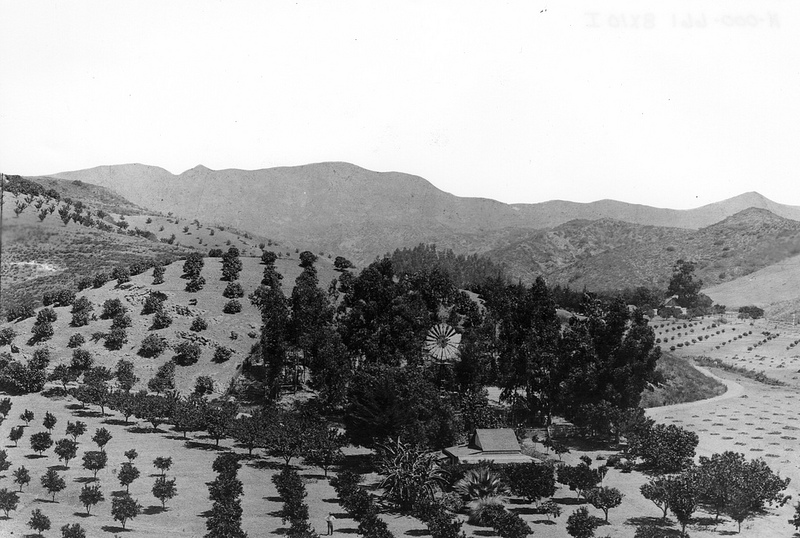
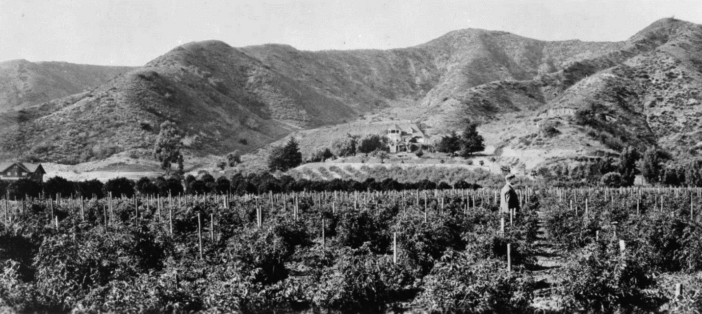
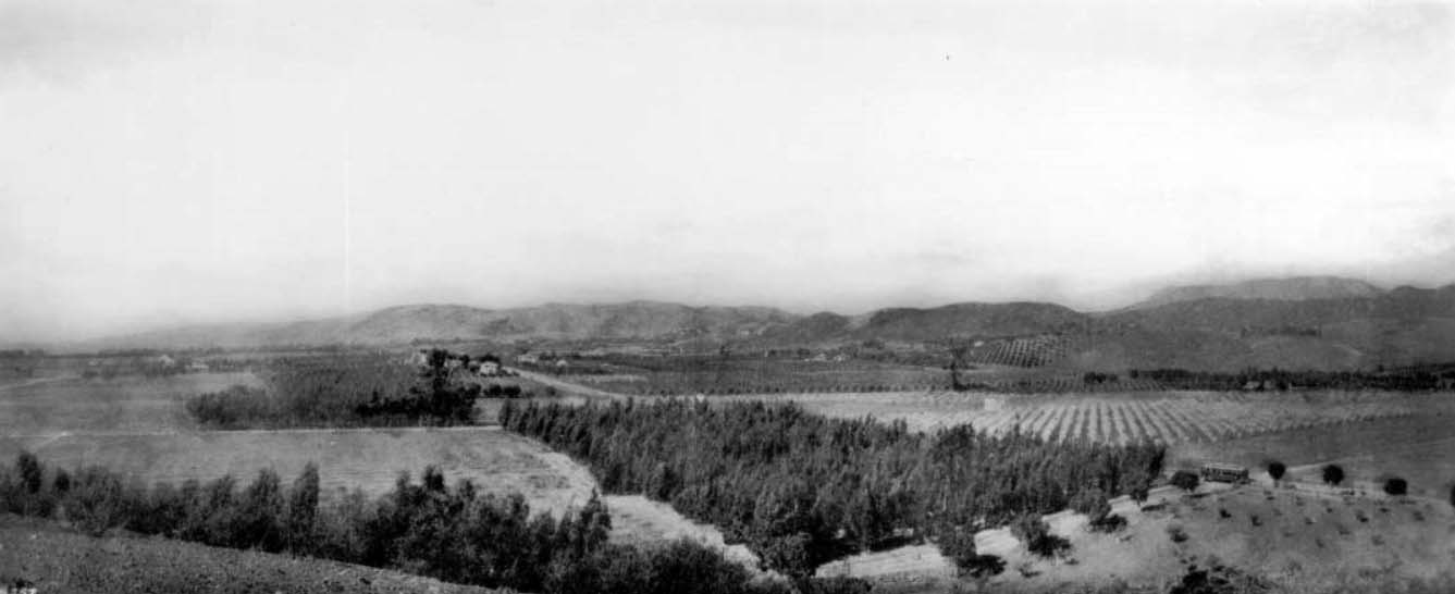
| (1880)* - View of the many orange trees that line the hills (later Krotona Hill), located near Gower and Beachwood Drive, in Hollywood. A man can be seen standing in the orange groves. |
Historical Notes In 1911, the Theosophical Society of Krotona established a colony on the above land located just north of the J.B. Rapp farm. The hill began to be known as Krotona Hill. |
 |
|
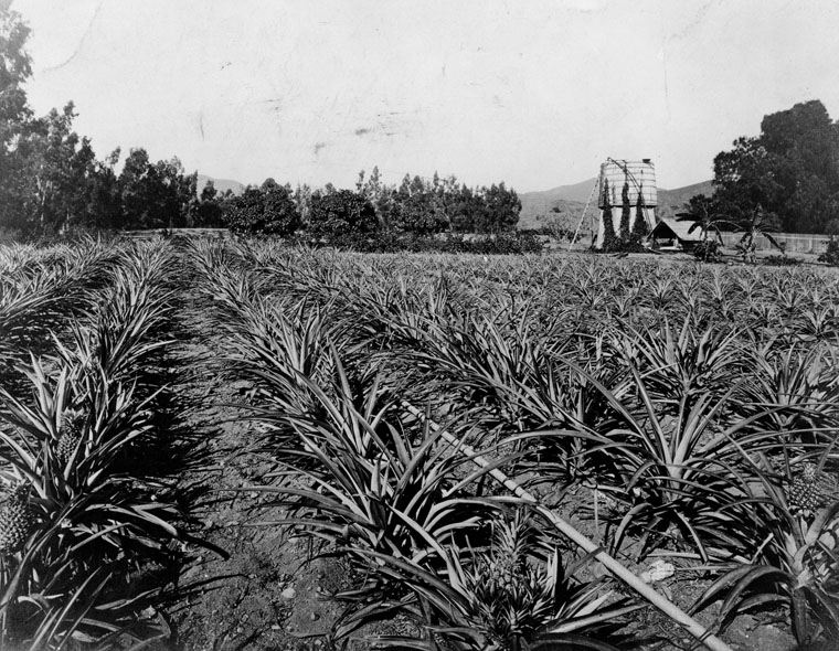
| (ca. 1880)* - View of J. B. Rapp's pineapple orchard located at Franklin and Beachwood, in Hollywood. |
Historical Notes J.B. Rapp began as a lemon grower but expanded into more exotic fruits–dates, avocados and pineapples, among others. Although it is likely that these fruits had their origins on local ranchos, Rapp was among the first to grow them commercially. At a time when oranges and lemons were rare delicacies for most Americans, pineapples and avocados must have caused a sensation. Hollywood’s frost-free climate made the cultivation of these crops possible. |
* * * * * |
Cahuenga Pass
 |
|
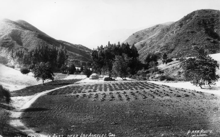
| (1882)* - Before roads and rail lines were built traveling through the Cahuenga Pass was by wagons and horses or on foot. This picture was taken at the summit. There is a saloon concealed among the trees. |
Historical Notes The Cahuenga Pass connects the Los Angeles Basin to the San Fernando Valley and is the lowest pass through the mountains. |
.jpg) |
|
| (1882)* - View of the summit of Cahuenga Pass with a saloon, Cahuenga Tavern, situated between the tall eucalyptus trees. |
Historical Notes Cahuenga is the Spanish name for the Tongva village of Kawengna, meaning place of the mountain. |
 |
|
| (n.d.)* - View of Cahuenga Tavern, also known as Eight Mile House, situated between eucalyptus near the summit of Cahuenga Pass. |
Historical Notes In the 1870s, a primitive hotel -- named the Eight Mile House because Los Angeles was eight miles down the road -- rose among a stand of eucalyptus trees inside the canyon. |
 |
|
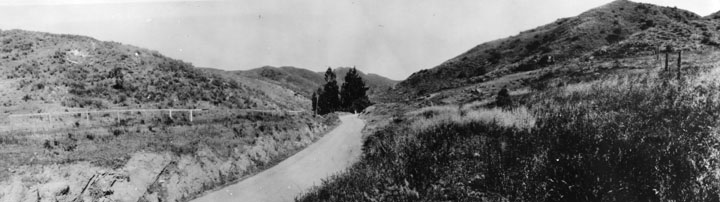
| (n.d.)* - View of early Cahuenga Pass. The road runs around and through a cultivated area. Click HERE to see more Early Views of Cahuenga Pass |
Historical Notes As late as 1914, filmmaker Cecil B. DeMille rented a wooden cabin in the pass as his home. He rode daily into his studio on horseback -- with a revolver on his hip. |
* * * * * |
Six Mile House (Sunset and Gower)
 |
|
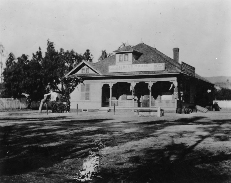
| (ca. 1885)* - Exterior view of Six Mile House, a bar offering wines and liquors, located on Sunset Blvd. at Gower Street in the 1880s. Just six miles from Los Angeles, it was a stopping point for 20-mule teams coming out Sunset Blvd. into the San Fernando Valley. |
Historical Notes Sunset Boulevard was dedicated in 1888. Earlier called Bellevue Street--and with some small sections called Short, Bread and Marchessault streets (after Mayor Damien Marchessault)--it started on U.S. Sen. Cornelius Cole's hill in what is now Hollywood, which afforded a fine view of the sunset over the Pacific. By 1937, 11 streets in Hollywood were named after the Cole family. Gower Avenue was dedicated in 1893. Named because it ran along the west side of the ranch belonging to George T. Gower. California's first films were made on the corner of Gower and Sunset Boulevard in 1911. |
 |
|
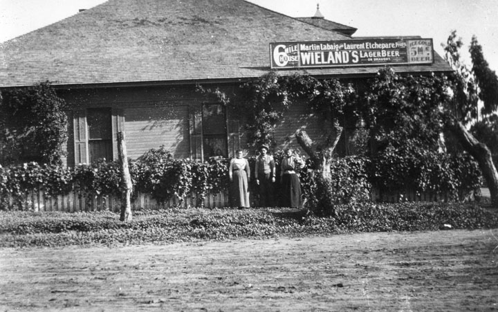
| (Early 1900s)* - Two women and a man pose at the side exterior of the Six Mile House Hotel. A sign on the roof reads "Martin Labaig and Laurent Etchepare, proprietors", and ice cold beer is advertised at 5 cents a pop. |
Historical Notes The description above comes from the LAPL image libarary. Gregory Paul Williams in his book The Story of Hollywood states that this business’ actual name was La Baig’s Casa Cahuenga (commonly referred to as the Six-Mile House). It was on the northeast corner of Sunset and Gower. Frenchman Martin La Baig convinced Harvey Wilcox to sell his French friends The Blondeaus 5 acres across Gower Ave from him. The Blondeaus built their home there in 1887, and in 1889 they built an additional to turn it into The Blondeau Tavernl. |
 |
|
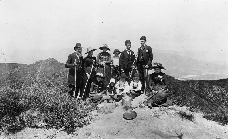
| (ca. 1885)* - A group of people is seen on Mount Hollywood, having climbed it. Some are holding walking sticks, and one man holds a gun. Three children are seated on the ground, with two women. Metal buckets and a pan are also on the ground. In the background, a river flows on the flat land below. The people are formally dressed, as was the custom at the time. |
* * * * * |
Cahuenga Valley Township School
 |
|
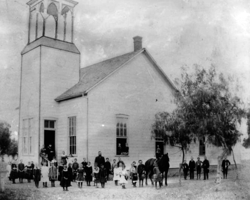
| (ca. 1884)* - Group portrait of the students at Cahuenga Valley Township School posing in front of the school with a horse. The schoolhouse is a wooden building with a tall bell tower at left and a brick chimney at center. There are five wood-framed windows along the perimeter of the building, and an open doorway is visible at left. |
Historical Notes Cahuenga Valley Township School in 1884 had a limited student body and faculty. Some reports noted that the horse in the photo was used to bring students to and from school, just like the "big yellow buses" of today. |
 |
|
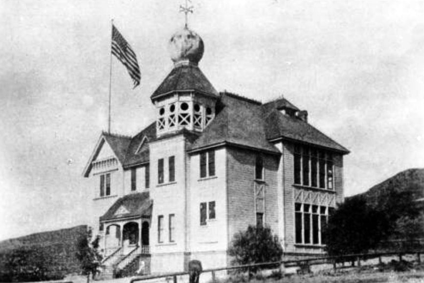
| (ca. 1887)* - Head of Vermont Avenue - Photograph of an exterior view of the old Los Feliz school in Cahuenga Valley, later Hollywood. The building is a two-story wood building with a large tower at center. The top level of the tower is an open deck, and the roof of the tower is onion-shaped. A tall flagpole stands on the roof at left and a large flag flies from it. The main entrance to the school is at left and consists of a stairway leading up to a covered porch. The windows of the school are tall and rectangular, and they are very close together at right. There is a hill in the background, and a low wooden fence is in the foreground. |
* * * * * |
Early Hollywood
 |
|
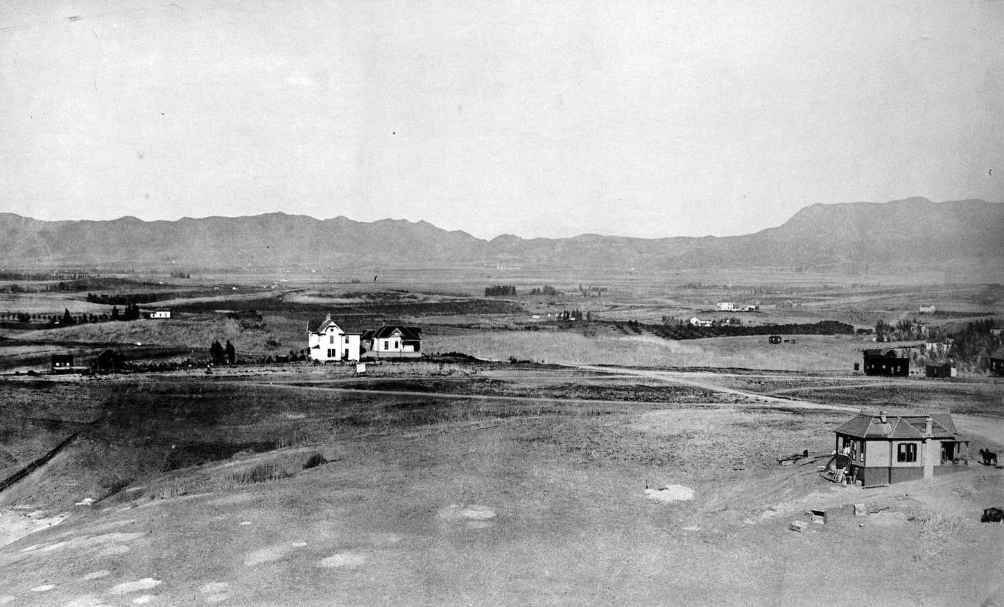
| (ca. 1886)* - View looking north from the Belmont Hotel on Crown Hill (where the old Belmont High School stands today) showing the Hollywood Hills in the background. Note the vast open space between downtown and the hills. |
 |
|
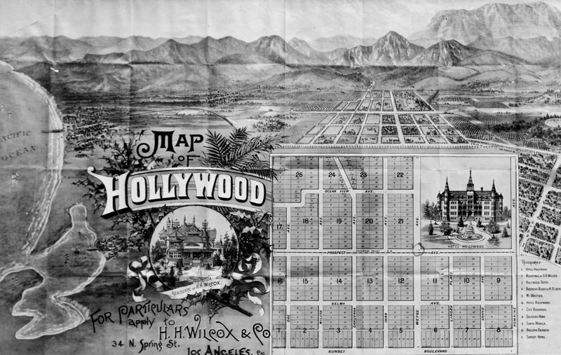
| (ca. 1887)* - Drawing of the first map of Hollywood, issued by real estate agent H.H. Wilcox in 1887. Tracts and lots are numbered on the map. The Hotel Hollywood inset never was built as shown. Wilcox' residence is another inset. His office was located at 34 North Spring Street, where people could inquire for particulars concerning the development. Various other sites are listed at right and numbered accordingly on the map. Railroad routes are also included. At left is the Pacific Ocean. |
Historical Notes Harvey Henderson Wilcox, the first subdivider of Hollywood, used as its name the suggestion made by his wife, Daeida. They had purchased 160 acres in 1886, which they subsequently subdivided and sold. (Prospect Avenue was the original name for Hollywood Blvd., and Weyse Avenue was the original name for Vine Street.) The name Hollywood was originally coined by H. J. Whitley, the "Father of Hollywood". Whitley arranged to buy the 500-acre E. C. Hurd ranch and disclosed to him his plans for the land. They agreed on a price and Hurd agreed to sell at a later date. Before Whitley got off the ground with Hollywood, plans for the new town had spread to General Harrison Gray Otis, Mr. Hurd's wife, Mrs. Daeida Wilcox, and numerous others through the mill of gossip and land speculation. A 2ND version about the naming of Hollywood: “Regarding H.J. Whitley’s coining the name, Whitley's great-granddaughter Gaelyn Whitney Keith invented this story out of whole cloth. (She wrote a "biography" of Whitley that reads like a romance novel.) Loads of old newspapers very clearly place H.J. Whitley in North Dakota throughout 1886-1887. He later moved to Oklahoma and didn't come to L.A. until 1894 – seven years after the Wilcoxes named Hollywood. So the whole story of Whitley trying to buy 500 acres from E.C. Hurd in 1886, then the Wilcoxes stealing the "Hollywood" name before Whitley could close the deal, is bunk, blarney, B.S. It's shameful that Ms. Keith has spread this lie around the internet, just to sell her book.” |
 |
|
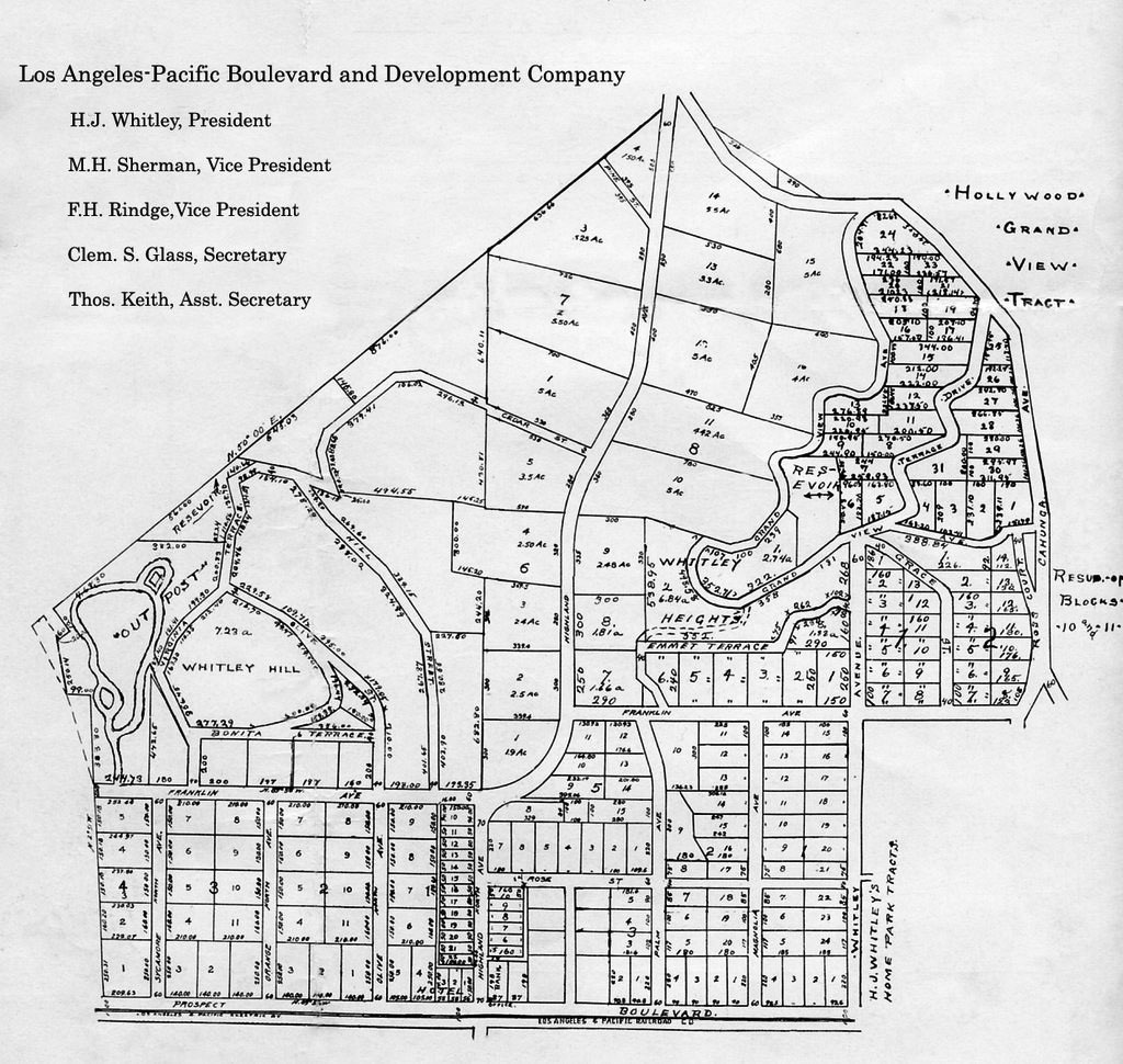
| (ca. 1880s)* - Original 480 acre map of H.J. Whitley's property developed by his company, Los Angeles Pacific Boulevard and Development Company. Highland Avenue runs through the center of the property. The square at the lower right hand corner is the Whitley Estate and was not part of the Grand View development. Courtesy of the Whitley Family |
Historical Notes In the mid-1880s, H.J. Whitley arrived in Southern California. He was well known as a land developer and many tried to follow on his coattails. As president and major shareholder of the Los Angeles Pacific Boulevard and Development Company, he orchestrated the building of the Hollywood Hotel, the opening of the Ocean View Tract and construction of a Bank which were located on the corners of Hollywood Boulevard and Highland. Besides his land developments, Whitley was also the President of the National Loan & Trust Company, Guthrie, Oklahoma, Vice President of Home Savings Bank, President of First National Bank of Van Nuys, State Bank of Owensmouth and Bank of Lankershim; General Manager of the Los Angeles Suburban Homes Company, principal in the Bank of Hollywood, The Whitley Land Company and owner of the H.J. Whitley Company jewelry store. |
 |
|
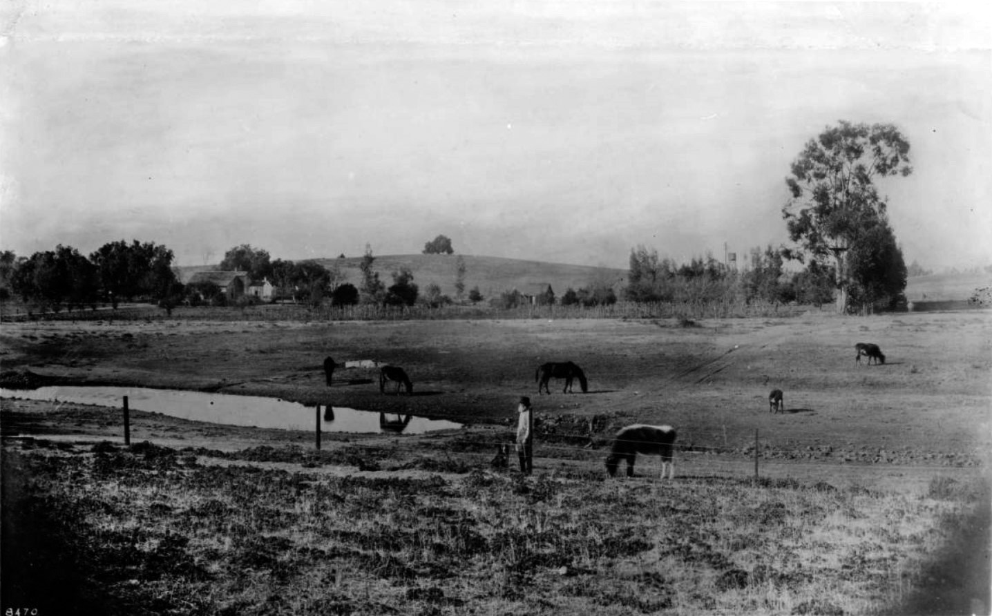
| (ca. 1894)* – View of the Ireby Barrow Ranch looking north. Boundaries of the ranch were: Beverly Boulevard (then Temple Street) on the south, Rosewood Avenue on the north, Vermont Avenue on the east, and Normandie on the west. Cahuenga Valley School (now Normandie) was just beyond the left house in the photograph. Horses and cattle graze near a pond. A bearded man and his dog stands next to the wire fence in the foreground. The man appears to be holding a rifle. |
Historical Notes The Barrow family moved from Illinois to California in 1880 and purchased land with boundaries of Beverly Boulevard on the south, Rosewood Avenue on the north, Vermont Avenue on the east and Normandie on the west. |
* * * * * |
Cahuenga Valley Railroad (1887)
 |
|
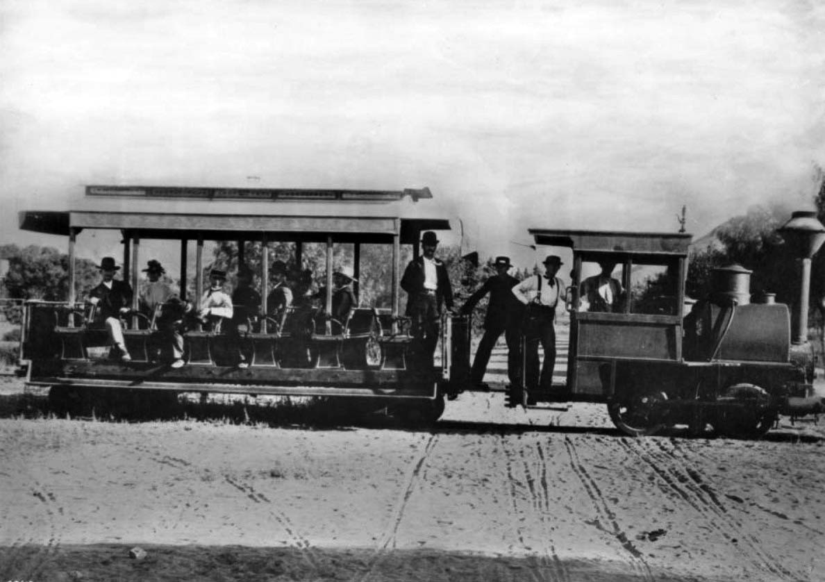
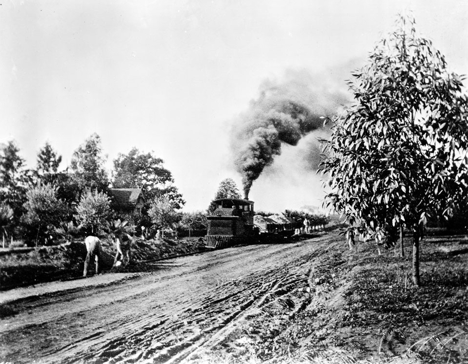
| (ca. 1888)* - Photograph of the first train on the Cahuenga Valley Railroad to Hollywood. A small steam engine and one passenger car are pictured. Seven people are visible in the passenger car, one in the engineer's quarters and three on the running board between cars. The terrain around the train is unpaved, yet has what appears to be wagon tracks marked into it, perpendicular to and intersecting the train tracks. Sparse vegetation is visible in the background, and at the extreme right background, the beginning of a mountain. Photograph is taken at Prospect Avenue (later Hollywood Boulevard) and Wilcox Avenue.* |
Historical Notes The beginnings of a railroad which would link Los Angeles with far off Cahuenga Valley occurred on January 11th, 1887 when James McLaughlin obtained a franchise to build a steam dummy line connecting to the 2nd Street Cable Railroad at Diamond (Beverly Boulevard) and Texas (Belmont Avenue) Streets. The line would extend north along Texas to Temple and then westward to the Los Angeles City Limits at Hoover Street and beyond. The Cahuenga Valley Railroad line utilized what was colloquially known as the "Dummy line," featuring cable cars with wooden chairs for passenger seating. This relatively modest transportation system nonetheless played a transformative role in opening the Cahuenga Valley to development and connecting it with the expanding city of Los Angeles. |
 |
|
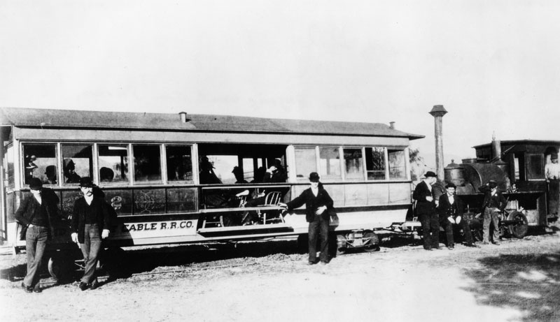
| (ca. 1890)^ - In this photo the Cahuenga Valley Railroad line cable car is also called the "Dummy line." Note the inside of the cable car is actually hollow with wooden chairs being used for sitting. |
Historical Notes The diminutive steam train would begin its journey to Cahuenga Valley from Diamond (Beverly Boulevard) and Texas (Belmont Avenue). Leaving the city limits, the little train wandered west across open fields eventually finding County Road where it turned north. County Road later became Western Avenue. Next stop, Coleville or Coles Crossing (later, Santa Monica Boulevard). At this point, the Cahuenga Valley line crossed the steam dummy line to Santa Monica. The train continued north to Prospect Avenue (Hollywood Boulevard) where the line turned west. That was called Grand Round. Today we know it as Hollywood and Western. Next stop, Midway (later called Bronson Avenue). The end of the line was at Prospect Avenue (Hollywood) and Wilcox. It was here that McLaughlin built himself a rather imposing “McMansion” on the northwest corner of that intersection. |
 |
|
| (ca. 1890s)* - The Cahuenga Valley Railroad, a steam railroad built in the 1880's to provide access to Hollywood. The locomotive and passenger car is shown on Hollywood Boulevard, then Prospect Avenue. |
Historical Notes Hollywood Boulevard was named Prospect Avenue from 1887 until 1910, when the town of Hollywood was annexed by the City of Los Angeles. After annexation, the street numbers changed from 100 Prospect Avenue, at Vermont Avenue, to 6400 Hollywood Boulevard. |
 |
|
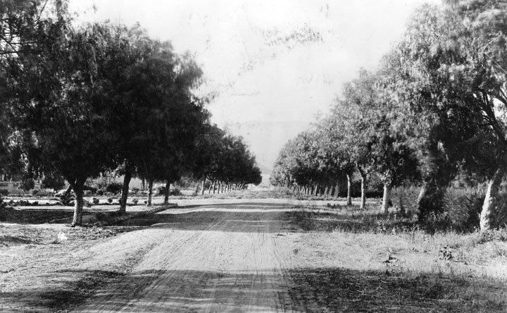
| (ca. 1890)* - Wilcox Ave. from south of Prospect Ave. (later Hollywood Blvd.) as an unpaved, tree-lined road. |
* * * * * |
Cahuenga Valley Railroad (1890s)
 |
|
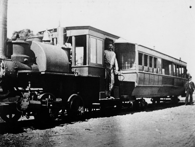
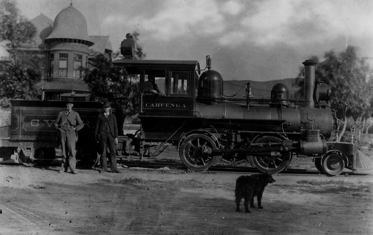
| (ca. 1893) – View of the Cahuenga Valley Railroad’s third and final locomotive, Cahuenga, shortly after its delivery from Porter Locomotive Works. The camera is facing north along Wilcox Avenue, with the locomotive resting on Prospect Avenue (now Hollywood Boulevard). At left stands the Queen Anne–style mansion of James McLaughlin, owner of the railroad. The house was later sold to E.C. Hurd, and then to Hobart J. Whitley, the influential developer of Whitley Heights and a charter member of Los Angeles' early business elite. One of the men standing beside the engine—most likely the one in the dark suit and hat—is believed to be James McLaughlin himself, captured here during a key moment in the brief but formative era of rail transit in early Hollywood. |
Historical Notes The Cahuenga Valley Railroad was established in the late 1880s, originally running from Diamond Street (now Beverly Boulevard) and Texas Street (now Belmont Avenue) westward to the city limits at Hoover Street, then continuing along County Road (later renamed Western Avenue). From there, the line extended north to Prospect Avenue (now Hollywood Boulevard) and west to Wilcox Avenue, where it terminated around 1888. In 1890, the railroad was sold to E.C. Hurd and S.E. Mattison, who extended the line west along Prospect Avenue to Laurel Canyon, helping open the surrounding area to residential development. At the same time, James McLaughlin—builder of both the railroad and one of Hollywood’s earliest grand homes—sold his elegant Victorian mansion at the northwest corner of Prospect and Wilcox to E.C. Hurd. The sale of both the railroad and the residence marked a transition point in Hollywood’s history, as large parcels of land began to give way to subdivision and suburban expansion. |
 |
|
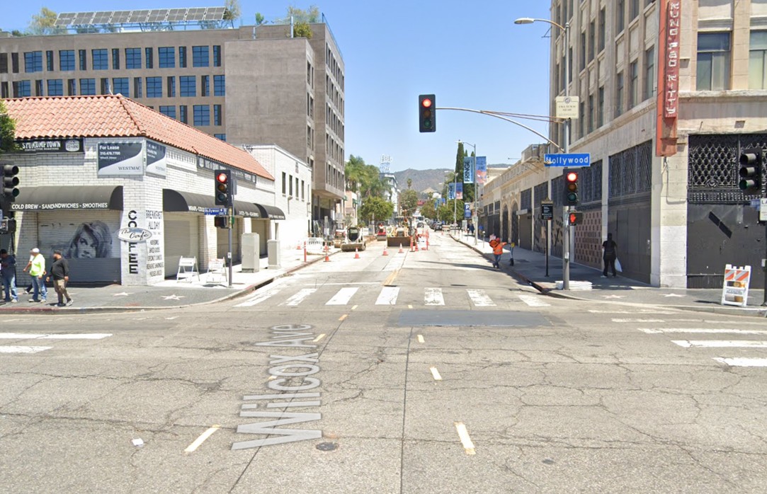
| (2024)* - Looking north on Wilcox Avenue at Hollywood Boulevard. |
Historical Notes Today, the intersection of Hollywood Boulevard and Wilcox Avenue is part of a global entertainment district known for its tourist appeal. It contrasts sharply with its modest beginnings as an agricultural stopover—and just as sharply with the glamorous peak of Hollywood’s Golden Age. Though still iconic, the area bears little resemblance to the elegance and charm it once radiated. |
Then and Now
 |
|
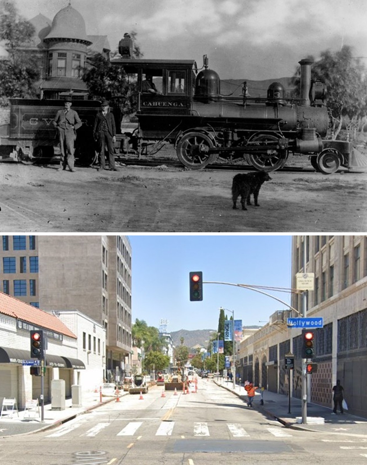
| (1893 vs. 2024)* - A 'Then and Now' comparison of Wilcox Avenue looking north from Hollywood Boulevard (originally Prospect Avenue). |
Historical Notes In 1893, the intersection of Hollywood Boulevard (then known as Prospect Avenue) and Wilcox Avenue was a quiet, rural crossroads surrounded by orchards, open fields, and minimal development. Though Harvey Wilcox had subdivided the land a few years earlier, settlement remained sparse, with few structures and limited infrastructure. Transportation was provided by the Cahuenga Valley Railroad, which extended west along Prospect Avenue and terminated at Wilcox, helping spur the area’s early growth. Today, the same intersection is a bustling urban hub and part of the world-famous Hollywood Walk of Fame. The area features dense mixed-use development, historic buildings like the Attie Building, and is supported by modern public transit including nearby Metro stations. Yet despite its fame and constant foot traffic, the intersection no longer reflects the elegance and charm of Hollywood’s Golden Age. Touristy and often overcrowded, the area is a far cry from both its pastoral beginnings and its cinematic heyday. |
 |
|
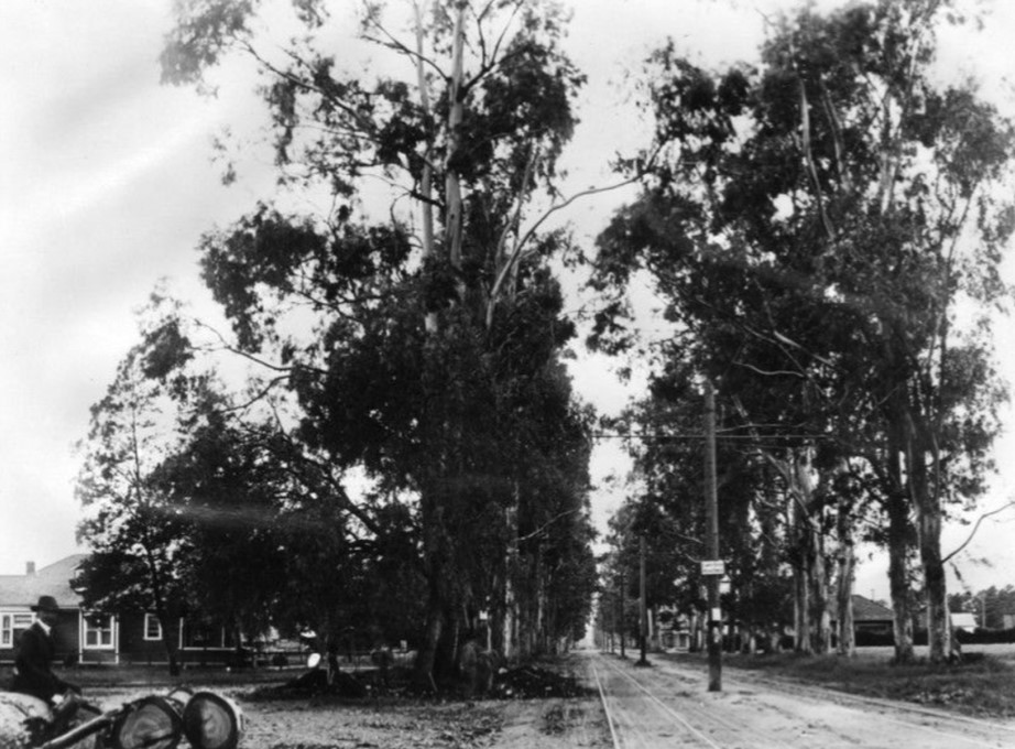
| (ca. 1898)* - View of workers grading the roadbed and installing streetcar tracks on Hollywood Boulevard. |
Historical Notes In 1890, E.C. Hurd and S.E. Mattison purchased the Cahuenga Valley Railroad from its original builder, James McLaughlin, and extended the narrow-gauge line west along Prospect Avenue (now Hollywood Boulevard) to Laurel Canyon, encouraging residential growth in the area. In May 1896, Hurd and Mattison sold the line to Moses Sherman and Eli P. Clark, operators of the Los Angeles Pacific Railway. The line was later incorporated into Henry Huntington’s expanding Pacific Electric system, which helped further transform Hollywood from a rural outpost into a connected suburban community. |
 |
|
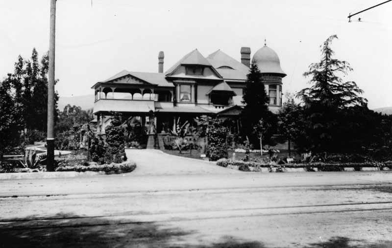
| (ca. 1900)* - Exterior front view of the two-story Victorian Hollywood residence of H.J. Whitley who purchased it from E. C. Hurd one year earlier. Hurd was a member of the Cahuenga Valley Water Company in Hollywood. The beautiful mansion on the northwest corner of Pospect (later Hollywood) and Wilcox was originally built by James McLaughlin who also built the Cahuenga Valley RR. |
Historical Notes E. C. Hurd made his fortune from the mines of Colorado and invested it in a prime Hollywood tract. In May 1896, Hurd and Mattison sold the railroad line to Moses Sherman and Eli P. Clark, operators of the Los Angeles Pacific Railway. The line was later incorporated into Henry Huntington’s expanding Pacific Electric system, which helped further transform Hollywood from a rural outpost into a connected suburban community. |
 |
|
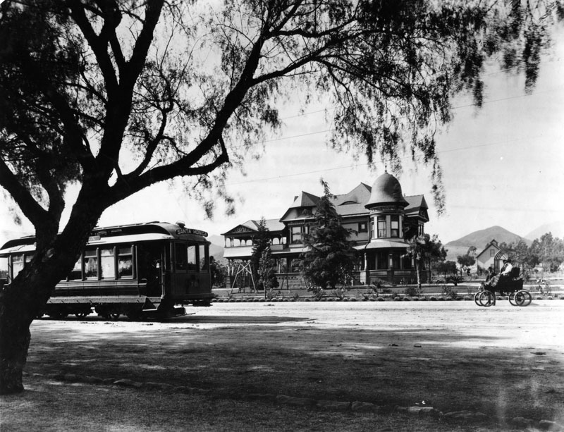
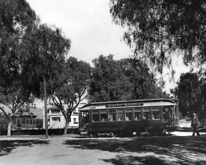
| (1900)* - Exterior front view of the Victorian style H.J. Whitley residence (previously the Hurd Residence) at 6594 Hollywood Blvd. at Wilcox Avenue. A streetcar, labeled Santa Monica, is on the street in front of the house. Also a couple are sitting in an open-air automobile, and the woman wears a lap robe. |
Historical Notes In 1899 the Hurd home was bought by farmer and banker H.J. Whitley, a director of the State Bank of Owensmouth. Known as the "Father of Hollywood," Whitley Heights is named for him. Streetcar service on Hollywood Boulevard began in the 1890s, initially provided by the Los Angeles Pacific Railway, a private electric railway company. This early service helped connect the then-rural community of Hollywood with growing neighborhoods to the east and south. Tracks were gradually extended westward along Prospect Avenue (renamed Hollywood Boulevard in 1910), reaching as far as Laurel Canyon by the turn of the century. On September 15, 1909, the Hollywood Line officially opened as part of the Los Angeles Pacific system, offering regular electric streetcar service between Downtown Los Angeles and Hollywood. In 1911, this system was absorbed into Henry Huntington’s Pacific Electric Railway, which expanded the service westward to Beverly Hills, West Los Angeles, and eventually the Santa Monica Bay. The introduction and expansion of electric streetcars on Hollywood Boulevard played a major role in transforming Hollywood from a quiet agricultural outpost into a thriving suburban and cultural center, drawing both residents and tourists and laying the groundwork for its future as a global entertainment capital. |
 |
|
| (ca. 1905)^ - View showing the northwest corner of Prospect (later Hollywood Blvd.) and Wilcox. In the foreground is a well-tended garden consisting of small pine trees, yucca trees, and patches of lawn. In the background at left, is the large Victorian mansion of banker H.J. Whitley. The two-story home consists of a covered balcony and cylindrical section with a rounded rooftop. In the extreme background at center, a group of large homes can also be seen. The Hollywood Hills stand in the background. |
Historical Notes Hollywood Boulevard was named Prospect Avenue from 1887 until 1910, when the town of Hollywood was annexed by the City of Los Angeles. After annexation, the street numbers changed from 100 Prospect Avenue, at Vermont Avenue, to 6400 Hollywood Boulevard. |
 |
|
| (ca. 1896)* - View showing the portrait of a family at their home on the southwest corner of Wilcox Avenue and Prospect Avenue (later Hollywood Boulevard). A man in a button-down shirt and a gardener's hat stands to the right on his family's lawn while three women sit and stand to the left of him. |
Historical Notes The following paragraph is taken from an article published in March 1937's Hollywood Magazine, entitled: "Hollywood Is Just a State of Mind." "As early-day residents or visitors trekked back to homes or inn, they always stopped at the front door, took down the inevitable feather duster that was hanging at the knob, and carefully dusted their shoes before they stepped over the sill! It was an old Hollywood custom - not to say an odd one. But very saving on carpets." |
 |
|
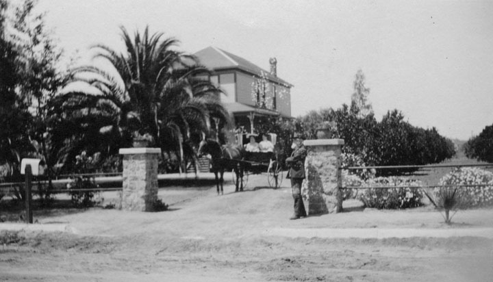
| (ca. 1895)* - A man stands near the entrance to his Hollywood property while two women ride in a horse-drawn carriage travel down the unpaved driveway to where is standing. A glimpse of a large orange grove is visible on the right. |
* * * * * |
Glen-Holly Hotel
 |
|
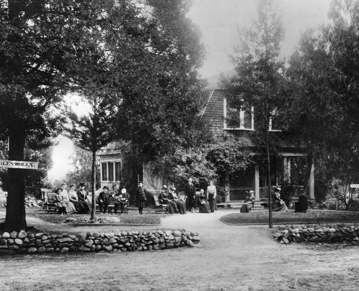
| (ca. 1895)* - People are seated in front of the Glen-Holly Hotel, at the corner of Ivar and Yucca Streets. The Hotel was run by C.M. Pierce and his wife (shown standing at right). |
Historical Notes The Glen-Holly Hotel was constructed in 1895 on Ivar Avenue at Yucca Street and is the 2nd hotel to be built in Hollywood (after the Sackett Hotel, 1888). It was built by Joakim Berg, a noted artist of the 1890s in the region. At its opening it had 20 rooms and one bath. A horse carriage called a tallyho took guests from downtown LA to the hotel. The original owner, Mr. Charles M. Pierce, also became the operator of the Los Angeles Pacific Railroad's Balloon Route in 1904, the line opened in September 1901. The hotel was a stop on the line going from downtown Los Angeles to West Los Angeles and the beaches on the west side. The Balloon Route used the hotel as lunch stop. D. L. Allen later took over management of the Glen-Holly Tavern. He added billiard hall, bowling alley, and livery service. It became a landmark of the area, though was later demolished. |
 |
|
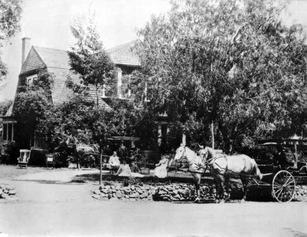
| (ca. 1900)* - View of the Glen-Holly Hotel on Ivar Street and Yucca Street in Hollywood. A carriage hooked to two horses stands with driver on the front yard of the two-story hotel behind it, which is mostly obscured by tree cover. A more personal horse-and-carriage stands closer to the main building, hooked to only one horse. On the lawn between the two carriages, four women sit, in chairs and on the ground, with a man standing behind them. Three out of the four of them are dressed in light clothing, while one of the women seated on chairs is dressed darkly. The man wears a dark suit and hat. Two empty rocking chairs sit in the driveway at left. The entrance to the hotel is demarcated by a short wall made of cobblestones, approximately a foot in height. The hotel building sports box windows on the second floor. |
* * * * * |
 |
|
| (ca. 1890)* – View showing the Bagnoli family in front of their home on an olive farm near what is now Sunset Boulevard and the Hollywood Freeway. |
Historical Notes The farm was started about 1890 and was located on Bagnoli Avenue (named after the family) which ran between Sunset and Carlton. By 1906 the family had returned to Firenze, Italy. The death of two sons in an accident made it impossible to maintain the farm. |
 |
|
| (ca. 1890)#^ - View of family members on a farm near Cahuenga Pass. On verso is written "Shoemaker Canyon." |
* * * * * |
Early Travel through Cahuenga Pass
 |
|
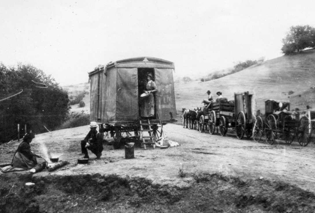
| (1892)* - Stopping to camp and cook along the journey through Cahuenga Pass. Before roads and rail lines were built, travel through the pass was by wagons and horses. |
Historical Notes During the 19th century, Cahuenga Pass saw significant development. By the 1850s, ox-carts and mule-teams were crossing the hills through the pass, and in 1858, the Butterfield Overland Mail Company stage made its first crossing. The 1870s brought the construction of the Pass Hotel, also known as Eight Mile House, which served as a toll station and store. |
 |
|
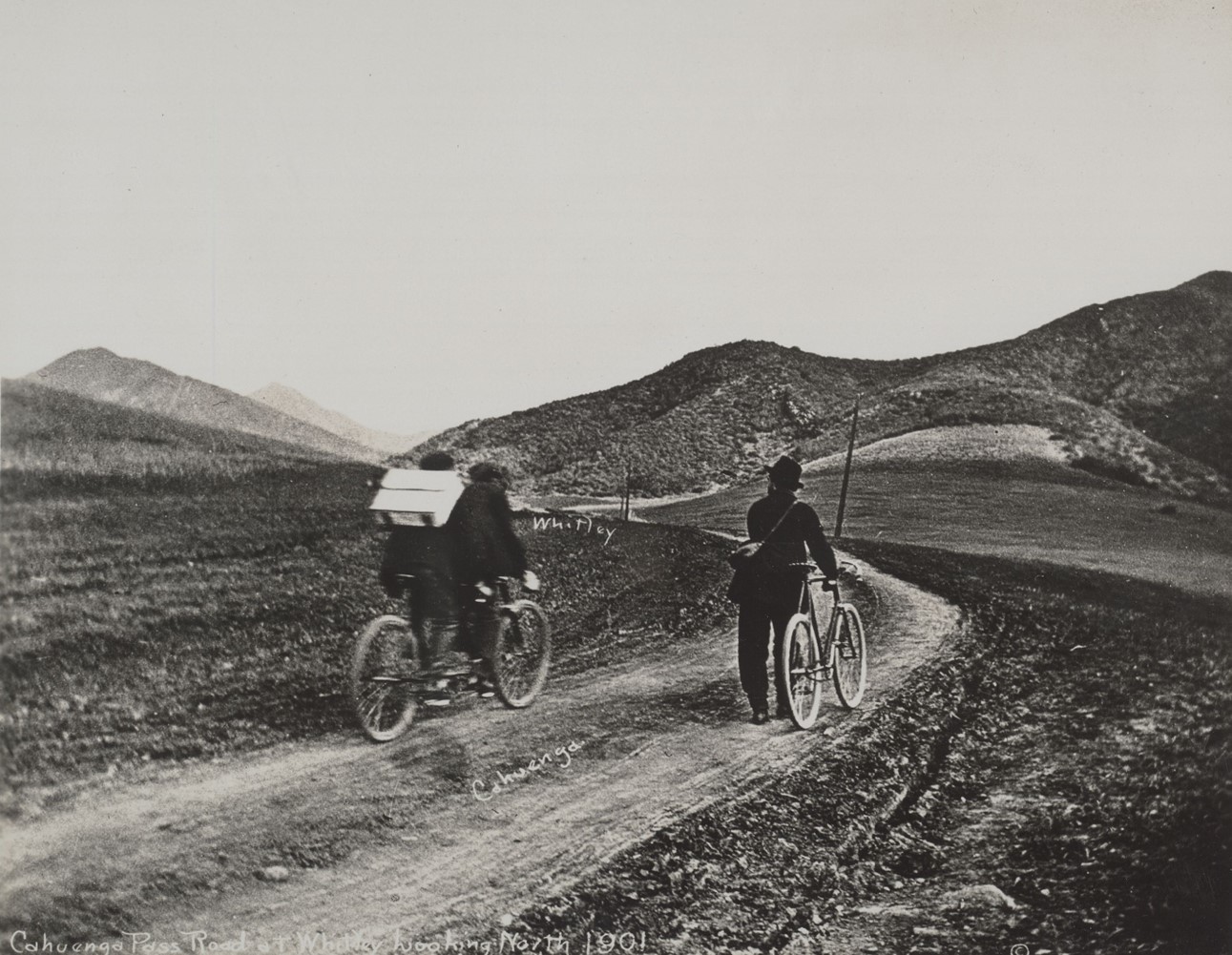
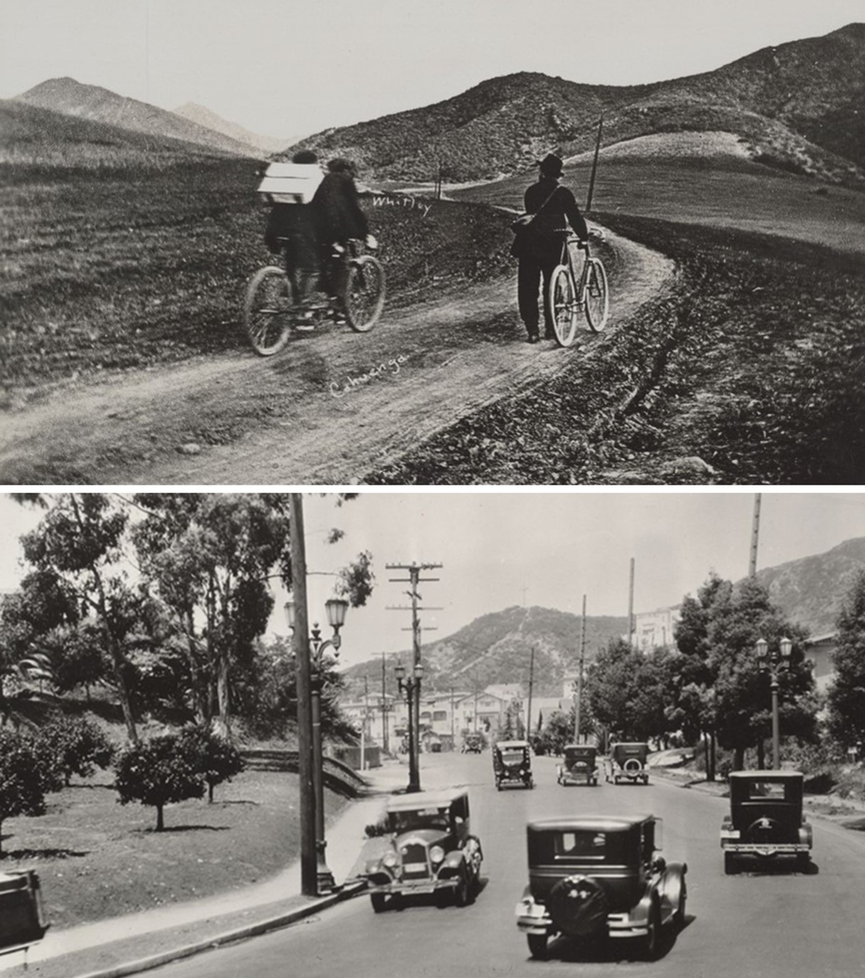
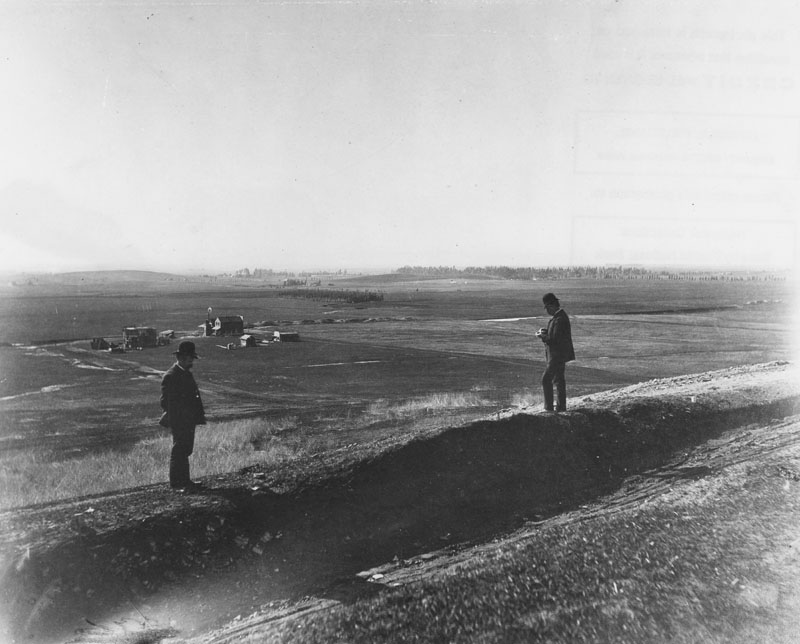
| (1901)* - Cahuenga Pass Road at Whitley looking northwest. Photo by C.C. Pierce |
Historical Notes Cycling through Cahuenga Pass around 1900 presented several challenges. The road was primarily designed for ox-carts, mule-teams making the terrain rough and uneven for cyclists. The road through the pass was continually widened to handle increasing traffic. In 1911, the Pacific Electric railway extended its tracks through the pass, and by 1920, traffic jams were common, prompting various improvement plans. |
 |
|
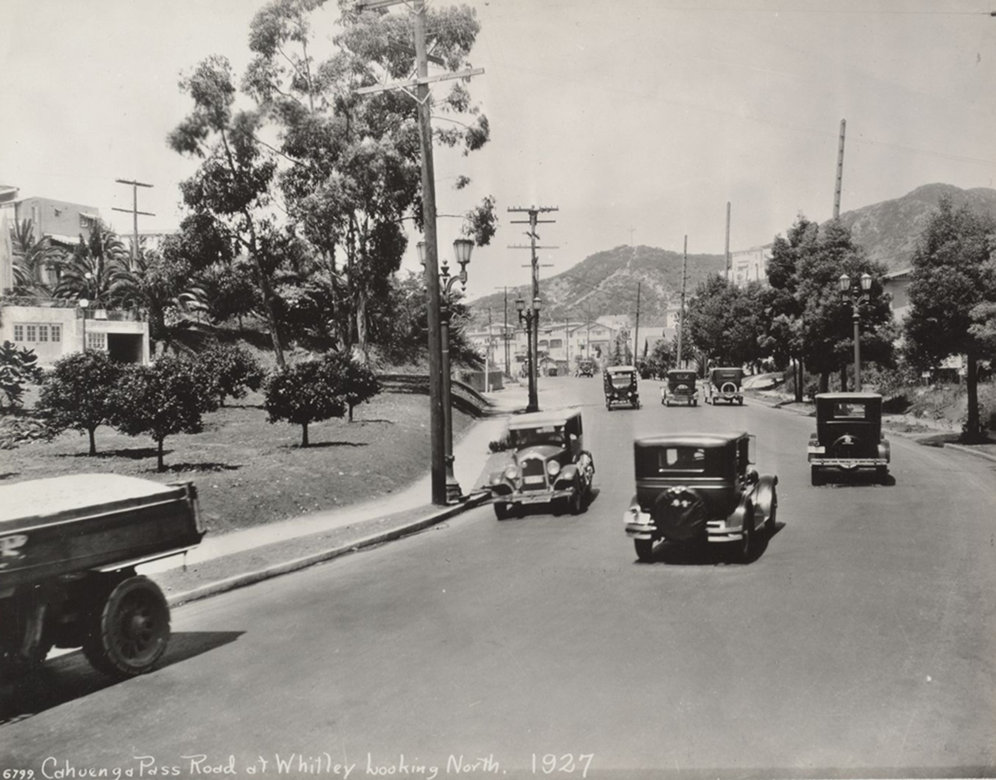
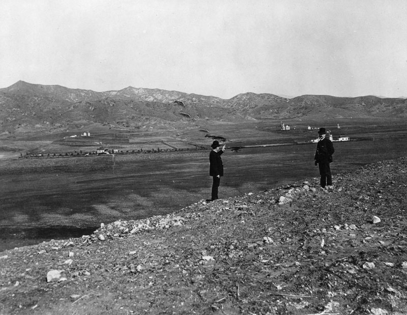
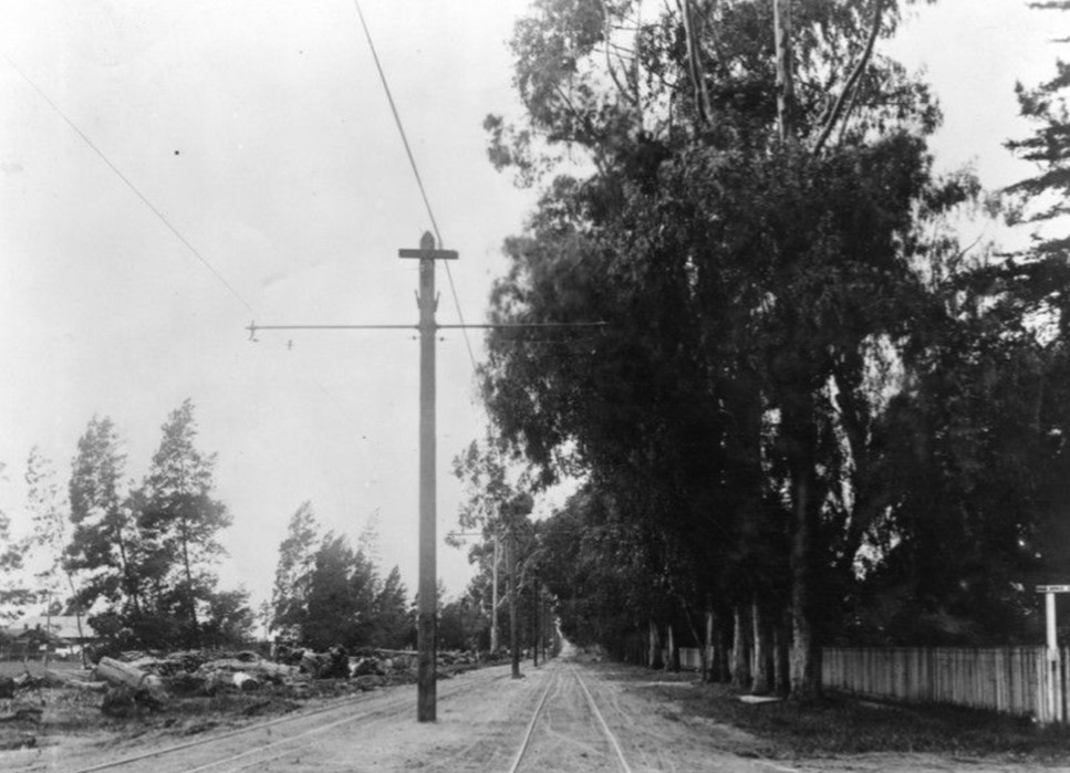
| (1927)* - Cahuenga Pass Road at Whitley looking northwest. Photo by C. C. Pierce. |
Historical Notes In 1925, the Los Angeles City Council passed Ordinance 51964, renaming Cahuenga Avenue to Cahuenga Boulevard. The ordinance justified the change by stating that Cahuenga was "a major highway, negotiating the historical Cahuenga Pass, which is the natural thoroughfare through the mountains from Hollywood to the San Fernando Valley." This renaming underscored the road's significance as a primary route connecting Hollywood to the San Fernando Valley, highlighting its essential role in the region's transportation network. |
 |
|
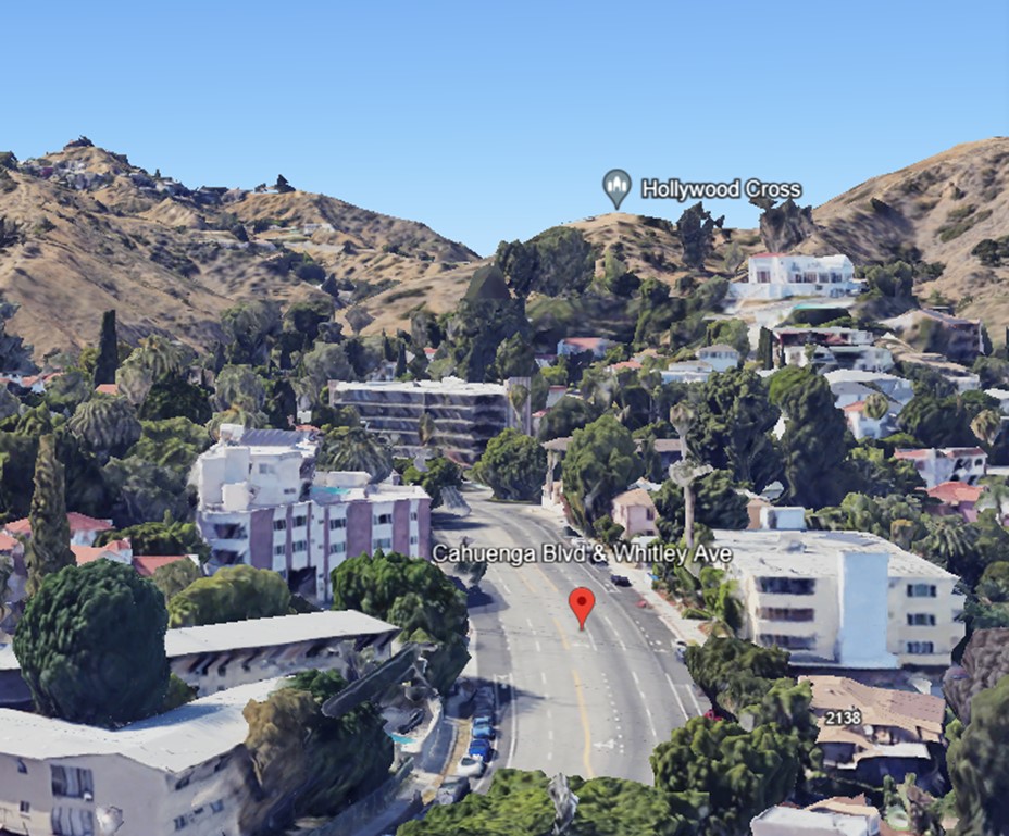
| (2022)* - Google Earth View looking northwest on Cahuenga Boulevard at Whitley Avenue. |
Before and After
 |
|
| (1901 vs. 1927)* – Looking northwest along Cahuenga Pass Road (now Cahuenga Boulevard) at Whitley in the Hollywood Hills. Over time, the road has been graded and lowered, but the ridgeline remains relatively unchanged. Photo comparison by Jack Feldman. |
Historical Notes Cahuenga Boulevard, originally known as Cahuenga Pass Road, has undergone significant transformations since its early days as a footpath through the Cahuenga Pass. In 1925, it was officially renamed from Cahuenga Avenue to Cahuenga Boulevard, reflecting its importance as a major thoroughfare connecting Hollywood to the San Fernando Valley. This change was part of a broader initiative to address growing traffic concerns in the rapidly expanding Hollywood area. |
Then and Now
 |
|
| (1901 vs. 2022)* - Looking northwest on Cahuenga Pass Road (now Cahuenga Boulevard) at Whitley in the Hollywood Hills. While the angles of the images differ and the road has been graded and lowered over time, the outline of the ridges has remained relatively unchanged. Photo comparison by Jack Feldman. |
Historical Notes Click HERE to see more Early Views of Cahuenga Pass. |
* * * * * |
Cahuenga Pass School
 |
|
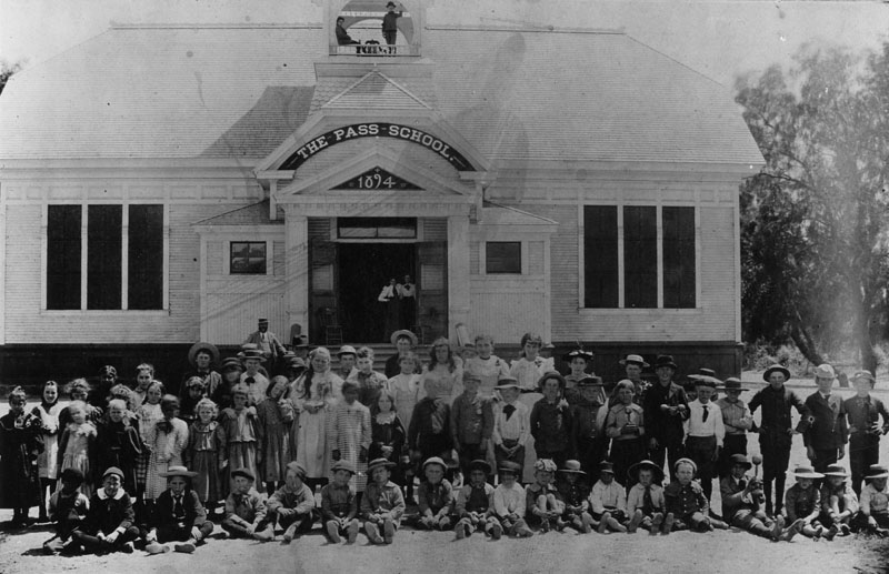
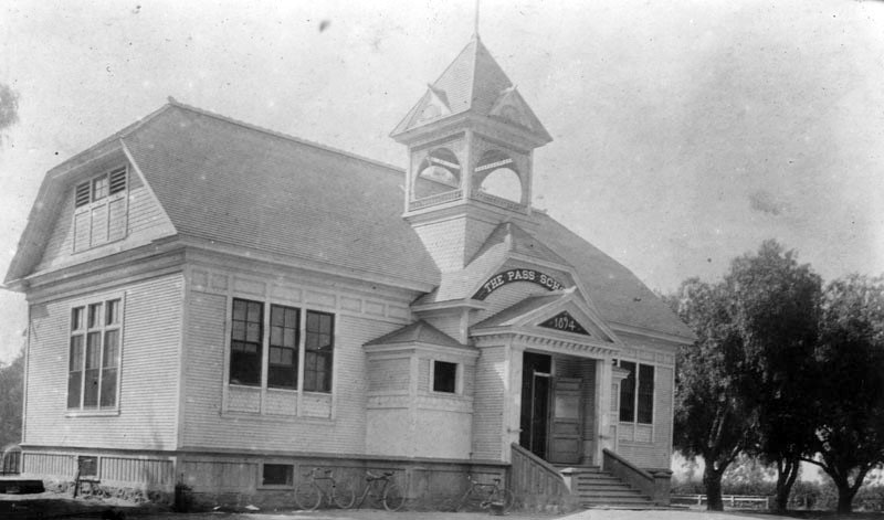
| (ca. 1894)* - Students of the Cahuenga Pass School in Hollywood pose for a class photograph outside of the newly completed school building. |
Historical Notes The Pass School was located at today's intersection of Sunset Boulevard and Gordon Street. The school was constructed in 1894 and contained three classrooms. |
 |
|
| (ca. 1895)* - Exterior view of the Cahuenga Pass School in Hollywood. Bicycles are seen parked in front. |
* * * * * |
 |
|
| (ca. 1895)* - A couple poses outside of the large colonial revival residence located on Carlos Avenue in Hollywood, identified as once having been the home of E. W. Twist. |
Historical Notes In 1916 this house became the first location of the Hollywood Studio Club, an organization and home designed to provide actresses with safety and security while they pursued their careers in Hollywood. |
* * * * * |
Mary Penman Moll House
 |
|
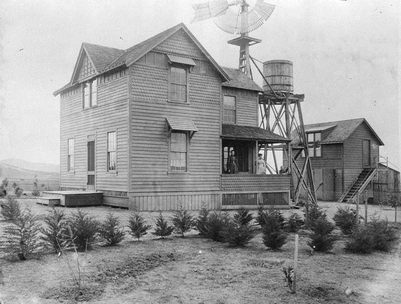
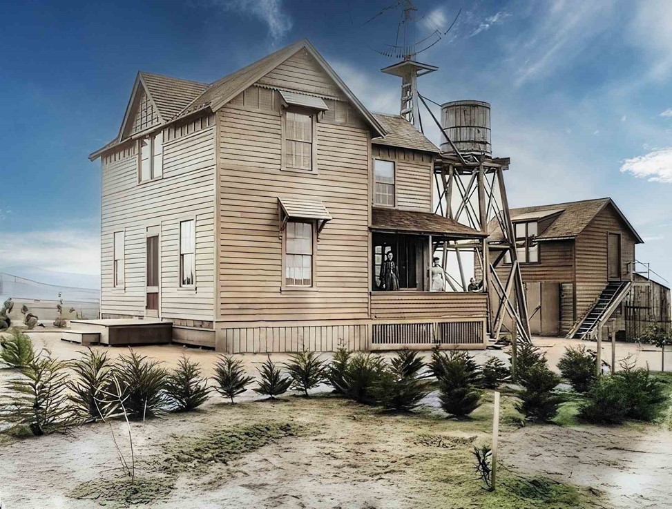
| (ca. 1895)* - Two women and a small child are shown on the porch of a two-story wooden farmhouse located at what is now near the corner of Hollywood and Highland, identified as once having been owned by Mary Penman Moll. A small water storage tower is visible just to the right of the home and in the background is a barn. |
Historical Notes Daniel Penman, Scottish stonemason from San Francisco owned twenty-eight acres at Prospect and Highland Avenues, on the south side of the street to La Brea, where he grew strawberries. Penman’s daughter, Mary Moll, lived in a farmhouse next to the strawberry field. She taught at the Pass School on Sunset Boulevard. After her husband’s death, she successfully subdivided the property over the next two decades. She built a commercial block at Hollywood and Highland and the Bonnie Brier housing tract. Mary Moll was a founder of the Hollywood Business and Professional Woman’s Club. She demolished her farmhouse (seen above) for a commercial building and built a craftsman-style house for herself farther west where the Roosevelt Hotel now stands (see next photo). |
 |
|
| (ca. 1895)* - The Moll House located at what is now near the corner of Hollywood and Highland. Mary Moll was a founder of the Hollywood Business and Professional Woman’s Club. (AI image enhancement and colorization by Richard Holoff) |
Historical Notes According to historian Gregory Paul Williams, author of the ‘The Story of Hollywood’, Mary Penman Moll, Hollywood’s first school teacher, owned a ranch near the corner of Hollywood and Highland next to a strawberry field. A prominent figure in early Hollywood real estate and civic circles, she is credited with petitioning fellow city leaders to change the name of Prospect Avenue to Hollywood Boulevard in 1910—over the fierce objections of her arch-nemesis Daieda Wilcox.* |
* * * * * |
Franklin and Highland
 |
|
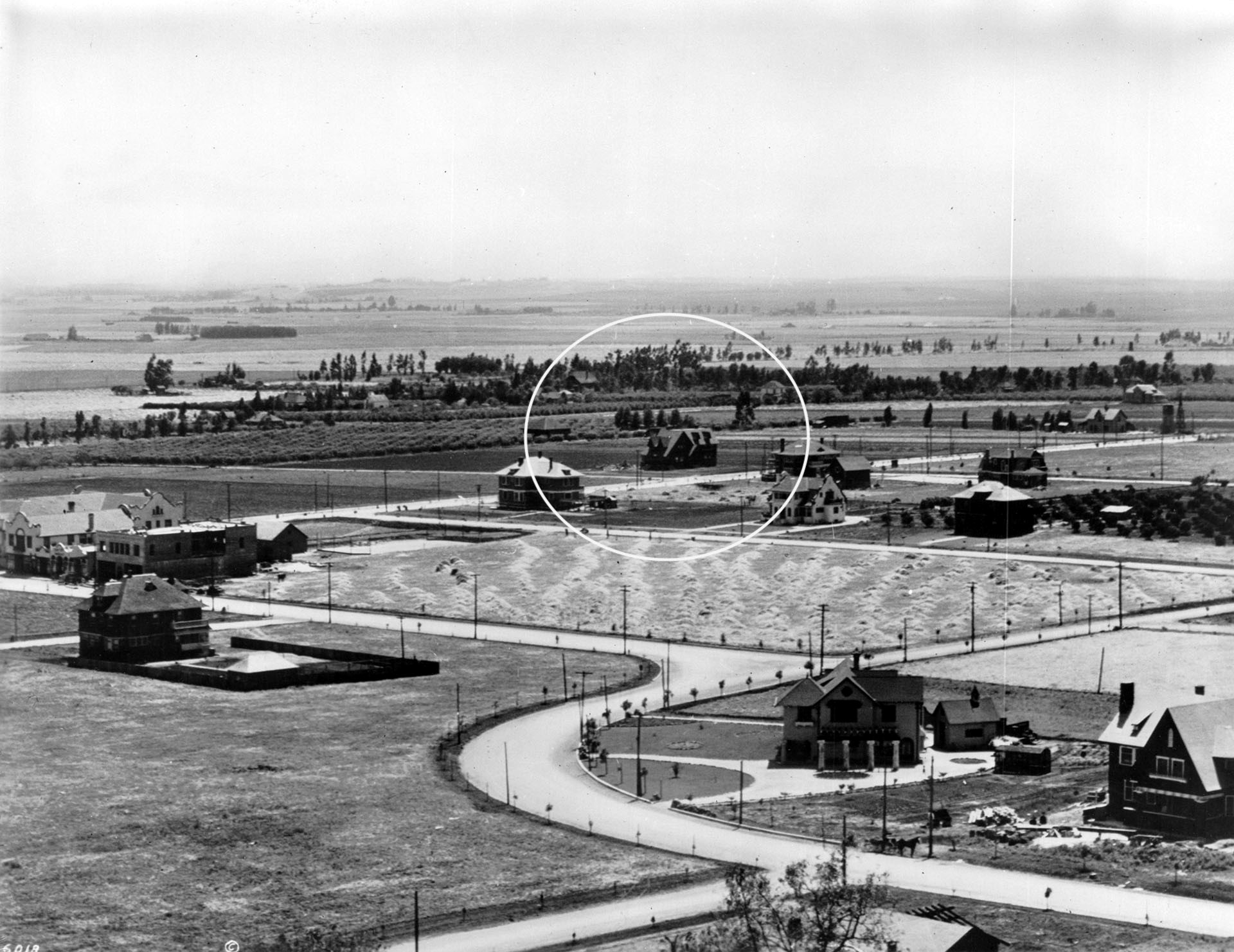
| (ca. 1905)* - View looking southwest showing the intersections of Franklin and Highland avenues. The house circled is Mary Penman Moll's Residence, her second, located on the SW corner of Orange Dr. and Prospect Ave (later Hollywood Blvd), where the Roosevelt Hotel stands today. See previous image for Moll's first residence. |
Historical Notes Mary Moll demolished her first house on the corner of Highland and Prospect (Hollywood Blvd) for a commercial building. She built her second house further west at 7002 Hollywood Blvd, where the Roosevelt Hotel now stands as seen above. Mary Moll’s donation of a strip of land through her property made Highland Avenue official. It was graded, but not paved, in 1901. Highland was the name of the local blacksmith’s wife, Highland Price, who lived with her husband near Fountain. As the first person buried in the Hollywood Cemetery when it opened in 1900, Mrs. Highland Price got a street named in her honor. |
 |
|
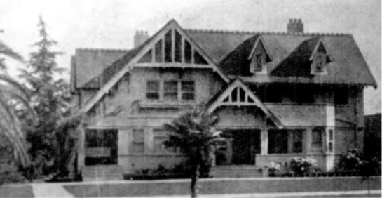
| (ca. 1910s)^ - View looking south showing the craftsman-style home of Mary Moll, located on the SW corner of Orange Drive and Hollywood Boulevard. This would be the site of the Roosevelt Hotel in 1926. |
 |
|
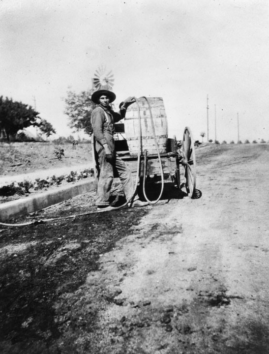
| (ca. 1895)* - Franklin Avenue at Vine Street, Hollywood. A man waters a crop with a hose extended from a water barrel mounted on a cart. A wind mill appears in the background. |
 |
|
| (ca. 1895)* - Orange grove and ranch of Mrs. Wakeman located near Western and Hollywood Boulevard, in Hollywood. |
 |
|
| (1900)* - View Moll's residence and ranch located on the northwest corner of Sunset and Western. In the forefront, a young boy stands posed next to an orange tree. |
 |
|
| (1900)* - View Moll's residence and ranch located on the northwest corner of Sunset and Western. In the forefront, a young boy stands posed next to an orange tree. Image enhancement and colorization by Richard Holoff. |
 |
|
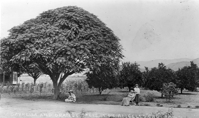
| (ca. 1900)* - View showing a young girl sitting under an umbrella tree. To the right, an older woman is sitting in a rocker with a young boy standing behind her. Orange trees are seen in the background. |
 |
|
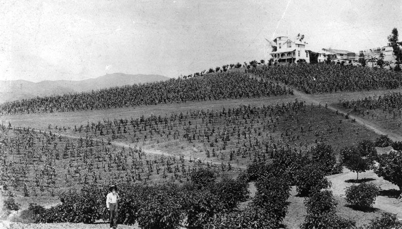
| (ca. 1893)* - Scenic view of a man standing in front of an orange grove on the future Krotona Hill. Several buildings sit on the hill in the background. |
Historical Notes Krotona Hill was named after the Greek school founded by Pythagoras. It was named by the Albert P. Warrington, head of the Theosophical Society settlement, and refers to the 11 acres of land he bought in 1911 west of Beachwood Canyon and north of Franklin Avenue, below where the Hollywood sign stands today, to create an Adyar utopian settlement. In 1924, because of the LA sprawl, the community moved to Ojai, where the Krotona School of Theosophy continues today. |
 |
|
| (1895)* - View looking up Gower and Beachwood from Krotona Hill. The road as seen above was established in the 1870s by Henry and George Claussen. It leads to a two-story home and farm buildings. Beachwood Drive now runs along the bottom of the canyon, and Gower Street runs up the hill by the windmill. |
Historical Notes Beachwood Dr. was named after Hollywood developer Albert H. Beach for whom Beachwood Canyon is also named after. The Canyon was originally known as Claussen Valley (after pioneer resident Henry Claussen). |
 |
|
| (ca. 1895)* - Closer view of Claussen's ranch including what would be known as Krotona Hill. |
 |
|
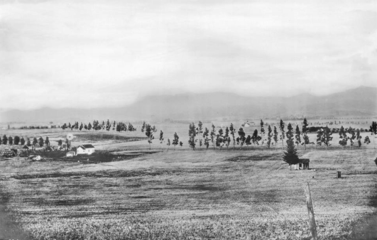
| (1896)* - Panoramic view of Hollywood looking northwest from Olive Hill (later Barnsdall Park). Prospect Avenue (later Hollywood Blvd) runs east-west at bottom and can be seen intersecting Edgemont near the left-center of photo. In the distance are the Hollywood Hills with Mt. Hollywood as the tallest peak. Los Feliz Boulevard is the most northerly road and runs east-west at the base of the mountains. |
Historical Notes Los Feliz Boulevard was dedicated in 1888. It was named after Rancho Los Feliz, a Spanish land grant issued to Cpl. Jose Vicente Feliz, who led the first non-Indian expedition to what became the Pueblo of Los Angeles. Feliz led 11 families here from Sonora, Mexico, in 1781. Most of Feliz's land was the Silver Lake area and the higher slopes of Griffith Park. Rancho Los Feliz sold in the 1850s for $1 an acre. |
 |
|
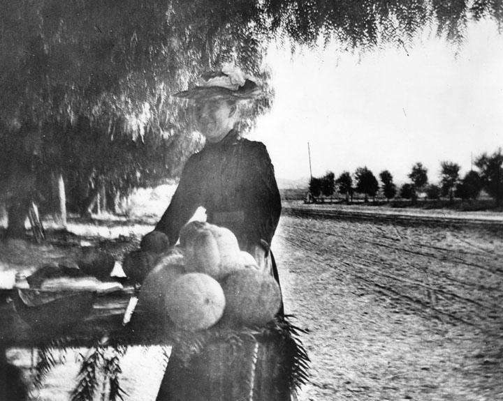
| (1896)* - Early view of Sunset Boulevard just west of Western Ave, looking north. In the foreground is a woman selling melons from a table. |
 |
|
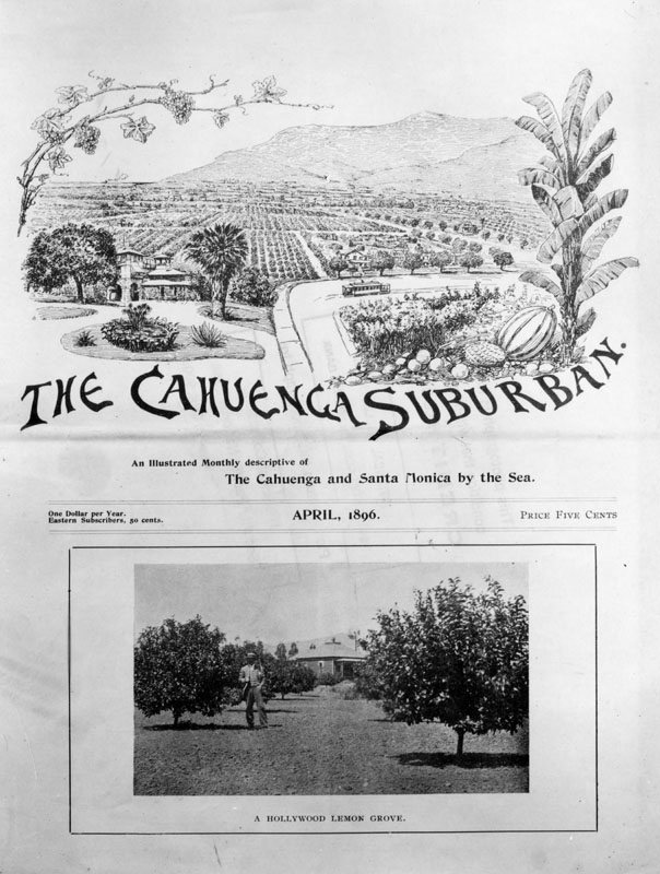
| (1896)* - Photograph of the front page of the Hollywood newspaper, "The Cahuenga Suburban," dated April, 1896. It includes an agricultural drawing and a photo of a Hollywood lemon grove. The drawing includes an electric railroad car and a close-up of various fruits and vegetables. Subtitled, "An Illustrated Monthly descriptive of The Cahuenga and Santa Monica by the Sea," the price is five cents or one dollar per year, 50 cents to eastern subscribers. Click HERE to see Early Views of Santa Monica. |
 |
|
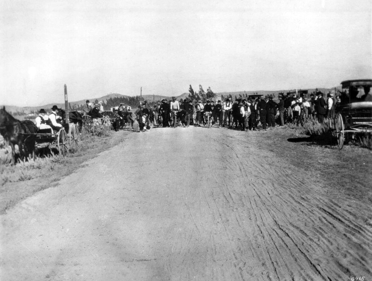
| (1896)* - Bicycle race on Western just north of Santa Monica Boulevard, 1896. |
Historical Notes Western Avenue, apart from Sepulveda Boulevard, is one of the longest north–south streets in Los Angeles. The name of the street is derived from its history as the westernmost border of Los Angeles before annexations in the early 20th century expanded the city. Western Avenue eventually ends north of Franklin Avenue in the Hollywood Hills. It swerves to become an east/west street, Los Feliz Boulevard, a major thoroughfare for Los Feliz. |
* * * * * |
 |
|
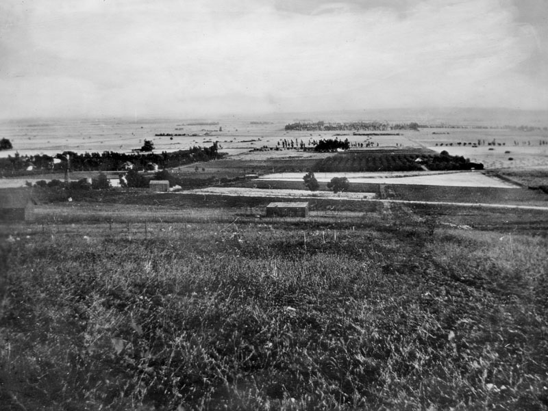
| (1898)^^ – Panoramic view of Hollywood from Vista Street to Franklin Avenue. A homestead with an uncleared field as well as some crop rows is visible beyond the tall grasses that dominate the foreground. Two light-colored buildings stand just behind them to the extreme right of the photograph, with a small stretch of tilled land behind them. Trees are scattered throughout the background. |
* * * * * |
Sackett Hotel – Hollywood’s First Hotel and Community Hub (1888–1910)
 |
|
| (ca. 1888)* – View of the Sackett Hotel shortly after its construction at the southwest corner of Cahuenga and Prospect (later Hollywood Blvd). The three-story Victorian structure, with its bay windows, mansard roof, and second-floor porch, was the first hotel in the Cahuenga Valley. A man, woman, and two children (likely members of the Sackett family) pose in front of the dirt road, with a horse-drawn carriage at right. A woman looks out from the upstairs balcony. |
Historical Notes Horace D. Sackett and his wife Ellen Minerva Sackett built the hotel in 1888 after purchasing the corner lots from Hollywood founder Harvey Wilcox. It was the first lodging establishment in the area and quickly became a multipurpose community center. Their daughter Mary Sackett helped establish Hollywood’s first post office at the site in 1897 and is often considered Hollywood’s first postmistress. The Sacketts also operated a general store on the first floor, serving travelers and local residents alike. |
 |
|
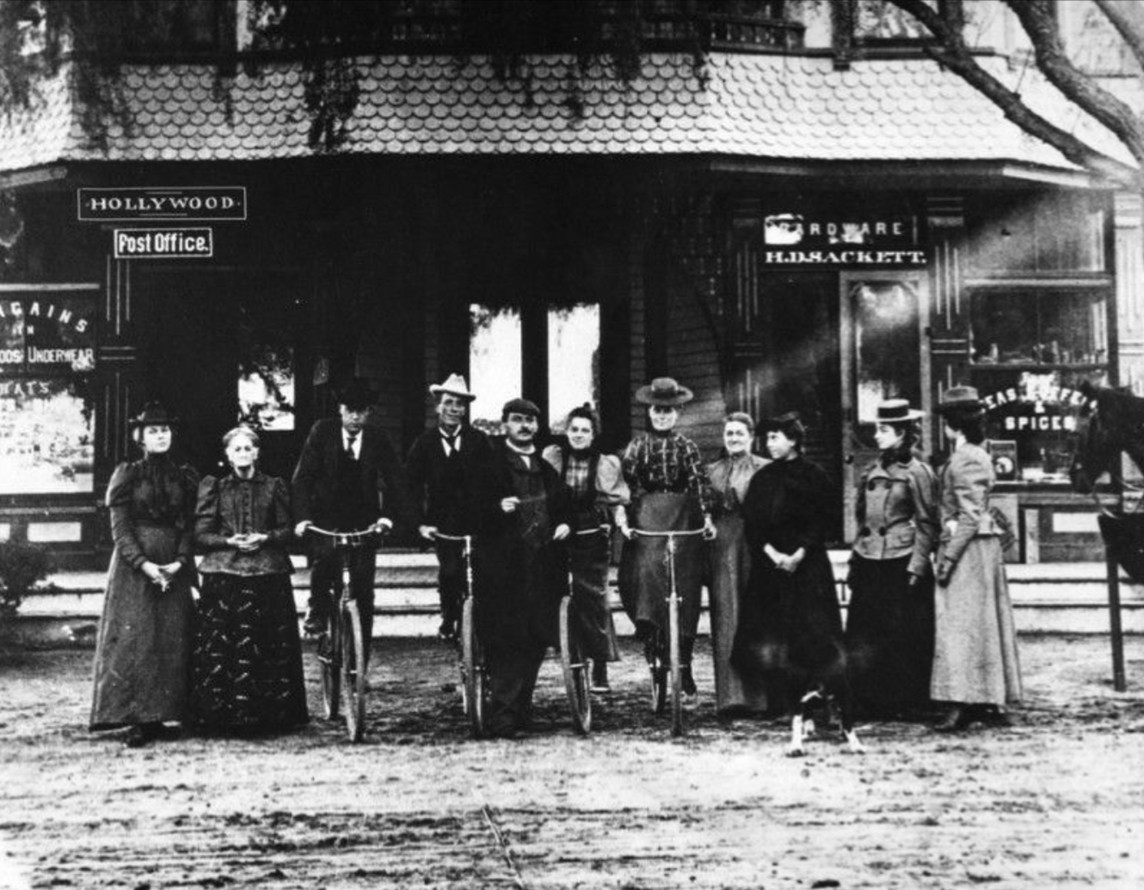
| (1898)* - The extended Sackett family in front of the Sackett Hotel, ten years after its construction. From left to right: Betsy Otis (Horace’s aunt), Ellen Sackett, cousin Lyman Hathaway, William H. Sackett, unknown, Mary Sackett (future postmistress), Zella Sackett (later married George Dunlap), unknown, Lilly (?), and Dora Miller. Two men and two women are seated on bicycles—signs of a growing, mobile community. |
Historical Notes By 1898, the Sackett Hotel had evolved into a key local hub offering lodging, groceries, hardware, and postal service. The building also housed Hollywood’s first general merchandise store, second only to a short-lived 1887 shop. The family grew fruits and vegetables in a back garden for sale in the store, and the site even hosted informal medical visits, community meetings, and horse stabling for guests arriving by rail. The post office had just been added to the hotel in 1897, further solidifying the location as Hollywood’s unofficial civic center. |
 |
|
| (1899)* - Street-level view of the Sackett Hotel and Emporium at the southwest corner of Cahuenga and Hollywood Blvd. Visible on the first floor are the general store, a soda fountain, and the post office. A horse-drawn buggy is parked in front at left. Photo by C. C. Pierce. |
Historical Notes This 1899 photo captures the height of the hotel’s activity, as the Sackett family’s hotel served multiple functions: lodging, post office, general hardware store, and refreshment stop. With only dirt roads and limited infrastructure at the time, the Sackett Hotel stood as a symbol of permanence in a fledgling community. It was an essential stop for landseekers, merchants, and locals alike. |
 |
|
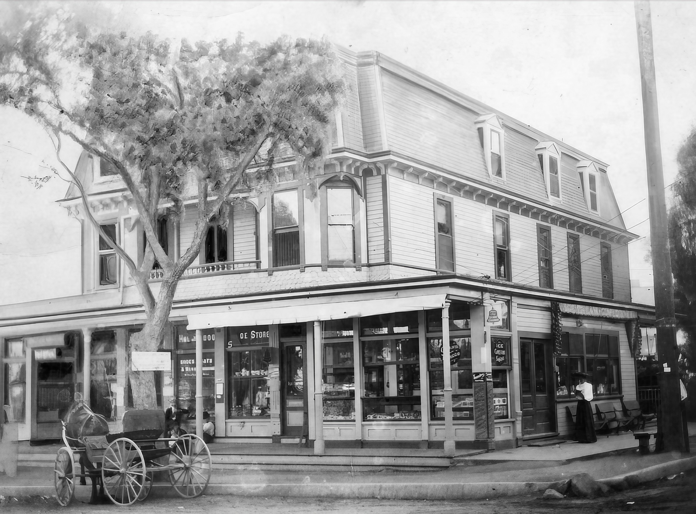
| (1899)* - Enhanced image of the Sackett Hotel and Emporium, offering a clearer view of the signage and storefronts. Signage for “Ice Cream Soda” and “Hardware” is visible, as is the awning shading the sidewalk. A buggy waits at the curb while a woman stands near the entrance. Photo by C. C. Pierce. |
Historical Notes This enhanced version highlights the commercial vibrancy of the site, showing more clearly the range of services offered. Horace Sackett’s store catered to settlers and travelers alike, offering practical goods and farm produce. It was also during this period that Mary Sackett served the community from behind the small postal counter inside. |
 |
|
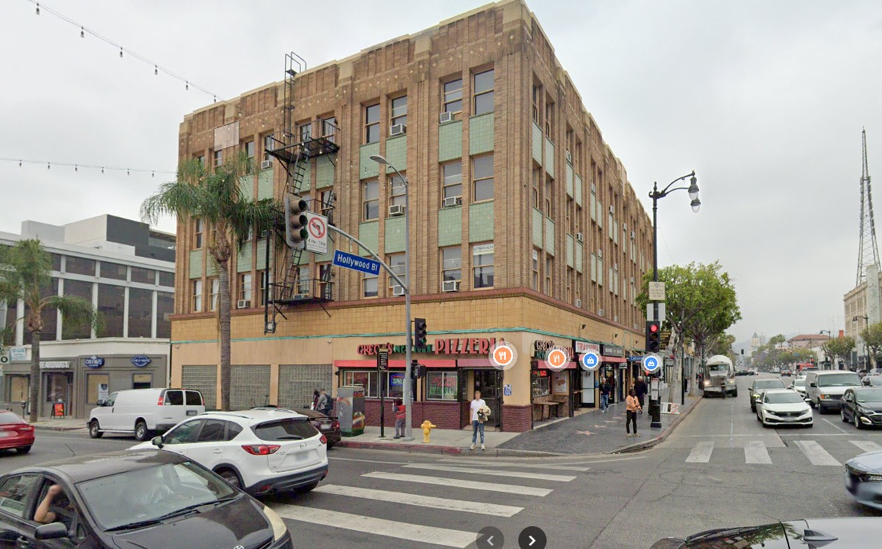
| (2022)* - Contemporary view of the southwest corner of Cahuenga and Hollywood Blvd. Today, the site is occupied by the Creque Building, built in 1911 on the footprint of the former Sackett Hotel. |
Historical Notes The original Sackett Hotel was closed in 1905 after competition from the nearby Hollywood Hotel and changes in the growing city. In 1910, the old wooden structure was demolished and replaced by a fireproof brick commercial building commissioned by J.P. Creque. The Creque Building initially housed the Hollywood National Bank and still stands today. |
Then and Now
 |
|
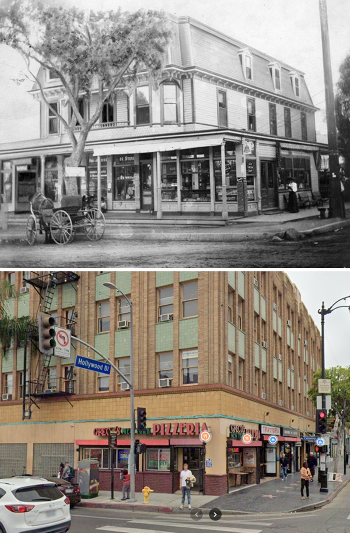
| (1899 vs 2022)* - 'Then and Now' comparison of the southwest corner of Cahuenga and Hollywood Blvd. The top image shows the Sackett Hotel as it appeared in 1899, with its three-story Victorian design and horse-drawn buggy out front. The bottom image shows the same corner in 2022, now occupied by the Creque Building. Comparison by Jack Feldman. |
Historical Notes This side-by-side through time (top: 1899, bottom: 2022) illustrates the transformation of a key Hollywood intersection. In 1888, the Sackett family built what became the area’s first hotel and multipurpose civic center. By 1910, the hotel was demolished and replaced by the Creque Building—reflecting Hollywood’s shift from rustic village to urban commercial center. The original corner was once home to lodging, the first post office, a hardware store, and community life. Today, that legacy survives only in photos and memory. Click HERE to see more on the Sackett Hotel. |
* * * * * |
Hollywood Panoramic
 |
|
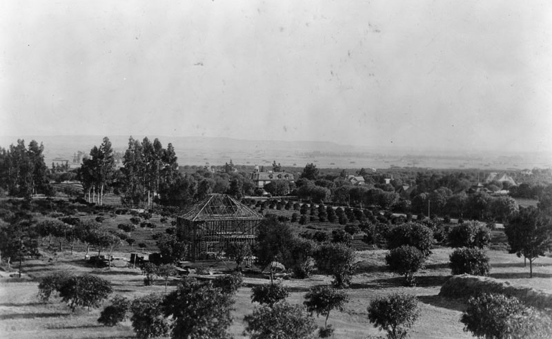
| (ca. 1898)* - Panoramic view of Hollywood in the time of Mr. Wilcox. The orchard in the foreground centers at the later intersection of Hollywood Blvd. and Cahuenga Avenue. A house is under construction. The Sackett Hotel is seen in the center of the photo. |
Historical Notes The Wilcoxes owned a 160-acre ranch named Hollywood, from Gower to Hudson and from Franklin to Sunset. |
 |
|
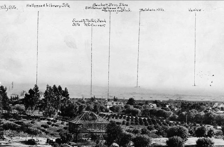
| (ca. 1898)^** - View of Hollywood with annotations. The Sackett Hotel is on the corner of Cahuenga and Hollywood Boulevard at center of photo. |
* * * * * |
Harper Ranch (Sunset and Laurel Canyon)
 |
|
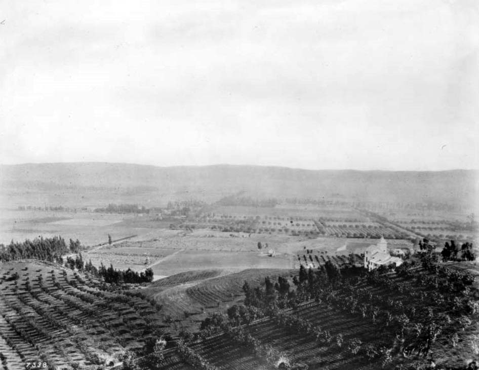
| (1898)* - Panoramic view of the Charles Harper Victorian home and property, standing at the entrance to Laurel Canyon in Hollywood. A man, perhaps Charles Harper, stands in the foreground. |
Historical Notes One of the earliest farming estates was owned by Charles F. Harper, and it dominated the entrance to Laurel Canyon. Harper was a Civil War veteran who immigrated to California and made his fortune in the hardware business. He owned a hardware store on Spring near Temple Street in downtown Los Angeles.* Harper retired in 1895 and moved to Hollywood, where he "enjoyed the evening of his days" on his 480-acre estate in Laurel Canyon. |
 |
|
| (1900)* - View looking east at the foothills of Hollywood showing the 3-story Harper House and Ranch near where Laurel Canyon is situated today. |
Historical Notes Harper Avenue in West Hollywood was named after the Harper family. |
 |
|
| (ca. 1905)* – Panoramic view shwoing the residence and land of Charles Harper located in the mouth of Laurel Canyon, West Hollywood. A man is walking through the agricultural fields. At left is a small house situated just past the row of trees near the base of the mountain. A short way up the mountain stands the Harper residence (center). The Victorian-style house is about three-stories tall. It features an octagonal tower, dormer windows, and steeply inclined roofs. |
Historical Notes The family called the 480-acre estate Cioela Vista but it is generally remembered today as the Harper Ranch. Charles Harper’s son, Arthur Cyprian Harper, who later inherited Cioela Vista, was elected mayor of Los Angeles in 1906. He was forced to resign in 1909, however, when he was threatened with a recall over corruption charges, including allegations he speculated on sugar and that he spent too much time in brothels. |
* * * * * |
Sunset Boulevard, Laurel Canyon, and Crescent Heights
 |
|
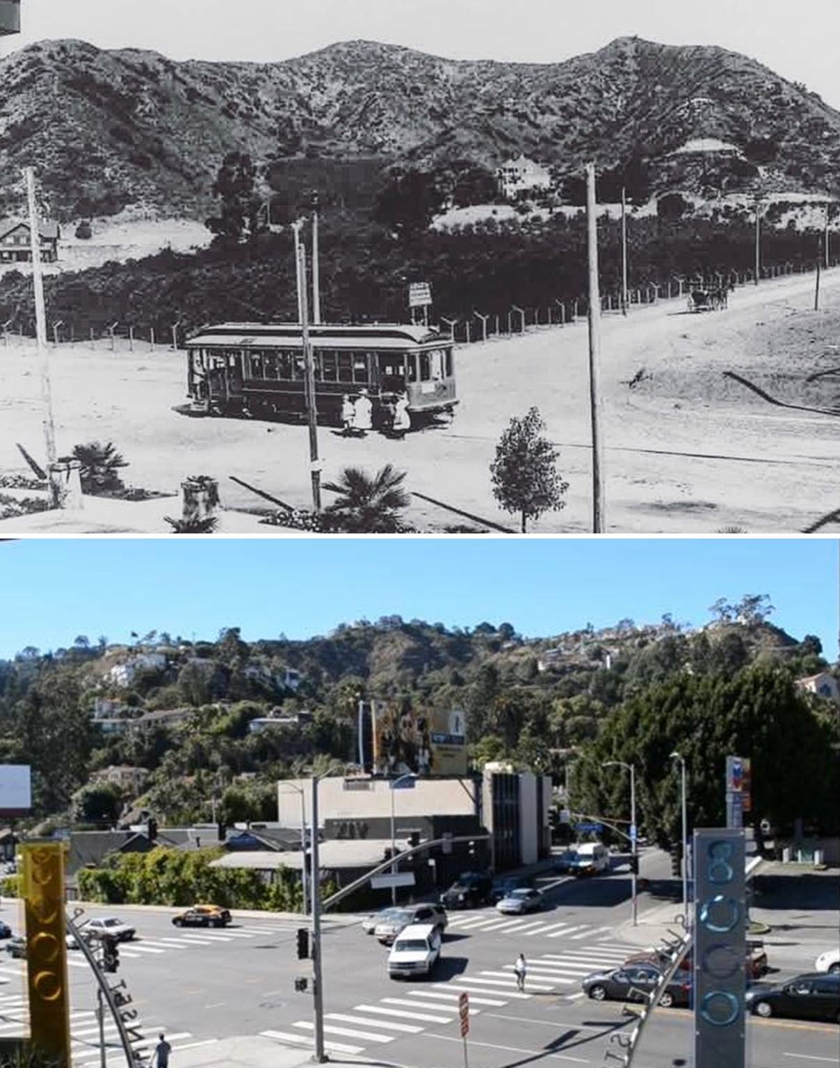
| (1908)* - A streetcar is shown stopped in the middle of Sunset Boulevard, boarding passengers, while a horse-drawn wagon heads north on Laurel Canyon. At the center of the photo can be seen Charles Harper’s 3-story Victorian home. |
Historical Notes In 1908, Sunset Boulevard and Laurel Canyon stood on the brink of major growth. The year before, a new dirt road, which would be named Laurel Canyon Boulevard, was built, giving much easier access to the area. That same year, the Lookout Mountain Park and Water Company was established, acquiring 280 acres on Lookout Mountain to create subdivisions, vacation properties, and ambitious projects like the Lookout Mountain Inn and Wonderland Park. While Sunset Boulevard had been around since the late 1800s, it was still evolving from a simple cattle trail into the famous road it is today. Developers like Charles Spencer Mann were drawn to the area and would soon introduce new transportation options, including the nation’s first commercial trolley bus line, which connected Sunset Boulevard with the top of Lookout Mountain Road. This era marked the beginning of Laurel Canyon’s shift from a quiet, rural area into a popular vacation and residential spot, paving the way for the lively community that would develop over the coming decades. |
 |
|
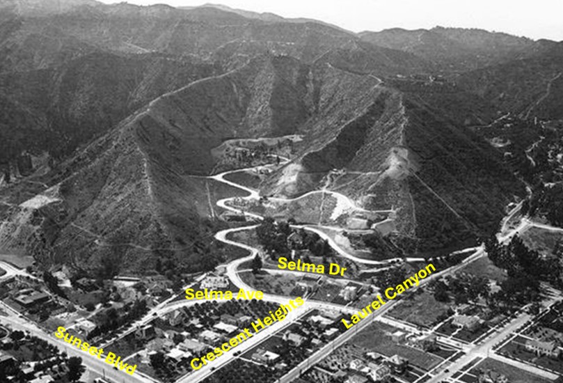
| (1923)* – Aerial view showing Laurel Canyon emerging from the Hollywood Hills and intersecting with Sunset Boulevard, which lies just out of view at the bottom center. Crescent Heights Boulevard runs parallel to Laurel Canyon, appearing to dead-end at Selma Avenue, but it actually continues into the canyon as the zigzag road visible in the image. In later years, Crescent Heights was realigned to converge with Laurel Canyon at Selma Drive. |
Historical Notes Crescent Heights was a pastoral 160-acre tract opened by Charles E. Norton and William H. Hay in 1905 on former Hay family property. At that time, nearby Fairfax Avenue was known as Crescent Avenue, making it fitting for this uphill tract to be called "Crescent Heights." The central road originally ran only between Sunset and Santa Monica Boulevards and temporarily borrowed Sunset’s name until 1913, when it officially became Crescent Heights Boulevard. In the 1920s, it extended further south to encompass additional subdivisions, including Carthay Circle, where Crescent Heights briefly changed names twice—to McCarthy Vista and Carrillo. To travel north from Crescent Heights to Laurel Canyon, one had to zigzag at Sunset Boulevard until the two boulevards were realigned in 1968.* |
 |
|
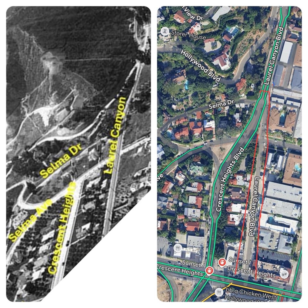
| (1923 vs 2024)* - Crescent Heights and Laurel Canyon before and after realignment, shown in a map and image comparison by Devon Brooks. |
 |
|
| (2024)* - Google Map showing the intersections of Sunset Boulevard and Crescent Heights Boulevard, as well as Sunset Boulevard and Laurel Canyon Boulevard. Note how Crescent Heights continues north past Sunset until it meets Laurel Canyon at Selma Drive. |
 |
|
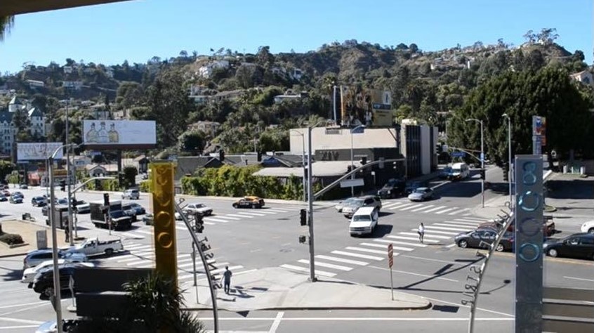
| (2021)* - Looking northwest at the intersection of Sunset and Crescent Heights from the 8000 Sunset Strip Shopping Center. |
Historical Notes Many people think that Crescent Heights Boulevard changes names to Laurel Canyon Boulevard at Sunset Boulevard, but that’s not the case. Crescent Heights actually continues past Sunset, merging with Laurel Canyon Boulevard at Selma Drive. From there, it takes on the name Laurel Canyon Boulevard as it winds through the Hollywood Hills. |
Then and Now
 |
|
| (1908 vs 2021)* - Initially thought to depict the same intersection, this is not the case. The top photo shows Sunset and Laurel Canyon, while the bottom photo captures Sunset and Crescent Heights, located a short block west of Laurel Canyon. Today, Crescent Heights merges with Laurel Canyon two blocks north of Sunset at Selma Drive, continuing as Laurel Canyon through the Hollywood Hills. |
* * * * * |
 |
|
| (ca. 1900)* - View of Hollywood, looking south from what would become Krotona Hill. A large, two-story manor house stands on a hill to the left of the image with orchards arranged own the land beside and below it. In the background, at the bottom of the hill, a small farm cottage can be seen amidst the fields at center, along with a windmill that can be seen to the right. The orchards continue until they meet with the mountains in the background. |
* * * * * |
Paul de Longpré Residence
.jpg) |
|
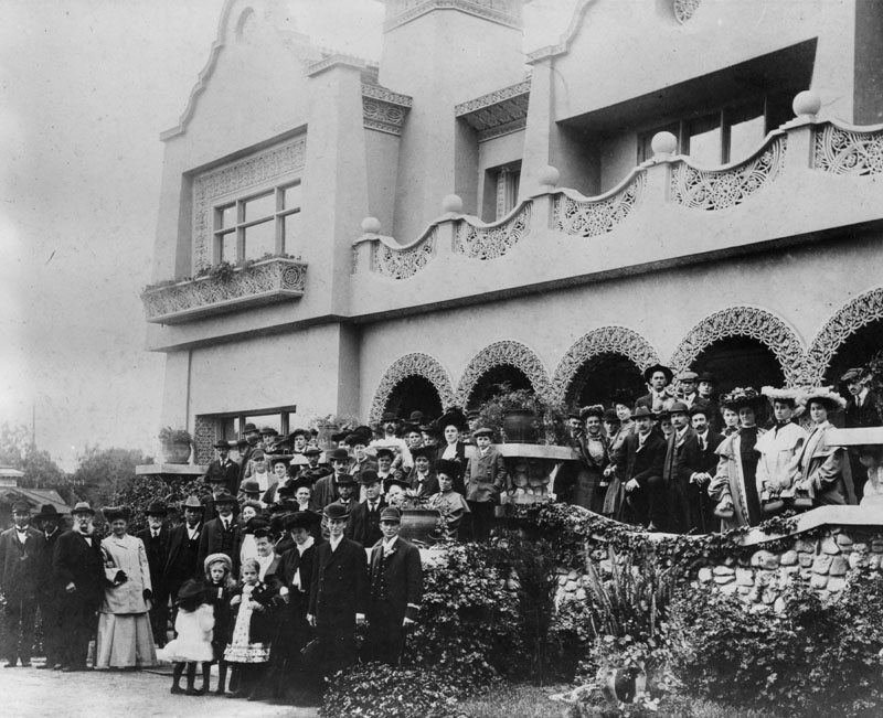
| (ca. 1898)* - Visitors walk through the extensive flower gardens at the Mission Revival/Moorish style Hollywood residence (background) of artist Paul de Longpré. Two men in the foreground appear to be wearing Shriner fezes, suggesting that a special event for the fraternal organization was taking place. The flower garden of the home, located on the west side of Cahuenga Blvd. at Hollywood Blvd., included at one time over 4,000 roses. The residence was a popular destination for tourists who enjoyed the beautiful home, de Longpré's personal art collection and the gardens. |
Historical Notes Perhaps the most famous Hollywood transplant of the time was Paul de Longpre, a French horticultural painter who arrived in Los Angeles with his family in 1889. After de Longpre discovered his ideal flowers growing in Hollywood, he met Daeida Wilcox, who was so anxious to attract culture that she gave him her homesite, three lots on Cahuenga just north of Prospect (later Hollywood Blvd.), for his estate. |
 |
|
| (1899)* - Visitors gather at the entrance of the Mission Revival/Moorish style Hollywood residence of artist Paul de Longpré. |
Historical Notes The mansion and gardens Paul de Longpre built not only drew Hollywood society but served as a lure for new property buyers and tourists. So many visitors came to see “Le Roi des Fleurs” that the P.E. Railway added a trolley spur on Ivar Avenue to deposit them closer to the estate. |
.jpg) |
|
| (ca. 1905)* - View showing a man watering the garden in front of the Mission Revival/Islamic style Hollywood residence once owned by artist Paul de Longpré. The home was located on the west side of Cahuenga Blvd. just north of Hollywood Blvd. Photo by C. C. Pierce |
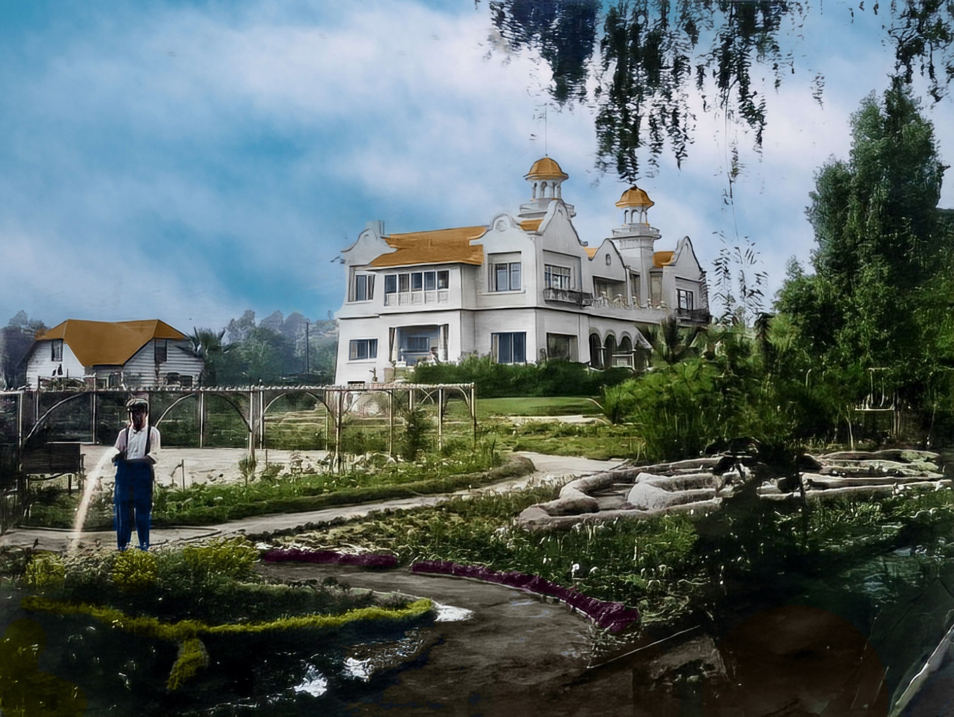 |
|
| (ca. 1905)* - View showing a man watering the garden in front of the Mission Revival/Islamic style Hollywood residence once owned by artist Paul de Longpré. The home was located on the west side of Cahuenga Blvd. just north of Hollywood Blvd. Photo by C. C. Pierce; Image enhancement and colorization by Richard Holoff |
 |
|
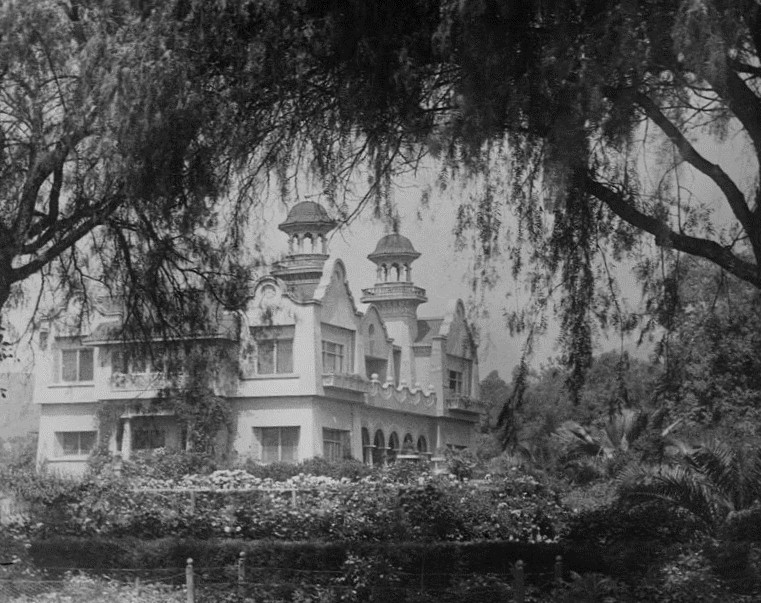
| (1907)* - View of the Hollywood residence and gardens owned by artist Paul de Longpré. The home was located on the west side of Cahuenga Blvd. at Hollywood Blvd. on property he obtained from Mrs. Wilcox Beveridge after he moved to Los Angeles in 1889. The French born artist desired the 65-foot-deep lots for a large flower garden. |
Historical Notes Tours of the house and gardens, along with prints of his floral paintings, supported the de Longpre family until the artist’s death in 1911. After his family returned to France, the house and gardens were demolished for their valuable real estate, and de Longpre’s paintings–romantic still-lifes of roses, orchids and the like–fell permanently out of fashion. |
 |
|
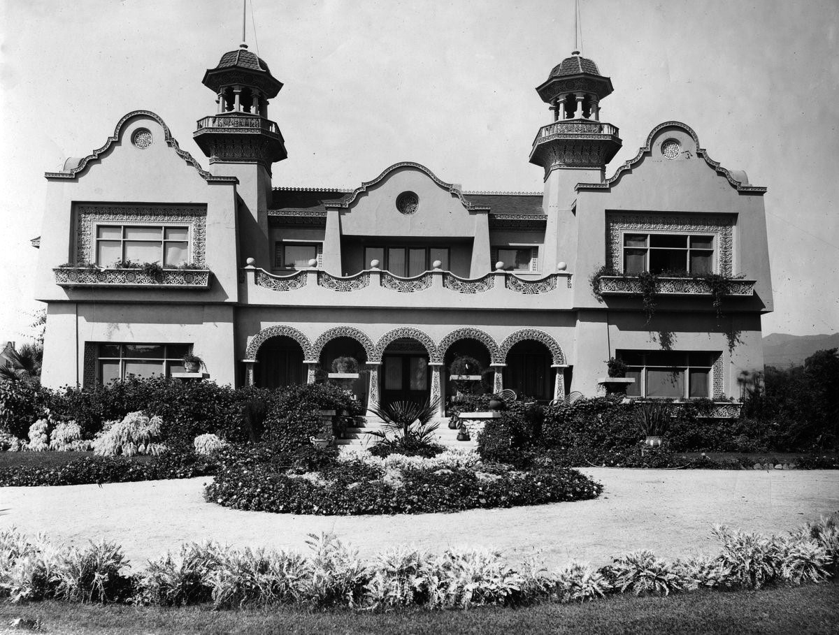
| (Early 1900s)* - Frontal view of the Mission Revival/Islamic style Hollywood residence and gardens owned by artist Paul de Longpré. |
Historical Notes The home was located on the west side of Cahuenga Blvd. at Hollywood Blvd. on property Longpré obtained from Mrs. Wilcox Beveridge after he moved to Los Angeles in 1889. The residence was a popular tourist destination for several years and was demolished in 1927. |
* * * * * |
Cahuenga and Prospect (later Hollywood Blvd)
 |
|
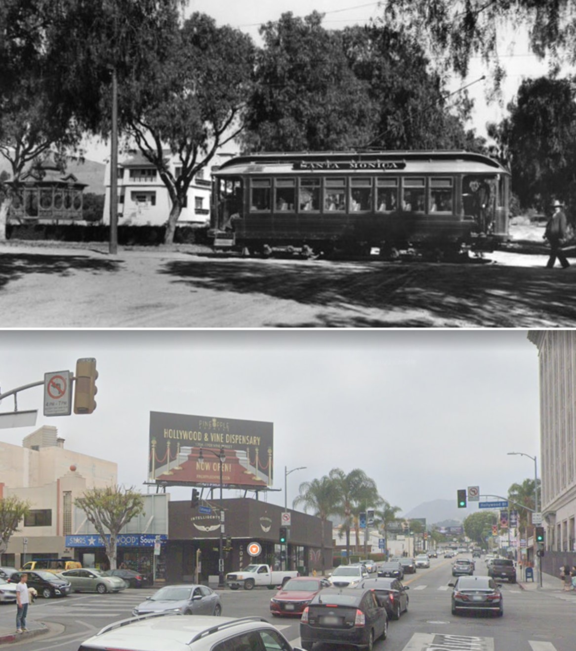
| (ca. 1900)* - View looking north on Cahuenga at Prospect (later Hollywood Blvd.) and a streetcar car with Santa Monica on its side. Paul de Longpré's residence can be seen on the NW corner. |
Historical Notes By 1900, the region had a post office, newspaper, hotel, and two markets along with a population of 500 people. Los Angeles, with a population of 102,479 lay 10 miles east through the vineyards, barley fields, and citrus groves. A single-track streetcar line ran down the middle of Prospect Avenue from it, but service was infrequent and the trip took two hours. The old citrus fruit-packing house was converted into a livery stable, improving transportation for the inhabitants of Hollywood.*^ |
Then and Now
 |
|
| (1900 vs 2022)* - Looking north on Cahuenga at Hollywood Boulevard (then Prospect). |
* * * * * |
 |
|
| (ca. 1900)* - Panoramic view of Hollywood taken from hills near Gower Street and Temple Hill Drive. Some recently-planted orchards are visible. |
 |
|
| (1900)* - View of the Hammel and Denker Ranch. Two men sitting in a horse-drawn carriage watch as workers pick peas in winter. |
Sunset Boulevard
 |
|
| (ca. 1900)* - View looking north on Normandie at Sunset Boulevard. |
.jpg) |
|
| (ca. 1900)* - Early view of Sunset Boulevard east of Beachwood Drive. Two little girls are standing in the middle of the wide dirt road with trees and a barn (?) in the background. Photograph also identified as Sunset Boulevard in 1906 looking east from Vine Street which crosses between buildings. |
* * * * * |
Colegrove
 |
|
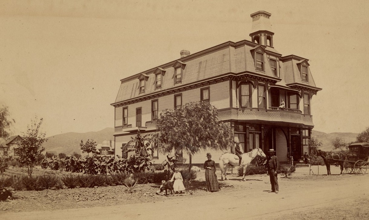
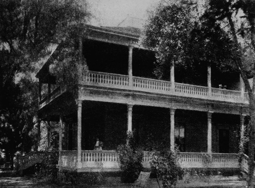
| (ca. 1886)* - View the residence of Senator Cornelius Cole, northwest corner of Santa Monica Boulevard and Gower Street. |
Historical Notes The town of Colegrove began as a 500-acre payment for a former U.S. senator's political influence. In the 1870s, the Hancock family needed help confirming its title to the sprawling Rancho La Brea. In return for the legal services -- and political connections -- of Cornelius Cole, a onetime friend of Abraham Lincoln's, the Hancocks deeded over to Cole a 500-acre tract in the rancho's northeastern corner. Cole subdivided the parcel, named the new settlement after his wife (born Olive Colegrove), and relocated his family to a house on the northwest corner of Santa Monica and Gower, even as he remained with his law practice in San Francisco. |
 |
|
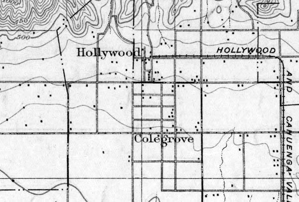
| (1900) – Topographic map showing Hollywood and Colegrove appearing as neighbors. On the right can be seen the Cahuenga Valley Railroad Line running up County Road (later Western Ave) and then turning west on Prospect (later Hollywood Blvd). The east-west street running down the center of the town of Colegrove, Colegrove Boulevard, would later become Santa Monica Blvd. Courtesy of the USGS Historical Topographic Map Collection. |
Historical Notes The Cahuenga Valley Railroad consisted of a steam train that would begin its journey to Cahuenga Valley from Diamond (Beverly Boulevard) and Texas (Belmont Avenue). Leaving the city limits, the little train wandered west across open fields eventually finding County Road where it turned north. County Road later became Western Avenue. Next stop, Coleville or Coles Crossing (later, Santa Monica Boulevard). At this point, the Cahuenga Valley line crossed the steam dummy line to Santa Monica. The train continued north to Prospect Avenue (Hollywood Boulevard) where the line turned west. That was called Grand Round. Today we know it as Hollywood and Western. Next stop, Midway (later called Bronson Avenue). The end of the line was at Prospect Avenue (Hollywood) and Wilcox. |
 |
|
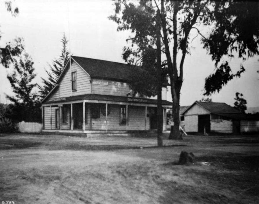
| (ca. 1900)* - The Colegrove general store and post office was located at the town's main intersection, today named Santa Monica and Vine. |
Historical Notes On Oct. 19, 1909, the town's residents voted 84-22 in favor of annexation. Colegrove -- along with other subdivisions in what was known as the Colegrove Addition -- became part of the city of Los Angeles. The following year, Hollywood joined Colegrove by consolidating with Los Angeles. Unlike Hollywood however, Colegrove soon lost its identity as a separate neighborhood. Prior to annexation, the town had referred to its main road as Colegrove Boulevard. But after annexation, Los Angeles insisted that the street be named Santa Monica Boulevard. |
 |
|
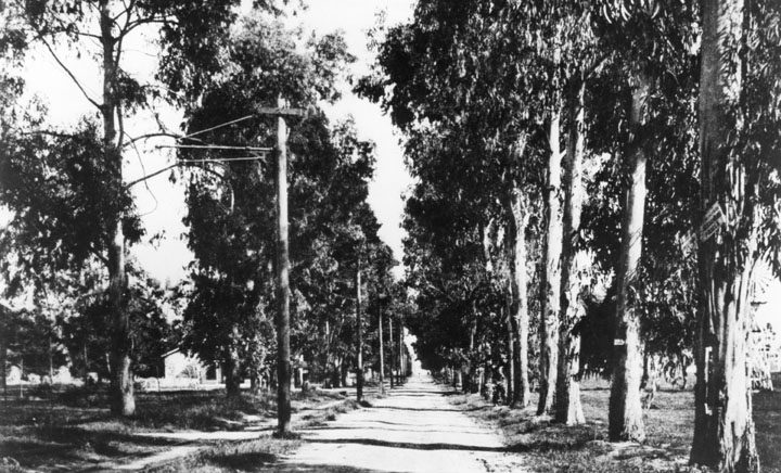
| (ca. 1900)* - View of Santa Monica Boulevard, looking east from Beachwood (formerly Colegrove) Drive. |
Historical Notes Colegrove was originally located in central Hollywood but it eventually stretched as east as Hoover Street and as south as 10th Street (today’s Olympic Blvd). There are several streets now named after the Cole family including: ◆ Barton Avenue -- Barton Jones, grandson of Cornelius Cole. |
* * * * * |
 |
|
| (ca. 1900)* - Panoramic view of the Cahuenga Valley looking north from Prospect Hill, showing the property of G.J. Griffith, Hollywood. A rectangular patch of trees at center is flanked by cleared land to all sides. Just in front of it, to the right, a trollycar moves along the unpaved street, which is lined by small, rounded trees. Crop rows and mountains are visible in the distance. |
 |
|
| (ca. 1900)* - Two men stand on Olive Hill in Hollywood circa 1900. A panoramic view of Hollywood extends to the southwest across what later became Sunset Blvd. at the foot of the hill. Here we see the Prospect Park station, post office, and other buildings. Olive Hill was also known as the Mount of Olives. |
 |
|
| (ca. 1900)* - A panoramic view of Hollywood extends to the north toward the mountains from what would become Barnsdall Park, looking toward a later Hollywood Blvd. and Vermont Avenue area. |
 |
|
| (ca. 1900)* - Panoramic view of Hollywood looking north from Normandie Avenue and Melrose Avenue. A few lines of trees stripe the background along the fences that mark the property lines between two homesteads. In the center ground, a small, one-story house can be seen next to a windmill with a barn further left. On the same property, to the extreme right, a shack can be seen standing next to a lone tree. In the distance behind this shack, a similar homestead whose main building sports a spire can be seen, itself surrounded by a line of thin, young trees. A post, possibly a fence post, is visible in the extreme foreground at right. The Hollywood Hills are visible in the distance. |
Historical Notes The above farm is where the Hollywood Frwy crosses Melrose Avenue today. Just to the west and out of view is the location of the McCarthy Ranch. In 1887 E. A. McCarthy named Melrose Avenue after his hometown of Melrose, Mass. |
 |
|
| (1915)* - A view of the Hollywood Hills (part of the Santa Monica Mountains), taken near the present-day Paramount lot on Melrose Avenue. Photo, Courtesy of the USC libraries - California Historical Society Collection. |
 |
|
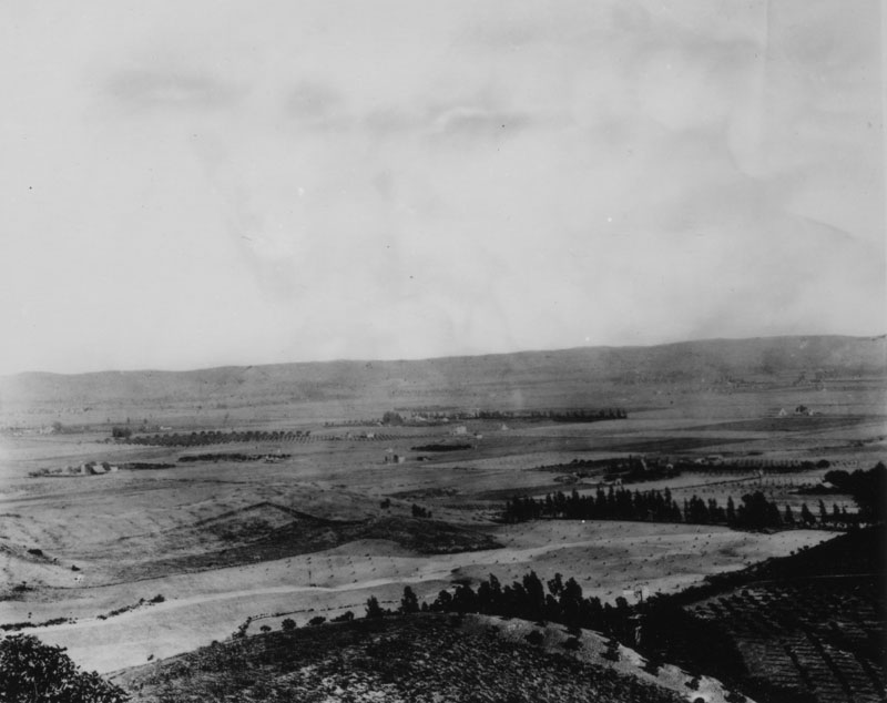
| (1900)* - Panoramic view of Hollywood in 1900, looking across empty space toward a farm and Weid Canyon beyond. The Hollywood hills are seen in the background. |
 |
|
| (1901)* - Undeveloped area of what is now Hollywood and Cahuenga Blvds. The little boy in the lower right of the photograph stands at what will be the northeast corner where the Security Trust & Savings Bank building is later built. |
 |
|
| (1901)* - Panoramic view of Hollywood looking southeast from near Vista Street and Franklin Avenue. The scene is largely agricultural. |
 |
|
| (1901)* - A man walks through a sweet pea field located at about Fairfax and Sunset, in West Hollywood. |
 |
|
| (1901)* - Fields, farm buildings and distant mountains mark the future site of Hollywood High School. Six and a quarter acres were purchased for the high school for $8,000 in 1904. |
 |
|
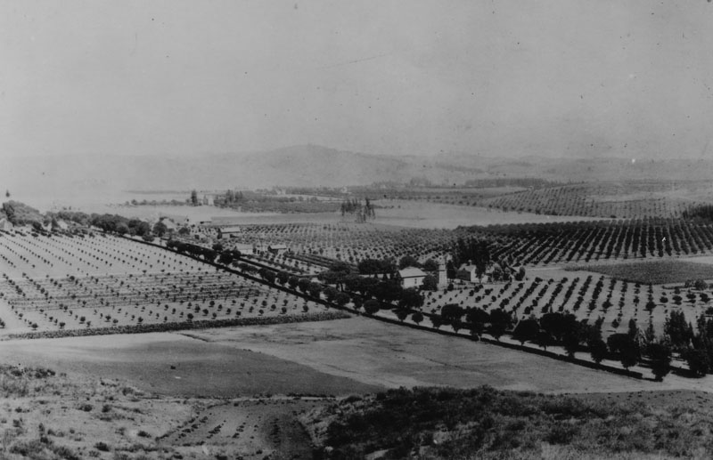
| (1902)* - Panoramic view of Hollywood, looking southeast from Laughlin Park at Franklin and Western Avenues in 1902. Numerous orchards are seen, with a few homes and farm buildings. |
Santa Monica and Western
 |
|
| (1902)* - Tree-lined, unpaved Santa Monica Blvd. at Western looking west in 1902. House on the left is on the southwest corner. A few houses are shown along with a man sitting on a log. Santa Monica Blvd., with a pole line running down its center, looking very narrow in comparison to how it looks today. Click HERE to see contemporary view. |
 |
|
| (ca. 1902)* – Closer view of Santa Monica Boulevard looking west from Western Avenue. Note the pole line running down center of street holding up streetcar wires. |
Santa Monica and Gower
 |
|
| (ca. 1905)* - View of an unpaved Santa Monica Boulevard, where it crosses Gower (foreground). Streetcar tracks running both east and west are visible in the center of the image. |
* * * * * |
Sunset and Fairfax
 |
|
| (1902)* - View looking East on Sunset Boulevard from Fairfax Avenue. Click HERE to see contemporary view. |
* * * * * |
First Grocery Store
 |
|
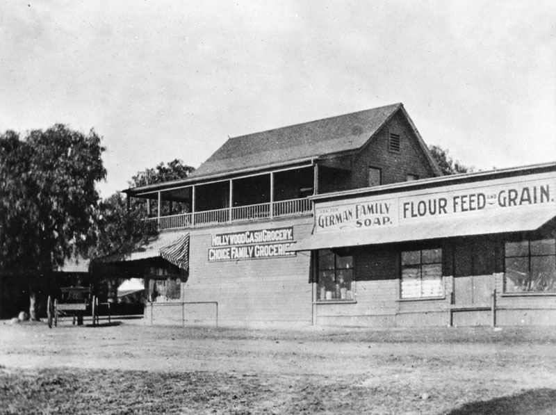
| (1903)* - This was Hollywood's first grocery store, established in the 1890s on the northwest corner of Sunset and Cahuenga. This two-story structure has a few signs on the side of the building which read, "Hollywood cash grocery", "Choice family groceries", "Ask for German family soap", and "Flour feed and grain". A horse and buggy are parked along the store entrance. |
Historical Notes The description above comes from the LAPL image libarary. Gregory Paul Williams in his book The Story of Hollywood identifies this as Jacob Muller’s (who had been the local meat delivery man) “Hollywood Cash Grocery,” which was Hollywood’s first meat market. He says it was located a little further East on Sunset between Ivar and Vine and dates this photo 1893.* |
.jpg) |
|
| (1903)* - A view of West Hollywood from the head of Cherokee Avenue. |
Historical Notes In August, 1903, a petition was submitted to the Los Angeles Board of Supervisors requesting the incorporation of the City of Hollywood. The election for city hood was held on November 14, 1903 with voting lasting until 5:00 PM. After all the ballots were counted, the vote was eighty-eight for incorporation and seventy-seven against. Hollywood became a city with geographic boundaries extending from Normandie on the east, to Fairfax on the west, and from the top of the Santa Monica Mountains on the north to DeLongpre and Fountain avenues on the south. |
 |
|
| (1903)* - Panoramic view of Hollywood, looking southwest from the Cherokee Avenue hill, above Highland Avenue in Whitley Heights. Numerous houses are seen, including that of artist Paul DeLongpre, the residence with two towers near the center of the photograph. It was located on the west side of Cahuenga Blvd. at Hollywood Blvd. |
* * * * * |
Please Support Our CauseWater and Power Associates, Inc. is a non-profit, public service organization dedicated to preserving historical records and photos. Your generosity allows us to continue to disseminate knowledge of the rich and diverse multicultural history of the greater Los Angeles area; to serve as a resource of historical information; and to assist in the preservation of the city's historic records.
|
More Historical Early Views
Newest Additions
Early LA Buildings and City Views
History of Water and Electricity in Los Angeles
* * * * * |
References and Credits
* LA Public Library Image Archive
^*California Historic Landmark Listing (Los Angeles)
#*California Historical Society Digital Archive
#^San Fernando Valley History Digital Library - CSUN Oviatt
**Retronaut: Hollywoodland Sign
*# LA Times: Hollywood Castles and Curious Cures
***http://underthehollywoodsign.wordpress.com/tag/cahuenga-valley-railway/
**^The Story of Hollywood: An Illustrated History by Gregory Paul Williams
**#E-Referate: History of Hollywood
++#Facebook.com: Photos of Los Angeles
+++Hollywood Street Name Origins
*^*Utopia in Hollywood - LA Times
^**Huntington Digital Library Archive
^^^Skyscraperpage.com: Chauenga Valley Railroad
^#^Under the Hollywood Sign: Beachwood Cyn - Krotona Colony
#*^Beachwoodvoice.com: The Cahuenga Valley Railroad
#^^KCET: When the Cahuenga Pass Was Rustic
*^ Wikipedia: Hollywood; Hollywood Athletic Club; Hollywood Bowl; Grauman's Chinese Theatre; Grauman's Egyptian Theatre; Pantages Theatre (Hollywood); The Greek Theatre; Whitley Heights; Hollywood Hotel; Hollywood HIgh School; Nestor Studios; Cahuenga Branch Library; Western Avenue; Cornelius Cole (Colegrove); Hollywood Boulevard
< Back