Piers of Santa Monica Bay
Amusement, Competition, and the Golden Age of the Coast
From the early 1900s through the 1930s, Santa Monica Bay contained one of the greatest concentrations of piers on the West Coast. Built during a period of rapid growth in Southern California, these structures served many purposes. Some were created to attract crowds with rides, entertainment, and spectacle, while others supported fishing, boating, and everyday coastal activity.Together, they transformed the shoreline into a dense and highly competitive coastal landscape. Rail lines, roads, and growing populations turned the beaches into destinations and helped create an era when amusement piers became some of Southern California’s most recognizable landmarks. Most would not survive beyond the Depression era, leaving only a few reminders of what was once one of the most intensely developed recreational coastlines in the nation. |
 |
|
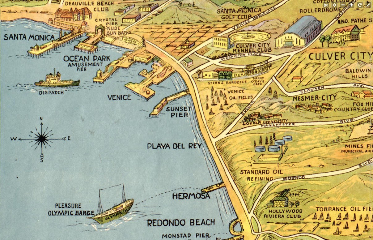
| (1932)* - Map showing the piers of Santa Monica Bay. The coastline is dotted with multiple piers extending from Santa Monica south toward Redondo Beach. A structure labeled Monstad Pier appears near Redondo Beach at lower right. |
| Historical Notes
The 1932 map captures Santa Monica Bay during the height of the pier era, when the coastline supported one of the densest collections of piers in the United States. The greatest concentration appeared around Santa Monica, Ocean Park, and Venice, where neighboring communities competed directly for visitors and investment. The map should be read as a snapshot of what was active and significant at the time rather than a complete record of every structure along the coast. Smaller working piers were often given less attention than amusement destinations that attracted large crowds and generated publicity. Near Redondo Beach, the map identifies Monstad Pier, built in the 1920s by Captain Hans C. Monstad. Unlike the larger amusement piers to the north, it served fishing boats and small craft. Although less well known today, portions of the structure are often described as having influenced or been incorporated into later Redondo pier development. |
 |
|
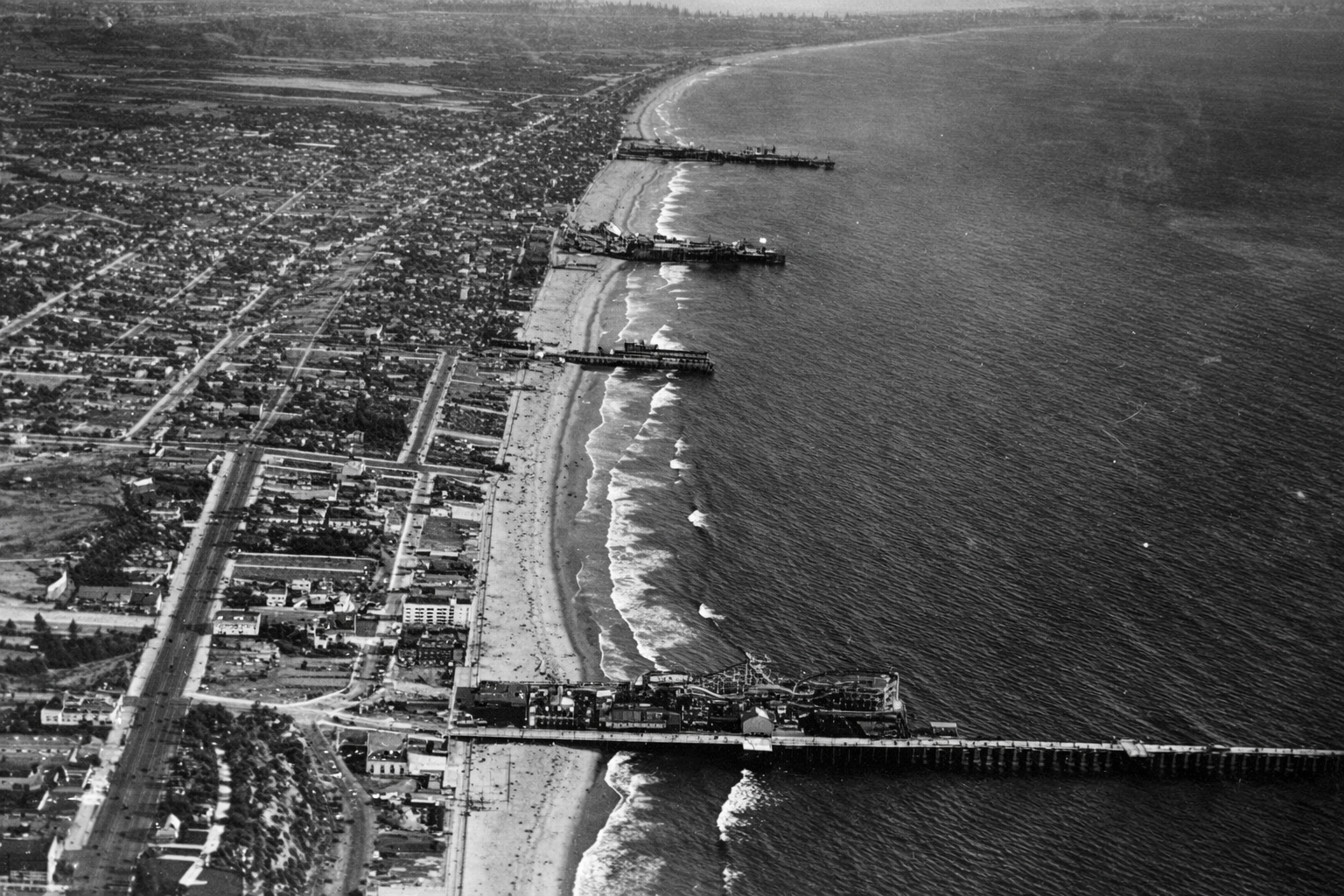
| (1919)* – Aerial view looking south showing four Santa Monica Bay piers. From bottom to top: Santa Monica Pier, Crystal Pier, Ocean Park Pier, and Venice Pier. |
| Historical Notes
This aerial view captures the height of the amusement pier era. Improved transportation, especially electric rail lines, allowed visitors from across the Los Angeles region to reach the coast with ease. Pier owners responded by competing for crowds through larger rides, brighter lights, and increasingly ambitious attractions. The close spacing of these piers created an almost continuous entertainment district along the shoreline. Fires, storms, and structural failures were common because most piers were built largely of wood, yet destruction rarely marked the end. Piers were often rebuilt larger and more elaborate than before, reflecting both optimism and sustained public demand. Not all of these piers survived. Crystal Pier, originally built as White Star Pier and later known as Bristol Pier before becoming Crystal Pier, remained smaller than its neighbors. After years of decline, it was condemned in 1943 and demolished in 1948, marking the gradual end of Santa Monica Bay’s most concentrated era of amusement pier development. |
 |
||
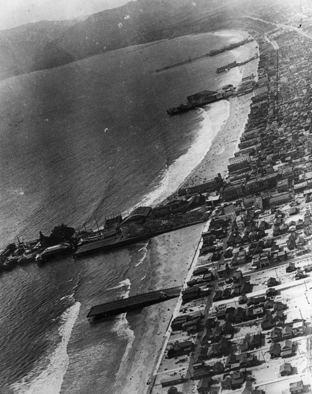
| (1920s)* - Aerial view looking north along the Santa Monica Bay coastline. At least 6 or 7 piers can be seen extending out into the ocean. Venice Pier and amusement park can be seen in the foreground. Ocean Park Pier, with its own amusement park, is the next pier over. Beyond that, the long pier at the top of the photo is Santa Monica Pier, which also developed into a major amusement destination. |
| Historical Notes
During the 1910s and 1920s, Venice, Ocean Park, and Santa Monica functioned less as separate beach towns and more as direct competitors for Southern California's growing tourist market. Each promoted its own mix of rides, entertainment, food, and attractions. Between 1904 and 1925, at least fourteen roller coasters operated along this stretch of coast. The shoreline became a constantly changing landscape of towers, lights, rides, and crowds, creating one of the most concentrated amusement districts in the nation. Visitors could move easily between attractions, producing an almost continuous recreational corridor along Santa Monica Bay. The density seen here would never again be repeated after the Great Depression. Changing economics, evolving entertainment patterns, and the cost of maintaining large wooden structures gradually brought an end to this extraordinary concentration of amusement piers. |
 |
|
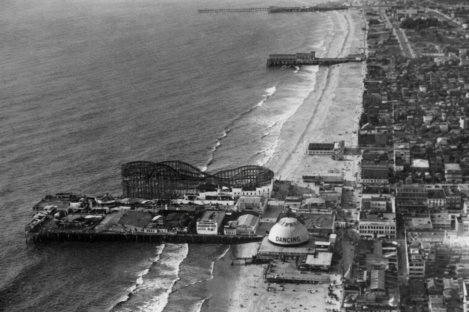
| (1920)* - Aerial view of Ocean Park Pier showing its large roller coaster. The longer pier to the north is Santa Monica Pier, which also developed into a major amusement destination. Between them stands Crystal Pier, originally known as White Star Pier and later Bristol Pier. |
| Historical Notes
Ocean Park Pier became one of the most heavily developed amusement destinations on Santa Monica Bay. Roller coasters were its most visible attraction, but arcades, concessions, and gathering spaces encouraged visitors to spend entire days along the waterfront. The close proximity of Santa Monica Pier, Crystal Pier, and Ocean Park created a layered entertainment landscape unlike anywhere else on the Southern California coast. Success depended not only on location but also on scale, novelty, and the ability to attract repeat visitors. Crystal Pier served as a smaller companion to the larger amusement complexes nearby and changed ownership several times during its history. As entertainment patterns shifted and maintenance costs increased, many of the bay’s early piers disappeared or were rebuilt, leaving Santa Monica Pier as the most recognizable surviving landmark of Santa Monica Bay’s amusement era. Click HERE to see more in Early Views of Southern California Amusement Parks |
 |
|
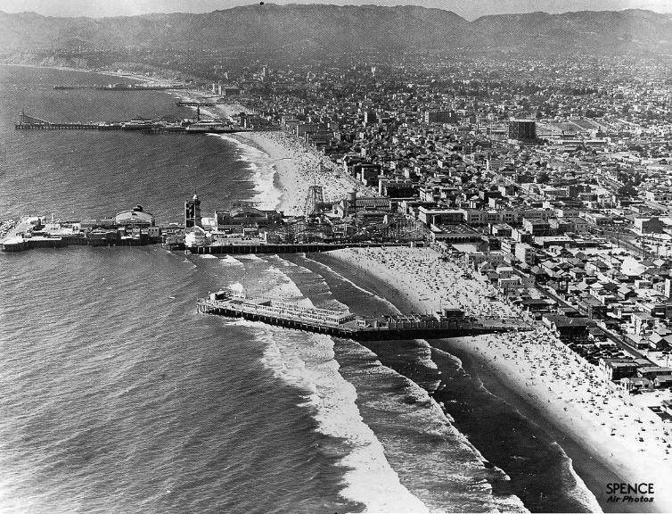
| (ca. 1930s)* – Aerial view showing the pleasure piers of Venice and Santa Monica. From bottom to top: Sunset Pier, Venice Pier, Ocean Park Pier, Crystal Pier, Santa Monica Pier…all that remains are the rocks of the breakwater behind the Venice Pier and the Santa Monica Pier. Photo taken by Spence Air Photos. |
| Historical Notes
This aerial view captures the final years of the great amusement pier era along Santa Monica Bay. Stretching from Venice north to Santa Monica, these five piers created one of the most concentrated recreational landscapes on the West Coast. By the time this photograph was taken, however, the period of rapid expansion and competition was already beginning to fade. Several of the piers shown here disappeared within the following decades. Sunset Pier and Venice Pier were among the earliest losses as changing conditions and expiring leases brought an end to their operations. Ocean Park later evolved into Pacific Ocean Park, a major amusement destination that operated from 1958 to 1967 before closing and eventually being demolished. Crystal Pier, visible between Ocean Park and Santa Monica, had already entered decline and was condemned in 1943 before being demolished in 1948. Of the five piers shown in this photograph, only Santa Monica Pier survives today as a functioning pier and direct continuation of the amusement era shown here. Its longevity owed less to amusement attractions than to its municipal role and later preservation efforts that prevented demolition during the 1970s. The original Venice amusement pier and the other recreational piers shown here have long since disappeared, leaving Santa Monica as the last standing reminder of one of Southern California’s most remarkable periods of coastal recreation and entertainment. |
 |
|
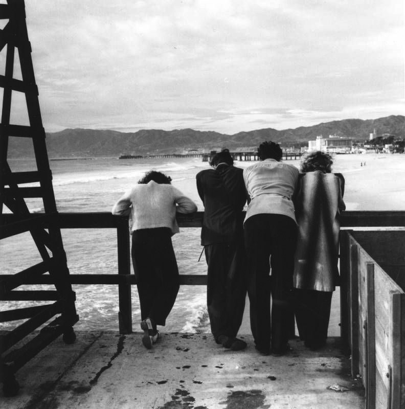
| (ca. 1940)* - Four people stand on Ocean Park Pier looking north toward Santa Monica, with Crystal Pier and Santa Monica Pier visible in the distance. Photograph by Ansel Adams. |
| Historical Notes
This quiet scene provides a striking contrast to the crowded amusement views that defined Santa Monica Bay during earlier decades. Rather than emphasizing rides, lights, and spectacle, the photograph focuses on atmosphere, distance, and the changing relationship between people and the shoreline. By around 1940, the great amusement pier era had begun to fade. Economic pressures, aging wooden structures, storms, and changing patterns of recreation gradually transformed the coastline. What had once been one of the most intensely developed recreational corridors on the West Coast was becoming quieter and less crowded. Photographed by Ansel Adams during his 1940 documentary work in Los Angeles, the image captures a moment of transition along a shoreline that had already begun its long transformation away from the amusement era. |
Click HERE to see more in Early Views of Santa Monica |
* * * * * |
Research, writing, and image curation by Jack Feldman, Water and Power Associates, with editorial assistance.
* * * * * |
|
Other Sections of Interest |
|
Water and Power in Early LA |
|
Newest Additions |
New Search Index |

A new SEARCH INDEX has been added to help navigate through the thousands of topics and images found in our collection. Try it out for a test run.
Click HERE for Search Index |
* * * * * |
< Back