Mid-Wilshire and the 'Miracle Mile' (1920s & 1930s)
Introduction |
In the early 1920s, the stretch of Wilshire Boulevard that would later be called the Miracle Mile stood at the edge of Los Angeles. It was not yet a corridor of theaters, towers, and department stores. Instead, it was a wide open landscape marked by oil derricks, dirt roads, tar seeps, and scattered ranch structures. The city had not quite reached this far west, but the forces that would shape modern Los Angeles were already gathering here.Beneath the surface lay the Salt Lake Oil Field, one of the most productive oil districts in early Los Angeles. Above ground, a narrow Wilshire cut across the flats, carrying modest traffic toward farmland and oil leases. For a brief period, the future crossroads of Wilshire and Fairfax even hosted aviation fields that drew spectators and parked cars. Oil, transportation, and visibility were already giving this district strategic importance. Within a decade, those same qualities would make it the site of one of the most ambitious commercial experiments in the city. |
La Brea Tar Pits and the Oil Field |
1900 to 1925 |
 |
|
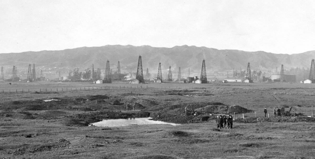
| (ca. 1910)* - View looking north from where Wilshire Boulevard runs today, showing men standing beside a tar pond in the area known as the La Brea Tar Pits. Oil derricks belonging to the Hancock family stand beyond the pond. Further north, derricks of A. F. Gilmore Oil Company rise against the skyline. |
Historical Notes Long before large scale drilling began, natural asphalt seeped to the surface in this area. These tar deposits gave the district its name and signaled the presence of petroleum underground. The Spanish word brea means tar, and La Brea became part of the identity of the rancho lands later associated with the Hancock family. The same geologic forces that created the tar pits also formed the Salt Lake Oil Field. In the early twentieth century, drilling operations spread across this landscape. Derricks soon surrounded the tar seeps, transforming what had once been open ranch land into an industrial zone. This image shows the earliest stage of that transformation, when natural features and oil production still existed side by side. |
 |
|
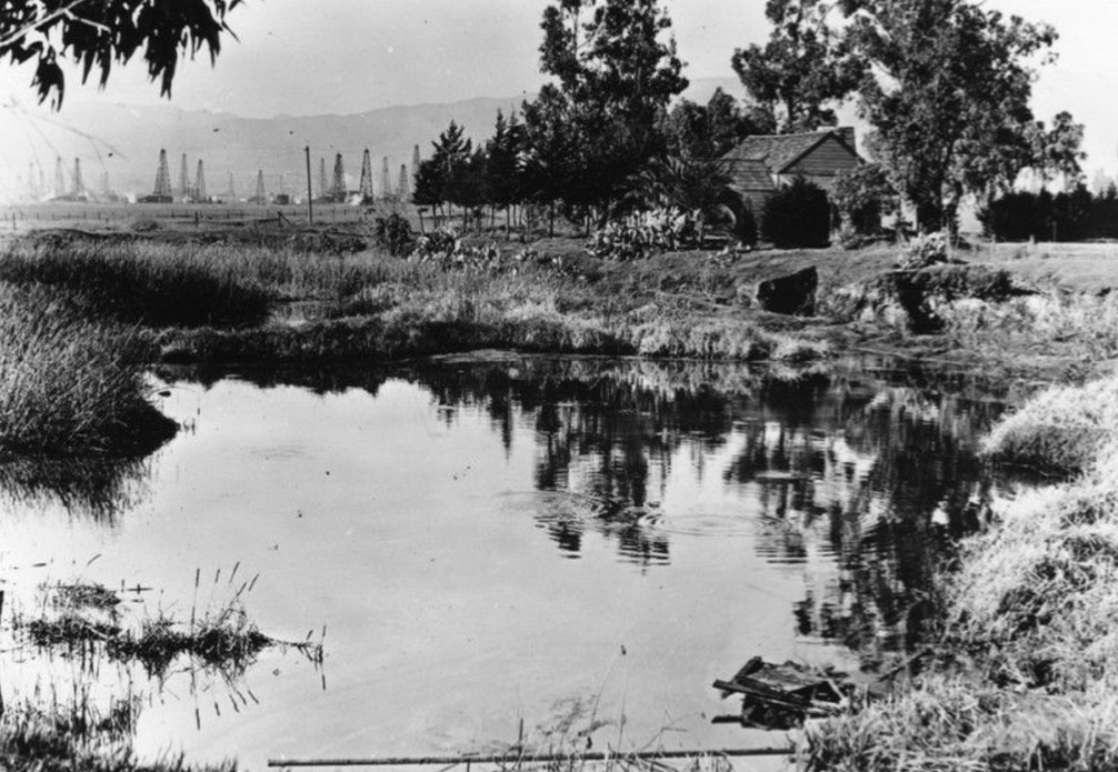
| (ca. 1910)* - Standing on the edge of a tar pond, we look across toward the old Hancock Ranch House. Oil fields stretch into the distance. Behind the camera is where Wilshire Boulevard runs today. |
Historical Notes Rancho La Brea passed into the hands of Henry Hancock in 1860 after years of legal disputes involving the original Rocha family claim. The rancho included the tar pits and surrounding pasture land. Hancock recognized the commercial value of the asphalt deposits and began selling asphalt from the property. In the early 1900s, portions of the rancho were leased for oil drilling. By 1907, more than seventy wells were producing oil, and the Hancock family became deeply involved in the growing petroleum industry. This photograph captures the moment when a former ranch landscape was giving way to oil development. The ranch house stands as a reminder of the earlier era, while derricks signal the industrial future. |
 |
|
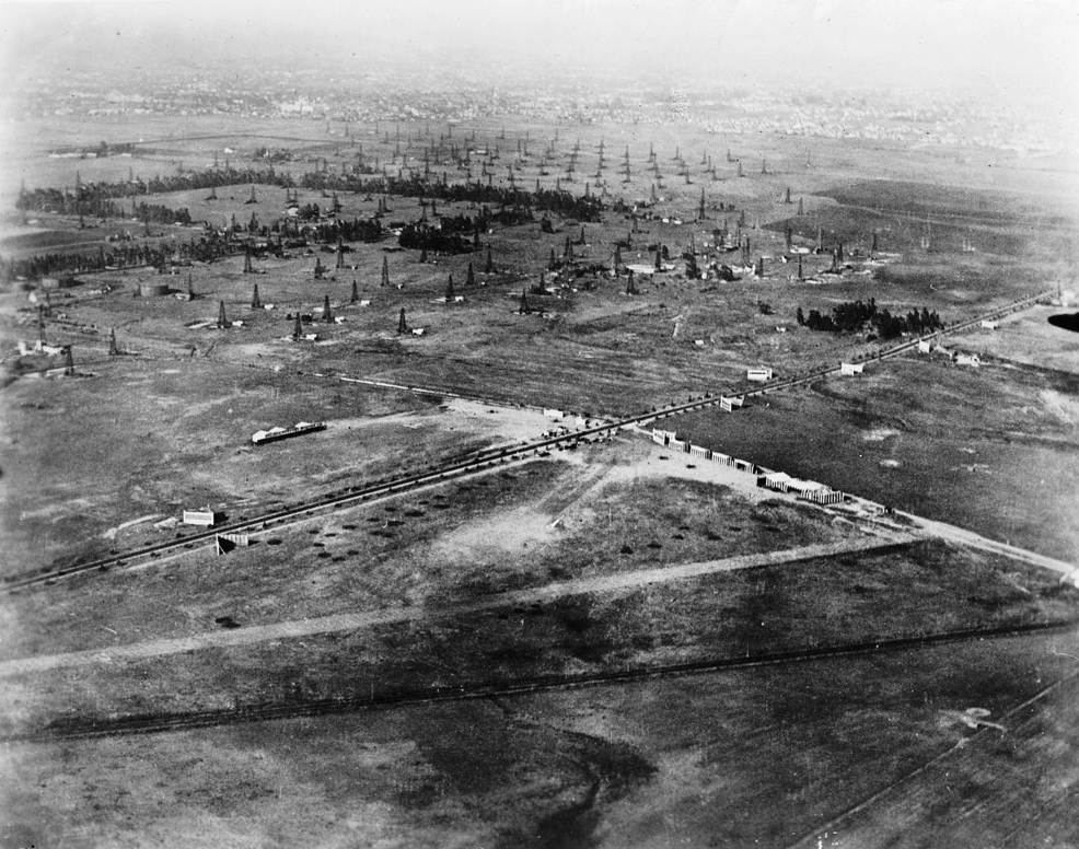
| (ca. 1920)* - Aerial view of the La Brea Tar Pits and surrounding oil derricks. The tar pits appear among trees and open ground, with derricks rising beyond. |
Historical Notes Seen from the air, the relationship between natural tar deposits and oil production becomes clear. The pits occupy low ground while derricks cover the surrounding flats. Roads are few and housing is limited. At this stage, the district was still defined by extraction. The wide open spacing of wells and the absence of dense construction reveal how undeveloped the area remained just before large scale urban growth began. |
 |
|
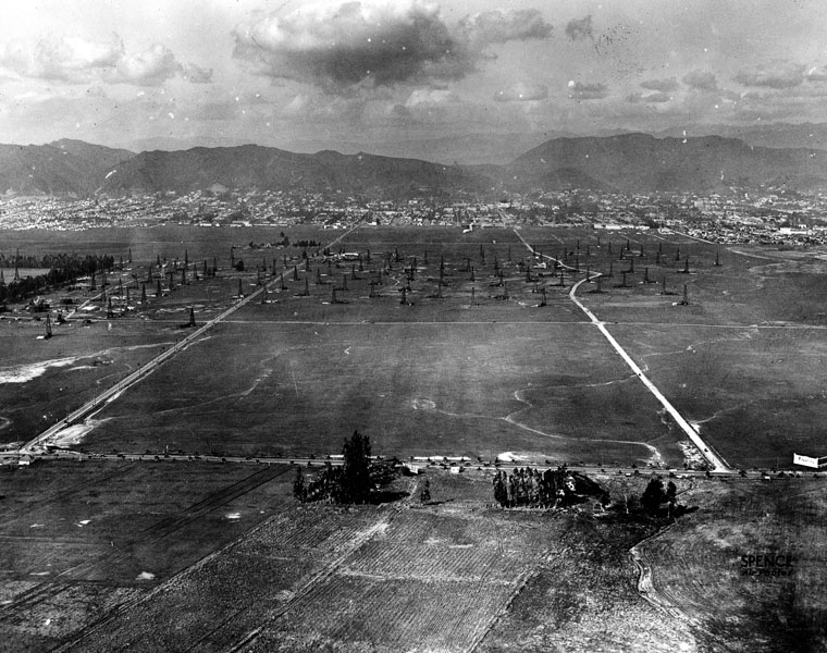
| (1922)* - Aerial view looking northwest. Crescent Avenue, later renamed Fairfax Avenue, crosses Wilshire Boulevard and angles toward the Hollywood Hills. Oil derricks cover much of the open land. |
Historical Notes By 1922, this section of Wilshire was still dominated by the Salt Lake Oil Field. Derricks fill the flats, and the street grid is only beginning to take shape. Fairfax, then called Crescent Avenue, cuts north toward the hills while Wilshire runs thin and straight across an industrial landscape. This image shows how much open frontage existed here before the Miracle Mile. The wide spacing of roads and the lack of tall buildings made the land easier to reshape once oil production declined. |
 |
|
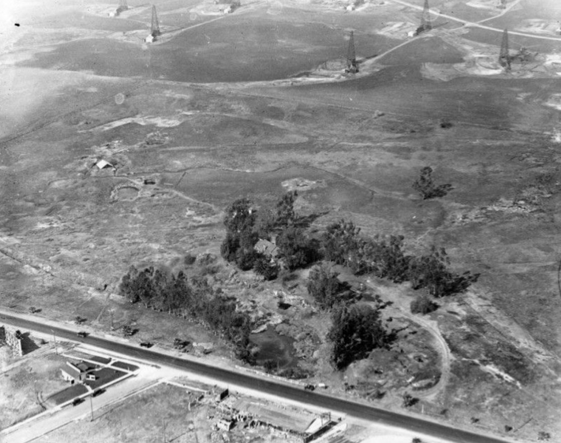
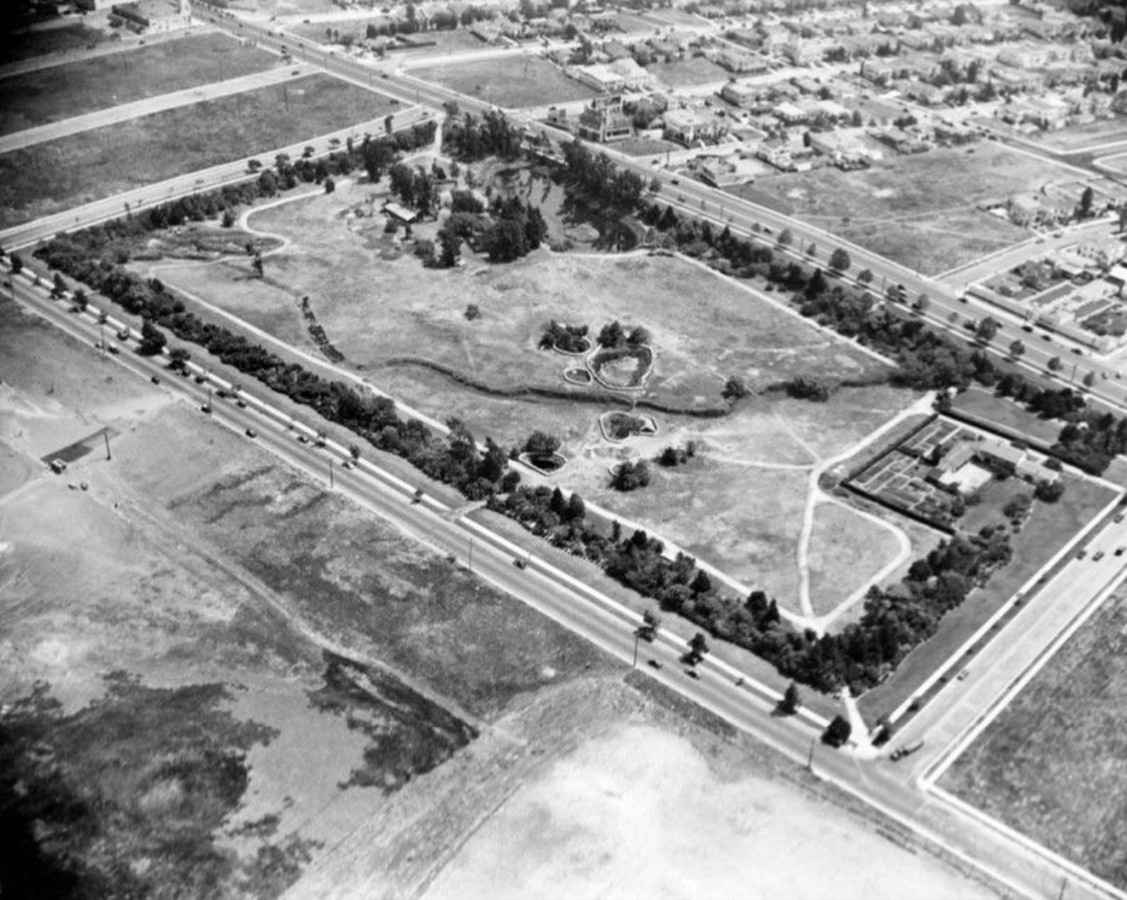
| (1924)* – Aerial view looking southeast showing the La Brea Tar Pits and new housing development. Wilshire Boulevard runs diagonally at upper right. Curson Avenue appears at upper left and Sixth Street runs diagonally at bottom. |
Historical Notes After its peak between 1908 and 1917, oil production in the Salt Lake Oil Field declined. At the same time, Los Angeles expanded rapidly westward. Land values rose as housing and commercial demand increased. This image captures that turning point. New homes begin to appear at the edges of the former oil district. Wells were gradually abandoned, and many were later covered by streets and foundations. The land was beginning its transition from industrial use to residential development. |
 |
|
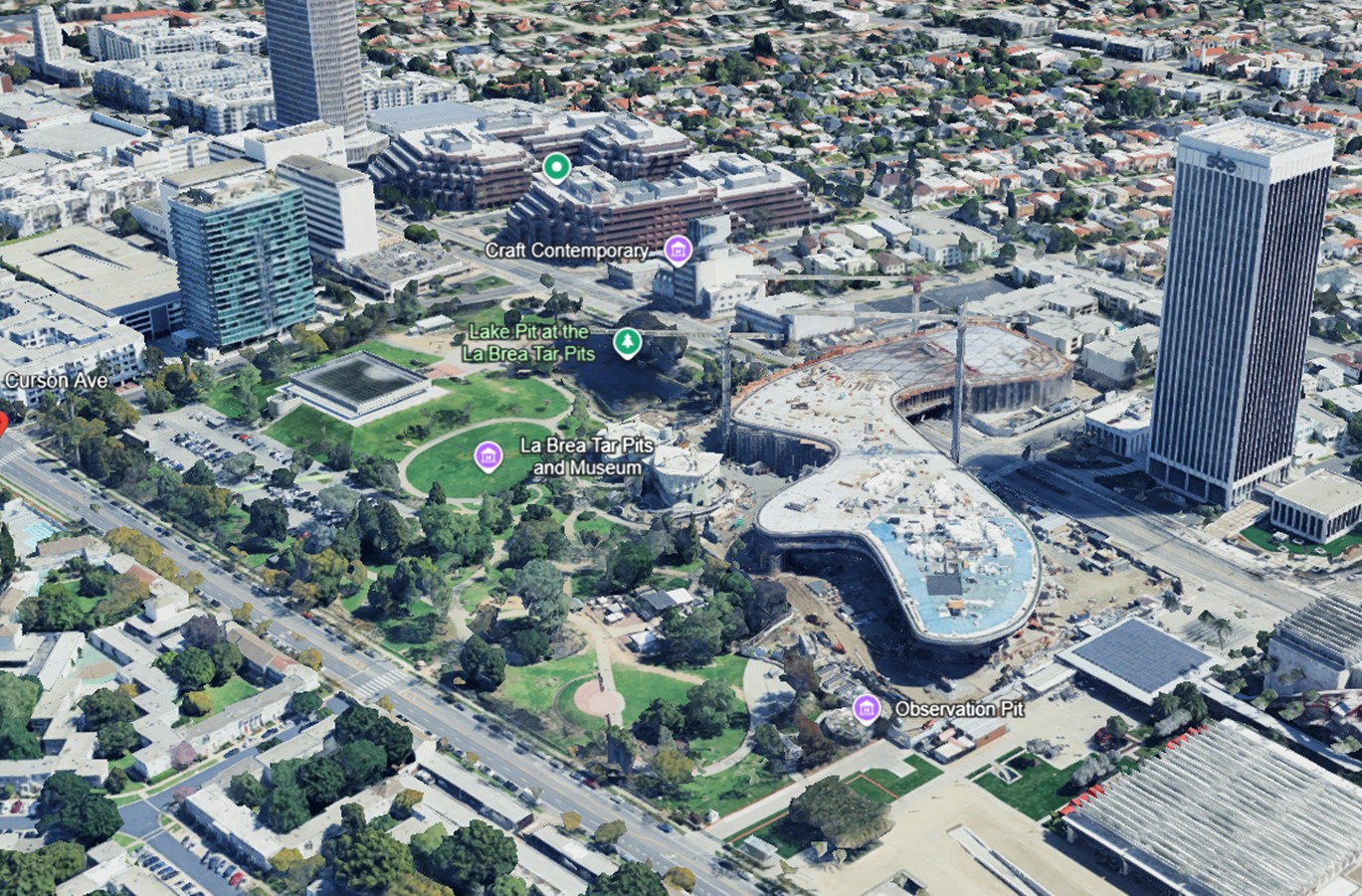
| (2023)* – Aerial view of the La Brea Tar Pits and the Los Angeles County Museum of Art campus during construction. Wilshire Boulevard runs along the upper edge, Sixth Street at lower left, and Curson Avenue at upper left. Image date: 12/1/2023. |
| Historical Notes
A century after oil derricks surrounded the tar seeps, the landscape has been reshaped into one of Los Angeles’ most important cultural districts. The La Brea Tar Pits were preserved as public open space and scientific excavation site, while surrounding oil lands were gradually redeveloped for housing, retail, and institutions. The Los Angeles County Museum of Art, first opened in 1965, established Wilshire Boulevard as a cultural corridor. Subsequent expansions and the new campus now under construction continue that evolution. Although the derricks are gone, the tar remains. Beneath the lawns and walkways lie the same asphalt deposits that first revealed the region’s petroleum wealth. What began as a natural seep became an oil field, and what was once an oil field is now a center of art, research, and public life. |
Then and Now
 |
|
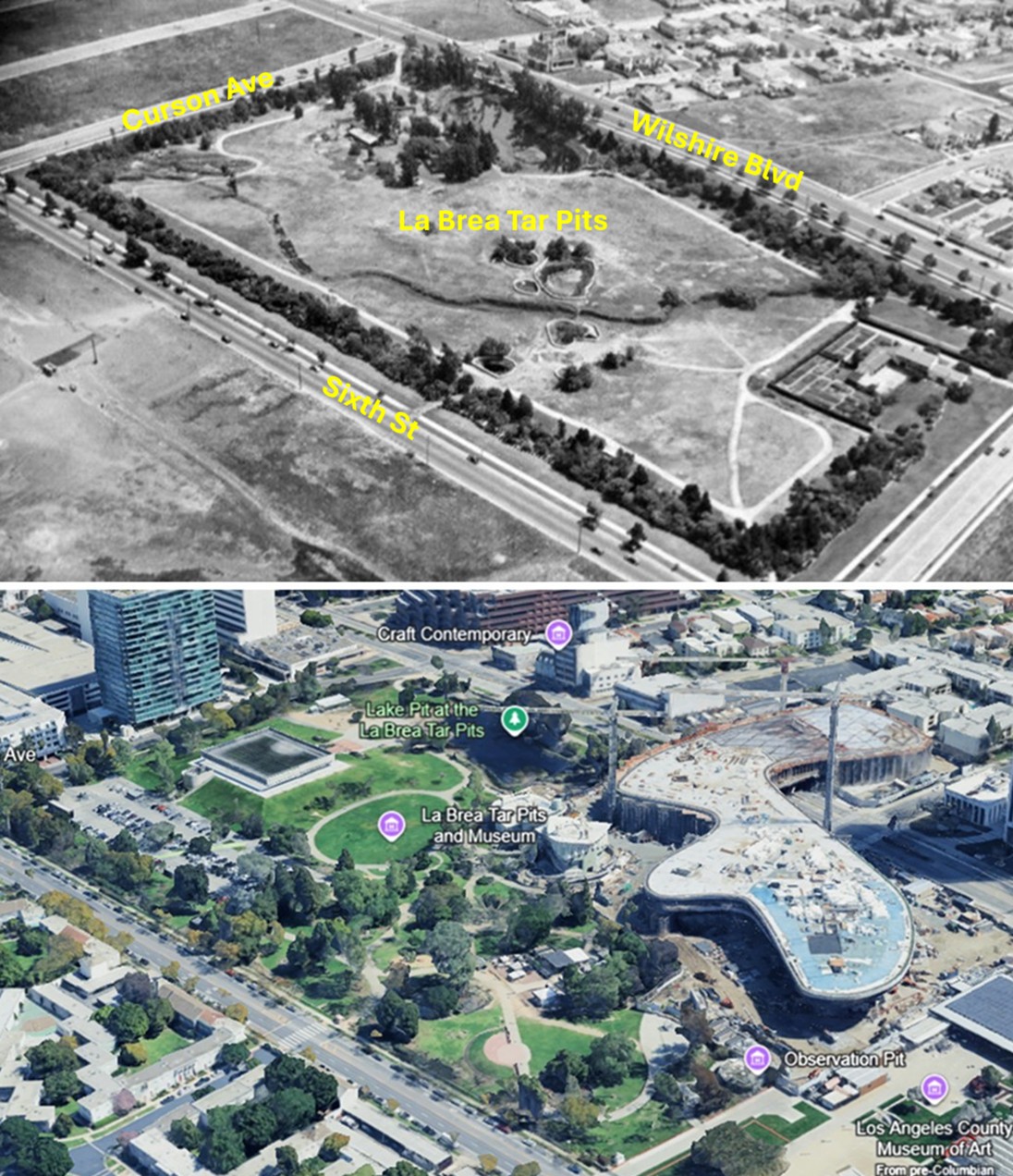
| (1924 vs 2023)* - A Then and Now comparison of the La Brea Tar Pits and surrounding district nearly one hundred years apart. Comparison by Jack Feldman. |
| Historical Notes
In 1924, the Salt Lake Oil Field was already declining. Wells were being abandoned, housing crept inward from the edges, and Wilshire Boulevard remained a narrow roadway cutting through an industrial landscape. By 2023, the same ground had become parkland and museum campus. The tar pits remain at the center, but oil derricks have given way to galleries, landscaped paths, and dense urban development along Wilshire. The comparison reveals both continuity and transformation. The park footprint survives, but its meaning has changed. Extraction defined the early landscape. Education, preservation, and culture define it today. |
From Oil Field to Urban District |
Arthur F. Gilmore played a pivotal role in this transformation. In 1901, while drilling for water on his dairy ranch near Fairfax and Third Street, he struck oil instead. The discovery helped fuel rapid expansion of the Salt Lake Oil Field and brought new wealth to the district.By the early 1920s, however, production began to decline. As Los Angeles pushed westward, land values rose and the economics of drilling gave way to development. Gilmore and others shifted their focus from extraction to real estate. Portions of former oil property were subdivided for housing, commercial ventures, and entertainment uses. The Farmers Market, later the Fairfax district, and much of the surrounding neighborhood stand on land that once supported derricks and pump jacks.The Hancock family followed a parallel path. While oil leases covered much of Rancho La Brea, the tar pits themselves were gradually recognized as scientifically significant. Fossil discoveries beginning in the early twentieth century attracted national attention. Instead of being fully absorbed by development, the tar pits were preserved as a public park and research site.By mid century, Wilshire Boulevard had emerged as a cultural spine. The opening of the Los Angeles County Museum of Art in 1965 anchored the district as a center for art and education. What began as a landscape of natural asphalt seeps and oil rigs became a corridor of museums, theaters, retail, and dense residential development.The oil economy did not vanish. It reshaped the land, generated capital, and then yielded to a different form of growth. Beneath the lawns of Hancock Park and the foundations along Wilshire, the petroleum field still exists. Above ground, its legacy is visible not in derricks, but in real estate, culture, and one of the most distinctive urban districts in Los Angeles. |
* * * * * |
Wilshire Before the Miracle Mile |
Circa 1910 to 1924 |
Before it became a commercial corridor, Wilshire Boulevard was a wide rural roadway cutting across oil fields and open land. The pavement was narrow, traffic was light, and development was sparse. Yet even in this early period, the boulevard was beginning to function as a motor route. Automobiles and motorcycles traveled west toward the edge of the city, sharing space with derricks, signboards, and scattered ranch structures.These images show Wilshire not as a destination, but as a passage — a transitional landscape poised between extraction and expansion. |
 |
|
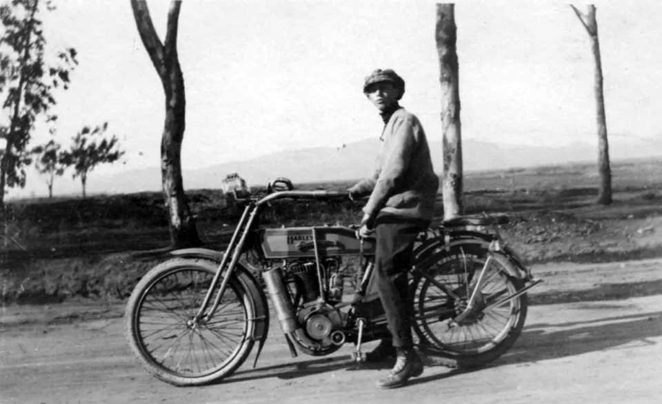
| (1910)* - View looking north showing a young man sitting on his Harley on Wilshire Boulevard with the Hollywood Hills in the distance. |
Historical Notes Around 1910, Wilshire Boulevard remained largely rural west of downtown. The paved roadway ran straight across open land toward the Hollywood Hills, passing oil leases and undeveloped fields. Traffic was light enough that a lone motorcyclist could stop in the roadway without obstruction. The presence of a motorcycle on Wilshire reflects the early embrace of motor transportation in Los Angeles. Even before large-scale commercial development, the boulevard was beginning to serve motorists traveling between the growing city and its western edge. This image captures Wilshire at a moment when mobility was modern, but the landscape was still frontier. |
 |
|
| (1920)* – View looking west toward la Brea Avenue on a two-lane Wilshire Boulevard. Signboards, open fields, and oil derricks are about all you can see. This would become part of the Miracle Mile. |
Historical Notes By 1920, Wilshire Boulevard had become a modest but visible motor route. The roadway remained narrow, bordered by open fields, oil derricks, and scattered advertising signs. Development was limited, and large stretches of frontage remained unbuilt. Despite its sparse surroundings, Wilshire’s width and straight alignment made it attractive for future expansion. The open land visible here would soon offer opportunities for subdivision and commercial construction as oil production declined and the city expanded westward. This image shows the boulevard as infrastructure — present, but not yet activated. |
 |
|
| (1922)* - Aerial view looking north towards the Hollywood Hills from above Wilshire Boulevard near La Brea. Oil wells are seen throughout the area. |
Historical Notes From the air, the scale of the Salt Lake Oil Field becomes clear. Wells spread across the flats, and housing appears only in isolated clusters. Wilshire Boulevard runs as a thin line through an industrial landscape that still dominates the district. The absence of dense construction reveals how much undeveloped frontage existed along Wilshire in the early 1920s. This openness would later prove critical to its transformation. When oil production declined, large parcels of land were available for reinvention. The boulevard’s future depended not only on vision, but on space — and space was abundant. |
|
|
| (1922)* - Aerial view looking northwest. Crescent Avenue, later renamed Fairfax Avenue, crosses Wilshire Boulevard and angles toward the Hollywood Hills. Oil derricks cover much of the open land. |
Historical Notes By 1922, this section of Wilshire was still dominated by the Salt Lake Oil Field. Derricks fill the flats, and the street grid is only beginning to take shape. Fairfax, then called Crescent Avenue, cuts north toward the hills while Wilshire runs thin and straight across an industrial landscape. The wide spacing of roads and the absence of tall construction reveal how easily this landscape could be reshaped once oil production declined. |
* * * * * |
Wilshire and Fairfax |
Oil Meets Aviation, 1919 to 1925 |
In the years just after the First World War, the oil fields at Wilshire and Fairfax briefly shared space with something unexpected. Aviation arrived. What had been open industrial land became a stage for exhibitions, drawing crowds, automobiles, and attention from across the growing city. For a short but memorable period, this industrial landscape functioned not merely as infrastructure, but as a destination.The presence of airplanes did more than entertain spectators. It proved that motorists were willing to travel west along Wilshire for events and attractions. Long before the Miracle Mile rose, the boulevard was already demonstrating its ability to draw sustained traffic and public attention. |
 |
|
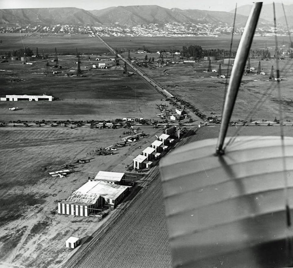
| (1920)* - Aerial view of Wilshire Boulevard and Crescent Avenue, later Fairfax Avenue. Oil derricks dominate the landscape. Chaplin Airfield is visible in the lower portion of the image. The diagonal rail alignment at the bottom later influenced the path of San Vicente Boulevard. |
Historical Notes By 1920, Wilshire and Fairfax remained largely undeveloped. Oil derricks filled the flats, and roads were still lightly traveled. Yet within this industrial setting, Chaplin Airfield began operating on leased land near the intersection. Syd Chaplin, half brother of actor Charlie Chaplin, promoted the field as a center for flying lessons, aircraft service, and public exhibitions. The airfield introduced a new layer of activity to a district still defined by extraction. From above, the contrast is striking. Airplanes share space with derricks. The land is open, highly visible, and accessible by road. These qualities would later become essential to the commercial identity of the Miracle Mile. |
 |
|
| (ca. 1922)* - View looking north near Wilshire and Crescent, later Fairfax. Automobiles fill a lot near the airfield and line the boulevard. A sign near the Pacific Electric line reads Albers Oats. |
Historical Notes This image reveals an important shift. While derricks still dominate the skyline, the foreground is filled with automobiles. Spectators drove out to attend flying exhibitions and air shows. Wilshire was no longer simply a service road for oil leases. It was becoming a destination. The open land provided clear views of the runway, and wide roadways allowed easy access. The growing presence of cars signaled that the district was beginning to function as a gathering place rather than an isolated industrial zone. |
 |
|
| (ca. 1922)* – View looking north over the wing of a biplane. The intersection of Wilshire and Fairfax is visible below, with oil derricks extending toward the foothills and early development appearing in the distance. |
Historical Notes From the air, the physical layout of the district becomes clear. Wilshire runs as a thin horizontal line across open ground. Fairfax cuts north toward the hills. The city appears distant and scattered. The airfield’s location at Wilshire and Fairfax exposed the intersection to repeated public gatherings, reinforcing its visibility and importance within the expanding city. What later became a dense commercial corridor was, in 1922, still largely open territory. The intersection’s repeated use for exhibitions gave Wilshire a public identity that extended beyond oil and industry. This image emphasizes the visibility of the Wilshire–Fairfax intersection within the oil field landscape. |
 |
|
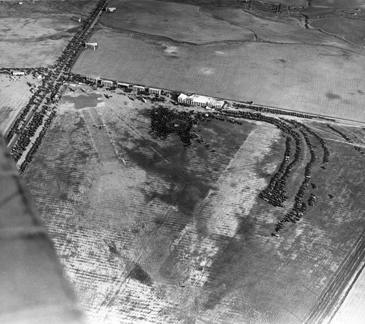
| (ca. 1922)* - View looking north over the wing of a biplane showing the intersection of Crescent Avenue, later Fairfax, and Wilshire Boulevard. A crowded airfield is visible below. Oil derricks rise across the horizon, and early Hollywood development appears at the foothills. |
Historical Notes If the earlier aerial view highlights geography, this one highlights momentum. The airfield below is active. Automobiles gather along the edges of the field. Spectators cluster near the runway. In a single frame, three eras overlap. Oil represents the first wave of land use. Aviation reflects experimentation and spectacle. The expanding city in the distance signals that westward growth is inevitable. This image captures transition. It suggests that the future Miracle Mile would rise on land that had already proven its ability to attract people and traffic. |
 |
|
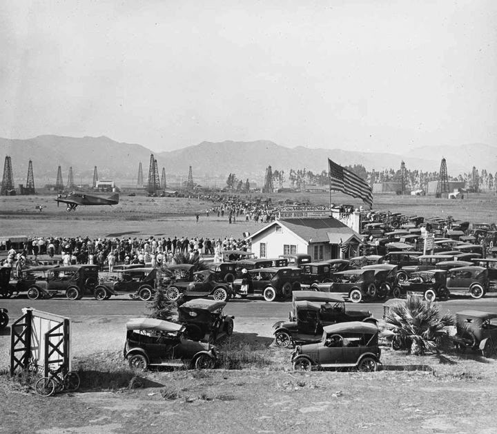
| (1920s)* - Spectators gather at DeMille Field near Wilshire and Crescent, later Fairfax. Automobiles fill the foreground as a plane taxis across the field. Oil derricks rise across the horizon. |
Historical Notes This photograph marks the high point of the aviation era at Wilshire and Fairfax. Crowds line the field, and rows of automobiles fill the open ground. The scene resembles a fairground more than an oil district. The size of the gathering is significant. In the early 1920s, Los Angeles was rapidly embracing the automobile. Wide roads and open frontage made this stretch of Wilshire easy to reach and easy to see. The air shows demonstrated that large numbers of people would travel west along Wilshire for a shared experience. The boulevard had proven its ability to draw sustained traffic and public attention. Within a few years, oil production declined and aviation activity moved elsewhere. What remained was a broad, highly visible boulevard already proven capable of drawing traffic. The crowds seen here were an early preview of the commercial energy that would define the Miracle Mile. |
The combination of open frontage, automobile traffic, and public attention had already demonstrated the commercial potential of Wilshire Boulevard. Within a few years, developers would begin transforming this former oil landscape into a new kind of retail corridor designed specifically for motorists. |
* * * * * |
A. W. Ross and the Auto Boulevard |
From Oil Lots to the Miracle Mile Idea, 1924 to 1930 |
By the mid 1920s, the aviation crowds that once gathered at Wilshire and Fairfax had faded, but they left behind an important lesson. People were willing to drive here. That realization would shape the next stage in the development of Mid Wilshire.At the same time, oil production in the Salt Lake Oil Field was beginning to decline. The derricks that had dominated the landscape for two decades were gradually becoming less profitable. Large open parcels remained along Wilshire Boulevard, and the rising city was beginning to push westward toward them.This was the moment when developer A. W. Ross began to imagine a different future for the boulevard. Instead of treating Wilshire as a rural service road passing through oil leases, Ross saw it as the perfect setting for a new kind of commercial district built specifically for the automobile.His idea was unusual for the time. Most shopping districts still depended on pedestrians and streetcar riders. Ross designed his corridor for motorists. Buildings would present bold architectural facades visible from moving cars. Parking would be placed behind the structures rather than in front, keeping the boulevard itself visually impressive. Wide intersections and clear sightlines would allow storefronts and signage to capture the attention of drivers.Several factors helped make this vision possible. Wilshire Boulevard was already a long, straight east west route through Los Angeles. Bus service operated along the boulevard, and the growing number of automobiles made it easier for shoppers to travel farther from downtown. Meanwhile, the fading oil industry left behind large open lots that could be redeveloped.The images that follow capture this transitional moment. Oil fields, empty land, and early commercial structures exist side by side. Within a few years these open parcels would be replaced by towers, department stores, theaters, and restaurants. What had once been an industrial landscape was beginning to transform into the automobile oriented commercial corridor that would soon be known as the Miracle Mile. |
 |
|
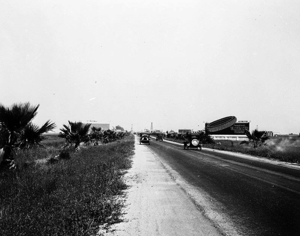
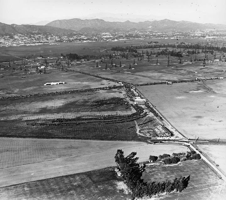
| (ca. 1929)* - View looking east on Wilshire Boulevard toward its intersection with Fairfax Avenue. The northeast corner with the billboard marks the future site of the May Company Department Store. On the opposite corner (northwest) the small white house stands on land once used for Rogers Airport, later the location of the famous circular Simon's Drive-in restaurant, today known as Johnie’s Coffee Shop. Oil wells are spread across the distance where Park La Brea would later rise. |
Historical Notes This photograph captures Wilshire Boulevard at the moment just before large scale commercial development began. Oil derricks still cover much of the landscape, and the boulevard itself remains relatively quiet. Yet several clues point toward the future. The wide roadway already serves as an important east west route for automobiles. Large undeveloped parcels occupy the corners, offering ideal sites for future construction. Developers were beginning to recognize the value of this open frontage. Within a decade the intersection of Wilshire and Fairfax would become one of the most recognizable locations on the Miracle Mile, anchored by the striking Streamline Moderne May Company building completed in 1940. The oil fields visible here would soon disappear beneath apartment towers, stores, and cultural institutions. |
 |
|
| (1930)* - View of an oil field at the northeast corner of Wilshire Boulevard and Curson Avenue. Click HERE for contemporary view. |
Historical Notes Even as plans for the Miracle Mile were forming, large sections of Wilshire Boulevard still looked like this. Oil wells and empty ground dominated the corners, while commercial development remained scattered. This corner illustrates the scale of land that developers were beginning to reshape. When oil production declined, these parcels became valuable real estate along one of the city’s most visible roadways. In 1948 the Prudential Building would rise on this site, replacing the oil field with a modern office tower. The change reflected the broader transformation of Wilshire Boulevard from industrial landscape to commercial corridor. |
 |
|
| (1930s)* - View looking northwest across Masselin Avenue on Wilshire Boulevard. A small sign near the right side of the image advertises available locations along the “Miracle Mile.” The La Brea Tar Pits can be seen in the distance. |
Historical Notes This photograph reveals an important turning point in the identity of Wilshire Boulevard. The name “Miracle Mile” was already being promoted even while much of the surrounding land remained undeveloped. Developers used advertising signs like the one visible here to attract retailers and investors to the new district. The term suggested a boulevard filled with modern architecture, fashionable shops, and convenient automobile access. Within a few years this stretch of Wilshire would become one of Los Angeles’ most distinctive commercial corridors. Department stores, theaters, restaurants, and office towers soon replaced the remaining oil fields. By the late 1930s the name “Miracle Mile” had become firmly associated with the 1.5 mile stretch of Wilshire Boulevard between Fairfax and Highland Avenues. Click HERE for a 1950 view of this same intersection. |
Then and Now
 |
|
| (1930 vs 2021)* - Northeast corner of Wilshire Boulevard and Curson Avenue. An oil field that once occupied the corner has been replaced by mid century and contemporary commercial development along the Miracle Mile. Photo comparison by Jack Feldman. |
Historical Notes In 1930 this corner of Wilshire Boulevard still belonged to the fading Salt Lake Oil Field. Derricks and pump equipment occupied the land, and large stretches of the boulevard remained undeveloped. Yet this empty frontage soon attracted the attention of developers who saw the potential of Wilshire as an automobile oriented commercial corridor. Less than two decades later the Prudential Building rose on this site in 1948, symbolizing the shift from oil production to office and commercial development. The transformation reflected a broader pattern along Wilshire Boulevard, where former drilling lots were gradually replaced by retail buildings, offices, and cultural institutions. Today the intersection sits firmly within the Miracle Mile district. The oil wells have long disappeared, but the wide boulevard and prominent corner still reflect the same advantage that first attracted developers: visibility along one of Los Angeles’ most important east west corridors. |
Then and Now
 |
|
| (1930 vs 2021)* - Looking northwest from Wilshire Boulevard across Masselin Avenue. What was once open land and early Miracle Mile promotion is now a dense urban corridor lined with commercial buildings, museums, and residential towers. Photo comparison by Jack Feldman. |
Historical Notes When the earlier photograph was taken in the early 1930s, the Miracle Mile was still more idea than reality. The sign visible near the right side of the image advertised available locations along Wilshire Boulevard, promoting the vision of a new automobile oriented shopping district. At the time, large portions of the surrounding land remained open or lightly developed. Oil wells still dotted the nearby landscape, and the La Brea Tar Pits were clearly visible in the distance. Over the following decades, Wilshire Boulevard filled in with department stores, theaters, offices, and cultural institutions. The Miracle Mile matured into one of Los Angeles’ most recognizable commercial districts. The modern view reveals how completely the landscape has changed. The empty parcels have been replaced by dense urban development, yet the boulevard itself continues to function much as A. W. Ross envisioned nearly a century ago: a prominent corridor designed to attract attention, activity, and movement across the city. |
* * * * * |
Wilshire and La Brea |
The First True Miracle Mile Intersection, 1928 to 1932 |
By the late 1920s the intersection of Wilshire Boulevard and La Brea Avenue was beginning to reveal the future of the Miracle Mile. Only a few years earlier the surrounding land had been filled with oil derricks belonging to the Salt Lake Oil Field. As drilling declined and Los Angeles continued expanding westward, the open parcels along Wilshire became valuable commercial property.Developer A. W. Ross promoted this stretch of Wilshire as a new kind of business district designed for motorists. Wide roadways, visible storefronts, and striking architecture would capture the attention of drivers moving along the boulevard. Wilshire and La Brea quickly became one of the first places where this vision could be seen taking shape.Banks, restaurants, service stations, theaters, and early office buildings appeared at the corners. Decorative streetlights were installed to give the boulevard a distinctive identity. Traffic increased as more Angelenos traveled the route by automobile and bus. Within only a few years this former oil field intersection had become one of the most active gateways to the emerging Miracle Mile.The images below capture this intersection during the years when that transformation was first becoming visible. |
 |
|
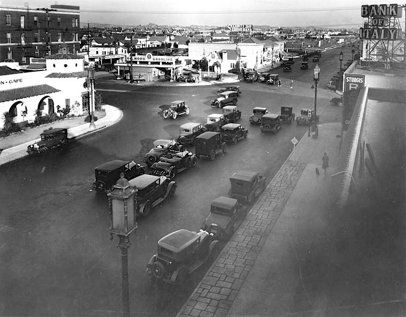
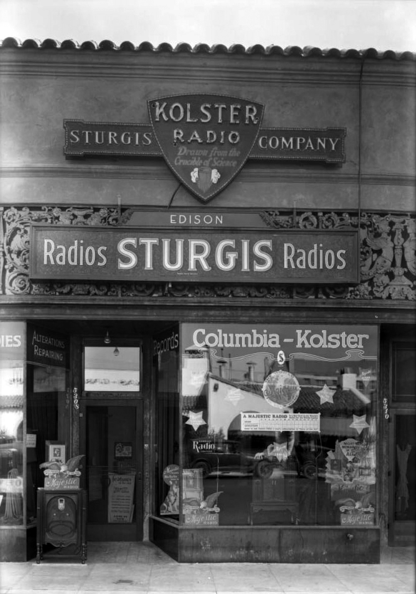
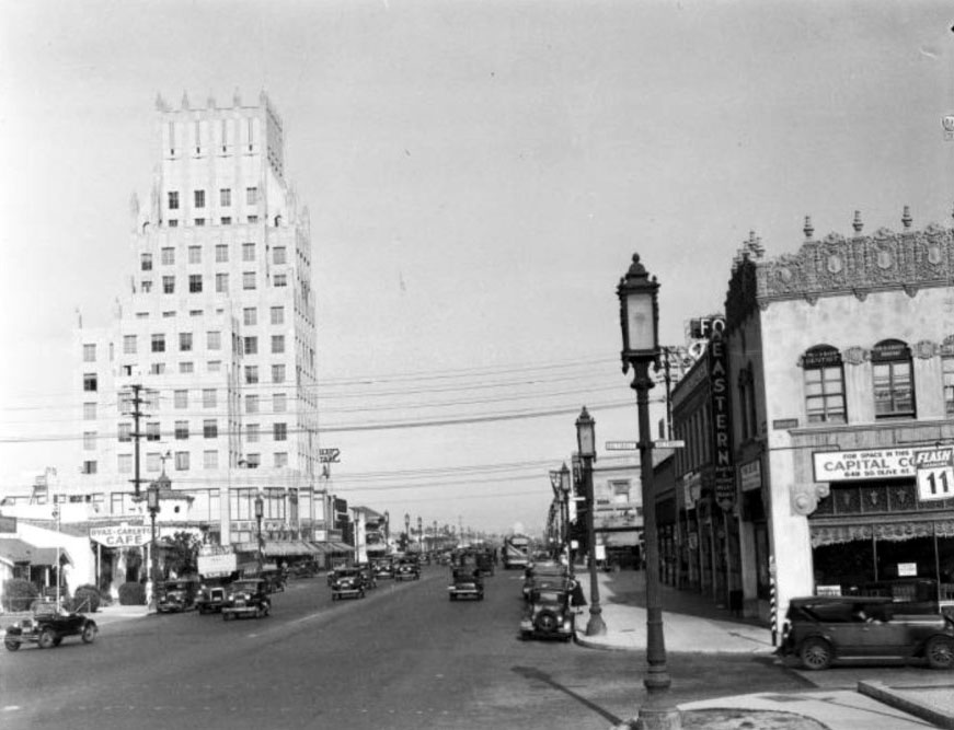
| (1928)* – View looking east on Wilshire Boulevard toward La Brea Avenue. Note the Gilmore gas station on the northeast corner; the following year it would be demolished to make way for the E. Clem Wilson Building. The white building at upper left is the Dyas-Carleton Café, built in 1928. The Bank of Italy (sign upper right corner) would become the Bank of America. Below that sign is another sign that reads: Sturgis Radio Store. |
Historical Notes This photograph shows Wilshire and La Brea just as the area was beginning to shift from oil production to commercial development. The Gilmore gas station on the northeast corner served motorists traveling along Wilshire, which was rapidly becoming one of the city’s most important automobile routes. Across the street the Bank of Italy had opened a branch office, reflecting growing confidence in the future of the district. Restaurants such as the Dyas Carleton Café provided gathering places for drivers, nearby workers, and residents of the growing neighborhoods around the boulevard. Signs for businesses like the Sturgis Radio Store hint at the modern technologies of the era. In the late 1920s radio was transforming how people received news and entertainment. Shops like this helped introduce the new medium to households throughout Los Angeles. Only a short time earlier this entire intersection had been surrounded by oil wells. The businesses visible here show how quickly the landscape was changing. |
 |
|
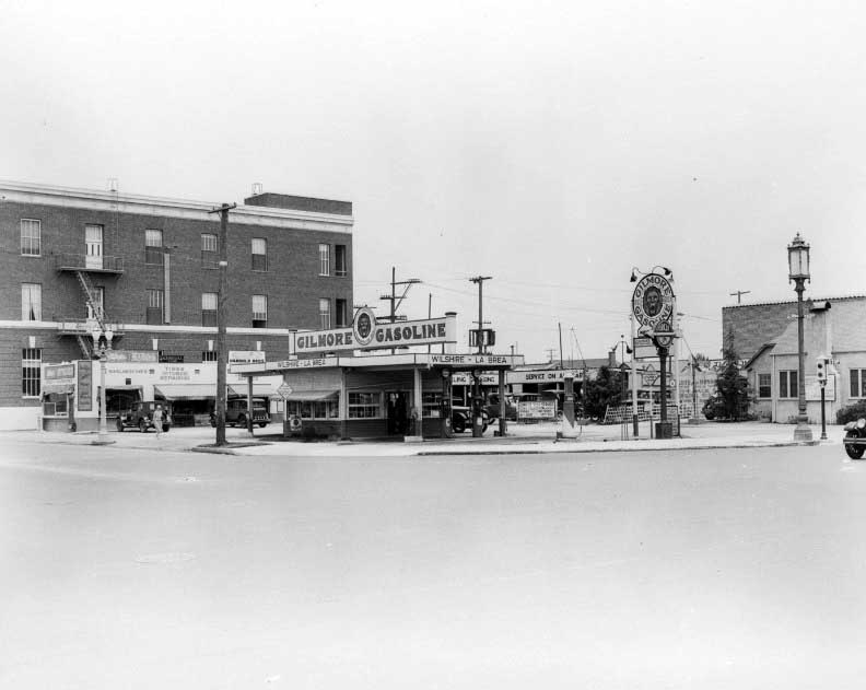
| (1928)* – View of the Gilmore gas station on the northeast corner of Wilshire Boulevard and La Brea Avenue. The brick building on the left is the telephone switching center. |
Historical Notes The Gilmore gas station stood at a corner that had once been surrounded by oil drilling associated with the Salt Lake Oil Field. The field covered much of the land between La Brea and Fairfax during the early twentieth century. In 1901 Arthur F. Gilmore struck oil while drilling for water on his nearby dairy ranch west of Fairfax Avenue, helping launch development of the field that soon spread across the surrounding area. By the late 1920s the automobile had become central to daily life in Los Angeles. Service stations like this one were among the first businesses to appear along Wilshire Boulevard as the road developed into a major motor route. Behind the station stands the Southern California Telephone Company switching center, completed in 1925. The building handled telephone connections for the rapidly growing western neighborhoods of Los Angeles. Reliable telephone service was becoming essential as offices, stores, and restaurants began moving into the district. In 1929 the gas station was demolished to make way for the E. Clem Wilson Building, one of the earliest office towers on the Miracle Mile. |
 |
|
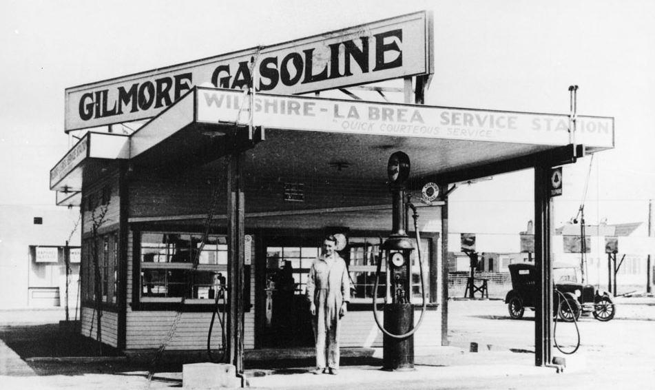
| (1920s)* - The Gilmore Gas Station was one of the first gas stations in Los Angeles. Located at the corner of La Brea and Wilshire Blvd. |
Historical Notes Gasoline stations were a natural early presence along Wilshire Boulevard. As more Angelenos purchased automobiles during the 1920s, service stations provided fuel, repairs, and roadside assistance for drivers traveling between downtown Los Angeles and the city’s expanding western neighborhoods. The Gilmore company became one of Southern California’s best known petroleum brands. Its stations and the company’s red lion emblem were familiar sights throughout the region. A reminder of that history still exists nearby today. A replica of a 1930s era Gilmore gas station stands at the Farmers Market at Third Street and Fairfax Avenue. Installed during construction of The Grove in 2002, the replica commemorates the oil and automobile heritage of the district. Click HERE to see more Early Views of LA Gas Stations. |
.jpg) |
|
| (ca. 1929)^ - Looking west along Wilshire Boulevard at La Brea Avenue. The Ritz Theatre is on the left; on the right the Security-First National Bank Building (the first Art Deco structure on the Miracle Mile) is under construction. The The E. Clem Wilson Building (1930 - N/E corner of La Brea and Wilshire) has yet to be constructed. On the N/W corner can be seen the Dyas-Carleton Café. |
Historical Notes By 1929 Wilshire and La Brea had become one of the most active intersections along the developing Miracle Mile. The construction of the Security First National Bank building signaled that major financial institutions were beginning to invest in the district. Banks often served as anchors for new commercial areas because they projected stability and confidence. The striking Art Deco design of the bank building also reflected the modern architectural style that would soon characterize much of the Miracle Mile. Across the street the Ritz Theatre drew visitors to the area for evening entertainment. Restaurants and cafés nearby served the growing crowds. Together these businesses helped transform Wilshire Boulevard from a simple roadway into a destination. |
* * * * * |
Sturgis Radio Store |
 |
|
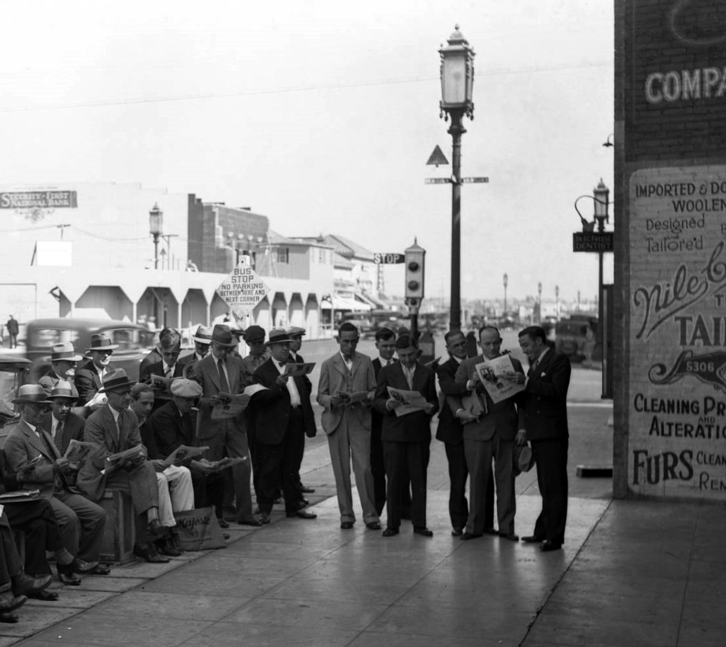
| (1929)* - A large group of men, most of whom are reading newspapers, are seen sitting and standing near the SW corner of Wilshire and La Brea. It turns out they are also listening to a live radio broadcast of the World Series in front of Sturgis Radio Store located to the right (out of view). Across the street on the NE corner can be seen the construction site for the new E. Clem Wilson Building where the Gilmore Gas Station once stood. The Art-Deco Security-First National Bank Building sits just to the east of there. Note the "Wilshire Special" streetlights and the Semaphore traffic signal on the corner. |
Historical Notes At this time, television was not yet available in homes, so radio served as the primary way families and communities shared news and entertainment. Crowds often gathered in public to listen together, creating a powerful sense of community. In the background, the northeast corner shows the construction of the E. Clem Wilson Building, which replaced the Gilmore Gas Station. To its east stood the Art-Deco Security-First National Bank Building. Also visible are “Wilshire Special” streetlights—ornate bronze posts installed in 1928, topped with lanterns guarded by four stylized, bare-breasted female figures—that became symbols of Wilshire Boulevard’s elegance. An early Semaphore traffic signal stands at the corner, reflecting the city’s first experiments in traffic management. This location is today the site of the Wilshire/La Brea Purple Line Metro station, scheduled to open in 2025. The northeast corner, once just a construction site, is now part of the commercial development that defines Los Angeles’ historic Miracle Mile. Click HERE for contemporary view. |
 |
|
| (1929)* - The crowd gathers outside the Sturgis Radio Store, listening intently to the live broadcast—many with newspapers in hand. |
Historical Notes The Athletics won the series in five games, highlighted by a dramatic Game 4 comeback when they scored 10 runs in the seventh inning after trailing 8-0. For fans, radio made it possible to experience this drama in real time. The moment demonstrates the cultural significance of radio in the 1920s. Televised sports were still years away—the first official Major League night game would not be played until 1935, and baseball itself would not arrive on the West Coast until 1958 when the Dodgers and Giants relocated. In 1929, radio was not just technology, but a social glue that brought neighbors and strangers together to share unforgettable experiences. |
 |
|
| (1929)* - Close-up view showing the front entrance to the Sturgis Radio Store at 5308 Wilshire Boulevard. A sign reads: “A Majestic Radio is a Box Seat to the World’s Series for the Whole Family, Cubs, Athletics, Come in and receive Free a year’s subscription to ‘Voice of the Air’. |
Historical Notes This marketing campaign reveals how radios were pitched not simply as gadgets, but as gateways to culture and entertainment. They promised families a way to enjoy major national events like the World Series from the comfort of their living rooms—something revolutionary in an era before television. The sign also reflects how businesses tied their promotions to current events, offering radios as both technological marvels and tools of togetherness. For many households, the purchase of a radio meant joining in a new, shared national culture built on sound waves. |
* * * * * |
Wilshire and La Brea |
 |
|
| (ca. 1929)^*# - View looking east along the Miracle Mile. The prominent brick structure (center-left) is the telephone switching center still is existence on La Brea Avenue just north of Wilshire. |
 |
|
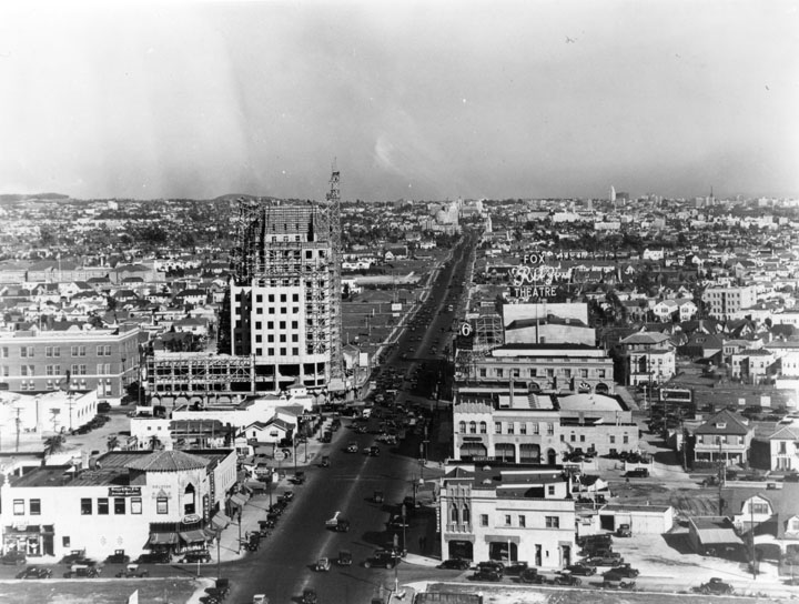
| (1930)* - View looking east on Wilshire Boulevard as seen from the top of the newly built Dominguez-Wilshire Building, between Cochran and Cloverdale Avenues. The E. Clem Wilson Building can be seen on the N/E corner of Wilshire and La Brea and appears to still be under construction. |
 |
|
| (1930)^ - Wilshire Boulevard looking east from Tower Building west of La Brea in 1930. The Ritz Theatre is visible on the right. The new high rise E. Clem Wilson Building on the northeast corner of La Brea and Wilshire is under construction. |
 |
|
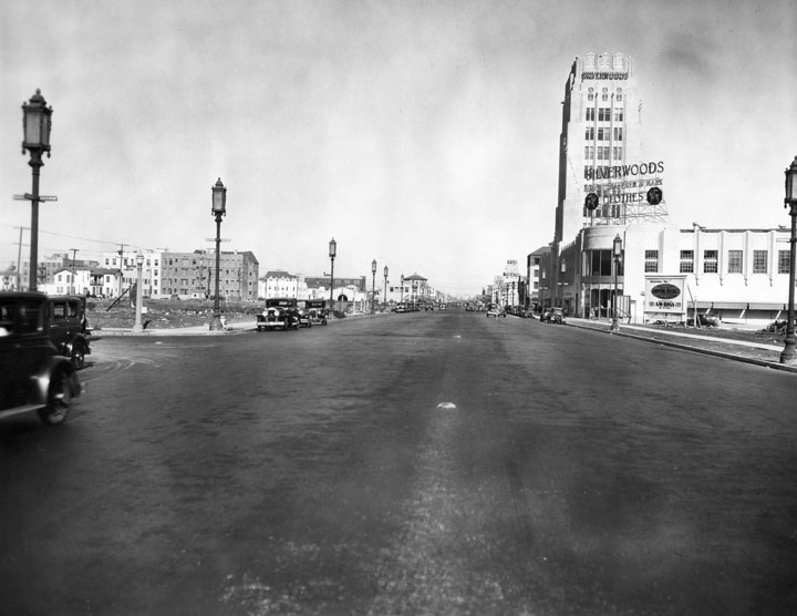
| (1932)* – View looking east on Wilshire Boulevard from Detroit Street. Ornate streetlight lanterns called “Wilshire Specials” line both sides of boulevard. The E. Clem Wilson Building is seen in the distance. |
E. Clem Wilson Building |
 |
|
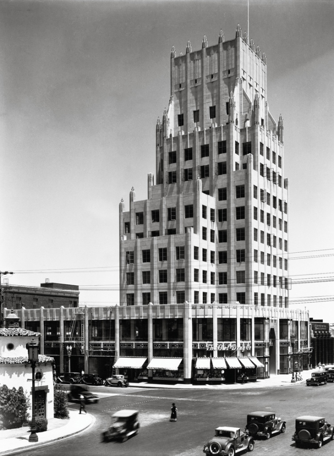
| (ca. 1930)*^^ - View of the intersection of Wilshire and La Brea. The new E. Clem Wilson Building is seen standing on the northeast corner. An Owl Drug store occupies the ground floor on the corner. |
Historical Notes Built in 1929 - 1930, the E. Clem Wilson Building was designed by architects Meyer and Holler in Art Deco (Zigzag) Moderne style. It is also known as the Wilson Building. Corporate names that adorned the Wilson Building included (in chronological order): General Insurance, Mutural of Omaha (until 1990), Asashi, and Samsung. |
 |
|
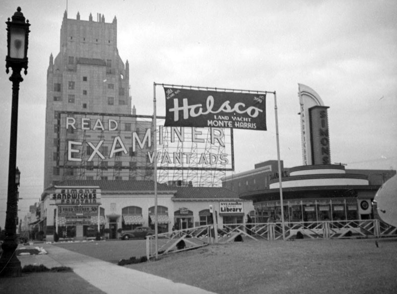
| (ca. 1939)^ - View showing the Simon’s drive-in restaurant, located at 5171 Wilshire Boulevard, with a sign for Halsco out front on the lawn. Nearby are a sign which encourages passers-by to “Read Examiner Want Ads,” the offices for Mutual of Omaha in the E. Clem Wilson Building (upper left, later Samsung), located at 5217 Wilshire Boulevard, and two Wilshire Lanterns (left). |
Historical Notes At one time Simon's Drive-Ins dominated the Southern California drive-in restaurant craze. The Simon brothers had operated a chain of successful dairy lunch counters in downtown Los Angeles, and in 1935 decided to capitalize on the growing car culture of Los Angeles by opening auto friendly locations in the emerging commercial centers of Wilshire Boulevard, Sunset and Ventura Boulevards. Click HERE to see more Early Views of LA Drive-in Restaurants. |
Fox Ritz Theatre |
 |
|
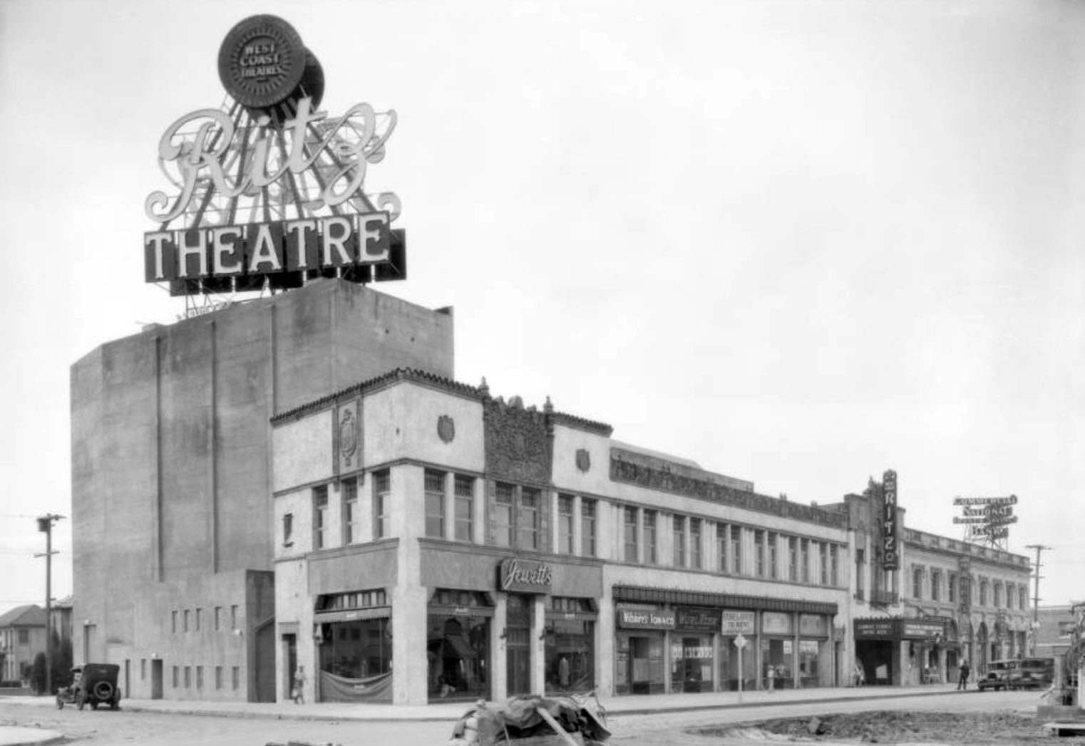
| (1926)^ – View looking at the southwest corner of Wilshire and Sycamore showing the Ritz Theatre. Opened in 1926, it joined the Fox theatre chain soon thereafter. The theatre building was on the south side of Wilshire and occupied the block between La Brea and Sycamore. |
Historical Notes The Fox Ritz Theatre at 5214 Wilshire Boulevard (S/E corner of Wilshire and La Brea) was designed by architect Lewis A. Smith. The 1600-seat theatre opened in 1926 and was demolished in 1977. |
 |
|
| (1931)^ – View showing the intersection of Wilshire Boulevard and La Brea Avenue with the Fox Ritz Theatre on the southeast corner. Note the double-decker bus on the left. |
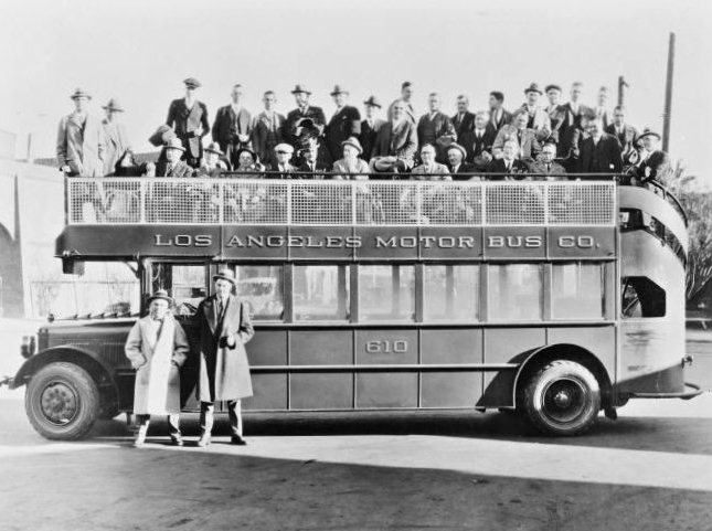
Los Angeles Motor Bus Co. |
 |
|
| (ca. 1920s)^## - This double-decker bus no. 610 was part of the Los Angeles Motor Bus line, built by Fageol in 1924. |
Historical Notes Los Angeles Motor Bus (later renamed the Los Angeles Motor Coach Company) was a joint venture of Pacific Electric and Los Angeles Railway that existed from 1923 until 1949. It began in 1923 as Wilshire Boulevard's transit service from the MacArthur Park area to La Brea Avenue and was extended further down Wilshire as the service gained in popularity. Wilshire has an interesting distinction, it was the only street that was banned by the City of Los Angeles from having street rail on it. The elites of early 20th century Los Angeles who built their mansions in the area were the region's first "NIMFYs" (Not in My Front Yard). The clanging bells and masses who rode streetcars were not welcomed on Wilshire, but buses were. |
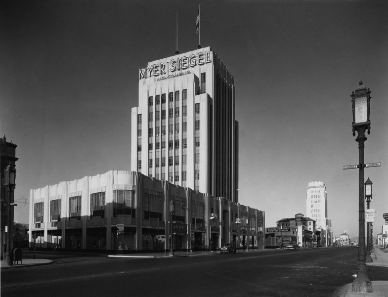
Dominguez-Wilshire Bldg. (aka Myer Siegel Bldg.) |
 |
|
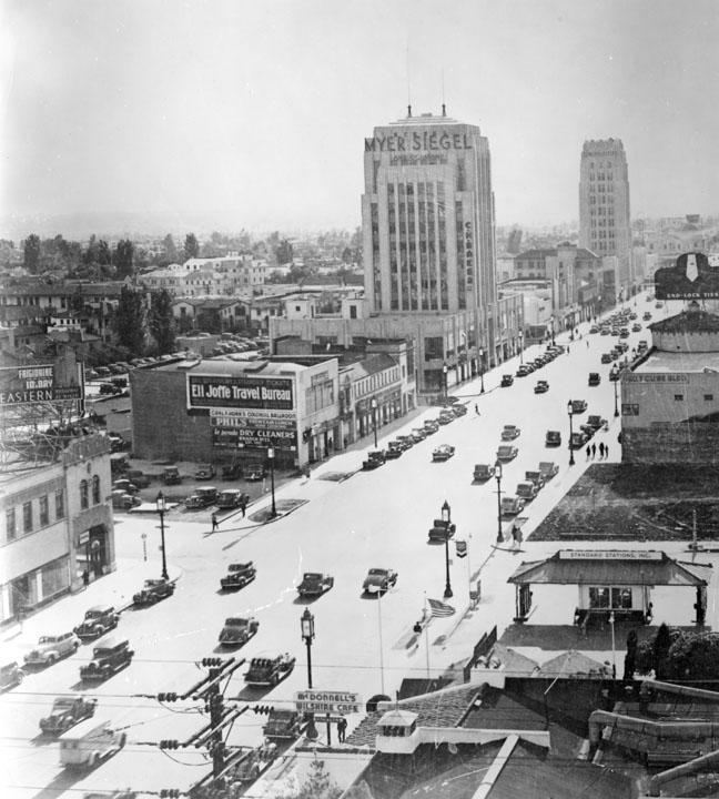
| (1932)^ - An overview of Wilshire Boulevard, looking west. Visible on the left side of the picture is a high rise building labeled Myer Siegel and Company (the Dominguez Building) with C.H. Baker on the front right lower portion of the exterior. Farther back on the street is Wilshire Tower with the name Desmonds just visible on the top. On the right side near the bottom of the picture is McDonnell's Wilshire Cafe and past it a Standard Oil gas station. |
Historical Notes The Dominguez-Wilshire building (also called the Myer-Siegel Building) was designed in 1930 by architects Morgan Walls and Clemens. The property was named after its developers, the Dominguez family, the heirs to the first land grant given in California by King Carlos III of Spain. |
 |
|
| (1931)^*# - Exterior view of the Dominguez-Wilshire Building (also known as the Myer Siegel Building), located at 5410 Wilshire Boulevard in the Miracle Mile district. The Wilshire Tower Building can be seen in the background. |
 |
|
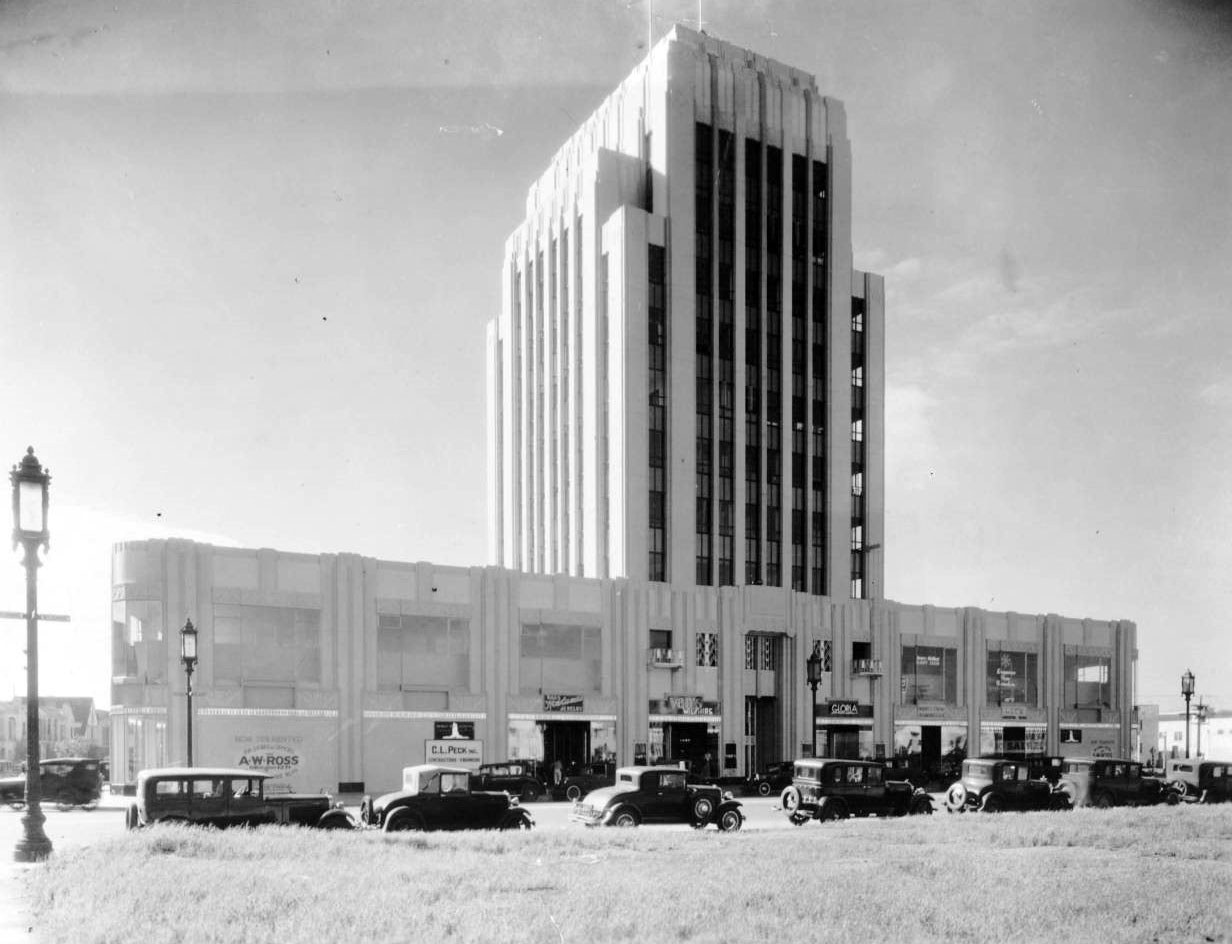
| (1931)^^ – View showing the Dominguez Wilshire Building, 5410 Wilshire Boulevard, shortly after opening as seen from an empty lot across the street. ; photograph dated 1931. Signs on the street level facade identify the leasing agent as A. W. Ross (the creator of the Miracle Mile). The signs also tout that the building is 75% rented. |
Historical Notes The same setup was used in the Wilshire Tower, two blocks west, with the symmetrical facade facing Wilshire Blvd, rounded corners on the intersections, and a parking lot with an entrance around the back. The 10 stories don't rise as high as the Wilshire Tower, but the building does make a statement among the other low rises along Wilshire Boulevard. |
 |
|
| (1930s)^*# - View looking at the SE corner of Wilshire Boulevard and Cochran Avenue showing the Dominguez Wilshire Builidng. Click HERE to see contemporary view. |
Historical Notes Zigzag motifs and a main automobile entrance at the rear defined this Art Deco office tower, the second built on the Miracle Mile after the Wilshire Tower (Gilbert Stanley Underwood, 1929) at 5514 Wilshire. The building's lower floors were leased by Myer Siegel, a women's clothing store known for showing the latest fashions from Paris. |
 |
|
| (1931)^*# - Rear view of the Dominguez-Wilshire Building (Myer Siegel Building) from across Cloverdale Avenue with a partial view of the parking lot and the rear entrance. |
Historical Notes The building consists of an eight-story Art Deco tower placed on a two-story base. |
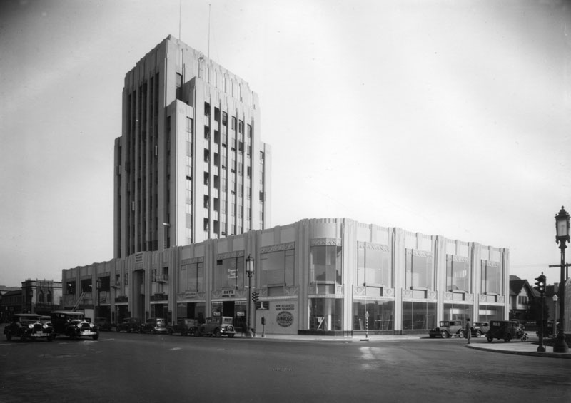
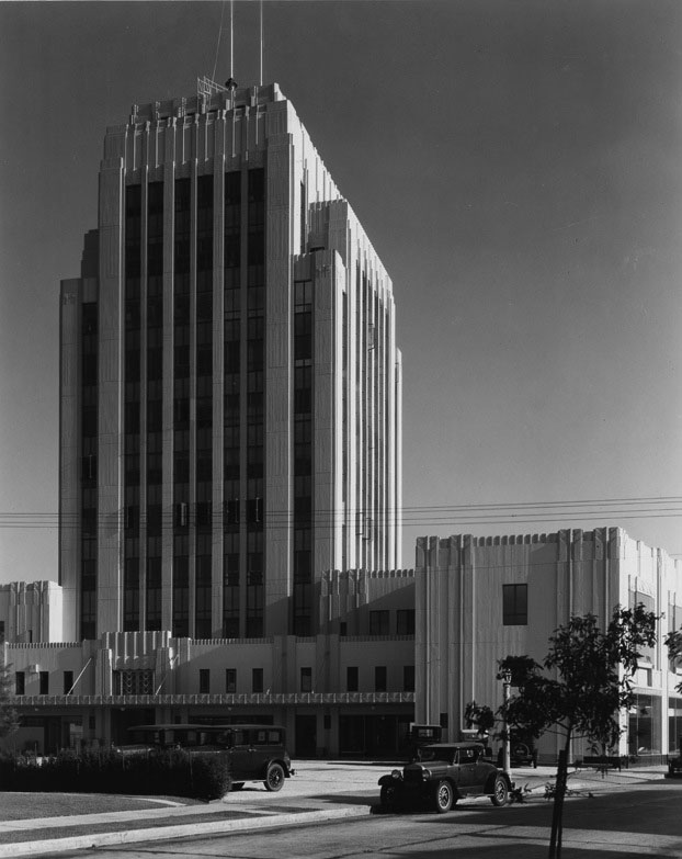
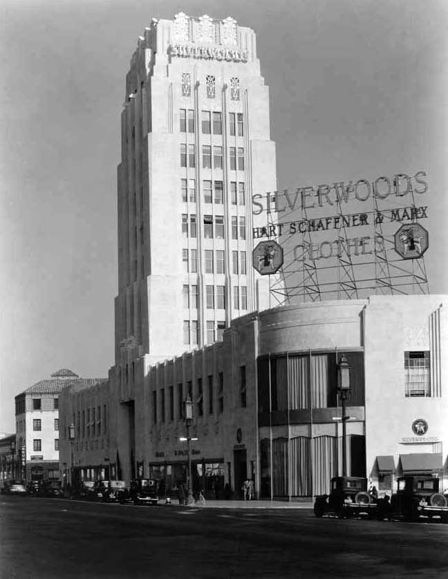
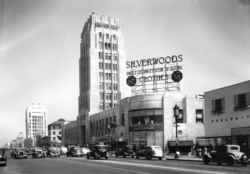
Wilshire Tower (aka Desmonds Building) |
 |
|
| (1929)^^ – View looking south along an unpaved Burnside Avenue at the Wilshire Tower on Wilshire Blvd. |
Historical Notes When it opened on March 15, 1929, the Wilshire Tower fronted an entire city block and featured an 11-story Art Deco tower. Desmond's main entrance opened onto the sidewalk, but many shoppers entered through the rear; in a nod to the automobile's ascendency, the store's owners built a large parking lot behind the store and reserved additional space for future parking needs. Other retailers soon followed Desmond's to the Miracle Mile, and they, too, provided ample parking for their customers behind their buildings. Silverwood's arrived in September 1929. |
 |
|
| (1929)^ - View looking southwest showing Desmond's Clothing Store in the Wilshire Tower on the Miracle Mile, 5514 Wilshire Blvd. |
 |
|
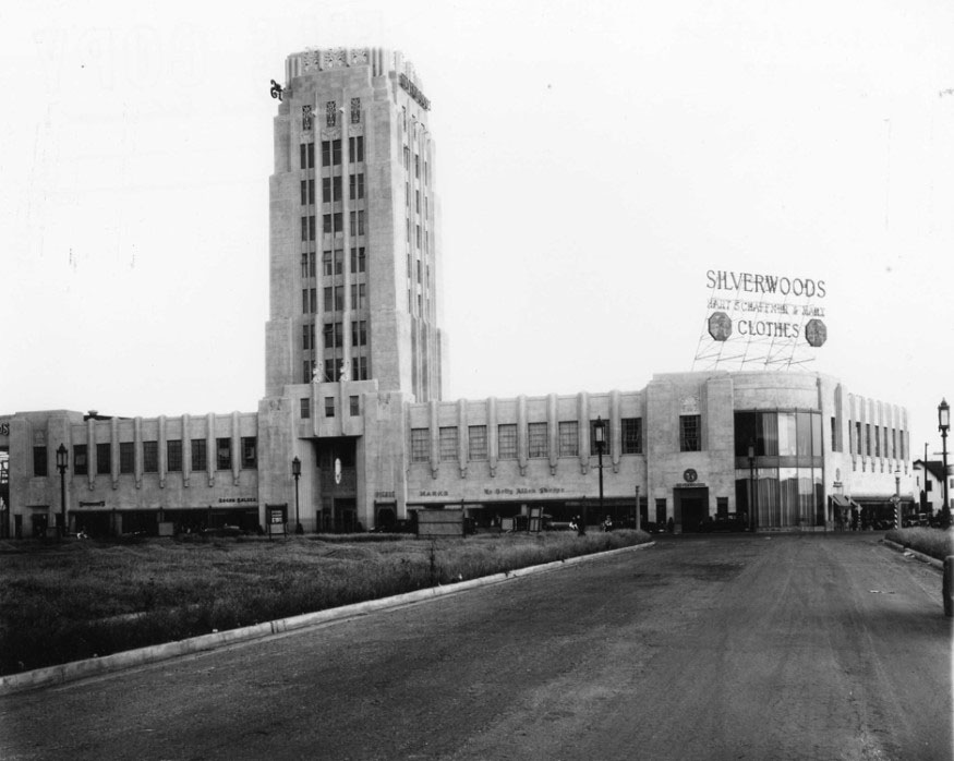
| (1929)* - Ridgeley Drive and Wilshire Boulevard, showing the Wilshire Tower with Silverwoods on the ground floor. |
Historical Notes Wilshire Tower was the first Art Deco landmark tower on the street. Over the years stores such as Desmond's and Silverwoods occupied the ground floor while doctors and dentists had offices in the eight-story tower. Located at 5514 Wilshire Boulevard, the Zig-Zag Moderne building was designed by architect Gilbert Stanley Underwood and built in 1928.^ Note the ornate streetlights on Wilshire Boulevard, often referred to as 'Wilshire Specials'. |
Then and Now
 |
|
| (1929 vs 2022)* - Looking east on Wilshire from near Ridgely Drive. Photo comparison by Jack Feldman. |
 |
|
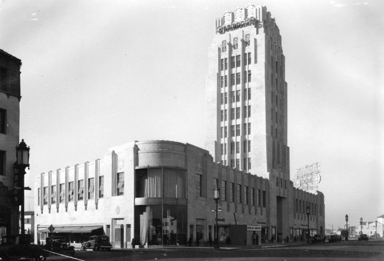
| (ca. 1930)^*# - Close-up view of the Wilshire Tower Building. The Silverwood's sign uppears both on the face of the top of the tower as well as on the roof of the store on the southeast corner of Wilshire and Burnside. |
Historical Notes Silverwood's was founded in 1894 by Francis Bernard ("Daddy") Silverwood, Los Angeles clothier, merchant, and businessman, originally from Canada, near Lindsay, Ontario. The first store was located at 124 South Spring St. in Los Angeles, and soon moved to larger quarters at 221 South Spring St. The flagship store was established in 1904 at Sixth & Broadway in downtown Los Angeles. Hartmarx, one of the nation's largest clothing manufacturers and retailers, bought Silverwood's in 1941 and kept thee name. The Silverwood's chain of clothing stores folded in the 1990s. |
 |
|
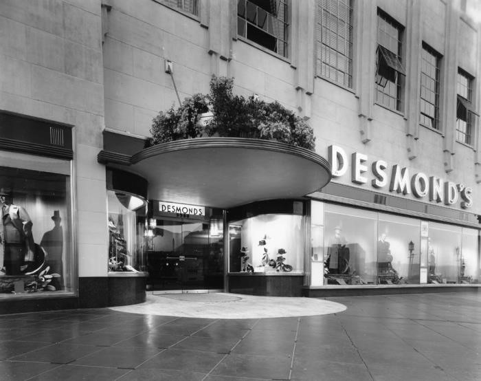
| (ca. 1939)+^^ – View showing the entrance to the Desmond’s store located in the Wilshire Tower Building. Note the huge window displays. |
Historical Notes Desmond’s was the first major clothing retailer on the Miracle Mile when it opened in 1929. Its main entrance opened onto the sidewalk, but many shoppers entered through the rear; in a nod to the automobile's ascendency, the store's owners built a large parking lot behind the store and reserved additional space for future parking needs. The first Desmond's Department Store was opened on Olvera Street in 1862. In 1921, Ralph R. Huesman purchased the store from the Desmond family and led the expansion of the retailer to several locations throughout the Southern California market. |
Historical Notes The historic Art Deco Wilshire Tower was designed by architect Gilbert Stanley Underwood and built in 1928-1929. It is a Zig-Zag Moderne two-story building with an eight-story office tower. Click HERE for contemporary view. |
Phelps-Terkel Department Store |
 |
|
| (ca. 1936)* - View looking at the SW corner of Wilshire Blvd and Burnside Ave showing the Phelps-Terkel Department Store building. |
Historical Notes Founded in 1923 by Richard B. Terkel and David S. Phelps, Phelps-Terkel was a Los Angeles based department store specializing in men’s clothing. |
.jpg) |
|
| (ca. 1936)* - Close-up view showing the front entrance to the Phelps-Terkel store, 5550 Wilshire at Burnside Avenue. |
Historical Notes In 1965 Phelps-Terkel became part of the Phelps-Wilger chain, based in Westwood; together the new chain had store in: the Miracle Mile, Pasadena, Westwood (2), Sherman Oaks, Newport Beach. Tom Selleck was once a sales clerk at the Sherman Oaks store. In its final years, Phelps-Meager was renamed Phelps, and closed in 1992.*^ The 1936-built Phelps-Terkel department store, designed by Morgan, Walls, and Clements, stood until 2006 when it was demolished to make way for a massive housing complex. |
* * * * * |
 |
|
| (1930s)*# – View looking at the northwest corner of Wilshire Boulevard and Ridgeley Drive. The Ralph’s Market can be seen further west on Wilshire. Click HERE for contemporary view. |
Ralphs Market |
 |
|
| (1928)* – View showing Ralphs Market on the NE corner Wilshire and Hauser soon after it opened for business. Note the oil derrick in the distance on the left. |
Historical Notes When the Miracle Mile Ralphs Market was constructed, the neighborhood was full of fallow fields and oil derricks. Clements' design integrated separate commercial spaces into the grocery building for rental tenants, heralding a promising future for the area while giving Ralphs another source of income. |
 |
|
| (1932)* – View looking northeast on Wilshire toward Hauser showing Ralphs Market on the right with a new Pig’n Whistle sign on top of the building. Western Auto Supply Co. Building can be seen in the distance on the NW corner of Wilshire and Hauser. Click HERE for contemporary view. |
Historical Notes At the time, all the new Ralphs stores were built in the Churrigueresque style popular in Southern California, an ornate Spanish Revival style that architect Stiles O. Clements defined and perfected. Each of the new Ralphs was unique yet similar, exuding strength through large blocks of faux masonry, intricate wrought ironwork, prominent display windows, and Spanish tile roofs. The Pig’n Whistle was there from 1929 to 1938, when the Pig’n Whistle company opened its new upscale restaurant, Melody Lane, at Detroit and Wilshire. |
Western Auto Supply Co. Building |
 |
|
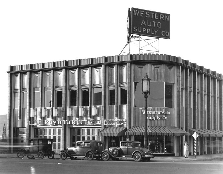
| (1930s)**#* - View of the Western Auto Parts store at the northwest corner of Wilshire and Hauser Blvds. |
Historical Notes The Western Auto Parts store was designed by Carl Lindbom and completed in 1931. It is the current location of a IHOP restaurant. Click HERE for contemporary view. |
 |
|
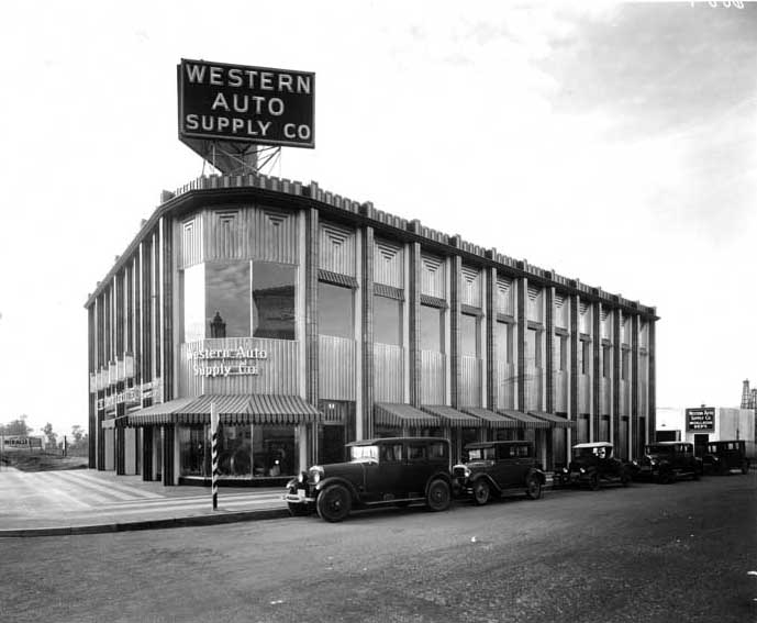
| (1930s)^*# - View of the northwest corner of Wilshire and Hauser showing the Western Auto Supply Co. Building. Several cars are seen parked on Hauser Blvd. |
Historical Notes In 1909, at the age of twenty-three, George Pepperdine started Western Auto Supply Company in Kansas City, Missouri, with an initial investment of five dollars. With the rise in popularity of the automobile, Pepperdine's business thrived, providing high-quality automotive products and services through many retail stores. He moved to California in 1916 where he became extremely successful as his business continued to grow. In 1937, during the Great Depression, he founded Pepperdine University as a Christian liberal arts college in South Los Angeles. The school expanded to Malibu in 1972. |
 |
|
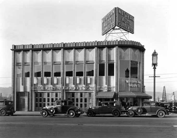
| (1930s)^*# - View looking north of the Western Auto Supply Co. Building located at 5655 Wilshire Boulevard. A tall "Wilshire Special" streetlight stands on the corner (Wilshire and Hauser). In the distance also stands an oil derrick. Click HERE to see more Early L.A. Streetlights. |
Then and Now
 |
|
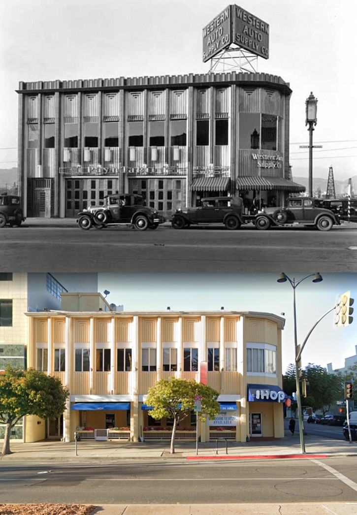
| (1931 vs. 2021)* - Western Auto Supply Co. Building, currently an International House of Pancakes (IHOP) restaurant. Photo comparison by Jack Feldman. |
* * * * * |
Wilshire and Fairfax |
|
|
| (ca. 1929)* - View looking east on Wilshire Boulevard toward its intersection with Fairfax Avenue. The northeast corner with the billboard is where the May Company Department Store would go about 10 years later. On the opposite corner (NW corner) where the little white house is, was once Rogers Airport, and would later become the iconic circular Simon's Drive-in restaurant. It is now the Johnies 50s diner. Oil wells are spread out where Park La Brea is now. |
Historical Notes In the late 1930s the 1.5-mile stretch of Wilshire Boulevard between Fairfax and Highland Avenues would be named the Miracle Mile. |
 |
|
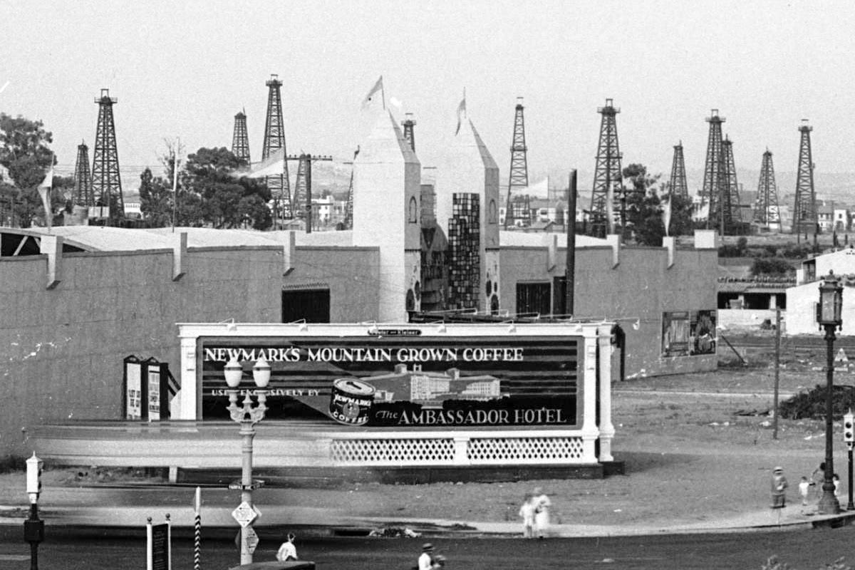
| (ca. 1929)* – Close-up view of the northeast corner of Wilshire and Fairfax with an unusual shaped building located at the future site of the May Company Building. Signboard in the foreground reads “Newmark’s Mountain Grown Coffee Exclusively Served by the Ambassador Hotel”. Note all the oil derricks in the background. |
Historical Notes In the 1890s, dairy farmer Arthur F. Gilmore found oil on his land, probably in the vicinity of the La Brea Tar Pits. The field was named after the Salt Lake Oil Company, the first firm to arrive to drill in the area. The discovery well was spudded (started) in 1902. Development of the field was fast, as oil wells spread across the landscape, with drillers hoping to match the production boom taking place a few miles to the east at the Los Angeles City field. Peak production was in 1908. By 1912, there were 326 wells, 47 of which had already been abandoned, and by 1917 more than 450, which had by then produced more than 50 million barrels of oil. After this peak, production declined rapidly. Land values rose, corresponding to the fast growth of the adjacent city of Los Angeles, and the field was mostly idled in favor of housing and commercial development. The early wells were abandoned; many of their exact locations are not known, and are now covered with buildings and roads. |
 |
|
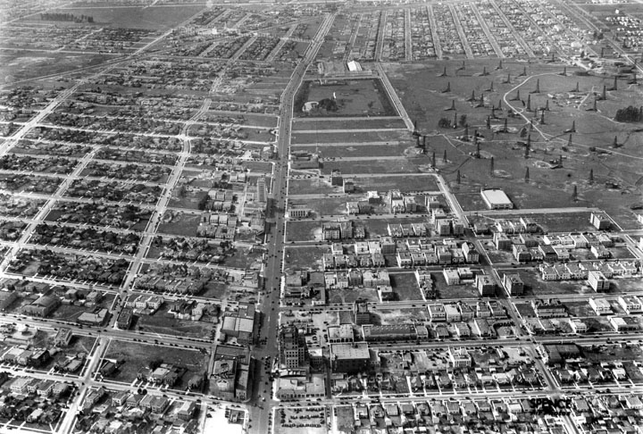
| (1930)^ - Aerial view looking west down Wilshire Boulevard from above Sycamore. The widest street visible, Wilshire, became known as the Miracle Mile, where most high rises were built through the years. The Salt Lake Oil Field is at upper-right and the La Brea Tar Pits at upper-center. Fairfax runs horizontal at top of photo at the end of the oil field. Farmers Market is out of view in the upper-right. |
Historical Notes Developer A.W. Ross foresaw a grand commercial destiny for western Wilshire Boulevard earlier than anyone else. In the early 1920s, Ross began buying up land along Wilshire Boulevard between La Brea Avenue and Fairfax Avenue, a pursuit some referred to as “Ross’s Folly.” He envisioned a destination shopping district that would lure customers from Beverly Hills as well as Hollywood and downtown Los Angeles, and encouraged the construction of architecturally distinctive commercial buildings. Ross’s development gamble along the western part of Wilshire Boulevard paid off in spades from the late 1920s and through the 1930s, as “Ross’s Folly” became known as Miracle Mile. The area housed large retailers like Desmond’s, Silverwoods, and the May Company, and even supermarkets like Ralph’s boasted flashy architecture on a grand scale. Ross remained a major force in the development of Wilshire Boulevard until the 1960s, seeing the boulevard lure the city’s population ever westward. |
Click HERE to see more Early Views of the Miracle Mile (1940s & 1950s). |
* * * * * |
 |
|
| (1920s)* – View looking toward the south side of Wilshire Boulevard between Cloverdale Avenue and Cochran Avenue. The Dominguez-Wilshire Building (aka Myer Siegel & Co. Building) was constructed on this site in 1930. |
Historical Notes
|
 |
|
| (ca. 1928)* – View showing the White Spot Café located at 5357 Wilshire Boulevard, north side of Wilshire between Cloverdale and Detroit. |
Historical Notes A popular 1920s eatery for teenagers. Though it closed around 1941, many old timers used to argue over which Los Angeles cafe first introduced the chili burger, the White Spot or Ptomaine Tommy’s. Chili burgers aside, the White Spot was famous in its day for their omelets smothered in chili. The cafe’s devoted following also used to drop in late at night for “midnight specials.” The name ‘White Spot’ was most likely derived from the nickname for the city itself: the “White Spot of America.” White Spot was a term embraced by city boosters based on maps produced by the US Chamber of Commerce in its magazine, The Nation’s Business. The maps illustrated business conditions in areas of the country shaded black (poor), white with black stripes (fair), and white (good). Los Angeles was a “white spot” in a sea of black and grey on the map in the early 1920s. Boosterism in LA was concentrated in the Chandler family dynasty that owned the LA Times, which took the “white spot” to be a validation of their own vision for the city’s development: The Times ballyhooed Los Angeles as “the White Spot of America,“ a city free of crime, corruption, communism, and by implication, non-white races. The LA Times had enormous influence on how that city developed, which was intensely anti-union and racially segregated in the early days. The term "white spot” typically referred to LA’s relative prosperity and low unemployment in such things as buy-local campaigns, but was also used in racial terms, such as a “keep the white spot white” drive to keep non-whites from moving into a white neighborhood.^ There was another White Spot Restaurant located at 5467 Wilshire Boulevard. |
* * * * * |
More Historical Early Views
Newest Additions
Early LA Buildings and City Views
History of Water and Electricity in Los Angeles
* * * * * |
References and Credits
* DWP - LA Public Library Image Archive
^ LA Public Library Image Archive
*^Oviatt Library Digital Archives
^^LA Times: Photo Archive; An Oil Well on La Cienega; Mulholland Bridge; A Mountain of Red Cars; The Vincent Thomas Bridge; Hill Street Tunnels; Harbor-Santa Monica Freeway Interchange; Dodgers Caravan,1958
#*MTA Transportation and Research Library Archives
+#Facebook.com: Garden of Allah Novels
#^^Picturetrail.com: KCET - Angels Flight
#^*Downtown LA Public Art: Fort Moore Pioneer Monument
^**Flickr: Enock 1; Eric Richardson
*^#Los Angeles Conservancy: LA Stock Exchange Building; Park La Brea
^#^Pacific Electric Railway Historical Society - Alan Weeks Collection
*#*Westland.net: Venice History
*#^Forum.Skyscraper.com: Arroyo Seco Library; Westwood-Life Magazine; North Los Angeles Street
^#*Metro.net: Mulholland Drive Bridge
**#The California History Room, California State Library: William Reagh
#**Pinterest - California and DailyBreeze.com
#^#Deadhistoryproject.com: Silent Movie Theater
+**Los Angeles' Bunker Hill - Alta Visa Apartments
+##MartinTurnbull.com: Fairfax and Wilshire
^^+How Stuff Works: Chevrolet Impala
+#+Pinterest - California and DailyBreeze.com; Mid Century Hollywood
++#Facebook.com: Photos of Los Angeles
^^#The George A. Eslinger Street Lighting Photo Gallery
^^*Early Downtown Los Angeles - Cory Stargel, Sarah Stargel
***Los Angeles Historic - Cultural Monuments Listing
*^*California Historical Landmarks Listing (Los Angeles)
*^^Nuestra Señora la Reina de los Ángeles: losangelespast.com
**** Pinterest.com: Los Angeles Dodgers; Los Angeles and Hollywood; MacArthur Park w/Downtown Skyline; Gilmore Self-Service Gas Station
**^*California State Library Image Archive
**^#Vintage Los Angeles: Facebook.com - Gilmore Stadium and Field; Cruising Hollywood Blvd
^^^^Depaul.edu: Night Train 55
**#^Vincent Thomas Bridge - Facts and Figures
*#**Flickr-Los Angeles in Good Light - Ron Reiring
^#^^Flickr.com: Michael Ryerson
*#^#Life.time.com: Stoked-Life Goes Surfing
^#^#Pinterest: Bygone Los Angeles
*#*#Abandoned & Little-Known Airfields – Paul Freeman
^#*#LA Magazine: Beverly Park Ponyland
^^##Pacific Electric Railway Historical Society
^^*#Historic LA Theatres: Downtown Broadway Theatres
^^#*LA Observed.com: Decommissioned Street Cars; Bunker HIll, 1964
*^^*Pinterest.com: Bertrand Lacheze
^^**Pinterest.com: Vintage California
^^++Huntington Digital Library Archive
*##*Pinterest.com: Trucks, Pick-Ups, and Gas Stations
*##^LAist.com: Harbor Freeway, 1969; Century Plaza Hotel
##*^Port of Los Angeles: portoflosangeles.corg
##^*Calisphere: University of California Image Archive
##^^Cinema Treasures: Olympic Drive-In
#**#California State University Northridge History: csun.edu
#++#The Pacific Electric Railway Historical Society (PERyHS)
#*##Daily News: Mulholland Bridge
#^**The Go Go's: N/W Corner of Hollywood and Vine
#^*#Flickr.com: Paul Bajerczak
##^#Facebook.com: Classic Hollywood-Los Angeles-SFV
^***UCLA Library Digital Archive
^^^*KCET: Welcome to L.A. River; Four Level Interchange; Construction of 5 Southern California Freeways; Beverly Park and Ponyland; Before the 'Carmageddon': A Photographic Look at the Construction of 5 SoCal Freeways; Seventh and Broadway; L.A.'s First Freeways
****^Facebook.com: West San Fernando Valley Then And Now
*^^^^Los Angeles Maritime Museum
^^^**tumblr.com: John Ferraro Office Building; DWP Office Building
**^^^Facebook.com - San Pedro's Original Website, San Pedro.com
#*#**Facebook.com: Beverly Park - L.A.'s Kiddieland
**#**LMU Digital Archive
**^ Noirish Los Angeles - forum.skyscraperpage.com; Westwood-Life Magazine; Selling Papers on Olive; California Federal Plaza Building; Downtown Aerial 1958; 1949 Construction of 101 Freeway; 1953 Harbor Freeway Construction; Wilshire Blvd, 1949; Zephyr Room and Brown Derby Postcard View; Aliso Before and After 101 Frwy; Vincent Thomas Bridge; Gilmore Aerial; Hollywood Frwy Traffic Jam; 2012 Downtown Skyline; View from GOB; Bonaventure Hotel Aerial; Hollywood and Vine
^* Wikipedia: Hollywood Sign; Carthay Circle Theatre; Fairfax High School; Park La Brea; San Vicente Boulevard; Etymologies of place names in Los Angeles; Los Angeles Central Library; Broadway Tunnel; Pershing Square; Pacific Electric Railway; Gilmore Field; GilmoreStadium; Union Station; Westwood; 6th Street Viaduct Bridge; Figueroa Street Tunnels; Chavez Ravine; 2nd Street Tunnel; Hollywood Freeway; Los Angeles International Airport; Los Angeles City Hall; Wilshire Boulevard Temple; Egyptian Theatre; The Pig 'N Whistle; Sunland-Tujunga; Van de Kamp Bakery Building; Los Angeles County Art Museum; Los Angeles City Oil Field; Los Angeles Railway; Miracle Mile; Interstate 405; Chevrolet Impala; Playa Vista; Harbor Frwy (Interstate 110); History of Los Angeles Population Growth; Los Angeles City Hall Lindbergh Beacon; May Company California; Four Level Interchange; California Federal Bank; Harbor Freeway; Arroyo Seco Parkway; Brown Derby; 2004 Los Angeles Skyline; LA's Oldest Palm Trees; Vincent Thomas Bridge; World Cruise Center; CSUN; Westwood; Westwood Village; UCLA; History of UCLA; 1950s Americal Automotove Culture; Pershing Square; Century Plaza Hotel; California Incline
< Back