Early Views of the Miracle Mile
Historical Photos of the Miracle Mile |
 |
|
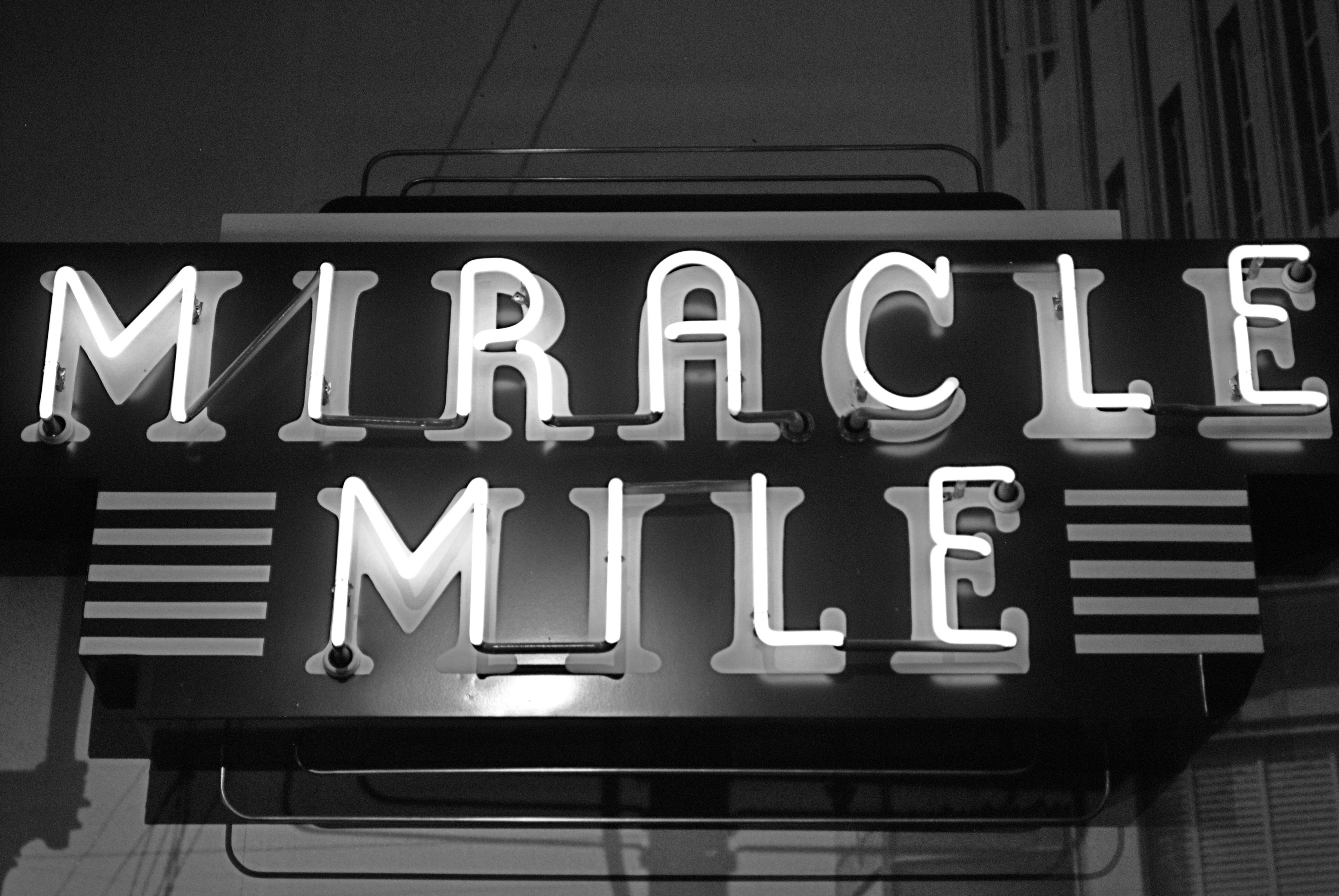
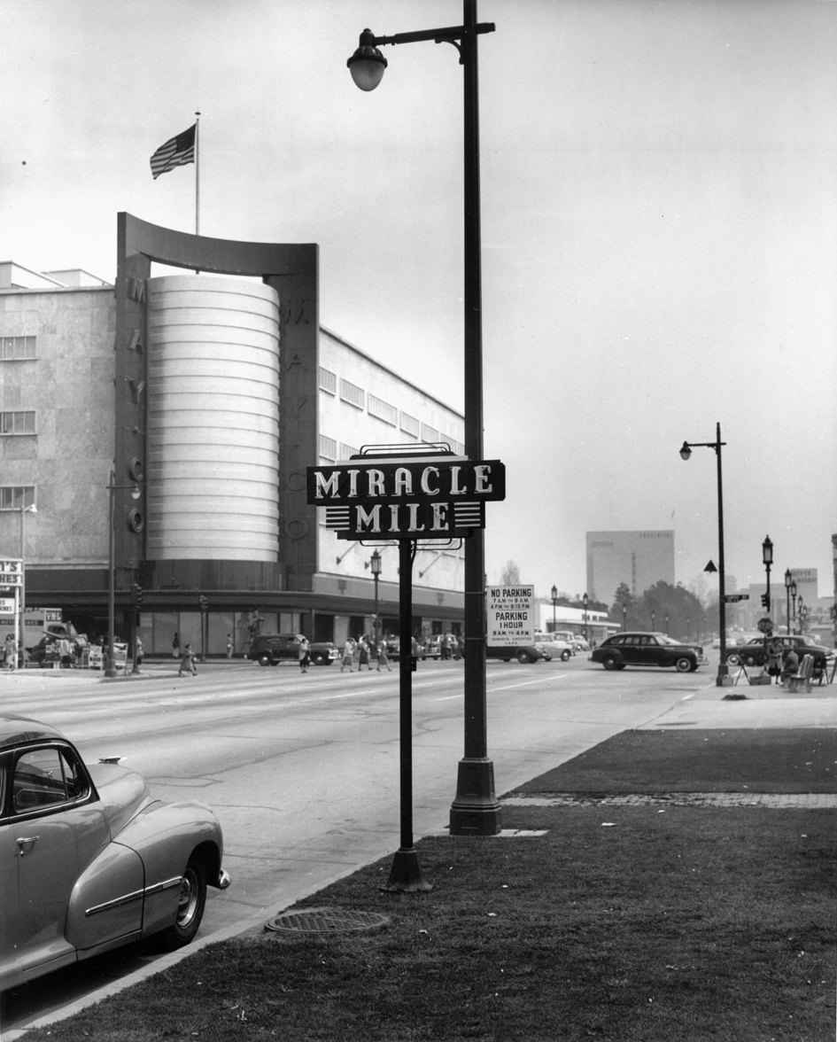
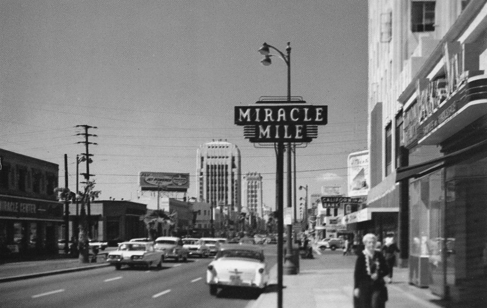
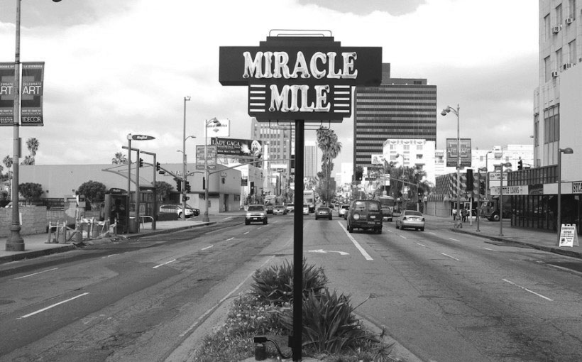
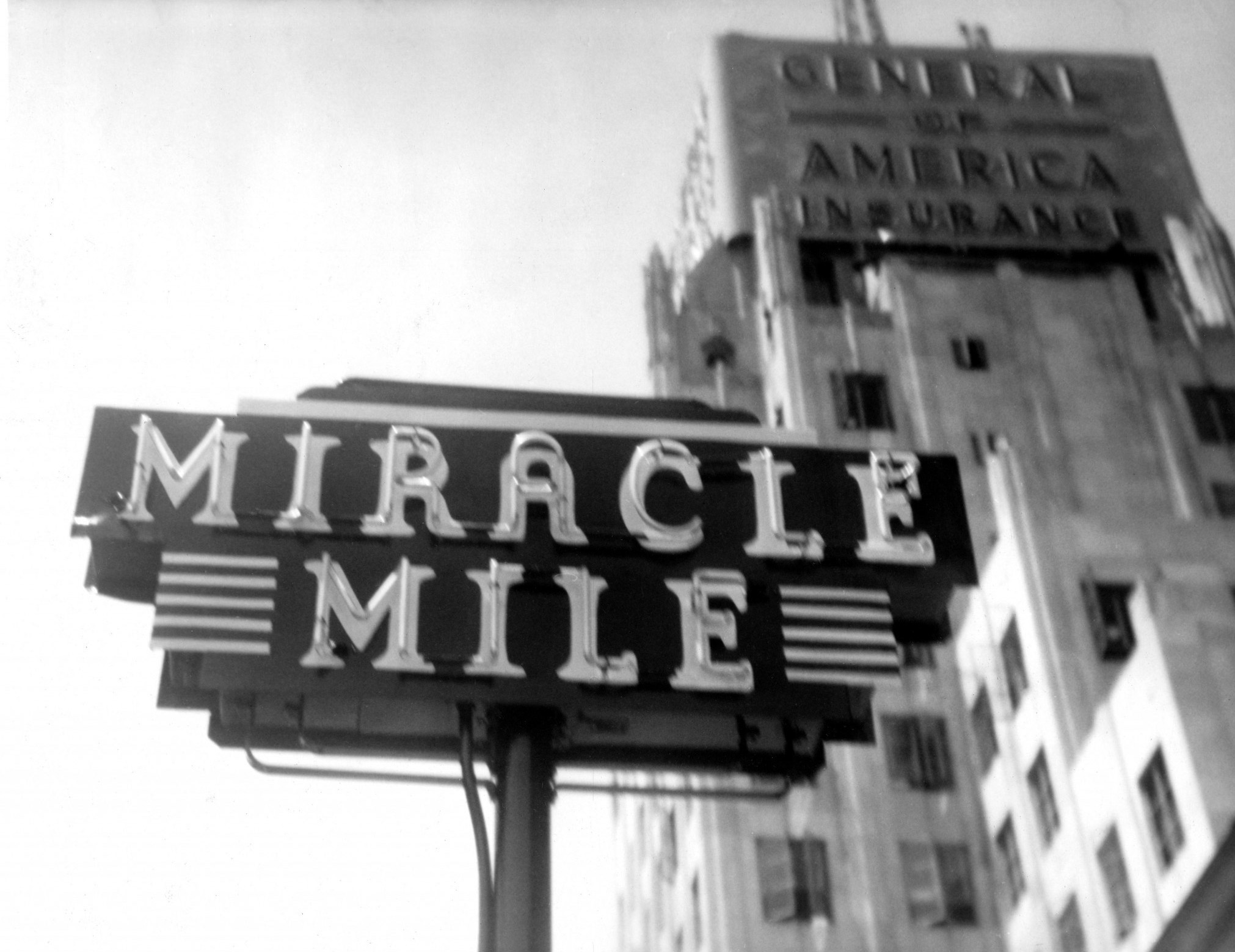
| “Miracle Mile” neon signs at the eastern and western gateways to the Miracle Mile first appeared in the 1930s. The most recent recreations of these historic signs were destroyed by automobile accidents. Metro plans to install new versions of the signs once they have completed construction of the Purple Line subway stations at those intersections.^ |
Historical Notes Beckoned by open space and the grand new boulevard, wealthy Angelenos flocked to the prestigious new district starting at the turn of the century. Residential and commercial development continued moving west for the next 30 years, both along and well beyond Wilshire Boulevard itself, but few people at the turn of the century predicted the development of the western reaches of Wilshire Boulevard. The area that would become the Miracle Mile was thought of by most as laughably distant from Los Angeles. |
Wilshire and Fairfax
 |
|
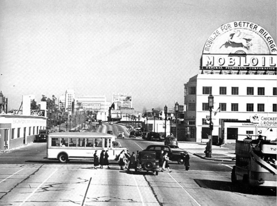
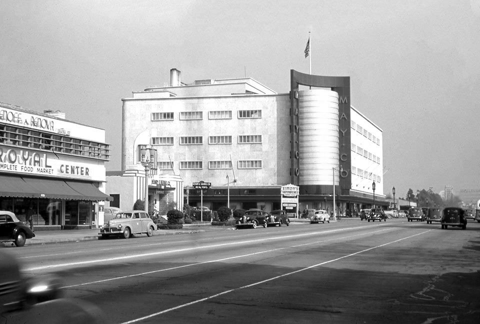
| (1938)^ – View looking east on Wilshire Boulevard at Fairfax Avenue. At right is a double-decker bus on the Los Angeles Motor Coach Wilshire Line and crossing Wilshire is a bus on the Fairfax Avenue line. The building on the right with the rooftop Mobil Gas billboard is the 6030 Wilshire building (later the location of the A+D Museum). The building on the left (NE corner) will be torn down to make way for the May Compnay Building (built in 1939-1940). |
Historical Notes Developer A.W. Ross foresaw a grand commercial destiny for western Wilshire Boulevard earlier than anyone else. In the early 1920s, Ross began buying up land along Wilshire Boulevard between La Brea Avenue and Fairfax Avenue, a pursuit some referred to as “Ross’s Folly.” He envisioned a destination shopping district that would lure customers from Beverly Hills as well as Hollywood and downtown Los Angeles, and encouraged the construction of architecturally distinctive commercial buildings. Ross’s development gamble along the western part of Wilshire Boulevard paid off in spades from the late 1920s and through the 1930s, as “Ross’s Folly” became known as Miracle Mile. The area housed large retailers like Desmond’s, Silverwoods, and the May Company, and even supermarkets like Ralph’s boasted flashy architecture on a grand scale. Ross remained a major force in the development of Wilshire Boulevard until the 1960s, seeing the boulevard lure the city’s population ever westward.* |
 |
|
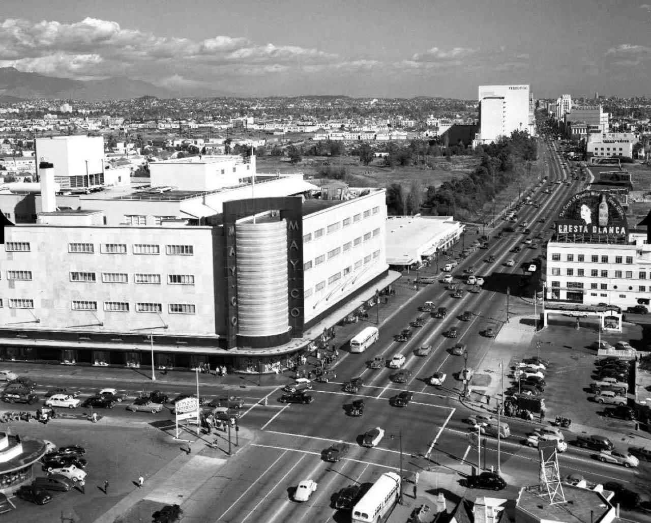
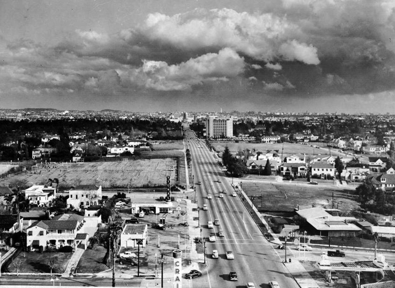
| (1940s)* – Aerial view of Wilshire Blvd facing east at Fairfax Ave, showing the May Company department store on the NE corner. Simon's Drive-in can be seen at lower-left on the NW corner. This intersection was, and still is, referred to as the western gateway to the Miracle Mile. Source: Bison Archives |
Historical Notes It was not until 1928 that the Miracle Mile acquired its glamorous appellation. Ross originally gave his development a much less-memorable name: Wilshire Boulevard Center. According to a story Ross was describing his vision for the development when a friend interjected: "From the way you talk, A.W., one would think this is really a miracle mile." The name, with its obvious promotional value, stuck.^ |
 |
|
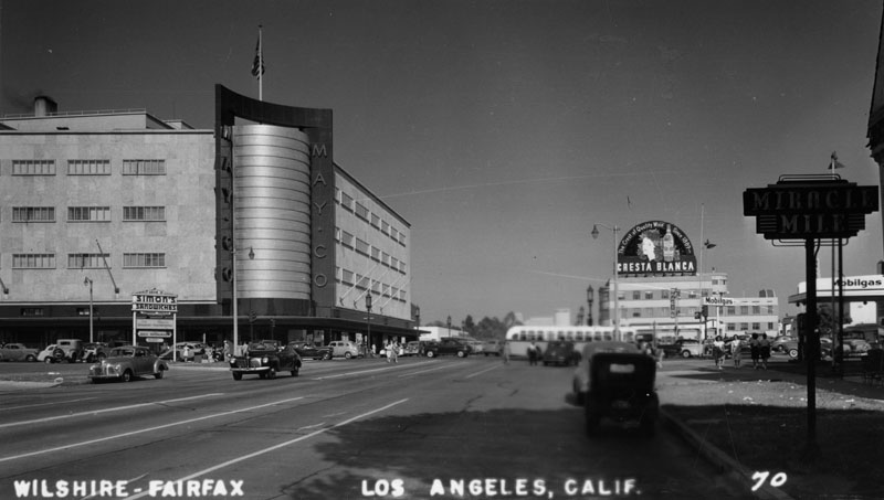
| (1947)^ - Postcard view of the beginning of the Miracle Mile, at Fairfax and Wilshire, with the May Company Building prominently seen in the background. A large sign for Simon's Drive-in Restaurant can be see at left on the NE corner. |
Historical Notes A. W. Ross saw potential for the area and developed Wilshire as a commercial district to rival downtown Los Angeles. Ross's insight was that the form and scale of his Wilshire strip should attract and serve automobile traffic rather than pedestrian shoppers. He applied this design both to the street itself and to the buildings lining it. |
Simon's Drive-in Restaurant
 |
|
| (1939)* - View showing Simon's Drive-in Restaurant on the northwest corner of Fairfax Avenue and Wilshire Boulevard. This is an engineering notebook photoprint taken from top deck of Wilshire Boulevard Bus. |
Historical Notes Simon's Drive-in Restaurant was built in 1935 and looks very similar to many of the other drive-ins built in the 1930s. That's because so many of these futuristic looking drive-ins were designed by architect Wayne McAllister. Wayne McAllister was a Los Angeles-based architect who was a leader in the Googie style of architecture that embraced the automobile and the Space Age. Inspired by tail fins and gleaming chrome, he elevated the drive-in restaurant to futuristic works of art. He created iconic circular drive-in restaurants in Southern California, including Simon's, Herbert's, Robert's, and McDonnell's in the 1930s. |
 |
|
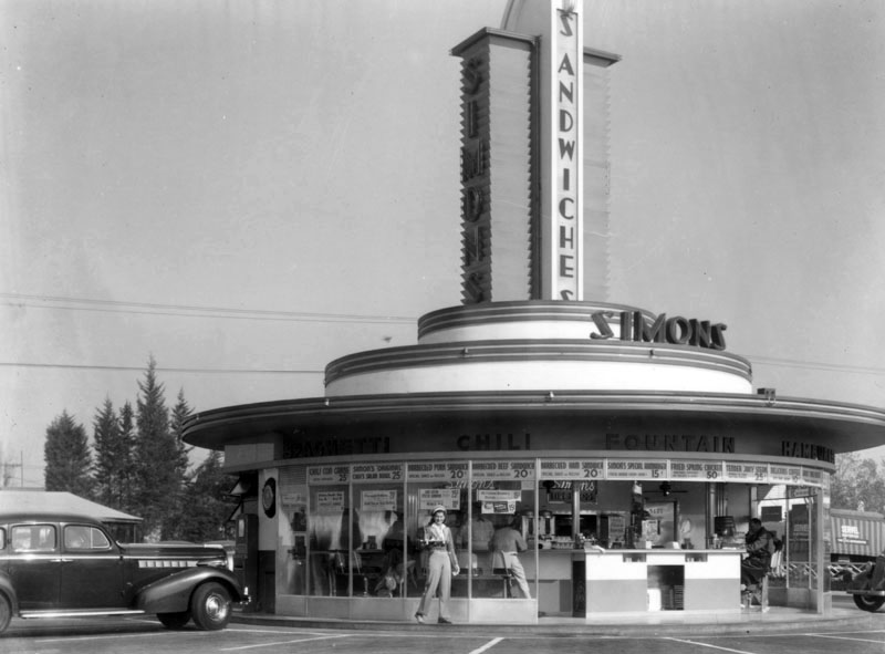
| (1939)^ - A daytime view of Simon's Drive-in Restaurant located on the northwest corner of Fairfax and Wilshire. Through the glass floor-to-ceiling windows, patrons can be seen sitting at the circular counter having their meals. "Spaghetti", "Chili", "Fountain", "Hamburgers" and "Barbecue" can be seen above the windows. A carhop is standing at front, holding food in her hand. |
Historical Notes At one time Simon's Drive-ins dominated the Southern California drive-in restaurant craze. The Simon brothers had operated a chain of successful dairy lunch counters in downtown Los Angeles, and in 1935 decided to capitalize on the growing car culture of Los Angeles by opening auto friendly locations in the emerging commercial centers of Wilshire Boulevard, Sunset and Ventura Boulevards. Click HERE to see more Early LA Drive-in Restaurants. |
 |
|
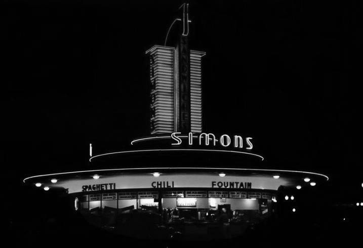
| (ca. 1940s)* - Night view showing the neon-lit Simon's Drive-in Restaurant at Fairfax and Wilshire, NW corner. |
Historical Notes This is the same corner where the 1950s Johnie's Coffee Shop now stands. Across the street is the old May Company department store building which is now a part of LACMA/the Hollywood Museum. Going back further to the early 1900s, this is where the Chaplin Airfield was once located (Click HERE to see more in Aviation in Early L.A.). |
 |
|
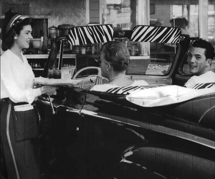
| (ca. 1948) – A couple of jitter-bugs down at Simon's Drive-in wowing the waitress with their zebra-stripe upholstery. |
 |
|
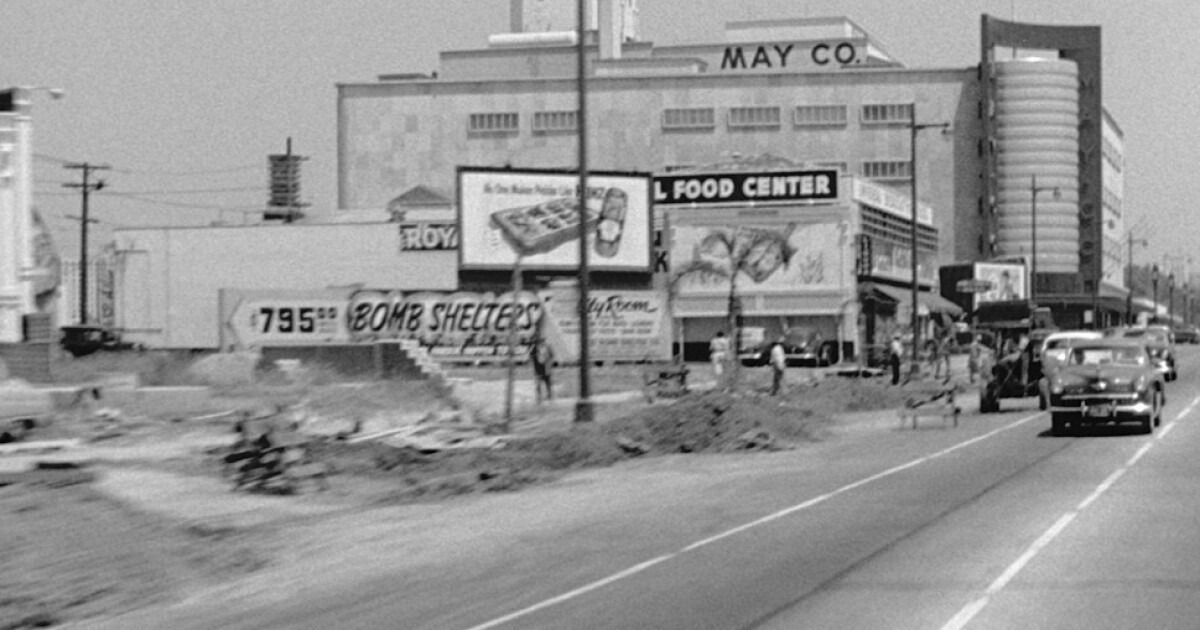
| (1950s)* - Looking east on Wilshire Blvd toward Fairfax Ave with the Royal Food Center and May Company in the background. Note the billboard on the left advertising “BOMB SHELTERS” for $795. |
Historical Notes The bomb shelter craze, also known as the fallout shelter craze, occurred primarily during the 1950s and 1960s. This period was characterized by heightened tensions and fears related to the Cold War between the United States and the Soviet Union. The development and testing of nuclear weapons, as well as the threat of a potential nuclear conflict, led many people to seek ways to protect themselves and their families in the event of a nuclear attack. The craze reached its peak in the early 1960s during the Cuban Missile Crisis in 1962, when the United States and the Soviet Union came to the brink of nuclear war. This event heightened the sense of urgency and increased the demand for bomb shelters. The government encouraged citizens to build their own shelters, and there were various public and private initiatives promoting the construction of fallout shelters. |
 |
|
| (1944)^.^ – View looking east on Wilshire Blvd towards Fairfax Ave showing May Company on the NE corner. Across the street (N/W corner) can be seen Simon’s Sandwiches drive-in restaurant. Next to Simon’s is the Art Deco Krandill Mortgage and Investment Company building. |
 |
|
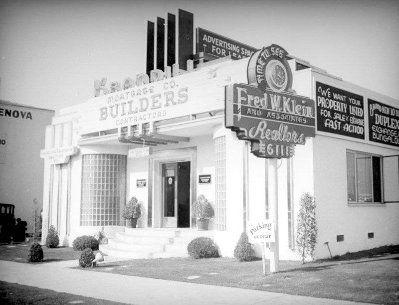
| (ca. 1937)* – Krandill Mortgage and Investment Company featuring builders and contractors is located at 6111 Wilshire Boulevard near Fairfax, just West of Simon’s Drive-in. The Streamline Moderne building features a rounded glass brick entrance and stepped neon sign. A neon clock pole sign announces that it is time to see Fred W. Klein and Associates, Realtors. The rooftop billboard space is for lease, and has interesting Late Moderne features that have been integrated into the building. |
 |
|
| (1948)*# - View of the Miracle Mile and the May Company Building, looking east down Wilshire Boulevard. Different styles of streetlights run up and down Wilshire Boulevard. Click HERE to see more in Early Los Angeles Street Lights. |
Historical Notes The Miracle Mile development was initially anchored by the May Company Department Store with its landmark 1939 Streamline Moderne building on the west and the E. Clem Wilson Building on the east, then Los Angeles's tallest commercial building. |
 |
|
| (1940s)^ - View looking at the intersection of Fairfax Avenue and Wilshire Boulevard. The May Company Building can be seen on the northeast corner. |
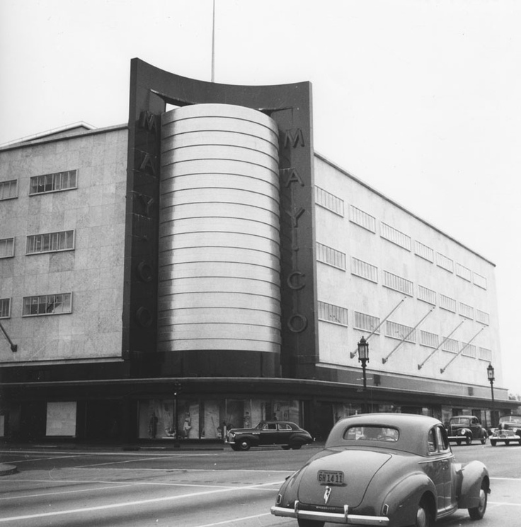
Historical Notes The May Company Building has a Streamline Modern style with gold corner towers. Built in 1940. Architects: A.C. Martin, S.A. Marx. In 1992, the building was designated LA Historic-Cultural Monument No. 566 (Click HERE to see complete listing). May Company California was established in 1923 when May acquired A. Hamburger & Sons Co.(founded in 1881 by Asher Hamburger). The company operated exclusively in Southern California until 1989 when May Department Stores had dissolved Goldwater's, based in Scottsdale, Arizona and transferred its Las Vegas, Nevada store to May Company California.^* |
 |
|
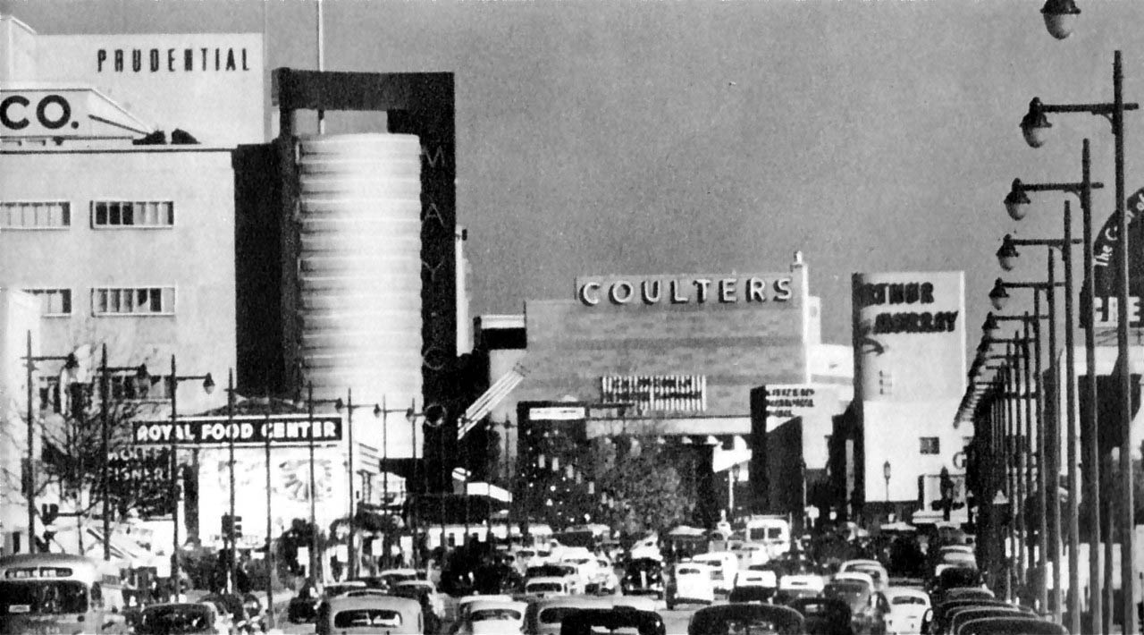
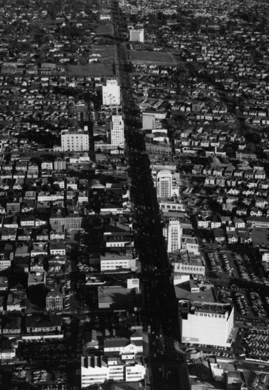
| (1940s)* – Panoramic view using telephoto lense looking east on Wilshire Boulevard through the Fairfax Avenue intersection. We can see the May Company department store (now part of LACMA and future home of the Hollywood museum of the Academy of Motion Picture Arts and Sciences), Prudential Building, Coulter's Department Store, and the Arthur Murray Dance Studio. This “Miracle Mile” stretch of Wilshire Blvd is busy now but back then it looks positively jam-packed! |
Historical Notes Ross gave Wilshire various "firsts," including dedicated left-turn lanes and timed traffic lights, the first in the United States. He also required merchants to provide automobile parking lots, all to aid traffic flow. Major retailers such as Desmond's, Silverwood's, May Co., Coulter's, Mullen & Bluett, Myer Siegel, and Seibu eventually spread down Wilshire Boulevard from Fairfax to La Brea. Ross ordered that all building facades along Wilshire be engineered so as to be best seen through a windshield. This meant larger, bolder, simpler signage and longer buildings in a larger scale. They also had to be oriented toward the boulevard and architectural ornamentation and massing must be perceptible at 30 MPH instead of at walking speed. These building forms were driven by practical requirements but contributed to the stylistic language of Art Deco and Streamline Moderne.^ |
 |
|
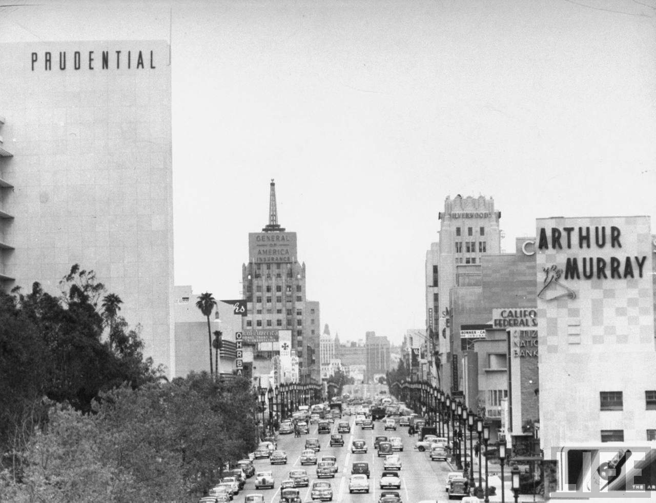
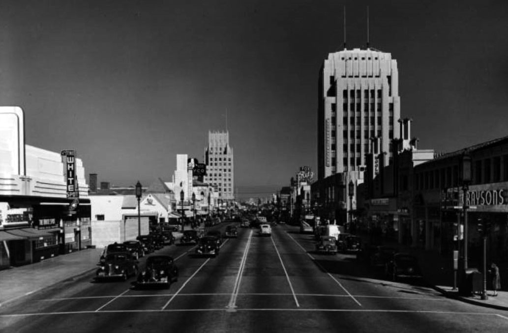
| (1949)**^ - View looking east of Wilshire Boulevard from Curson Avenue showing the heart of the Miracle Mile. Some of the more recognizable building include the (l to r): Prudential Building, E. Clem Wilson Building, (Wilshire & La Brea, NE Corner), Wilshire Tower, and Arthur Murray Dance Studio. |
Historical Notes Ross's moves were unprecedented, a huge commercial success, and proved historically influential. Ross had invented the car-oriented urban form — what Reyner Banham called "the linear downtown" model later adopted across the United States. The moves also contributed to Los Angeles's reputation as a city dominated by the car. A sculptural bust of Ross stands at 5800 Wilshire, with the inscription, "A. W. Ross, founder and developer of the Miracle Mile. Vision to see, wisdom to know, courage to do." As wealth and newcomers poured into the fast-growing city, Ross's parcel became one of Los Angeles's most desirable areas. Acclaimed as "America's Champs-Élysées," this stretch of Wilshire near the La Brea Tar Pits was named "Miracle Mile" for its improbable rise to prominence. Although the preponderance of shopping malls and the development in the 1960s of financial and business districts in downtown and Century City lessened the Miracle Mile's importance as a retail and business center, the area has retained its vitality thanks to the addition of several museums and commercial high-rises.^ |
 |
|
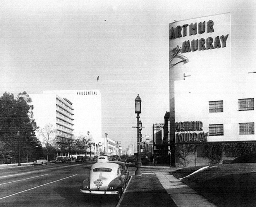
| (ca. 1950)^^ - View looking east on Wilshire Blvd at Stanley Ave. The Arthur Murray Dance Studio is on right (SE corner) and the Prudential Building can be seen in the distance on the left. Hancock Park and the La Brea Tar Pits. Photo by Dick Whittington |
Historical Notes Arthur Murray launched his third business in 1925 by selling branded dance lessons through franchising. He trained dance instructors for the Statler Hotel chain, who then went to various hotels and gave lessons; Murray kept some of the profits from each franchise. This business was expanded more widely in 1938, when an Arthur Murray dance studio franchise was opened in Minneapolis, Minnesota. Others followed. His slogan was: "If you can walk, we teach you how to dance", and the company guaranteed that the pupils learn to dance in ten lessons. After WWII, Murray's business grew with the rise of interest in Latin dance, and he regularly taught and broadcast in Cuba in the 1950s. Murray went on television with a dance program hosted by his wife, Kathryn Murray, The Arthur Murray Party, which ran from 1950 to 1960, on CBS, NBC, DuMont, ABC, and then on CBS. The Murrays retired in 1964; but they continued to be active for some time, appearing as guests on the Dance Fever disco show in the late 1970s. By then, there were more than 3,560 dance studios bearing his name. In 2007, about 220 Arthur Murray Studios remained in operation. Arthur Murray Dance Studios claims to be the second-oldest franchised company (the first, A&W Restaurants, began in 1919). *^ Click HERE to see more on the Moderne-style Arthur Murray Dance Studio Building (seen above) designed by Stiles O. Clements (1941). |
 |
|
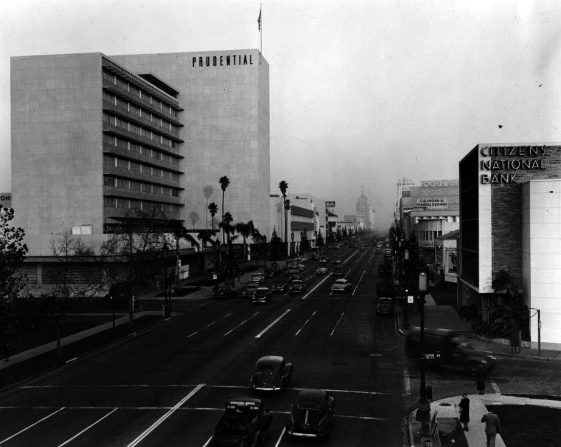
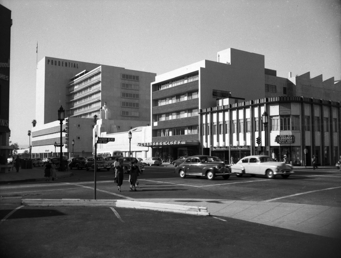
| (1950)^^ - Corner of Wilshire Boulevard and Curson Avenue across from Hancock Park and the La Brea Tar Pits. The Prudential Building, Citizen National Bank, Orbachs, Ralph's supermarket, California Federal Savings, Bank of America are all located within this area. Click HERE for contemporary view. |
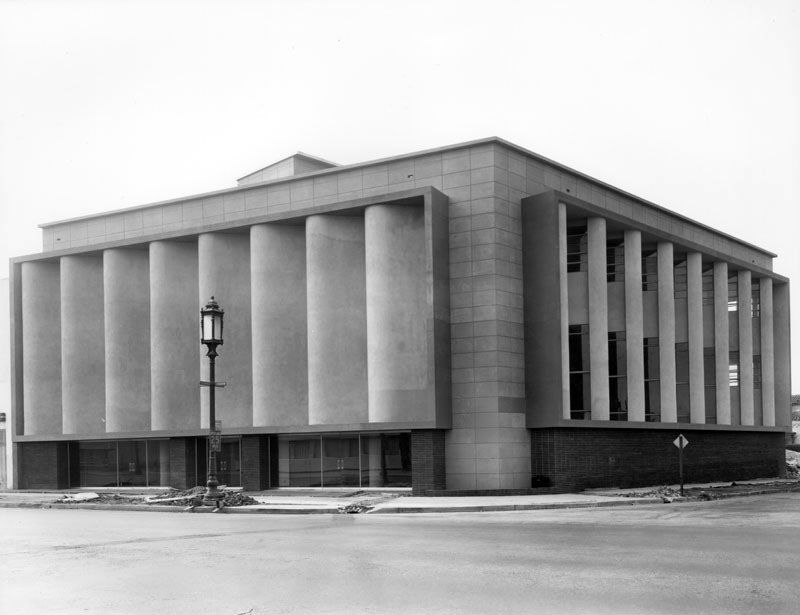
Historical Notes The Prudential Building (aka Prudential Square) opened in 1948, housing more than 1,200 employees of the western office of Prudential Insurance Company. It was designed by famed architects Walter Wurdeman and Welton Becket in the International Style and was the tallest and largest privately owned building in the city when it opened. The duo also designed the Pan-Pacific Auditorium. In 1993, Screen Actors Guild moved its national headquarters into the building and the American Federation of Television and Radio Artist’s followed in 1997. In 2015, the historic Miracle Mile building at 5757 Wilshire Blvd. was renamed SAG-AFTRA Plaza. |
 |
|
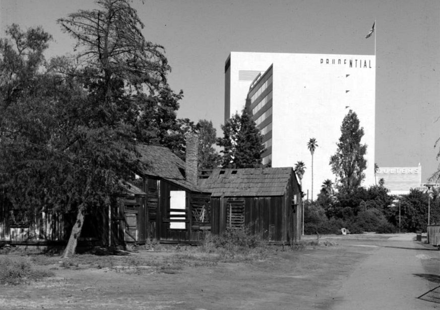
| (1950)^^ - View showing the ranch house built in the 1880s by Henry Hancock on Rancho La Brea shortly before its demolition with the 1948-built Prudential Building in the background. This is also the location of the La Brea Tar Pits. |
Historical Notes As a lawyer, Henry Hancock worked for the Rocha family to aid them with their efforts to prove their claim to Rancho La Brea. The Rochas finally won their claim, but like so many other rancheros, their legal expenses left them broke. In 1860 Jose Jorge Rocha, the son of Don Antonio Jose Rocha, deeded Rancho La Brea to Henry Hancock. Click HERE to see more in early views of La Brea Tar Pits. |
 |
|
| (1954)^*** – Aerial view looking west showing the full extent of the Miracle Mile at left with Park La Brea Towers at upper center-right. The intersection of Wilishire and La Brea is at lower-left. The Prudential Building and La Brea Tar Pits can be seen at upper center-left. |
Historical Notes Strictly speaking, the term “Miracle Mile” applies to the section of Wilshire Boulevard between Sycamore Avenue, which runs just east of La Brea Avenue, and Fairfax Avenue, which forms the district’s boundary to the west. However, and not unusually for Los Angeles, where geographic terminology is not always precise, Miracle Mile connotes a larger geography. Sometimes it incorporates the section of Wilshire Boulevard stretching east of La Brea all the way to Highland Avenue. Used generically, it also includes the surrounding neighborhoods, such as the Park La Brea apartment development located to the north and the residential tracts located to the south.^^ |
 |
|
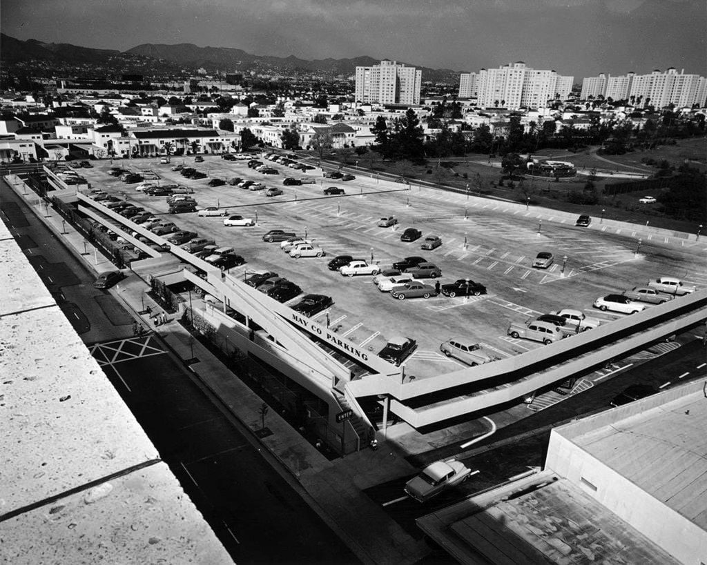
| (ca. 1953)* – View looking northeast from the roof of the May Co. Building showing multi-level store parking below, the Park La Brea Towers, and the Hollywood Hills in the distance. Photo by Julius Shulman via Getty Collection |
 |
|
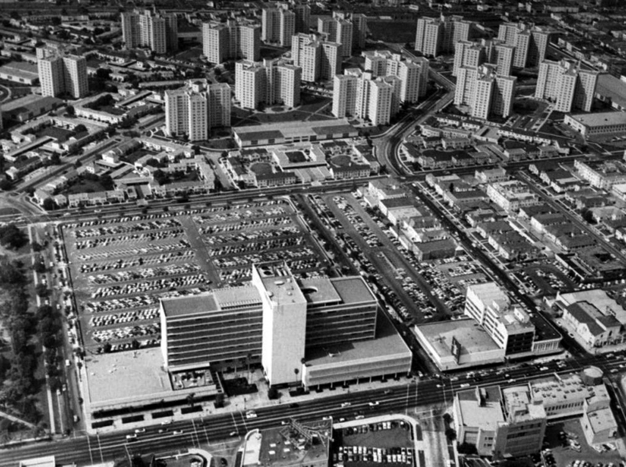
| (ca. 1950)^ - Aerial view looking north showing the Prudential Building at 5757 Wilshire Boulevard in the foreground with Park La Brea Towers at top. The eastern edge of the La Brea Tar Pits can be seen at left. |
Historical Notes Park La Brea was originally conceived as an entirely low-rise development. Construction began in 1941, but building restrictions during WWII halted work in 1945 with only the western half of the site completed. By the time construction resumed in 1948, the continued demand for postwar housing had prompted builder, MetLife, to dramatically revise the project to provide greater density and site amenities. The second phase of development included 18 towers rising to the city’s 13-story height limit in addition to three groups of two-story buildings matching those already built. |
 |
|
| (1949)* - Looking west on Wilshire from the SE corner of Wilshire and Hauser. The 1948-built Prudential Building, located at Wilshire and Curson, is seen at left. Click HERE to see contemporary view. |
Historical Notes The building seen on the right, NW corner of Wilshire and Hauser, was originally called the Western Auto Supply Co. Building It was built in 1931 and designed by Carl Lindbom. Today it is an IHOP. |
 |
|
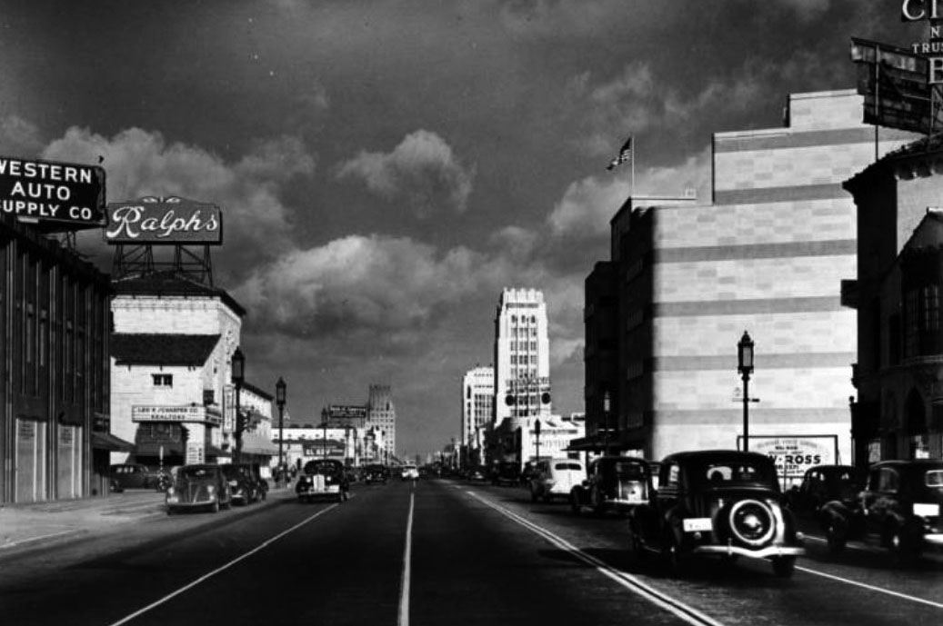
| (1938)* - Facing east on Wilshire Boulevard at Hauser Boulevard. Western Auto Supply Co., Ralphs Supermarket, Leo P. Schaeffer Company Realtors, Silverwoods Hand-Craft Mart, El Rey, Bank of America, Coulter's, Phelps-Terkel, the Dominguez tower (behind Desmond's/Silverwood's) and the E. Clem Wilson tower. |
 |
|
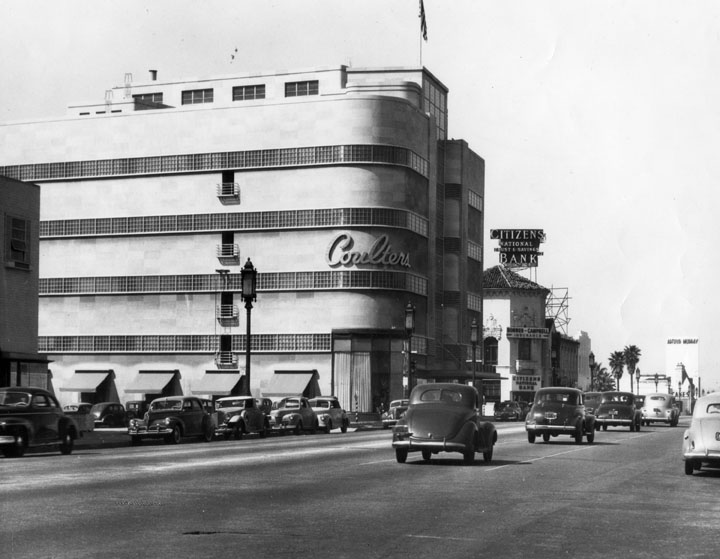
| (1938)^ - View looking at the southwest corner of Wilshire and Hauser boulevards showing the newly constructed Coulter's Department Store. |
Historical Notes Designed by Stiles O. Clements, this classic Streamline Moderne building was built in 1938 and was first occupied by Coulter's Dry Goods. In the 1970s, the store changed hands and became a Broadway. After the building was demolished in 1980, the site remained vacant until the late-2000s, when a 5-story mixed-use structure was built. |
 |
|
| (ca. 1940)^ - View looking west on Wilshire Boulevard. The Coulter Building is seen on the southwest corner of Hauser and Wilshire. Citizens National Trust & Savings Bank may also be seen on the right. |
Historical Notes B. F. Coulter was one of the earliest merchants in Los Angeles. The Coulter's Dry Goods business dates from 1878 and later was called Coulter's. Coulter was an ordained minister and founded the Broadway Christian Church. The business was continued by B.F. Coulter's son-in-law, R. P. McReynolds, and his son, James McReynolds. Click HERE to see more Early Views of Coulter's Department Store. |
 |
|
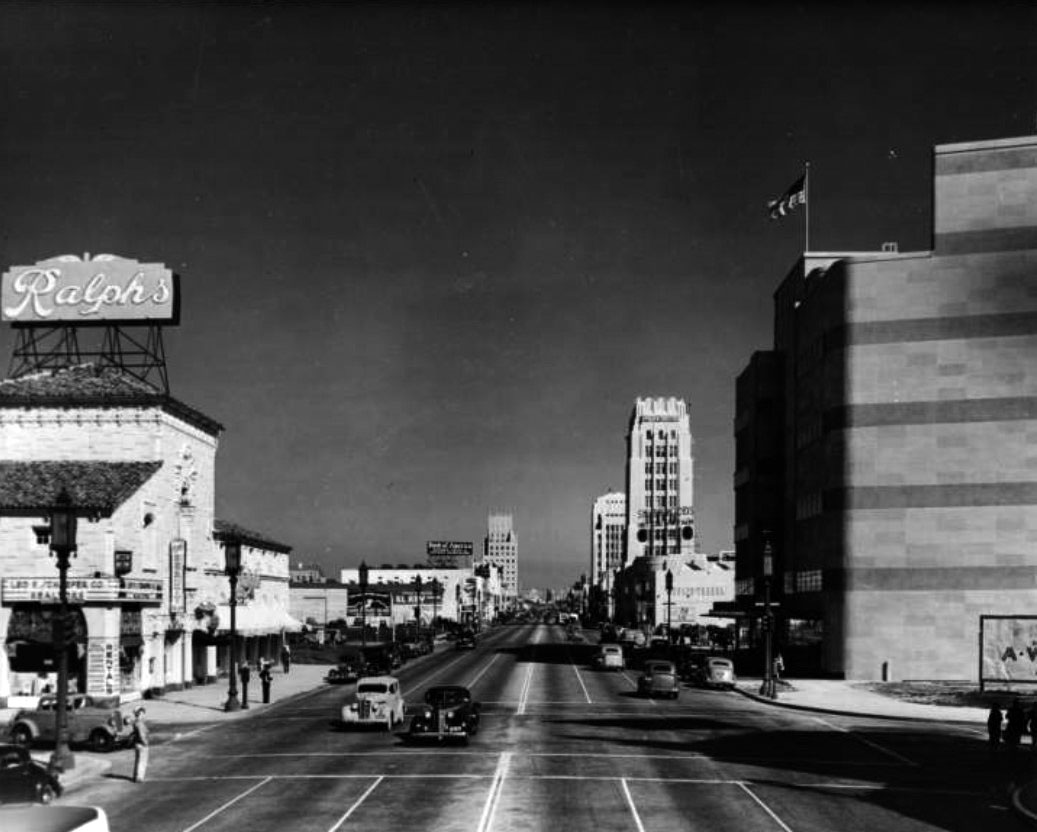
| (ca. 1939)* - View looking east on Wilshire Boulevard at Hauser Boulevard. Ralphs Market stands on the NE corner and Coulter's on the SE corner. |
 |
|
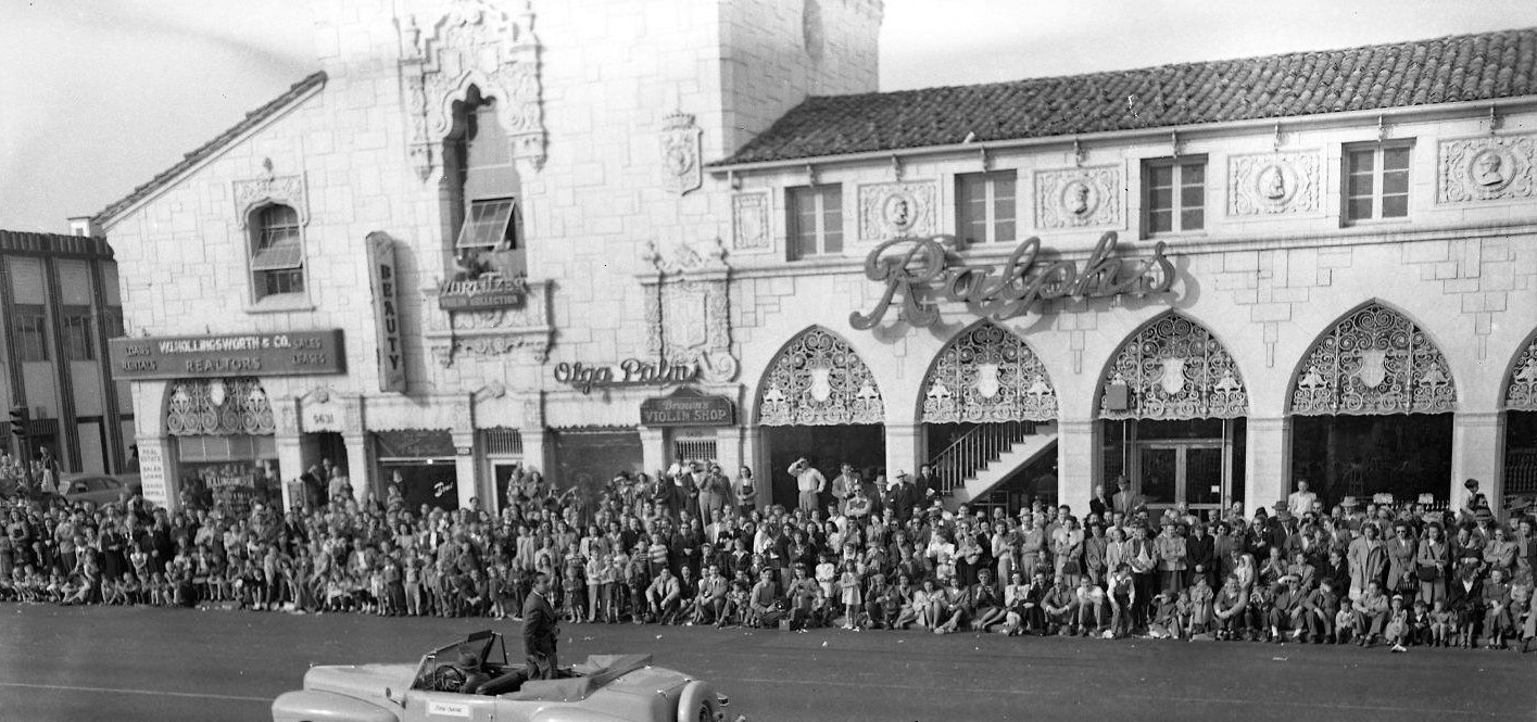
| (ca. 1950)^ - View showing what appears to be a parade in front of the 1928-built Ralphs Market located on the NE corner of Wilshire and Hauser. Part of the Western Auto Supply Co. Building can be seen on the left (NW corner). |
Historical Notes The Ralphs building with a sidewalk arcade was designed by Morgan, Walls and Clements and constructed in 1928. At the time, all the new Ralphs stores were built in the Churrigueresque style popular in Southern California, an ornate Spanish Revival style that architect Stiles O. Clements defined and perfected. Each of the new Ralphs was unique yet similar, exuding strength through large blocks of faux masonry, intricate wrought ironwork, prominent display windows, and Spanish tile roofs.^ |
 |
|
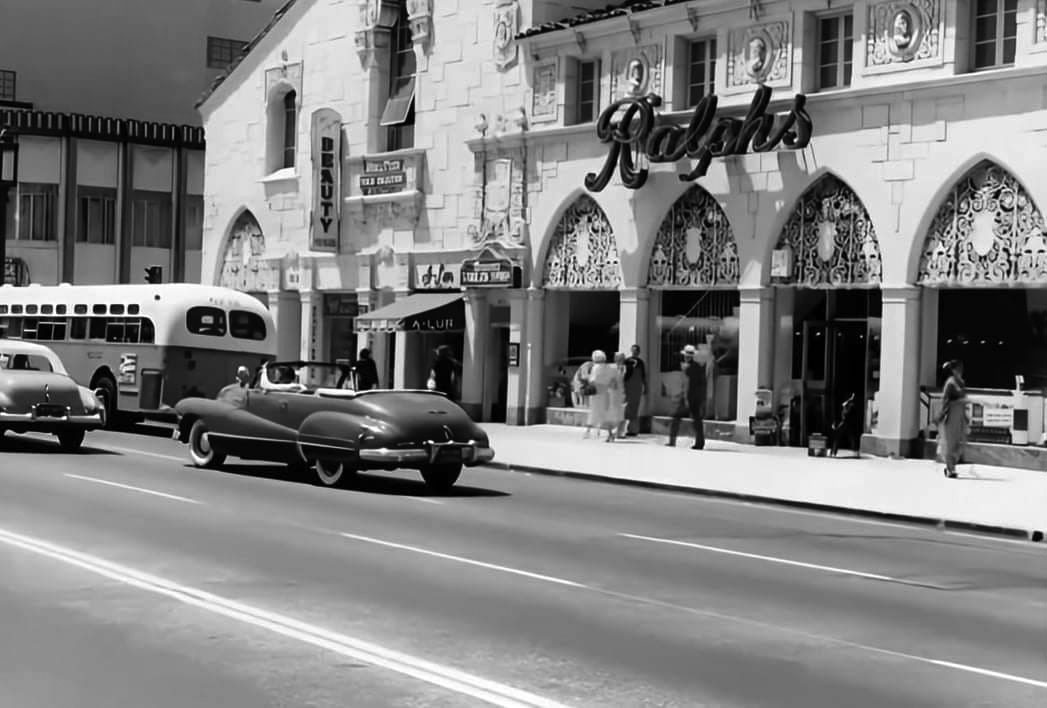
| (1950s)* - Ralph’s Market located at 5598 Wilshire Blvd. Photo courtesy of David E. Wentworth |
Historical Notes In the 1980s, Ralphs fell to the wrecking ball along with its midcentury neighbor, Du-Pars Coffee Shop. Unlike the area's Art Deco structures, neither building was protected from demolition. They were replaced by a block-long Alpha Beta grocery store, which was eventually bought out by Ralphs, unintentionally bringing the property full circle.^ Click HERE for contemporary views. |
 |
|
| (ca. 1957)^ – A woman stands on the SE corner of Wilshire and Hauser waiting for the light to change. In the background, on the north side of Wilshire, can be seen (l to r): Prudential Square, Ohrbach's, Van De Kamp’s, Marfay Building (see below), and the 1931-built Western Auto Supply Co. Building. The streetlights seen above (Wilshire Special) will soon be changed to two lamp fixtures (see next photo). Courtesy of Miracle Mile Residential Association |
Historical Notes The 5-story commercial building at 5657 Wilshire Boulevard was built in 1949 by the Marfay Development Co., and designed by the firm of Walter Wurdeman and Welton Becket, who also moved their firm’s offices into the top floor. Welton Becket & Associates kept its Los Angeles office here through the end of the 1950s, when their space was taken up by William L. Pereira & Associates. Eventually, Pereira’s firm occupied the entire building, where it remained until its founder’s death in 1985. It was likely at that point that the original International Style facade was torn down for its Postmodern replacement.* Click HERE for contemporary view. |
 |
|
| (1959)^ – View looking west on Wilshire Boulevard from Hauser Boulevard. Note that Orbach’s Department Store is located in Prudential Square, it would later move to the former Seibu Department Store (now Peterson Museum) at Wilshire and Fairfax. The Van de Kamp’s restaurant, across the street from Orbach's, was the largest in the chain. Note how the streetlights have been changed since the previous photo was taken. |
Historical Notes The Van de Kamp’s Restaurant, on the NE corner of Wilshire and Masselin, was originally the site of the Wilshire Bowl, a nightclub that offered dinner and dancing to the big-band sounds. It was followed by two other nightclubs, Slapsy Maxie's and Mardi Gras before being torn down to make room for Van de Kamp's. |
 |
|
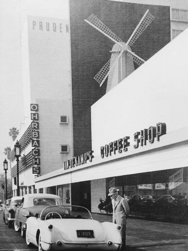
| (1950s)* – A man checking out a convertible sports car in front of Van de Kamp's coffee shop. |
Historical Notes Van de Kamp's Holland Dutch Bakeries was a bakery founded in 1915 and headquartered in the Van de Kamp's Bakery Building in Los Angeles. The company's trademark blue windmills featured on their grocery store signs and atop their chain of famous restaurants that were known throughout the region. |
 |
|
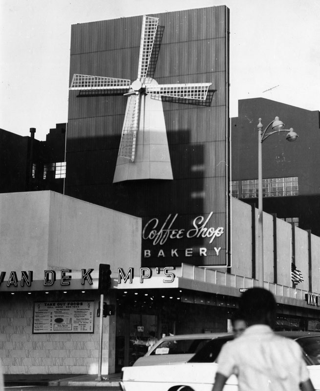
| (ca. 1960s)^ - View showing Van de Kamp's Coffee Shop and Bakery located at 5665 Wilshire Boulevard, NE corner of Wilshire and Masselin. Today, this is the site of an Office Depot. Click HERE for contemporary view. |
Historical Notes The bakery was sold by the Van de Kamp family and acquired by General Baking Co. in 1956. The company was sold to private investors in 1979, and closed in bankruptcy in 1990. Former Los Angeles County District Attorney John Van de Kamp is a grandson of the baker's founder. The family also founded Lawry's Restaurants and the Tam O'Shanter Inn.^* |
 |
|
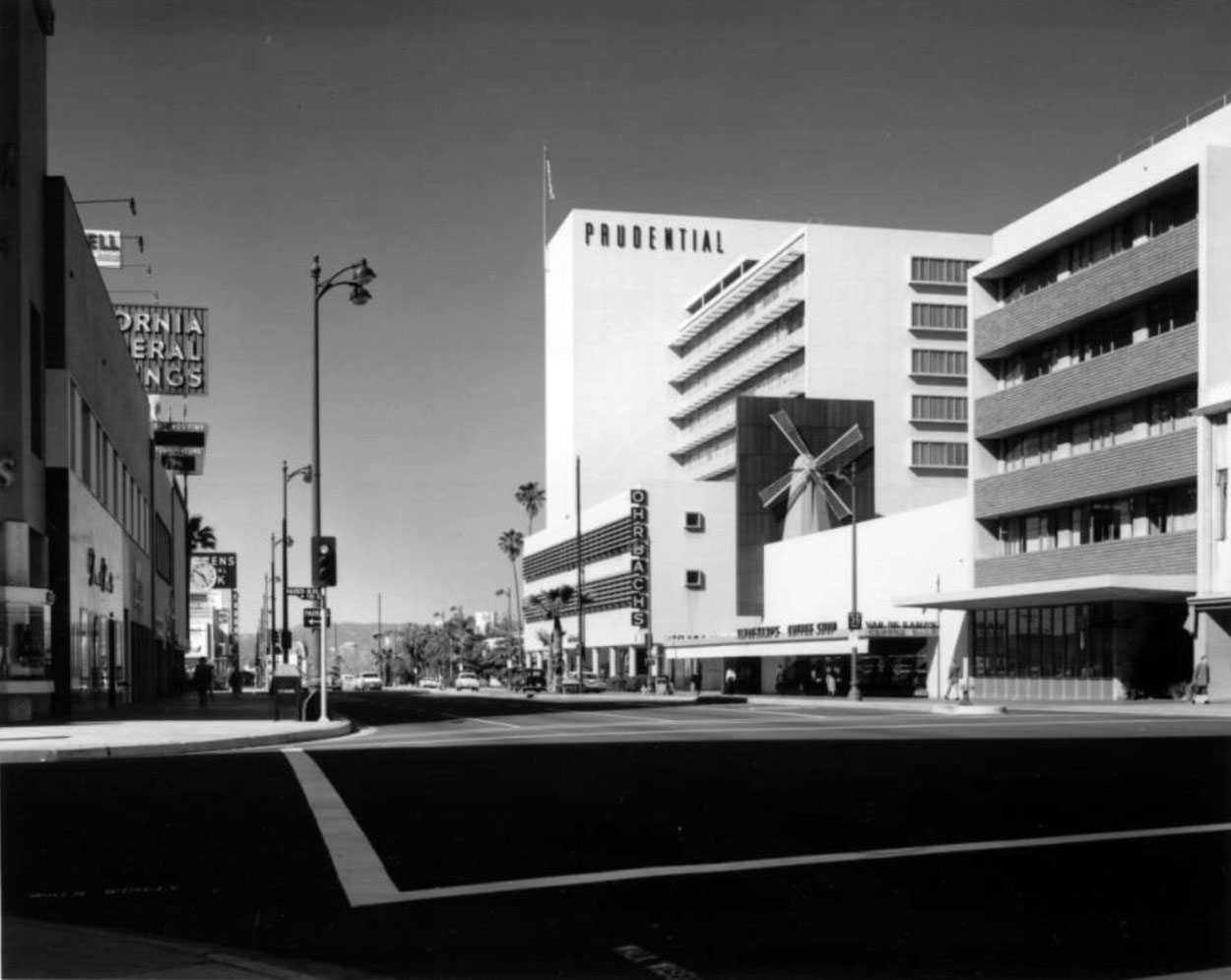
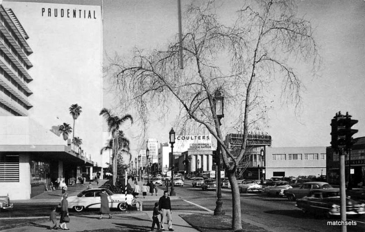
| (1950s)^ – Postcard view looking east from the northwest corner of Wilshire and Curson with Prudential Square on the left. Coulters and California Federal Savings can be seen in the distance. |
Historical Notes Designed by Wurdeman and Becket and built in 1948, the Prudential Building was later renamed Museum Square. |
 |
|
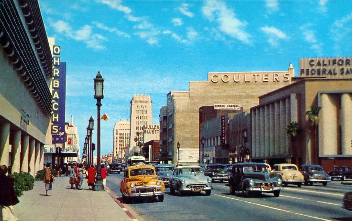
| (1950s)*- Linen finish postcard of Wilshire Boulevard looking east. Note the Orbach’s sign on left. Orbach’s was originally located in the Prudential Square complex. The block housing the California Federal Bank building later became the site of the “Cal Fed” skyscraper (1965). |
Historical Notes Ohrbach's department store was housed in the Prudential Square complex until 1965, when the store relocated to another Becket design down the street, the former Seibu Department Store (now the Petersen Automotive Museum). |
 |
|
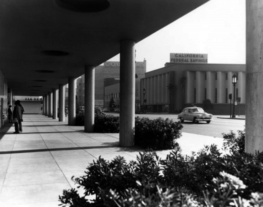
| (1951)^ - A view of Wilshire Boulevard at Masselin Avenue. People are standing on the sidewalk under the Prudential Building overhang, and behind is a Van de Kamp's Bakery. At right is California Federal Plaza Building and Coulter's Department Store. |
 |
|
| (ca. 1950)^ - California Federal Savings, Wilshire and Masselin, SE corner. [Ralph Morris Collection; Los Angeles Public Library. |
Historical Notes The block housing the California Federal Bank building seen above would later became the site of the “Cal Fed” skyscraper (1965). |
 |
|
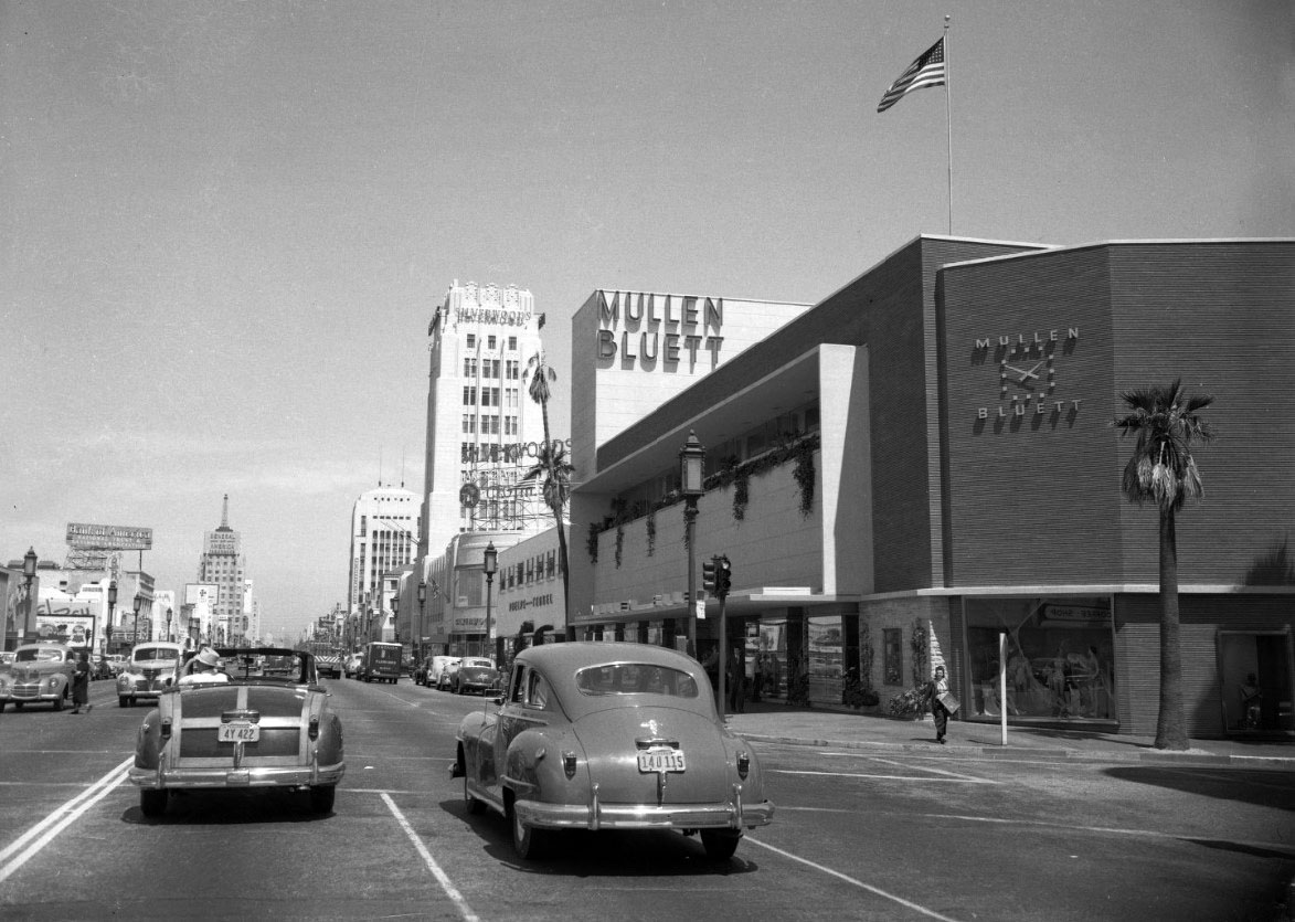
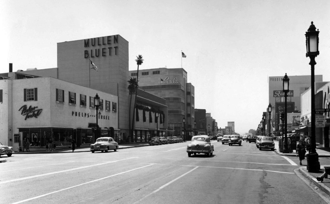
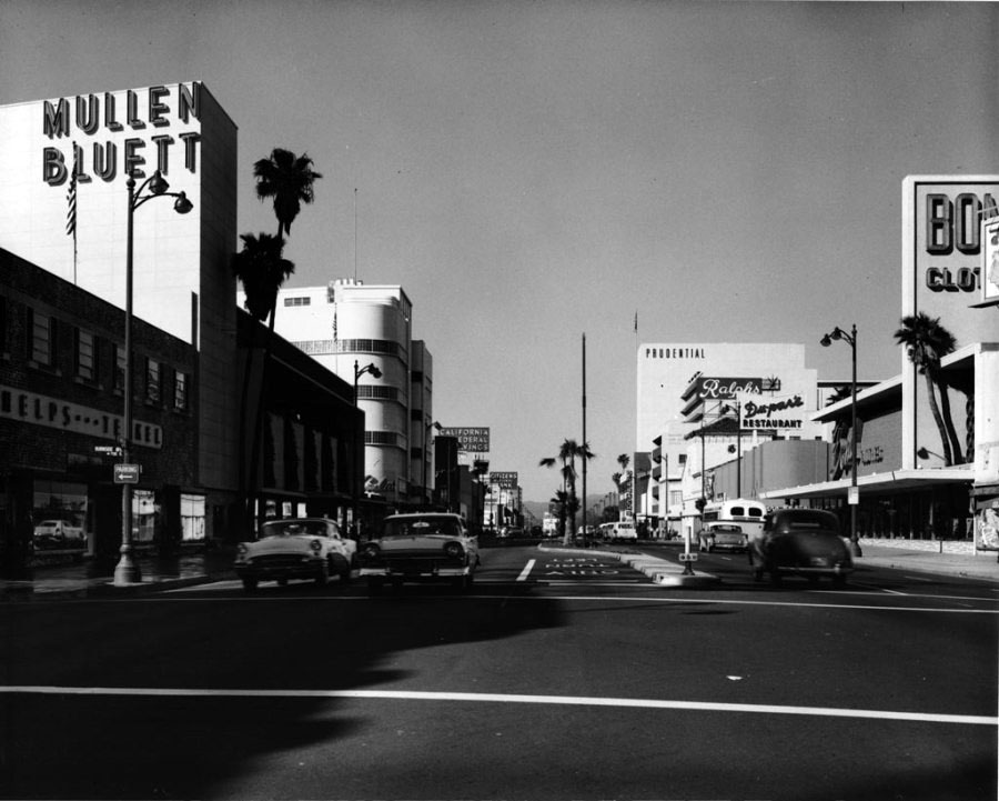
| (1949)* – View looking east on Wilshire Boulevard at Ridgeley Drive with the Mullen Bluett Building seen on the right. Other building signs include: Silverwoods, Wetherby Kayser, Bank of America National Trust & Savings Association, General of America Insurance. |
Historical Notes The once-popular Mullen and Bluett clothing store chain had several stores in Los Angeles, all designed by Stiles O. Clements in a distinct style to complement its neighborhood. The last of these stores rose on the Miracle Mile after World War II in the California style, bringing the outdoors in with welcoming patios, open display windows, and dozens of flagstone planter boxes scattered throughout the store. Clements designed every detail of the building, inside and out. A façade of Roman brick was balanced with a geometric grid of plasterwork and flagstone, softened by greenery, punctuated by copper-framed windows, and topped with an integrated sign pylon. Inside, women's and children's clothing were located on the second floor. Assuming that men would not travel as far as the second floor to shop, menswear and a convenient carousel of women's gift items were located on the first floor.^ |
Then and Now
 |
|
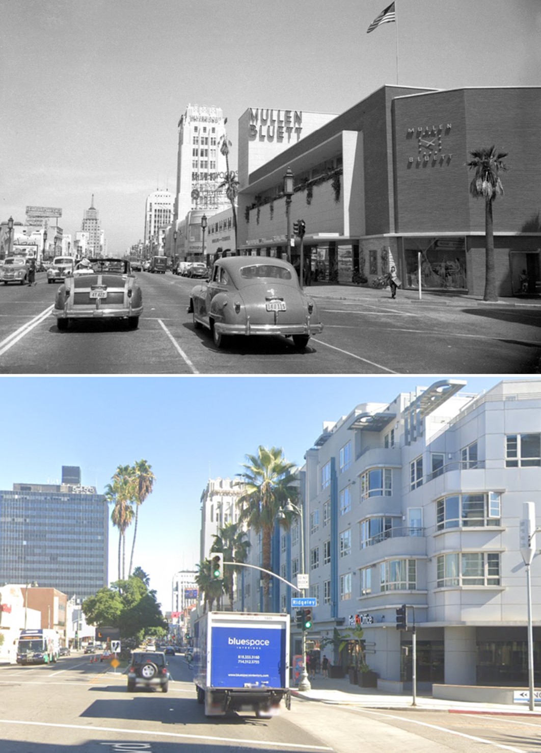
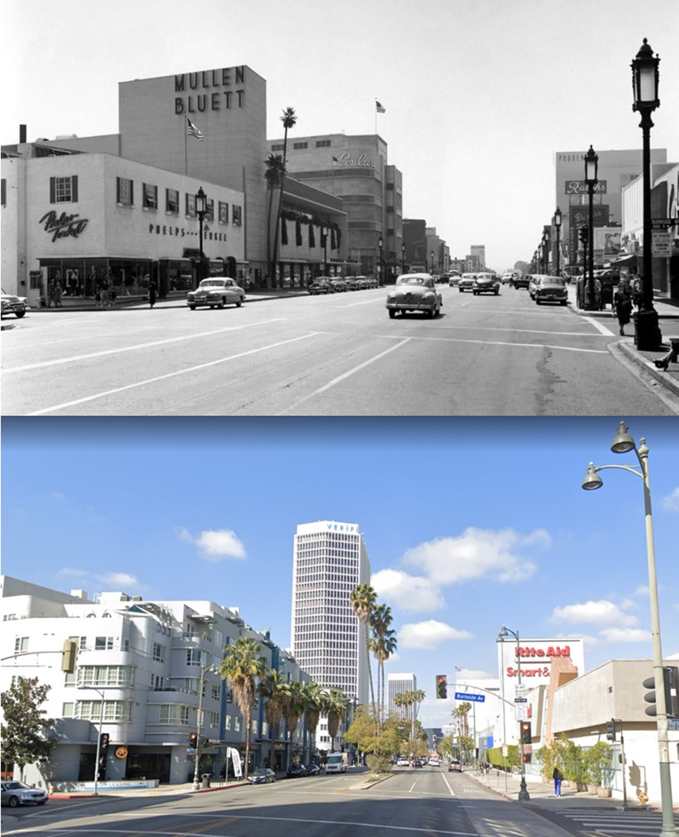
| (1949 vs 2023)* – Looking east on Wilshire Boulevard at Ridgeley Drive on the Miracle Mile. |
 |
|
| (1950)* – View looking west on Wilshire Blvd at Burnside Ave. On the SW corner is Phelps-Terkel Department Store with Mullen Bluett next door to the west. Further back, on the SW corner of Wilshire and Hauser, stand the 5-story Coulter's Department Store. |
Historical Notes Next door to Mullen and Bluett stood the 1936 Phelps-Terkel department store, designed by Morgan, Walls, and Clements. Together, they helped secure the Miracle Mile's reputation as a shopper's paradise. Both buildings succumbed over time to insensitive treatment and lack of protection, due largely to the priority placed on preserving the Miracle Mile's Art Deco buildings. A succession of owners and tenants over the years eventually gutted and subdivided the Mullen and Bluett building, though its façade remained intact. The Los Angeles Conservancy's Modern Committee fought to save both the Mullen and Bluett and Phelps-Terkel building, neither of which was designed in the Art Deco style. Both buildings were demolished in 2006 and replaced with an enormous apartment complex in a faux Art Deco design. ^ |
 |
|
| (ca. 1955)^– View looking west on Wilshire Boulevard at Burnside Avenue with Mullen Bluett and Phelps-Terkel seen on the left. Prudential, Ralphs, and Dupar's can be seen on the right. |
Historical Notes Stiles O. Clements designed the two-story, 55,000-square-foot Mullen and Bluett store in 1947-1948. It was demolished in 2006 to make way for a 5-story mixed housing. Click HERE for contemporary view. |
Then and Now
 |
|
| (1950 vs 2021)* - Looking west on Wilshire Boulevard at Burnside Avenue. |
 |
|
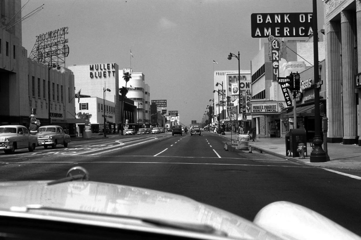
| (1954)^ - Westbound on Wilshire in a 1954 Buick Special approaching Masselin Avenue with Desmond's, Mullen Bluett, and Coulter's on the left, and Bank of America, El Rey, and Prudential on the right. Note that the streetlights along Wilshire have changed from a lamp-style to a dual-lamp configuration. Photo courtesy of Miracle Mile Residential Association |
Historical Notes In the mid-1950s the ornate 1928-installed streetlights along Wilshire Boulevard (called Wilshire Special), running from Fairfax Avenue to beyond Wilton Place, were replaced by a newer, higher efficient, two headed streetlight (referred to as the Wilshire Double). |
 |
|
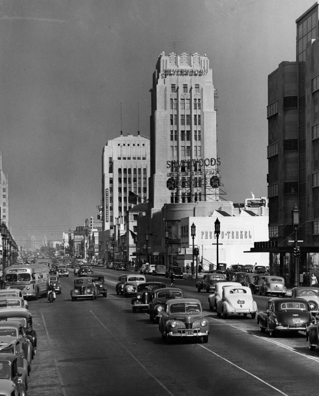
| (1949)^ - Looking east down Wilshire Boulevard at Burnside Avenue in the Miracle Mile. Silverwood's Clothes in the Wilshire Tower, the Phelps-Terkel building, and Wetherby-Kayser are seen at right with the Dominguez-Wilshire Building further back at center. Traffic is traveling down in both directions on Wilshire. F.B. Silverwood founded his first store at 124 So. Spring Street in the 1890s. |
Historical Notes When it opened on March 15, 1929, the Wilshire Tower fronted an entire city block and featured an 11-story Art Deco tower. Desmond's main entrance opened onto the sidewalk, but many shoppers entered through the rear; in a nod to the automobile's ascendency, the store's owners built a large parking lot behind the store and reserved additional space for future parking needs. Other retailers soon followed Desmond's to the Miracle Mile, and they, too, provided ample parking for their customers behind their buildings. Silverwood's arrived in September 1929.^ |
 |
|
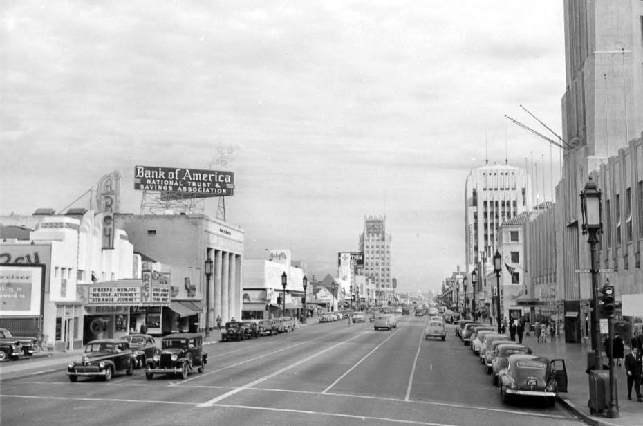
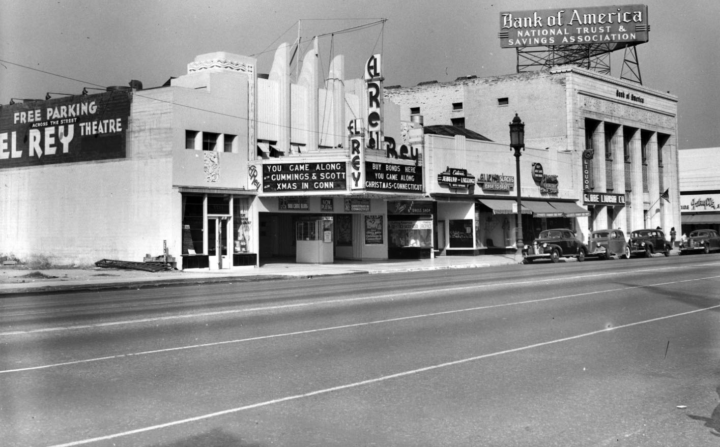
| (ca. 1947)^ – View looking east along Wilshire Boulevard showing the El Rey Theatre is on the left and Desmond’s Building (Wilshire Tower) is on the right. The El Rey Theatre is showing a double bill: “Mr. District Attorney” (1947) and “Strange Journey” (1946). Further back (from l to r) can be seen the Bank of America Building, E. Clem Wilson Building, and the Dominguez-Wilshire Building. |
 |
|
| (1945)* – View showing the El Rey Theatre located at 5515 Wilshire Boulevard with Bank of America seen on the right (NW corner of Wilshire and Dunsmuir Ave). |
Historical Notes The El Rey began its life in 1936 as an independent neighborhood theatre. With a succession of owners and tenants over the decades, the theatre has run the gamut from hosting spiritual services to showing adult films. It stopped showing movies in the 1980s. From the 1980s to the early 1990s El Rey Theatre was a dance-music club called Wall Street, but since 1994 this theatre has been a live music venue which is now exclusively booked through Golden Voice. The capacity is 771 and it also has a VIP balcony in the back.*^ Click HERE to see more of the El Rey Theatre. |
 |
|
| (1978)^ - Looking northwest across the intersection of Wilshire Boulevard and Dunsmuir Avenue towards an Art Deco and Egyptian revival style office building when it was occupied by Wilshire Insurance Company. |
Historical Notes Located at 5505 Wilshire Boulevard, this structure was originally constructed in 1930 as a branch office of the Seaboard National Bank. It was designed by Frank Rasche. It later served as a branch office of the Bank of America and now serves as the Korean Cultural Center.^ Click HERE to see contemporary view. |
 |
|
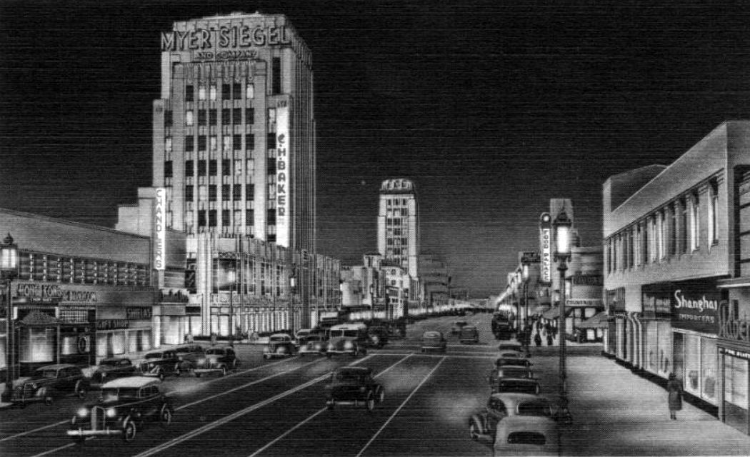
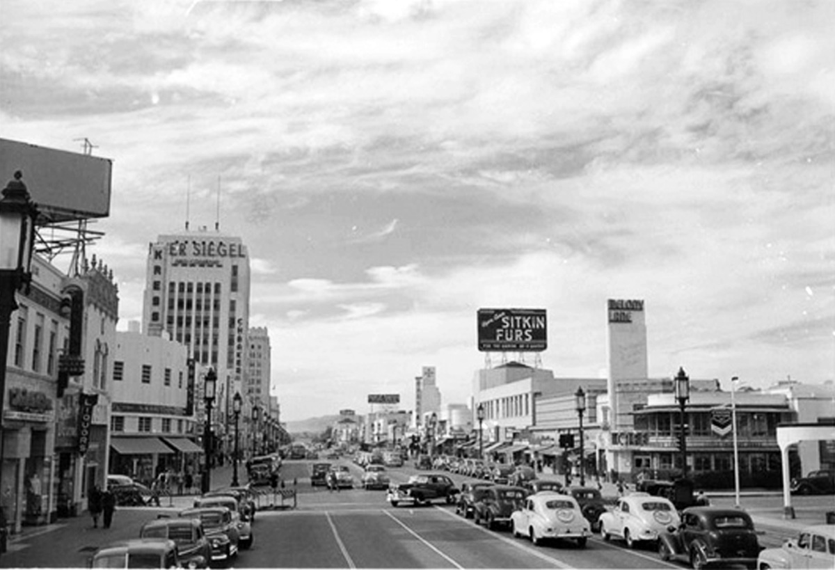
| (1940)#^*^ – Postcard view looking east on Wilshire toward Cloverdale Avenue showing the Dominguez- Wilshire Building (aka Myer Siegel Building) with the Wilshire Tower in the distance. |
Historical Notes The Dominguez-Wilshire building (also called the Myer-Siegel Building) was designed in 1930 by architects Morgan Walls and Clemens. The property was named after its developers, the Dominguez family, the heirs to the first land grant given in California by King Carlos III of Spain.*^ |
 |
|
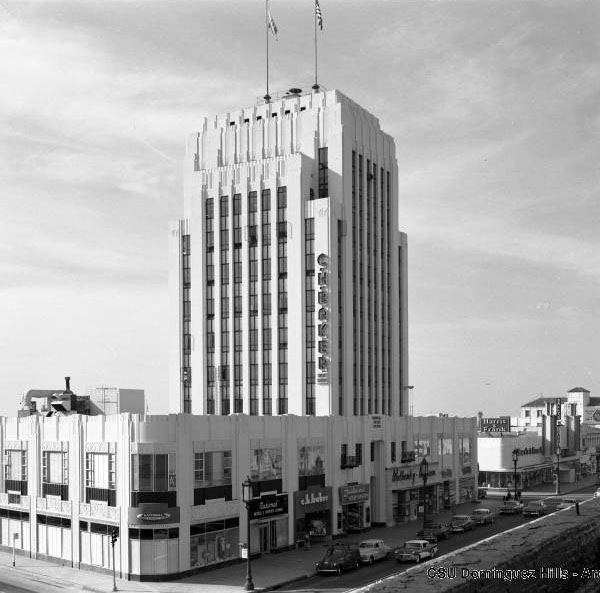
| (ca. 1955)^ - View looking at the SW corner of Wilshire Boulevard and Cloverdale Avenue showing the Dominguez- Wilshire Building (5410 Wilshire Blvd). Photo Courtesy of CSU Dominguez Hills. |
Historical Notes Zigzag motifs and a main automobile entrance at the rear defined this Art Deco office tower, the second built on the Miracle Mile after the Wilshire Tower at 5514 Wilshire. The building's lower floors were leased by Myer Siegel, a women's clothing store known for showing the latest fashions from Paris.^ |
 |
|
| (ca. 1939)^ – View looking west on Wilshire Blvd at Detroit Street with the Dominguez- Wilshire Building seen on the left. At right, on the northwest corner of Wislhire and Detroit Street, can be seen the Melody Lane Cafe. |
Melody Lane Cafe
 |
|
| (ca. 1937)^ – View looking west across Detroit Street at Wilshire Boulevard (lower left) showing pedestrians outside the Melody Lane Cafe. The restaurant's free parking is advertised by the sign on the left and a Wilshire Latern stands on this Miracle Mile corner. |
Historical Notes The structure occupied by the storefronts in the distance is still standing, but the restaurant was later demolished and replaced with a high rise, mixed-use structure. Click HERE for contemporary view. |
 |
|
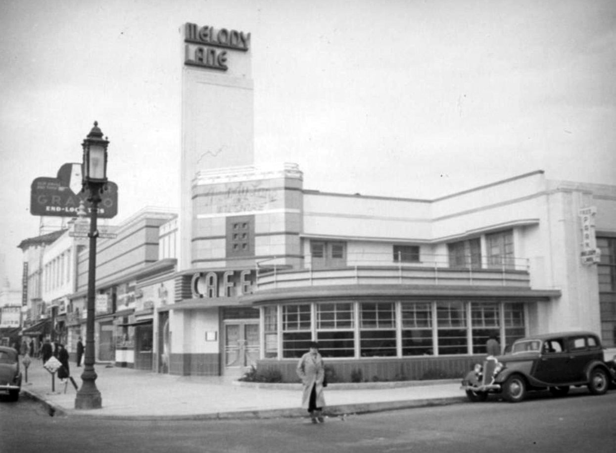
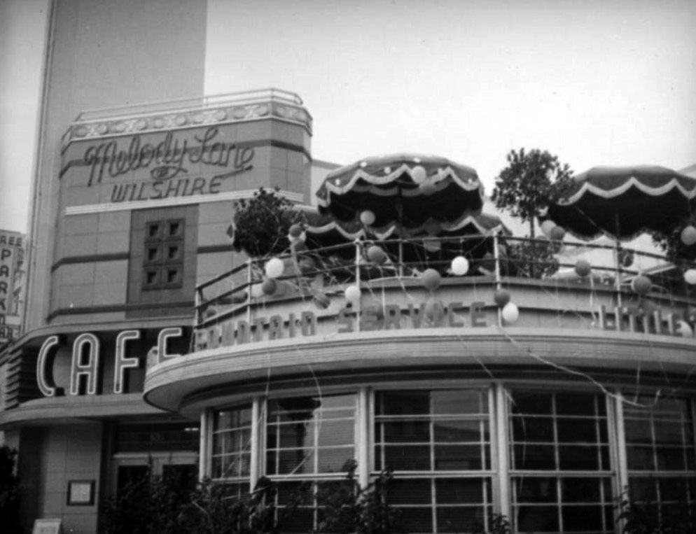
| (ca. 1938)^ - View showing the Melody Lane, located at 5351 Wilshire Boulevard at the corner of Detroit Street. There are two signs above the entrance doors: "Melody Lane of Wilshire" sign and a neon channel letter "cafe" sign. Patio dining under umbrellas is offered on the roof and balloons and streamers indicate a party is in progress. |
Historical Notes Melody Lane was owned by restaurateur Sidney Hoedemaker who also owned the Pig ‘n’ Whistle. There were three other Wilshire locations: at Detroit, at Western and at Beverly Drive. The most famous location was at Hollywood and Vine. |
.jpg) |
|
| (ca. 1937)^ - Two women are walking past the Melody Lane Cafe, located on the northwest corner of Wilshire Boulevard and S. Detroit Street. The entrance to the restaurant (one of two) features a huge keyhole in the middle. |
 |
|
| (ca. 1940)* - Wilshire Boulevard looking east from Dunsmuir Avenue; the White Spot, Wetherby-Kayser, Graysons, Woolworth's, Lilyans, New York Millinery, The Glorified Hamburger, The Food Palace, Melody Lane Cafe, the Fox Ritz Theatre and the Dominguez- Wilshire Building. Additional information: The Glorified Hamburger sign (seen at center-left) was a slogan for Wimpy Grills which was located on the northeast side of Cochran and Wilshire (5425 Wilshire). It eventually became the Flying Saucer, and is now (end of 2012) a Staples store that pays homage to a flying saucer. |
 |
|
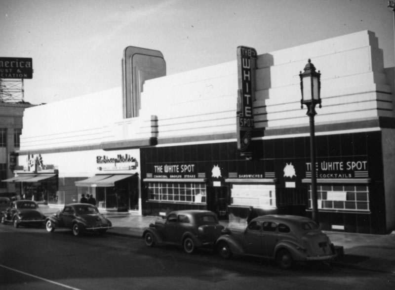
| (ca. 1940)* - View showing the White Spot restaurant and cocktail lounge on the north side of Wilshire Boulevard between Dunsmuir and Cochran Avenues (5467 Wilshire Boulevard). |
Historical Notes The name ‘White Spot’ was most likely derived from the nickname for the city itself: the “White Spot of America.” White Spot was a term embraced by city boosters based on maps produced by the US Chamber of Commerce in its magazine, The Nation’s Business. The maps illustrated business conditions in areas of the country shaded black (poor), white with black stripes (fair), and white (good). Los Angeles was a “white spot” in a sea of black and grey on the map in the early 1920s. Boosterism in LA was concentrated in the Chandler family dynasty that owned the LA Times, which took the “white spot” to be a validation of their own vision for the city’s development: The Times ballyhooed Los Angeles as “the White Spot of America,“ a city free of crime, corruption, communism, and by implication, non-white races. The LA Times had enormous influence on how that city developed, which was intensely anti-union and racially segregated in the early days. The term "white spot” typically referred to LA’s relative prosperity and low unemployment in such things as buy-local campaigns, but was also used in racial terms, such as a “keep the white spot white” drive to keep non-whites from moving into a white neighborhood.^ There was another White Spot Café located at 5357 Wilshire Boulevard. |
 |
|
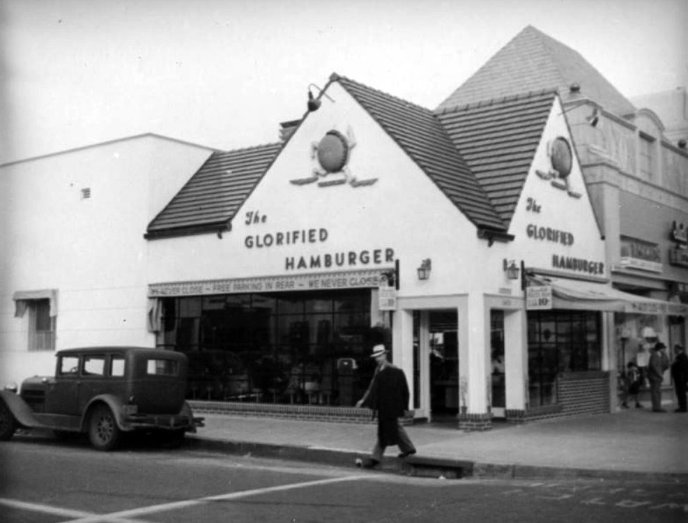
| (ca. 1938)* - Wimpy Grills at the NE corner of Wilshire Boulevard and Cochran Avenue in the Miracle Mile, is home to the "Glorified Hamburger." Signs indicate that the restaurant, which features a running hamburger shaped mascot, never closes. |
Historical Notes Wimpy Grills (located at 5425 Wilshire Boulevard, later the Flying Saucer restaurant) and the adjacent shops (later Brown's Wilshire Bakery) were remodeled to create one large commercial space to accommodate a Staples office supply store. |
 |
|
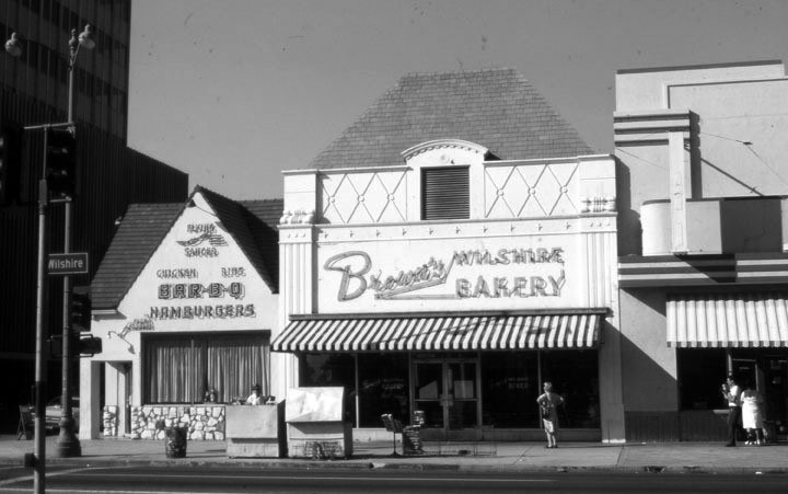
| (1980s)^ - Looking north across Wilshire Boulevard towards three businesses, the Flying Saucer restaurant (left), Brown’s Wilshire Bakery (former location of Judy Garland’s flower shop), and the Roman Foods Market (right). Roman Foods Market was formerly A&P Market (A&P Food Palace). |
Historical Notes In the late 1980s the Flying Saucer – formerly Wimpy’s – and Brown’s were demolished and a new building was constructed to include the Roman Foods structure as a Staples office supply store. Click HERE for contemporary view. |
 |
|
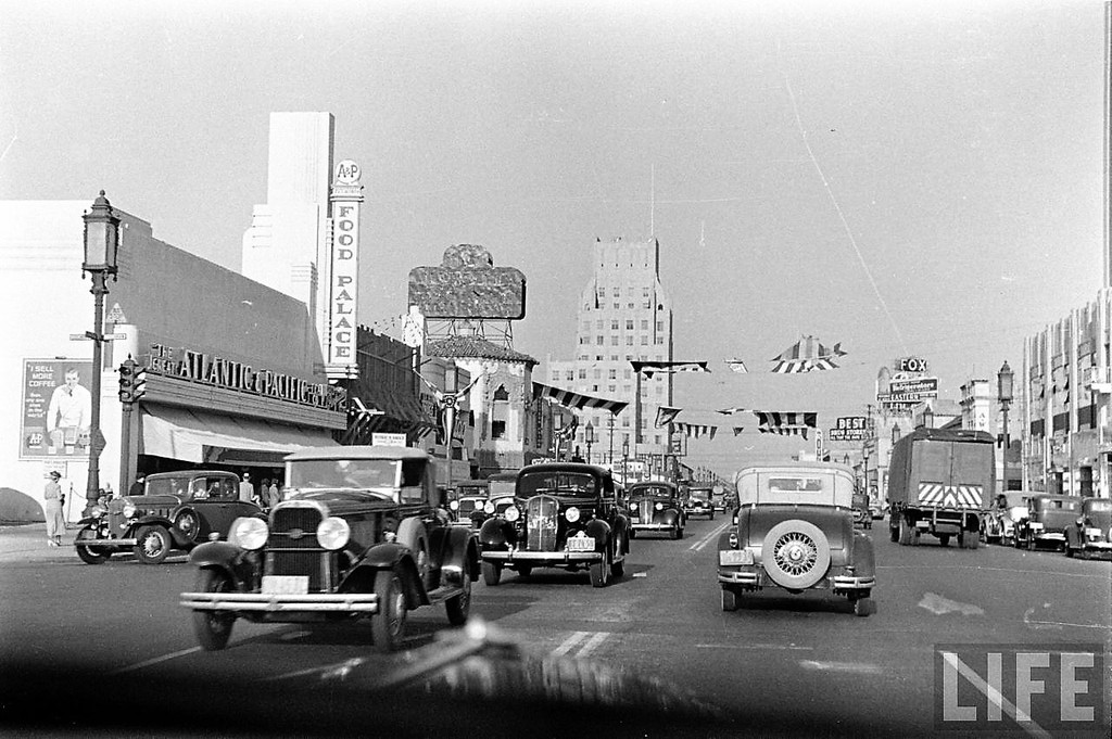
| (ca. 1939)* – Dashboard view looking east on Wilshire Boulevard toward La Brea Avenue. On the left is an A&P Market (A&P Food Palace). In the distance is the E. Clem Wilson Building (NE corner of La Brea and Wilshire) and across the street (SE corner) the large Fox Ritz Theatre sign. This A&P later became Roman Foods and is currently occupied by a Staples Store. |
Historical Notes The Great Atlantic & Pacific Tea Company, better known as A&P, was a chain of grocery stores that ceased supermarket operations in November 2015, after 156 years in business. The A&P stores evolved from the Great Atlantic and Pacific (A&P) Tea Company, founded in the 1800s in New York by George Hartford and George Gilman. In 1912, John Hartford, son of the co-founder, came up with the idea of expanding and forming the A&P Econonmy Store chain which would rely on a business model that included standarization of layout and elmination of credit accounts and delivery. The format was wildly successful, and the chain had grown from 585 stores in 1913 to more than 4500 stores by 1920, and to over 15,000 stores all over the east coast and Midwest by 1930. In the early 1930s, the first California stores were opened, adding some credibility to the company name. By the 1960s, A&P stores were stale, sales were flat, and the midwestern and west coast divisions were struggling. A well-publicized corporate reorganization in 1968 and 1969 did little to stem the decline, and the next two decades were defined by declining sales, closing stores, and failed format changes. Among the stores closed were the entire Southern California operation, in 1969, which eliminated A&P as a contender in the fastest-growing market in the country.^ |
 |
|
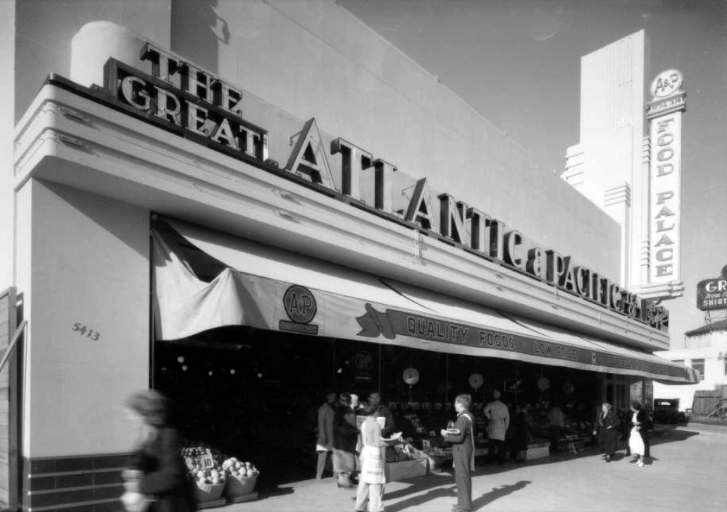
| (ca. 1935)* - View showing the Food Palace, an Atlantic & Pacific (A&P) Market located at 5413 Wilshire Boulevard, near the NE corner of Wilshire and Cochran. Today, this building is a Staples Store. Click HERE for contemporary view. |
Historical Notes From 1915 through 1975, A&P was the largest grocery retailer in the United States (and until 1965, the largest U.S. retailer of any kind). A&P was considered an American icon that according to The Wall Street Journal "was as well-known as McDonald's or Google is today" and that A&P was "Walmart before Walmart." Known for innovation, A&P and the supermarkets that followed its lead significantly improved nutritional habits by making available a vast assortment of food products at much lower costs. Until 1982, A&P also was a large food manufacturer.*^ |
 |
|
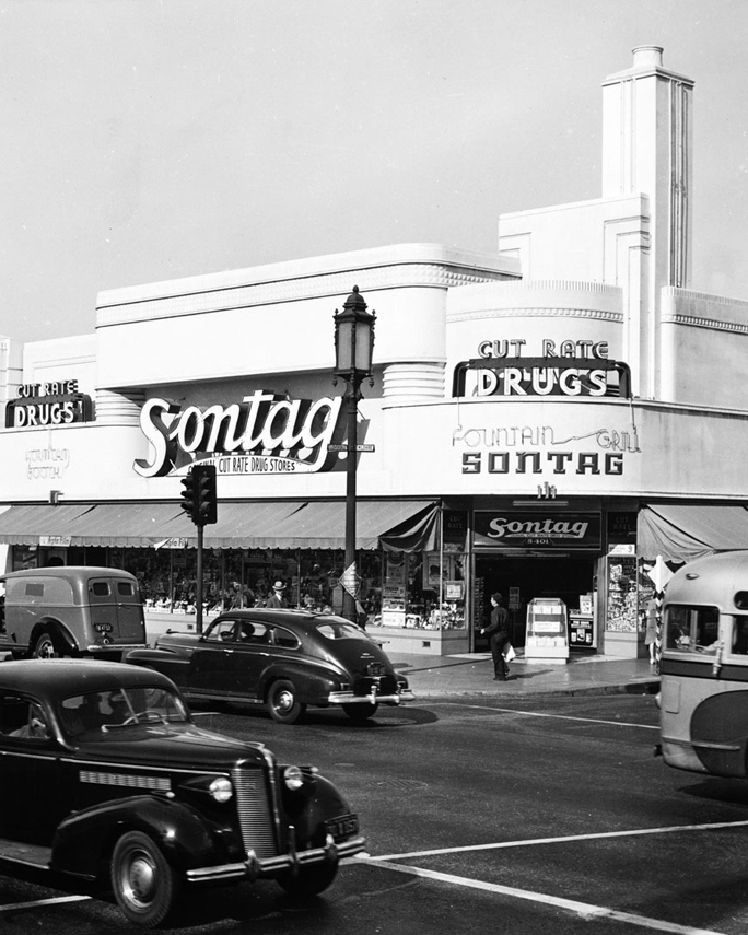
| (1939)^ - View looking west from the corner of Wilshire Boulevard and Cloverdale Avenue. The Art Deco building housing a Sontag Drug Store is seen on the corner. A&P Food Palace is seen futhrer west. |
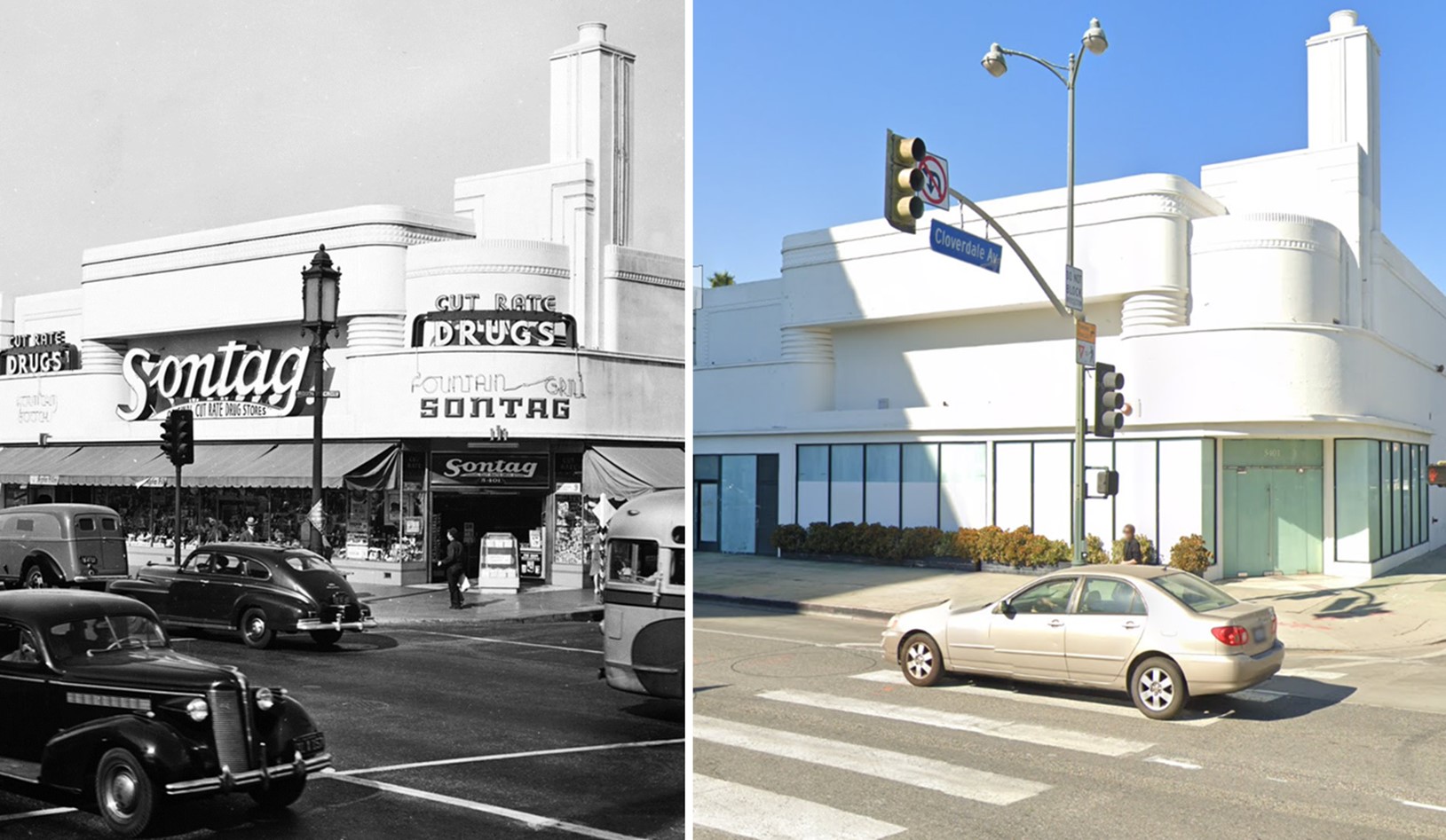
Historical Notes Built in 1935, this Art Deco structure has stood the test of time. It was originally the Sontag Drug Store, one of the largest drug stores in America at the time. It was also one of the first to allow customers to browse and choose their own products rather than requesting them from a clerk behind a counter. |
 |
|
| (1941)* - View showing Sontag Drug Store, located at the northwest corner of Wilshire Boulevard and Cloverdale Avenue. |
Historical Notes The Art Deco building still stands, housing “Wilshire Beauty" (as of 2021) and looking much like it did more than seven decades ago. Click HERE to see contemporary view. |
Then and Now
 |
|
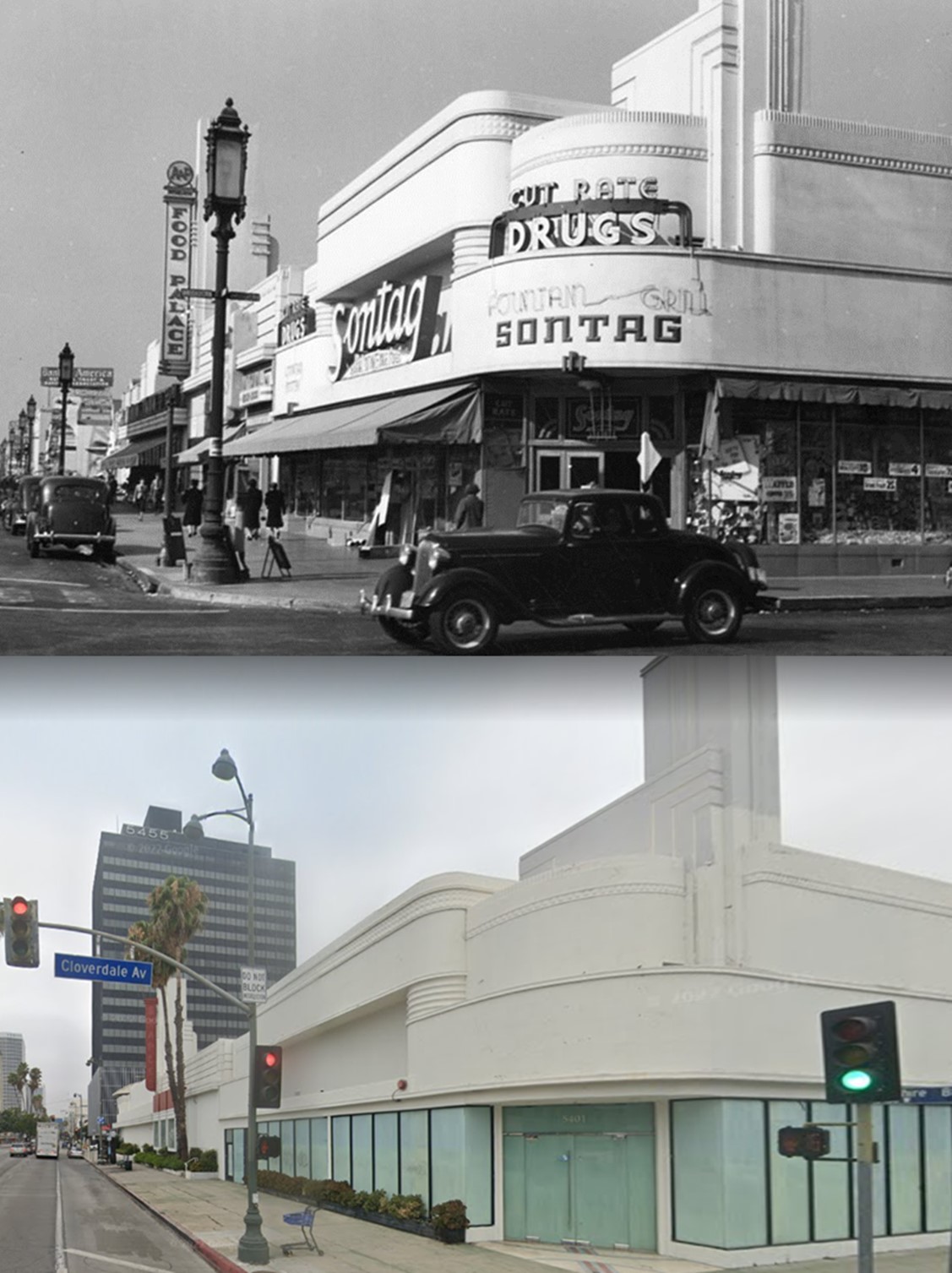
| (1939 vs 2022)* - Looking at the NW corner of Wilshire and Cloverdale showing the Art Deco Building that housed a Sontag Drug Store as early as 1935. |
Then and Now
 |
|
| (1941 vs 2023)* - Looking at the NW corner of Wilshire and Cloverdale showing the Art Deco Building that housed a Sontag Drug Store as early as 1935. |
.jpg) |
|
| (ca. 1940)*# – View looking east along Wilshire Boulevard with the E. Clem Wilson Building at La Brea and Wilshire in the background. The Dominguez-Wilshire Building is on the right. Sontag Drug Store is on the left. |
 |
|
| (ca. 1939)* – Moving closer toward La Brea on Wilshire Boulevard with the E. Clem Wilson Building seen on the NE corner. |
Then and Now
 |
|
| (1939 vs 2022)* – Looking east on Wilshire Blvd toward La Brea Ave on LA's Miracle Mile. |
Wilshire and La Brea
 |
|
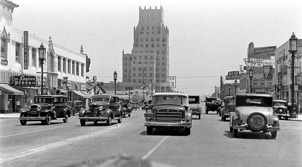
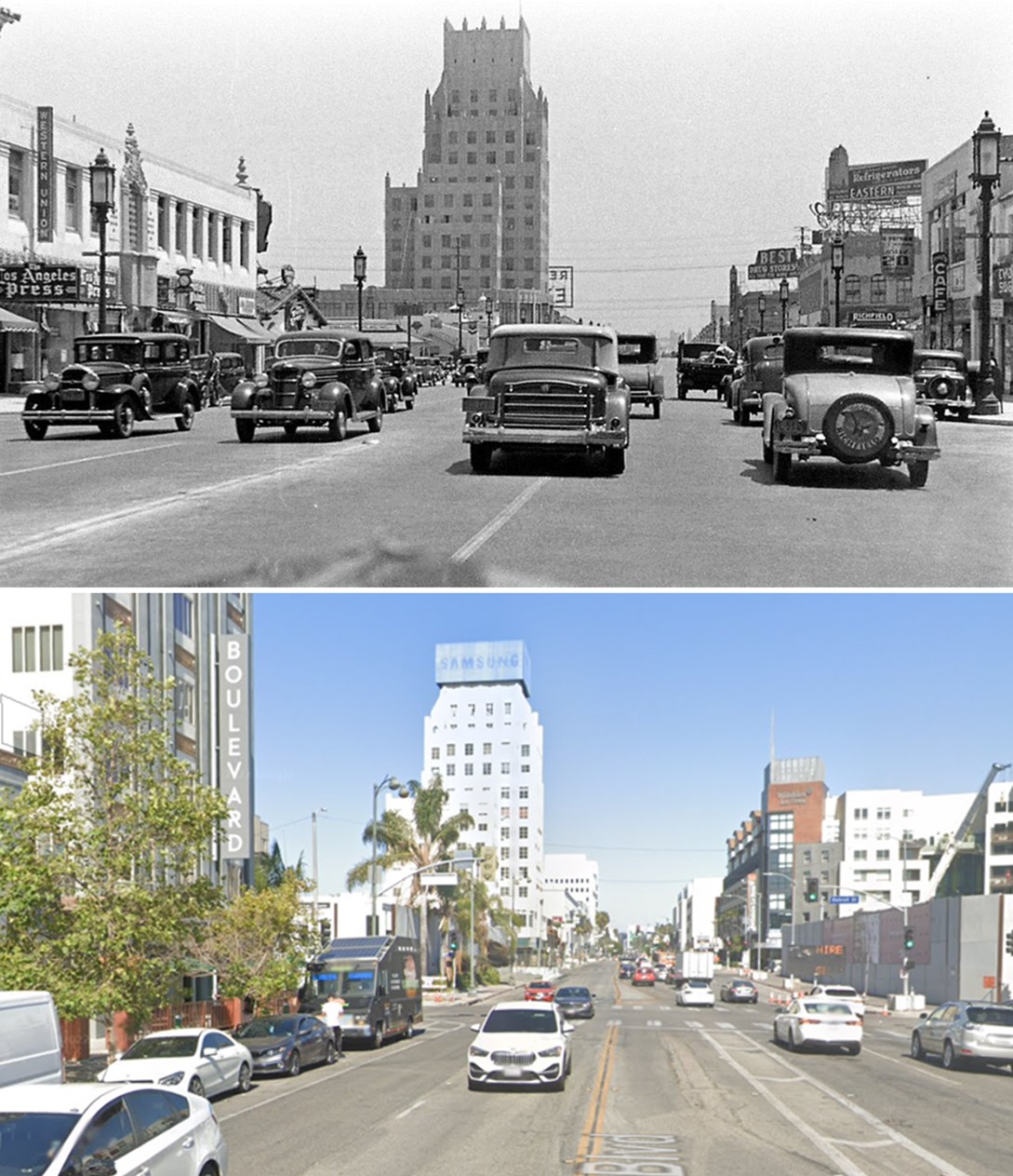
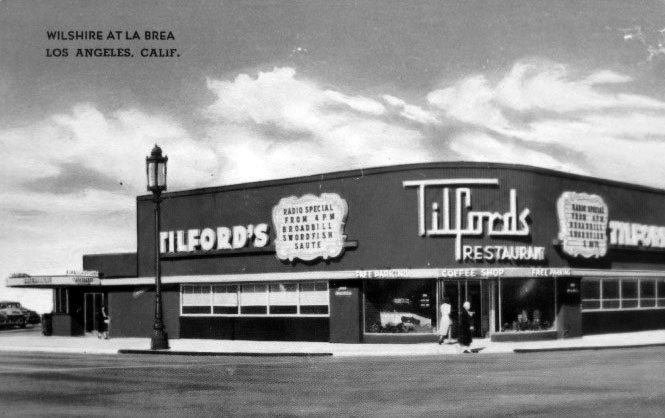
| (ca. 1949)* - Looking northeast at Wilshire Boulevard and La Brea Avenue showing Tilford's Coffee Shop on the left (NW corner), a city bus advertising Kaye-Halbert television sets and a beautiful 1941 'Parma Wine' Pontiac two-door torpedo. The E. Clem Wilson Building is on the right. |
 |
|
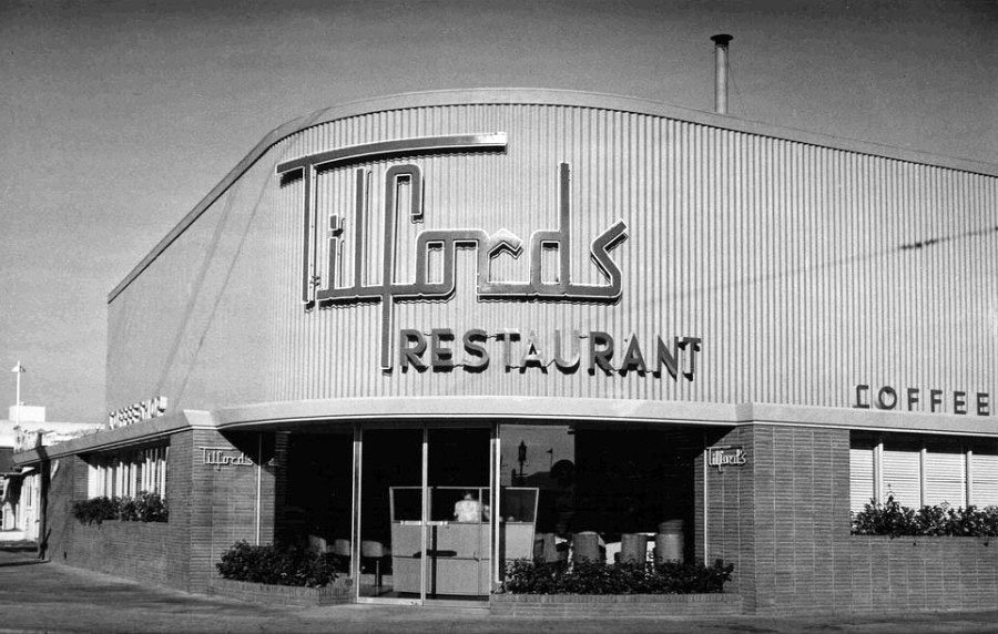
| (ca. 1960s)^ - View showing Tilford’s Restaurant and Coffee Shop, located at the northwest corner of La Brea Avenue and Wilshire Boulevard. Photo courtesy of the Miracle Mile Residential Association |
Historical Notes Tilford’s Restaurant and Coffee Shop was designed by Los Angeles architect Welton Becket and opened in 1949. Welton Becket is best known for designing the LAX Theme Restaurant, the Capitol Records Building, Parker Center and other notable Los Angeles landmarks. Tilford's replaced Dyas-Carleton Café that stood on this corner since 1928. |
 |
|
| (1950s)^ - Postcard view of Tilford’s Restaurant and Coffee Shop. The understated elegance of its original design has been hidden by a garish paint job and out of character signage. Photo courtesy of the Miracle Mile Residential Association |
Historical Notes Metro purchased the property in 1984 and converted it into a Metro Customer Center, which stood vacant for many years before being demolished. It will soon become the location of the La Brea/Wilshire portal of the Purple Line subway extension. |
 |
|
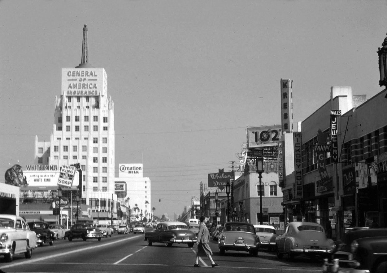
| (1954)^ - Looking east on Wilshire at the E. Clem Wilson Building at La Brea and Wilshire. Sign on building reads: General of America Insurance. The Carnation Building is seen in the distance. |
Historical Notes Because of its height and prime location on the northeast corner of Wilshire and La Brea, the Art Deco E. Clem Wilson Building has attracted prominent signage over the years. Corporate names that adorned The Wilson Building included (in chronological order): General Insurance, Mutual of Omaha (until 1990), Asashi, and Samsung. |
 |
|
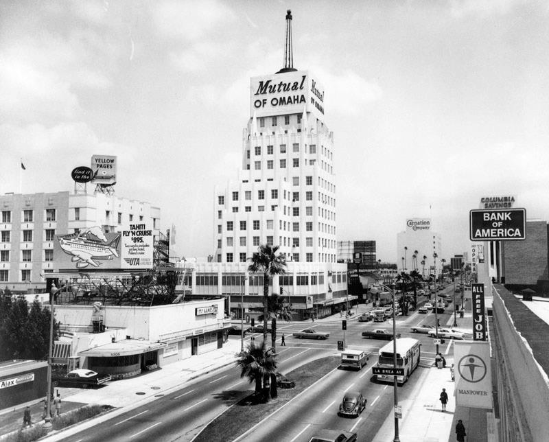
| (ca. 1975)^ - Exterior view of the E. Clem Wilson Building, looking east on Wilshire toward La Brea Ave. The sign on the building reads: "Mutual of Omaha" |
Historical Notes Corporate names that adorned The Wilson Building included (in chronological order): General Insurance, Mutual of Omaha (until 1990), Asashi, and Samsung. |
 |
|
| (1957)* - Aerial view looking east along the ‘Miracle Mile’, Wilshire Boulevard between Fairfax and La Brea. Near the top-center can be seen the E. Clem Wilson Building (NE corner of Wilshire and La Brea). The next large building east of La Brea is the Carnation Building. Coulter's Department Store can be seen at lower right (SW corner of Wilshire and Hauser). |
Historical Notes Strictly speaking, the term “Miracle Mile” applies to the section of Wilshire Boulevard between Sycamore Avenue, which runs just east of La Brea Avenue, and Fairfax Avenue, which forms the district’s boundary to the west. However, and not unusually for Los Angeles, where geographic terminology is not always precise, Miracle Mile connotes a larger geography. Sometimes it incorporates the section of Wilshire Boulevard stretching east of La Brea all the way to Highland Avenue. ^^ |
Wilshire near Highland
 |
|
| (1950)^ – View looking west on Wilshire Boulevard toward La Brea Avenue as seen from Citrus Avenue (right). Several significant buildings can be seen in the distance. From left to right: Four Star Theatre, Fox Ritz Theatre, Dominguez-Wilshire Building, and the E. Clem Wilson Building (NE corner of Wilshire and La Brea). The Carnation Building is to the right (out of view). |
 |
|
| (ca. 1962)^ – View looking at the southwest corner of Wilshire and Mansfield Ave showing the Four Star Theatre. Coincidentally, the theater is showing “The Four Days of Naples”. A Dutch Boy Paint Store occupies the corner space of the Art Deco building with a huge roof-mounted billboard advertising Buick. Note the dual-lamp streetlight on the corner |
Historical Notes In the mid-1950s the ornate 1928-installed streetlights along Wilshire Boulevard (called Wilshire Special), running from Fairfax Avenue to beyond Wilton Place, were replaced by a newer, higher efficient, two headed streetlight (referred to as the Wilshire Double). |
 |
|
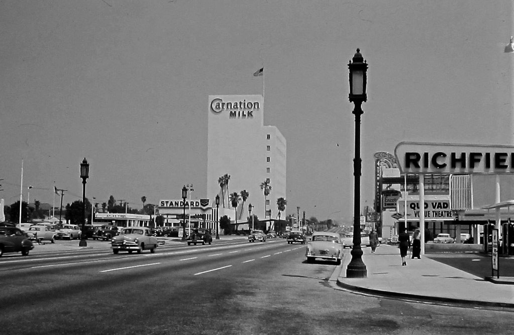
| (ca. 1951)^ – View looking east on Wilshire Boulevard from Orange Drive showing the Carnation Building in the distance. At right, the Four Star Theatre can be seen behind the Richfield sign. |
Historical Notes This stretch of the eastern end of the Miracle Mile has seen dramatic change with building construction. Click HERE to see this same view in 2009. HERE's the same view in 2017. |
 |
|
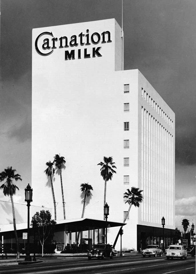
| (ca. 1949)^ – View showing the Carnation Building and adjacent Carnation Coffee Shop located on the north side of Wislhire between Mansfield and Citrus. Bob's Big Boy was on the south side of Wilshire, right across the street from Carnation. The former Big Boy is now the home of Beverly Hills BMW and the adjacent movie theater was the Four Star, which became a church. |
Historical Notes In 1948, the Carnation Company hired Beaux-Arts educated architect Stiles O. Clements (1883-1966) to design its new corporate headquarters on Wilshire Boulevard in Los Angeles. The company decided to maximize on the high percentage (30%) of its employees living in California. Staff in Seattle, Milwaukee and New York were relocated and former branch operations such as accounting, advertising and purchasing were centralized. ^ Click HERE to see more early views of the Carnation Building and Coffee Shop. |
 |
|
| (1952)* – View looking east on Wilshire Boulevard as seen from the Carnation Building, after a storm. Citrus Avenue runs horizontally at bottom of photo. A Signal Gas Station is seen on the northeast corner of Wilshire and Highland Avenue. Click HERE for contemporary view. |
 |
|
| (ca. 1958)^ – View looking west on Wilshire Blvd toward La Brea Ave. |
 |
|
| (2015 )^ – ‘Miracle Mile’ looking west from just east of La Brea Avenue. |
 |
|
| (1950s)* – View of the Miracle Mile neon sign at Wilshire and La Brea with the General of America Insurance Building standing tall in the background. |
Historical Notes Eventually, the Miracle Mile was overwhelmed by the same forces of change that once made it a success. Increasing reliance on the personal automobile and uncontrolled sprawl ushered in the age of suburban shopping malls, which challenged older, automobile-oriented retail districts like the Miracle Mile just as the Miracle Mile had previously challenged the pedestrian-oriented retail district downtown. Unable to compete, retailers once at the vanguard of L.A's decentralization relocated, leaving vacant storefronts and shabby discount stores in their place. By the 1980s, the mile-long stretch of Wilshire Boulevard was in need of a second miracle. Even the president of the Miracle Mile Residential Association compared the area to "a slum." Representing local residents, he called on the city to declare the Miracle Mile a historic district, hoping the designation would spur revitalization and attract interest in the area's many elegant Art Deco and Streamline Moderne structures. But property owners rejected the call, and despite preservationists' protest, many cherished buildings have since fallen to make way for apartment complexes. Instead, it was museums and office centers that injected new life into the Miracle Mile. Patrons flocked to the Los Angeles County Museum of Art (LACMA), which had moved to Hancock Park in 1965. Across the street, the former Orbach's department store found new life in 1994 as the Petersen Automotive Museum, and four years later the abandoned May Company building at Fairfax and Wilshire reopened as LACMA West.^ |
 |
|
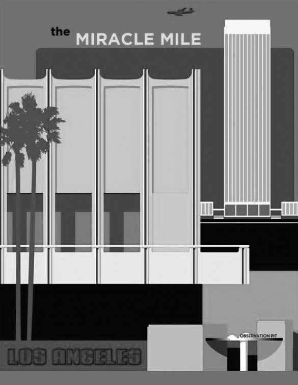
| (2019)^ – Contemporary poster of the Miracle Mile. Courtesy of Henry Briceno |
Historical Notes With LACMA, the Petersen, and other museums – including the Craft and Folk Art Museum, the Page Museum at the La Brea Tar Pits, and the Architecture and Design Museum – the Miracle Mile has gained a reputation today as L.A.'s museum row. Meanwhile, publications like Variety, The Hollywood Reporter, and Los Angeles Magazine now call the district home. While the Miracle Mile can no longer claim to be the city's premier retail district, the area once derided as "Ross' bean patch" remains fertile commercial ground.^ |
Click HERE to see Earlier Views of the Miracle Mile (1920s & 1930s). |
* * * * * |
Please Support Our Cause Water and Power Associates, Inc. is a non-profit, public service organization dedicated to preserving historical records and photos. Your generosity allows us to continue to disseminate knowledge of the rich and diverse multicultural history of the greater Los Angeles area; to serve as a resource of historical information; and to assist in the preservation of the city's historic records. |
For more Historical Los Angeles Views click one of the following:
For Other Historical Views click one of the following:
See Our Newest Sections:
To see how Water and Electricity shaped the history of Los Angeles click one of the following:
Water:
Power:
* * * * * |
References and Credits
* DWP - LA Public Library Image Archive
^ LA Public Library Image Archive
*^Oviatt Library Digital Archives
^^LA Times: Photo Archive; An Oil Well on La Cienega; Mulholland Bridge; A Mountain of Red Cars; The Vincent Thomas Bridge; Hill Street Tunnels; Harbor-Santa Monica Freeway Interchange; Dodgers Caravan,1958
#*MTA Transportation and Research Library Archives
+#Facebook.com: Garden of Allah Novels
#^^Picturetrail.com: KCET - Angels Flight
#^*Downtown LA Public Art: Fort Moore Pioneer Monument
^**Flickr: Enock 1; Eric Richardson
*^#Los Angeles Conservancy: LA Stock Exchange Building; Park La Brea
^#^Pacific Electric Railway Historical Society - Alan Weeks Collection
*#*Westland.net: Venice History
*#^Forum.Skyscraper.com: Arroyo Seco Library; Westwood-Life Magazine; North Los Angeles Street
^#*Metro.net: Mulholland Drive Bridge
**#The California History Room, California State Library: William Reagh
#**Pinterest - California and DailyBreeze.com
#^#Deadhistoryproject.com: Silent Movie Theater
+**Los Angeles' Bunker Hill - Alta Visa Apartments
+##MartinTurnbull.com: Fairfax and Wilshire
^^+How Stuff Works: Chevrolet Impala
+#+Pinterest - California and DailyBreeze.com; Mid Century Hollywood
++#Facebook.com: Photos of Los Angeles
^^#The George A. Eslinger Street Lighting Photo Gallery
^^*Early Downtown Los Angeles - Cory Stargel, Sarah Stargel
***Los Angeles Historic - Cultural Monuments Listing
*^*California Historical Landmarks Listing (Los Angeles)
*^^Nuestra Señora la Reina de los Ángeles: losangelespast.com
**** Pinterest.com: Los Angeles Dodgers; Los Angeles and Hollywood; MacArthur Park w/Downtown Skyline; Gilmore Self-Service Gas Station
**^*California State Library Image Archive
**^#Vintage Los Angeles: Facebook.com - Gilmore Stadium and Field; Cruising Hollywood Blvd
^^^^Depaul.edu: Night Train 55
**#^Vincent Thomas Bridge - Facts and Figures
*#**Flickr-Los Angeles in Good Light - Ron Reiring
^#^^Flickr.com: Michael Ryerson
*#^#Life.time.com: Stoked-Life Goes Surfing
*#*#Abandoned & Little-Known Airfields – Paul Freeman
^#*#LA Magazine: Beverly Park Ponyland
^^##Pacific Electric Railway Historical Society
^^*#Historic LA Theatres: Downtown Broadway Theatres
^^#*LA Observed.com: Decommissioned Street Cars; Bunker HIll, 1964
*^^*Pinterest.com: Bertrand Lacheze
^^**Pinterest.com: Vintage California
^^++Huntington Digital Library Archive
*##*Pinterest.com: Trucks, Pick-Ups, and Gas Stations
*##^LAist.com: Harbor Freeway, 1969; Century Plaza Hotel
##*^Port of Los Angeles: portoflosangeles.corg
##^*Calisphere: University of California Image Archive
##^^Cinema Treasures: Olympic Drive-In
#**#California State University Northridge History: csun.edu
#++#The Pacific Electric Railway Historical Society (PERyHS)
#*##Daily News: Mulholland Bridge
#^**The Go Go's: N/W Corner of Hollywood and Vine
#^*#Flickr.com: Paul Bajerczak
##^#Facebook.com: Classic Hollywood-Los Angeles-SFV
^***UCLA Library Digital Archive
^^^*KCET: Welcome to L.A. River; Four Level Interchange; Construction of 5 Southern California Freeways; Beverly Park and Ponyland; Before the 'Carmageddon': A Photographic Look at the Construction of 5 SoCal Freeways; Seventh and Broadway; L.A.'s First Freeways
****^Facebook.com: West San Fernando Valley Then And Now
*^^^^Los Angeles Maritime Museum
^^^**tumblr.com: John Ferraro Office Building; DWP Office Building
**^^^Facebook.com - San Pedro's Original Website, San Pedro.com
#*#**Facebook.com: Beverly Park - L.A.'s Kiddieland
**#**LMU Digital Archive
**^ Noirish Los Angeles - forum.skyscraperpage.com; Westwood-Life Magazine; Selling Papers on Olive; California Federal Plaza Building; Downtown Aerial 1958; 1949 Construction of 101 Freeway; 1953 Harbor Freeway Construction; Wilshire Blvd, 1949; Zephyr Room and Brown Derby Postcard View; Aliso Before and After 101 Frwy; Vincent Thomas Bridge; Gilmore Aerial; Hollywood Frwy Traffic Jam; 2012 Downtown Skyline; View from GOB; Bonaventure Hotel Aerial; Hollywood and Vine
^* Wikipedia: Hollywood Sign; Carthay Circle Theatre; Fairfax High School; Park La Brea; San Vicente Boulevard; Etymologies of place names in Los Angeles; Los Angeles Central Library; Broadway Tunnel; Pershing Square; Pacific Electric Railway; Gilmore Field; GilmoreStadium; Union Station; Westwood; 6th Street Viaduct Bridge; Figueroa Street Tunnels; Chavez Ravine; 2nd Street Tunnel; Hollywood Freeway; Los Angeles International Airport; Los Angeles City Hall; Wilshire Boulevard Temple; Egyptian Theatre; The Pig 'N Whistle; Sunland-Tujunga; Van de Kamp Bakery Building; Los Angeles County Art Museum; Los Angeles City Oil Field; Los Angeles Railway; Miracle Mile; Interstate 405; Chevrolet Impala; Playa Vista; Harbor Frwy (Interstate 110); History of Los Angeles Population Growth; Los Angeles City Hall Lindbergh Beacon; May Company California; Four Level Interchange; California Federal Bank; Harbor Freeway; Arroyo Seco Parkway; Brown Derby; 2004 Los Angeles Skyline; LA's Oldest Palm Trees; Vincent Thomas Bridge; World Cruise Center; CSUN; Westwood; Westwood Village; UCLA; History of UCLA; 1950s Americal Automotove Culture; Pershing Square; Century Plaza Hotel; California Incline
< Back