Early Views of Wilshire and Fairfax
Introduction |
The intersection of Wilshire Boulevard and Fairfax Avenue is one of the most storied corners in Los Angeles. Today it anchors a dense urban landscape of museums, high-rises, and transit lines. But for much of the early twentieth century it was a wide-open expanse of oil derricks, bean fields, airstrips, and slowly widening roads. The story of this corner is in many ways the story of Los Angeles itself, a city that remade its landscape with remarkable speed and boldness, turning extraction into commerce and open land into one of the great urban boulevards of the American West.The land around Wilshire and Fairfax was shaped first by oil. When dairy farmer Arthur Fremont Gilmore struck petroleum on his property near Third Street and Fairfax Avenue around 1903, he set off a rush of exploration that spread derricks across the district. The Salt Lake Oil Field, as the area came to be known, reached its peak production around 1908, with more than 450 wells eventually drilled across the flats. By the late 1910s production was falling and land values were rising. The same forces that had drawn drillers to the district now attracted developers, retailers, and real estate speculators with ambitions for what this open frontage might become.The photographs in this section trace that transformation across roughly two decades, from the aerial views of 1920 that show Chaplin Airfield and DeMille Field occupying the very ground where department stores and drive-in restaurants would later stand, to the late 1930s when double-decker buses ran along a widened and paved Wilshire and construction cranes announced the arrival of the May Company. Taken together they document a moment in the life of a city when almost everything was still possible and almost nothing had yet been decided. |
Oil Fields and Air Fields |
When Derricks and Biplanes Shared the Same Ground |
The earliest photographs of the Wilshire and Fairfax district show a landscape defined by oil and aviation, two industries that briefly shared the same open ground before either gave way to the city growing up around them. Oil derricks dotted the fields in every direction while, just yards away, biplanes taxied past crowds of spectators who had driven out from Hollywood and downtown for the novelty of watching machines take flight. It was an unlikely combination, but it captured something essential about Los Angeles in the early 1920s: a place where the future arrived in overlapping waves, each one briefly visible before the next one washed it away. |
 |
|
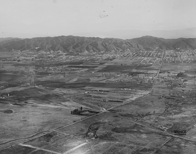
| (1922)* - Aerial view looking northwesterly showing Crescent Avenue (later Fairfax Avenue) running diagonally from lower-left to center-right, where it crosses Wilshire Boulevard and bends northward toward the Hollywood Hills. San Vicente runs diagonally from lower-right to upper-left. Oil wells are scattered across the open land that would become the Miracle Mile within a decade. |
Historical Notes By 1922 the Salt Lake Oil Field had passed its peak production years, but derricks still dominated the view from the air. The field took its name from the Salt Lake Oil Company, the first firm to begin drilling in the area, with the discovery well spudded in 1902. Production spread rapidly across the landscape, reaching more than 450 wells by 1917 and yielding upward of 50 million barrels before declining steeply. As output fell, land values rose with the expanding city, and the question of what to do with the former oil district began to attract the attention of real estate developers. The diagonal street visible in this image as Crescent Avenue would be renamed Fairfax Avenue in recognition of the Fairfax family, Virginia planters with whom George Washington had personal ties. The name had been attached to the surrounding district since the late nineteenth century. San Vicente, cutting across the lower portion of the frame, follows the alignment of a Pacific Electric Railway line that would later become the roadway seen there today. Almost nothing in this photograph suggests the commercial boulevard and cultural corridor that would emerge here within a decade. |
 |
|
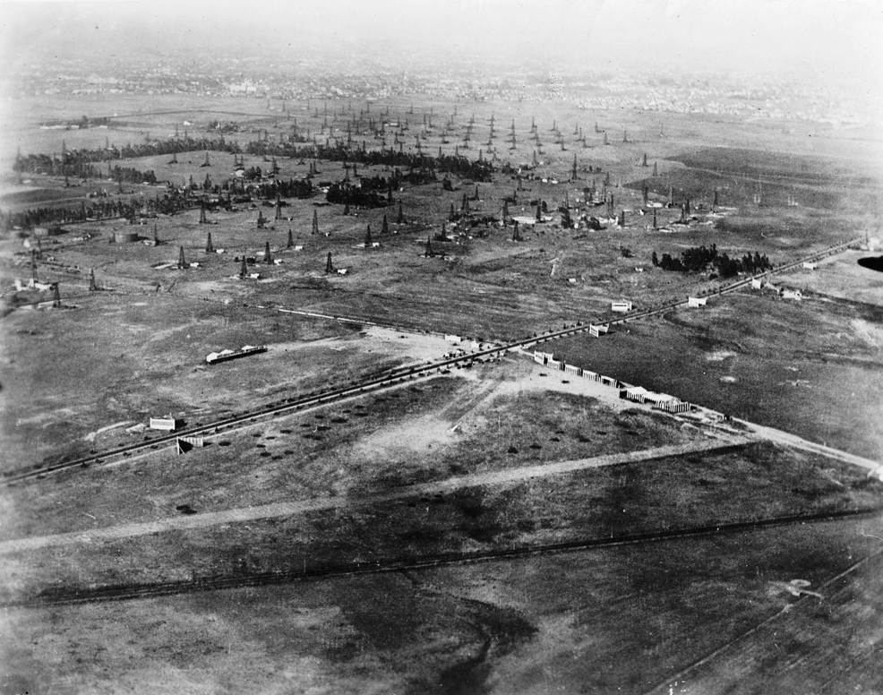
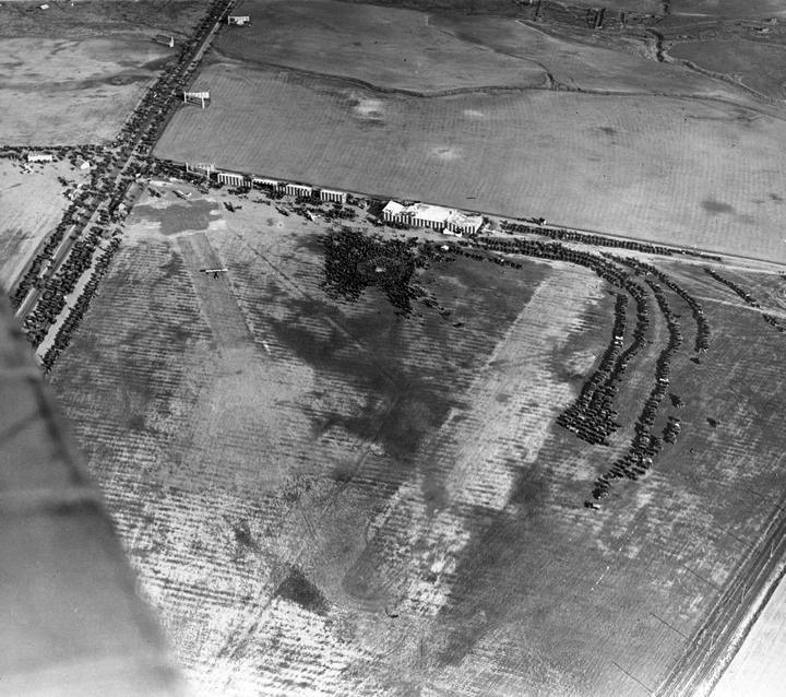
| (1920)* - Aerial view of Crescent Avenue (now Fairfax) and Wilshire Boulevard showing undeveloped land with many oil derricks. In the lower part of the photograph is Chaplin Airfield. The tree-lined street is Wilshire. The diagonal line at the bottom follows the Pacific Electric Railway tracks that would later become San Vicente Boulevard. |
Historical Notes The Fairfax District was little more than bean fields and dairy land at the turn of the century when Arthur Fremont Gilmore set out to dig a well on his 256-acre farm near Third Street and Fairfax Avenue. Instead of water, he struck oil. His discovery is credited with prompting an exploration boom that spread derricks across the surrounding flats, a region that came to be known as the Salt Lake Oil Field. The Gilmore family would go on to transform their holdings into one of the most recognizable commercial properties in the city, including the original Farmers Market established in 1934 at Third and Fairfax. Also visible in this photograph, just below the tree-lined strip of Wilshire, is the early footprint of Chaplin Airfield. The open, unpaved ground southwest of the intersection served as a landing and takeoff strip for the Syd Chaplin Aircraft Corporation beginning around 1919. The diagonal line at the bottom of the frame follows the tracks of the Pacific Electric Railway's San Vicente line, which provided a reference point for the street grid that would eventually define the neighborhood. The contrast between industrial extraction, nascent aviation, and the beginnings of a real street is visible in a single frame. |
 |
|
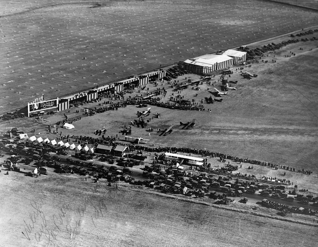
| (1920)* - Aerial view looking southeast showing crowds at Syd Chaplin's airfield at the southwest corner of Wilshire Boulevard and Crescent Avenue (now Fairfax Avenue). Dozens of cars are parked in rows in the foreground with several aircraft parked in the open field behind them. A vendor tent and additional parked cars are visible farther up. A billboard at left reads "Racine Tires." |
Historical Notes Chaplin Airfield was established in 1919 by Sydney Chaplin, the older half-brother of Charlie Chaplin. The airfield occupied leased property bounded by Wilshire Boulevard, Fairfax Avenue, and San Vicente Boulevard at the southwest corner of the intersection. The Syd Chaplin Aircraft Corporation advertised a fleet of Curtiss one- and two-passenger aeroplanes along with hangars and maintenance facilities for private owners. Observation flights were priced at ten dollars, while a round trip to San Diego could be had for $150, at a time when the average annual wage was around $1,200. The crowds visible in this photograph reflect the genuine public enthusiasm for aviation in these early years. Air shows drew spectators who had never seen a plane in flight and who drove out to the open fields west of the city for the spectacle. The financial realities proved harder. With such steep ticket prices relative to average wages, Chaplin's enterprise could not sustain itself on passenger revenue alone. By around 1921, Chaplin sold his interest to a business partner named Emory H. Rogers, who renamed the operation Rogers Field. The airfield's brief life ended as the surrounding land became too valuable for any use other than commercial development. |
 |
|
| (2023)* – Google Earth view looking down at the area southwest of Wilshire and Fairfax, where Syd Chaplin's airfield once stood. The open ground that once served as runway and parking is now fully built out with streets and residential structures. Photo comparison by Jack Feldman. |
Historical Notes This overhead view places the original footprint of Chaplin Airfield in the context of the modern city. The open ground that once accommodated rows of parked automobiles and fabric-winged biplanes is now covered by a dense grid of streets, apartment buildings, and commercial structures extending south from Wilshire. Nothing visible on the surface suggests that aircraft once took off and landed here or that crowds gathered on summer afternoons to watch early exhibition flights. The transformation from airfield to urban neighborhood took place over roughly a decade following the closure of Rogers Field in the early 1920s. As Wilshire Boulevard was widened, paved, and lined with commercial buildings through the late 1920s and 1930s, the surrounding parcels were subdivided and developed. The Google Earth view documents the end result of that process: a landscape so thoroughly rebuilt that the earlier one is entirely invisible without the historical record. |
Then and Now
 |
|
| (1920 vs. 2023)* - A then and now aerial comparison showing the original Chaplin Airfield at the southwest corner of Wilshire and Fairfax and how the same ground has evolved over a century. Photo comparison by Jack Feldman. |
Historical Notes Seen top and bottom, the 1920 aerial and the contemporary overhead view illustrate how completely this corner of Los Angeles was remade in the course of a single century. The upper image shows open ground, scattered derricks, and the informal geometry of a landing field. The lower image shows a dense, fully built urban environment where the original features have left no visible trace. The comparison also illustrates the speed of that change. By the late 1920s, just a decade after Chaplin Airfield opened, real estate developer A.W. Ross was already assembling parcels along Wilshire Boulevard for what he envisioned as a new kind of commercial district aimed at the motoring public. His vision became the Miracle Mile. Within another decade, the open oil fields visible in 1920 had been replaced by department stores, restaurants, and some of the most architecturally distinctive commercial buildings in the city. The airfield itself left no landmark, only a memory preserved in historical photographs. |
 |
|
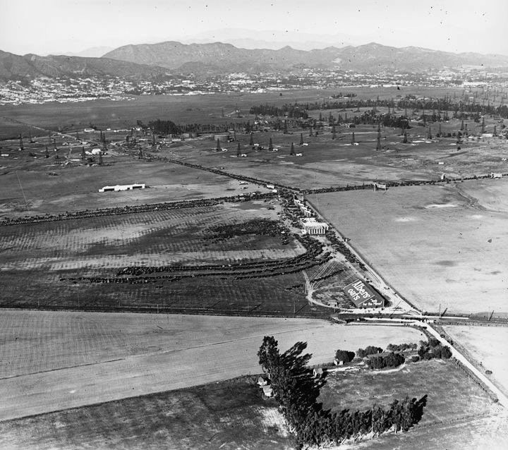
| (ca. 1922)* - View looking north shows numerous cars parked on a lot (center of photo) near the airfield as well as along Wilshire Blvd. and Crescent Ave (Fairfax). Large sign on building in the lower-right center at the intersection of Fairfax and the San Vicente line of the Pacific Electric Railway reads: Albers Oats. |
Historical Notes The Salt Lake Oil Field reached peak production around 1908 and declined steadily in the years that followed. As output fell and land values rose, many wells were abandoned and their locations gradually disappeared beneath streets and new construction as the city expanded westward. The Albers Oats sign at the Pacific Electric stop at Fairfax and San Vicente reflects the area’s early role as a modest commercial node. The San Vicente line carried passengers through a landscape where oil production, aviation, and early street development existed side by side. The scene captures a transitional moment when several future uses of the land overlapped before giving way to permanent urban development. |
 |
|
| (ca. 1922)^ – Aerial view looking down at the Chaplin Airdrome with the intersection of Crescent Avenue(later renamed Fairfax) and Wilshire Boulevard seen in upper-left. |
Historical Notes The Chaplin Aircraft Company offered observation flights for $10 and round-trip flights to San Diego for $150 at a time when the average annual wage was approximately $1,200. The cost of air travel placed it well beyond the reach of most Angelenos, and the enterprise had a brief commercial life. Around 1921, Chaplin sold out to Emory H. Rogers, a business partner, who renamed it Rogers Field. Rogers combined the former Chaplin property on the southwest corner of Wilshire and Fairfax with the adjacent DeMille Field No. 2 on the northwest corner to create a larger operation that straddled the boulevard west of Fairfax. The airdrome visible in this photograph shows the utilitarian simplicity of early aviation facilities: cleared ground, a few hangars, and the informal infrastructure of a working airfield. The proximity to oil derricks and open agricultural land underscores how undeveloped the district remained even as the city around it was growing rapidly. Within just a few years, this same ground would be occupied by some of the most fashionable commercial buildings in Los Angeles. |
 |
|
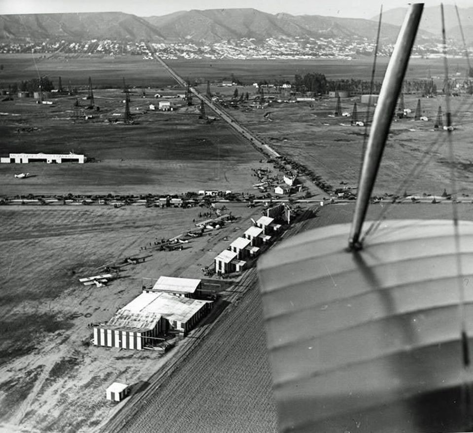
| (ca. 1922)* - View looking north over the wing of a bi-plane showing the intersection of Crescent Ave (Fairfax) and Wilshire Blvd. A crowded airfield (now Rogers Airfield) is seen below. In the distance oil derricks are seen at Fairfax Avenue where 6th Street is located today. In the far background, at the foothills, can be seen a built-up Hollywood. |
Historical Notes Cecil B. DeMille was among the most prominent figures in early Los Angeles aviation. In 1918 he founded the Mercury Aviation Company and established DeMille Field No. 1 near Melrose and Fairfax, then moved operations to a larger second facility, DeMille Field No. 2, on the northwest corner of Wilshire and Fairfax. Mercury Aviation flew surplus World War I Curtiss JN-4 Jennies for sightseeing and charter work. In August 1920, World War I flying ace Eddie Rickenbacker delivered the company's first factory-new aircraft to the field. The following year, Mercury launched regularly scheduled passenger service to Catalina Island, San Diego, and San Francisco, making it one of the earliest commercial airlines in the country. By 1922, both the former Chaplin Airfield on the southwest corner and DeMille Field No. 2 on the northwest corner had passed into the hands of Emory H. Rogers, who combined them under the name Rogers Airfield. Despite the ambitions of its founders, commercial aviation at this location was short-lived. Mercury Aviation closed in 1922, unable to sustain profitability. Rogers Airfield carried on briefly before the economic pull of real estate development made the land too valuable for any other purpose. The view from the cockpit in this photograph captures that moment: an operating airfield surrounded on all sides by a city in the process of becoming something different. Click HERE to see more in Aviation in Early Los Angels. |
 |
|
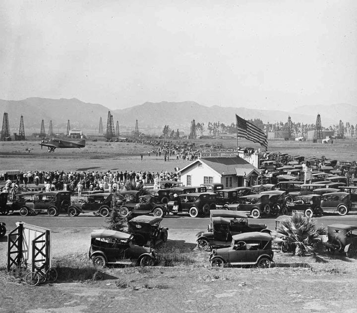
| (1920s)* - Parking lot is full as crowds attend air show at DeMille Field No. 2. The sign on top of the structure with the large American Flag reads: DeMille Field No. 2. View is looking northeast near the NW corner of Wilshire and Fairfax. In the background can be seen oil derricks and on the right (out of view) are the La Brea Tar Pits. |
Historical Notes DeMille Field No. 2 drew large crowds for air shows and exhibitions throughout the early 1920s. Aviation was still new enough that watching a biplane take off and land was a genuine spectacle, and the open fields west of the city provided a natural gathering place for audiences arriving by automobile from across the region. Cecil B. DeMille also used the field for motion picture productions, filming aerial sequences for his silent films. In August 1920, two stunt pilots, Ormer Locklear and Milton Elliott, were killed at the field while filming a night sequence for The Skywayman, bringing the site national attention. The full parking lot in this photograph reflects both the popularity of these events and the growing role of the automobile in shaping how Angelenos traveled to entertainment. The large American flag above the DeMille Field sign reflects the patriotic associations that aviation carried in the years following World War I, when many planes were surplus military aircraft and many pilots were veterans. Within a few years, both the airfields and most of the oil operations would give way to the commercial buildings and paved streets of the Miracle Mile. |
 |
|
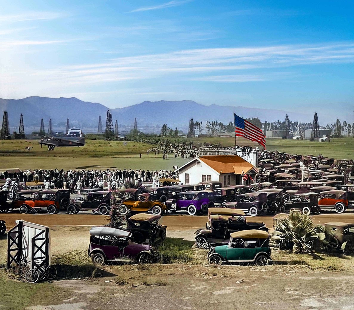
| (1920s)* - Parking lot is full as crowds attend air show at DeMille Field No. 2. The sign on top of the structure with the large American Flag reads: DeMille Field No. 2. View is looking northeast near the NW corner of Wilshire and Fairfax. In the background can be seen oil derricks and on the right (out of view) are the La Brea Tar Pits. Image enhancement and colorization by Richard Holoff |
Historical Notes The colorized version of this photograph adds visual depth to the scene, making the scale of the crowd and the atmosphere of an air show day more apparent than in the original black and white image. Richard Holoff’s work is based on careful research into period signage, vehicles, building materials, and clothing, helping ensure that the enhanced image remains historically credible. The oil derricks visible behind the airfield remind us that aviation and oil production occupied the same landscape at the same time. While crowds gathered to watch biplanes, drilling continued nearby. Within a few years, both would give way to the commercial buildings and paved streets that defined the Miracle Mile. |
* * * * * |
Street Widening and Paving Wilshire Boulevard |
Building the Boulevard: Grading and Paving for a New Era |
Before the Miracle Mile could become a commercial destination, Wilshire Boulevard had to become a real road. Through the early 1920s, the stretch west of La Brea remained a modest two-lane passage, its surface unpaved in places and its right-of-way far narrower than what Ross and others envisioned for the district. The photographs of the 1924 paving work capture an unglamorous but essential chapter in the story: the physical construction of the boulevard that would soon attract the most fashionable retailers in Los Angeles. |
 |
|
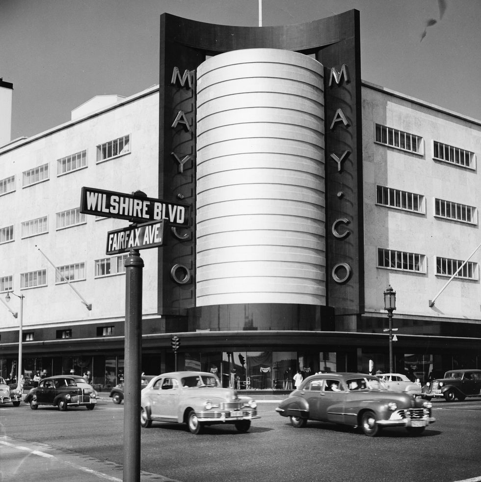
| (1924)* - View looking west on Wilshire Boulevard at Fairfax Avenue during the laying of new pavement. The Wilshire Fairfax Tract office is visible on the northwest corner. Photo courtesy of Peter Ferry. |
Historical Notes The paving of Wilshire Boulevard in the mid-1920s was part of a broader effort to reshape the western stretches of the street into a modern commercial corridor. Real estate developer A.W. Ross had begun acquiring land along Wilshire between La Brea and Fairfax in the early 1920s, and infrastructure improvements were a necessary precondition for attracting the kinds of businesses he envisioned. The Wilshire Fairfax Tract office visible on the northwest corner of the intersection was part of that development effort, marketing parcels in a district that was still largely undeveloped. The construction of a properly paved and widened boulevard transformed what had been a modest dirt and gravel road into a corridor capable of handling the automobile traffic that Ross was counting on. His vision was explicitly auto-oriented: rather than a pedestrian shopping street in the downtown tradition, Ross imagined a boulevard lined with stores that would offer parking for customers driving in from Hollywood, Beverly Hills, and across the expanding city. The pavement seen being laid in this photograph was the physical foundation of that vision. |
 |
|
| (1924)* – Contractors Peter L. Ferry and B. B. Baucus pose in front of three teams of four-mule street graders during the development of the Wilshire Fairfax Tract, now part of the Miracle Mile. Photo courtesy of grandson Peter Ferry. |
Historical Notes The four-mule grader teams seen in this photograph were standard equipment for road construction in the early 1920s. Each team pulled a blade that leveled and compacted the roadbed in preparation for paving. The work was slow and labor-intensive, requiring multiple passes to achieve a surface flat enough to support a finished road. These animal-drawn machines were transitional technology, more capable than hand grading but giving way rapidly to motorized equipment as the decade progressed. In the late 19th and early 20th centuries, mule-drawn graders had played a crucial role in opening roads across the American West, and the streets of early Los Angeles were no exception. The contractors Ferry and Baucus were engaged in the kind of infrastructure work being carried out across Los Angeles at a remarkable pace during this period. Road construction in the 1920s was not merely an engineering project but an investment in a particular vision of urban life, one organized around the private automobile and the wide boulevard. Wilshire Boulevard, with its ban on rail transit written into the municipal code at its very founding, was the clearest expression of that vision in the entire city. |
Then and Now
 |
|
| (1924 vs. 2024)* – Looking west on Wilshire Boulevard at Fairfax Avenue during active paving work in 1924 and a century later from the same vantage point. Photo comparison by Jack Feldman. |
Historical Notes Seen top and bottom, the 1924 photograph and the 2024 view show Wilshire at opposite ends of a century of transformation. The earlier image captures a construction site that would soon become one of the most significant commercial corridors in Los Angeles, surrounded by modest structures, open lots, and roadwork still in progress. The northwest corner, where the Wilshire Fairfax Tract office stood, was once the site of DeMille Field No. 2 and Rogers Airfield. The lower image reveals a fully built urban intersection with multiple lanes of traffic, multi story commercial and residential buildings on each corner, and a density of development that would have been difficult to imagine from the vantage point of a construction crew in 1924. Developer A.W. Ross recognized the potential of this intersection earlier than most. In the early 1920s, he began acquiring land along Wilshire between La Brea and Fairfax, a stretch that some observers dismissed as too far from downtown to attract serious retail investment. Ross disagreed. He foresaw a destination shopping district that relied on the automobile rather than transit to bring customers in. His judgment proved correct. By the late 1920s, what some had called Ross’s Folly was being celebrated as the Miracle Mile, a commercial district that redefined how Los Angeles thought about retail development and urban design. |
* * * * * |
Wilshire Boulevard Development |
From Oil Fields to Open Lots: The Boulevard Takes Shape |
By the late 1920s, the open oil fields and airstrips that had defined the corner of Wilshire and Fairfax just a few years earlier were giving way to commercial development. Real estate values along the boulevard had climbed steadily as Ross's vision attracted tenants and investors. The photographs from this period show a corridor in transition, with billboard-covered lots marking future construction sites and modest structures holding ground that would soon be replaced by the large-scale commercial buildings of the Miracle Mile. |
 |
|
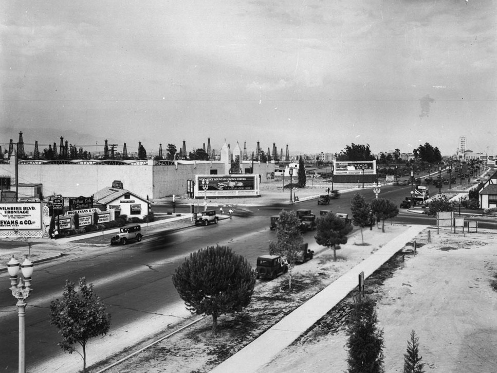
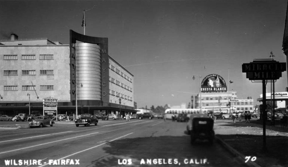
| (ca. 1929)* - Looking east on Wilshire Boulevard toward its intersection with Fairfax Avenue. The northeast corner with the billboard is where the May Company Department Store would go about ten years later. On the northwest corner where the little white house stands, Rogers Airport once operated; that site would later become the iconic circular Simon's Drive-in restaurant and is now Johnie's 50s Diner. Oil wells still dot the open ground where Park La Brea now stands. |
Historical Notes By the late 1920s, the intersection of Wilshire and Fairfax had become a highly desirable commercial address, though much of the frontage remained undeveloped. The billboard-covered northeast corner visible in this photograph would remain a construction site for nearly another decade before becoming the home of the May Company Department Store in 1940, one of the signature buildings of the Miracle Mile. The northwest corner, occupied by a modest white house where Rogers Airfield had stood just a few years earlier, would later be transformed into Simon's Drive-In, a circular structure with a tall illuminated pylon that became one of the most recognizable landmarks on Wilshire Boulevard. The open ground to the east where Park La Brea now stands was still dotted with oil wells in the late 1920s. The Salt Lake Oil Field had passed its productive peak but had not yet been fully reclaimed for other uses. The development of Park La Brea as a large-scale apartment complex began in the early 1940s, eventually replacing the last of the oil infrastructure with one of the largest housing developments of its kind west of the Mississippi. The 1929 view captures the brief interval between industrial extraction and the next phase of urban transformation. |
 |
|
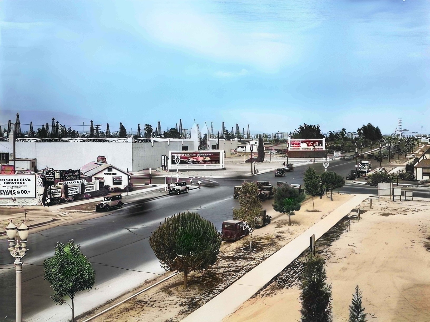
| (ca. 1929)* - Looking east on Wilshire Boulevard toward its intersection with Fairfax Avenue. The northeast corner with the billboard is where the May Company Department Store would go about 10 years later. On the opposite corner (NW corner) where the little white house is, was once Rogers Airport, and would later become the iconic circular Simon's Drive-in restaurant. It is now the Johnies 50s diner. Oil wells are spread out where Park La Brea is now. Image enhanced and colorized by Richard Holoff |
Historical Notes The colorized version of this late-1920s view gives additional texture to the streetscape, helping to clarify the relationship between the wide, newly paved boulevard and the relatively modest scale of what stood along it at the time. The billboards facing eastbound traffic on Wilshire were typical of the period, filling vacant lots with advertising revenue while owners waited for the right moment to develop. Richard Holoff's colorization work makes historical photographs more accessible to contemporary viewers by restoring the visual context that black-and-white images necessarily suppress. The colorized Wilshire views in this section have been used in historical presentations and educational contexts because they allow viewers to see a familiar boulevard in an unfamiliar form. The color of period vehicles, signs, and building materials all contribute to the sense of a living streetscape rather than a historical document, helping audiences connect more directly with a Los Angeles that existed before any of them were alive. |
 |
|
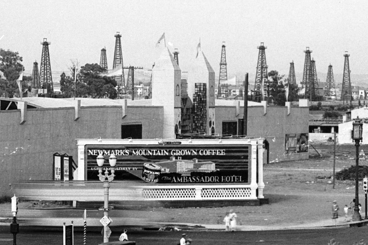
| (ca. 1929)* – Close-up view of the northeast corner of Wilshire and Fairfax with an unusual shaped building located at the future site of the May Company Building. Signboard in the foreground reads “Newmark’s Mountain Grown Coffee Exclusively Served by the Ambassador Hotel”. Note all the oil derricks in the background. |
Historical Notes The northeast corner of Wilshire and Fairfax would remain in flux through most of the 1930s before the May Company finally broke ground on its landmark department store in 1939. The unusual structure visible in this close-up photograph occupied a transitional use, neither a permanent commercial building nor a vacant lot. The Newmark's coffee signboard advertising a product served at the Ambassador Hotel reflects the aspirational quality of Wilshire Boulevard marketing in this period, associating the district with the upscale hospitality trade that had established the boulevard as a fashionable address. The oil derricks visible in the background are a persistent presence in photographs of this intersection through the late 1920s and early 1930s. The Salt Lake Oil Field declined slowly rather than all at once, with individual wells continuing to operate long after the field as a whole had passed its productive peak. Their gradual disappearance from the visual record of Wilshire Boulevard maps the transition from an extraction economy to a commercial and residential one. |
 |
|
| (ca. 1929)* - Two towers mark the entrance to this walled structure on the NE corner of Fairfax Avenue and Wilshire Boulevard. The sign above the entrance may include the words "Sports Town." |
Historical Notes The structures that occupied key Wilshire Boulevard corners in the late 1920s often had short lives, temporary commercial ventures filling valuable ground while the district's development trajectory became clearer. The walled compound with twin entrance towers at the northeast corner of Wilshire and Fairfax suggests a roadside attraction or exhibition space of some kind, consistent with the mix of commercial uses that characterized Wilshire in the years before the major department stores and office buildings of the Miracle Mile took shape. The corner's history through this period reflects the speculative character of early Los Angeles commercial real estate. Land assembled for development was frequently leased for temporary uses that generated income while developers waited for the right conditions to build permanently. The billboard-covered lot, the temporary commercial venture, and the modest white house visible on nearby corners in this period were all part of the same pattern: a landscape holding its breath before the next wave of construction arrived. |
 |
|
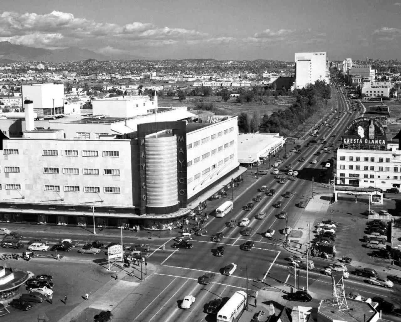
| (1930)^ - Aerial view looking west down Wilshire Boulevard from above Sycamore. The widest street visible, Wilshire, became known as the Miracle Mile, where most high rises were built through the years. The Salt Lake Oil Field is at upper-right and the La Brea Tar Pits at upper-center. Fairfax runs horizontal at top of photo at the end of the oil field. Farmers Market is out of view in the upper-right. |
Historical Notes Developer A.W. Ross foresaw a grand commercial destiny for western Wilshire Boulevard earlier than almost anyone else. In the early 1920s, Ross began buying up land along Wilshire between La Brea Avenue and Fairfax Avenue, a pursuit some observers referred to as "Ross's Folly." He envisioned a destination shopping district that would lure customers from Beverly Hills as well as Hollywood and downtown Los Angeles, encouraging the construction of architecturally distinctive commercial buildings designed for the automobile age. The development paid off dramatically through the late 1920s and into the 1930s as the stretch became known as the Miracle Mile, attracting major retailers including Desmond's, Silverwoods, and eventually the May Company. Even supermarkets like Ralphs built facilities along the boulevard with the grand architectural ambitions of the district in mind. This 1930 aerial view captures the boulevard at the beginning of its Miracle Mile era, with commercial construction underway and the open oil fields and airstrips of just a decade earlier already giving way to the new district. The Salt Lake Oil Field remains visible to the upper right, but its productive days were largely over. Fairfax Avenue at the top of the frame marks the western boundary of Ross's original development vision. Ross remained an active force in Wilshire Boulevard development well into the 1960s, watching the boulevard draw the city's population ever farther west. Click HERE to see more Early Views of the Miracle Mile (1940s & 1950s). |
* * * * * |
Wilshire Boulevard - Double-Decker Buses |
One of the most distinctive features of Wilshire Boulevard in the 1930s was the double-decker bus. The Los Angeles Motor Coach Company, a joint venture of Pacific Electric and Los Angeles Railway, launched service on Wilshire in 1923 beginning at MacArthur Park and extending westward as the commercial corridor grew. The double-decker buses became a beloved feature of the boulevard, their open upper decks offering riders a commanding view of the Miracle Mile. The photographs in this section show the buses sharing Wilshire with automobiles at the intersection of Fairfax, with the skyline of the emerging commercial district visible in the background. |
 |
|
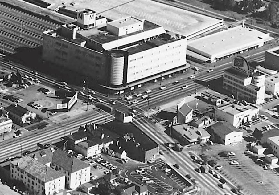
| (1938)^ – Looking NW showing the intersection of Wilshire and Fairfax with Simon’s Drive In Cafe seen on the left (NW corner). The following year construction would begin on the May Company on the lot with the billboard (NE corner). |
Historical Notes Wilshire Boulevard holds a distinction unique among Los Angeles streets: it was the only street in the city permanently banned from having surface rail. When developer Henry Wilshire donated a strip of land for the boulevard in the late nineteenth century, he attached conditions prohibiting rail lines, heavy trucking, and industrial uses, intended to protect the exclusive residential character he envisioned for the corridor. That ban, written into the municipal code, meant that when transit operators wanted to serve the growing commercial district in the 1920s, the only option was the motor bus. Pacific Electric and Los Angeles Railway responded by forming the Los Angeles Motor Bus Company in 1923, later renamed the Los Angeles Motor Coach Company. The company ran the Wilshire Line using double-decker buses that could carry between 54 and 64 passengers depending on the model. Their distinctive livery became a familiar sight on the boulevard, and film production companies frequently rented them for location shoots. By 1949, when the company ceased operations, the double-decker had become a memory, replaced by single-level coaches on a boulevard that looked very different from the one the first buses had traveled. |
 |
|
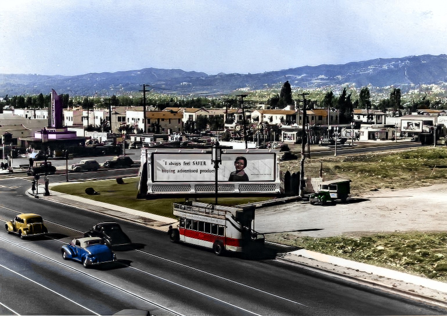
| (1938)* - A double-decker bus is parked by the curb near the intersection of Wilshire and Fairfax. Large signboard reads: "I always feel SAFER buying advertised products." Image enhancement and colorization by Richard Holoff. |
| Historical Notes
The colorized version of this 1938 street scene restores the visual energy of Wilshire Boulevard at the peak of its Miracle Mile era. The double-decker bus, painted in the colors of the Los Angeles Motor Coach Company, would have been a prominent presence on the boulevard, its upper deck rising above the rooflines of parked automobiles and offering passengers an elevated view of the storefronts along the corridor. The billboard message visible behind the bus reflects the national brand advertising culture of the 1930s, when Wilshire Boulevard's heavy traffic made it a valuable location for signage aimed at both pedestrians and motorists. The double-decker bus itself carried advertising on its exterior panels, turning the vehicle into a moving billboard. The combination of transit infrastructure and commercial signage visible in this photograph documents the consumer-oriented character that the Miracle Mile had firmly established by the late 1930s. |
 |
|
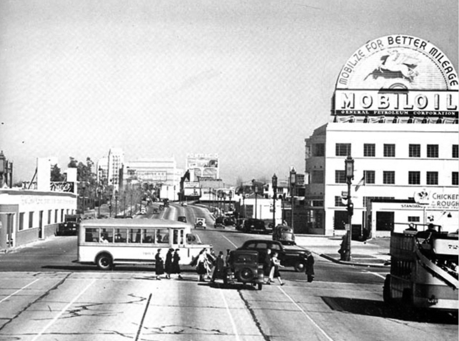
| (1938)* – View looking east on Wilshire Boulevard at Fairfax Avenue. At right is a double-decker bus on the Los Angeles Motor Coach Wilshire Line and crossing Wilshire is a bus on the Fairfax Avenue line. The building on the right with the rooftop Mobil Gas billboard is the 6030 Wilshire building (later the location of the A+D Museum). On the left (NE corner) can be seen what appears to be a single story building but is really a facade in front of the construction site for the new May Company Building (Completed in 1940). To the right of the double-decker bus, on the SW corner and out of view, is a Gilmore gas station. |
| Historical Notes
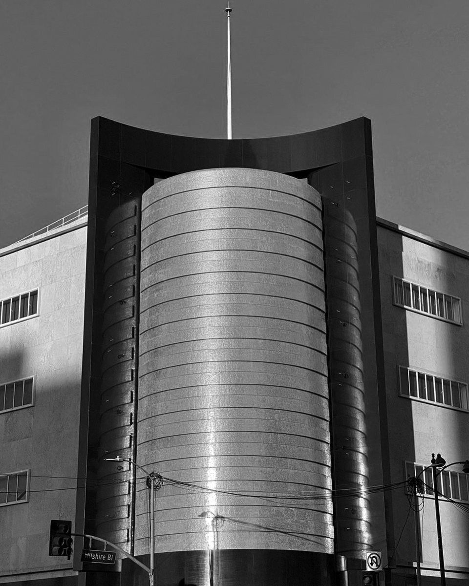
By 1938, Wilshire Boulevard at Fairfax Avenue had assembled nearly all the elements that would define the intersection for the following half century. The double-decker Wilshire Line bus running east along the boulevard carried shoppers and workers between downtown and the growing commercial district. The Fairfax Avenue crosstown bus connected neighborhoods to the north and south. The 6030 Wilshire building, its rooftop advertising facing traffic from both directions, represented the kind of mid-rise commercial construction filling in the boulevard's frontage. And behind the false facade on the northeast corner, the foundations of the May Company Department Store were being laid. The construction activity on the northeast corner would produce one of the Miracle Mile's most iconic buildings. The May Company, designed by the firm of Albert C. Martin and Samuel A. Marx, opened in 1940 with a distinctive cylindrical corner clad in gold mosaic tile and black granite, a design that became one of the most recognized landmarks on Wilshire Boulevard. The building later served as the headquarters of the Academy of Motion Picture Arts and Sciences before being incorporated into the Academy Museum of Motion Pictures, which opened in 2021. The 1938 photograph captures the corner just before that transformation. |
 |
|
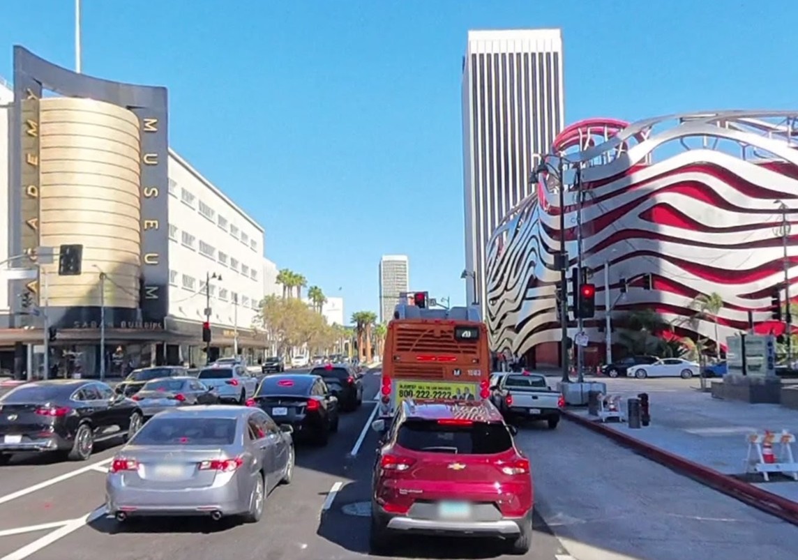
| (2025)* - Looking west on Wilshire Boulevard at Fairfax Avenue in 2025, showing current traffic including a Metro bus on the same corridor served by double-decker buses nearly ninety years earlier. |
| Historical Notes
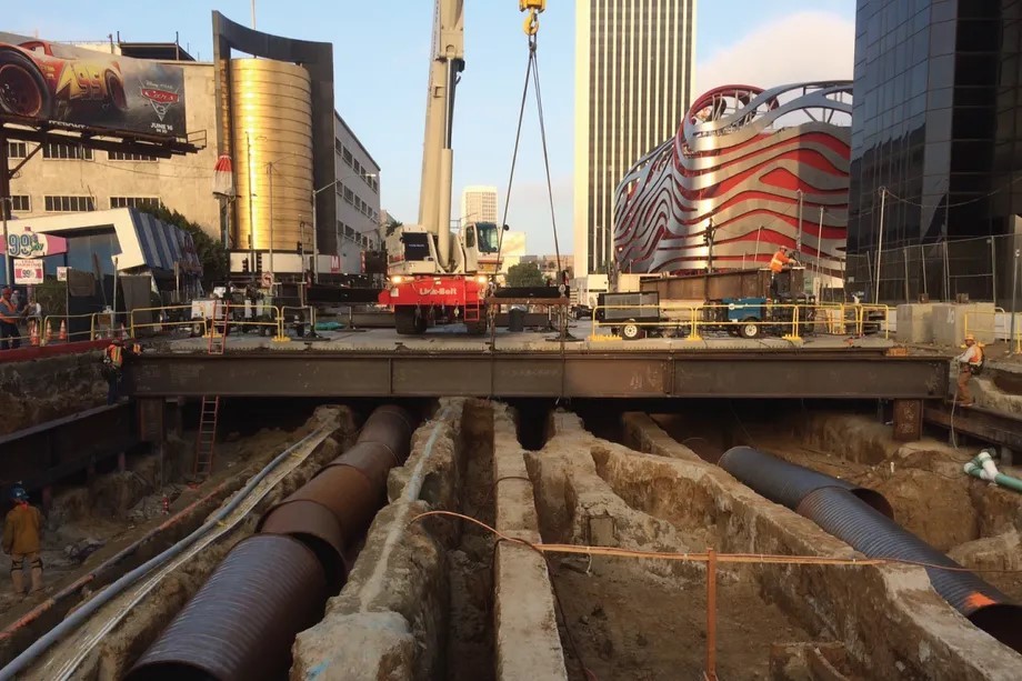
The contemporary view of Wilshire and Fairfax reflects more than eight decades of change since the 1938 photographs were taken. The double-decker buses are gone, replaced by modern Metro service that continues to use the same corridor. The May Company building, now the Academy Museum of Motion Pictures, still anchors the northeast corner with its distinctive cylindrical form, a direct link to the intersection’s earlier development. Beneath the street, a major new chapter is underway. The Metro D Line extension is scheduled to open a Wilshire/Fairfax station in 2026, bringing rail transit to a boulevard that historically banned it. The station lies deep below ground, near LACMA, the La Brea Tar Pits, and surrounding museums. Construction required tunneling through tar sands, methane gas pockets, and areas with abandoned oil wells, conditions rooted in the same geology that once supported the Salt Lake Oil Field. This moment brings the story full circle. The underground forces that first defined this landscape and later delayed subway construction are now simply engineering challenges that have been overcome. For the first time, Wilshire Boulevard will carry rail service, adding a new layer to a corridor shaped for more than a century by oil, automobiles, and constant reinvention. |
Then and Now
 |
|
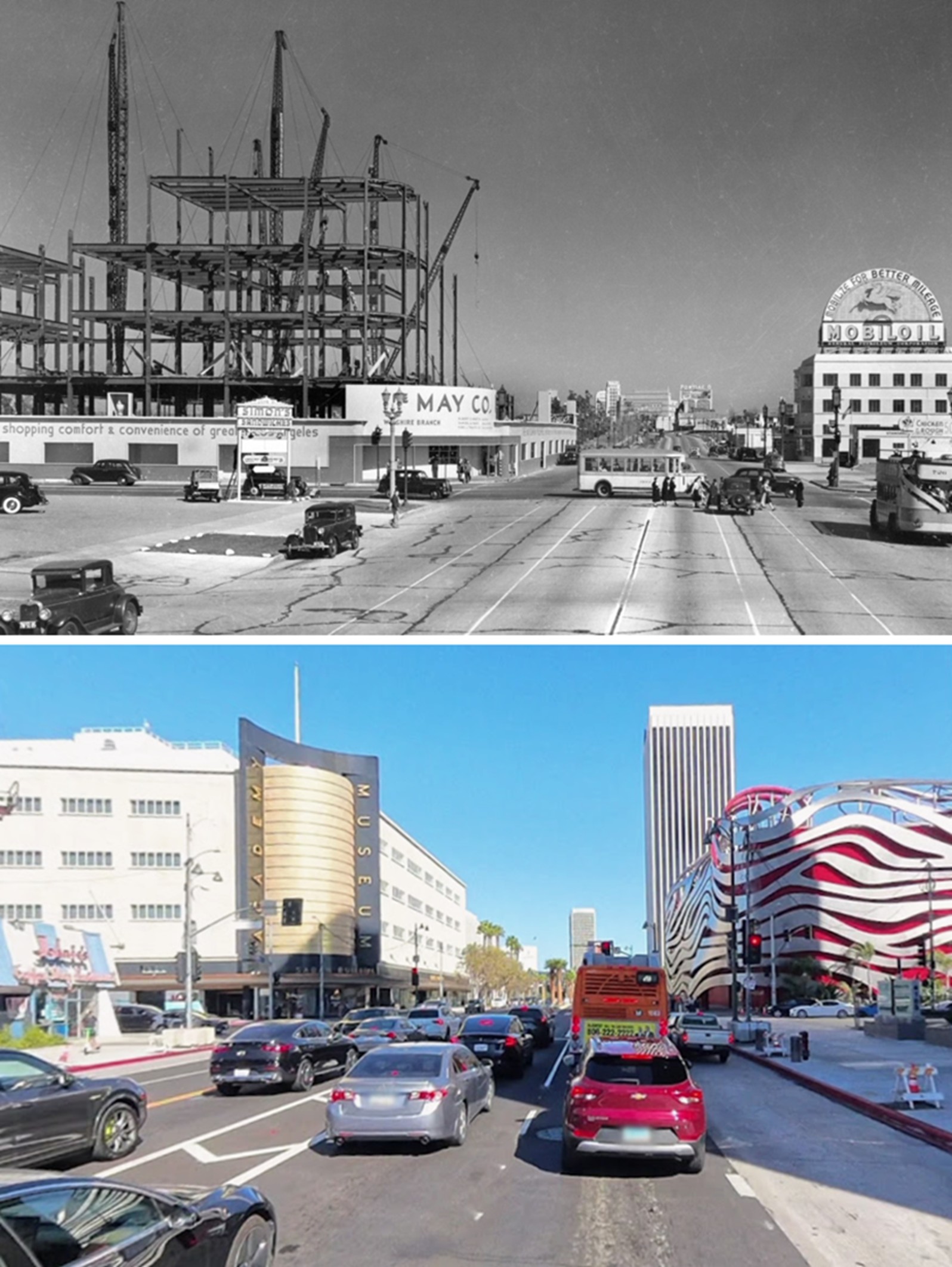
| (1938 vs. 2025)* - Then and now view looking east on Wilshire Boulevard at Fairfax Avenue. The May Company construction site of 1938 is now the Academy Museum of Motion Pictures; the double-decker bus has been replaced by Metro service on the same alignment. Photo comparison by Jack Feldman. |
| Historical Notes
Seen top and bottom, the 1938 and 2025 views of this intersection reveal both how much has changed and how much has persisted. The street grid is the same. The general scale of the boulevard, wide, straight, and oriented toward automobile traffic, is the same. Transit service runs along the same alignment it has occupied since 1923. And the northeast corner, under construction in the upper image, remains one of the most significant addresses on the corridor, now housing the Academy Museum of Motion Pictures. What the comparison makes visible more than anything else is the shift in building scale. The modest two and three story commercial structures of 1938 have been replaced or overshadowed by multi story residential towers and institutional buildings. The skyline of the intersection in 2025 is denser, taller, and more vertically varied than anything that existed in the 1930s. Yet the underlying logic of the corridor, a commercial boulevard serving an automobile oriented city with retail, transit, and institutional uses clustered at key intersections, remains recognizable across the nearly ninety year span of the comparison. |
* * * * * |
Fairfax and Wilshire - Southwest Corner |
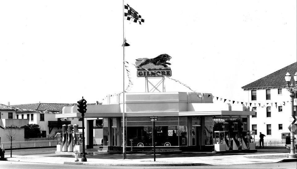
The Gilmore Corner: Gas, Commerce, and a Family Legacy |
 |
|
| (1930s)* – Looking at the SW corner of Wilshire and Fairfax showing a Gilmore gas station. The building on the right (The Carthay Apartments) is still standing. A 16-story high rise stands at this corner today. |
Historical Notes The Gilmore family's presence at the corner of Wilshire and Fairfax was a natural extension of their long history in the district. Arthur Fremont Gilmore had struck oil on his Fairfax farm around 1903, and his son Earl Bell Gilmore built that discovery into a regional petroleum and commercial empire. At its peak, the Gilmore Oil Company operated more than 1,100 branded gas stations throughout the West, with another 2,400 selling Gilmore products alongside other brands. The Wilshire and Fairfax station was strategically placed at one of the busiest intersections on the emerging boulevard, positioned to capture motorists traveling in all four directions. Earl Gilmore's marketing innovations set his stations apart from competitors. He was among the first oil company executives to sell gasoline by its color, using clear glass globes on pump tops to display the distinctive hues of Blu-Green and Red Lion gasolines. The Red Lion brand, accompanied by the slogan "Roar with Gilmore," became one of the most recognized petroleum trademarks on the West Coast. The Gilmore family also developed the original Farmers Market at Third and Fairfax in 1934, built Gilmore Field for the Hollywood Stars minor league baseball team, and sponsored a midget auto racing track, all on land that had once been their dairy farm. By 1940, the Gilmore Oil Company had been absorbed by Mobil Oil, and the branded stations were gradually rebranded in the years that followed. Click HERE to see more Early LA Gas Stations. |
* * * * * |
May Company Department Store |
The Western Anchor: May Company Arrives on the Miracle Mile |
.jpg) |
|
| (1939)* – View looking east on Wilshire at Fairfax showing the May Company Department Store under construction on the NE corner. A double-decker bus is visible at right. Across the street on the NW corner, a sign for Simon's Drive-in can be seen. |
| Historical Notes
Ground was broken on the May Company Department Store in 1939, and the building was completed in 1940. Designed by Albert C. Martin and Samuel A. Marx, the structure featured a bold cylindrical corner element clad in gold mosaic tile and black granite that became one of the most photographed architectural details on Wilshire Boulevard. The building's modernist exterior, set back from the street to accommodate a surface parking lot, was designed for the automobile-oriented shopping model that A.W. Ross had established as the defining pattern of the Miracle Mile. The May Company was one of the major retailers whose arrival on the Miracle Mile validated Ross's original vision for the district. Department stores of this scale required confidence in the long-term commercial viability of a location, and the decision to build at Wilshire and Fairfax confirmed the intersection's status as the western anchor of the corridor. The double-decker bus visible at right in this photograph continued to carry shoppers along the boulevard as construction proceeded. Across the street, Simon's Drive-In on the northwest corner was already one of the most popular destinations on Wilshire, its circular form and illuminated pylon visible from a considerable distance in both directions. The building later served as headquarters for the Academy of Motion Picture Arts and Sciences before being incorporated into the Academy Museum of Motion Pictures, which opened in 2021. |
 |
|
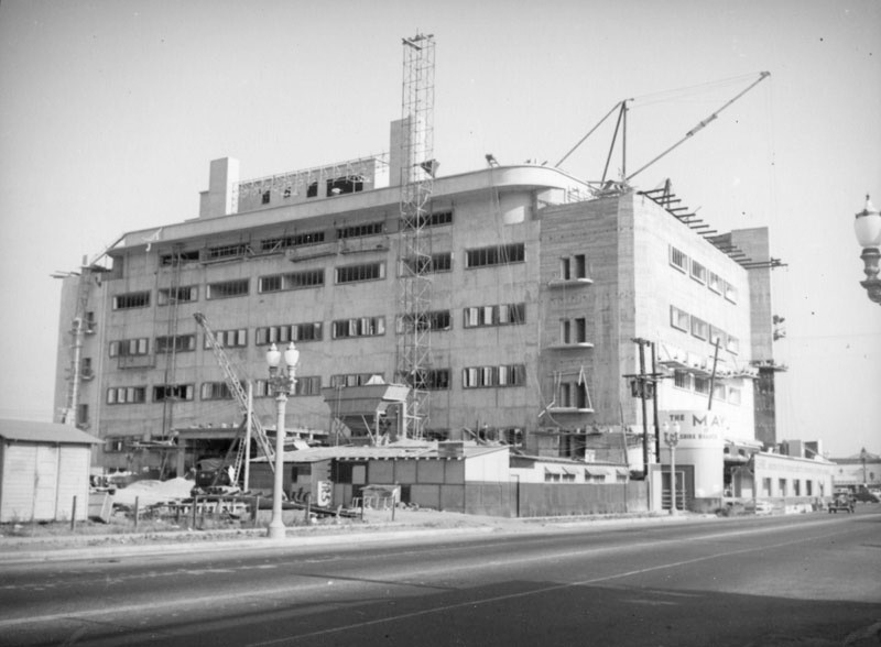
| (1939)* - Looking across Fairfax Avenue toward the northeast corner of Fairfax and Wilshire showing cranes and scaffolding surrounding the Wilshire May Company store still under construction. |
Historical Notes Albert C. Martin and Samuel A. Marx designed the 1939 Streamline Moderne style May Company department store, located at 6067 Wilshire Boulevard. Martin also designed the Million Dollar Theatre and Los Angeles City Hall. |
Then and Now
 |
|
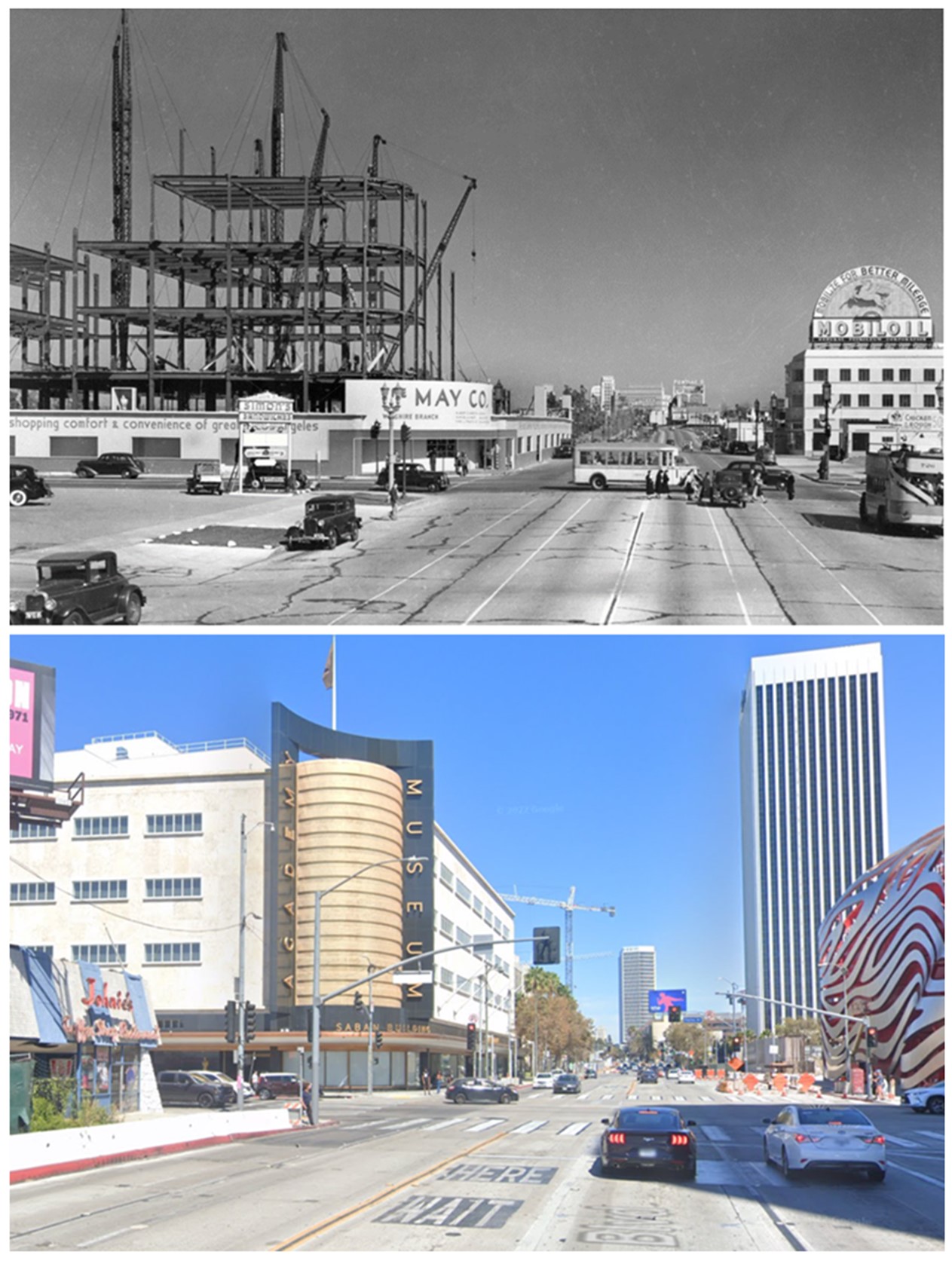
| (1939 vs 2022)* – Looking east on Wilshire Blvd at Fairfax Ave showing the May Co. Dept. Store under construction, today the Academy Museum of Motion Pictures. Photo comparison by Jack Feldman. |
.jpg) |
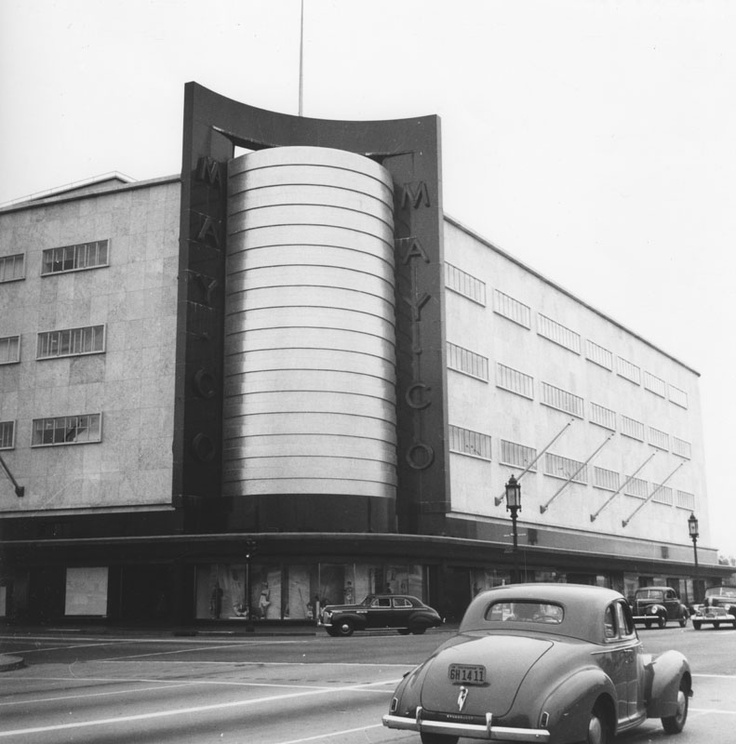
|
| (1940)*– Aerial view showing the May Company Department Store, NE corner of Wishire and Fairfax, shortly after its opening. Across Fairfax (NW corner) can be seen the popular Simon's Drive-in restaurant where the Googie-influenced Johnie's Coffee Shop now stands. |
 |
|
| (ca. 1940)* - May Co. Department Store, located on the northeast corner of Wilshire and Fairfax. A man appears to be standing on top of the May Co. sign. A sign for Simon's Sandwiches can be seen at lower-left (NW corner). |
Historical Notes When it opened, the gleaming May Company building was instantly heralded as the western gateway to the Miracle Mile, beckoning to motorists with an enormous gold-tiled cylinder at the corner of Fairfax Avenue. |
 |
|
| (1940s)**^ - Looking toward the northeast corner of Wilshire and Fairfax where the beautiful May Company Department Store Building stands. |
Historical Notes May Company California was established in 1923 when May acquired A. Hamburger & Sons Co.(founded in 1881 by Asher Hamburger). The company operated exclusively in Southern California until 1989 when May Department Stores had dissolved Goldwater's, based in Scottsdale, Arizona and transferred its Las Vegas, Nevada store to May Company California. |
 |
|
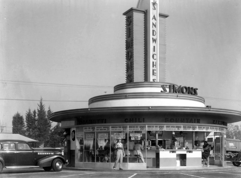
| (1939)* - Simon's Drive-in Restaurant on the northwest corner of Fairfax Avenue and Wilshire Boulevard. This is an engineering notebook photoprint taken from top deck of Wilshire Boulevard Bus. |
Historical Notes Simon's Drive-in Restaurant was built in 1935 and looks very similar to many of the other drive-ins built in the 1930s. That's because so many of these futuristic looking drive-ins were designed by architect Wayne McAllister. Wayne McAllister was a Los Angeles-based architect who was a leader in the Googie style of architecture that embraced the automobile and the Space Age. Inspired by tail fins and gleaming chrome, he elevated the drive-in restaurant to futuristic works of art. He created iconic circular drive-in restaurants in Southern California, including Simon's, Herbert's, Robert's, and McDonnell's in the 1930s. |
 |
|
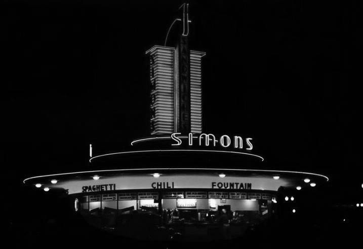
| (1939)^ - A daytime view of Simon's Drive-in Restaurant located on the northwest corner of Fairfax and Wilshire. Through the glass floor-to-ceiling windows, patrons can be seen sitting at the circular counter having their meals. "Spaghetti", "Chili", "Fountain", "Hamburgers" and "Barbecue" can be seen above the windows. A carhop is standing at front, holding food in her hand. |
Historical Notes At one time Simon's Drive-ins dominated the Southern California drive-in restaurant craze. The Simon brothers had operated a chain of successful dairy lunch counters in downtown Los Angeles, and in 1935 decided to capitalize on the growing car culture of Los Angeles by opening auto friendly locations in the emerging commercial centers of Wilshire Boulevard, Sunset and Ventura Boulevards. Click HERE to see more Early LA Drive-in Restaurants. |
 |
|
| (ca. 1940s)* - Night view showing the neon-lit Simon's Drive-in Restaurant at Fairfax and Wilshire, NW corner. |
Historical Notes This is the same corner where the 1950s Johnie's Coffee Shop now stands. Across the street is the old May Company department store building which is now a part of LACMA/the Hollywood Museum. Going back further to the early 1900s, this is where the Chaplin Airfield was once located (Click HERE to see more in Aviation in Early L.A.). |
 |
|
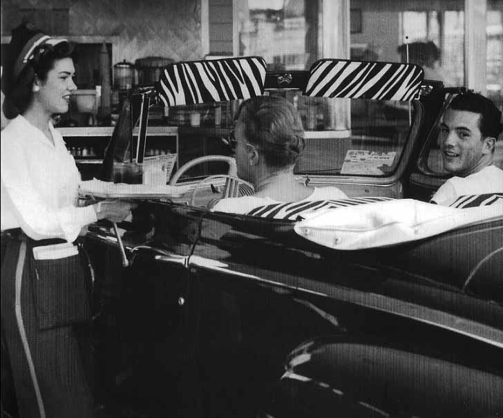
| (1948)* – A couple of jitter-bugs down at Simon's Drive-in wowing the waitress with their zebra-stripe upholstery. Photo courtesy of Curbside Classic |
 |
|
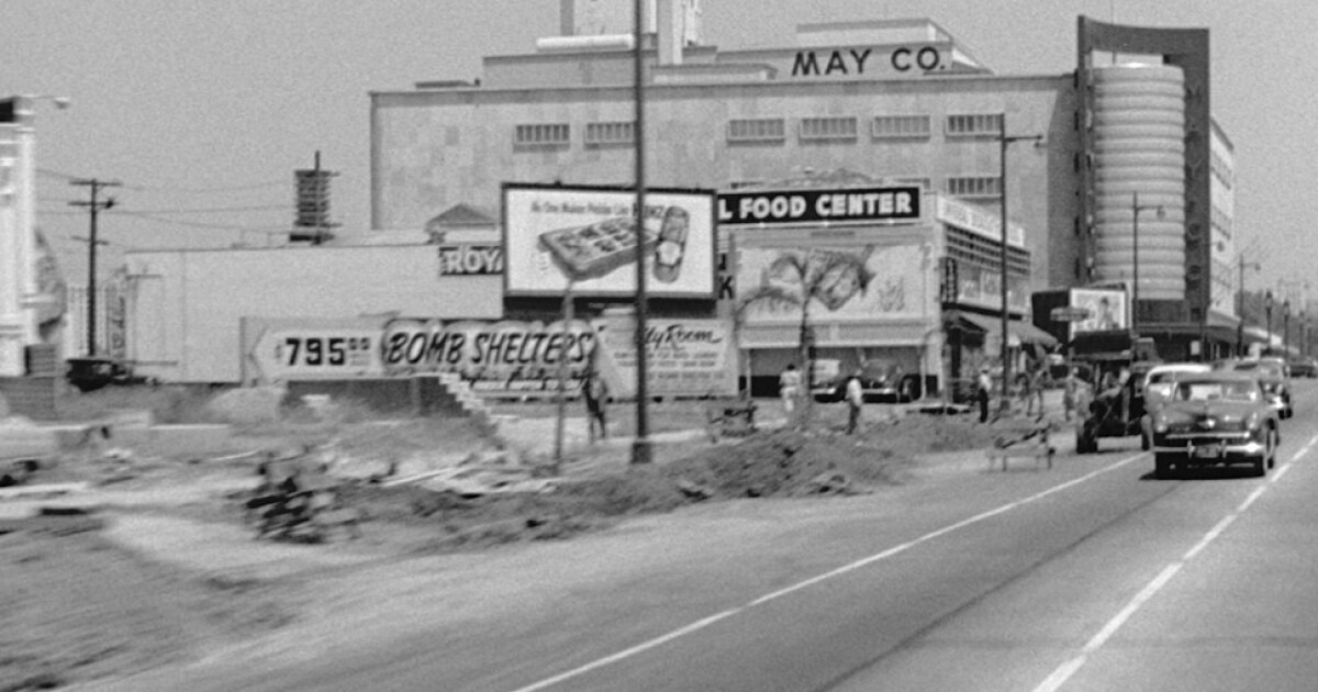
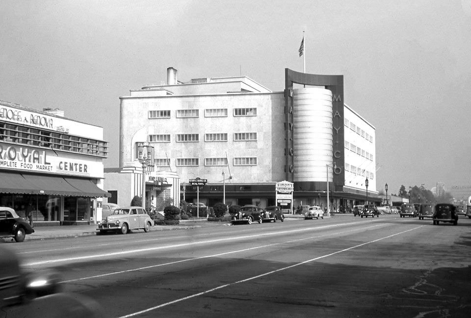
| (ca.1951)* - Looking east on Wilshire Blvd toward Fairfax Ave with the Royal Food Center and May Company in the background. Note the billboard on the left advertising “BOMB SHELTERS” for $795. LA Times Photo |
Historical Notes The bomb shelter craze, also known as the fallout shelter craze, occurred primarily during the 1950s and 1960s. This period was characterized by heightened tensions and fears related to the Cold War between the United States and the Soviet Union. The development and testing of nuclear weapons, as well as the threat of a potential nuclear conflict, led many people to seek ways to protect themselves and their families in the event of a nuclear attack. |
 |
|
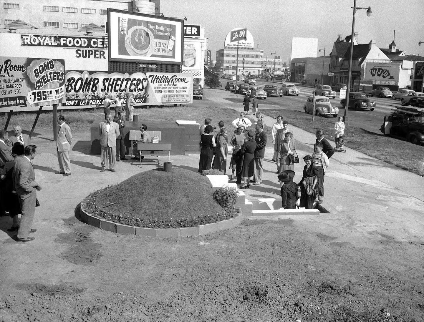
| (1951)* - Salesmen showing off newest design in bomb shelters near the intersection of Wilshire and Fairfax. Photo Don Brinn/AP |
Historical Notes The bomb shelter craze reached its peak in the early 1960s during the Cuban Missile Crisis in 1962, when the United States and the Soviet Union came to the brink of nuclear war. This event heightened the sense of urgency and increased the demand for bomb shelters. The government encouraged citizens to build their own shelters, and there were various public and private initiatives promoting the construction of fallout shelters. |
 |
|
| (1944)* – Looking east on Wilshire Blvd towards Fairfax Ave showing May Company on the NE corner. Across the street (N/W corner) can be seen Simon’s Sandwiches drive-in restaurant. Next to Simon’s is the Art Deco Krandill Mortgage and Investment Company building. |
Historical Notes A. W. Ross saw potential for the area and developed Wilshire as a commercial district to rival downtown Los Angeles. Ross's insight was that the form and scale of his Wilshire strip should attract and serve automobile traffic rather than pedestrian shoppers. He applied this design both to the street itself and to the buildings lining it. |
 |
|
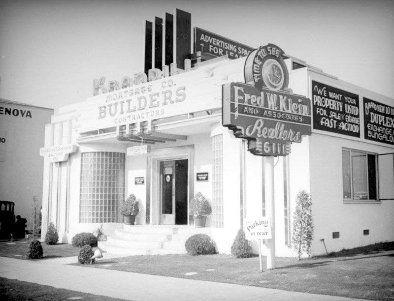
| (ca. 1937)* – Krandill Mortgage and Investment Company featuring builders and contractors is located at 6111 Wilshire Boulevard near Fairfax, just West of Simon’s Drive-in. The Streamline Moderne building features a rounded glass brick entrance and stepped neon sign. A neon clock pole sign announces that it is time to see Fred W. Klein and Associates, Realtors. The rooftop billboard space is for lease, and has interesting Late Moderne features that have been integrated into the building. |
 |
|
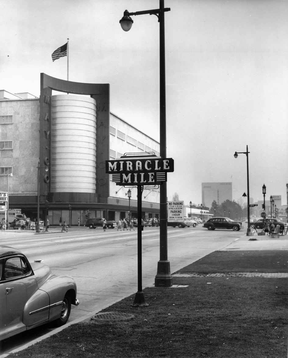
| (1948)*# - View of the Miracle Mile and the May Company Building, looking east down Wilshire Boulevard. Different styles of streetlights run up and down Wilshire Boulevard. Click HERE to see more in Early Los Angeles Street Lights. |
Historical Notes The Miracle Mile development was initially anchored by the May Company Department Store with its landmark 1939 Streamline Moderne building on the west and the E. Clem Wilson Building on the east, then Los Angeles's tallest commercial building. |
 |
|
| (1940s)^ - View looking at the intersection of Fairfax Avenue and Wilshire Boulevard. The May Company Building can be seen on the northeast corner. |
Historical Notes The May Company Building has a Streamline Modern style with gold corner towers. Built in 1940. Architects: A.C. Martin, S.A. Marx. In 1992, the building was designated LA Historic-Cultural Monument No. 566 (Click HERE to see complete listing). |
 |
|
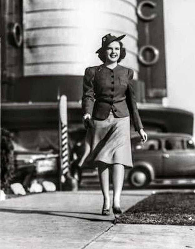
| (1940)* - Judy Garland on Wilshire Blvd just west of Fairfax with May Company department store seen in the background. Photo courtesy of Paul Wright |
 |
|
| (1940s)* – Postcard view looking East on Wilshire toward Fairfax with the May Co. store standing tall on the NE corner. A sign for "Miracle Mile" is seen at right; Mobilgas service station at right (SW corner); Simon’s Drive-in on the left (NW corner); also seen is an over-sized billboard advertising Cresta Blanka wine across from the May Co. |
 |
|
| (1940s)* - Wilshire and Fairfax looking Northeast toward the May Co. Building. Photo courtesy of the Margaret Herrick Library |
Historical Notes May Company California was established in 1923 when May acquired A. Hamburger & Sons Co.(founded in 1881 by Asher Hamburger). The company operated exclusively in Southern California until 1989 when May Department Stores had dissolved Goldwater's, based in Scottsdale, Arizona and transferred its Las Vegas, Nevada store to May Company California. |
 |
|
| (1940s)* – Aerial view of Wilshire Blvd facing east at Fairfax Ave, showing the May Company department store on the NE corner. Simon's Drive-in can be seen at lower-left on the NW corner. This intersection was, and still is, referred to as the western gateway to the Miracle Mile. Source: Bison Archives |
Historical Notes It was not until 1928 that the Miracle Mile acquired its glamorous appellation. Ross originally gave his development a much less-memorable name: Wilshire Boulevard Center. According to a story Ross was describing his vision for the development when a friend interjected: "From the way you talk, A.W., one would think this is really a miracle mile." The name, with its obvious promotional value, stuck. |
 |
|
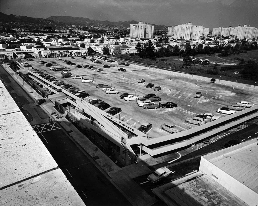
| (1954)* – Aerial bird’s-eye view of the busy intersection of Fairfax Ave and Wilshire Blvd in 1954. The May Co. department store, which opened in 1939 on the northeast corner, dominated the corner then as it does now. We can see their huge parking lot behind and to the east. The popular Simon’s drive-in that stood on the northwest corner during the 30s and 40s is now gone, and not yet replaced by Johnie’s. On the other side of the May Co (top-right of photo), there is a long flat building. This was May Company's home appliance department. |
 |
|
| (ca. 1953)* – View looking northeast from the roof of the May Co. Building showing multi-level store parking below, the Park La Brea Towers, and the Hollywood Hills in the distance. Photo by Julius Shulman via Getty Collection |
 |
|
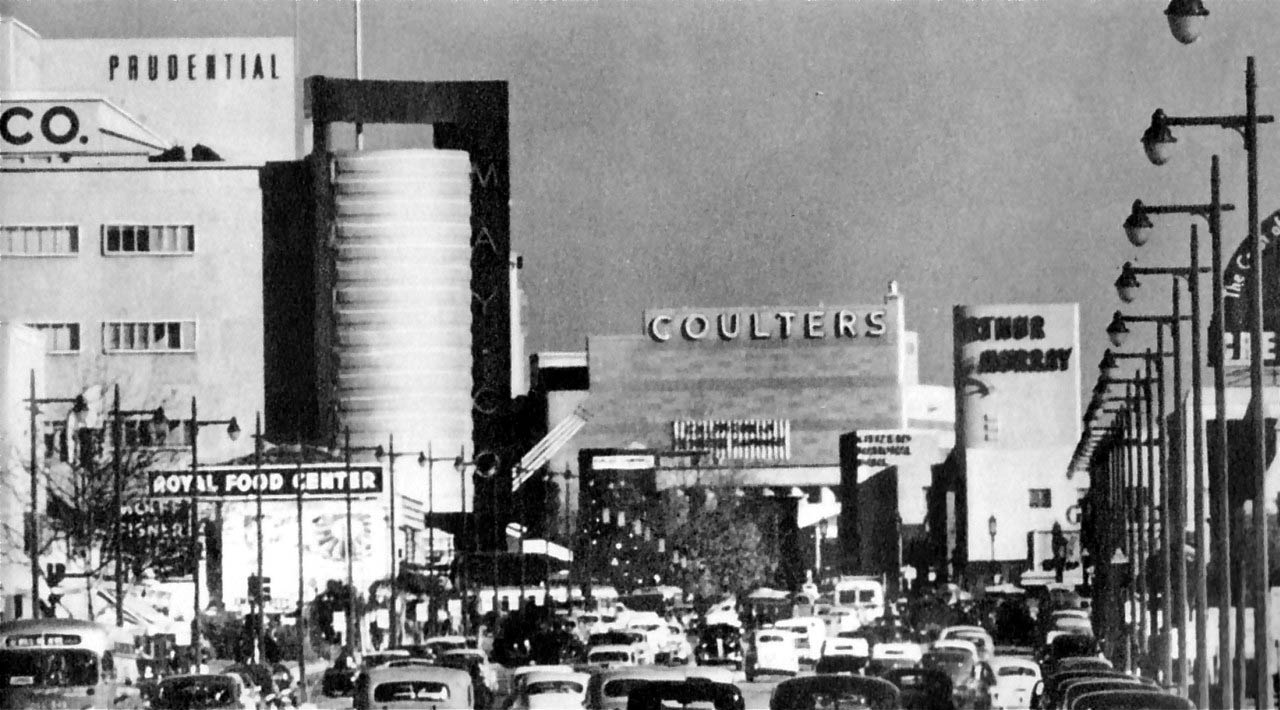
| (1940s)* – Panoramic view using telephoto lense looking east on Wilshire Boulevard through the Fairfax Avenue intersection. We can see the May Company department store (now part of LACMA and future home of the Hollywood museum of the Academy of Motion Picture Arts and Sciences), Prudential Building, Coulter's Department Store, and the Arthur Murray Dance Studio. This “Miracle Mile” stretch of Wilshire Blvd is busy now but back then it looks positively jam-packed! |
Historical Notes Ross gave Wilshire various "firsts," including dedicated left-turn lanes and timed traffic lights, the first in the United States. He also required merchants to provide automobile parking lots, all to aid traffic flow. Major retailers such as Desmond's, Silverwood's, May Co., Coulter's, Mullen & Bluett, Myer Siegel, and Seibu eventually spread down Wilshire Boulevard from Fairfax to La Brea. Ross ordered that all building facades along Wilshire be engineered so as to be best seen through a windshield. This meant larger, bolder, simpler signage and longer buildings in a larger scale. They also had to be oriented toward the boulevard and architectural ornamentation and massing must be perceptible at 30 MPH instead of at walking speed. These building forms were driven by practical requirements but contributed to the stylistic language of Art Deco and Streamline Moderne. |
 |
|
| (1950)* – Looking north on Fairfax Ave at Wilshire Boulevard with Simon’s Drive-in on the NW corner. |
Historical Notes This is the same corner where the 1950s Johnie's Coffee Shop now stands. Across the street is the old May Company department store building which is now a part of LACMA/the Hollywood Museum. Going back further to the early 1900s, this is where the Chaplin Airfield was once located (Click HERE to see more in Aviation in Early L.A.). |
.jpg) |
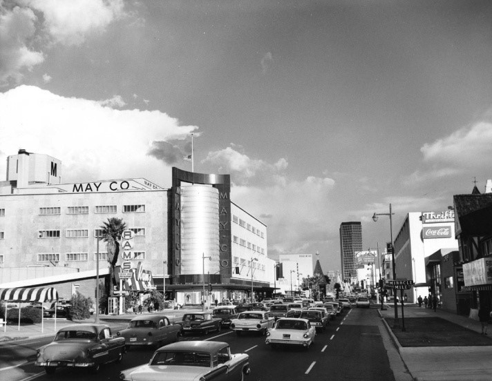
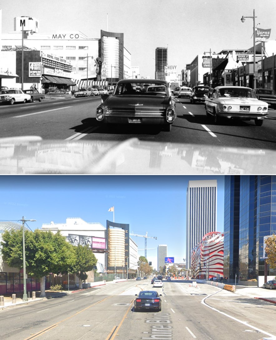
|
| (1964)* – Dashboard view looking east on Wilshire Blvd toward Fairfax showing a Cadillac and Corvair in front of the camera. The 27-story California Federal Bank Building can be seen in the distance and is still under construction. Rams Coffee Shop is now on the NW corner of Wilshire and Fairfax, where Simon’s once stood. |
 |
|
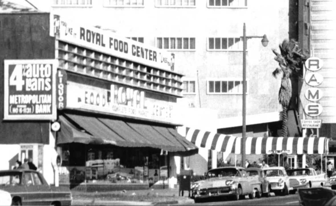
| (1964)* – Blow-up view showing the north side of Wilshire, just west of Fairfax, with Rams Coffee Shop on the corner where Simon’s used to be. On the left is Royal Food Center. |
Historical Notes Romeo’s Times Square opened on the NW corner of Fairfax and Wilshie in 1956. It was in business only a few years, becoming Rams Coffee Shop in the early 1960s, and Johnie’s shortly thereafter. |
 |
|
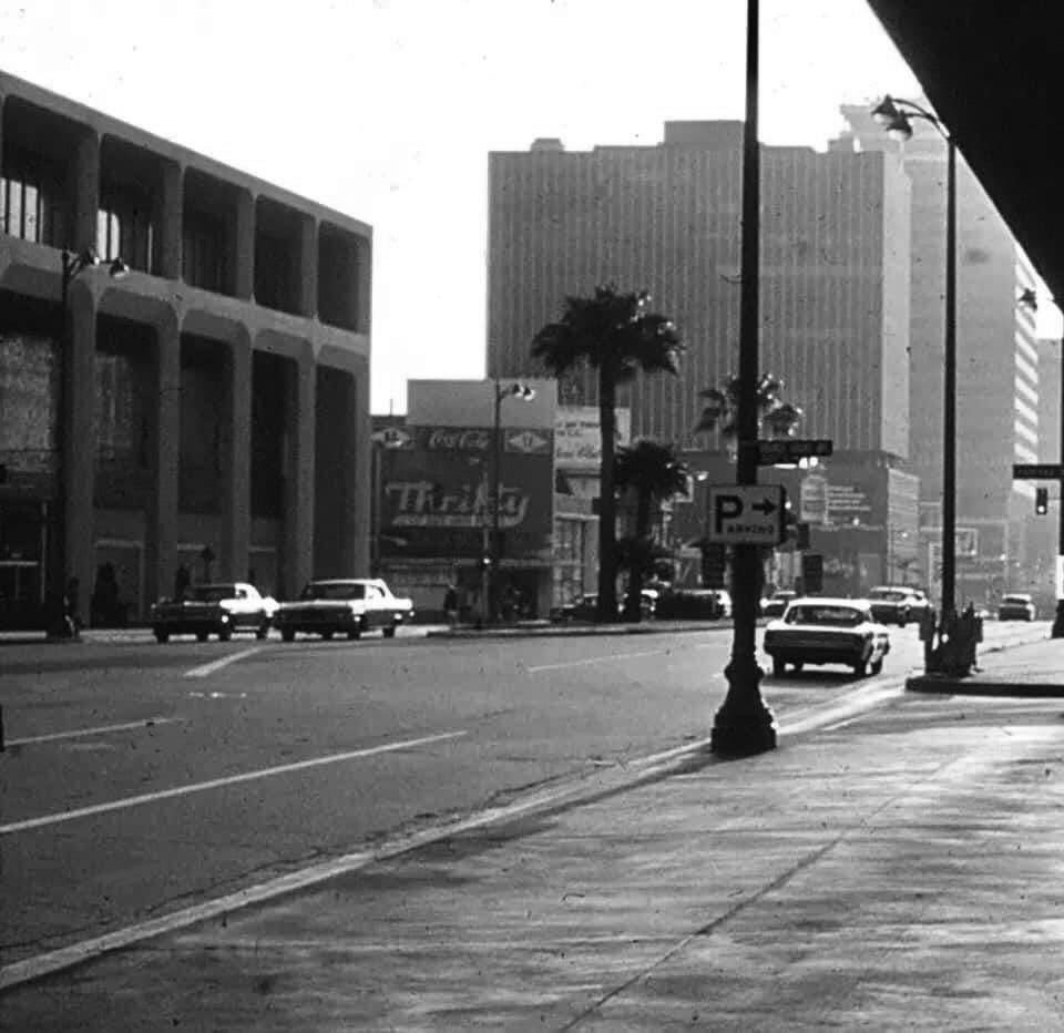
| (ca. 1965)* – View looking east on Wilshire toward Fairfax. Rams Coffee Shop is seen on the NW corner of Wilshire and Fairfax. The 27-story California Federal Bank Building (completed in 1965) can be seen in the distance. A Thrifty store appears to be on the SW corner where at one time a Gilmore Gas Statioin once stood. Photo courtesy of Miracle Mile Residential Association |
Then and Now
 |
|
| (1964 vs 2022)* - Looking east on Wilshire Blvd toward Fairfax Ave. Photo comparison by Jack Feldman. |
 |
|
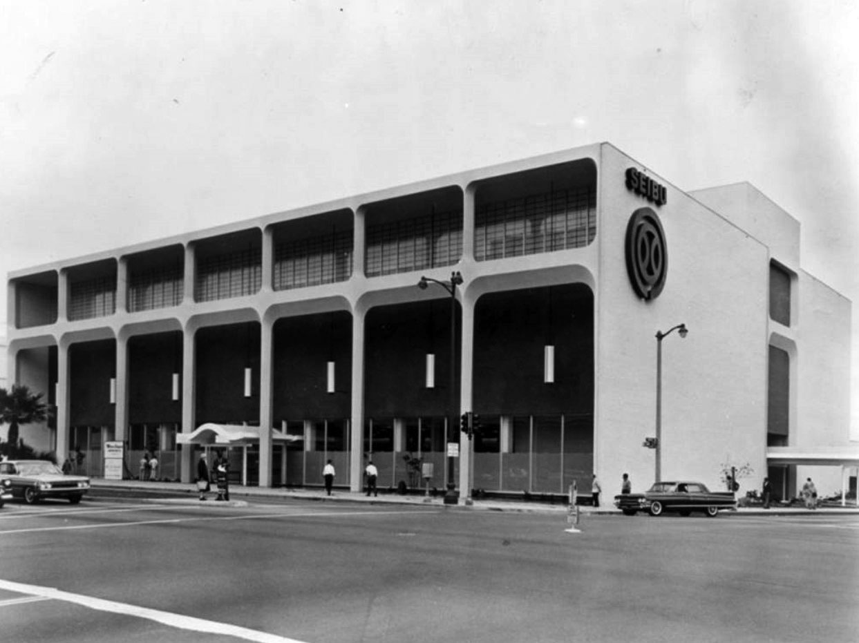
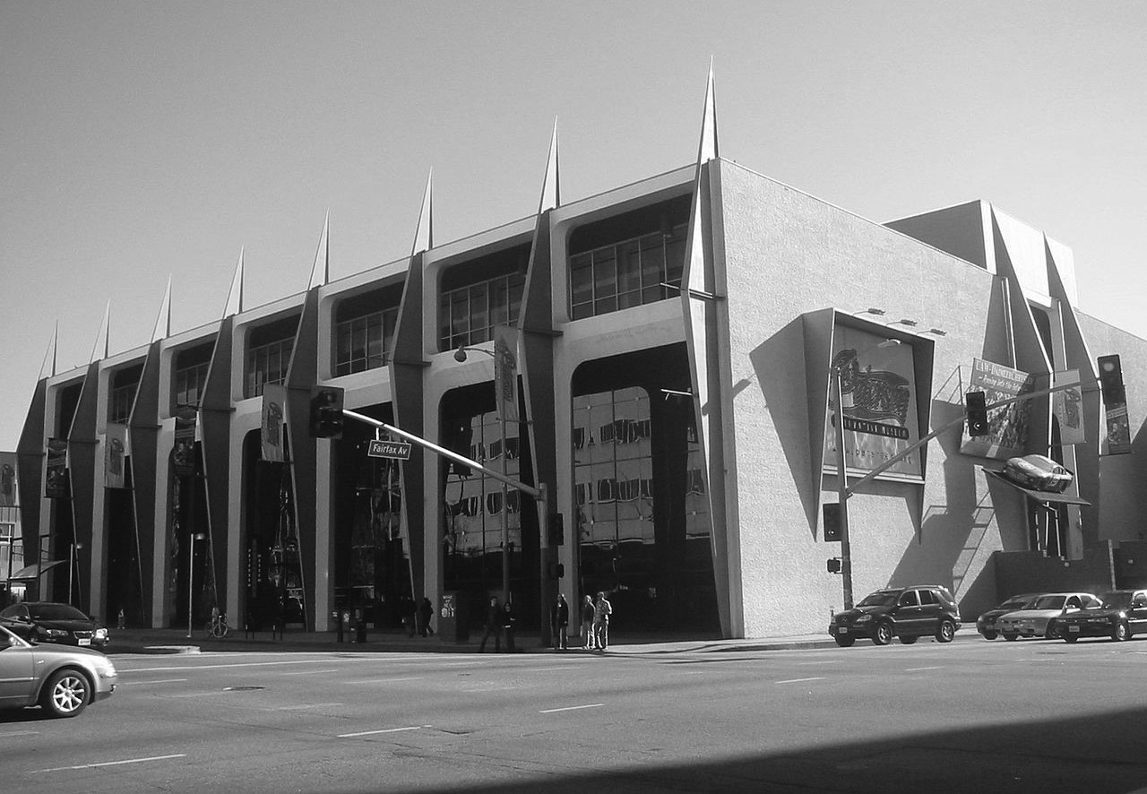
| (1962)* - Photograph caption reads, "New Japanese department store to open in Los Angeles. Seibu store features high-quality Japanese products." Located at 6060 Wilshire Boulevard (SE corner of Wilshire and Fairfax), the historic building was designed by Welton Becket and Associates. |
Historical Notes The Welton Becket and Associates building was originally built in 1962 for the U.S. branch of Japanese department chain store, Seibu. It was the first Japanese department store in the mainland United States. Despite much publicity, the store attracted little more than curiosity and closed after only two years. |
_1962.jpg) |
|
| (1962)* - Finishing touches to the gleaming facade of Los Angeles' newest department store, Seibu, are added as doors open for the first time on March 14, 1962. Across the street is May Co. Wilshire department store. The pair will be friendly competitors. |
Historical Notes This building was originally built in 1962 for the U.S. branch of Japanese department chain store, Seibu but closed after only two years. From 1964-1986, it operated as Ohrbach's department store. Many years later, Robert E. Petersen, founder of Hot Rod and Motor Trend magazines purchased the building, and along with his wife, Margie, founded the $40 million dollar Petersen Automotive Museum on June 11, 1994. The historic building, designed by Welton Becket and Associates, is located at 6060 Wilshire Boulevard. |
 |
|
| (1971)* - View looking west on Wilshire toward Fairfax showing the Orbach’s Department Store in the Seibu Building with a Thrifty across the street on the SW corner. |
 |
|
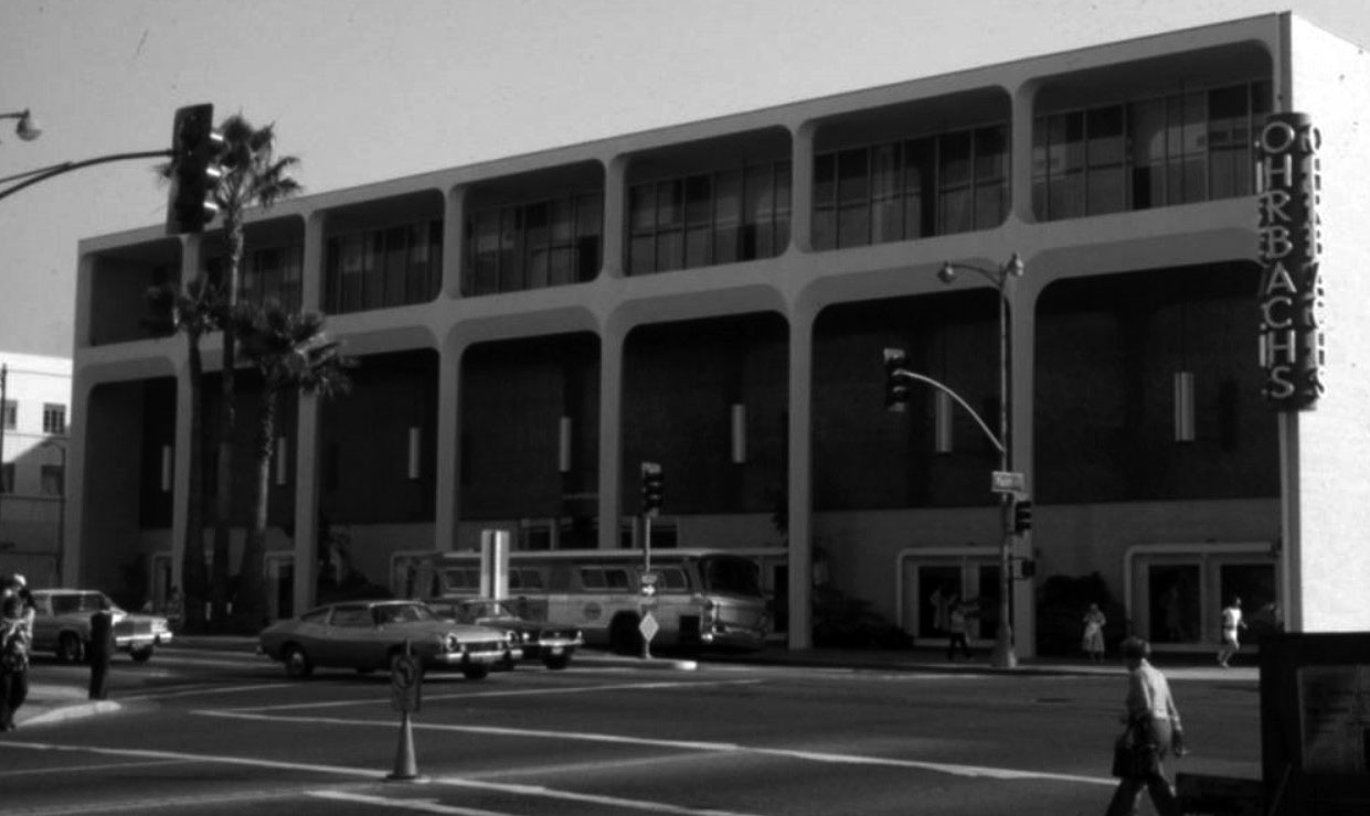
| (1978)* - Exterior view of Ohrbach's Department Store (previously Seibu), located at 6060 Wilshire Boulevard at Fairfax Avenue in Los Angeles. |
Historical Notes Ohrbach's was a moderate-priced department store with a merchandising focus primarily on clothing and accessories. From its modest start in 1923 until the chain's demise in 1987, Ohrbach's expanded dramatically after World War II, and opened numerous branch locations in the New York and Los Angeles metropolitan areas. Its original flagship store was located on Union Square in New York City, and they maintained home and administrative offices in Newark as well as in Los Angeles. The growth of the fashion industry in California encouraged the company's expansion to the state. The firm employed the services of a buying office in Los Angeles as early as 1939 and by 1945 opened its own. In 1948, it leased three floors and the mezzanine in a wing of the Welton Becket– William Wurdeman designed Prudential Insurance Company building on Wilshire Boulevard’s Miracle Mile. In 1965, the Miracle Mile store was relocated in the former Seibu Department Store at Wilshire and Fairfax Avenue. This is the current location of the Petersen Automotive Museum. |
 |
|
| (1970)* - View looking towards May Company from a northbound car on Fairfax Avenue at Wilshire Boulevard. On the right side is Ohrbachs Department Store, which opened in 1964 and closed in 1986. Photo Courtesy of Alison Martino, Vintage Los Angeles. |
Historical Notes Originally introduced by Ford in August 1968 as a package for the 1969 model year, the Mustang Mach 1 title adorned performance oriented Mustang offerings until the original retirement of the moniker in 1978, returning briefly in 2003 and 2004.^ Albert C Martin and SA Marx's 1939-40 May Company Wilshire was still bustling here, and by this time it even had its own gasoline station. Like most of the prominent stores on the Miracle Mile and the Wilshire District, the store's main entrance was in the rear, the easier to accomodate shoppers who parked their cars in the vast lots. In 1993 May Department Stores absorbed the venerable JW Robinson's chain, and so this store was shuttered in favor of the Beverly Hills Robinson's. Fortunately, it wasn't long afterward that the Los Angeles County Museum of Art annexed the building and took great care to preserve it. It is Los Angeles Historical-Cultural Monument No.566. In October 2011 the Academy of Motion Picture Arts and Sciences, in a joint project with LACMA, announced that the building would be the site for a new motion-picture museum. |
 |
|
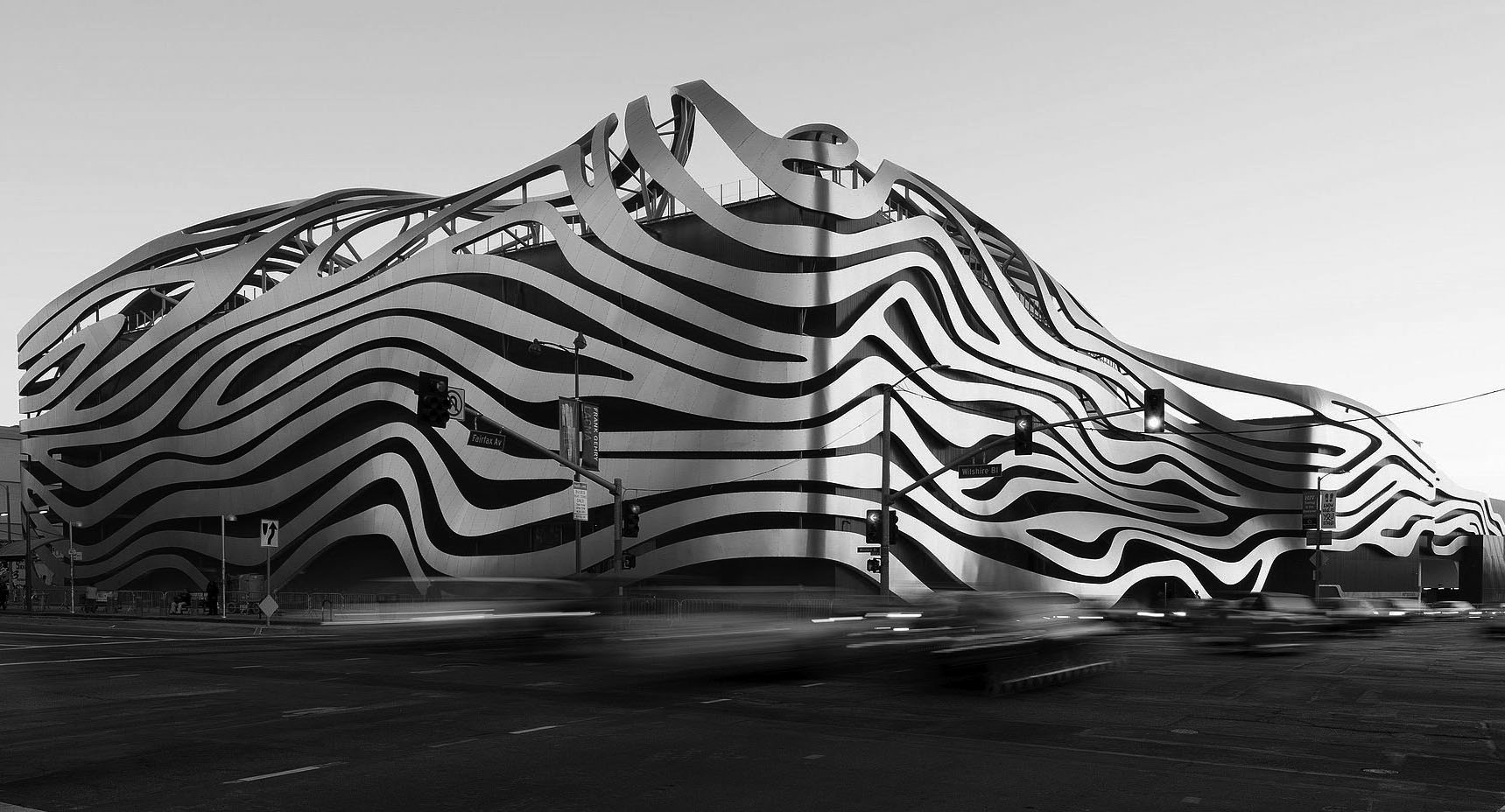
| (2006)* – View showing the Petersen Automotive Museum located in the original 1962-built Seibu Building. Photo by Gary Minnaert via Wikipedia |
Historical Notes Founded on June 11, 1994 by magazine publisher Robert E. Petersen and his wife Margie, the $40-million Petersen Automotive Museum is owned and operated by the Petersen Automotive Museum Foundation. The museum was originally located within the Natural History Museum of Los Angeles County, and later moved to a historic department store designed by Welton Becket. Opened in 1962, the building first served as a short-lived U.S. branch of Seibu Department Stores, before operating as an Ohrbach's department store from 1965 to 1986. Six years after Ohrbach's closed, Robert Petersen selected the largely windowless site as an ideal space for a museum—allowing artifacts to be displayed without harmful exposure to direct sunlight. |
Before and After
|
|
.jpg) |
|
| (1962 vs. 2016) – Seibu Dept Store vs. Peterson Automotive Museum |
 |
|
| (2015)* - View showing the Peterson Automotive Museum located on the SE corner of Fairfax and Wilshire after $125 million renovation. Photo by David Zaitz via Wikipedia |
Historical Notes In 2015, the Peterson Museum underwent an extensive $125 million renovation. The building's façade was redesigned by the architectural firm Kohn Pedersen Fox, and features a stainless-steel ribbon assembly made of 100 tons of 14-gauge type 304 steel in 308 sections, 25 supports and 140,000 custom stainless-steel screws. An Interpretive Master Plan, performed by ObjectIDEA and Brent Johnson Design, re-envisioned the exhibition program and re-organized the collection as three museum experiences under one roof: "The History, Industry, and Artistry of the Automobile." Designers at The Scenic Route configured interior spaces to accommodate changing exhibits. The remodeled museum opened to the public on December 7, 2015. |
 |
|
| (2019)* – View looking SW at Wilshire and Faifax showing the Peterson Automotive Museum and the 16-story 6100 Wilshire Blvd Office Bldg (aka The New Wilshire). Google Street View |
.jpg) |
|
| (ca. 2020)* – Looking down at the 6100 Wilshire Building from the roof of the Peterson Automotive Museum with Johnie’s Coffee Shop seen at lower-right. |
Historical Notes The 16-story 6100 Wilshire Boulevard Building (aka The New Wilshire) was built in 1986 and designed by William L. Pereira & Associates. William L. Pereira personally designed this tower. The wedge-shapped building features a facade of dark blue glass. Two sides of stainless steel balconies frame sliding glass doors in a combination designed to catch the light like cut crystal. |
 |
|
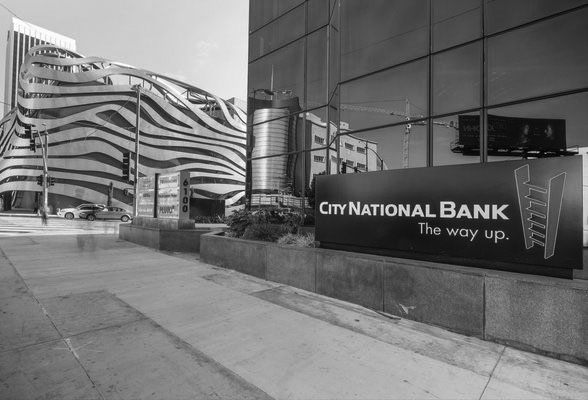
| (2019)* – View looking SW toward Wilshire and Fairfax showing the Peterson Automotive Museum across the street with the 16-story 6100 Wilshire Blvd Office Bldg (aka The New Wilshire) in the foreground at right. A City National Bank sign and also the reflection of the old May Co. Building is seen on the right. |
 |
|
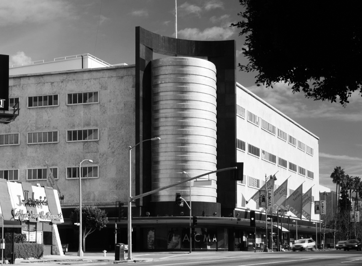
| (ca. 2020)* – View looking East on Wilshire Boulevard toward Fairfax Avenue. All four buildings on the corners of the intersection can be seen: the old May Co. Building, Peterson Automotive Museum, 6100 Wilshire Blvd Building, and Johnie's Coffee Shop. The tall building in the distance is the 32-story SBE Entertainment Group Building, located across the street from the LA County Museum of Art. |
 |
|
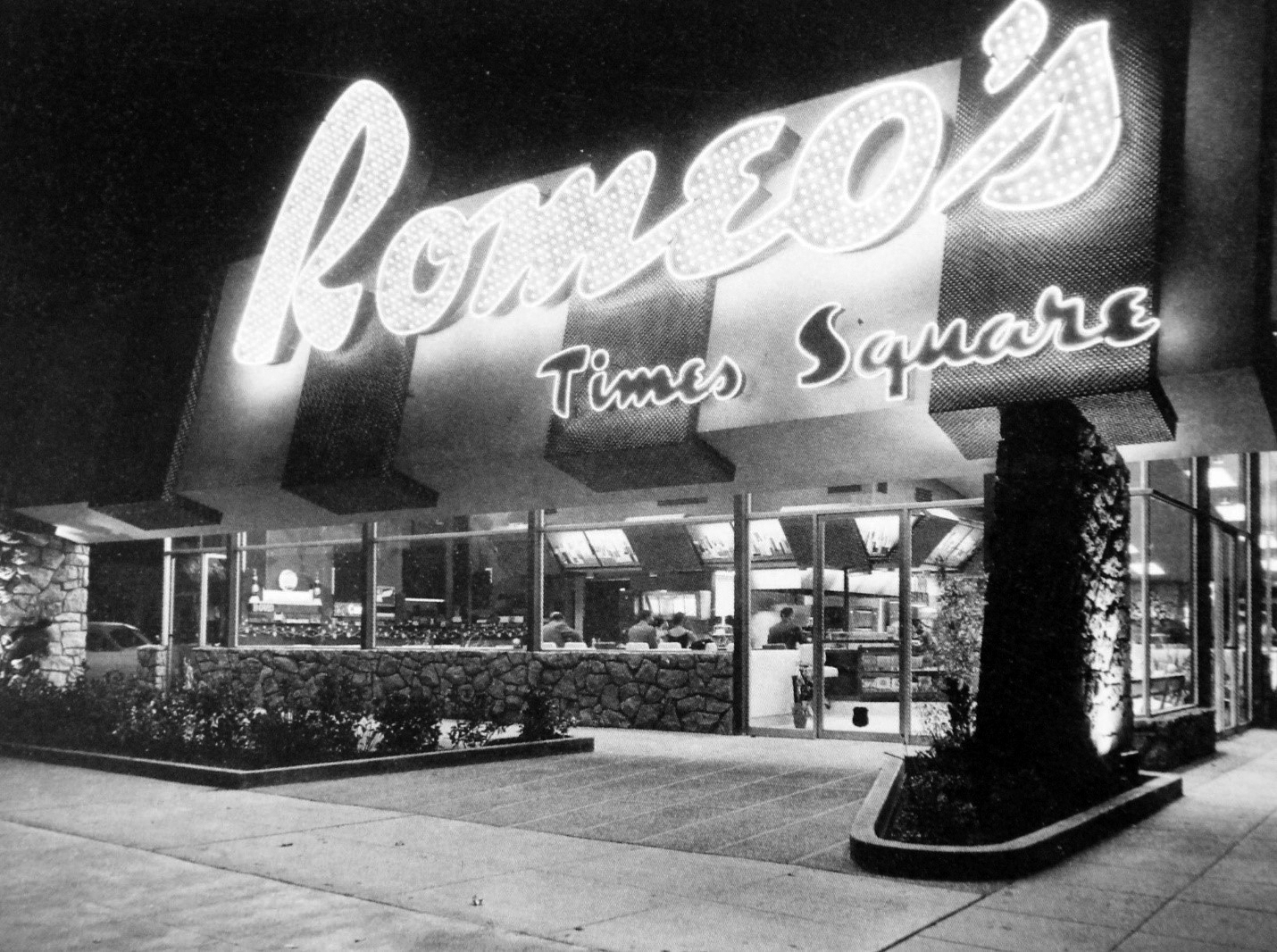
| (ca. 1956)* – View showing Romeo’s Times Square Coffee Shop (later Rams and then Johnie's Coffee Shop) located on the northwest corner of Wilshire Boulevard and Fairfax Avenue. The Googie-style coffee shop was built on the same site where Simon's Drive-in once stood. |
Historical Notes Romeo’s Times Square opened in 1956. It was in business only a few years, becoming Rams Coffee Shop in the early 1960s, and Johnie’s shortly thereafter. |
 |
|
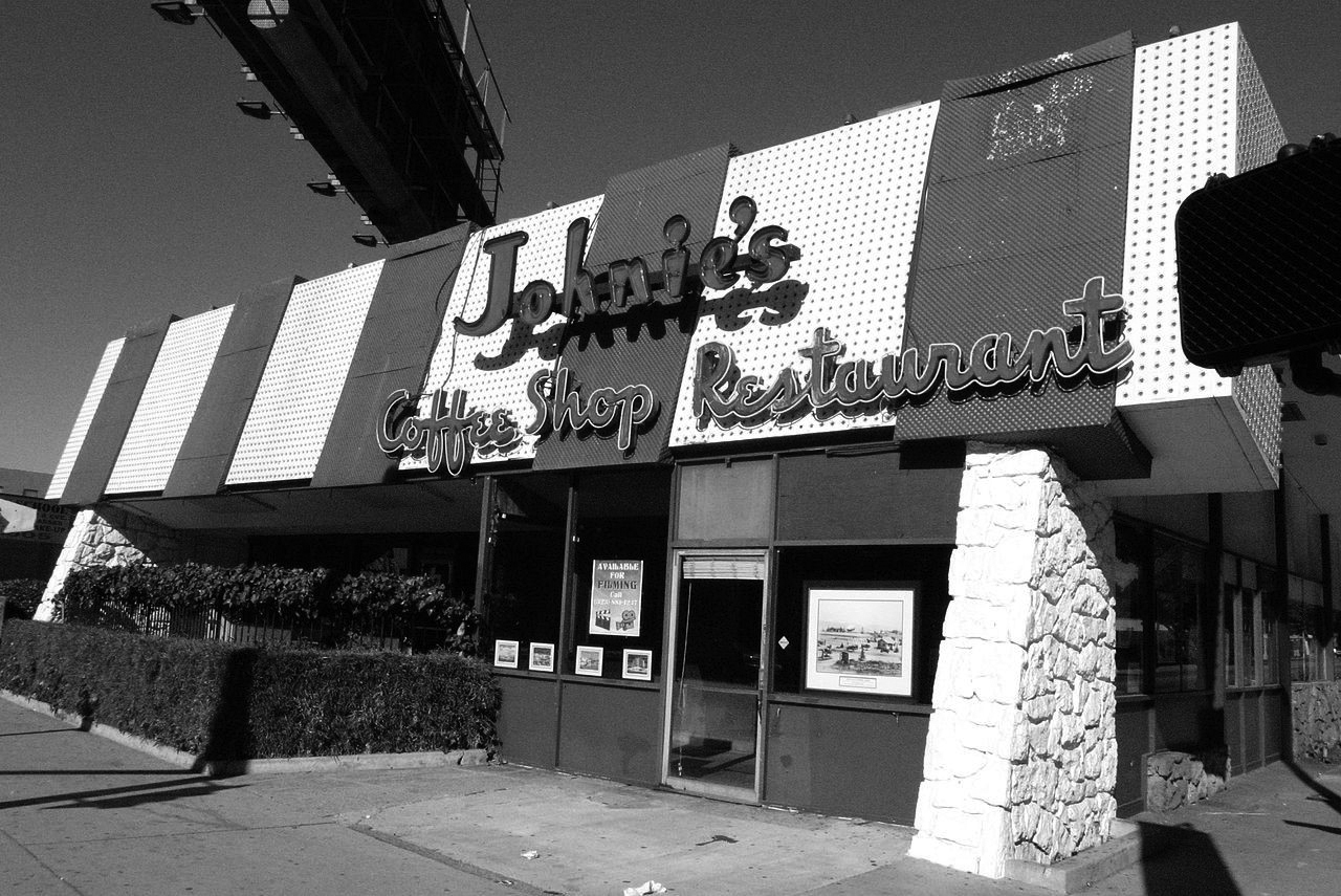
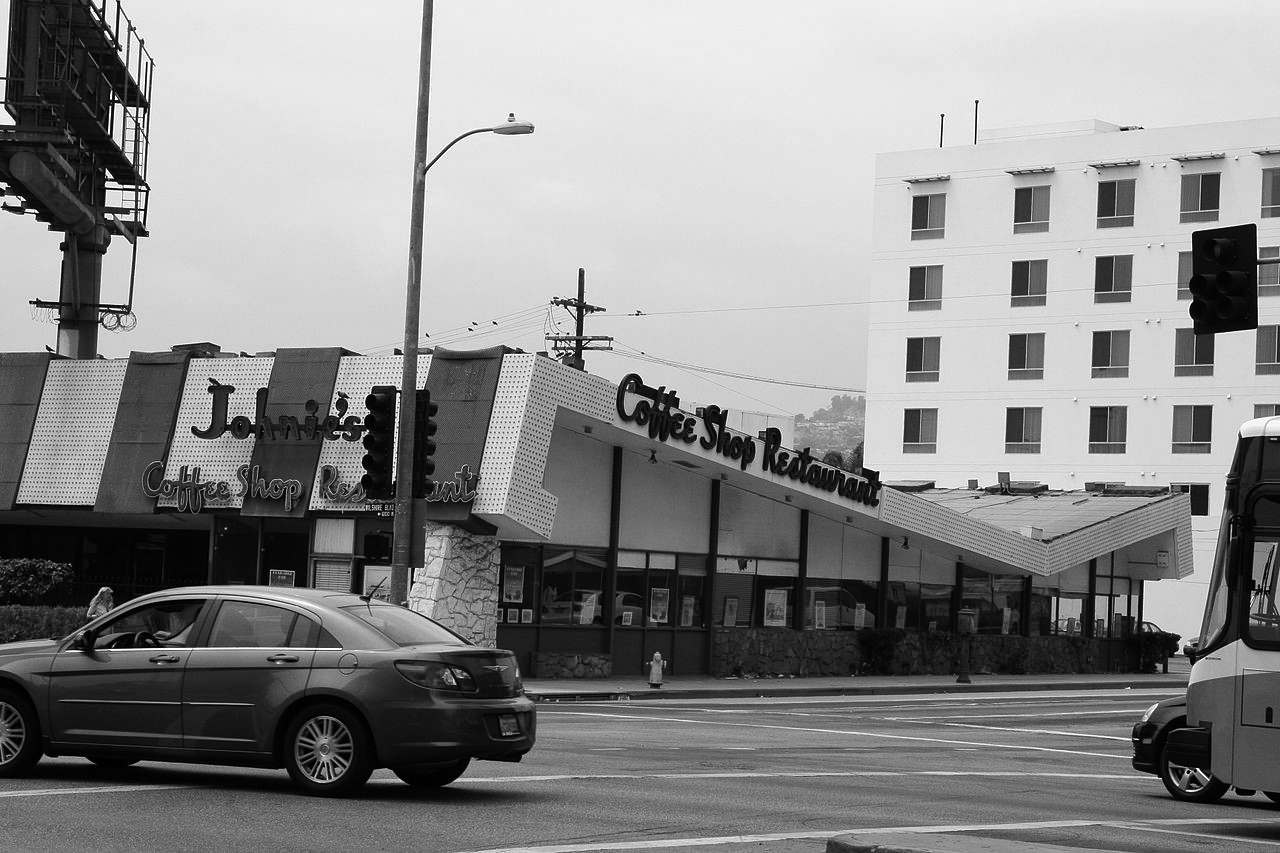
| (2007)* - Johnie's Coffee Shop Restaurant on Miracle Mile in Los Angeles, famous for being used as a location for many movies. Photo by Michael Mooney via Wikipedia |
Historical Notes Architects Louis Armét and Eldon Davis of Armét & Davis designed the building, contributing to their reputation as the premier designers of Space Age or Googie coffee shops—including the landmark Pann's Coffee Shop in Ladera Heights, Norms Restaurant on La Cienega Boulevard, and several Bob's Big Boy restaurants. The restaurant is perhaps best known as the setting for much of the first act of the 1988 cult film Miracle Mile, in which a patron learns that a nuclear war is about to begin. The restaurant also appeared in a 1999 Tom Petty and the Heartbreakers music video, "Swingin';" in a 2003 Reba McEntire music video, "Somebody;" and extensively in Sean Kingston's music video "Beautiful Girls." The restaurant is seen in several movies, including Volcano, starring Tommy Lee Jones; The Big Lebowski, starring Jeff Bridges and John Goodman; Reservoir Dogs starring Harvey Keitel and Tim Roth; and American History X, starring Edward Norton. Johnie's was also featured in the 2000 film Gone in 60 Seconds with Nicolas Cage. |
 |
|
| (2009)* – View looking at Johnie's Coffee Shop with its Googie-style Architecture, located on the NW corner of Wilshire and Fairfax. Photo by ChildofMidnight via Wikipedia |
Historical Notes The restaurant was purchased in 1994 by the Gold family, founders of the 99 Cents Only Stores, and closed in 2000. The family leases the Johnie's parking lot to the Wilshire Boulevard 99 Cents Only outlet two doors away. Today, the largely intact interior acts as a backdrop for films and television shows. Johnie's was declared a historical landmark (No. 1045) by the Los Angeles City Council on November 27, 2013. |
 |
|
| (1980s)* - Johnies Coffee Shop and the May Company Building. - two iconic structures still standing at Fairfax and Wishire. Photo courtesy of Jeanie Lee |
Historical Notes The May Company Building was declared LA Historic-Monument No. 566 on September 30, 1992 |
 |
|
| (ca. 2010)* - May Company/LACMA West with Johnie's Coffee Shop across the street. Photo by Tim Street-Porter courtesy of the Academy Museum of Motion Pictures |
Historical Notes In 2018, the historic May Company Building, a Los Angeles Historic-Cultural Monument, was renamed the Saban Building in honor of a $50M gift from Cheryl and Haim Saban and is undergoing an extensive restoration and renovation to accommodate the Academy Museum of Motion Pictures. The May Company/LACMA West Building/Saban Building is scheduled to be repurposed by 2020, at which time The Academy Museum of Motion Pictures is planning to move in. |
 |
|
| (2020)* - The May Company/LACMA West Building (aka Saban Building) being repurposed to become the Academy Museum of Motion Pictures. Photo courtesy of the Academy Museum of Motion Pictures |
Historical Notes The Academy of Motion Picture Arts and Sciences signed a long-term lease with LACMA and is converting the former original department store building into a museum dedicated to motion pictures. The rear addition (Albert C. Martin, 1946) will be demolished to make way for a 140-foot-diameter spherical addition of glass and steel. The project architects are Renzo Piano and Zoltan Pali. |
 |
|
| (2021)* - Purple Line construction looking East on Wilshire toward Fairfax. Photo courtesy of Metro. |
Historical Notes The Los Angeles Metro D Line Extension Project, formerly known as the Purple Line Extension, is a heavy rail subway expansion extending the D Line from Wilshire/Western in Koreatown to the Westside region. The project, overseen by the Los Angeles County Metropolitan Transportation Authority (Metro), is being constructed in three sections. Section 1, which includes the Wilshire/La Brea, Wilshire/Fairfax, and Wilshire/La Cienega stations, began construction in 2014 and is expected to open in 2025. Section 2 extends the line to Century City, with completion slated for 2026, while Section 3 reaches Westwood and is anticipated to open in 2027. Metro has designated the project as a high priority in its long-range plans, with funding secured through voter-approved sales tax measures, Measure R (2008) and Measure M (2016), supplemented by federal funds covering approximately half the total cost. For the Wilshire/Fairfax Station, a station entrance is planned at the southeast corner of Wilshire Boulevard and Orange Grove Avenue. Metro is also in discussions with the Los Angeles County Museum of Art (LACMA) about funding a second entrance, which would help reduce pedestrian crossings at street level while maintaining bus connections. |
Click HERE to see Earlier Views of the Miracle Mile (1920s & 1930s). |
Click HERE to see more Early Views of the Miracle Mile (1940s & 1950s). |
* * * * * |
Please Support Our Cause Water and Power Associates, Inc. is a non-profit, public service organization dedicated to preserving historical records and photos. Your generosity allows us to continue to disseminate knowledge of the rich and diverse multicultural history of the greater Los Angeles area; to serve as a resource of historical information; and to assist in the preservation of the city's historic records. |
For more Historical Los Angeles Views click one of the following:
For Other Historical Views click one of the following:
See Our Newest Sections:
To see how Water and Electricity shaped the history of Los Angeles click one of the following:
Water:
Power:
* * * * * |
References and Credits
* DWP - LA Public Library Image Archive
^ LA Public Library Image Archive
*^Oviatt Library Digital Archives
^^LA Times: Photo Archive; An Oil Well on La Cienega; Mulholland Bridge; A Mountain of Red Cars; The Vincent Thomas Bridge; Hill Street Tunnels; Harbor-Santa Monica Freeway Interchange; Dodgers Caravan,1958
#*MTA Transportation and Research Library Archives
+#Facebook.com: Garden of Allah Novels
#^^Picturetrail.com: KCET - Angels Flight
#^*Downtown LA Public Art: Fort Moore Pioneer Monument
^**Flickr: Enock 1; Eric Richardson
*^#Los Angeles Conservancy: LA Stock Exchange Building; Park La Brea
^#^Pacific Electric Railway Historical Society - Alan Weeks Collection
*#*Westland.net: Venice History
*#^Forum.Skyscraper.com: Arroyo Seco Library; Westwood-Life Magazine; North Los Angeles Street
^#*Metro.net: Mulholland Drive Bridge
**#The California History Room, California State Library: William Reagh
#**Pinterest - California and DailyBreeze.com
#^#Deadhistoryproject.com: Silent Movie Theater
+**Los Angeles' Bunker Hill - Alta Visa Apartments
+##MartinTurnbull.com: Fairfax and Wilshire
^^+How Stuff Works: Chevrolet Impala
+#+Pinterest - California and DailyBreeze.com; Mid Century Hollywood
++#Facebook.com: Photos of Los Angeles
^^#The George A. Eslinger Street Lighting Photo Gallery
^^*Early Downtown Los Angeles - Cory Stargel, Sarah Stargel
***Los Angeles Historic - Cultural Monuments Listing
*^*California Historical Landmarks Listing (Los Angeles)
*^^Nuestra Señora la Reina de los Ángeles: losangelespast.com
**** Pinterest.com: Los Angeles Dodgers; Los Angeles and Hollywood; MacArthur Park w/Downtown Skyline; Gilmore Self-Service Gas Station
**^*California State Library Image Archive
**^#Vintage Los Angeles: Facebook.com - Gilmore Stadium and Field; Cruising Hollywood Blvd
^^^^Depaul.edu: Night Train 55
**#^Vincent Thomas Bridge - Facts and Figures
*#**Flickr-Los Angeles in Good Light - Ron Reiring
^#^^Flickr.com: Michael Ryerson
*#^#Life.time.com: Stoked-Life Goes Surfing
^#^#Pinterest: Bygone Los Angeles
*#*#Abandoned & Little-Known Airfields – Paul Freeman
^#*#LA Magazine: Beverly Park Ponyland
^^##Pacific Electric Railway Historical Society
^^*#Historic LA Theatres: Downtown Broadway Theatres
^^#*LA Observed.com: Decommissioned Street Cars; Bunker HIll, 1964
*^^*Pinterest.com: Bertrand Lacheze
^^**Pinterest.com: Vintage California
^^++Huntington Digital Library Archive
*##*Pinterest.com: Trucks, Pick-Ups, and Gas Stations
*##^LAist.com: Harbor Freeway, 1969; Century Plaza Hotel
##*^Port of Los Angeles: portoflosangeles.corg
##^*Calisphere: University of California Image Archive
##^^Cinema Treasures: Olympic Drive-In
#**#California State University Northridge History: csun.edu
#++#The Pacific Electric Railway Historical Society (PERyHS)
#*##Daily News: Mulholland Bridge
#^**The Go Go's: N/W Corner of Hollywood and Vine
#^*#Flickr.com: Paul Bajerczak
##^#Facebook.com: Classic Hollywood-Los Angeles-SFV
^***UCLA Library Digital Archive
^^^*KCET: Welcome to L.A. River; Four Level Interchange; Construction of 5 Southern California Freeways; Beverly Park and Ponyland; Before the 'Carmageddon': A Photographic Look at the Construction of 5 SoCal Freeways; Seventh and Broadway; L.A.'s First Freeways
****^Facebook.com: West San Fernando Valley Then And Now
*^^^^Los Angeles Maritime Museum
^^^**tumblr.com: John Ferraro Office Building; DWP Office Building
**^^^Facebook.com - San Pedro's Original Website, San Pedro.com
#*#**Facebook.com: Beverly Park - L.A.'s Kiddieland
**#**LMU Digital Archive
**^ Noirish Los Angeles - forum.skyscraperpage.com; Westwood-Life Magazine; Selling Papers on Olive; California Federal Plaza Building; Downtown Aerial 1958; 1949 Construction of 101 Freeway; 1953 Harbor Freeway Construction; Wilshire Blvd, 1949; Zephyr Room and Brown Derby Postcard View; Aliso Before and After 101 Frwy; Vincent Thomas Bridge; Gilmore Aerial; Hollywood Frwy Traffic Jam; 2012 Downtown Skyline; View from GOB; Bonaventure Hotel Aerial; Hollywood and Vine
^* Wikipedia: Hollywood Sign; Carthay Circle Theatre; Fairfax High School; Park La Brea; San Vicente Boulevard; Etymologies of place names in Los Angeles; Los Angeles Central Library; Broadway Tunnel; Pershing Square; Pacific Electric Railway; Gilmore Field; GilmoreStadium; Union Station; Westwood; 6th Street Viaduct Bridge; Figueroa Street Tunnels; Chavez Ravine; 2nd Street Tunnel; Hollywood Freeway; Los Angeles International Airport; Los Angeles City Hall; Wilshire Boulevard Temple; Egyptian Theatre; The Pig 'N Whistle; Sunland-Tujunga; Van de Kamp Bakery Building; Los Angeles County Art Museum; Los Angeles City Oil Field; Los Angeles Railway; Miracle Mile; Interstate 405; Chevrolet Impala; Playa Vista; Harbor Frwy (Interstate 110); History of Los Angeles Population Growth; Los Angeles City Hall Lindbergh Beacon; May Company California; Four Level Interchange; California Federal Bank; Harbor Freeway; Arroyo Seco Parkway; Brown Derby; 2004 Los Angeles Skyline; LA's Oldest Palm Trees; Vincent Thomas Bridge; World Cruise Center; CSUN; Westwood; Westwood Village; UCLA; History of UCLA; 1950s Americal Automotove Culture; Pershing Square; Century Plaza Hotel; California Incline
< Back