Early Views of Glendale
| Historical Photos of Early Glendale |
 |
|
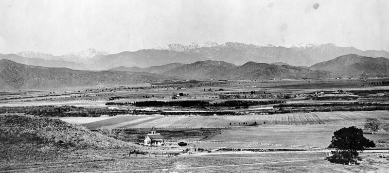
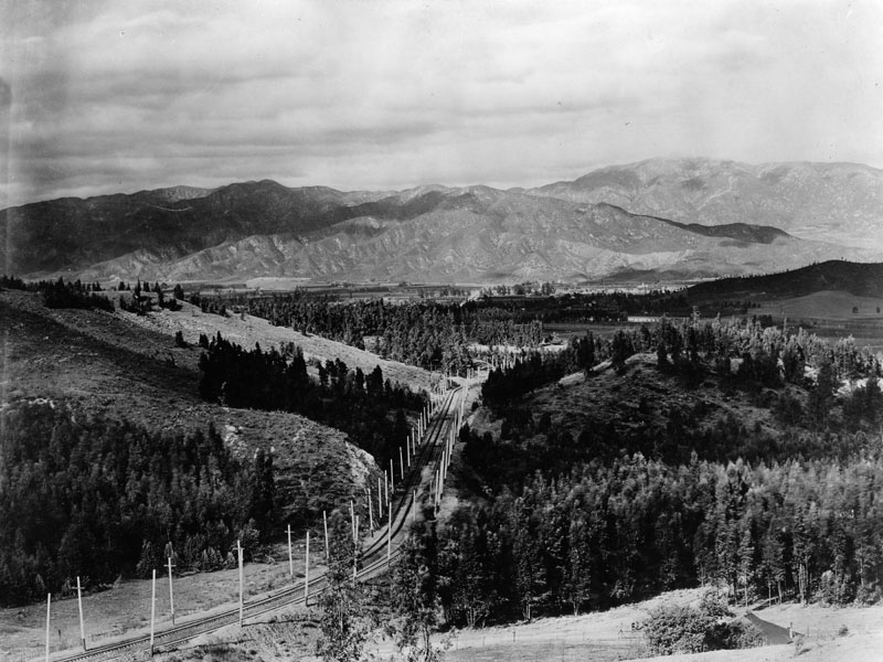
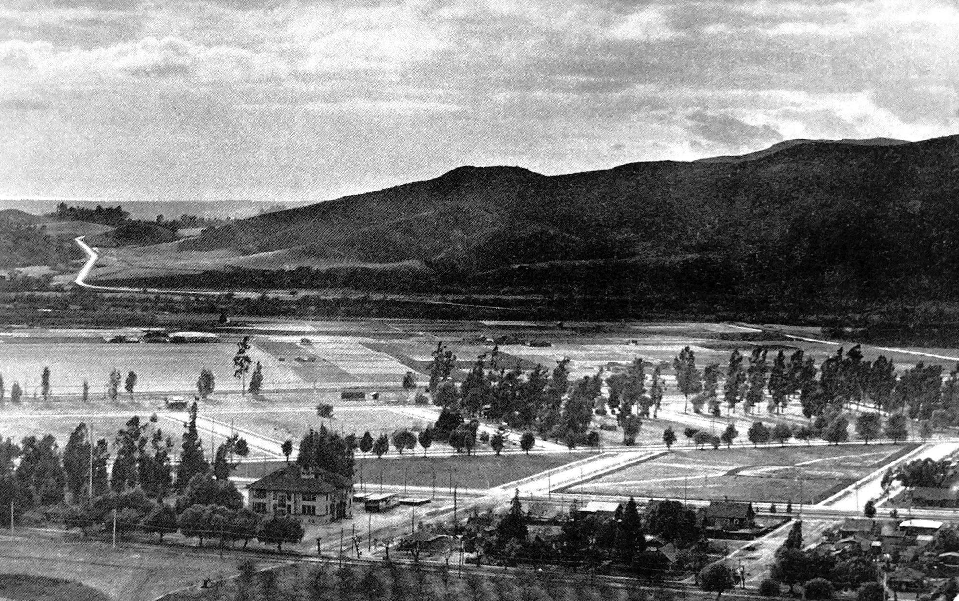
| (ca. 1880s)^ - Panoramic view from Griffith Park of the site of the later city of Glendale as it appeared sometime between the partition of the great San Rafael Rancho in 1870 and the founding of the town in the middle eighties. The Verdugo Hills and San Gabriel Mountains are seen in background. |
Historical Notes The area was long inhabited by the Tongva people (or "People of the Earth"), who were later renamed the Gabrieleños by the Spanish missionaries, after the nearby Mission San Gabriel Arcángel. In 1798, José María Verdugo, a corporal in the Spanish army from Baja California, received the Rancho San Rafael from Governor Diego de Borica, formalizing his possession and use of land on which he had been grazing livestock and farming since 1784. Rancho San Rafael was a Spanish concession, of which 25 were made in California. Unlike the later Mexican land grants, the concessions were similar to grazing permits, with the title remaining with the Spanish crown. |
 |
|
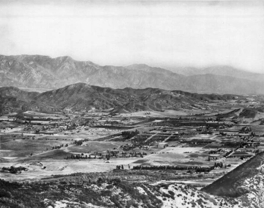
| (ca. 1900)^ - Panoramic view of Glendale looking northeast toward the Verdugo Hills. Only a few houses are seen. |
Historical Notes In 1860, José María Verdugo's grandson, Teodoro Verdugo, built the Verdugo Adobe, which is the oldest building in Glendale. The property is the location of the Oak of Peace, where early Californio leaders including Pio Pico met in 1847 and decided to surrender to Lieutenant Colonel John C. Frémont. Verdugo's descendants sold the ranch in various parcels, some of which are included in present-day Atwater Village, Eagle Rock, and Highland Park neighborhoods of Los Angeles. |
 |
|
| (ca. 1904)^ – Panoramic view of Glendale and Eagle Rock from the hills to the west, looking northeast. Two rows of mountains stripe the background (San Gabriel Mtns. and Verdugo Hills), enclosing the town below in a valley between them and the hills. Residences are spaced far apart. |
Historical Notes In 1884, residents gathered to form a townsite and chose the name "Glendale" (it was bounded by First Street (now Lexington Drive) on the north, Fifth Street (now Harvard Street) on the south, Central Avenue on the west, and the Childs Tract on the east). Residents to the southwest formed "Tropico" in 1887. Residence to the north lived in the Casa Verdugo community. Glendale incorporated in 1906 and annexed Tropico 12 years later, in 1918. In March of 1926, a vote for annexation passed and Casa Verdugo also became a part of the city of Glendale. |
 |
|
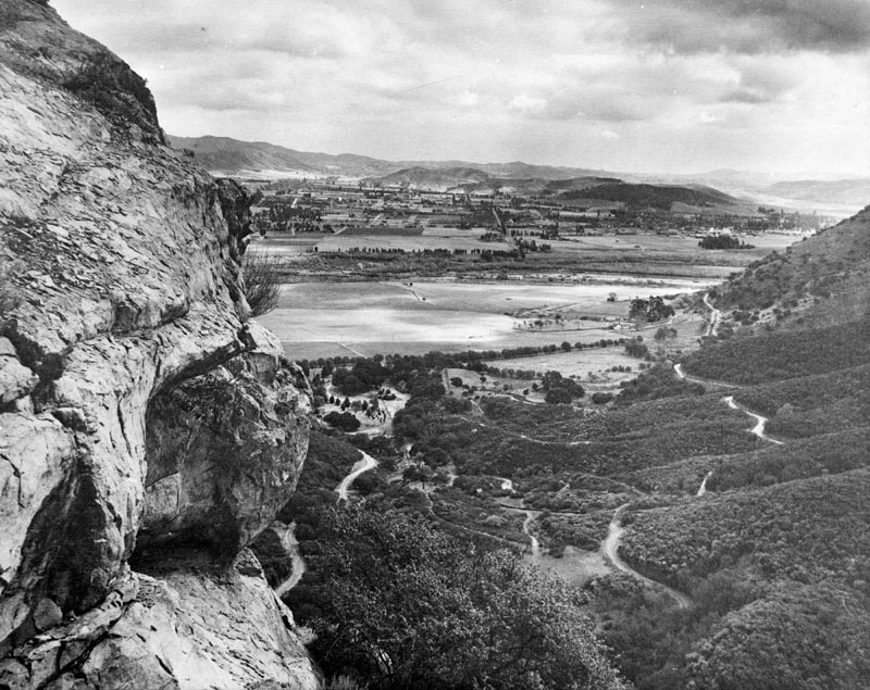
| (1924)* - Panoramic view of South Glendale as seen from Bee Rock in Griffith Park. |
 |
|
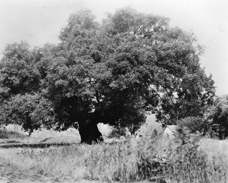
| (ca. 1900)^ - View showing an oak tree (‘The Oak of Peace’) at the Catalina Verdugo adobe in Glendale which was General Andres Pico's camp site before he surrendered to General John C. Fremont. |
Historical Notes Here was drafted the Treaty of Cahuenga on January 12, 1847, signed the following day in Cahuenga Pass. When the home was owned by Dr. and Mrs. Ernest G. Bashor, they named it "El Roble de la Paz" ('The Oak of Peace'). Although the tree died from natural causes in 1987, remnants can still be seen at its original site. |
Casa Verdugo Restaurant
 |
|
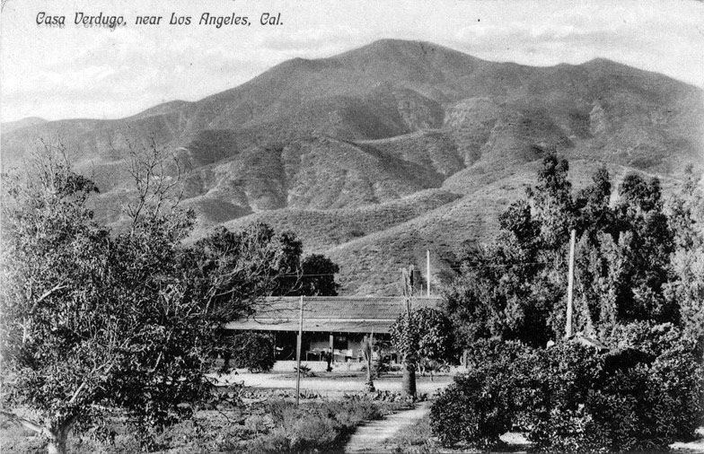
| (ca. 1905)* – Postcard view showing the Casa Verdugo (orignally Sepulveda adobe) shortly after it was converted into a restaurant. The Verdugo Mountain are seen in the background. |
Historical Notes The adobe had previously been the home of Fernando Sepulveda and his wife, Rafaela Verdugo de Sepulveda, whose father had owned the vast Rancho San Rafael. The restaurant was originally to have been called La Ramada (“The Arbor") but soon became known as Casa Verdugo after a Los Angeles reporter incorrectly identified the Adobe as the home of Teodoro Verdugo, Rafaela's nephew. The name stuck, Casa Verdugo opened on January 21, 1905, and the restaurant was an immediate success.^ |
 |
|
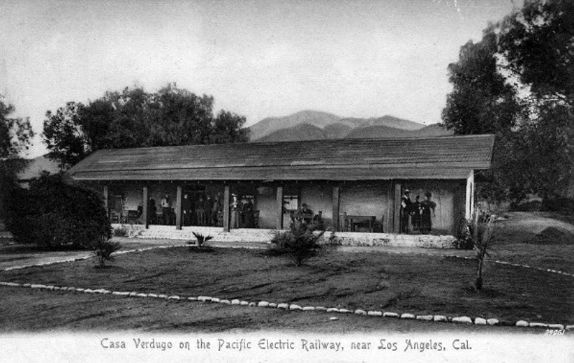
| (1905)^ – Postcard view showing the original Casa Verdugo Restaurant the year it opened. |
Historical Notes Leslie C. Brand and Henry E. Huntington purchased hundreds of acres of what had been the famous and vast Rancho San Rafael which included the Casa Verdugo adobe. They decided to remake the old house into a tourist destination in the form of a restaurant specializing in Spanish dishes intended to delight the tourists and give them a real “taste” of old California in the most literal sense of the word.^ |
 |
|
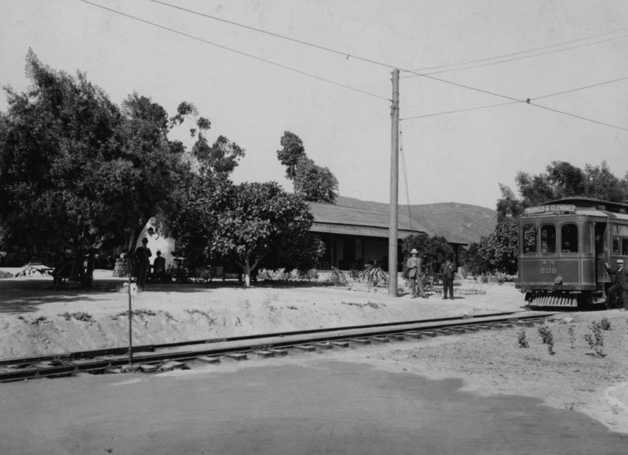
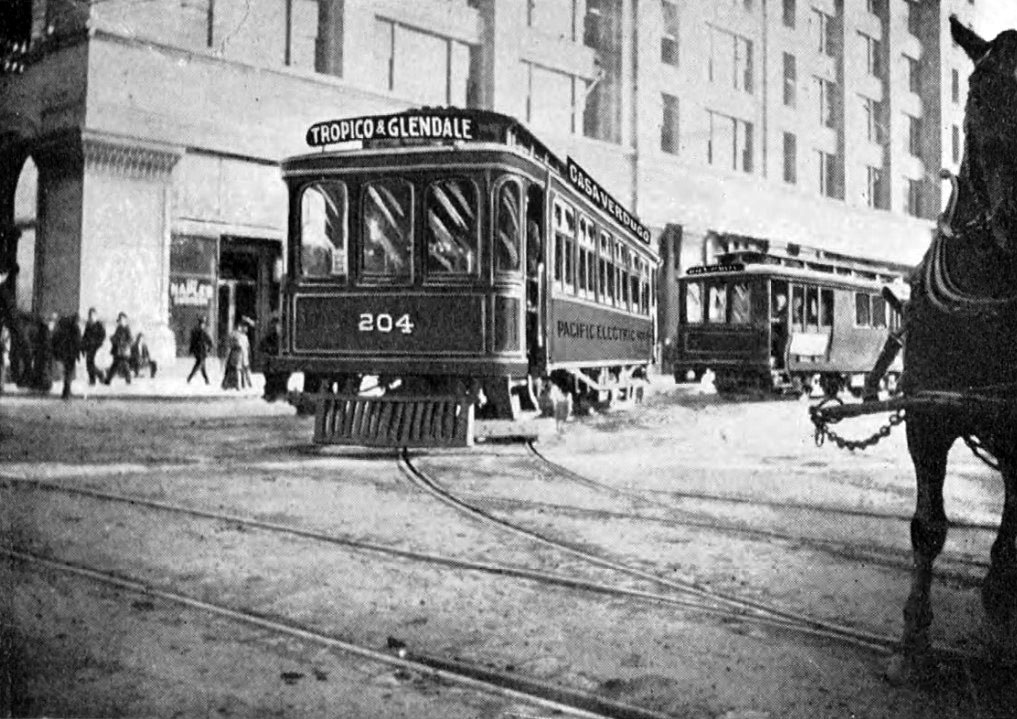
| (ca. 1905)^ – View showing a "Tropico & Glendale" electric streetcar outside Casa Verdugo adobe in Glendale. The conductor stands outside of his electric car on the right with the tracks in front of him leading to the left foreground. Two more men stand next to an electrical pole at center while others sit under the shade of trees at left. The adobe can be seen through the trees. |
Historical Notes In 1905, the Casa Verdugo restaurant opened in the Sepulveda Adobe, operated by Piedad Yorba Sowl. Brand and Huntington recruited Mrs. Sowl due to her experience in the restaurant industry. Her first restaurant, El Famoso, also served authentic dishes of Mexican origin. The restaurant capitalized on the romanticized image of Old California that became widely popular during the late 19th century. Casa Verdugo quickly became an early tourist attraction in Glendale as evidenced by local ads and postcards of the restaurant. The area around it became a popular destination as evidenced by the growth of the population of Casa Verdugo area in 1910 from 1,200 to 1,500 persons.* To make the old adobe accessible to the tourists, Huntington arranged for his Pacific Electric Railway to extend up Brand Boulevard, adding a terminus station at the entrance to the restaurant and its surrounding park, which was named “Casa Verdugo” in honor of Maria Sepulveda’s great-grandfather, Jose Maria Verdugo, the original “Don” of Rancho San Rafael. |
 |
|
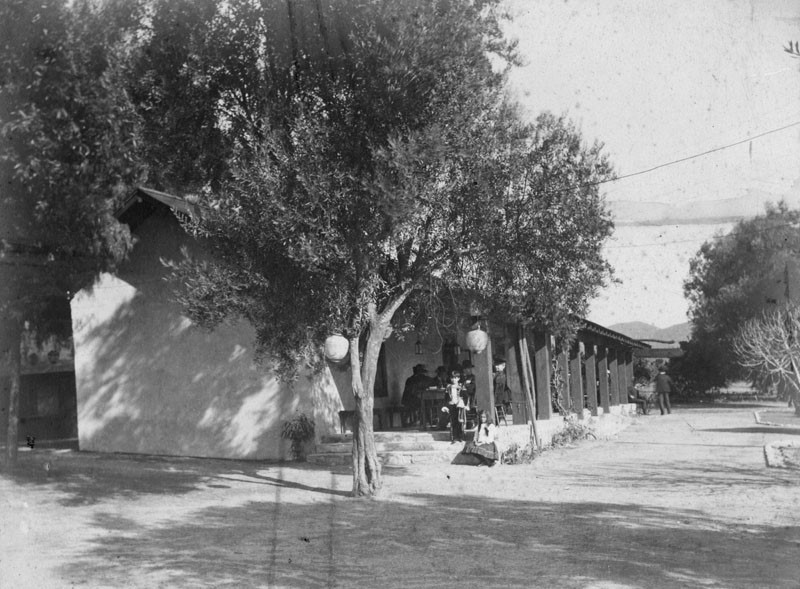
| (ca. 1905)^ – View showing the Casa Verdugo Restaurant behind a couple of pepper trees. Several people can be seen sitting at a table. |
Historical Notes Surrounded by pepper trees and other mature vegetation, the picturesque old adobe had a commanding vista towards downtown Los Angeles from its wide sheltering corridor that ran the entire length of the long narrow facade. |
 |
|
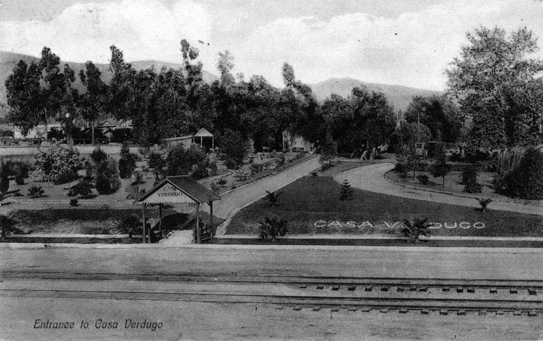
| (ca. 1905)* - Postcard view of entrance to the Casa Verdugo restaurant in Glendale. Olive trees are seen in background. Railroad tracks are seen in foreground. |
Historical Notes Huntington and his development syndicate expended thousands not only on the adobe itself, but in transforming the surrounding acres into a lush park with meandering pathways winding their way around exotic plantings including varieties of cacti and a fragrant grove of oranges that was intended to represent the type of gardens found in the old California days.^ |
 |
|
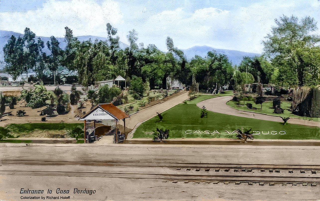
| (ca. 1905)* - Postcard view of entrance to the Casa Verdugo restaurant in Glendale. Olive trees are seen in background. Railroad tracks are seen in foreground. Image enhanced and colorized by Richard Holoff |
 |
|
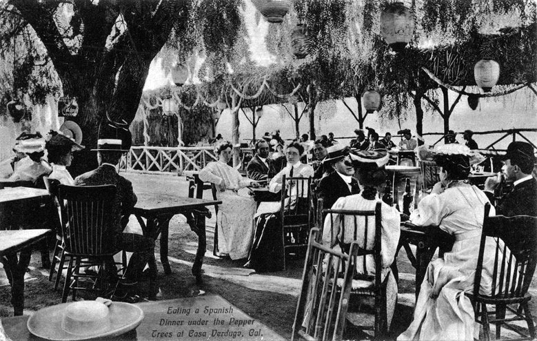
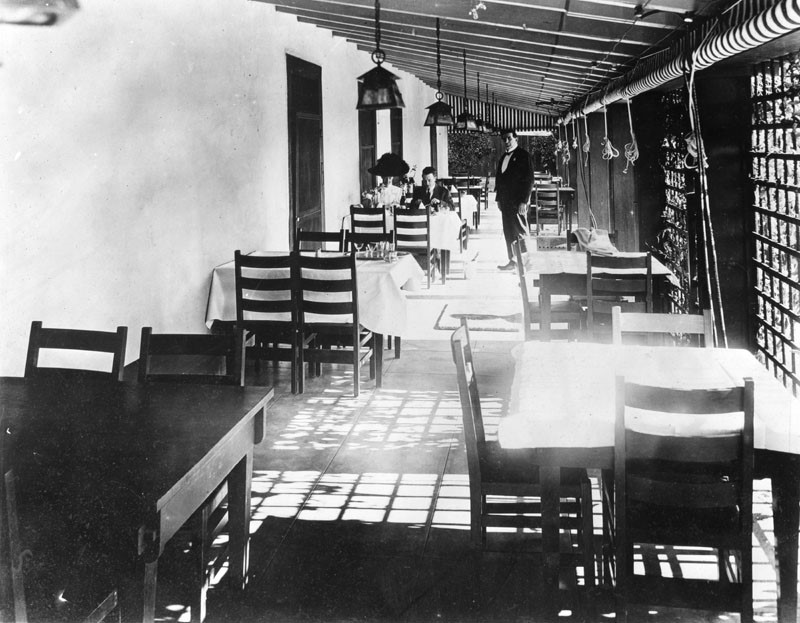
| (ca. 1905)* - Eating a Spanish dinner under the pepper trees at Casa Verdugo. View of men and women dining outside at the Casa Verdugo restaurant in Glendale. Lanterns are seen hanging above diners. |
Historical Notes From the time of its opening in early 1905, the Casa Verdugo was a big hit. Heavily advertised by the Pacific Electric, the Casa Verdugo rode the crest of the wave of public fascination with the romantic days of California’s Spanish and Mexican past and visitors made their way in droves “Out Glendale way” to partake in a Spanish dinner and stroll about the lush grounds. During its heyday, Casa Verdugo regularly entertained hundreds and sometimes even thousands of visitors at a time including a memorable 1907 Shriners outing that brought 5,000 visiting potentates to the old adobe.^ Within a few years of the restaurant opening a small community had developed and called itself Casa Verdugo after the restaurant. A commercial district grew along Brand Boulevard and Central Avenue, including a department store, groceries, a meat market, hardware store, drug store, the Mission Theatre and a post office where tourists could have their picture postcards of the restaurant postmarked “Casa Verdugo, California.” The droves of tourists, and the postcards they mailed home, helped make Casa Verdugo a well-known destination throughout the country; visitors had to see the missions, the Mt. Lowe Railway, Santa Catalina Island and the famous Casa Verdugo. |
 |
|
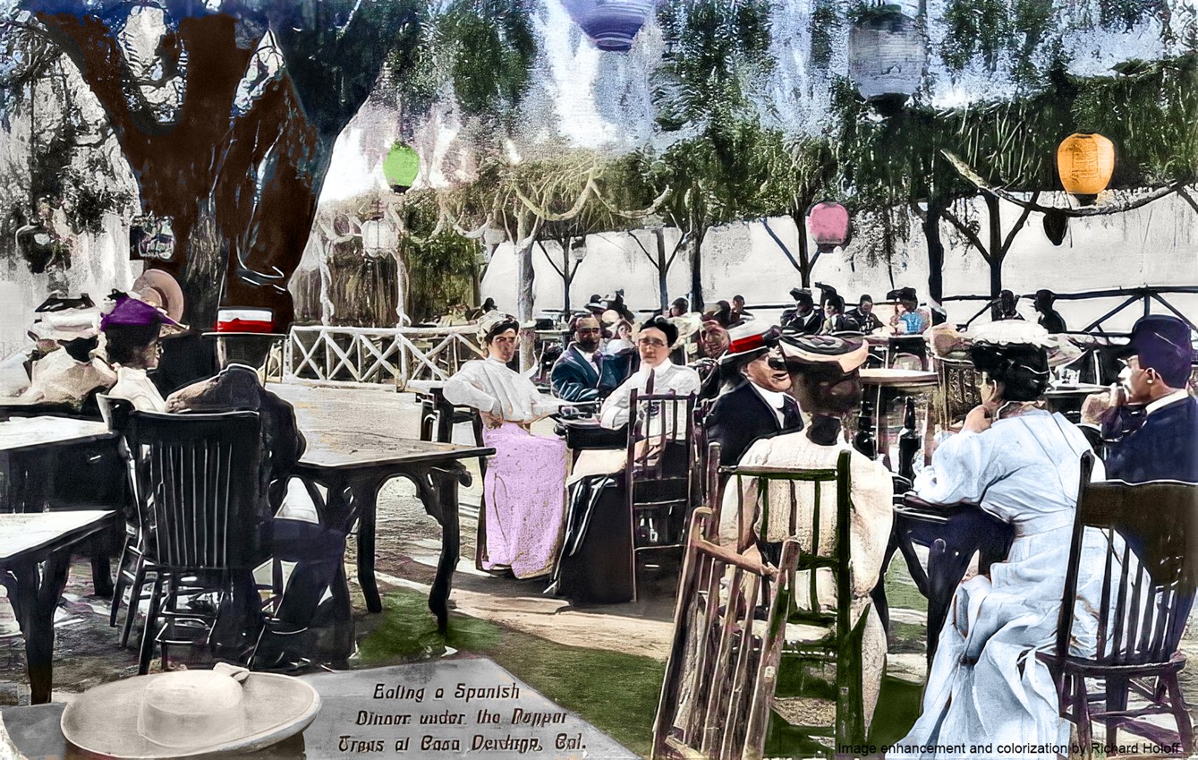
| (ca. 1905)* - Eating a Spanish dinner under the pepper trees at Casa Verdugo. View of men and women dining outside at the Casa Verdugo restaurant in Glendale. Lanterns are seen hanging above diners. Image enhancement and colorization by Richard Holoff |
 |
|
| (n.d.)* - Diners at the Casa Verdugo Restaurant with a waiter standing nearby. |
Historical Notes Both the food and the setting were real treats. Diners could enjoy their peppery selections in a variety of inviting locations, from the fireplace-warmed main sala with its thick adobe walls and old beamed ceiling festooned with strings of red peppers to al fresco settings under venerable pepper trees or vine-covered bowers. A most popular spot was, no doubt, the wide veranda where the pleasure of a sunset dinner was enhanced by the heady scent of orange blossoms wafting through the dusky air. Although its setting was charming in the extreme, Casa Verdugo’s true success was the result of its exceptional proprietress, Piedad Yorba de Sowl, whom Huntington and Brand had wisely granted a five-year lease to run the property upon its opening in 1905. Under de Sowl, Casa Verdugo rapidly became a “must do” for anyone visiting Southern California. In 1910, because of a disagreement with de Sowl, the Pacific Electric would not renew her lease and hired another proprietor. de Sowl, however, had both trademarked and copyrighted the name “Casa Verdugo” and now claimed infringement. A nasty court battle followed, which de Sowl decisively won in 1911 and the Pacific Electric was forced to suck lemons and come up with a new name. They ultimately settled on “La Ramada”. de Sowl opened a "New" Casa Verdugo Restaurant in her nearby residence and over the next decade the two restaurants operated side by side in an uneasy truce, but one clearly favored by de Sowl. In evicting de Sowl, the Pacific Electric had naively thought people had come to Casa Verdugo to see a building. They hadn’t. They came for an experience, and de Sowl was the one who provided it.^ On May 1, 1923 the original Casa Verdugo Restaurant (formerly the Sepulveda adobe), located in what is now the 1200 block of North Maryland Avenue, was demolished. |
Casa Verdugo Segunda
 |
|
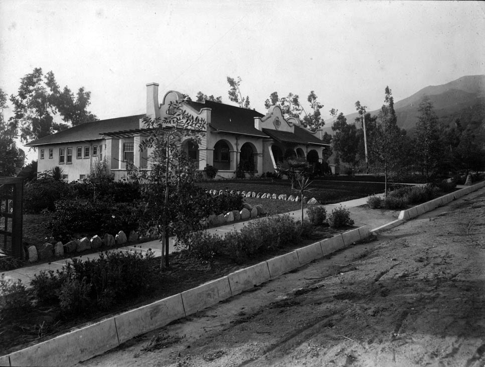
| (ca. 1907)^^ - View showing the Mission Revival-style home of Piedad Yorba de Sowl before it was transformed into the new Casa Verdugo Restaurant. |
Historical Notes Because of her success at the original Casa Verdugo Restaurant, Senora Piedad Yorba de Sowl and her husband Charles had been granted by a then grateful Pacific Electric the northeast corner of the Casa Verdugo property where, in 1907, they built a beautiful Mission-styled home, which the couple dubbed “Soledad.” In 1910, when de Sowl could not get an extension of her lease at the original Casa Verdugo Restaurant because of a disagreement with Pacific Elelctric, she simply reopened “Casa Verdugo” in her former dwelling, taking the staff and most all of the patrons with her, and which she pointedly advertised as “not the railroad place.” |
 |
|
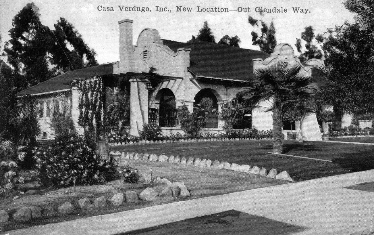
| (1910)^v^ – "New Location--Out Glendale Way". Postcard view showing the ‘New’ Casa Verdugo Restaurant. |
Historical Notes When Piedad Yorba Sowl moved her restaurant around the corner (literally) after the Pacific Electric Railway declined to renew her lease in 1910, she had a set of postcards printed featuring the new location. This is the first one. |
 |
|
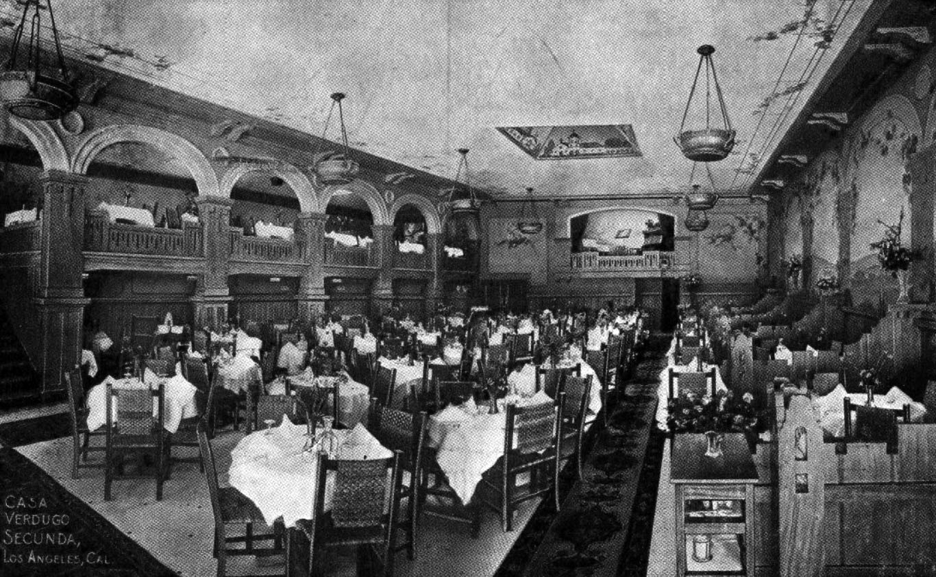
| (ca. 1914)** – Postcard view showing the interior dining area of the Casa Verdugo Segunda. |
Historical Notes Piedad Yoba de Sowl’s new Casa Verdugo brought the same charms that were so successful to Casa Verdugo vieja. As before, diners could choose indoor or al fresco dining. Those choosing indoor seating had their choice of a series of charming spaces, each with its own unique name and personality such as the Indian, the Red or the Green Room. And to make sure diners didn’t have to rely on the hated Pacific Electric to visit the Casa, de Sowl had a beautiful garage constructed, that housed any number of visiting machines in Mission-styled splendor. Piedad Yoba de Sowl was such a success she opened a “Casa Verdugo Segunda” at 736 South Spring Street in 1913 so diners in downtown Los Angeles could enjoy the same style food and service found “Out Glendale Way.” Operating in this location until April of 1921, de Sowl and the Pacific Electric both sold out to a consortium of three school teacher sisters, Ida , Jeannette and Myrtle Baldwin from Dayton, Ohio. The combined transaction for the two properties being described as the largest real estate deal to date in Glendale area for the considerable sum of $100,000. The Casa Verdugo name remained a potent one in L.A. restaurant up into the 1960’s. By that time, however, Piedad Yorba de Sowl had long passed, dying at the age of 84 in 1948. Her former home and restaurant, however, has survived, an accomplishment as remarkable as the woman herself, and remains today a treasured landmark in northern Glendale (1235 North Louise Street at the corner of Randolph).^* Click HERE for contemporary view. |
Casa Adobe de San Rafael
 |
|
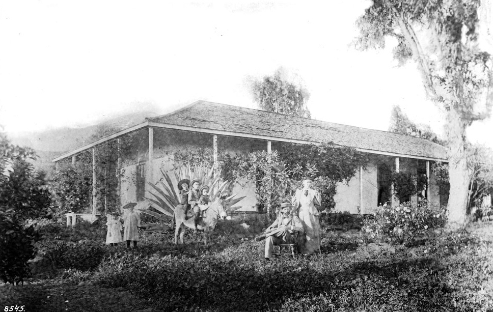
| (1895)^^ - Photographic portrait of Charels and Nellie Bogue in front of the former home of Tomas Sanchez in Glendale. The one-story adobe, located on the back of the Verdugo Ranch one half-mile west of Brand Boulevard, is shown at center, featuring a wrap-around patio and overhang. In the yard in front, Charles is shown seated to the left with Nellie standing at his side. At center, three boys in bolero dress identified as the children of "Charles and John" sit astride a burro while two girls identified as "Ruth and Helen" are pictured in lightly colored dressed farther left. Sanchez lived at the residence between 1872 and 1875. |
Historical Notes In October 1784, José María Verdugo petitioned Pedro Fages, Governor of Alta California, for a grant of land. This grant was the first and one of the largest made. When parts of Rancho San Rafael were sold, Tomás Sánchez, Sheriff of Los Angeles County, purchased a tract of 100 acres and in 1865 built this artistic adobe of the hacienda type, restored in 1932. |
 |
|
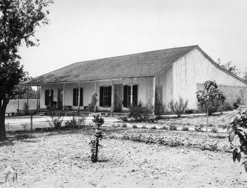
| (1936)^ - Exterior view of the Tomas Sanchez adobe, La Casa Adobe de San Rafael, Glendale, in June 1936, following restoration in 1932. The photo shows its Monterey-style corridor (covered porch). It was built by Tomas Sanchez, sheriff of L.A. County, in 1849 on Rancho San Rafael land owned by Fernando and Rafaela Verdugo. |
Historical Notes Casa Adobe de San Rafael has been designated a California Historical Monument (No. 235). It is located in a city park and is now furnished with furniture, cooking utensils and other relics of its time. Location:1330 Dorothy Dr, Glendale. |
Glendale Hotel (later Glendale Sanitarium, Glendale Adventist Health Center)
 |
|
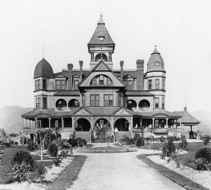
| (1895)* - View showing the Glendale Hotel, shown here when it was a school for girls. It was located on what is now Broadway Avenue. |
Historical Notes During the area's first little boom, the Hotel Glendale was built at a cost of $60,000 in 1887-1888. It was a grandiose structure, but it didn't even open! The boom busted too fast, and the hotel became a school (St. Hilda's Hall, School for Girls). It later became the Glendale Sanitarium until 1924 when the building was razed.* |
.jpg) |
|
| (1895)* - View showing the Glendale Hotel, shown here when it was a school for girls. It was located on what is now Broadway Avenue. Image enhancement and colorization by Richard Holoff |
 |
|
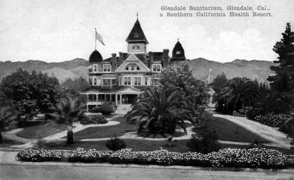
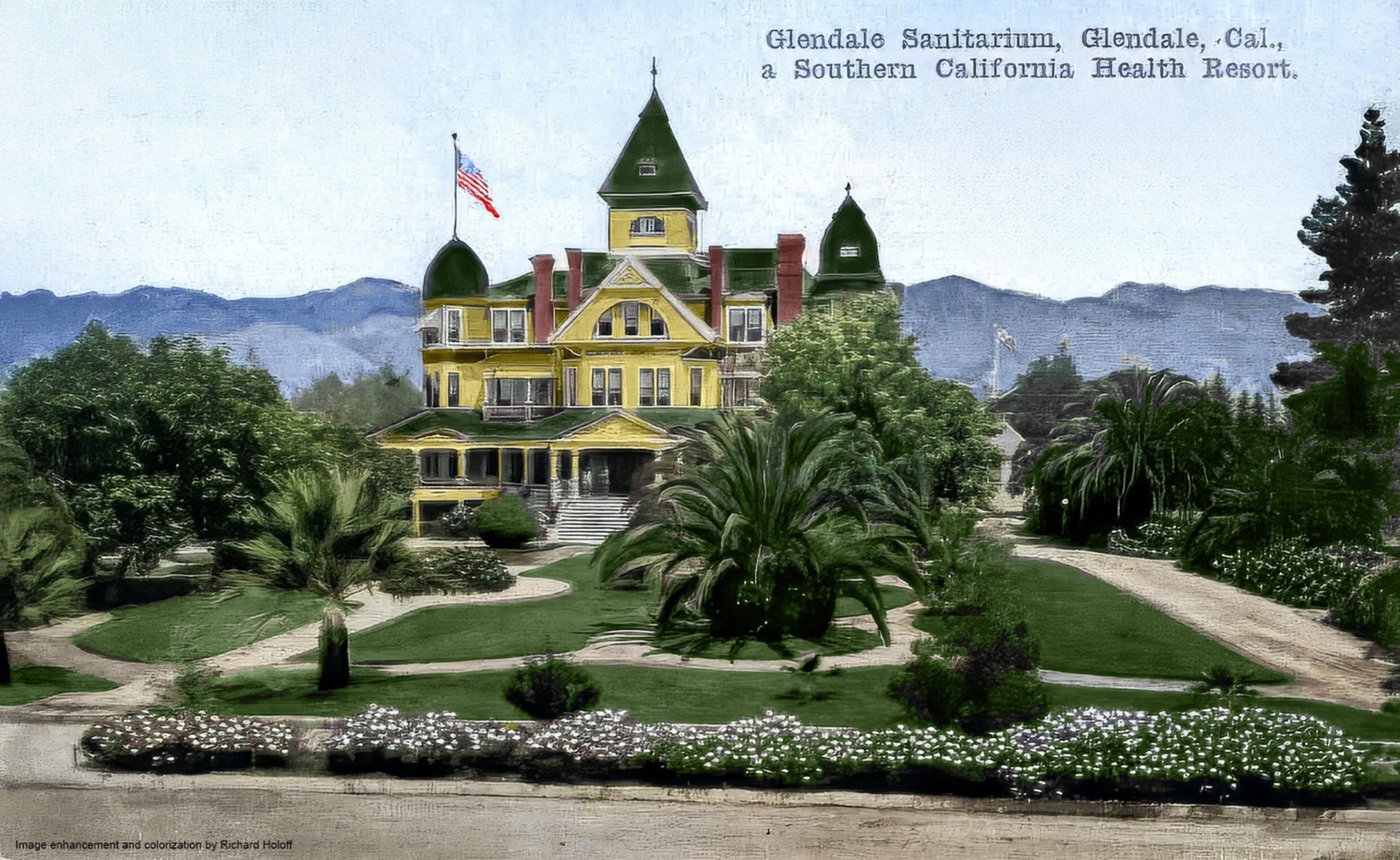
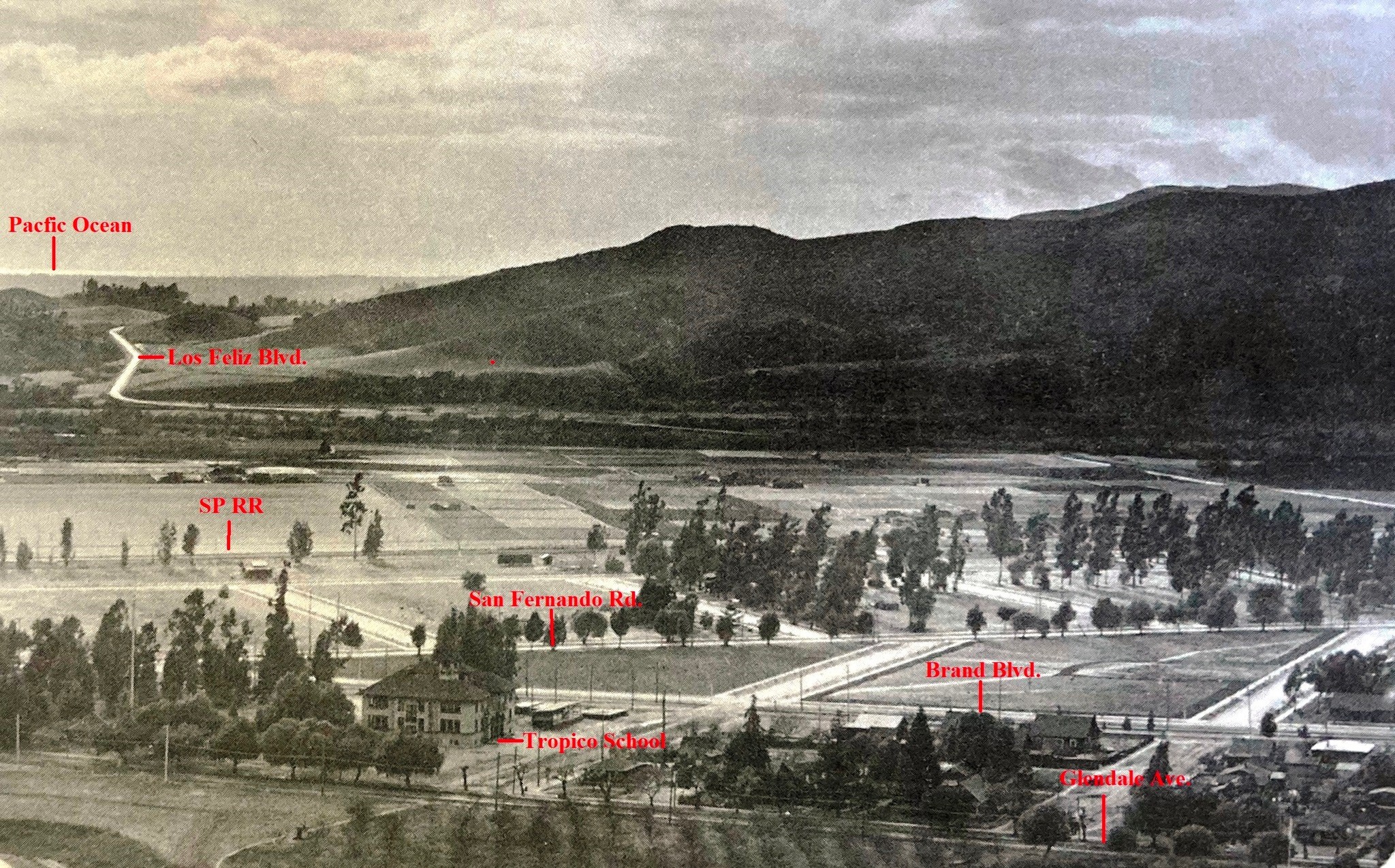
| (ca. 1910)* – View looking at the Glendale Sanitarium with the Verdugo Mountains in the background. Title reads: “Glendale Sanitarium…a Southern California Health Resort” |
Historical Notes Glendale Sanitarium opened in 1905, a year before Glendale was incorporated as a city. It occupied the beautiful 75-room Victorian structure (Hotel Glendale) and stayed until moving out in 1924 to a new location at 1509 Wilson Terrace. There it evolved into the well-known Glendale Adventist Health Center that exists today. |
 |
|
| (ca. 1910)* – View looking at the Glendale Sanitarium with the Verdugo Mountains in the background. Title reads: “Glendale Sanitarium…a Southern California Health Resort”. Image enhancement and colorization by Richard Holoff |
* * * * * |
Casa Verdugo Community
 |
|
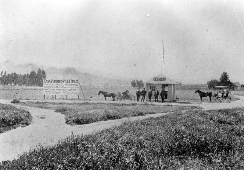
| (ca. 1900)^ - Panoramic view of a real estate development sign and office, with horses and carriages. The development is called "Casa Verdugo Villa Tract" and is offered by San Rafael Investment Company. |
Historical Notes CCasa Verdugo was originally a part of the Rancho San Rafael land grant that was given to Jose Maria Verdugo in 1784. Verdugo’s granddaughter, Rafaela Verdugo de Sepulveda, subsequently owned the land after the Great Partition in 1871. In 1883 the real estate firm Wicks, Wright, Hodgkins, and Watts purchased 500 acres of land from Valentine Mand, which included the Sepulveda Adobe. A portion of the property was sold to clergyman George Baugh in 1886 who subdivided the tract and lived in the Sepulveda Adobe with his family. In 1900, Baugh sold the property to J.D. Bliss who with the help of his brother operated Bliss Ranch on the property. Finally, in 1903 Leslie Brand, who would become a civic leader in Glendale, purchased Bliss Ranch and 175 acres of surrounding land. In 1904, Brand sold a stake of the tract to Henry Huntington, the owner of the Pacific Electric Railway Company. This resulted in the creation of the Glendale line that ran from downtown Los Angeles to Broadway in Glendale. At the time, the Los Angeles Interurban Railway served as the operator, which was later succeeded by the Pacific Electric Railway. In November 1904, the line was extended a half-mile north along Brand Boulevard to Mountain Street.** |
The 'Red Car' comes to Glendale
 |
|
| (1906)^ - View showing one of the Pullman “Flyers” of the Pacific Electric Railway Co. leaving the grand depot, 6th and Main streets, on one of the regular thirty-three daily trips to Casa Verdugo. Photo was published in a real estate promotional brochure put out by San Rafael Investment Co. |
Historical Notes The Glendale Line was pioneered by L.C. Brand and associates starting in October, 1902, through their corporation, "The Los Angeles & Glendale Electric Railway". On June 29, 1903, Brand received a franchise from the Los Angeles City Council for an electric railway line running from Los Angeles to Glendale. The franchise was soon sold to Henry E. Huntington, owner of Pacific Electric Railway Co., who would bring the "Red Cars" to Glendale by 1904 under the name of Los Angeles Interurban Railway (later changed to Pacific Electric). A 1906 San Rafael Investment Co. and Pacific Electric Railway promotional brochure reads: The fame of this ride, decidedly the most picturesque to any suburb, attracts thousands of tourists, requiring many additional cars on Sundays and holidays, while the hundreds of commuters going daily to and from business and home are rapidly increasing in numbers. The passage through the city, passing Central Park, traversing Figueroa Street, Lake Shore Drive (today, Glendale Blvd.), skirting Echo Park, through Edendale and the Pass between Elysian and Griffith Parks to the point where the most enchanting of all valley panoramas burst upon the view, is accomplished in fifteen minutes. The scene is framed on the north, in ascending order, by the San Rafael hills, Verdugo mountains and the San Gabriel range, showing Mts. Lowe and Wilson in the foreground, while far to the east Mt. Cucamonga’s dome and the other snow-capped peaks of the San Bernardino mountains rising eight thousand and nine thousand feet are discovered. The flight along the borders of Griffith Park, over the trestles spanning Los Angeles River, and through Tropico to the fine depot at Brand Boulevard and Fourth Street (today, Broadway), Glendale occupies but ten minutes. Here, midway the broad valley, its beauties and surpassing advantages are fully realized. But five minutes are required for the remainder of the trip down the center of Brand Boulevard, a thoroughfare 130 feet in width, flanked by seventy-two monoliths, eleven and one-half feet high, capped by electric lights, with the space between the broad cement walks and curbs filled by graceful palms, on to Mountain Avenue. Here at the end of the line is found the choicest residential portion of the valley, at the foothills. This is not a picture of a dissolving view, but one as eternal as the everlasting hills.* |
 |
|
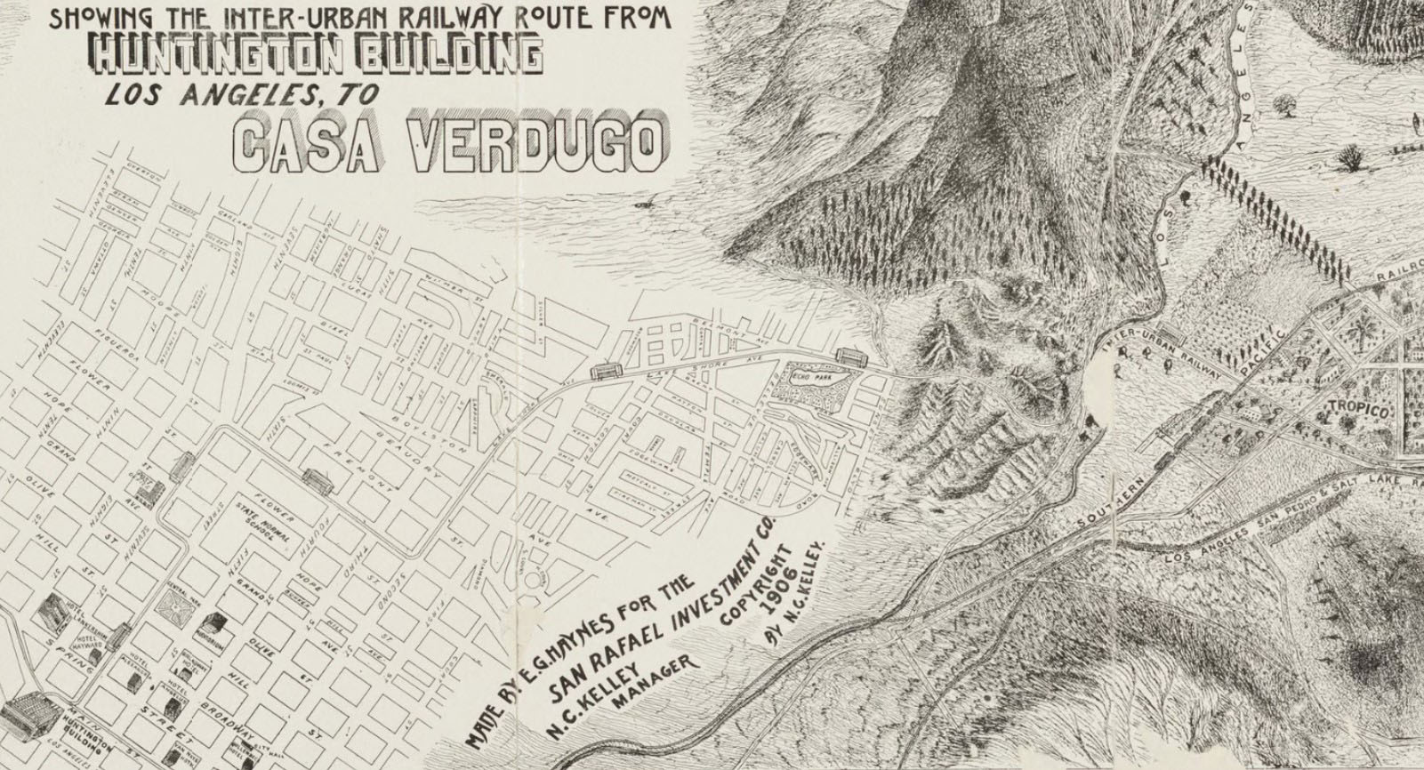
| (1906)^ – Map showing the Inter-Urban Railway route from the Huntington Building (aka Pacific Electric Building), located at 6th and Main streets, to Casa Verdugo at Brand Blvd and Mountain Ave. |
Historical Notes The Inter-Urban streetcar route began at the Huntington Building (aka Pacific Electric Building) in downtown Los Angeles, passing Central Park, traversing Figueroa Street, Lake Shore Drive (today, Glendale Blvd.), skirting Echo Park, through Edendale and the Pass between Elysian and Griffith Parks, over the trestles spanning Los Angeles River, through Tropico and then down the center of Brand Boulevard to the depot at Brand Boulevard and Fourth Street (today, Broadway), and finally further north on Brand to the end of the line at Mountain Avenue, the location of Casa Verdugo. |
 |
|
| (1904)* - Panoramic view looking north toward Glendale along the Pacific Electric line through the Edendale Cut. |
Historical Notes The Edendale Cut was an unpaved road (some of which is now known as Silver Lake Ct.) and was the former route of the Glendale and Burbank interurban railway lines operated by Pacific Electric. The line crossed Fletcher Drive over a viaduct before continuing along a hillside ledge to the Monte Sano stop at Glendale Blvd. and Riverside Drive. |
 |
|
| (1904)* - Panoramic view looking north toward Glendale along the Pacific Electric line through the Edendale Cut. Image enhancement and colorization by Richard Holoff. |
Historical Notes The Edendale Cut was part of the Pacific Electric's Glendale-Burbank Line, which had one terminus in Downtown LA and the other in Burbank, passing through Edendale/Silver Lake along the way. The cut was a deep trench carved through the hills to allow the rail line to pass through the area without steep grades. Homes and other buildings lined the sides of the cut, with the rail line running through the bottom. In 1960, many of these homes were demolished to make way for the construction of the Glendale (2) Freeway, which followed a similar route through the cut. Today, remnants of the old rail line like bridge footings and dirt paths can still be seen in the area, serving as reminders of LA's once-extensive rail network. |
 |
|
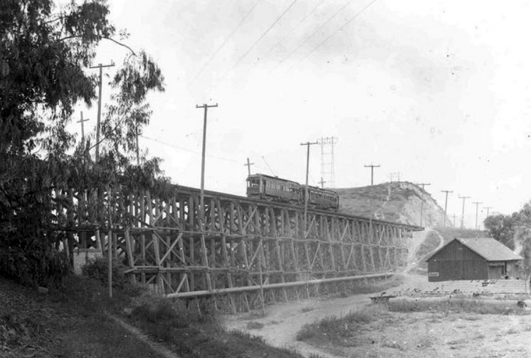
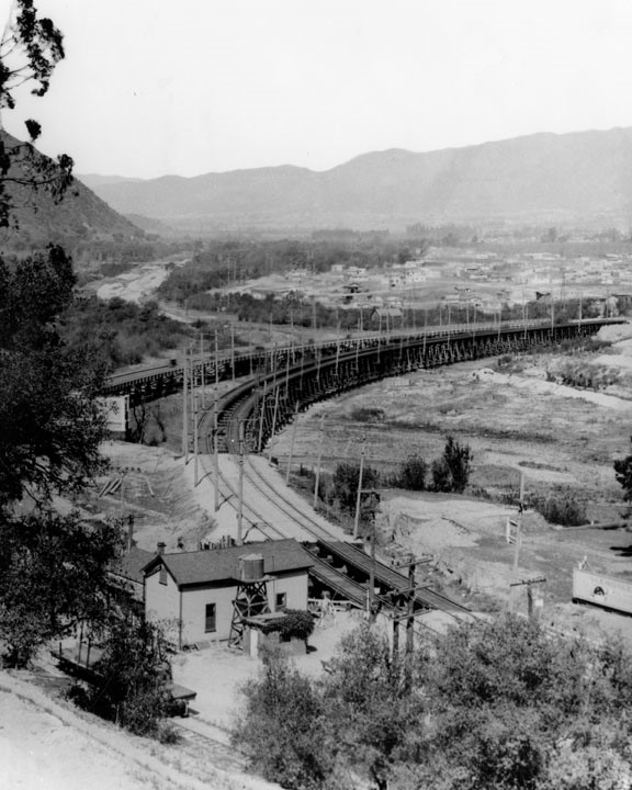
| (Early 1900s)^ – View showing two PE cars of the LA-Glendale Interurban Railway (owned by Pacific Electric) on top of the Fletcher Drive timber bridge. |
Historical Notes In 1904, a nearly 454 foot long bridge, the Fletcher Viaduct, was built by Pacific Electric over Fletcher Drive, which ran forty feet below. The viaduct stood until 1928 when it was replaced by a steel structure bridge. Click HERE to see more. |
 |
|
| (Early 1900s)^ – View looking towards the Pacific Electric LA-Glendale Interurban bridge at Glendale Boulevard running over the Los Angeles River, showing Griffith Park (left), Atwater Village, Tropico and Glendale. |
 |
|
| (1906)^* – Birdseye view of Casa Verdugo Villa Tract and streetcar route which terminated at Brand Boulevard and Mountain Avenue, in front of the Casa Verdugo Restaurant. |
Historical Notes As a result of transportation innovations and the success of the restaurant, a commercial district was created in the Casa Verdugo neighborhood at the corner of North Central Ave. and West Stocker St. A theatre, various stores, a school, and a post office were established in the area, providing a solid economic foundation and increasing population growth that spurred residential construction. A flurry of developers, companies, and individuals participated in the purchase and subdivision of tracts in Casa Verdugo. The development of Casa Verdugo was not the effort of any single developer or builder, but rather a number of individuals who produced a network of various tracts. Real estate investor James Wyvell played an active role in the subdivision and development of the neighborhood. From 1906 to 1908, Wyvell subdivided and sold a number of tracts both within and surrounding the proposed district. This included land adjacent to the Casa Verdugo restaurant property and lots sold as home sites to individuals. Wyvell’s own Casa Verdugo tract and the Casa Verdugo Villa tract spoke to the growing identity of Casa Verdugo as its own distinct community. ^^ Within a few years of the Casa Verdugo restaurant opening a small community had developed and called itself Casa Verdugo after the restaurant. A commercial district grew along Brand Boulevard and Central Avenue, including a department store, groceries, a meat market, hardware store, drug store, the Mission Theatre and a post office where tourists could have their picture postcards of the restaurant postmarked “Casa Verdugo, California.” The droves of tourists, and the postcards they mailed home, helped make Casa Verdugo a well-known destination throughout the country; visitors had to see the missions, the Mt. Lowe Railway, Santa Catalina Island and the famous Casa Verdugo. ^ |
Bliss
 |
|
| (1909)* - All Aboard! Bliss to Los Angeles Line, 1909. Note the woman with the long white dress and huge hat. Also, the grill at the front (aka 'Cow Catcher'—it was a protective measure to prevent anyone (or anything) from falling underneath. |
Historical Notes Bliss was named for Bliss Ranch, owned by brothers John Dallett Bliss and Robert Parker Bliss from about 1894 to 1900, when LB Brand bought the property. He then sold a tract to Huntington for Pacific Electric. The Bliss stop was at the base of the Verdugo mountains, just after the Casa Verdugo stop (corner of Brand Boulevard and Mountain Street). |
 |
|
| (Early 1900s)+^^ - Old rail map showing the Bliss Station located om north Glendale, today's intersection of Brand Boulevard and Mountain Street (concrete base is still there). |
 |
|
| (1912)#* – Panoramic view of Glendale, looking west from Jackson Street, showing the extent to which the area had grown. |
Historical Notes Glendale, the Casa Verdugo community, and surrounding area experienced a significant growth spurt beginning around 1904, due in large part to the arrival of the Pacific Electric line. Casa Verdugo held on to the unique identity that emerged during this time and refused to annex to the city of Glendale for sixteen years. Opponents desired an independent city while those in favor wanted the advantages of utilities and services offered by the larger city. In March of 1926, a vote for annexation passed and Casa Verdugo officially became a part of the city of Glendale on April 17, 1926. |
Brand Boulevard
 |
|
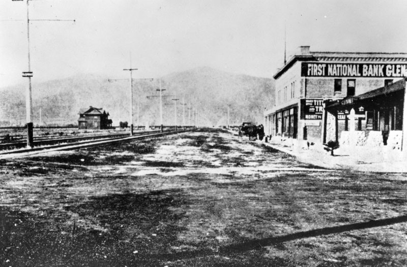
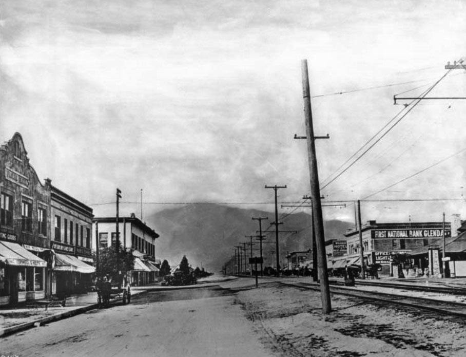
| (ca. 1905)^ - Early panoramic view looking north on Brand Boulevard at Fourth Street (later Broadway) with the First National Bank of Glendale seen at right. Rail tracks run north and south on Brand with electric power poles in the middle of the street. To the far right (N/E corner) stands the Pacific Eelctric station. |
Historical Notes Brand Boulevard was named after Leslie Coombs Brand, “The Father of Glendale”. Brand was an important civic booster who built an estate in 1904 called El Miradero featuring an eye-catching mansion whose architecture combined characteristics of Spanish, Moorish, and Indian styles (today’s Brand Library and Art Center). His most important contributions to Glendale, though, was when he partnered with Henry E. Huntington to bring the Pacific Electric Railway, or the "Red Cars," to the area also in 1904. The First National Bank of Glendale seen above was the city’s second bank. It was founded by Leslie Brand in 1905. Brand's friend and business partner, Dan Campbell, served as the bank's vice president and manager. |
 |
|
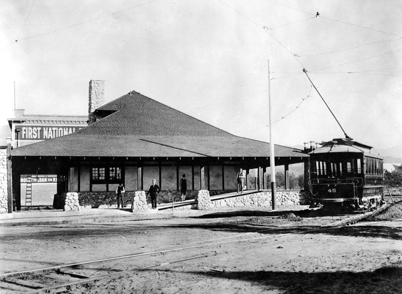
| (ca. 1906)^ - Early view of the Pacific Electric station in Glendale with car on track. First National Bank of Glendale, the first brick building in town, is seen behind the depot. |
Historical Notes The Glendale Line was pioneered by L.C. Brand and associates starting in October, 1902, through their corporation, "The Los Angeles & Glendale Electric Railway". On June 29, 1903, Brand received a franchise from the Los Angeles City Council for an electric railway line starting at the Southern Pacific's Arcade Station at Fifth, Central & Ceres Street in Los Angeles via Ceres, Sixth, Olive, Seventh, Figueroa, Second, Lake Shore Ave. (Glendale Boulevard) to Sunset Boulevard, and then northerly to the city limits. In Glendale, the line was to enter via a new thoroughfare, Brand Boulevard, thus creating a new business artery to the west of the then central business section on Glendale Ave. where the steam trains of the Los Angeles Terminal Railroad (U.P.) offered the only transportation via rail to the city. Brand's company commenced grading on above route in September, 1903 and continued into the spring of 1904. On March 11, 1904, however, Brand sold out to the Los Angeles Interurban Railway Company (LAIU), a Huntington-PE affiliate. The LAIU pushed the road through to completion and the first electric car entered Glendale on April 6, 1904, but a formal celebration was not held until July 2 when great crowds gathered for a Mexican barbecue. A Station was erected in Glendale on the corner of Brand Boulevard & Broadway (seen above).^ |
 |
|
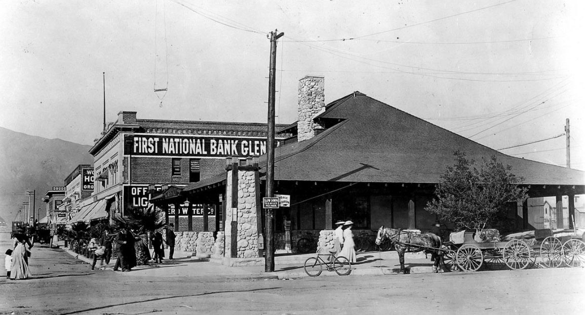
| (1911)* – Panoramic view showing the corner of Brand Boulevard and Fourth Street (now Broadway) with the Pacific Electric depot in the foreground and the First National Bank of Glendale behind it. Horse-drawn wagons and a bicyle are parked by the curb in front of the depot. |
Historical Notes The Glendale Line was soon extended east on Broadway to Glendale Avenue where all cars terminated for a short time. Los Angeles Interurban Railway Company (LAIU) acquired the historic old Verdugo ranch house, more than a hundred years old, in 1904; this was located in North Glendale at the foot of the mountains and LAIU restored the ruins, making Casa Verdugo into one of Los Angeles' most popular restaurants. To serve this new tourist attraction, the Glendale Line was extended up Brand Boulevard to Mountain Avenue in 1904 with very frequent service offered from Sixth & Main Station, Los Angeles.^ |
 |
|
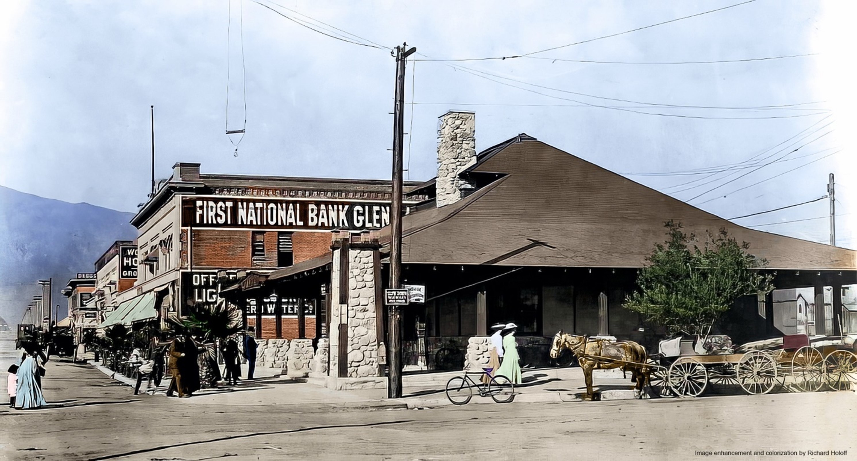
| (1911)* – Panoramic view showing the corner of Brand Boulevard and Fourth Street (now Broadway) with the Pacific Electric depot in the foreground and the First National Bank of Glendale behind it. Horse-drawn wagons and a bicyle are parked by the curb in front of the depot. Image enhancement and colorization by Richard Holoff |
 |
|
| (ca. 1910)^^ – View looking north in the 400 block of Brand Boulevard, Glendale. Railway tracks and electric wires run up the middle of the dirt road. Commercial structures on both sides of the street are principally two-stories in height. Horse-drawn wagons are parked along both curbs. First National Bank Glendale can be see at right. |
 |
|
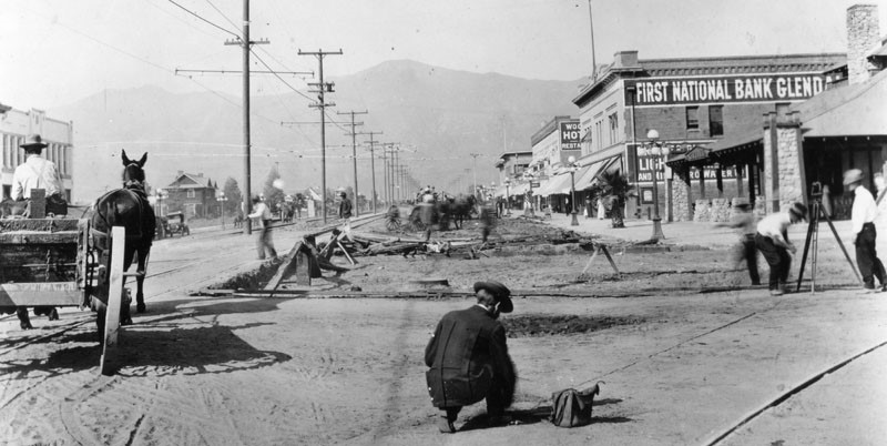
| (ca. 1910s)^ - View is looking at Brand Boulevard, north of Broadway. Work is being done on the right side of the road. Several businesses are seen including the First National Bank, Glendale building on the right. |
 |
|
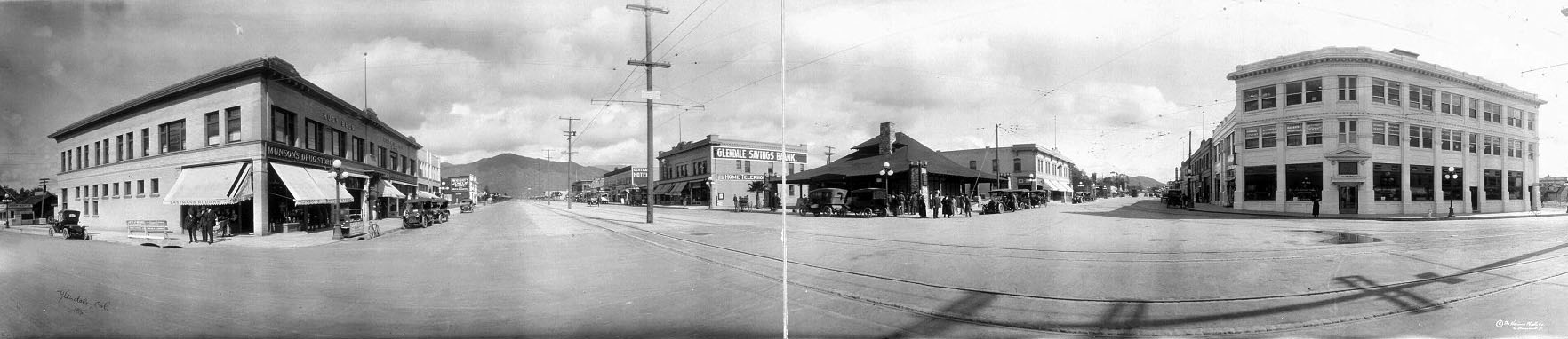
| (ca. 1915)^ - Panoramic view of Glendale showing the Pacific Electric Railway running north and south on Brand Boulevard with Glendale Savings Bank (previously First National Bank Glendale) on at center-right. |
 |
|
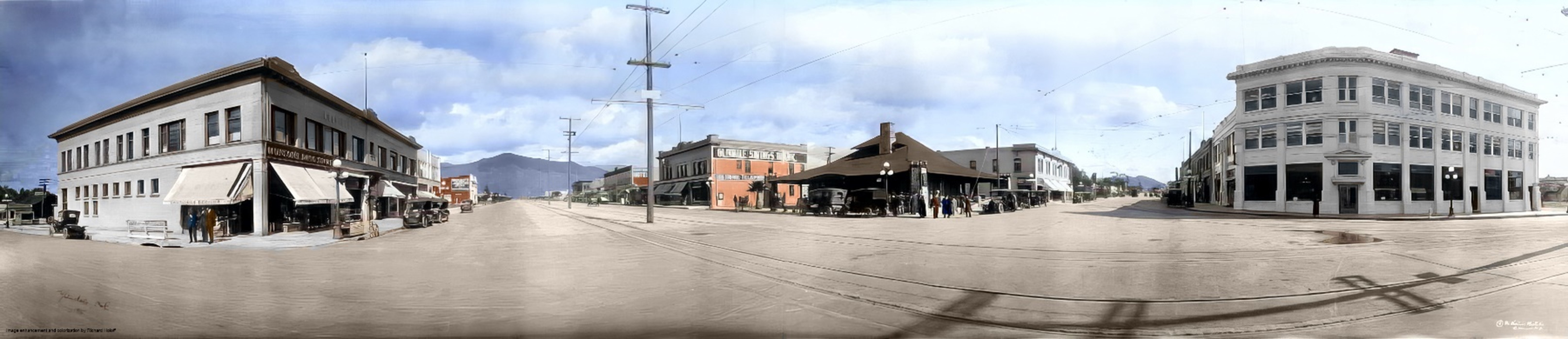
| (ca. 1915)^ - Panoramic view of Glendale showing the Pacific Electric Railway running north and south on Brand Boulevard with Glendale Savings Bank (previously First National Bank Glendale) on at center-right. Image enhancement and colorization by Richard Holoff |
 |
|
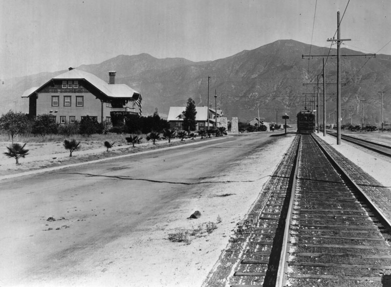
| (1915)^ - View of north Brand from Lexington. The railroad train, "Los Angeles line" makes its way up Brand. Large residential homes can be seen on the left. |
 |
|
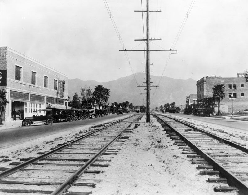
| (1919)^ - View of Brand and Lexington and the surrounding area. The Glendale Press building is on the left. The train in the distance is stopped to pick up passengers waiting along the way. |
 |
|
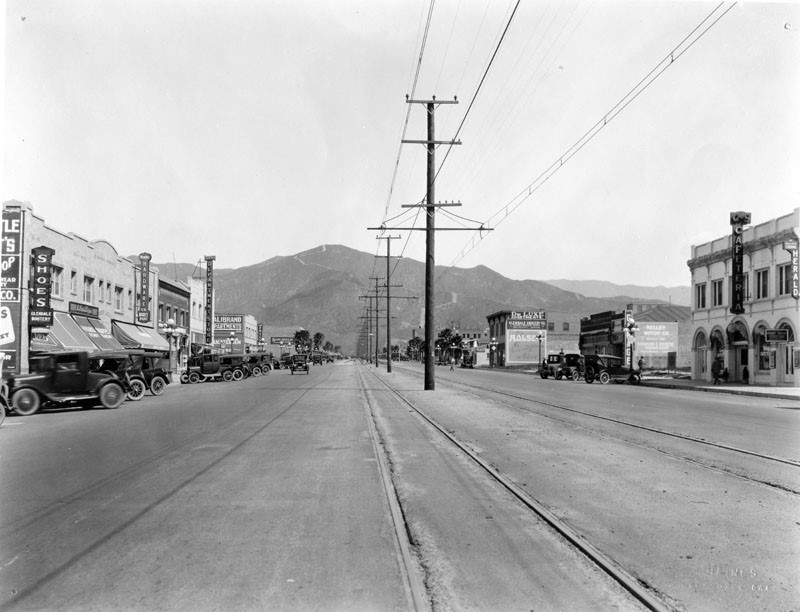
| (ca. 1919)^ – View of Brand Boulevard from Wilson Avenue, looking north. Various businesses are seen on both sides of the road with railroad tracks running down the center of this wide street. |
 |
|
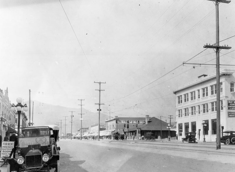
| (ca. 1920)^ – View looking north on Brand from Broadway. Glendale Savings Bank (previously First National Bank) can be seen in the distance. Electric car posts and wires fill the middle of the street. |
Then and Now
 |
|
| (1911 vs 2022)* - Looking north on Brand Boulevard at Broadway. |
 |
|
| (1915 vs 2022)* - Looking north on Brand Boulevard from Lexington Drive. |
Historical Notes Click HERE to see more Early Views of Brand Boulevard (1920 +) |
Life in Early Glendale
 |
|
| (1908)^ - A picnic for the Concordia Club, a social group, at Verdugo Park in Glendale. |
 |
|
| (1910)^ - Three women and two men standing in front of the Glendale Theater. This is Glendale's first movie & vaudeville house. |
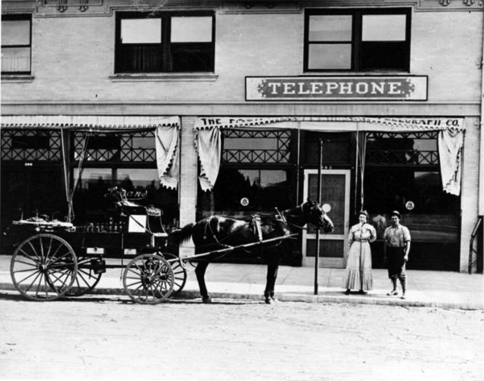
| (ca. 1906-1918)***^ - The Glendale Transfer and Express Company's moving truck in Glendale. |
Historical Notes Note the two phone numbers at the top of the truck (S.S. 82 and HOME 682). Between 1906 and 1918, the San Fernando Valley Home Telephone Company and Sunset Telephone both operated in the Glendale area. Unfortunately, neither was compatible with the other therefore requiring patrons to have two lines--one for each company. |
 |
|
| (1914)***^ - View showing the Home Telephone Company office, located at 302 Brand Boulevard in Glendale. A state-of-the-art telephone maintenance vehicle is visible in the foreground. |
Historical Notes In 1909, L. C. Brand invested heavily in the Home Telephone Company and installed new switchboards in company office at the Central Hotel Building on Brand Boulevard.***^ |
 |
|
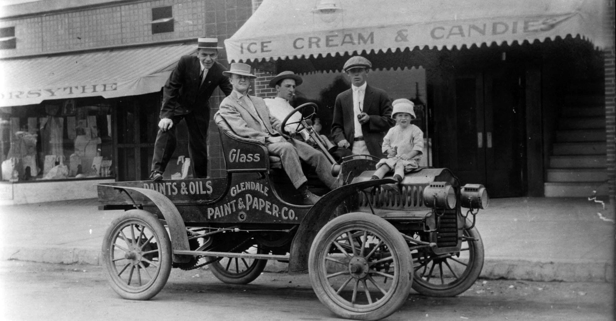
| (1913)+++ – View showing a group of men and a child posing on an early model car in Glendale. Sign on the side of car reads: “Glendale Paint & Paper Co. |
 |
|
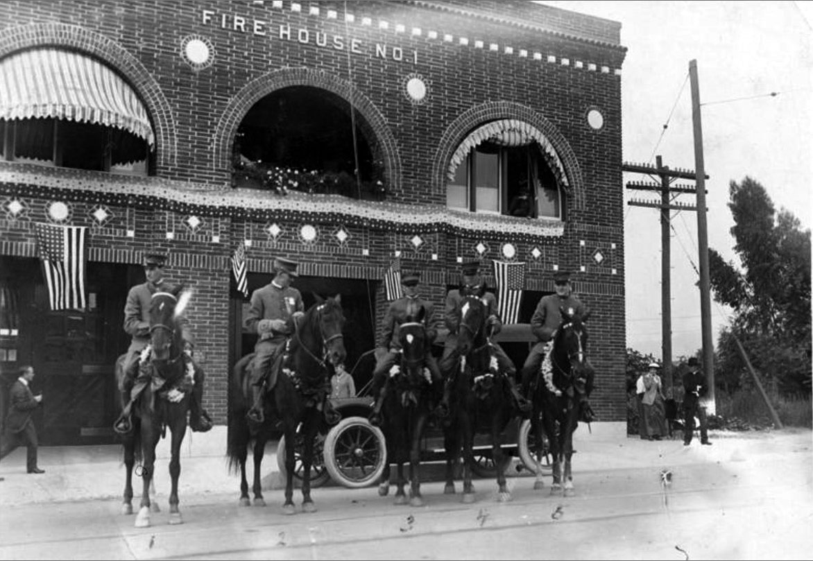
| (1916)***^ - View showing the police force of Glendale mounted on horseback in front of Fire House No. 1, located on Broadway between Louise and Kenwood Streets. (left to right) Emil Schroeder; Henry Hollenbeck; George Herald, Marshall & Fire Chief; Ernest Lawrence; Claire V. Arrington. |
Historical Notes From 1913 to 1918, the Glendale police and fire departments operated as a single entity out of Fire House No. 1 on Broadway between Louise and Kenwood Streets. Police officers and firemen were often required to perform double-duty when needed. In the upper right window are the twin sons of George Herald: Frank and George, Jr.***^ Click HERE to see more Early Views of the Glendale Police Department (1919 +) |
 |
|
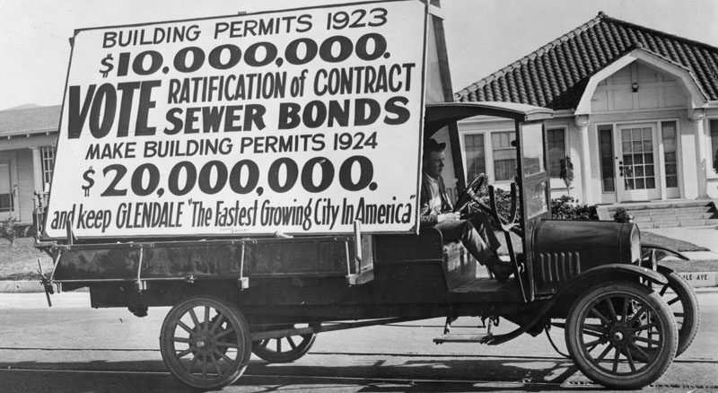
| (1923)^ - Glendale, incorporated as a city in 1906, by 1910 had a population of 2,742. In 1920 it had increased by 39%, to 13,576, creating "the fastest growing city in America." Here a truck bears a sign urging ratification of sewer bonds to enhance the awarding of building permits. |
 |
|
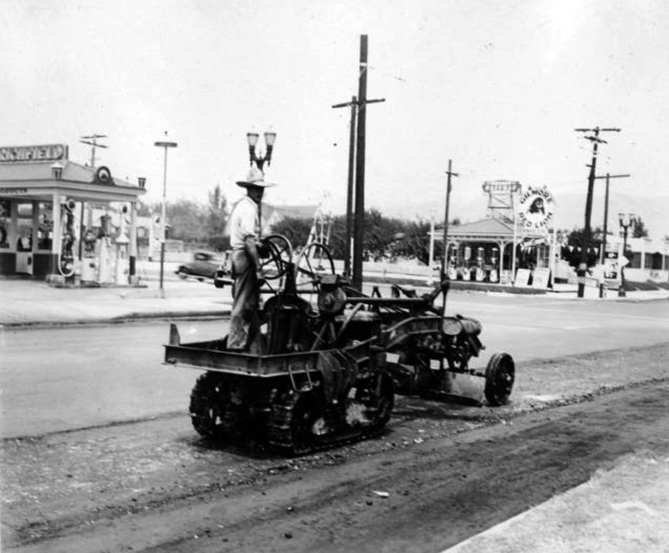
| (ca. 1930)***^ – View showing street paving in Glendale. A Richfield gas station and a Gilmore Red Lion gas station are visible in the background. |
 |
|
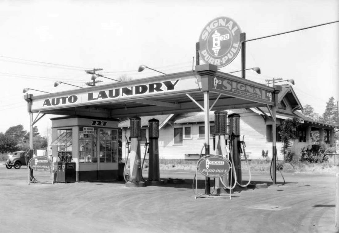
| (1931)^^ – Close-up view showing a 4-pump Signal Service Station in Glendale. Large signs reads Auto Laundry – Signal Purr-Pull. Click HERE to see more Early Views of Gas Stations. |
* * * * * |
Glendale Avenue
 |
|
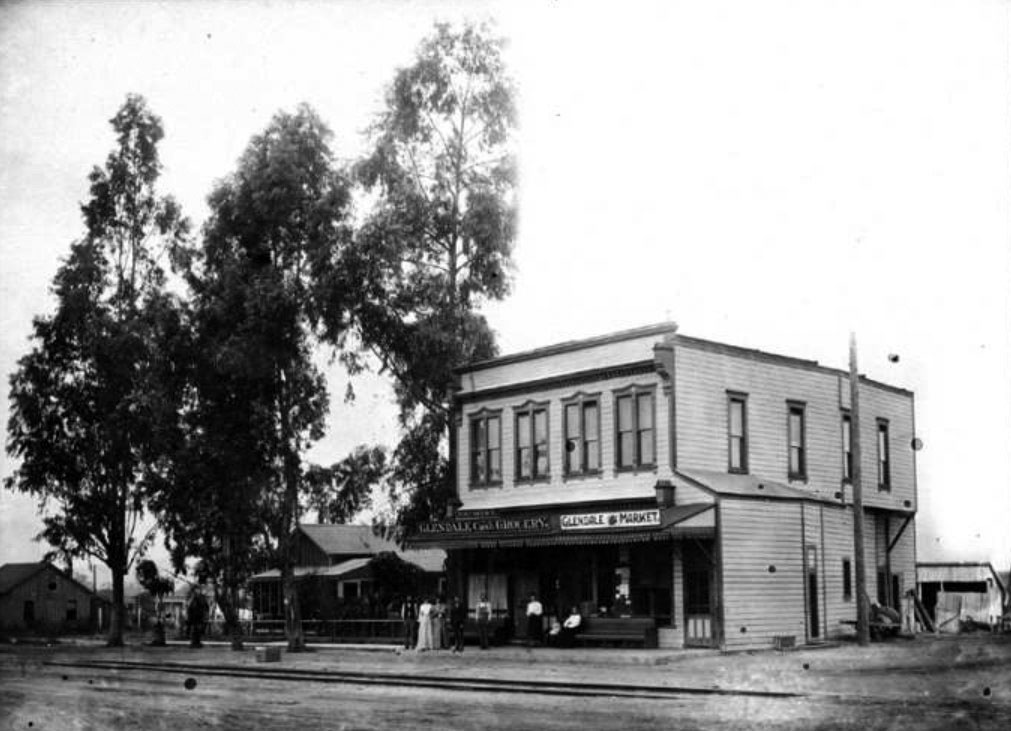
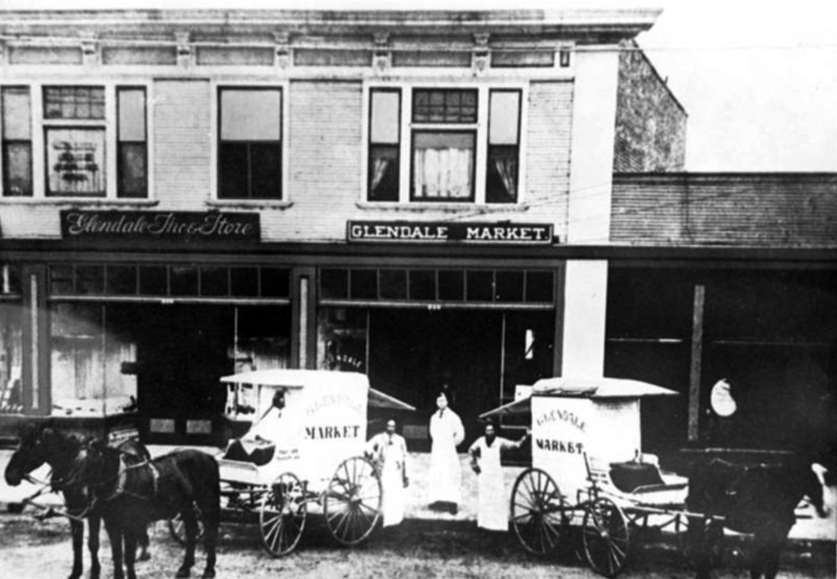
| (1895)***^ - View of the Glendale Market and the Glendale Cash Grocery Store on the southwest corner of Crow Avenue (now Glendale Avenue) and 3rd Street (now Wilson Avenue) in Glendale. The lean-to at the right corner was the local barbershop. Visible in the foreground are the train tracks that ran through the center of town connecting Glendale with downtown Los Angeles. |
 |
|
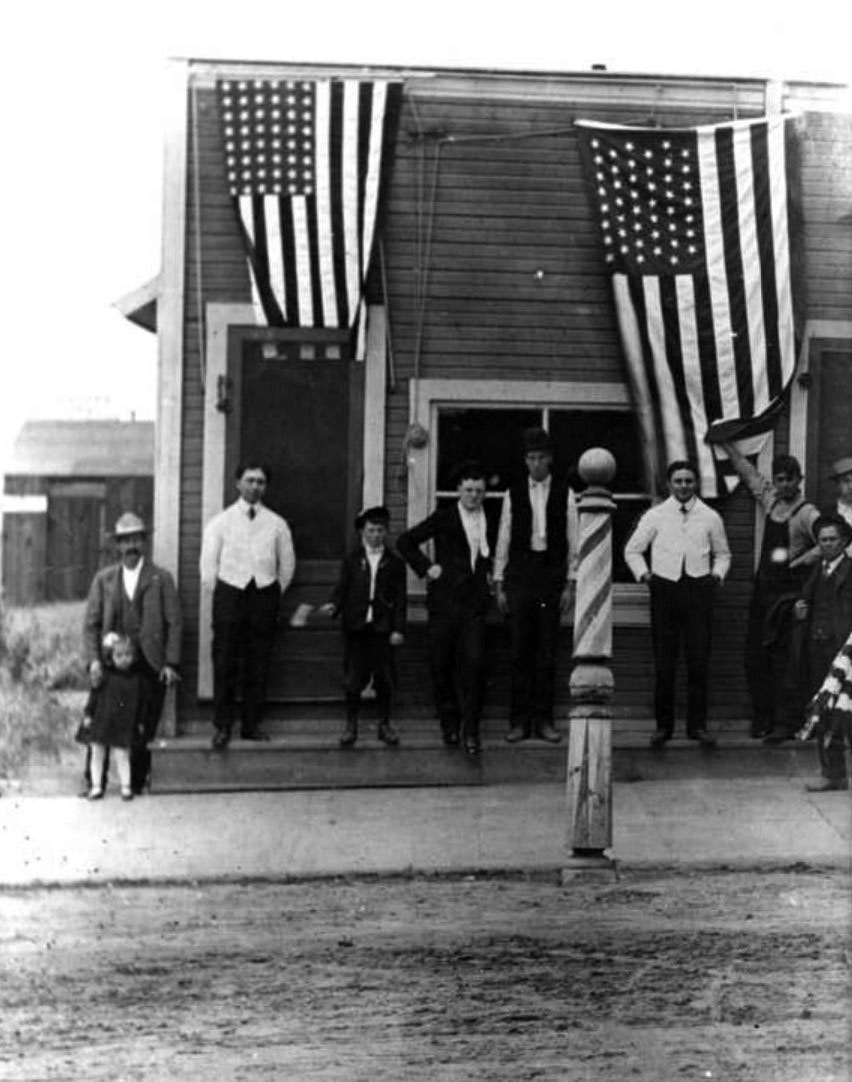
| (ca. 1900)##^ – A group of people pose in front of Al Oliver’s Barbershop located on the southwest corner of Everett Street and Wilson Avenue in Glendale. |
 |
|
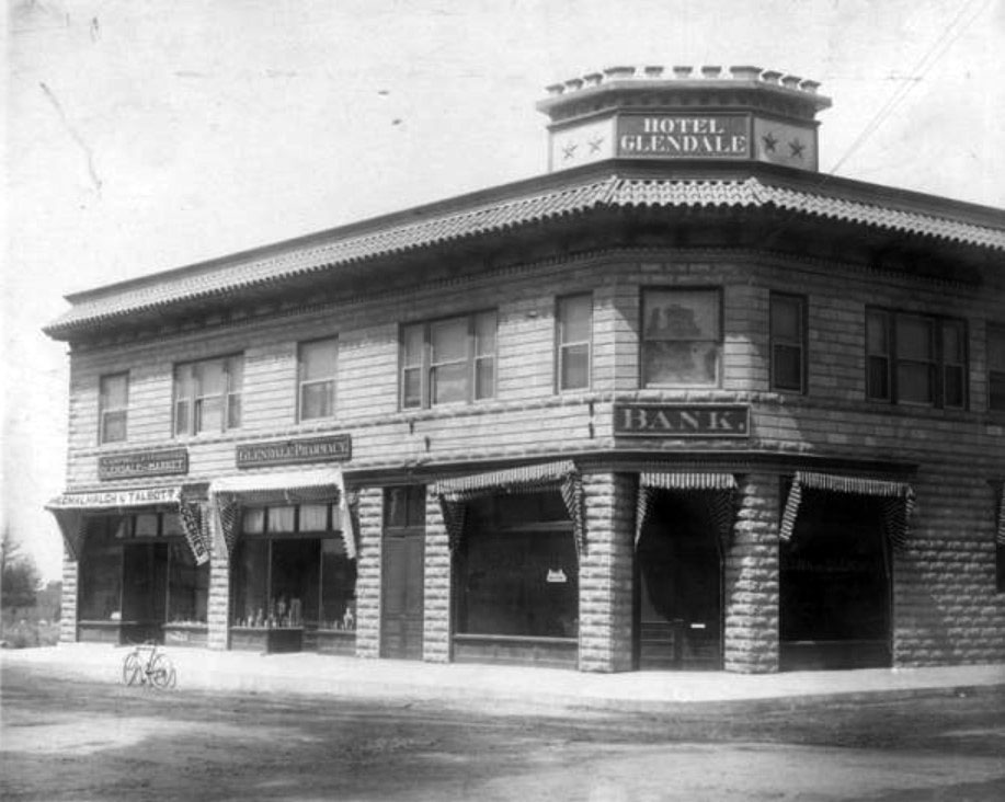
| (1905)***^ – View showing the Hotel Glendale located on the northwest corner of Glendale and Wilson Avenues (then Crow Avenue and 3rd Street). Glendale Bank occupies the ground floor. |
Historical Notes The Glendale Bank was the first bank in Glendale. The building was constructed by Mr. Ayers.***^ |
 |
|
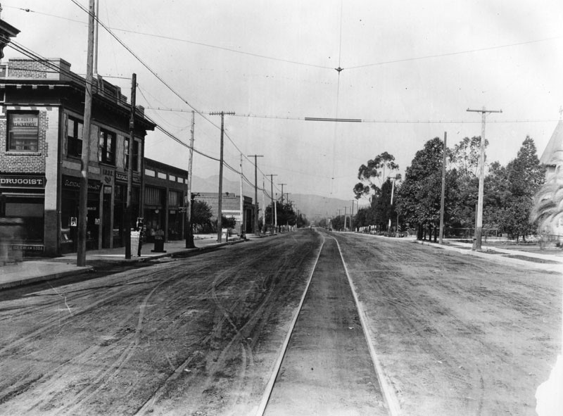
| (ca. 1908)***^ - Glendale Avenue, north from Harvard Street, circa 1908. The Southern Pacific railroad lines run down the center of Glendale Avenue. |
 |
|
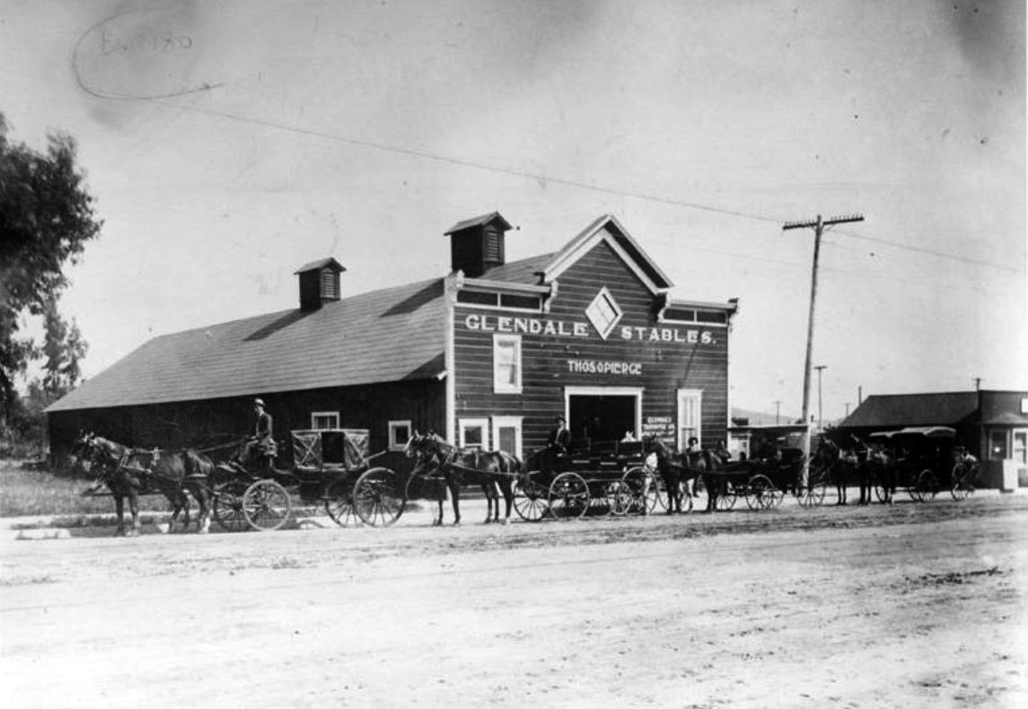
| (1909)***^ – Horse-drawn carriages are lined up in front of the Glendale Stables, located on Glendale Avenue. The stable was owned and operated by Thomas O. Pierce. |
 |
|
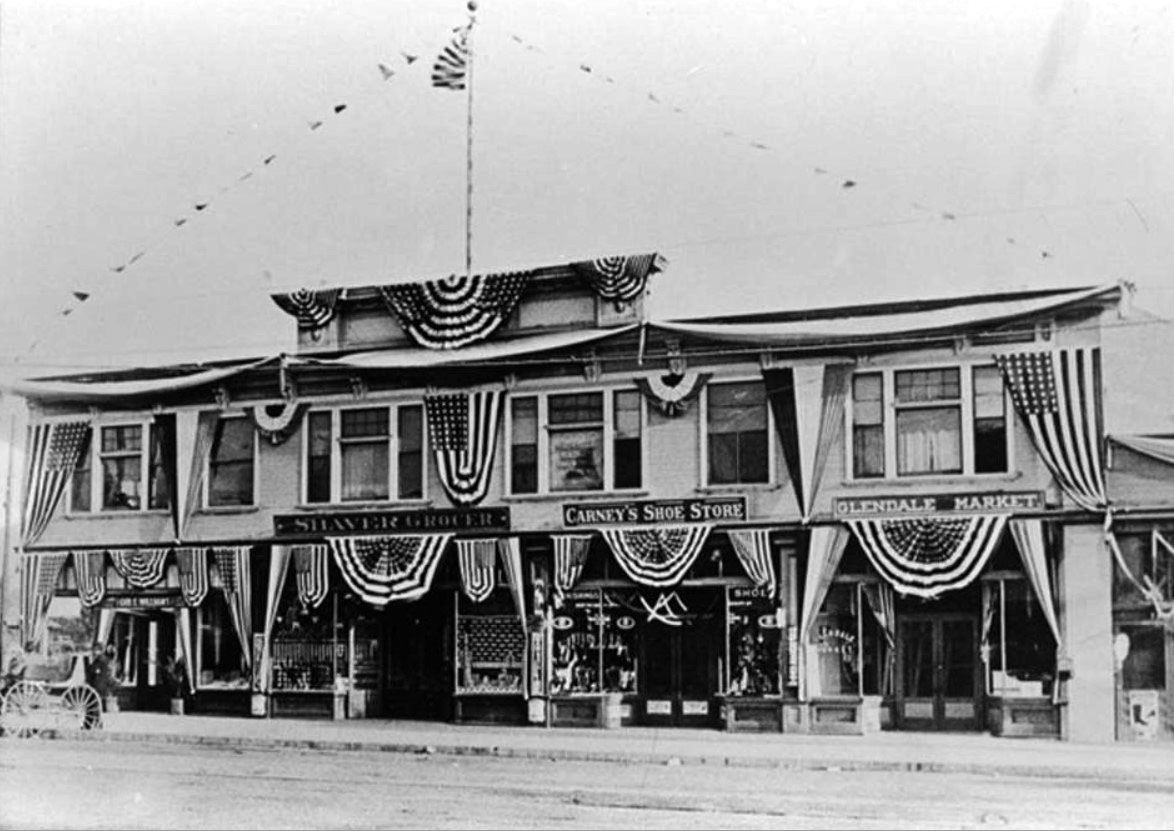
| (1911)##^ - View of the south side of East Broadway. Before the renaming and renumbering that occurred in 1916, this was the 500 block of West 4th Street. Visible here are: Shaver's Grocery Street, at 532 W. 4th Street, managed by H. G. McBain; Carney's Shoe Store, at 536 W. 4th Street, owned by Dave Carney; and Glendale Market, at 540 W. 4th Street, owned by C. W. Ingledue. |
 |
|
| (1910)***^ - The Glendale Market located on the southwest corner of Glendale Avenue and Broadway. Visible are (left to right): Fred Fish, Bill Whaley and unknown. |
 |
|
| (1910)^ - View of East Broadway in Glendale, looking west from Glendale Avenue. Street railway track and power lines are seen. |
Glendale and Broadway (S/E Corner)
 |
|
| (ca. 1910s)***^ – Postcard view showing The Bank of Glendale. The bank was originally located on the corner of Crow Avenue (now Glendale Avenue) and Broadway. |
 |
|
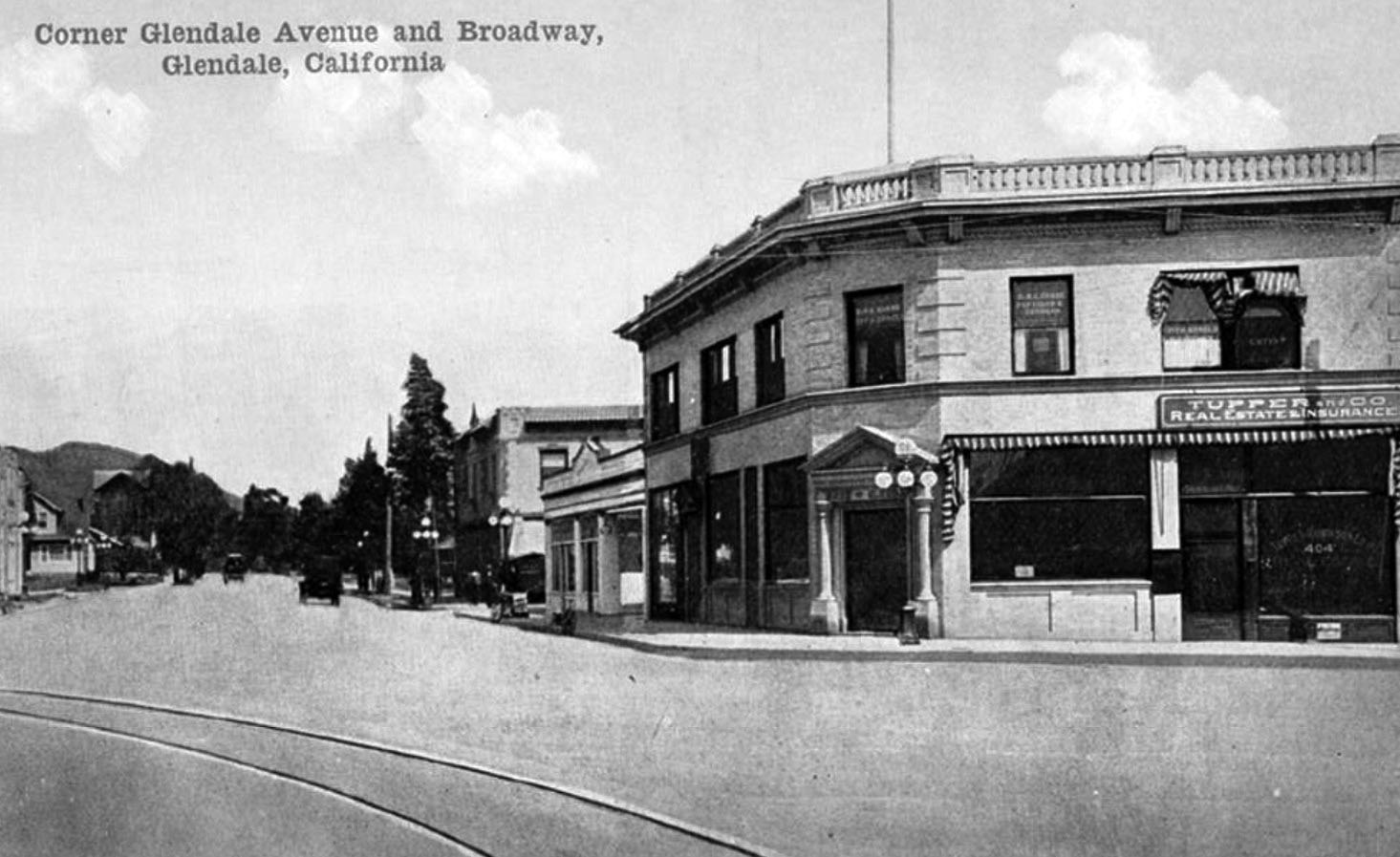
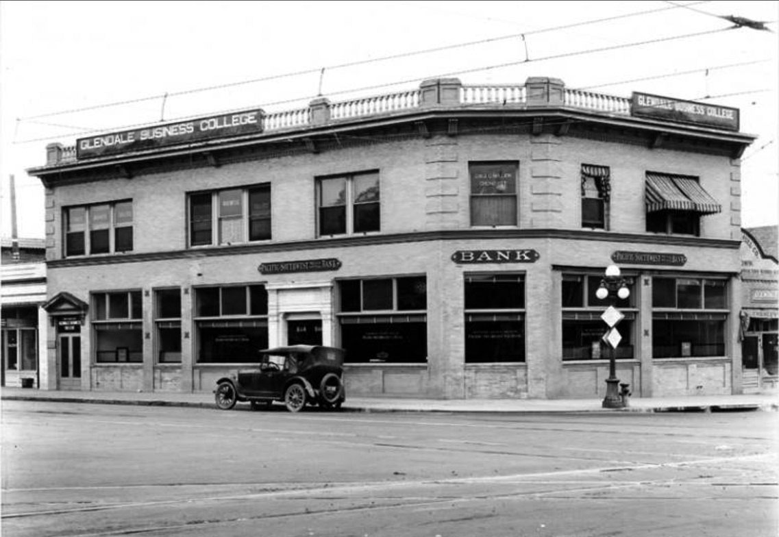
| (1922)***^ – View showing the Pacific Southwest Trust and Savings Bank and the Glendale Business College, located on the southeast corner of Broadway and Crow Avenue (now Glendale Avenue). |
Historical Notes From 1909 to circa 1922, the Glendale Bank was located in this building. The wires and tracks of the Pacific Electric Railway are visible running down the middle of the street. The Pacific Electric local line ran along East Broadway from Brand Boulevard to Chevy Chase Drive.***^ |
 |
|
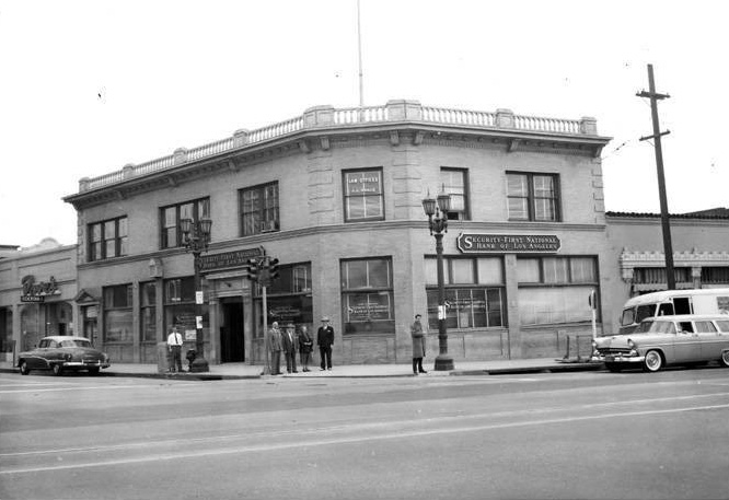
| (1955)^.^ – View showing the Security First National Bank of Los Angeles located on the corner of Glendale Avenue and Broadway. |
Historical Notes This building was lost to the 1971 Sylmar Earthquake. |
 |
|
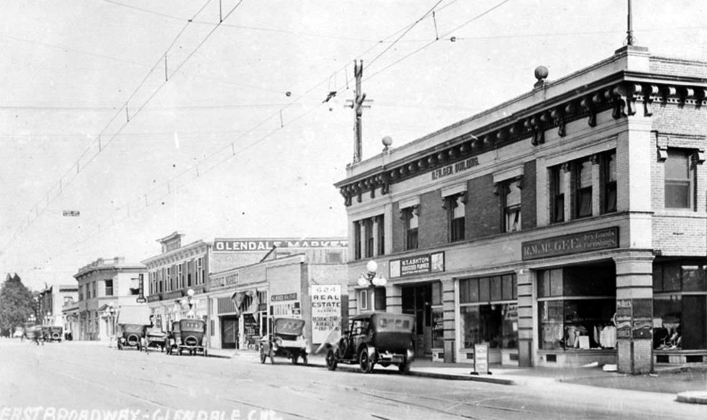
| (1921)##^ – View showing cars and businesses, including the D. Filger Building and the Glendale Market, along East Broadway in Glendale. The wires and tracks of the Pacific Electric Railway are visible running down the middle of the street. The Pacific Electric local line ran along East Broadway from Brand Boulevard to Chevy Chase Drive. In the distance can be seen the Pacific Southwest Trust and Savings Bank building on the SE corner of Glendale and Broadway. |
 |
|
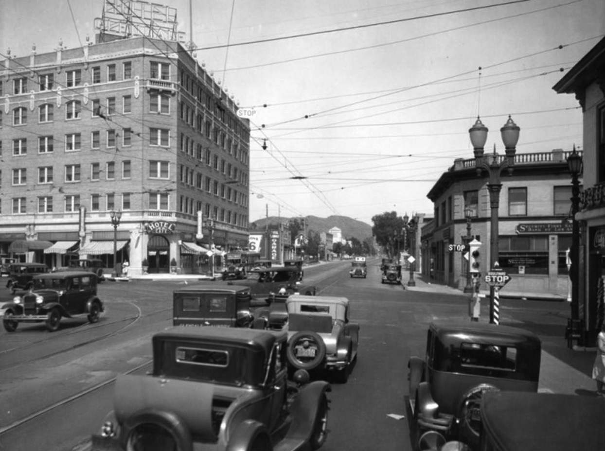
| (ca. 1928)* – View showing the intersection of Broadway and Glendale Avenue, looking east. On the southeast corner is a branch of Security-First National Bank of Los Angeles. On the northeast is a hotel and cafe. A semaphore traffic signal is seen on the corner (center-right). A car with a rumble seat can be seen in the foreground. |
* * * * * |
Terminal Market
 |
|
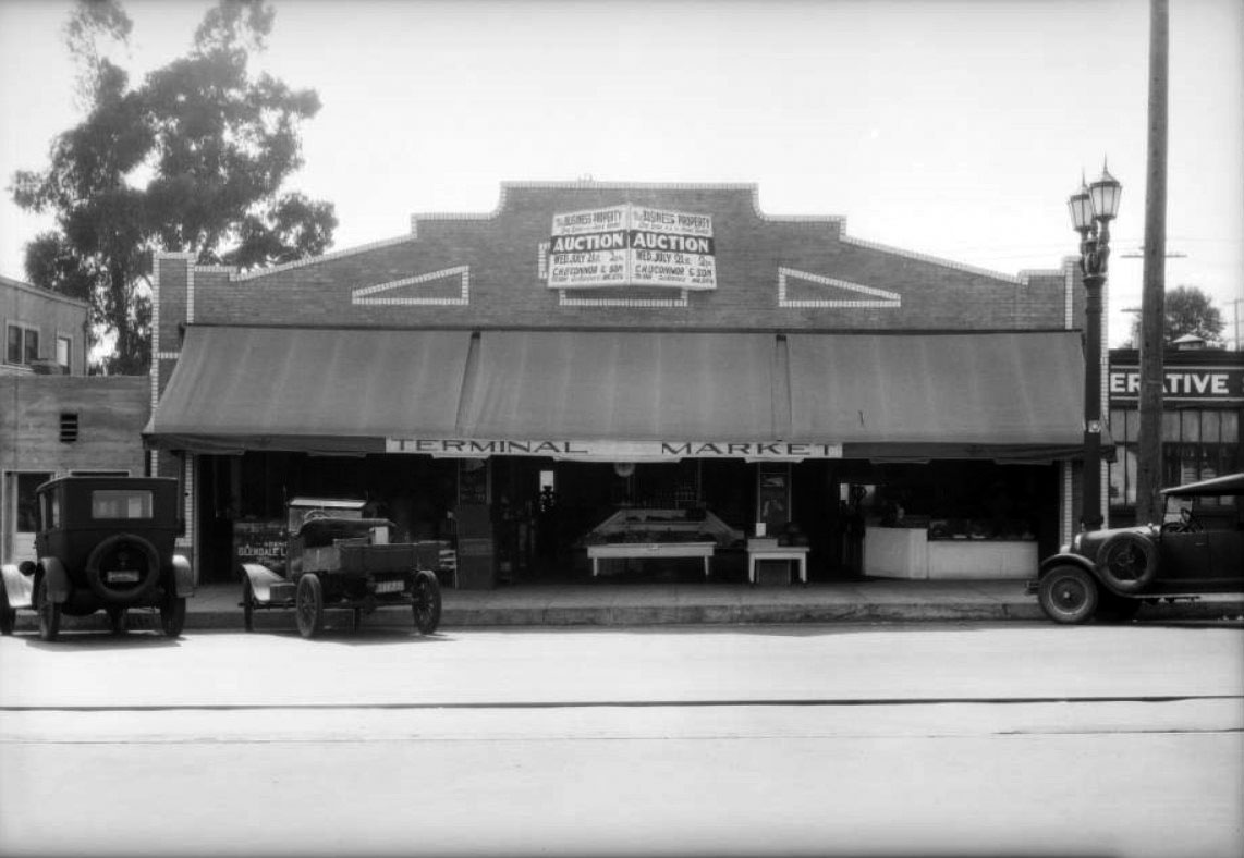
| (1926)^^ - View showing cars parked in front of Terminal Market at 123 North Glendale Avenue, Glendale. |
Tropico and Glendale
 |
|
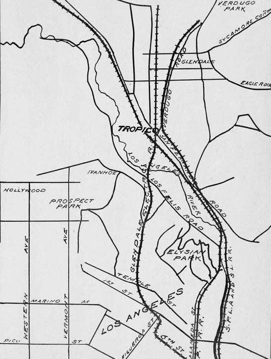
| (1903)^ – A map of Tropico showing rail lines and surrounding area. |
Historical Notes Tropico was put on the map as a fertile agricultural spot in the late 1800s. Shortly thereafter, the town began distancing itself from the rest of Glendale. In 1918, the neighborhood formally succeeded in becoming an independent entity for a short time. |
 |
|
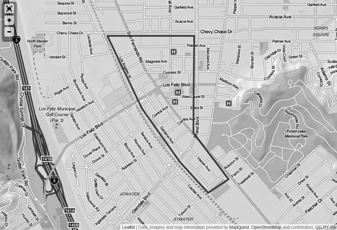
| (n.d.)*^ – Map view showing the boundaries of Tropico. |
Historical Notes Tropico was the name of the southern portion of Glendale, south of Windsor Road, between the late 1800s and 1918. The name "Glendale" had originated in the 1880s and was utilized north of Windsor Road. Political factions had divided the town in two. By the turn of the century, the commercial center of Tropico was at Central and San Fernando Road and its population was 700.* |
 |
|
| (1910)^ - View of Tropico looking southwest to the Pacific, from the lower slopes of what would become Forest Lawn Memorial Park, Glendale. Photo by Edward Weston. |
 |
|
| (1910)^ - View of Tropico looking southwest to the Pacific, from the lower slopes of what would become Forest Lawn Memorial Park, Glendale. Annotated by Paul Ayers |
 |
|
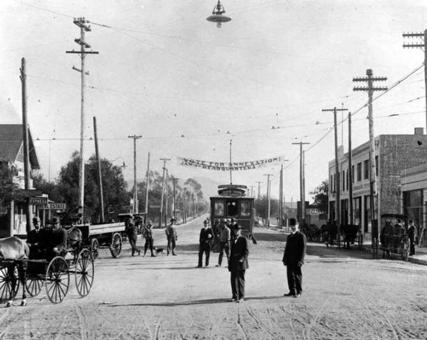
| (1911)^ – A banner in support of the annexation of Tropico to Glendale in 1911 hangs outside the measure's headquarters on Broadway near Brand Boulevard in Glendale. The measure failed to pass, with Tropico instead voting for its own incorporation as a city. The issue would be revisited in 1918, when the upper half of Tropico would become a part of Glendale. |
Historical Notes Tropico was just a sleepy little village in the early 1900s. The business district included a few wooden buildings containing a general store, a blacksmith shop, meat store, livery stable, real estate offices and a few other small concerns. The buildings were all clustered near the intersection of San Fernando Road and Central Avenue. But within a few short years, the wood-frame buildings were replaced with brick, business boomed and the community became vibrant. The Tropico Art Tile Works stood just west of the railroad tracks, employing many people, and Tropico also became the shipping center for the strawberries raised in the area. Because of its proximity to Los Angeles, the area became a popular residential spot. The Tropico Chamber of Commerce organized in 1910, along with the Bank of Tropico, and soon the community realized it needed a city government. With so many of its residents commuting into Los Angeles, many favored annexing to Los Angeles. Others, seeing Glendale's successful example of home rule, wanted to be part of Glendale, which had incorporated in 1906.^ |
 |
|
| (1910s)^ - View looking N/W on San Fernando Road at Central Ave with the Bank of Tropico located on the triangular lot at right. |
Historical Notes With so many of its residents commuting into Los Angeles, many favored annexing to Los Angeles. Others, seeing Glendale's successful example of home rule, wanted to be part of Glendale, which had incorporated in 1906. They felt that since the two communities were adjacent and in the same valley, they should be affiliated. Those favoring annexation with Glendale (mainly in the northeast part of Tropico) approached Glendale officials in 1911 and asked that an election be called. The publishers of the Tropico Sentinel vehemently opposed annexation, and the issue failed. Instead, Tropico incorporated as its own city, with Elkanah W. Richardson, son of Tropico's founder, W.C.B. Richardson, serving as a member of the board of trustees. The new city government immediately embarked on a badly needed improvement of the roads, but the annexation issue didn't go away. Petition after petition was filed, each one eventually failing, until finally, in 1918, the annexation proposal passed. The upper half of Tropico voted to go with Glendale, and the lower half voted to merge with Los Angeles. Today, that portion makes up the area known as Atwater.^ |
 |
|
| (1915)^ - View looking N/W on San Fernando Road at Central Ave, Tropico. |
 |
|
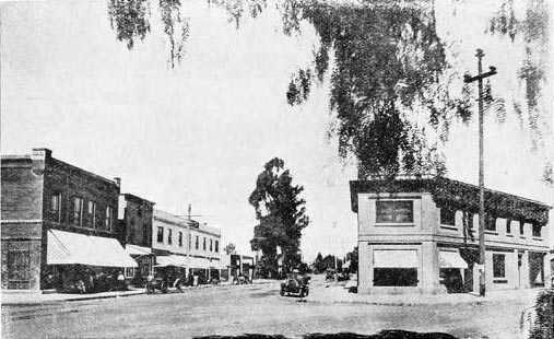
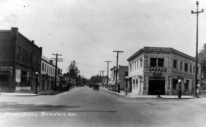
| (1920s)^*# - View looking N/W on San Fernando Road at Central Ave after Tropico was annexed into the city of Glendale This is the same intersection as previous photo but about 10 years later. The building housing the Bank of Tropico is now Hotel de Lux and a Garage. Note the gas pumps along the curb. Click HERE for contemporary view. |
 |
|
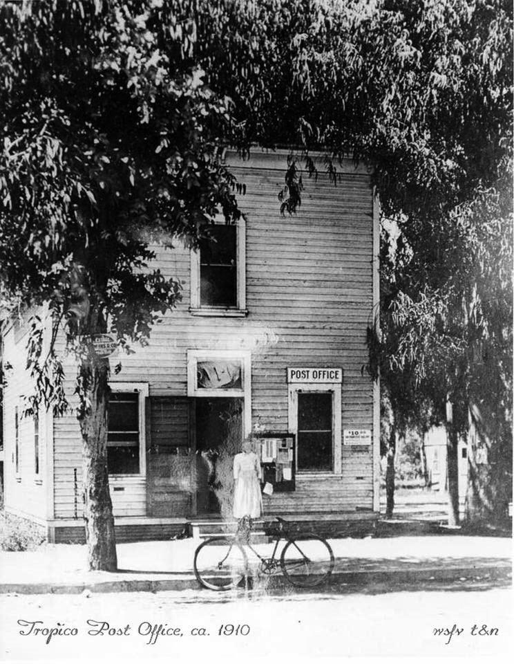
| (ca. 1910)^ – View showing a woman standing in front of the Tropico Post Office, with a bicycle parked by the curb. |
Historical Notes The Tropico Post Office building was owned by WCB Richardson and was located near the corner of Central Avenue and San Fernando Road. |
 |
|
| (1915)* – Studio of famous photographer Edward Weston, located in Tropico. |
Historical Notes Edward Henry Weston has been called "one of the most innovative and influential American photographers..." and "one of the masters of 20th century photography." Over the course of his 40-year career Weston photographed an increasingly expansive set of subjects, including landscapes, still-lifes, nudes, portraits, genre scenes and even whimsical parodies. It is said that he developed a "quintessentially American, and especially Californian, approach to modern photography" because of his focus on the people and places of the American West. In 1937 Weston was the first photographer to receive a Guggenheim Fellowship. In 1910 Weston opened his own business, called "The Little Studio", in Tropico. His sister later asked him why he opened his studio in Tropico rather than in the nearby metropolis of Los Angeles, and he replied "Sis, I'm going to make my name so famous that it won't matter where I live."* Weston photographed many of the early buildings and local events in Glendale. |
Then and Now
|
|
 |
|
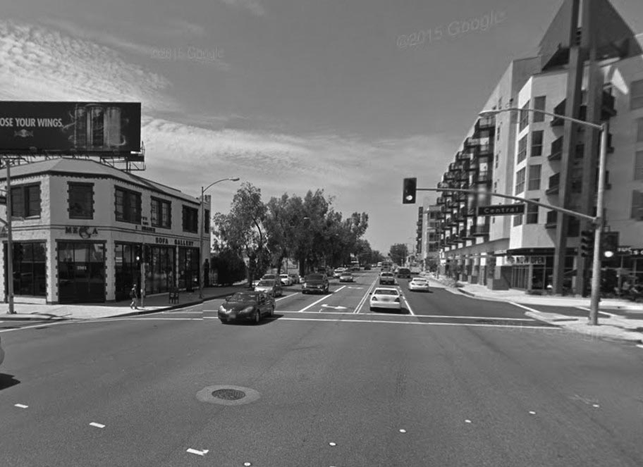
| (1910s vs. 2015)* – View looking N/W on San Fernando Road at S. Central Avenue. |
Then and Now
 |
|
| (1910s vs 2022)* - Looking N/W on San Fernando Road at S. Central Ave. |
 |
|
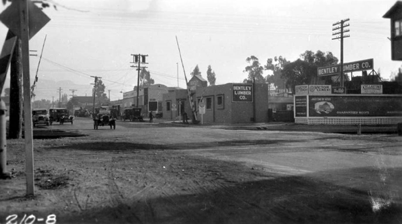
| (ca. 1921)^ - Southern Pacific Railway grade crossing in the Tropico area of Glendale. The city of Tropico was annexed by Glendale in 1918. Bentley Lumber Company is visible on the right. |
* * * * * |
Broadway Elementary School (today John Marshall Elementary School)
 |
|
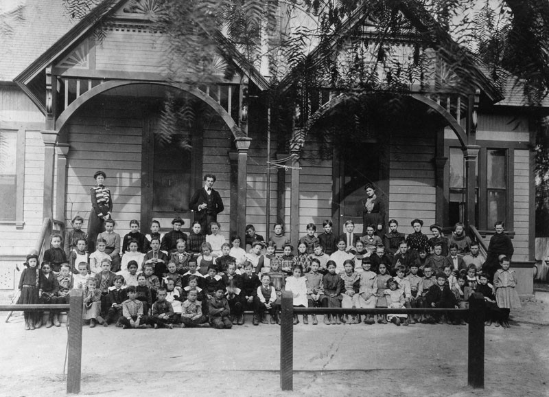
| (1902)^ - Group portrait of children and adults in front of the Broadway Elementary School located at Broadway and Chevy Chase since 1887. John Marshall Elementary School stands at this site today. |
 |
|
| (n.d.)^ - Picture postcard of the exterior view of Broadway School, which has been located on the same site at Broadway and Chevy Chase since 1887. The school has undergone five different name changes, the current being John Marshall Elementary School, in memory of U.S. Supreme Court Justice John Marshall, and the present-day address is 1201 East Broadway. |
 |
|
| (n.d.)^ - View showing the main entrance of Broadway School, located at Broadway and Chevy Chase in Glendale since 1887. For several years the main building had picturesque two-story pillars in front, resembling the White House. The pillars were demolished when the east and west wings were rebuilt in 1950. |
Glendale Police Department
 |
|
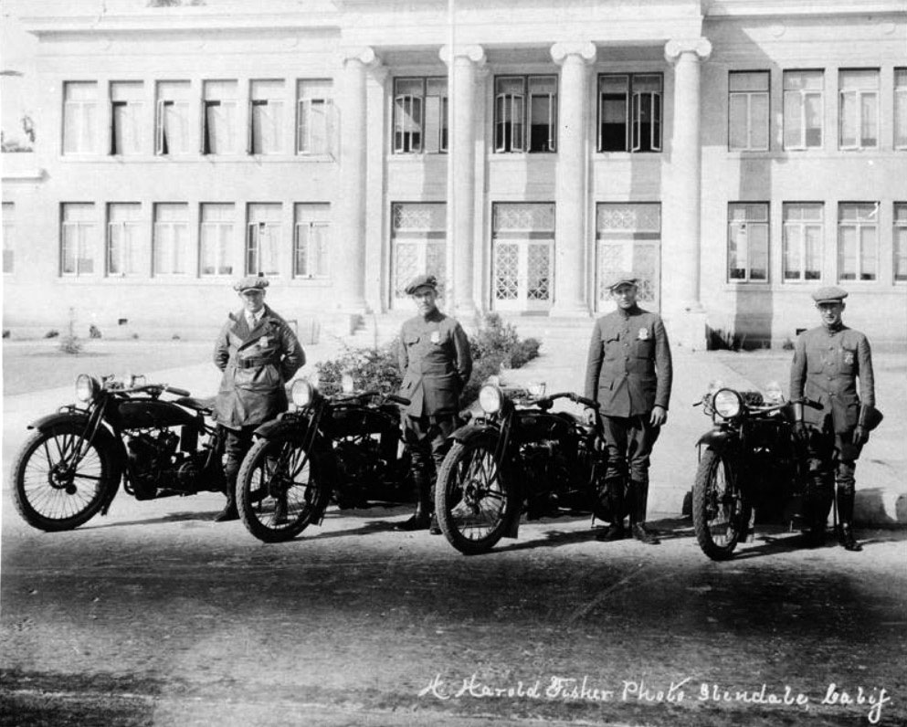
| (ca. 1919)* - Glendale Police Department Motor Division. Several members of the Glendale Police Department pose with their Indian motorcycles in front of Broadway Elementary School. |
 |
|
| (1920s)* - A man named Wykoff receives a traffic ticket from a member of the Glendale Police Dept. The photo shows a close-up of the policeman's Harley-Davidson motorcycle. |
 |
|
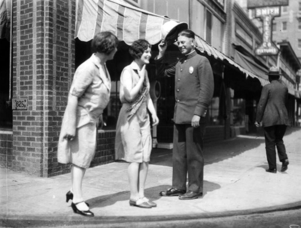
| (ca. 1920s)* - A member of the Glendale Police Dept. tips his hat to two women on Broadway, in front of Smith Electric Co. |
Historical Notes Click HERE to see more Early Views of the Glendale Police Department (1938 +). |
 |
|
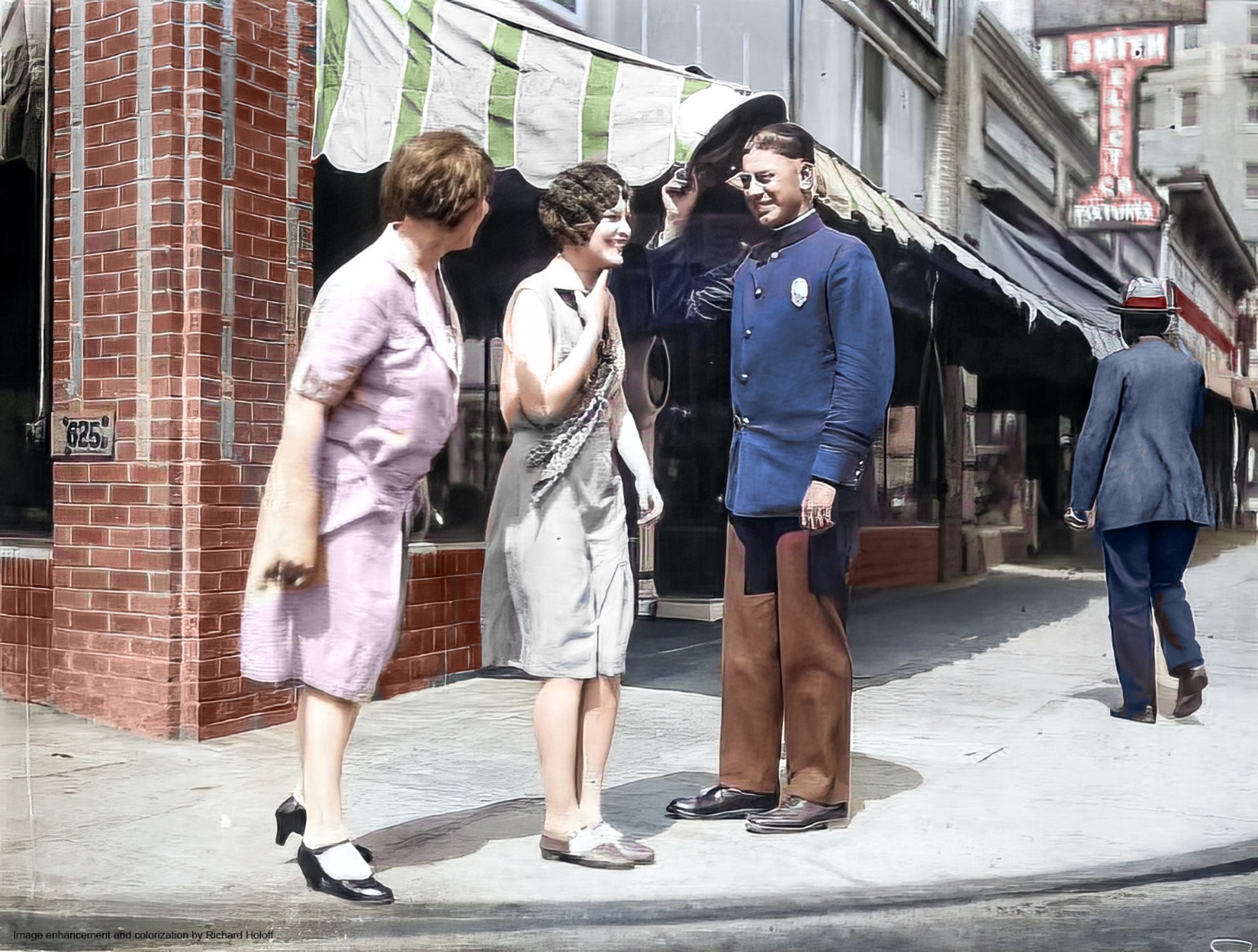
| (ca. 1920s)* - A member of the Glendale Police Dept. tips his hat to two women on Broadway, in front of Smith Electric Co. Image enhancement and colorization by Richard Holoff |
Historical Notes Click HERE to see more Early Views of the Glendale Police Department (1938 +). |
Glendale City Hall
 |
|
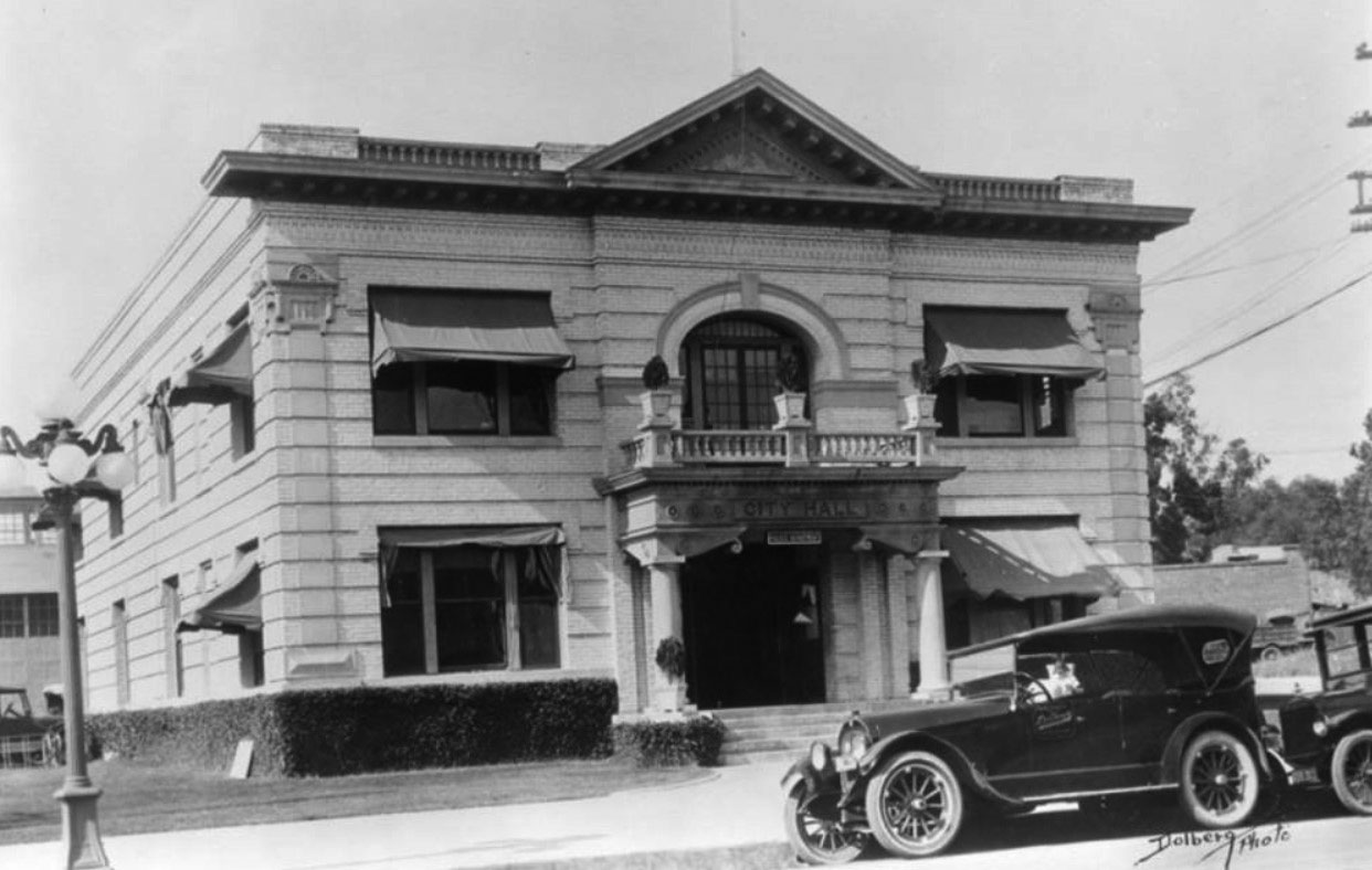
| (1920s)^ - Exterior view of Glendale's City Hall building which also houses its Police Department. Two large pillars stand on each side of the entrance. Note architecture at top and corners of this all brick building. |
Chevy Chase Drive
 |
|
| (ca. 1915)^.^ – View showing Sycamore Canyon Road before it became Chevy Chase Drive. |
Historical Notes The name Chevy Chase actually comes from an ancient Scottish ballad called "The Ballad of Chevy Chase". The "chase" refers to a hunting party, and the "Chevy" is from the Cheviot Hills, which are located along the English/Scottish border. Some parts of Chevy Chase Drive were originally named Park Avenue and Sycamore Canyon, but in the mid 1920's a real estate agent named E.R. Austin worked to create an additional entrance into Glendale from Los Angeles and was able to convince L.A. and Glendale officials to change the name of this route to Chevy Chase Drive for the entire length of the street, as well as extend the street in various places. All this combining of names and extending made Chevy Chase Drive the longest street in Glendale.^ |
East Broadway
 |
|
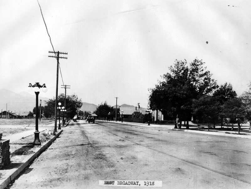
| (1918)^ - View of E. Broadway looking west at Orange in Glendale. This is near where the Glendale Galleria is today. Note the ornate streetlights. Click HERE to see map. |
 |
|
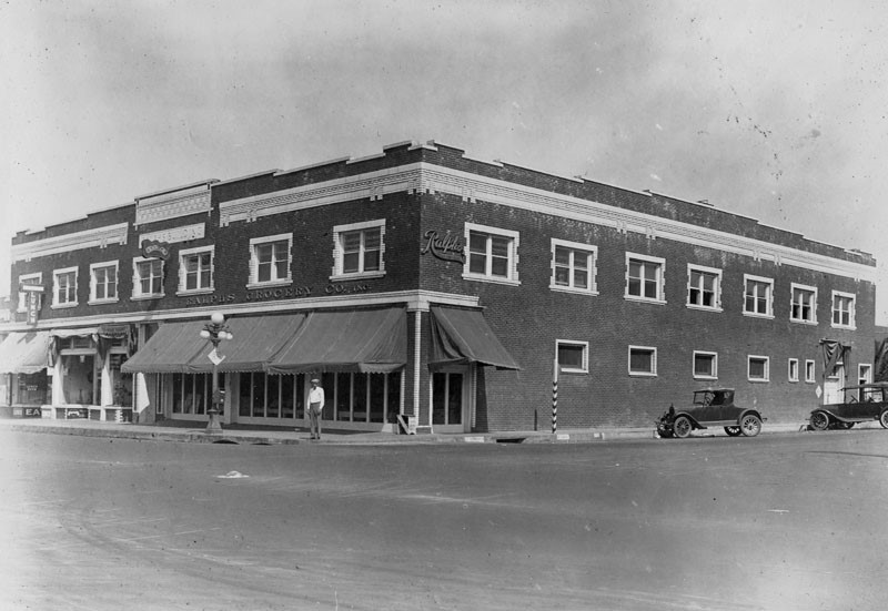
| (ca. 1920)^ – A man stands on the corner of Orange and Broadway in front of the Ralphs grocery store. |
Aurora Market
 |
|
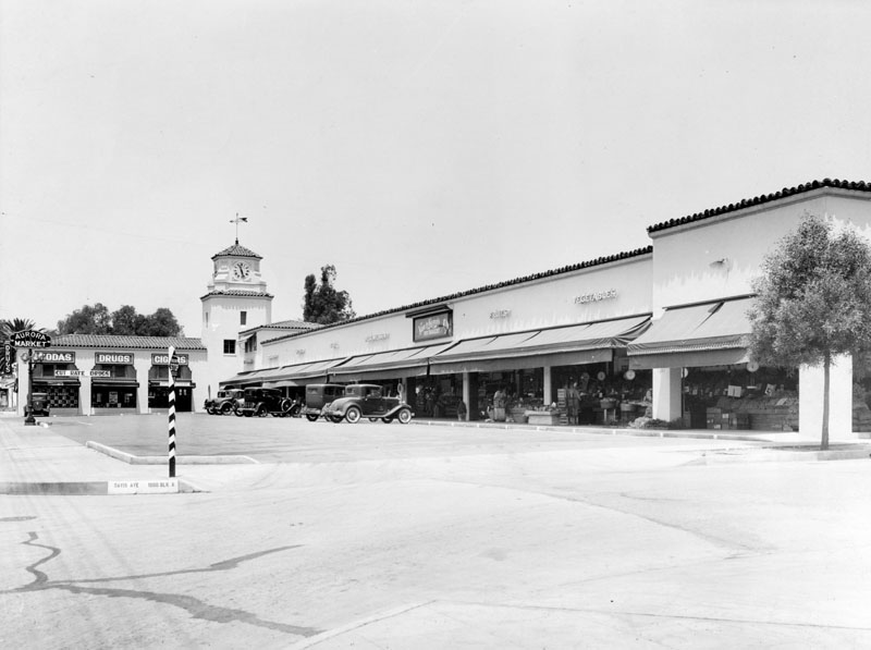
| (1920s)^ - View of Aurora Market located in a plaza at the corner of Davis Avenue, in Glendale. Note the clock tower in the corner of the 'L' shaped drive-in market. |
Historical Notes Southern California was the principal center for the development of drive-in markets between the mid-1910s to the early 1940s. Other notable early drive-in markets included: Mandarin Market (Hollywood), Plaza Market (LA), and the Sunset Clock Market (Beverly Hills). |
 |
|
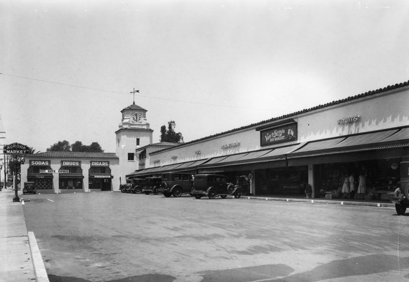
| (1920s)^ - Close-up view showing drive-in Aurora Market with a Van de Kamp's Bakery seen on the right next to a florist. |
Los Feliz and San Fernando
 |
|
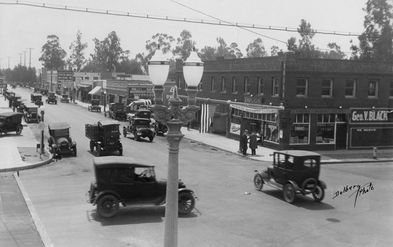
| (ca. 1920)^ - Looking south at an intersection of Los Feliz Blvd. and San Fernando Rd. Various cars and trucks are traveling on the street. There are businesses on right side of the street some include: "Geo. V. Black prescription Druggist" and "Baker's Hardware". Note the ornate dual-lamp streetlight. Click HERE to see more Early Streetlights. |
Historical Notes Los Feliz Boulevard in Glendale was formerly called Tropico Boulevard. ^ |
 |
|
| (ca. 1920s)^ - A view of San Fernando Rd. looking north at an intersection of Los Feliz Blvd. Various cars and trucks have stopped at the intersection. There are businesses that run along both sides of the street some include: a drug store, a sports equipment store, the "Piggly Wiggly", "Tavern Buffet", "Glenwood Hotel" and a service station with gasoline pumps. |
* * * * * |
Glendale Union High School |
As Glendale evolved from a quiet farming community into one of Southern California's fastest growing cities, its schools expanded just as rapidly. In 1901, residents of Glendale, La Crescenta, Burbank, Eagle Rock, Ivanhoe (now Silver Lake), Tropico, and West Glendale joined together to establish Glendale Union High School, giving local students the opportunity to attend high school without traveling to Los Angeles. During its first quarter century, the school occupied four homes as enrollment grew from just 29 students to more than 1,000. Beginning in the dining room of the Glendale Hotel, it moved to the little yellow "Cheesebox," then to an impressive brick campus on Harvard Street, before finally settling at its present location on East Broadway. The school's history mirrors Glendale's remarkable transformation from a rural village into a thriving city. The photographs in this section trace those formative years while also capturing everyday student life, from the library reading room to the football field. Among the players in the 1924 team photograph is senior class president Marion Morrison, better known to his classmates as "Duke." The world would later know him as John Wayne. |
 |
|
| (1902)^* – View showing Glendale Union High School's first permanent building, affectionately known as "The Cheesebox" because of its bright yellow paint. It stood on the southeast corner of Brand Boulevard and Broadway, opposite the present site of the Glendale Security Building. |
Historical Notes Glendale Union High School opened in September 1901 in the dining room of the vacant Glendale Hotel with principal Llewellyn Evans, two teachers, and 29 students. Until then, local schools ended at the eighth grade, requiring students seeking a high school education to travel into Los Angeles. The following year, a permanent school was built at Brand Boulevard and Broadway. Completed in late 1902, the bright yellow two story frame building quickly earned the nickname "The Cheesebox." George U. Moyse became principal that same year and would guide the school through 35 years of remarkable growth. By 1907, enrollment had more than tripled, and the little schoolhouse was already too small for Glendale's rapidly growing population. |
 |
|
| (ca. 1909)* – View showing Glendale Union High School at its third home, on Harvard Street, where the Glendale Central Library stands today. |
Historical Notes Rapid enrollment soon outgrew the Cheesebox. Construction began in 1908 on a new two story pressed brick high school on Harvard Street, and students occupied the building in September 1909. It was Glendale's first brick school, reflecting both the community's growing confidence and its commitment to public education. Three additional acres were acquired in 1913, allowing two more classroom buildings to be constructed as enrollment continued to climb. Even these improvements could not keep pace with Glendale's explosive population growth during the following decade. |
 |
|
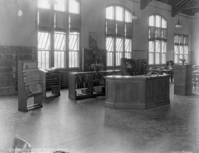
| (ca. 1920s)* - Interior view of the Glendale Union High School library. Bookshelves line the back wall, while newspaper racks, magazine shelves, study tables, and the information desk reflect the academic life of the growing school. |
Historical Notes By the early 1920s, Glendale Union High School had developed into a full academic institution with student government, language clubs, debating, and its weekly student newspaper, The Explosion. The library became the academic heart of the campus, providing students with books, newspapers, magazines, and reference materials at a time when Glendale itself was still a young and rapidly developing city. Like libraries everywhere before the digital age, it served as both a place for study and discovery, where generations of students developed the research skills that would prepare them for college, careers, and civic life. |
 |
|
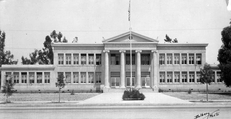
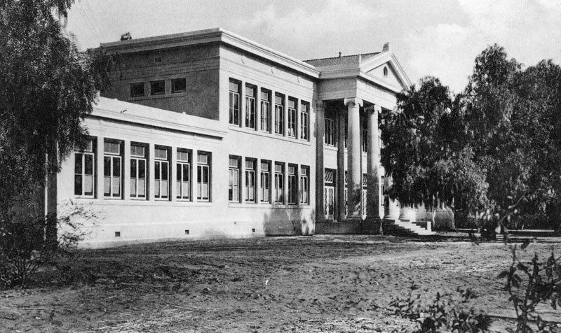
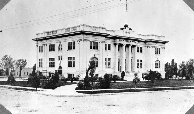
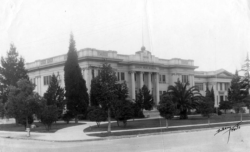
| (ca. 1920)* - View of Glendale Union High School on Harvard Street in Glendale. The school moved to its present campus at 1440 East Broadway in 1924. |
Historical Notes Enrollment reached approximately 800 students in 1920 and 1,050 the following year, stretching the Harvard Street campus beyond its capacity. Temporary classroom buildings were added, but it soon became clear that a much larger campus was needed. Voters approved bond measures to purchase a 21 acre lemon orchard at Broadway and Verdugo Road, where Glendale High School opened its new campus in 1924. The Harvard Street buildings remained in use for several years before becoming home to Glendale Junior College. Glendale High School has remained at 1440 East Broadway ever since. |
 |
|
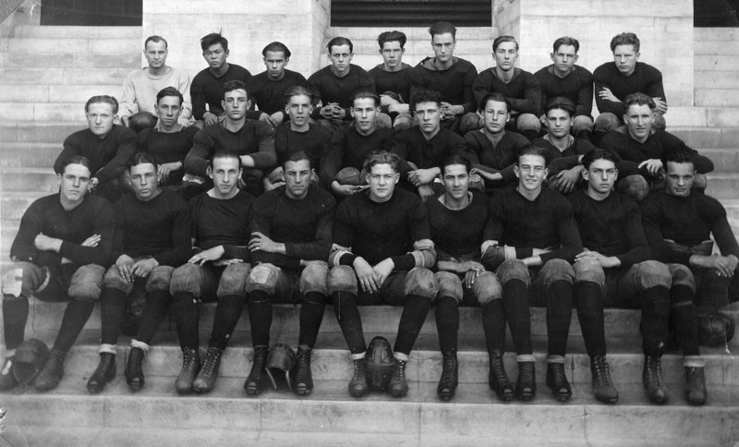
| (1923)* – Members of the Glendale Union High School football team pose on the steps of the school's new East Broadway campus. The soft leather helmets resting between several players' feet were standard equipment during an era when headgear was still optional. Seated in the front row, third from the right, is Marion Morrison, later known to the world as John Wayne. |
Historical Notes Football helmets during the 1920s were made of padded leather and offered only limited protection. Many players still chose to play without them, and helmets did not become mandatory in college football until 1939. Plastic helmets gradually replaced leather models after World War II. Seated in the front row, third from the right, is Marion Morrison, better known by his nickname "Duke." A standout football player, senior class president, and sports editor of The Explosion, Morrison graduated from Glendale Union High School in 1925 before attending USC on a football scholarship. After losing his scholarship, he entered the motion picture industry and eventually achieved worldwide fame under the screen name John Wayne, appearing in more than 170 films over five decades and becoming one of Hollywood's most recognizable and enduring stars. Today, known simply as Glendale High School, the institution has grown far beyond its beginnings as Glendale Union High School. From just 29 students meeting in a hotel dining room in 1901, it has evolved into one of Southern California's oldest public high schools. More than 120 years after its founding, Glendale High continues to educate new generations of students while preserving the rich legacy established during its formative years. |
* * * * * |
EL MIRADERO |
High on the lower slopes of the Verdugo Mountains stands one of Southern California's most distinctive historic homes. With its gleaming white domes, slender minarets, and graceful scalloped arches, El Miradero has overlooked Glendale for more than 120 years. Built in 1904 by developer and civic leader Leslie Coombs Brand, the mansion reflected both his success and his extraordinary vision for the community that was taking shape below.Designed by Brand's brother-in-law, architect Nathaniel Dryden, the mansion drew inspiration from the East Indian Pavilion at the 1893 World's Columbian Exposition in Chicago. Its exotic Saracenic design blended Spanish, Moorish, and Indian architectural influences, making it unlike any other residence in Southern California. Beyond its striking appearance, El Miradero became the center of Glendale's social life and a symbol of the city's growing prosperity.The estate would also play an unexpected role in Southern California's aviation history. Fascinated by the new world of flight, Brand built a private airfield below the mansion where pilots gathered for fly-in parties during aviation's earliest years. After Brand's death in 1925, his estate was given to the City of Glendale to serve forever as a public park and library. Today, El Miradero lives on as the Brand Library & Art Center, preserving not only an architectural masterpiece but also the remarkable legacy of the man whose vision helped shape the Glendale we know today. More than a century after its construction, El Miradero remains one of Glendale's most cherished landmarks, reflecting the vision, generosity, and enduring legacy of Leslie C. Brand. |
Building a Landmark
 |
|
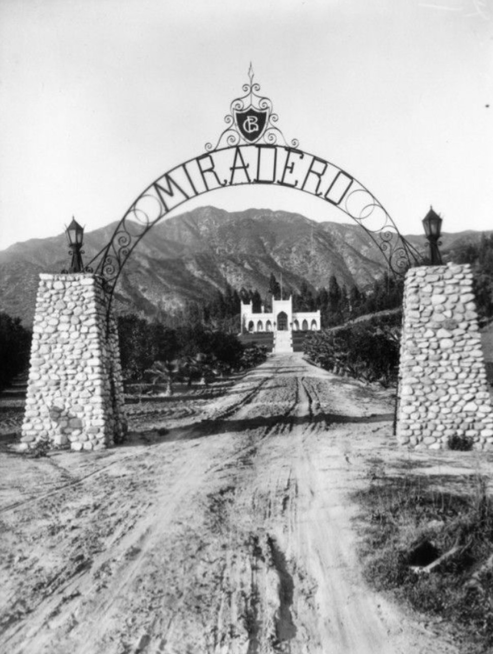
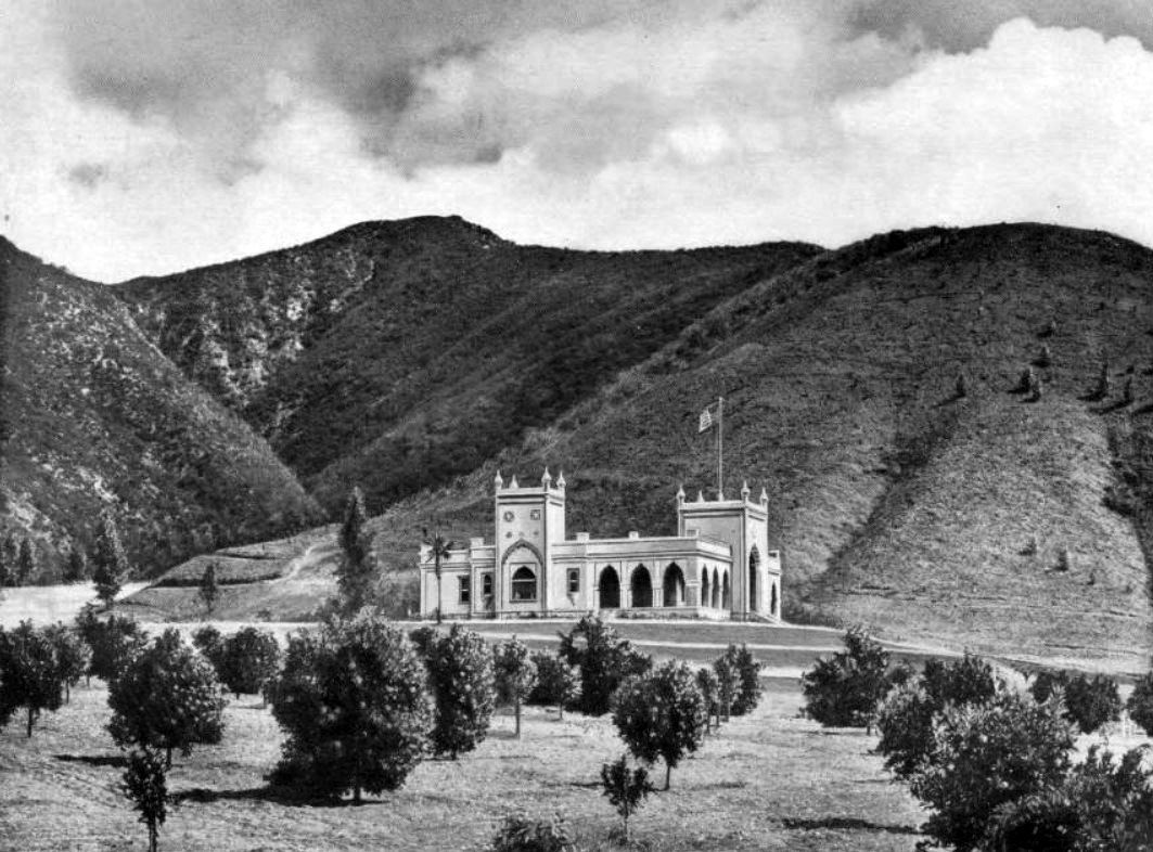
| (ca. 1904)* - View of El Miradero, the newly completed estate of Leslie C. Brand, as seen from the entrance gates of the property. |
Historical Notes Born in Missouri in 1859, Leslie Coombs Brand came to Southern California in 1886 during the region's first great real estate boom. After achieving success in the title insurance and real estate business, he began investing in land on the lower slopes of the Verdugo Mountains overlooking the young community of Glendale. There he assembled an estate of more than 1,000 acres and, between 1903 and 1904, built the magnificent residence he named El Miradero, meaning "The Lookout" or "The Overlook." More than simply a grand home, El Miradero reflected Brand's confidence in Glendale's future. Its commanding hilltop location offered sweeping views across the San Fernando Valley, Griffith Park, and downtown Los Angeles. Local residents soon nicknamed it "Brand's Castle," and today the mansion is preserved as the Brand Library & Art Center, one of Glendale's best-known historic landmarks. |
 |
|
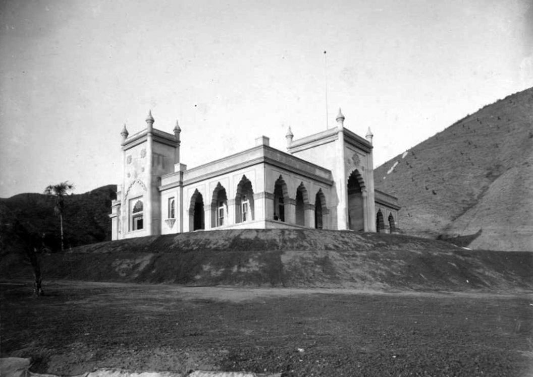
| (ca. 1904)* – West side view of the newly constructed El Miradero, home of Leslie C. Brand. |
Historical Notes Leslie Brand commissioned his brother-in-law, architect Nathaniel Dryden, to design a residence unlike any other in Southern California. Completed in 1904, the mansion was inspired by the East Indian Pavilion displayed at the 1893 World's Columbian Exposition in Chicago. Dryden adapted its exotic appearance into a striking Saracenic design featuring graceful scalloped arches, slender minarets, bulbous domes, and decorative details influenced by Spanish, Moorish, and Indian architecture. Behind its palace-like exterior stood a comfortable thirteen-room family home designed for entertaining. Surrounded by gardens, a greenhouse, stables, a tennis court, and a swimming pool, El Miradero quickly became one of Glendale's best-known landmarks and the center of many of the city's social gatherings. |
 |
|
| (ca. 1906)* – View of El Miradero standing between orange groves in the foreground and the Verdugo Hills in the background. |
Historical Notes When this photograph was taken, Glendale was still surrounded by citrus groves and open countryside. Leslie Brand recognized that reliable transportation would be essential to the community's future and worked with Henry E. Huntington to bring Pacific Electric Railway service to Glendale in 1904. The arrival of the famous Red Cars made the growing town far more accessible to Los Angeles and encouraged the rapid residential and commercial development that soon followed. Brand's influence extended well beyond transportation. He invested in local water, power, and telephone companies, helped guide Glendale's early growth, and played a leading role in shaping the community's modern identity. His lasting contributions are remembered today through Brand Boulevard, Brand Park, and the Brand Library, all of which bear his name. |
 |
|
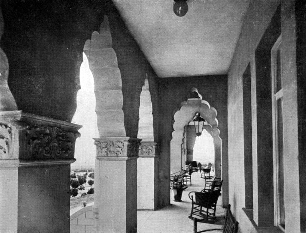
| (ca. 1906)* - View of the covered porch at El Miradero, enclosed by a graceful arcade of scalloped arches. Wicker furniture and potted plants created an inviting outdoor living space overlooking the estate. |
Historical Notes The broad covered porches and open arcades were among El Miradero's most distinctive features, providing shaded outdoor living areas where Leslie and Mary Louise Brand could relax and entertain while enjoying cooling breezes and panoramic views of Glendale, Griffith Park, and the Los Angeles Basin. The mansion was thoughtfully designed to take full advantage of Southern California's mild climate, blurring the line between indoor and outdoor living. Like the rest of the estate, the porch reflected Brand's hospitality. Family, friends, business associates, and civic leaders were frequent guests at El Miradero, where elegant surroundings and sweeping vistas made the mansion one of Glendale's best-known gathering places during the city's formative years. |
A Castle Takes Flight
 |
|
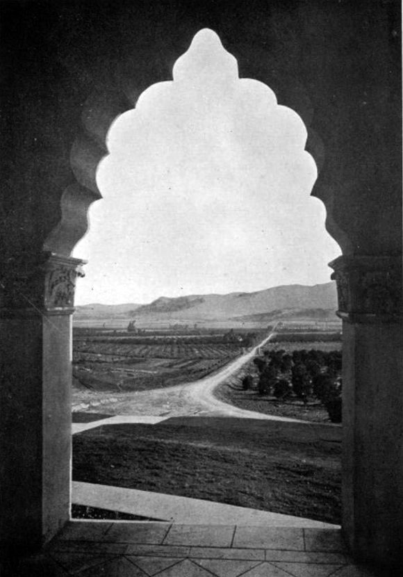
| (ca. 1906)* – View looking south over Glendale and Griffith Park toward Los Angeles through one of the many arches of El Miradero. |
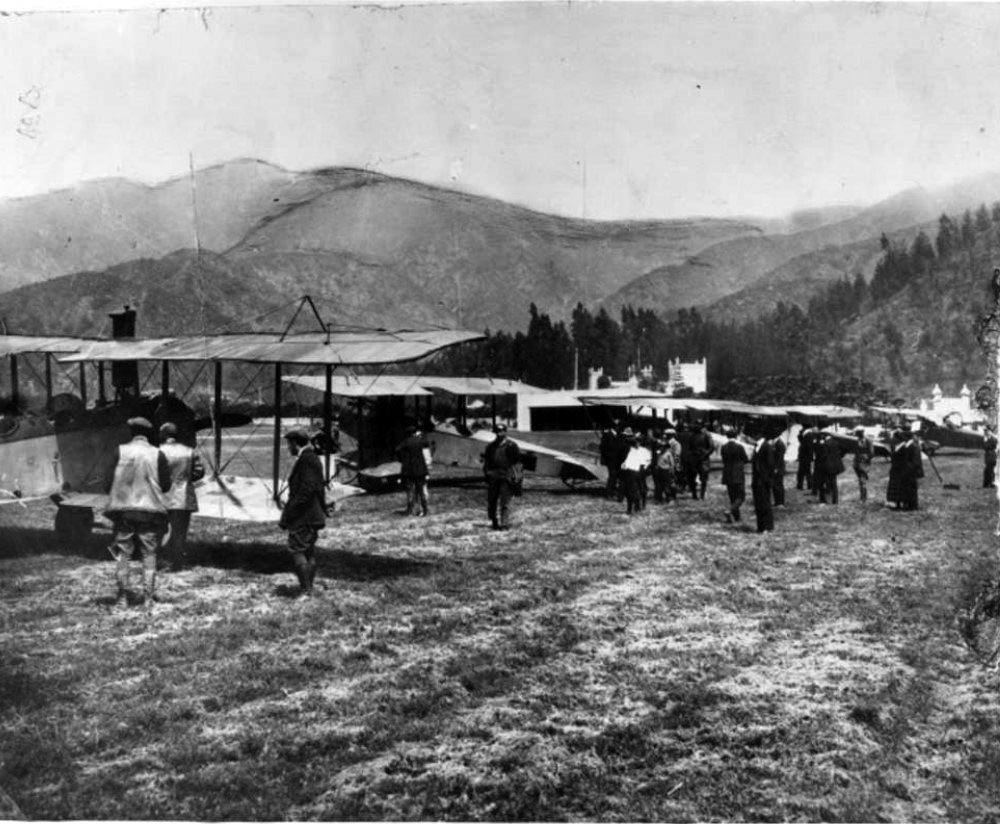
Historical Notes The name El Miradero was well chosen. From the mansion's terraces and arched verandas, Leslie Brand enjoyed sweeping views across Glendale and the valley below toward Griffith Park and downtown Los Angeles. At the time this photograph was taken, the landscape below was still largely rural, with orange groves, scattered homes, and open fields stretching toward the city. Everything changed with the arrival of aviation. In 1912, Griffith Park Aerodrome opened just across the Los Angeles River, well within view of El Miradero. Watching the early airplanes take to the sky sparked Brand's fascination with flight. Within a few years, he transformed part of his own estate into one of Southern California's earliest private airfields, launching a remarkable new chapter in the history of El Miradero. |
 |
|
| (1921)* - Aerial view of L. C. Brand's private airfield in front of his home, El Miradero, in Glendale. Aircraft took off downhill toward Kenneth Road. |
Historical Notes Around 1916, Leslie Brand established a private grass airfield on approximately fifteen acres below El Miradero. Known as Brand Field, it featured a 1,200-foot rolled dirt runway, a distinctive Moorish-style hangar designed to complement the mansion above, and carefully landscaped grounds that reflected Brand's pride in the property. Because of the steep hillside, airplanes took off downhill toward Kenneth Road and landed uphill toward the estate. Brand Field was among the earliest private airfields in Southern California and reflected the excitement surrounding aviation during its pioneering years. What began as a personal hobby soon became one of Glendale's most unusual attractions, drawing aviators from throughout the Los Angeles area and helping establish the city as an early center of aviation. |
 |
|
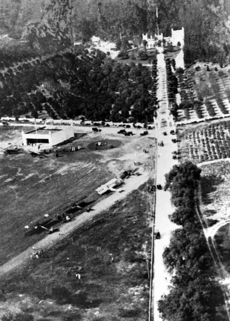
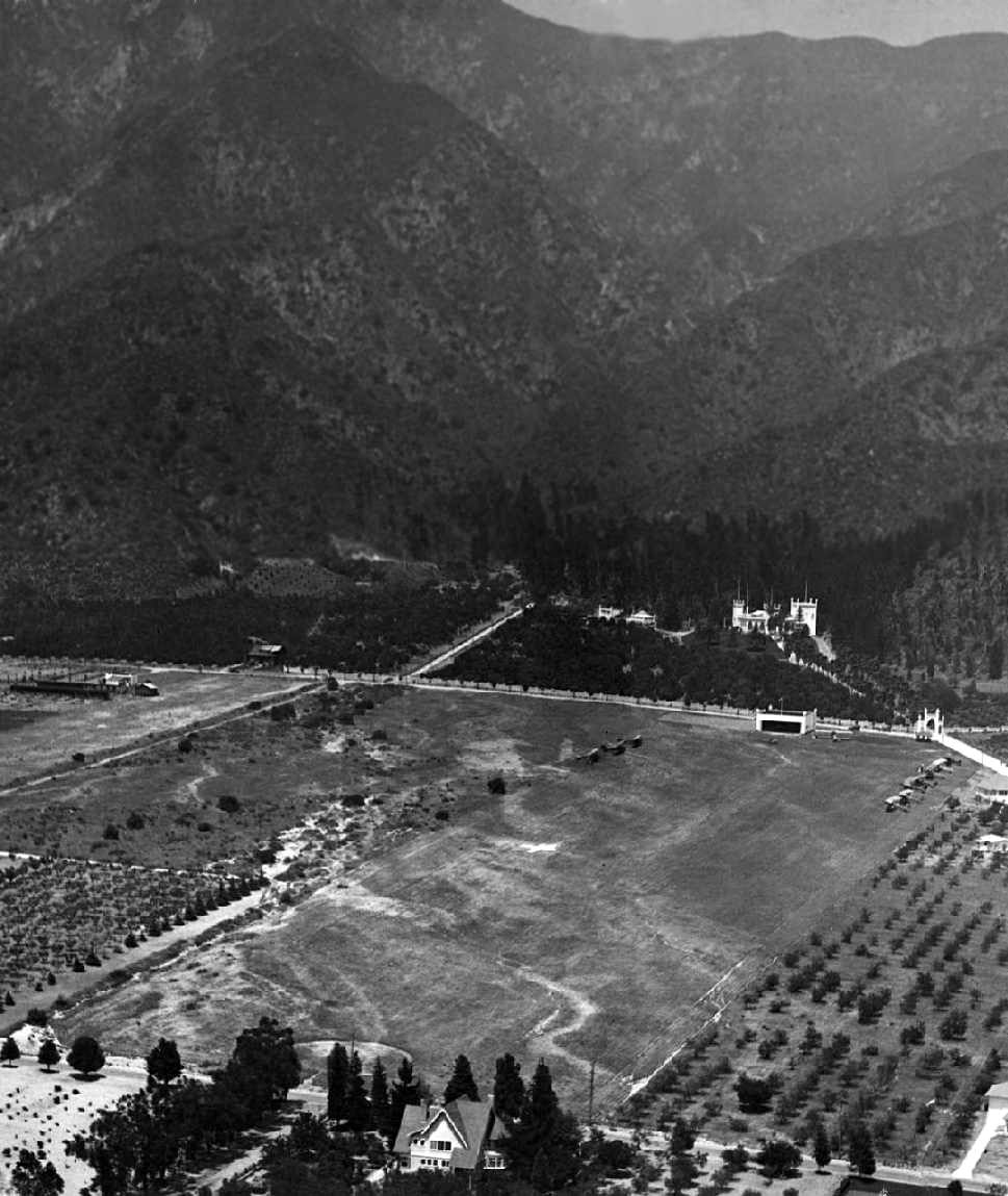
| (ca. 1923)* – Aerial view looking north at Brand Field, showing the hangar and ten aircraft on the field, with El Miradero across the street. Because of the steep terrain, aircraft departed downhill toward the south. |
Historical Notes Although photographs like this one show numerous airplanes gathered at Brand Field, only a few were permanently based there. Most arrived during Brand's popular fly-in gatherings, when pilots from across Southern California landed on the hillside airstrip to enjoy an afternoon of flying, food, and fellowship. Brand also acquired several surplus Curtiss JN-4 "Jenny" trainers following World War I. Like many aviation enthusiasts of the era, he enjoyed restoring, maintaining, and occasionally flying these legendary aircraft, while others remained in storage on the estate. His enthusiasm reflected the nationwide fascination with aviation during the years immediately following the war. |
From Private Estate to Public Legacy
 |
|
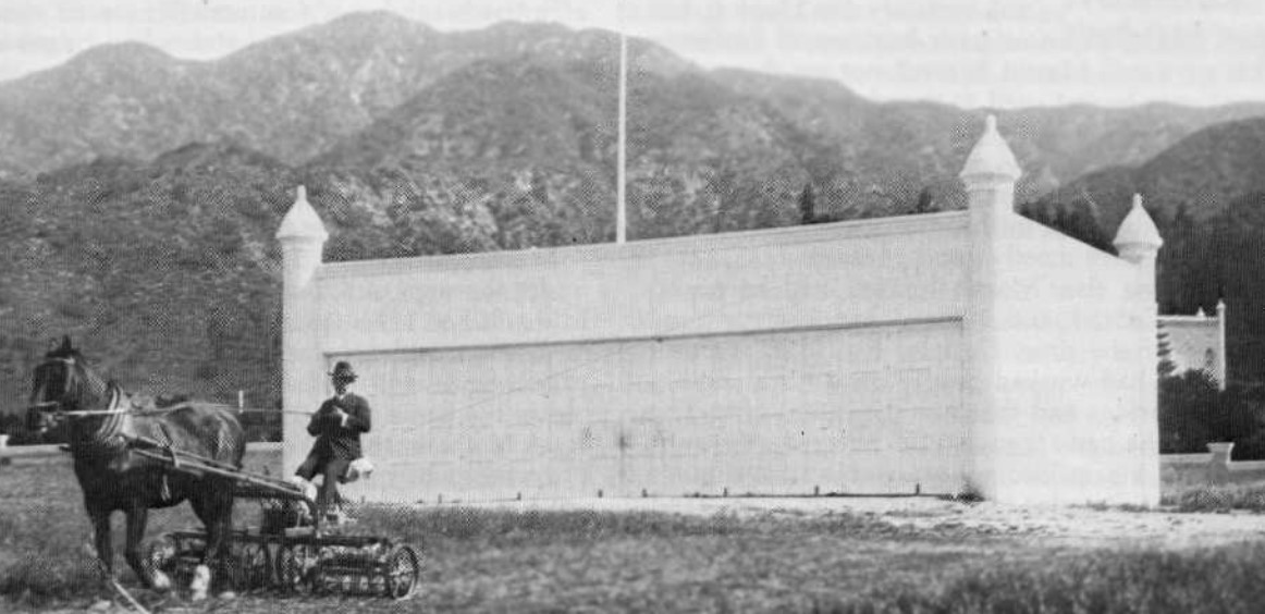
| (ca. 1920s)* – Millionaire Leslie C. Brand mowing the grass in front of the Moorish-style hangar at his private airfield. |
Historical Notes Despite his wealth and success, Leslie Brand took a personal interest in maintaining every aspect of El Miradero. This photograph captures him mowing the grass in front of the Moorish-style hangar, which he built in 1916 to complement the architecture of the mansion above. With its corner turrets and decorative details, the hangar reflected the same distinctive character as the estate itself. Brand's passion for aviation went far beyond owning airplanes. He kept the airfield carefully maintained and welcomed fellow aviators to share his enthusiasm for flying. His hands-on approach reflected the energy and curiosity that had shaped both his business career and his vision for Glendale. |
 |
|
| (1921)* – Airplanes and guests arriving at Brand's fly-in luncheon party on April 1, 1921, with El Miradero seen in the background. Click HERE to see more in Aviation in Early L.A. |
Historical Notes Brand Field became famous for its fly-in luncheon parties, among the earliest aviation gatherings of their kind in Southern California. The only requirement for attending was simple: guests had to arrive in their own airplanes and bring passengers. Pilots from across the Los Angeles area landed on the grassy hillside while visitors gathered beneath the shadow of El Miradero for an afternoon of flying, conversation, and hospitality. These events reflected the optimism and excitement surrounding aviation during the early 1920s. Long before commercial air travel became commonplace, Leslie Brand had transformed his private estate into a welcoming destination where friends shared a common passion for the newest form of transportation. |
 |
|
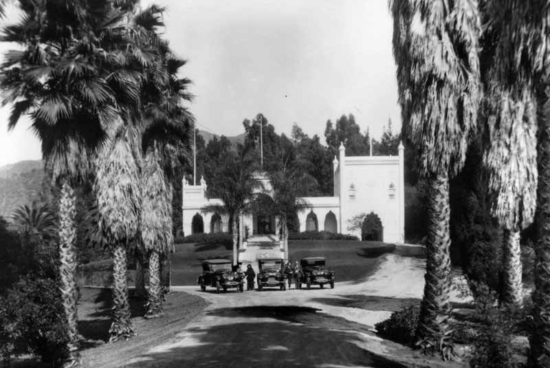
| (ca. 1920)* - View of El Miradero and its estate grounds. Three automobiles are parked where the driveway meets the path to the front door, with three men and one woman standing beside them. |
Historical Notes By the early 1920s, El Miradero had become one of Glendale's best-known landmarks. Surrounded by gardens, orchards, and sweeping lawns, the estate reflected both Leslie Brand's personal success and his enduring belief in Glendale's future. The mansion welcomed civic leaders, business associates, neighbors, and visitors from throughout Southern California, serving as both a family home and a center of community life. As his health declined, Brand began planning for the future of the estate he loved. He arranged for El Miradero and much of the surrounding property to pass to the City of Glendale after the death of his wife, Mary Louise. His gift came with one condition: the estate was to be preserved forever as a public park and library, ensuring that future generations could enjoy the place that had meant so much to him. |
A Lasting Legacy
 |
|
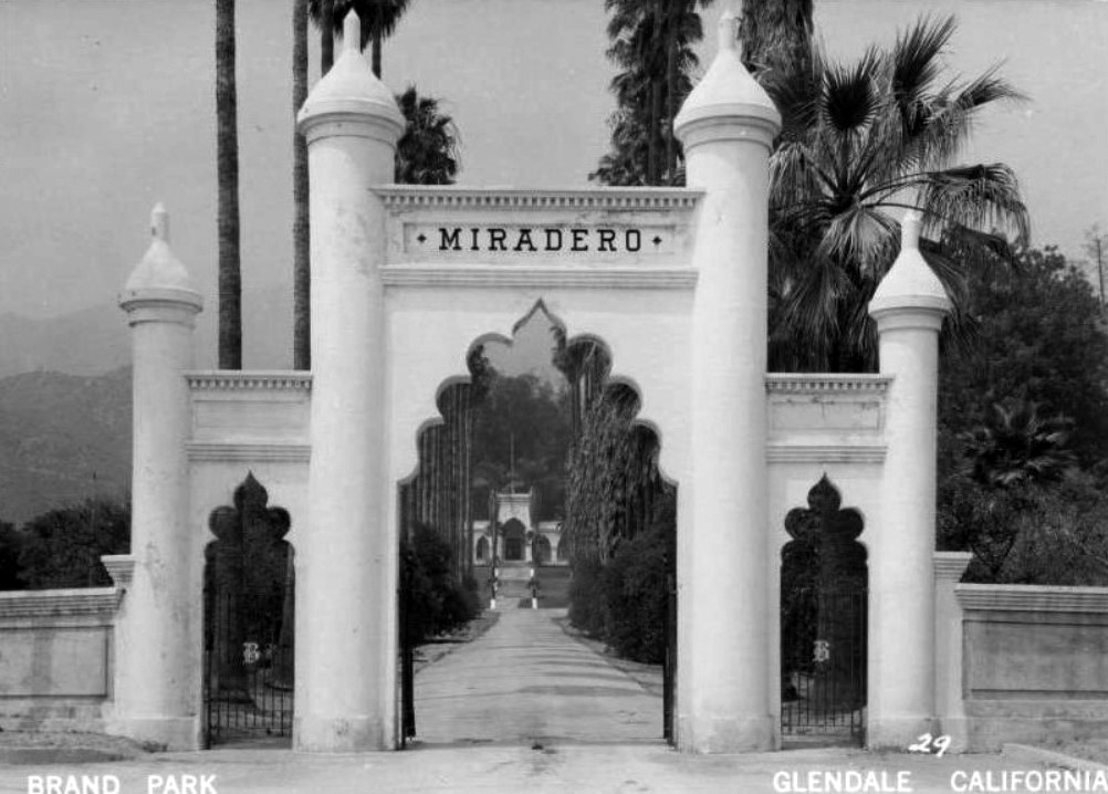
| (ca. 1940s)* - Postcard view of the arched entrance to El Miradero, the former estate of Leslie C. Brand, located in Brand Park. |
Historical Notes Following the death of Mary Louise Brand in 1945, ownership of El Miradero passed to the City of Glendale, fulfilling Leslie Brand's wish that his estate become a public park and library. The grounds were opened to the public, preserving one of the city's most recognizable landmarks for future generations. The graceful entrance gate, with its stone pillars, decorative ironwork, and distinctive "Miradero" arch, has welcomed visitors for more than a century. Beyond it, the mansion began a new chapter in its history. In 1956, El Miradero reopened as the Brand Library, becoming the art and music branch of the Glendale Public Library while retaining the architectural character that has made it one of Southern California's most distinctive historic homes. |
 |
|
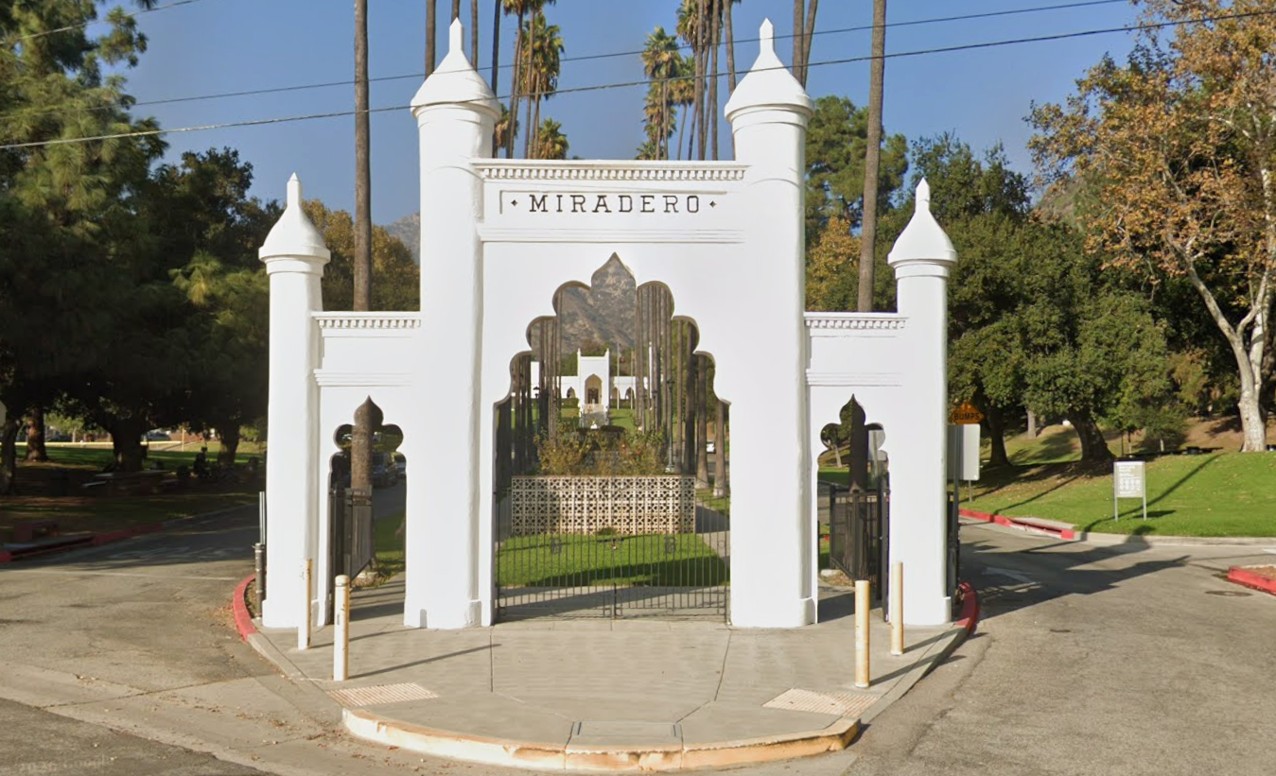
| (2025)* - Contemporary view of the entrance to Brand Park and the Brand Library, the former home of Leslie C. Brand. |
Historical Notes Today, El Miradero remains one of Glendale's cultural treasures. Carefully restored and modernized over the years, the former mansion continues to serve the community as the Brand Library & Art Center, offering art exhibitions, concerts, lectures, and one of Southern California's finest collections of art and music resources. Surrounding the mansion, Brand Park has grown into one of Glendale's most popular public spaces. Visitors can enjoy walking trails, picnic areas, the historic Doctor's House Museum, a Japanese Friendship Garden, and panoramic views of the Verdugo Mountains. High on the hillside overlooking the estate rests Leslie Brand himself, buried beneath a distinctive pyramid-shaped monument that quietly watches over the city he helped build. |
Then and Now
 |
|
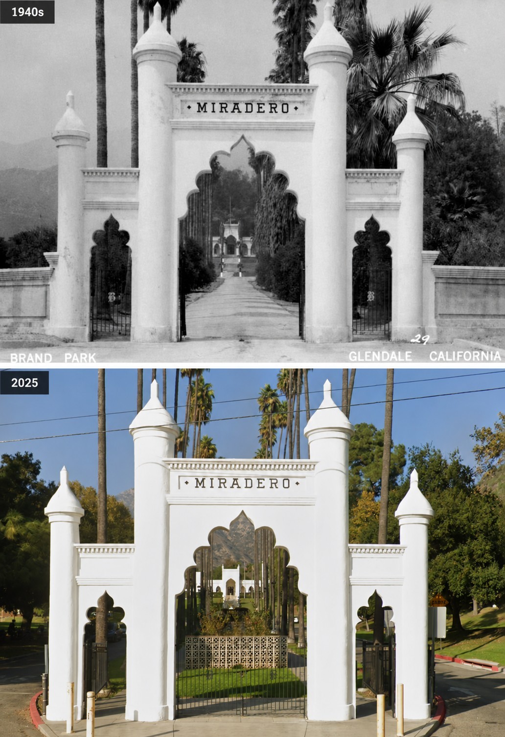
| (1940s vs. 2025)* – The entrance to El Miradero, the former estate of Leslie C. Brand, remains one of Southern California's best-preserved historic estate gateways. Photo comparison my Jack Feldman. |
Historical Notes More than eighty years separate these two views, yet remarkably little has changed. The graceful arch, stone pillars, decorative ironwork, and tree-lined approach remain much as visitors would have experienced them during Leslie Brand's lifetime. While the dirt road has given way to pavement and the surrounding landscape has matured, the entrance continues to convey the same sense of arrival that greeted guests more than a century ago. What was once the gateway to a private estate now welcomes everyone. Leslie Brand's home became Brand Park. His mansion became the Brand Library. His vision became part of Glendale's identity. More than 120 years after El Miradero was built, its greatest legacy is not its architecture, but the generosity of the man who ensured that future generations would always be able to enjoy it. |
Research, writing, and image curation by Jack Feldman, Water and Power Associates, with editorial assistance.
* * * * * |
More Historical Early Views
Newest Additions
Early LA Buildings and City Views
History of Water and Electricity in Los Angeles
* * * * * |
References and Credits
* DWP - LA Public Library Image Archive
^ LA Public Library Image Archive
*^ Wikipedia
^* Glendale High School Home Page
*# Abandoned & Little-Known Airfields – Paul Freeman
#* Flickr.com: Glendale Public Library
#^ Pacific Electric Railway Historical Society
#+ Los Angeles River Flood of 1938
++ Early Glendale (Images of America)
#**Huntington Digital Library Archive
*^^LA Times: Webb's Department Store
+++Facebook: Vintage Glendale "The Jewel City"
^*^Nuestra Señora la Reina de los Ángeles: losangelespast.com
^^*Cinema Treasures: Palace Grand Theatre
***PhantomLosAngeles.blogspot.com: Glendale Southern Pacific Railroad
^x*Facebook.com: So. Calif. Historic Arrchitecture
^*#California State Library Image Archive
^##Metropolitan Transportation Library and Archive
+##Airport Journals: Grand Central Aiport
#^*Flickr.com: Michael Ryerson
##^CSUN Oviatt Library Digital Archives
##*OAC - Online Archive of California
^##^Glendale Historical Society
#+#+Glendale News-Press: Tropic
#*#^Brand Park and Studios: glendale.ca.us
***^CSUN Oviatt Library Digital Archives
#+++Facebook.com: West San Fernando Valley Then And Now
##^*Facebook.com: Classic Hollywood-Los Angeles-SFV
< Back