Early Los Angeles City Views (1800s)
From Pueblo to Growing City
Historical Photos of Early Los Angeles |
Introduction |
This section brings together a wide range of 1800s city views that show Los Angeles in its earliest stages, from a compact pueblo centered on the Plaza to a growing town extending into new streets, businesses, schools, and transportation routes. Rather than focusing on a single event, these images follow the city’s physical form and daily life as it changed over time, using photographs, sketches, maps, and panoramic views to document what early residents saw and experienced.The views that follow include early depictions of the Plaza and surrounding adobes, the first street grid and landmark blocks, and key corridors such as Main Street, Spring Street, Aliso Street, and Commercial Street. They also illustrate the systems that supported early growth, including water infrastructure tied to the Los Angeles River and the Zanja Madre, along with later signs of modernization such as gas lighting and the city’s first electric streetlights. Additional images expand beyond the pueblo to San Pedro and Wilmington, showing the development of the harbor and its role in connecting Los Angeles to regional and global trade.By 1850, Los Angeles occupied only a small corner of the vast basin that would eventually bear its name. Adobe structures, vineyards, and open countryside stretched in every direction from the Plaza, and the surrounding landscape still retained much of the character of the Spanish and Mexican periods that had shaped it. Together, these scenes trace the city from those first years, showing not just what was built, but how a community organized itself around water, land, and the rhythms of daily life in a place still finding its form. |
In This Section
* * * * * |
The Pueblo Takes Shape |
Rare views showing Los Angeles as it appeared around 1850. |
 |
|
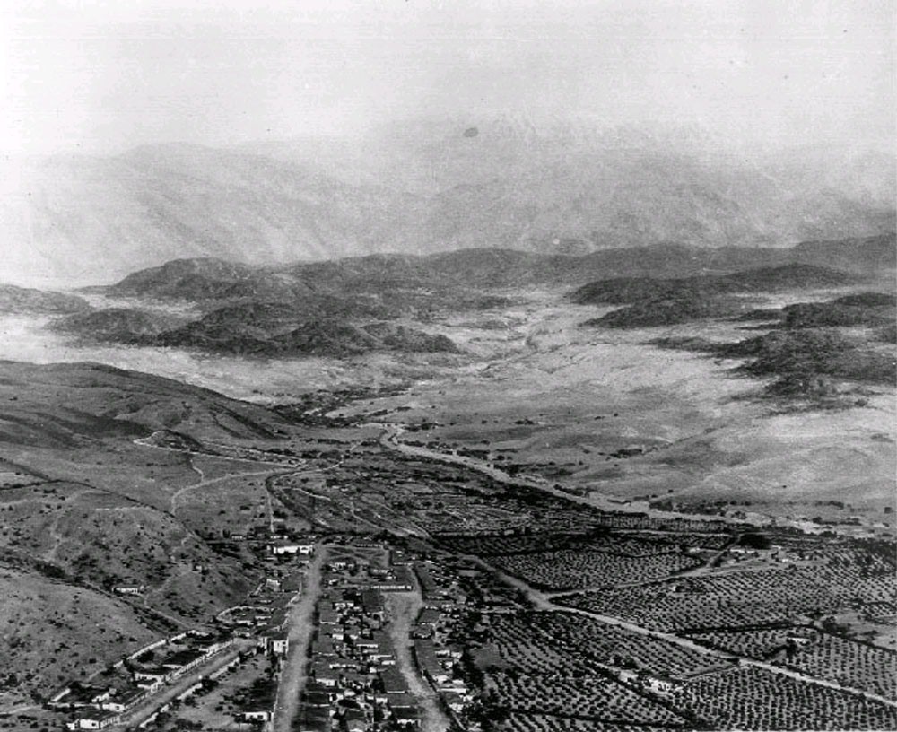
View showing a model of Los Angeles as it appeared in 1850. Looking northeast, the layout of the new city can clearly be seen with the Los Angeles Plaza located in the lower left center. The large white structure to the left of the Plaza is the Old Plaza Church. The two streets running from the bottom of the model to the Plaza are Main Street on the left and Los Angeles Street on the right. Alameda Street runs from the lower right corner diagonally toward the lower center. The Los Angeles River can be seen running from the lower right toward the center, where it turns left and disappears behind the mountain. The Arroyo Seco joins the river at that point. Vineyards blanket the area between the city and the river. The large dark spot in the lower right is El Aliso, the historic sycamore that once marked the Tongva village of Yangna. The San Gabriel Mountains rise in the distance. Note: Picture file card identifies the above image as a diorama of the Pueblo of Los Angeles as it appeared in 1850, designed by J. Marshall Miller. The file card also reads “Prepared for the Los Angeles Times Anniversary 1931?”.* |
Historical Notes The City of Los Angeles began here. Nuestra Señora Reina de los Angeles was founded on September 4, 1781, by a group of Spanish pobladores consisting of 11 families, a total of 44 men, women, and children. They were originally led by Fernando Javier Rivera y Moncada and accompanied by soldiers sent from Mission San Gabriel Arcángel to establish a pueblo near the Porciuncula River at the Tongva village of Yangna. In 1841, Los Angeles’ first census recorded a population of 141. Gold was discovered in 1842 at Placerita Canyon near Mission San Fernando, and the larger Gold Rush era that followed brought new arrivals. By 1850, the population had reached 1,610. |
 |
|
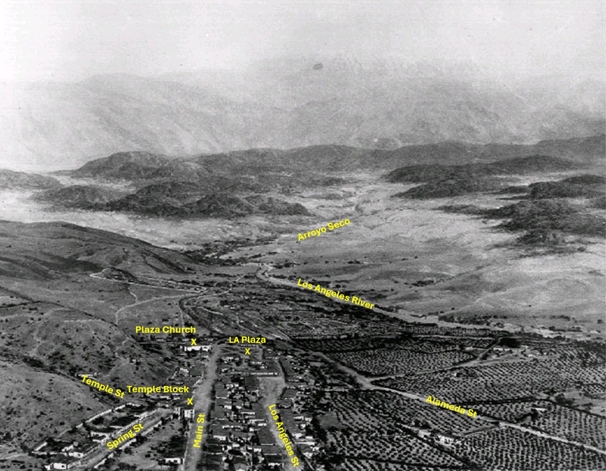
| (1850)* - Aerial view looking northeast across the site of early Los Angeles, with major landmarks labeled. The Plaza, Old Plaza Church, Temple Block, and the main north south streets appear in the foreground. The Los Angeles River and the Arroyo Seco flow through the center distance, with the San Gabriel Mountains rising behind them. Annotated by Jack Feldman. |
Historical Notes By 1850, the physical framework of the pueblo was already taking shape. The Plaza served as the social and civic center of the settlement, with the Old Plaza Church beside it as the town’s most familiar building. Temple Block marked the western edge of the early business district and remained an important focal point for decades. Main Street, Spring Street, Los Angeles Street, and Alameda Street made up the earliest street grid. Much of the flat land east of the Plaza was planted in vineyards and orchards, long before large scale urban development transformed the region. The Arroyo Seco joined the Los Angeles River just north of the pueblo. This natural water system supported both the Zanja Madre and later water projects that helped the community expand. Early residents often described the valley as a fertile plain set at the foot of a dramatic mountain range. |
* * * * * |
As the pueblo grew, the Plaza remained its center of gravity, the place where civic life, commerce, and the routines of daily existence converged. For the earliest residents, the square was not simply a geographic feature; it was the point from which the city measured itself. |
The Plaza and Early Los Angeles
.jpg) |
|
| (ca. 1850)* - Photo of a sketch showing the LA Plaza and surrounding area as it appeared in 1850. The Old Plaza Church is seen at upper left. The map is based on the 1849 Ord Survey. |
Historical Notes The Ord Survey of 1849 was the first detailed map of the pueblo created under United States authority. It documented the shape of the Plaza, the position of the church, and the alignment of the early streets. Many of the lots shown would later become the center of the growing business district. The sketch reflects a community still organized around Spanish and Mexican planning traditions, with the Plaza as its focal point. Click HERE to see more in an Interactive Map of Early Los Angeles as it appeared in 1850. |
 |
|
| (ca. 1858)* - This is the earliest known close-up photograph of the Los Angeles Plaza. There is a square main brick reservoir in the middle of the Plaza, which was the terminus of the town's historic lifeline: the Zanja Madre ('Mother Ditch'). The reservoir was built in 1858 by the LA Water Works Company. |
Historical Notes The site of the Plaza today is not the original location. Earlier plazas preceded it, and one is believed to have been located near the area now occupied by Pershing Square. At least one earlier site is thought to have been lost to flooding. The current Plaza dates from approximately 1815. When early settlers arrived at the Los Angeles River by way of Mission Road, they chose as a nearby gathering point a massive sycamore that gave them shelter and became a landmark known as "El Aliso." That Spanish word for sycamore was later used to name Aliso Street, laid out near the river in 1854. El Aliso sprang from the ground near the western bank of the Los Angeles River in the late fifteenth century, around the same time Columbus arrived in the Americas. Over the centuries, the tree became a gathering place for the Tongva people and stood near the center of Yangna, one of the region's largest Indigenous settlements. By the mid nineteenth century, however, the expanding pueblo had begun transforming both the landscape and the traditional life that once centered around the tree. As the settlement expanded and formal water distribution became necessary, several private water companies operated in Los Angeles during this period under shifting names and franchise agreements, reflecting the evolving nature of the city's early water system before municipal ownership. |
 |
|
| (ca. 1858)* - Close view of the Los Angeles Plaza in 1858 with the central brick reservoir and nearby adobe buildings. The Carrillo Adobe stands at lower right. It was demolished in 1870 to clear the site for the future Pico House. Colorized by Richard Holoff. |
Historical Notes From this vantage point the early heart of Los Angeles is clearly visible. The reservoir marked the end of the Zanja Madre and supplied water to the growing settlement. The Carrillo Adobe, one of the older structures near the Plaza, belonged to the family of Carlos Carrillo. Its removal in 1870 made way for the Pico House, which became one of the most significant buildings of early American Los Angeles. The Plaza area continued to evolve in the years after this photograph was taken. New businesses, hotels, and public buildings soon surrounded the square, and the community began expanding beyond its original boundaries toward Temple Block and the later civic center. Click HERE to read more about the Zanja Madre and Los Angeles' first water supply. |
* * * * * |
Water Infrastructure and the Zanja Madre |
Beneath the visible city ran an invisible one: the network of ditches, water wheels, and reservoirs that made permanent settlement in this dry landscape possible. The Zanja Madre, or Mother Ditch, was not merely a utility. It was the thread that connected the Los Angeles River to the Plaza, and through the Plaza, to the life of every household and garden in the pueblo. |
.jpg) |
|
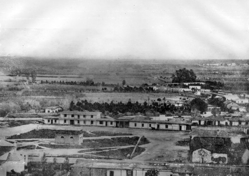
| (ca. 1860)* - One of Los Angeles' first water reservoirs was the brick structure shown in the center of the Plaza. The adobe directly behind was owned by Augustin Olvera. The 3-story building behind was the Sisters of Charity Hospital. |
Historical Notes In 1858, the LA Water Works Co., headed by William G. Dryden, constructed a large brick and wood storage tank in the center of the city plaza. It would remain there for about 10 years and then be replaced by a fountain. Water would continue to be stored in other tanks on the periphery of the plaza as well as in other nearby reservoirs. In 1876, the Buena Vista Reservoir in Elysian Park was built by the privately-owned Los Angeles Water Co. The LA Water Co., headed by John S. Griffen, Solomon Lazard, and Prudent Beaudry, signed a 30 year lease franchise agreement with the City to run its water system (1868 - 1898). Click HERE to read more in Water in Early Los Angeles. Click HERE to see more in Early LA Water Reservoirs. |
 |
|
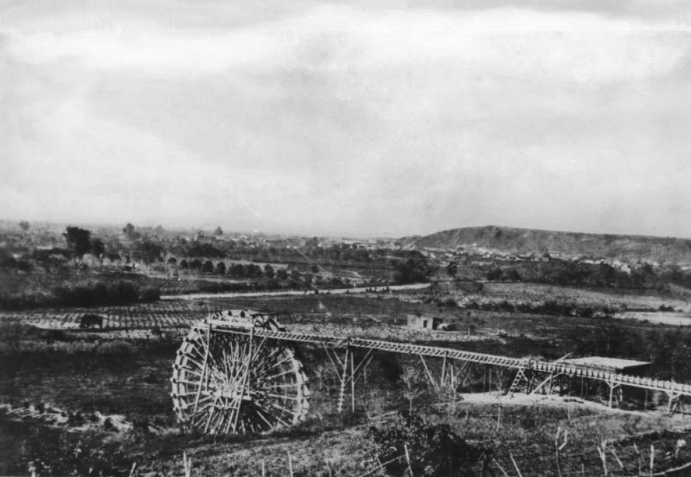
| (1863)^ - A water wheel on the Los Angeles River at start of Zanja Madre, LA's original aqueduct. The river has been the life-source of Los Angeles since it was settled in 1781. |
Historical Notes The 40-foot water wheel seen above was used to raise a portion of the Los Angeles River water supply to a height permitting gravity flow to homes, fields, and storage reservoirs. In 1857, William Dryden was granted a franchise by the City Council to construct a system to provide a municipal water supply. Under this system, a brick reservoir was built in the center of the Plaza to store the water brought there by the Zanja Madre. A water wheel was also constructed to lift water from the river into the ditch system. From there, water was distributed to homes along the principal streets through a network of wooden pipes. Though primitive by modern standards, the system formed the foundation of Los Angeles' earliest organized water infrastructure. |
 |
|
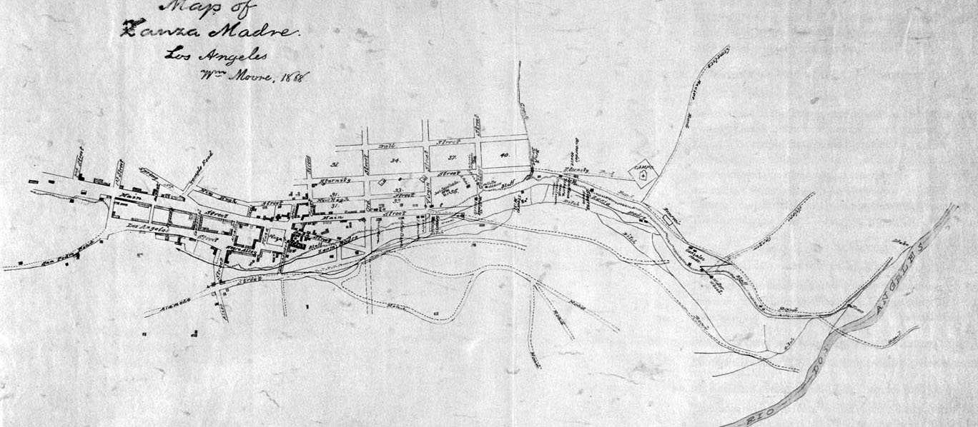
| (1868)^ - This manuscript map traces the path of the essential lifeline of early Los Angeles: the Zanja Madre, or Mother Ditch, prepared by cartographer William Moore. |
Historical Notes The Zanja Madre is shown here from the river at the right edge of the map, running along the bluffs near present-day North Broadway completely open to the elements. A few years after this rendering, a brick tunnel enclosed portions of the ditch in an effort by the Common Council and the Los Angeles City Water Company to better preserve the precious flow coming from the river. The map also identifies the Campo Santo cemetery at the end of Eternity Street, the water wheel that propelled water toward the pueblo, and the homes of early pioneers including Jose Sepulveda, Abel Stearns, and Bernardo Wilson. Click HERE to see more in Zanja Madre - LA's Original Aqueduct |
 |
|
| (ca. 1868)^ - The Plaza, looking east, with Los Angeles' first above-ground reservoir visible at right. The two-story building directly behind the reservoir is the Vincent Lugo Adobe. The structure with the gazebo-like tower in front of the reservoir is the Old Plaza Church. |
Historical Notes The Lugo Adobe, believed to have been built in the 1840s by Don Vicente Lugo, was one of the very few two-story residences in the pueblo of Los Angeles. In 1867, Lugo donated the building on the Plaza to St. Vincent's School, a predecessor of Loyola University. The reservoir visible in the photograph reflects the increasing importance of organized water storage as Los Angeles continued to grow during the second half of the nineteenth century. |
 |
|
| (n.d.)* - Map showing the Los Angeles Plaza area as it appeared in 1860. Adobe structures dominate nearly all sides of the square. |
Historical Notes This map captures the Plaza area at a moment when adobe construction still dominated the surrounding blocks. Lots are shown in their early configuration, with commercial and residential uses intermixed along the principal streets. The predominance of adobe structures reflects building traditions carried forward from the Spanish and Mexican periods, which persisted well into the American-era before brick and wood-frame construction gradually replaced them. |
| From Water System to City Center
The Zanja Madre and its reservoirs supplied the water that allowed Los Angeles to grow, but the Plaza remained the center of community life. Surrounded by churches, adobes, businesses, and public gathering places, it was here that the young pueblo evolved into an emerging American city. The images that follow explore the Plaza and its surroundings during that period of transformation. |
* * * * * |
Los Angeles Plaza (1850–1870) |
The Los Angeles Plaza was the historic heart of the young pueblo and remained the center of civic, commercial, religious, and social life throughout much of the nineteenth century. Surrounded by adobe homes, businesses, hotels, and public gathering places, the Plaza served as the focal point from which the growing town expanded. Residents gathered here for celebrations, religious observances, public announcements, and everyday commerce, making it the community's most important public space.The images in this section document the Plaza and its immediate surroundings during a period of significant change. They capture the Old Plaza Church, Wine Street (later renamed Olvera Street), some of the city's oldest surviving adobes, the community water system, and the newly constructed Pico House. Together, these views provide a detailed look at the historic center of Los Angeles as it evolved from a Mexican-era pueblo into an emerging American city. |
 |
|
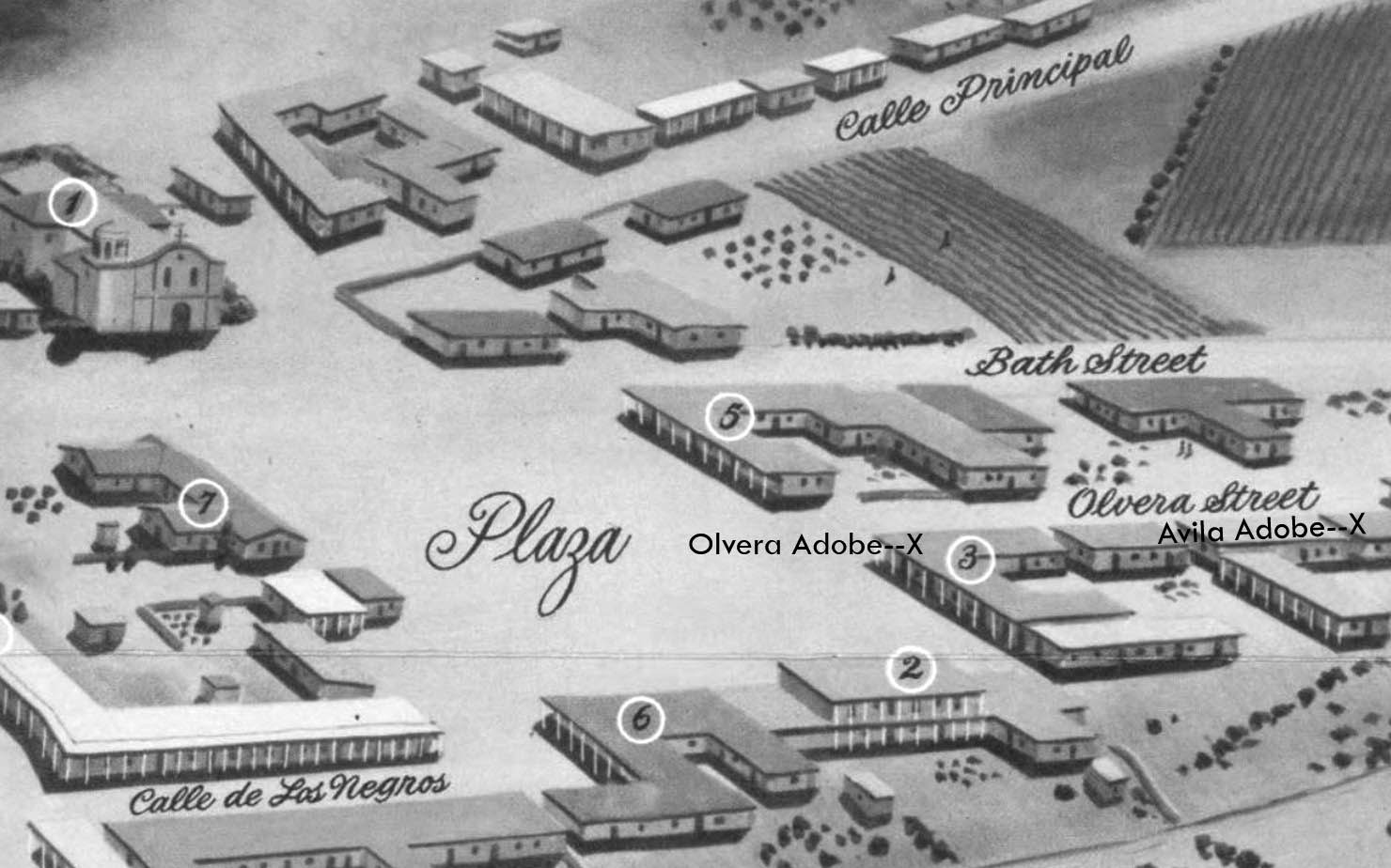
| (1850)* - Map looking northwest showing the Los Angeles Plaza and surrounding area as it appeared in 1850. Olvera Street, then known as Wine Street, is visible at right at its intersection with the Plaza, with the locations of the Olvera Adobe and the Avila Adobe marked. The Old Plaza Church appears in the upper left corner. |
Historical Notes This map serves as an introduction to the historic core of Los Angeles and helps orient the reader to the photographs that follow. In 1850, Los Angeles had only recently become part of the United States following California statehood. With a population of approximately 1,600 residents, it remained a small community centered around the Plaza and the surrounding adobe buildings that reflected the city's Spanish and Mexican heritage. Several landmarks shown on the map would become enduring symbols of early Los Angeles, including the Old Plaza Church, the Avila Adobe, and the Olvera Adobe. Although the city would expand dramatically during the decades that followed, the Plaza remained the symbolic and physical center of Los Angeles throughout much of the nineteenth century. |
 |
|
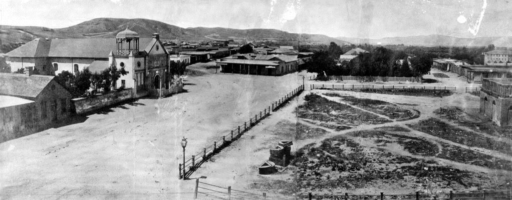
| (1869)* - Panoramic view of the Plaza and the Old Plaza Church, formally known as La Iglesia de Nuestra Señora Reina de los Ángeles. In the center foreground, partially visible, is the brick water reservoir constructed by William Dryden and his Los Angeles Water Works Company. The two gas lamps visible on the corners of the Plaza were among the first street lights installed in Los Angeles. |
Historical Notes This panoramic view captures the Plaza at a pivotal moment in the history of Los Angeles. The brick reservoir visible in the foreground was constructed by William Dryden and his Los Angeles Water Works Company following a franchise granted by the City Council in 1857. Fed by the Zanja Madre, the city's original irrigation ditch connected to the Los Angeles River, the reservoir stood at the center of the Plaza and provided an elevated distribution point for the city's earliest domestic water supply. The reservoir remained in place until 1870, when the Council ordered its removal as part of broader improvements to the Plaza. The two gas lamps visible on the Plaza corners represent another milestone in the city's early infrastructure, marking the introduction of street lighting to Los Angeles. The three adobe structures visible along the north side of the Plaza reflect the Spanish and Mexican heritage of the old pueblo. In 1869 they were owned by M. Norton, John Downey, and Augustin Olvera respectively, and dated from construction periods spanning 1844 to 1854. None survive today. The Norton adobe was lost to the widening of Main Street, the Downey adobe was demolished in 1894 to make way for the Simpson-Jones Building, and the Olvera adobe came down in 1916 and was replaced by the Plaza Methodist Church. In the upper right background, the Sisters of Charity Hospital is also visible, one of the early institutions that gathered near the historic center of the city. The two gas lamps seen on the corners of the LA Plaza were the first streetlights installed in Los Angeles. Click HERE to see more in Early LA Streetlights. Click HERE to read more on Wiliam Dryden. |
 |
|
| (ca. 1869)* - View of the edge of the Los Angeles Plaza and the entrance to Wine Street, renamed Olvera Street in 1877, looking north from the Pico House. The Avila Adobe is visible on Wine Street. The Olvera Adobe can also be seen at right. In the foreground, a wrought-iron fence and a post-and-rail fence run horizontally on either side of the street. |
Historical Notes The narrow street visible in this photograph was known as Wine Street at the time of this image, a name derived from the vineyards and wine production that once characterized this part of the early pueblo. It was renamed Olvera Street in 1877 in honor of Agustín Olvera, a prominent early Los Angeles judge and civic figure. The street remained a modest commercial and residential corridor for decades before Christine Sterling led a successful effort to preserve and restore it as a cultural landmark, opening it to the public as a Mexican marketplace on Easter Sunday in 1930. The Avila Adobe, visible on the left side of the street, was built in 1818 by Don Francisco Avila, a wealthy cattle rancher and one-time mayor of the Pueblo of Los Angeles. It stands today as the oldest surviving residence in Los Angeles and one of the city's most important historic structures. At the time of this photograph, the adobe had already been standing for more than fifty years, a remarkable survivor of the rapid changes reshaping the city around it. |
 |
|
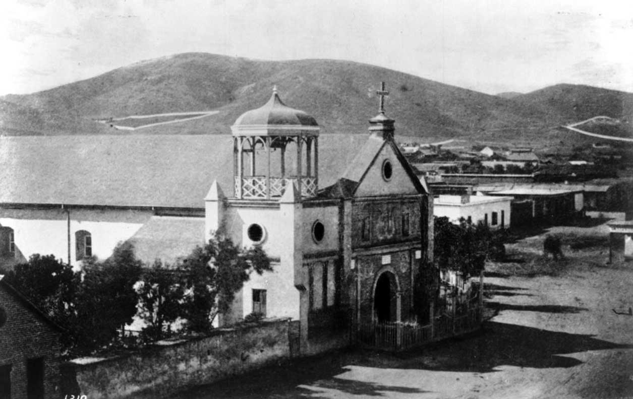
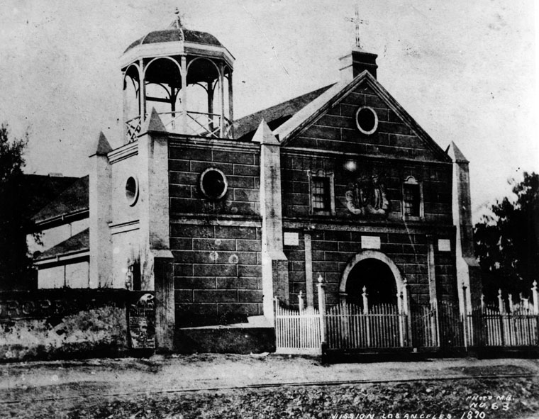
| (1869)* - View of the Old Plaza Church, formally known as La Iglesia de Nuestra Señora Reina de los Ángeles, with bare hills visible in the background. The hills at left above the church mark the area of Chavez Ravine, where Dodger Stadium stands today. |
Historical Notes The Old Plaza Church has stood at the center of Los Angeles religious and community life since its dedication on December 8, 1822. Its origins trace to 1814, when Franciscan Fray Luis Gil y Taboada placed the cornerstone for a new church on the site of an earlier adobe asistencia established in 1784 to serve the founding settlers of the pueblo. The completed structure was rebuilt using materials from the original church in 1861, and the title Reina, meaning Queen, was added to its name in later years. For generations it served as the principal Roman Catholic church in Los Angeles, earning the affectionate nicknames La Placita and Plaza Church. The church was one of the first three sites designated as Historic Cultural Monuments by the City of Los Angeles and is also California Historical Landmark No. 144. It remains one of the oldest and most recognizable landmarks in the city. |
 |
|
| (1870)^ - Close-up view of the front entrance to the Old Plaza Church. The Los Angeles Plaza is visible across the street. |
Historical Notes This close-up view captures the church shortly after its 1861 reconstruction. The gazebo-like bell structure above the entrance replaced the original three-bell campanario, or bell wall, that had characterized the church since its 1822 dedication. The traditional bell wall would return during a major remodeling around 1901, restoring an architectural feature more closely associated with the church's original appearance. By 1870, the Plaza Church stood at the center of a rapidly changing neighborhood. The Pico House had just opened across the Plaza, bringing new commercial activity to the district, while Los Angeles itself was beginning its transformation from a small pueblo into a growing American city. Despite these changes, the church remained a constant presence in the life of the community. Click HERE to see more on the Old Plaza Church. |
 |
|
| (1869)* - View showing the Pico House, Masonic Lodge, and the Plaza area as seen from Fort Moore Hill. In the foreground is a community of small residences. The Pico House faces Main Street just beyond the foreground houses, with the Plaza visible to its left. The Masonic Lodge stands two buildings to the right of the Pico House. |
Historical Notes The Pico House, visible in this view facing Main Street at the Plaza, was constructed between 1869 and 1870 by Pio Pico, the last governor of Mexican California. Designed by architect Ezra F. Kysor, it became Los Angeles' first three-story hotel and immediately established a new standard of luxury for the growing city. Its eighty-two guest rooms, twenty-one parlors, two interior courtyards, and ground-floor French restaurant made it one of the most ambitious building projects in early Los Angeles. To finance its construction, Pio Pico sold much of his extensive San Fernando Valley landholdings, reflecting the broader transition from the rancho economy of Mexican California to the commercial ambitions of the American era. The hotel quickly became a center of business and social life and stood as a symbol of Los Angeles' emergence as a modern city. |
* * * * * |
Los Angeles in 1871 |
The year 1871 offers a revealing snapshot of Los Angeles at a pivotal moment in its development. With a population of approximately 5,700 to 6,000 residents, the city was small by any measure, yet it was already experiencing the growing pains of rapid change. The old pueblo character of the Spanish and Mexican eras was giving way to an increasingly American city, with new commercial buildings, hotels, gas lighting, and civic institutions reshaping the landscape around the historic Plaza.The documents and images presented here record the city at that moment from two different perspectives: a detailed bird's-eye map created in 1929 by the Women's University Club of Los Angeles to reconstruct how the city appeared in 1871, and a contemporary lithograph showing the Plaza district and the agricultural landscape that still surrounded the compact urban core. Together they provide a remarkably complete picture of Los Angeles on the threshold of the explosive growth that would transform the city during the final decades of the nineteenth century. |
Los Angeles as it Appeared in 1871
 |
|
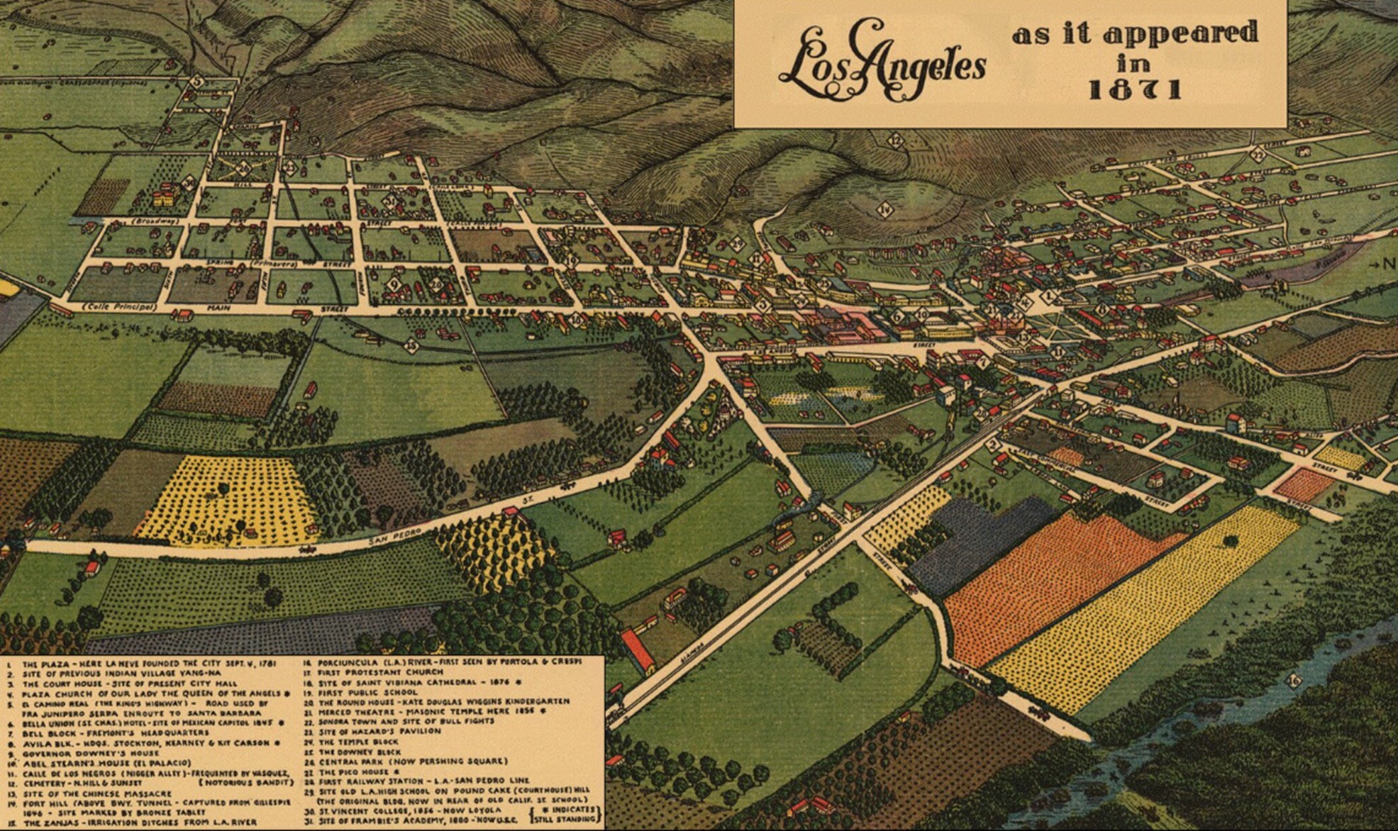
| (1871)* - Los Angeles as it appeared in 1871. This bird's-eye view map was created in 1929 by the Women's University Club of Los Angeles and approved by the Historical Society of Southern California. It includes colored illustrations, historic notes, an index to points of interest, and a submap showing the original Spanish land grant ranchos. Source: Library of Congress. |
Historical Notes This map was produced in 1929 as a carefully researched historical reconstruction of Los Angeles as it appeared nearly six decades earlier. Created by the Women's University Club of Los Angeles and approved by the Historical Society of Southern California, it represents one of the most detailed visual records of the early city produced during the twentieth century. The map is a perspective view rather than a strictly accurate survey, drawn in the bird's-eye tradition popular in the nineteenth century, and is not to scale. Its value lies in its identification of specific buildings, streets, institutions, and landmarks that characterized downtown Los Angeles in 1871, many of which had already disappeared by the time the map was made. In 1871, Los Angeles was still organized tightly around the historic Plaza, with most commercial and civic activity concentrated along Main Street, Spring Street, and a handful of connecting thoroughfares. The surrounding landscape remained largely agricultural, with orchards, vineyards, and open land extending outward from the compact urban core in nearly every direction. The map captures this transitional moment with particular clarity, showing a city that was unmistakably urban at its center yet still deeply connected to the rural landscape from which it had grown. Readers may notice that the Plaza is shown in its original rectangular form rather than the circular landscaped configuration visible in photographs from the early 1870s. Although the map depicts Los Angeles as it appeared in 1871, the Women's University Club reconstruction appears to rely on earlier source material for the Plaza layout and should not be interpreted as an exact survey. By this time, improvements associated with the Los Angeles City Water Company had already begun transforming the Plaza into the landscaped circular park seen in later photographs. |
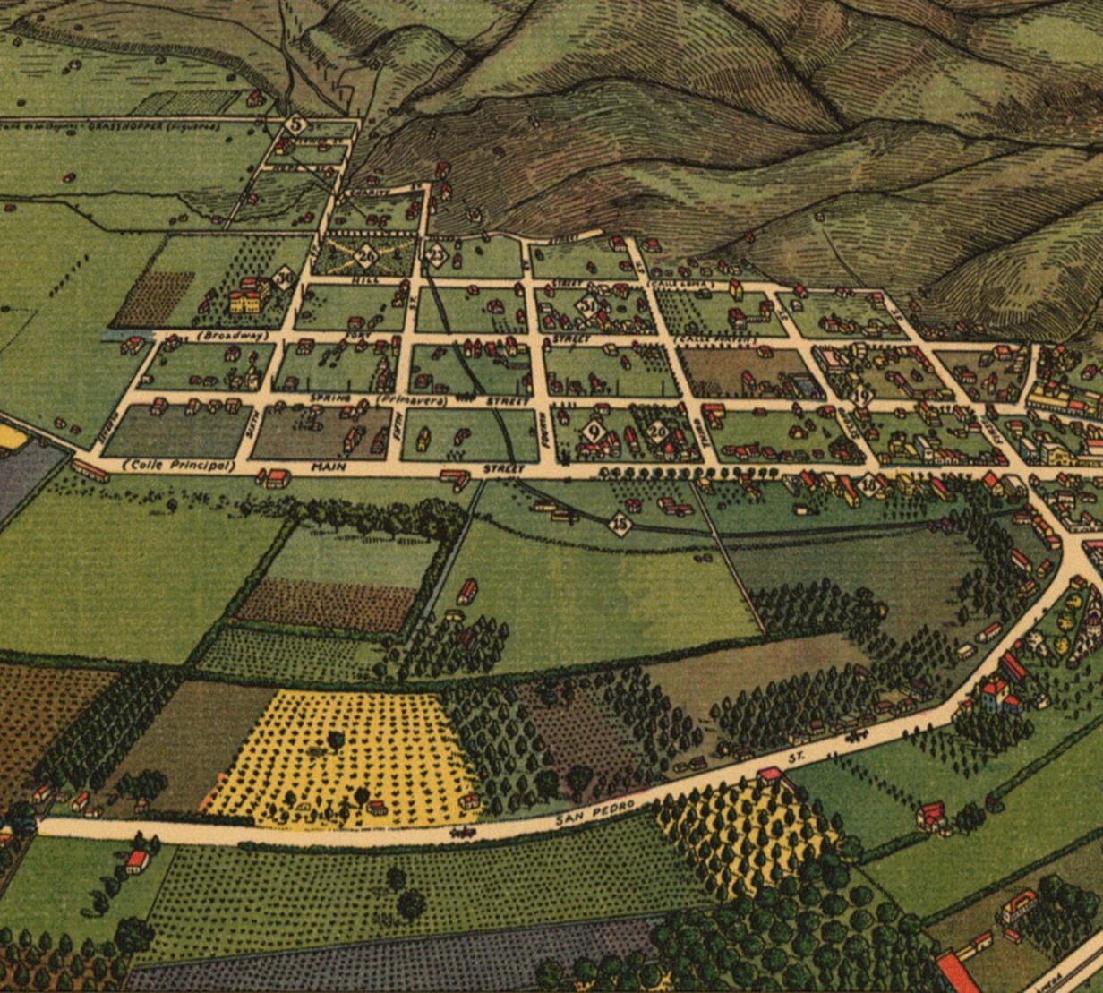
North End of Los Angeles in 1871
 |
|
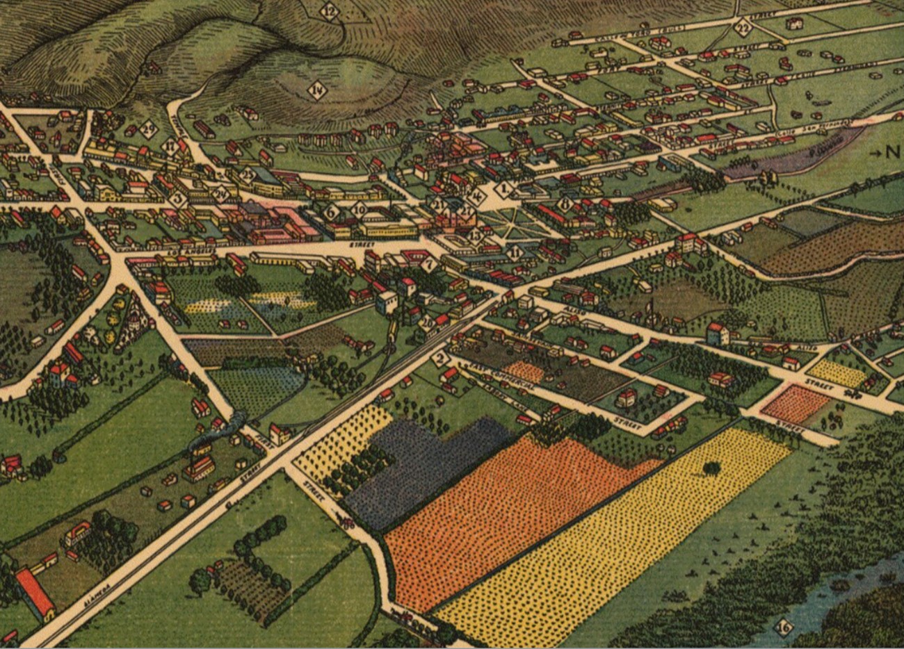
| (1871)* - Detail view of the north end of Los Angeles as it appeared in 1871, from the Women's University Club map. |
Historical Notes This detail focuses on the northern portion of the city centered on the historic Plaza district. The Old Plaza Church, Pico House, and surrounding residential and commercial blocks are visible, illustrating how development remained concentrated around the original pueblo nearly a century after Los Angeles was founded. Most of the city's important civic, religious, and commercial institutions could still be reached within a short walk of the Plaza. The area northeast of the Plaza, along Calle de los Negros, was home to much of the city's Chinese population. On October 24, 1871, this district became the site of the Chinese Massacre of 1871, one of the darkest events in Los Angeles history. Following a confrontation between rival Chinese factions and the death of a white civilian, a mob attacked the Chinese community, killing at least eighteen residents in what remains one of the largest mass lynchings in American history. A more detailed account of the event is available elsewhere on this site. |
Legend for the 1871 Map
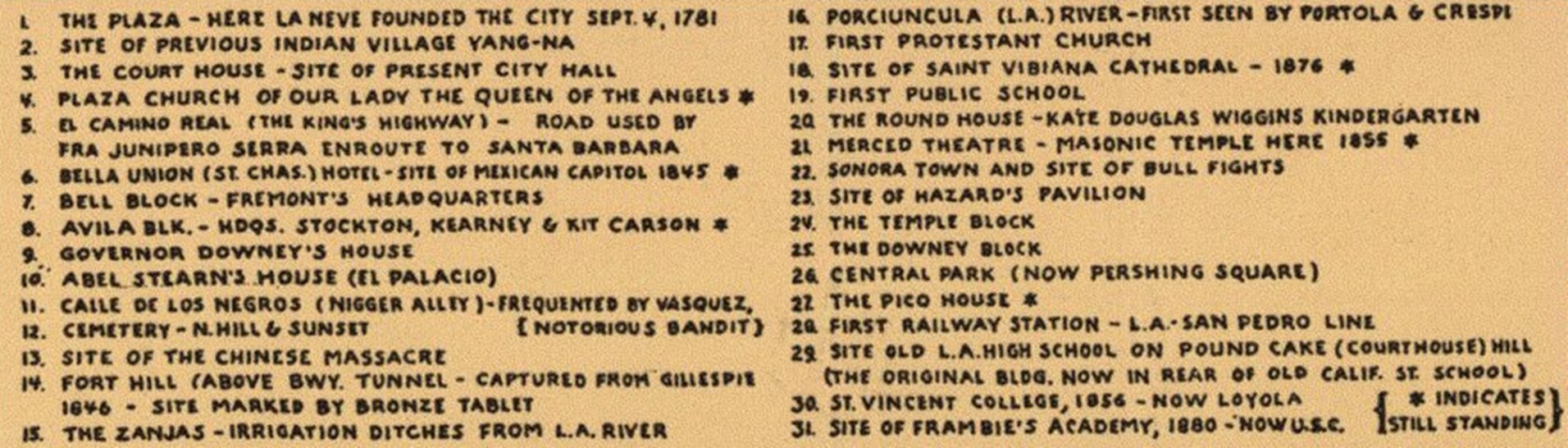 |
|
| (1871)* - Legend for the Los Angeles as it appeared in 1871 map, identifying key buildings, institutions, and landmarks included in the bird's-eye view. |
Historical Notes The legend identifies the principal landmarks of early Los Angeles and serves as a guide to the buildings and institutions that defined the city at that moment. Included are the Old Plaza Church, Pico House, Merced Theater, Masonic Lodge, schools, churches, commercial blocks, and many other locations that formed the backbone of civic life in the young city. The legend also reflects the broader purpose of the Women's University Club project. Created at a time when many nineteenth-century buildings had already disappeared, the map was intended to preserve a visual record of early Los Angeles for future generations. More than ninety years later, it remains an important reference tool for historians, researchers, and anyone interested in the city's formative years. |
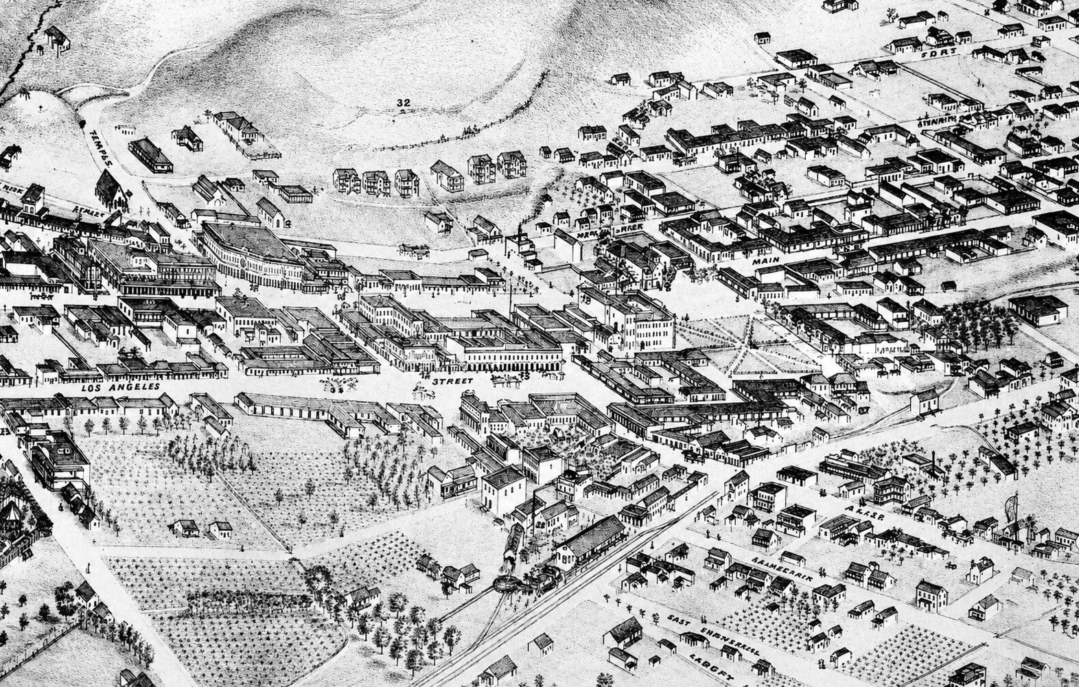
Closer Look at the North End of Los Angeles
 |
|
| (1871)* - Closer detail view of the north end of Los Angeles as it appeared in 1871, showing the Plaza district and surrounding streets from the Women's University Club map. |
Historical Notes This enlarged view brings the Plaza district into sharper focus and reveals the density of development that had accumulated around the historic center of Los Angeles by the early 1870s. The recently completed Pico House is visible facing Main Street at the Plaza, while the Merced Theater and Masonic Lodge stand nearby as symbols of the city's growing commercial and cultural ambitions. The street pattern visible in this detail traces directly to the Spanish colonial town planning established at the founding of the pueblo in 1781. Unlike the rigid north-south grids adopted by many American cities, Los Angeles retained a distinctive diagonal orientation prescribed by the Laws of the Indies. More than two centuries later, this early planning decision remains visible in the street pattern of downtown Los Angeles. |
Los Angeles in the Early 1870s
 |
|
| (ca. 1871)* - Photograph of a lithograph depicting Los Angeles with the Plaza and Pico House visible at center right. The view shows the compact urban core of the city surrounded by extensive orchards, farmland, and open land in the foreground, with the mountains visible in the background. |
Historical Notes This lithograph, likely drawn by Augustus Koch and printed by Britton and Rey, provides a contemporary view of Los Angeles in 1871 that complements the reconstructed bird's-eye map produced nearly six decades later. The image captures with remarkable clarity the agricultural character of the landscape surrounding the city during this period. Orchards, vineyards, and open farmland extended outward from the compact downtown core in nearly every direction, a reminder that Los Angeles remained as much a farming community as an urban one. The Plaza and the newly completed Pico House are visible at center right, anchoring the historic heart of the city. At the time this lithograph was created, Los Angeles had a population of approximately 5,700 to 6,000 residents. Although small by national standards, it was the largest community in Southern California and was becoming increasingly diverse as new settlers, immigrants, and businesses arrived. The city remained concentrated around the Plaza and a handful of commercial streets, while agriculture continued to dominate the surrounding landscape. Within a decade, the arrival of the railroad and the great land boom of the 1880s would dramatically accelerate growth, transforming Los Angeles from a compact frontier town into one of the fastest-growing cities in the American West. |
* * * * * |
The Plaza District Evolves (1873-1875) |
By the early 1870s, the area surrounding the Los Angeles Plaza had undergone a series of physical and commercial transformations that marked a clear departure from its pueblo-era appearance. The most visible change was the Plaza itself. For nearly a century, the public square at the center of Los Angeles had retained its original rectangular form, consistent with the Spanish colonial town planning established at the city's founding in 1781. That changed around 1870, when the newly formed Los Angeles City Water Company, as part of its franchise agreement with the city, removed the old Dryden reservoir, installed a fountain, landscaped the grounds, and redesigned the Plaza into the circular park seen in the photographs that follow.The transformation of the Plaza was part of a broader wave of modernization reshaping the district during this period. Gas lighting had expanded significantly since its introduction in 1867, and the commercial corridor along Main Street had grown more substantial with the addition of the Pico House, the Merced Theater, and the Masonic Lodge. The images and documents presented here capture the Plaza district at a pivotal moment when the old pueblo was giving way to the first unmistakable signs of a modern American city. Together they document changes in public space, utilities, commerce, and land ownership that would shape the future growth of Los Angeles. |
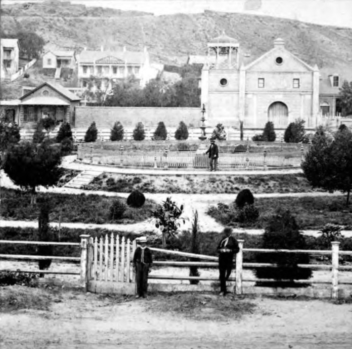
The Plaza Reimagined
 |
|
| (1875)* - View across the Los Angeles Plaza, with three people posing for the photograph. The Old Plaza Church and the Cape House Restaurant are visible in the background, and Fort Moore Hill can be seen in the far background. The Plaza has been redesigned into its circular landscaped form, a significant change from the rectangular public square visible in earlier views. |
Historical Notes This photograph documents one of the most significant physical changes in the history of the Los Angeles Plaza. The circular, landscaped configuration visible here replaced the original rectangular public square that had characterized the Plaza since the pueblo's founding in 1781. The transformation was completed around 1870 as part of the franchise agreement between the City of Los Angeles and the newly formed Los Angeles City Water Company. In exchange for a thirty-year franchise to operate the city's water distribution system, the company agreed to remove the old Dryden brick reservoir that had stood at the center of the Plaza since 1858, install a fountain in its place, and landscape the grounds as a public park. The Cape House Restaurant visible in the background reflects the growing commercial activity that increasingly surrounded the Plaza during this period. Fort Moore Hill, visible in the distance, would remain a prominent landmark until the twentieth century, when grading associated with Civic Center expansion permanently altered the hill. Comparing this view to photographs taken only a few years earlier reveals how dramatically the Plaza had changed, from a dusty public square dominated by a utilitarian water reservoir to an inviting landscaped park at the center of a modernizing city. Click HERE to see more in Water in Early Los Angeles. |
Main Street and the Growing Commercial District
.jpg) |
|
| (ca. 1873)* - View of Main Street and the Plaza showing the Pico House, the Merced Theater, and the Masonic Lodge. The gas works tanks are visible in the foreground. The gas tanks were built in 1867, the Pico House and Merced Theater in 1870, and the Masonic Lodge in 1865. |
Historical Notes This view along Main Street captures the commercial heart of Los Angeles in the early 1870s, when the district surrounding the Plaza was taking on a more substantial urban character. The Pico House, completed in 1870, anchors the scene, while the Merced Theater and Masonic Lodge extend the line of significant brick buildings along the street. Together these structures represented a level of architectural permanence and civic ambition that the city had not previously achieved, signaling that Los Angeles was beginning to see itself as something more than a frontier pueblo. The gas tanks visible in the foreground belonged to the Los Angeles Gas Company, the forerunner of Southern California Gas Company, which installed the city's first street lighting system in 1867 consisting of forty-three gas lamps along Main Street. By 1873, that number had grown to 136 gas lamps providing outdoor night lighting throughout the city. The gas plant, including its two large storage tanks, stood just south of the Old Plaza Church across from the Plaza itself. Gas lighting would remain the city's primary source of outdoor illumination until 1882, when electricity was introduced and Los Angeles took another important step toward modernization. Things would change in 1882 when electricity was introduced. Click HERE to see more in Early Los Angeles Streetlights. |
Mapping a City in Transition
.gif) |
|
| (1873)* - The Ruxton Survey of the Central Pueblo, dated March 12, 1873. This detailed survey map shows the Plaza area and surrounding streets, identifying early buildings, property owners, the alignment of the Zanja Madre, and streets in use at the time. The Plaza itself is shown in its pre-landscaping rectangular form, as the survey appears to have been drawn from earlier source material predating the circa 1870 improvements. |
Historical Notes This detailed property survey, formally titled Map of the Old Portion of the City Surrounding the Plaza and drawn by surveyor A. G. Ruxton on March 12, 1873, is one of the most detailed documentary records of the historic Plaza district produced during the nineteenth century. Held today in the Library of Congress Geography and Map Division, the survey identifies individual property owners, building locations, street alignments, and the course of the Zanja Madre, the original irrigation ditch that carried water from the Los Angeles River to the pueblo since its founding in 1781. The Zanja Madre, whose name translates as "Mother Ditch," remained a vital part of the city's water system at the time this survey was prepared, though it would eventually be enclosed and abandoned as Los Angeles outgrew its original water infrastructure. The survey is notable for identifying a large number of women among the property owners of the Plaza district, offering a glimpse into patterns of land ownership in early Los Angeles that are rarely documented elsewhere. Their presence reflects property rights available to women under Spanish and Mexican legal traditions, rights that often exceeded those available to women in many parts of the United States during the same period. The survey also records the location of the first gas plant, the Old Plaza Church, and many of the adobe structures that still lined the streets surrounding the Plaza. Readers will notice that the Plaza itself is depicted in its earlier rectangular form rather than the circular landscaped configuration completed around 1870. Like the 1929 Women's University Club map shown in the previous section, the survey appears to rely on earlier source material for the Plaza's layout. Despite this detail, the survey remains an invaluable record of the historic core of Los Angeles at a moment when the old pueblo was being systematically documented even as it was being transformed. Click HERE to see more in Early Views of the Los Angeles Plaza. |
* * * * * |
Civic Los Angeles: City Hall, the Jail, and Court House Hill |
In the years following California statehood in 1850, the young city of Los Angeles struggled to establish the basic institutions of civic order. The streets were unpaved, the population was small and transient, and the structures that served as city hall, courthouse, and jail were modest at best. The photographs in this section document that early civic landscape, centered on the blocks of Spring Street between Temple and First streets, where a converted adobe residence served simultaneously as the seat of city government and the hub of a justice system that was often overwhelmed.During the 1850s, Los Angeles gained a reputation as one of the most violent communities in the American West, with violence in the streets, banditry on the roads, and a jail that vigilante mobs repeatedly breached to carry out their own executions. The city's first public buildings were expressions not of civic pride but of urgent necessity, and their histories are inseparable from one of the most turbulent chapters in Los Angeles history.Together, these structures formed the center of civic authority in early Los Angeles. Before the construction of the courthouses, city halls, and government buildings that would later dominate downtown, the city's public affairs were conducted from a handful of modest adobe and brick buildings clustered along Spring Street beneath Court House Hill. |
 |
|
| (ca. 1869)* – View looking southeast from the slope of Poundcake Hill, showing a man with a rifle standing on New High Street (soon to be renamed Spring Street). At center right is the intersection of New High and Temple streets. The two-story brick building at center is the Allen Block, located at the southwest corner of Spring and Temple streets. The Clocktower Market and Courthouse, built by Jonathan Temple in 1859, is visible behind it. |
Historical Notes The armed man in the foreground is a reminder that carrying a rifle or pistol was commonplace in Los Angeles during the 1850s. Historians generally regard Los Angeles as one of the most violent communities in the United States during this period, with frequent shootings, organized banditry, and a justice system that often struggled to maintain order. Many residents routinely went armed, while law enforcement agencies remained small and underfunded. The prominent building visible behind the Allen Block is the Clocktower Market and Courthouse, built by Jonathan Temple in 1859. Temple modeled the structure after Boston's famous Faneuil Hall, envisioning a public market on the ground floor with a theater above. When the commercial venture failed to meet expectations, the city and county leased portions of the building for governmental use. Its distinctive clock tower, rising approximately sixty-five feet above the roofline, quickly became one of the most recognizable landmarks in Los Angeles, although the clock itself was reportedly not always reliable. New High Street, where this photograph was taken, was renamed Spring Street during this same period. The Allen Block at the southwest corner of Spring and Temple streets was among several brick commercial buildings that helped establish this intersection as part of the city's emerging civic and commercial center. Together, these structures reflected the gradual transition of Los Angeles from a frontier pueblo into a more organized American city. Click HERE to see another view of New High and Temple. |
 |
|
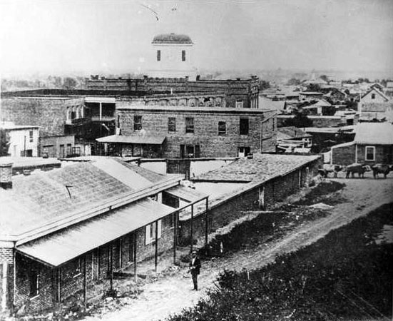
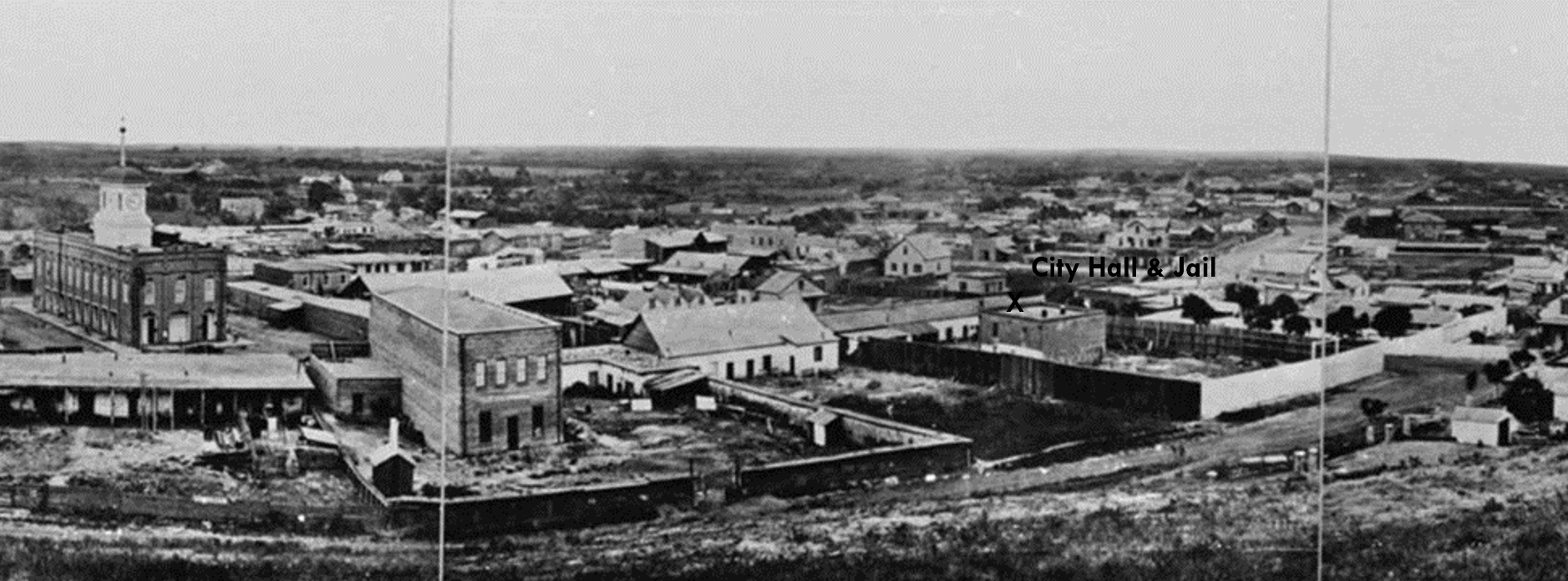
| (1868)* - Composite panoramic view looking southeast showing Los Angeles' first City Hall & Jai at center-right, on the west side of Spring Street between Temple and First streets. The Clocktower Market and Courthouse, built by Jonathan Temple in 1859, stands at left. Spring Street runs between the two buildings, while the jail yard and two-story jail structure are visible behind the City Hall adobe. |
Historical Notes The building at center-right is the Rocha Adobe, which served as Los Angeles' first City Hall from 1853 until the late 1880s. The structure was built around 1820 by Antonio José Rocha, a native of Lisbon, Portugal, who arrived in California in 1815 and eventually settled in Los Angeles. In 1853, the city and county acquired the adobe from Jonathan Temple and adapted it for municipal use. The building occupied the west side of Spring Street between Temple Street and Jail Street, the latter later renamed Franklin Street. Today, the site lies within the area occupied by Los Angeles City Hall. In 1854, a two-story jail was constructed in the large yard behind the adobe. The ground floor, built of adobe, served as the city jail, while the brick upper story housed county prisoners. The high fence surrounding the jail yard was erected not to keep prisoners from escaping, but to protect them from vigilante mobs. Despite these efforts, the jail was breached on multiple occasions during the 1850s and 1860s by groups who removed prisoners and carried out lynchings. The gallows used for legal executions also stood within the jail yard. Visible at left is the Clocktower Market and Courthouse, also seen in the previous image. Spring Street runs between the two buildings, making this panoramic view one of the few surviving images that captures both of Los Angeles' principal civic structures in a single frame. Together they formed the center of government, law enforcement, and judicial authority in the young city during a period of rapid growth and profound change. Click HERE to see more views of Los Angeles' First City Hall and Jail. |
* * * * * |
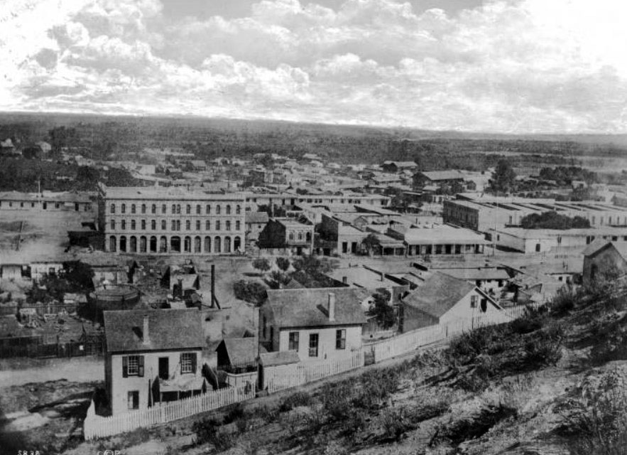
Panoramic Views of a Growing Los Angeles |
By the late 1860s, Los Angeles was beginning to outgrow its origins as a small pueblo centered on the Plaza. New commercial buildings were appearing along Spring and Main streets, transportation connections were improving, and the city's population was increasing at an unprecedented rate. While many surviving photographs from this period focus on individual buildings or street scenes, panoramic views provide something even more valuable: a broad perspective of how the entire community was organized and how rapidly it was changing.The remarkable images in this section were photographed from Poundcake Hill, one of the highest points overlooking downtown Los Angeles. Before it became the site of Los Angeles High School in 1873 and later the County Courthouse, the hill offered photographers an unobstructed view across the city. From this vantage point, many of Los Angeles' most important landmarks could be seen, including the Plaza, Temple Block, Downey Block, St. Athanasius Episcopal Church, the Clocktower Market and Courthouse, and dozens of homes, businesses, and public buildings that defined the city during the years immediately preceding its first major boom.Together, these panoramas provide one of the most complete visual records of Los Angeles during the transition from frontier town to emerging city. They allow modern viewers to see the community much as residents of the late nineteenth century would have seen it, before railroads, large-scale development, and explosive population growth transformed Southern California forever. |
.jpg) |
|
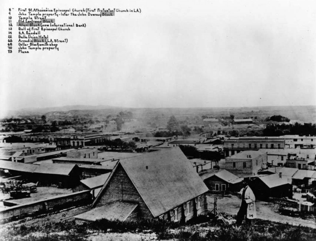
| (ca. 1869)* - Left panel of Stephen A. Rendall's panoramic photograph of downtown Los Angeles, looking southeast from the slope of Poundcake Hill. Each building in the view is individually numbered and identified in an annotated key along the top of the image. The photographer himself appears in the photograph as figure No. 14, standing on the hillside above the city. |
Historical Notes Rendall photographed this panorama from Poundcake Hill, a prominent rise overlooking downtown Los Angeles that later became the site of Los Angeles High School in 1873 and the County Courthouse in 1891. At the time, the hill remained largely undeveloped, providing an ideal vantage point from which to record the growing city below. The panorama captures Los Angeles at a pivotal moment in its history. Although still compact enough to be photographed in a single sweeping view, the city was beginning to expand beyond its original Plaza-centered settlement. New commercial buildings, churches, schools, and public institutions were appearing throughout downtown, reflecting a community entering a period of sustained growth. The population of Los Angeles stood at approximately 5,600 residents in 1870. Within three decades, that figure would exceed 100,000. The modest scale of the city visible in this panorama provides a striking contrast to the metropolis that would emerge by the turn of the twentieth century. |
 |
|
| (ca. 1869)* – Closer view from the same panorama showing photographer Stephen A. Rendall standing on the hillside above the city. St. Athanasius Episcopal Church, the first continuing Protestant congregation in Southern California, is visible directly below him at center, identified as property No. 8 in Rendall's key. The Griffin and Tomlinson Lumber Yard is at lower left. New High Street (later Spring Street) runs horizontally across the foreground. |
Historical Notes St. Athanasius Episcopal Church, the small brick building directly below Rendall in this view, holds a significant place in the religious history of Los Angeles. The congregation was formally organized on Christmas Day 1864, making it the oldest continuing Protestant house of worship in Southern California. Its first building, a red-brick structure at the corner of Temple and New High streets, had originally been started by Presbyterians who ran out of funds before completing it. The Episcopalians took over the unfinished structure, completed it, and named the congregation after Athanasius, the fourth-century bishop of Alexandria. The Rev. Elias Birdsall led the congregation's first services in December 1864 in the Odd Fellows Hall, and the church building at Temple and New High was acquired in 1865. The building stood just northwest of where Los Angeles City Hall now stands. St. Athanasius remains active today as part of the Episcopal Diocese of Los Angeles. |
 |
|
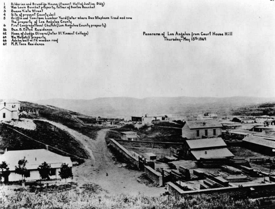
| (1869)* – Detail from Rendall's panorama, looking southeast from Court House Hill on May 13, 1869. The Griffin and Tomlinson Lumber Yard (No. 5) dominates the right foreground, with stacks of processed lumber visible along the street. Other properties identified in Rendall's annotated key include the Wolfskill property (No. 64), the First Congregational Church (No. 6), the Ben B. Eaton Residence (No. 56), and several private residences on the hillside to the left. |
Historical Notes The Griffin and Tomlinson Lumber Yard, visible in the foreground of this detail view, occupied a prominent corner lot along New High Street (soon renamed Spring Street) in 1869. Lumber yards were essential enterprises in a city undergoing rapid construction, supplying the wood framing, siding, and finish materials needed for the new brick and frame commercial buildings then rising throughout downtown. In the years following this photograph, this corner became associated with a darker chapter of Los Angeles history: the property near this intersection was the site of multiple lynchings during the 1860s and 1870s, including events connected to the Chinese Massacre of 1871. The prominent building at center is the Clocktower Market and Courthouse, built by Jonathan Temple in 1859 and by 1869 serving as the county courthouse. Its distinctive tower, with the clock faces oriented north and south, was one of the most recognizable features of the downtown skyline at the time this photograph was taken. |
.jpg) |
|
| (ca. 1869)* - Right panel of a panoramic photograph/sketch of downtown Los Angeles looking southeast from Bunker Hill with each property annotated and listed at top. The location of the camera was at the top of a hill called ‘Poundcake Hill’ the future site of Los Angeles High School (1873) and the 2nd L.A. County Court House (1891). |
Historical Notes Taken together, the two panels form one of the most important visual records of nineteenth century Los Angeles. Few surviving photographs provide such a comprehensive view of the city's buildings, streets, businesses, and surrounding landscape during this period. The importance of Rendall's panorama was recognized decades later. Writing in 1911, W. S. Broke noted in Outpost: Preserving Historical Data that much of the photographic record of Los Angeles before the 1880s had already disappeared. He described Rendall's bird's-eye view as "a remarkable photograph in every way" and praised its value as a record of the city during the 1860s and 1870s. Today, the panorama remains an indispensable resource for historians, providing an extraordinary level of detail about Los Angeles before large-scale urban development altered the city's landscape. |
 |
|
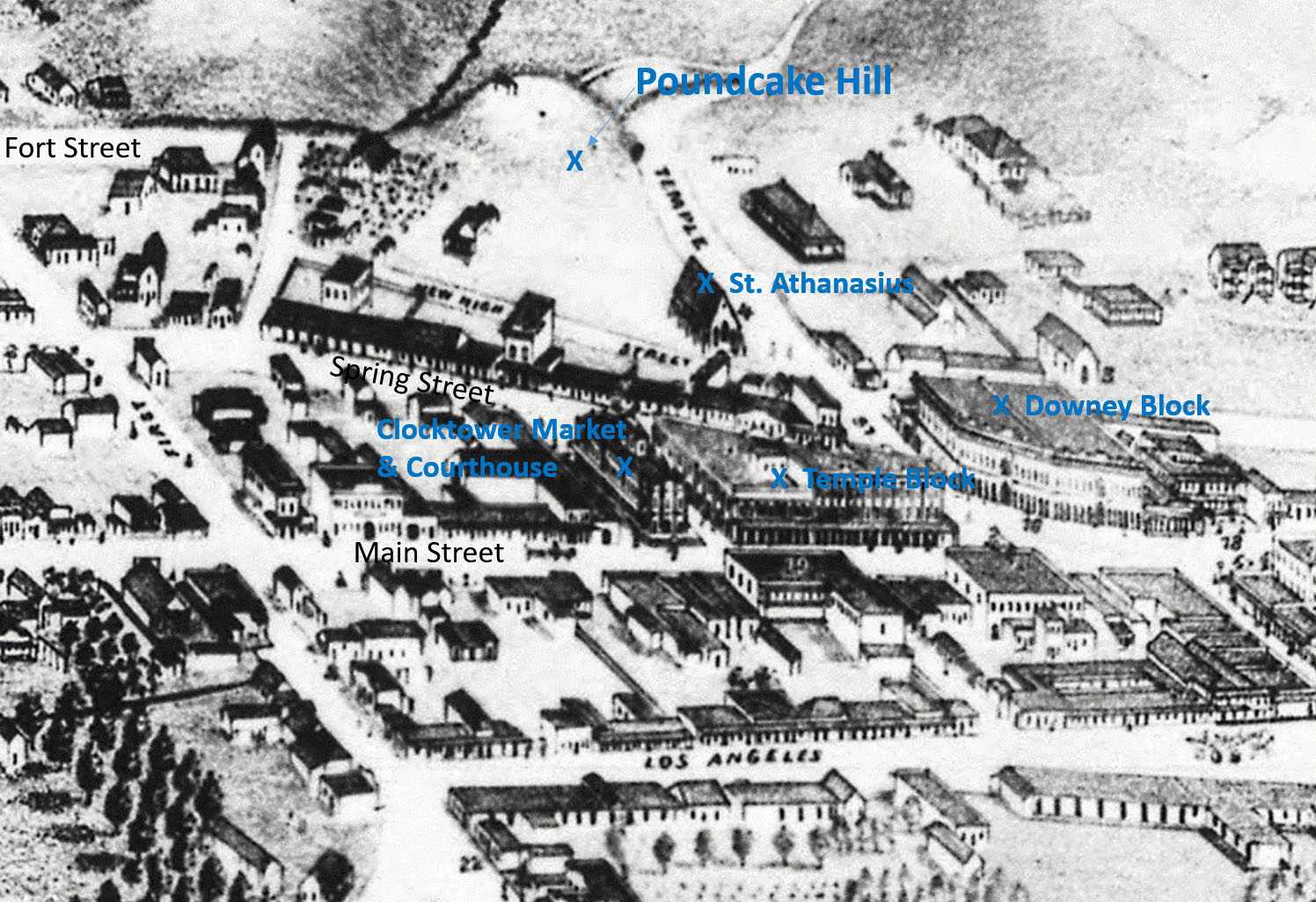
| (1871)* - Photograph of a lithograph showing Los Angeles as it appeared in 1871 with Poundcake Hill at top. Also seen and highlighted are: St. Athanasius, Downey Block, Temple Block and the Clocktower Market/Courthouse. |
Historical Notes This lithographic view serves as an ideal companion to Rendall's panorama, depicting many of the same landmarks while helping viewers understand their relationship to one another within the growing city. The Downey Block, visible near the center of the image, was completed in 1871 by former California Governor John G. Downey and quickly became one of the most prominent commercial buildings in Los Angeles. Nearby stand Temple Block, St. Athanasius Church, and the Clocktower Market and Courthouse, all important landmarks during the city's formative years. Poundcake Hill occupies the upper left portion of the scene. Within two years, Los Angeles High School—the first public high school in Southern California—would be built on its summit. Fort Street, visible nearby, would eventually be extended and renamed Broadway in 1890, becoming one of the city's principal commercial and civic corridors. Together, the lithograph and Rendall's panorama capture Los Angeles at the threshold of dramatic change, preserving a city that would soon be transformed by growth, modernization, and the arrival of a new century. |
* * * * * |
Streets of the Growing City |
While the Plaza remained the symbolic center of Los Angeles during the nineteenth century, the city's daily life increasingly unfolded along the streets that radiated outward from it. Roads that had once served a small pueblo began evolving into commercial corridors lined with stores, hotels, schools, offices, and transportation routes. As the population grew, new institutions emerged to support the needs of a community that was becoming larger, more diverse, and more connected to the surrounding region.The images in this section trace that transformation through some of Los Angeles' most important early streets, including Aliso Street, Main Street, Spring Street, and Commercial Street. Together they document the growth of the city's business district, the development of public education, the emergence of banking and commerce, and the gradual replacement of adobe buildings with more substantial brick structures. These views reveal how a compact settlement centered on the Plaza expanded into a functioning American city, with streets that served not only as transportation routes but also as the economic and civic backbone of the growing community.Many of the buildings, businesses, and streetscapes shown here have long since disappeared beneath redevelopment, freeways, and modern construction. Yet these photographs preserve a remarkable record of the places where Los Angeles first learned to operate as a city, where merchants conducted business, students attended school, newspapers were printed, banks were founded, and commercial ambitions began to reshape the future of Southern California. |
Aliso and Alameda Streets |
Aliso Street is one of downtown Los Angeles’ oldest thoroughfares, and its history reaches far deeper than the roadway itself. Named for a legendary sycamore tree that stood near the Los Angeles River for nearly four centuries, the street once served as one of the principal routes into the Pueblo of Los Angeles and occupied an area long associated with the Tongva village of Yangna. The views below capture the transformation of the corridor from a dusty nineteenth century roadway lined with adobes, vineyards, and open land into a landscape reshaped by freeways, grading projects, and Civic Center redevelopment. |
_cleanup.jpeg) |
|
| (ca. 1860)* - Looking west on Aliso Street from Alameda Street, with Fort Moore Hill visible in the background at upper right. At the time, Aliso Street served as one of the principal thoroughfares leading into the Pueblo of Los Angeles. Today, the 101 Freeway runs along and beneath the right side of this historic view. Historic image lightly enhanced for clarity and detail. Original file photo HERE. |
Historical Notes Aliso Street takes its name from one of the most legendary trees in Los Angeles history. El Aliso, a massive sycamore estimated to have sprouted in the late fifteenth century around the time Columbus arrived in the Americas, stood near the Los Angeles River for nearly four centuries. Rising nearly sixty feet high with an enormous spreading canopy, the tree became an important landmark and gathering place for generations of Native inhabitants, settlers, and travelers. The Tongva people regarded the surrounding area as part of Yangna, one of the largest indigenous settlements in the Los Angeles Basin and a center of community life long before the arrival of the Spanish. By the early nineteenth century, the land surrounding El Aliso had become closely associated with French vintner Jean Louis Vignes, whose vineyard and winery occupied much of the nearby area. So closely was he tied to the tree that locals nicknamed him “Don Luis del Aliso.” As Los Angeles expanded during the American era, Aliso Street evolved into one of the city’s principal transportation corridors connecting the growing pueblo with river crossings, ranch lands, and communities to the east. By 1860, the population of Los Angeles had grown to 4,385, nearly three times the 1,610 recorded in the 1850 census, although historians widely regard that earlier figure as a significant undercount. Despite that growth, much of the landscape still retained its rural pueblo era appearance, with open land, modest structures, vineyards, and unpaved roads still dominating the eastern edge of the city. |
 |
|
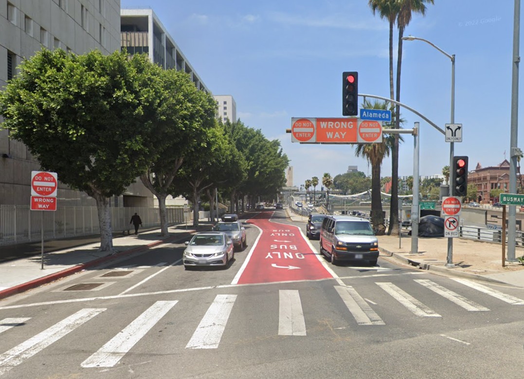
| (2022)* - Looking west on Aliso Street at Alameda Street in downtown Los Angeles, with the Hollywood Freeway running parallel on the right. Little remains of the nineteenth century landscape seen in the earlier photograph, as decades of freeway construction and urban redevelopment dramatically reshaped the area surrounding the historic roadway. |
Historical Notes By the late nineteenth century, the landscape surrounding Aliso Street had changed dramatically. The old Vignes winery property eventually became the Philadelphia Brewery, and continued industrial expansion gradually consumed the area around El Aliso. In 1889, brewery owners removed most of the tree’s massive branches and enclosed portions of the ancient trunk within adjoining brick structures as development pressed tightly around it. By the early 1890s, the giant sycamore, estimated to be roughly four hundred years old, was cut down to accommodate further brewery expansion. Its destruction marked the disappearance of one of Los Angeles’ oldest and most historically significant natural landmarks. The street bearing its name became one of the few surviving reminders of the legendary tree that once stood near the riverbank. The transformation accelerated during the twentieth century. In the 1950s, large portions of Aliso Street through downtown were excavated or removed during construction of the Hollywood Freeway as part of a broader wave of urban renewal projects that reshaped central Los Angeles. Entire residential and commercial districts disappeared beneath freeway infrastructure, Civic Center expansion, and new government buildings. Today, Aliso Street survives primarily as a frontage road alongside the 101 Freeway, a stark contrast to its former role as one of the principal approaches into early Los Angeles. |
Then and Now
 |
|
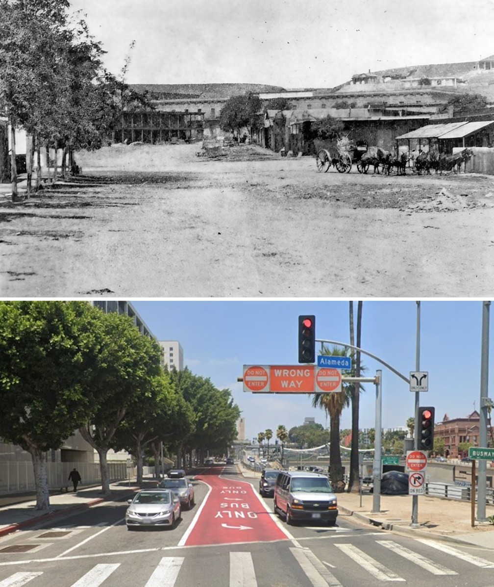
| (1860 vs. 2022)* – A Then and Now comparison of Aliso Street looking west from Alameda Street in downtown Los Angeles. Once one of the principal gateways into the Pueblo, Aliso Street was dramatically transformed during the twentieth century by freeway construction, grading projects, and Civic Center redevelopment. Photo comparison by Jack Feldman. |
Historical Notes This comparison illustrates one of the most dramatic physical transformations in the history of downtown Los Angeles. In 1860, Aliso Street was a dusty but important corridor connecting the pueblo with the Los Angeles River and surrounding communities. Adobe structures, vineyards, wagon routes, and open land still characterized much of the landscape, while Fort Moore Hill rose prominently in the background overlooking the growing city. A century later, construction of the Hollywood Freeway had fundamentally reshaped the entire district. Fort Moore Hill, visible at upper right in the 1860 image, was partially excavated beginning in 1949 to accommodate the freeway alignment, while much of old Aliso Street disappeared altogether beneath roadway construction and Civic Center redevelopment. In 2019, the City of Los Angeles installed a bronze plaque near Commercial and Vignes streets marking the approximate location of the legendary sycamore that gave both the street and surrounding district their historic identity. Click HERE to see more Early Views of Aliso Street. |
* * * * * |
Main Street: The Center of Early Los Angeles |
Main Street is one of Los Angeles' oldest thoroughfares, its origins tracing back to the founding of the pueblo in 1781. Known during the Spanish and Mexican eras as Calle Principal, it extended southward from the Plaza and served as one of the community's principal routes through the growing settlement. As Los Angeles evolved from a small adobe pueblo into an American city, Main Street evolved with it, becoming home to many of the city's earliest hotels, banks, stores, and public gathering places.The photographs and images in this section span roughly fifteen years, from 1868 to 1883, a period during which Main Street underwent remarkable change. Together they document the growth of the city's business district, the arrival of new hotels and financial institutions, the introduction of electric street lighting, and the public celebrations that brought residents together along one of Los Angeles' most important streets. |
Early Views of Main Street |
The two photographs below, both taken in 1868, are among the earliest known views of Main Street in Los Angeles. They capture Los Angeles at a time when much of the city's commercial activity remained concentrated around the Plaza and the intersection of Main, Spring, and Temple streets. Unpaved roads, covered wooden sidewalks, scattered commercial buildings, and open land beyond the city center reveal a community that was still modest in scale but already beginning to expand. ogether, these photographs show Main Street during a transitional period, when Los Angeles was emerging from its frontier past and laying the foundations for the growth that would follow in the decades ahead. |
.jpg) |
|
| (1868)* - View along Main Street from Temple Block, showing a row of one- and two-story commercial buildings lining the east side of the unpaved street. Covered wooden walkways extend along the storefronts while a horse-drawn wagon occupies the foreground. The scattered buildings and open land visible in the distance reflect the still modest scale of Los Angeles at the time. |
Historical Notes Main Street began as Calle Principal, one of the original roads extending outward from the Plaza when Los Angeles was founded in 1781. The street appeared on Lieutenant Edward O.C. Ord’s landmark 1849 survey map of Los Angeles, which established much of the city’s early American era street grid. During the nineteenth century, Spanish street names were gradually replaced with English equivalents, and Calle Principal eventually became Main Street. By the time this photograph was taken in 1868, the section of Main Street seen here had already become the commercial center of Los Angeles. The view was taken from Temple Block, a prominent business complex developed by Jonathan Temple, a Massachusetts-born merchant who settled in Mexican Los Angeles in 1827. Temple operated what is widely regarded as the city’s first general store and later helped establish the important commercial district surrounding Main, Spring, and Temple streets. The triangular intersection formed by Main, Spring, and Temple streets became one of the busiest and most influential corners in nineteenth century Los Angeles. Over time, the district developed into the center of the city’s legal, financial, political, and commercial life. |
.jpg) |
|
| (1868)* - View looking east from the top of the United States Hotel at Main and Requena streets. Covered storefronts line Main Street in the foreground, while the dense line of trees in the middle distance marks the course of the Los Angeles River. The San Gabriel Mountains rise along the horizon beyond the growing city. |
Historical Notes The United States Hotel, from which this photograph was taken, was constructed in 1861 and 1862 at the southeast corner of Main and Requena streets. At the time, it was one of only a few major hotels operating in Los Angeles and served travelers, merchants, newcomers, and businessmen arriving in the rapidly growing city. Located directly across Main Street from Temple Block, the hotel occupied a prominent position within the city’s developing commercial district. Requena Street was named after Manuel Requena, one of the most important civic leaders in nineteenth century Los Angeles. Born in Yucatán, Mexico, in 1802, Requena arrived in Los Angeles during the Mexican era and later served the city through both Mexican and American rule. During the final years of Mexican rule he served as alcalde, the equivalent of mayor, and in 1856 briefly served as acting mayor under American administration. He also helped establish the city’s first public school at Second and Spring streets and became a member of the first Los Angeles County Board of Supervisors in 1852. The tree-lined corridor visible in the distance also serves as a reminder of how closely tied early Los Angeles remained to the Los Angeles River. Before channelization and modern flood control projects transformed the river during the twentieth century, its shifting course, seasonal flooding, and surrounding vegetation strongly influenced both the physical layout and daily life of the growing city. |
* * * * * |
Main Street Becomes a Business Center |
By 1870, Main Street had begun its transformation from a frontier road into a recognizable commercial district. The area north of Temple Street, centered on the 300 block, was already home to some of the city's most prominent institutions, including the Bella Union Hotel, the earliest banks, and the businesses that served a rapidly growing population of merchants, newcomers, and civic leaders.The images in this section show North Main Street during the early 1870s, when construction of the Pico House had just been completed and the Merced Theatre was still under way. Horse-drawn wagons crowded the unpaved street, covered wooden sidewalks lined the storefronts, and the Bella Union Hotel, Los Angeles' oldest hotel, remained the most recognizable landmark on the block. These views capture Main Street at the moment when the city's commercial ambitions were beginning to outpace its modest frontier origins. |
 |
|
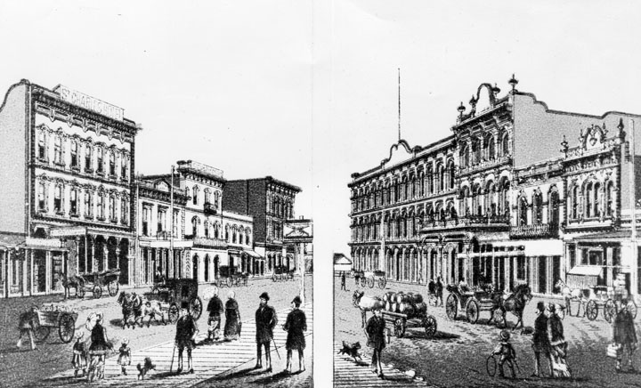
| (1870s)^ - Artist's rendering of North Main Street as it appeared during the 1870s. On the left stands the St. Charles Hotel, originally the Bella Union Hotel. On the right is the rear of Pico's Building, which became the home of Farmers and Merchants Bank in 1871. Next to Pico's Building are the Merced Theatre and Masonic Lodge No. 42. |
Historical Notes Artistic renderings of this kind offer a different form of historical evidence than photographs. Created after the fact to reconstruct how a scene appeared, they reflect both documented period sources and the interpretations of the artist. This rendering shows the east and west sides of North Main Street as they appeared during the 1870s, with the St. Charles Hotel on the left and Pico's Building on the right, flanked by the Merced Theatre and Masonic Lodge No. 42. The buildings shown here occupied one of the most important commercial blocks in nineteenth century Los Angeles. The Merced Theatre, completed in 1870, was the first theater in Los Angeles built specifically for dramatic performances. Nearby stood the Bella Union Hotel, Pico House, Farmers and Merchants Bank, and Masonic Lodge No. 42. Together, these institutions helped establish North Main Street as the center of business, entertainment, finance, and public life during the city's formative years. |
 |
|
| (1871)* - View of North Main Street looking north from Temple Street, with the Downey Block on the northwest corner at left. The Bella Union Hotel is visible at the far right. Horse-drawn wagons crowd the foreground, reflecting the growing activity along this stretch of Main Street. |
Historical Notes This 1871 photograph looks north along Main Street from Temple Street, showing one of the busiest intersections in early Los Angeles. The Downey Block, visible on the northwest corner at left, was developed by John G. Downey, who served as Governor of California from 1860 to 1862 and later co-founded Farmers and Merchants Bank with Isaias W. Hellman. Downey was among the most influential businessmen in nineteenth century Los Angeles, investing heavily in banking, transportation, and real estate. The congestion of horse-drawn wagons visible in the foreground reflects the growing importance of Main Street as a commercial corridor. Deliveries, passenger travel, and the movement of goods all passed through this intersection, making it one of the busiest locations in the city during the 1870s. |
 |
|
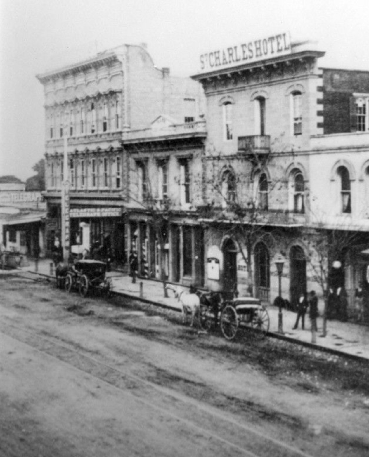
| (ca. 1870)* - View of North Main Street, looking north, photographed after the completion of Pico House in 1870 but before the Merced Theatre was finished. The Bella Union Hotel is visible at right-center. |
Historical Notes This view of North Main Street was taken after completion of the Pico House in 1870 but before construction of the Merced Theatre was finished, placing it within a relatively narrow window that helps date the photograph with unusual precision. Visible in the distance at left, the newly completed Pico House represented the most ambitious hotel project yet undertaken in Los Angeles and quickly became one of the city's most prestigious landmarks. The Bella Union Hotel, visible at right center, had been the city's leading hotel since the early American period and remained one of Los Angeles' most recognizable buildings. Originally established in the 1850s, it served travelers, merchants, stagecoach passengers, and newcomers arriving in Southern California. In the years that followed, the hotel was renamed the Clarendon in 1873 and the St. Charles Hotel in 1875, continuing to play an important role in the city's commercial and social life. Together, the Bella Union Hotel, Pico House, and the businesses along Main Street reflect the rapid commercial growth taking place around the Plaza during the early 1870s. |
* * * * * |
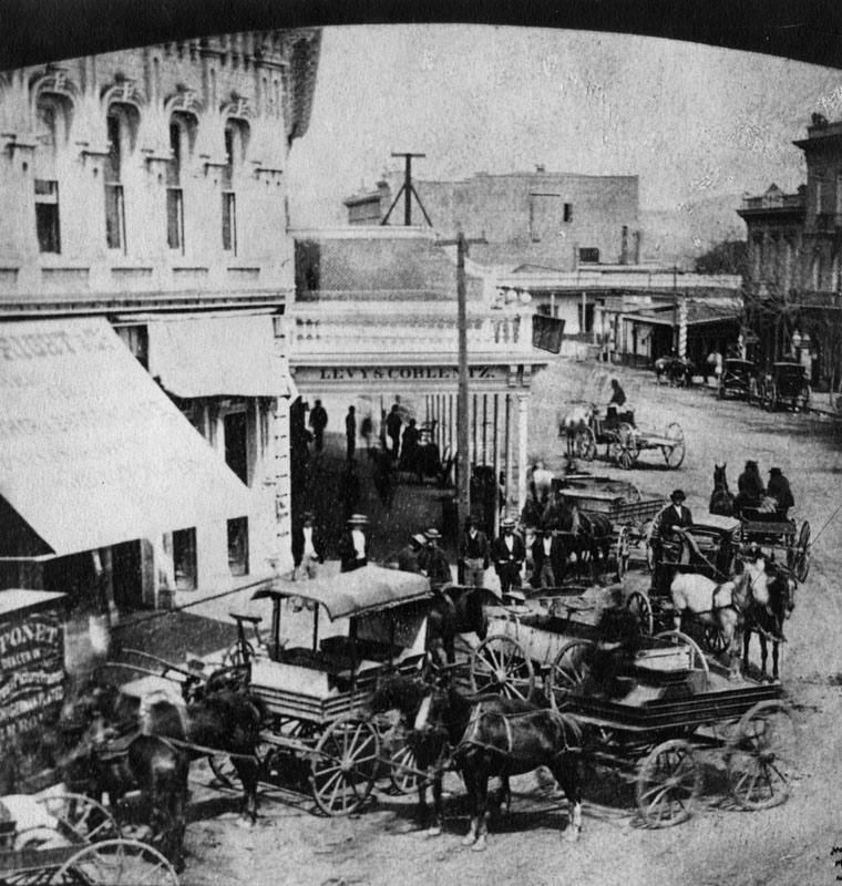
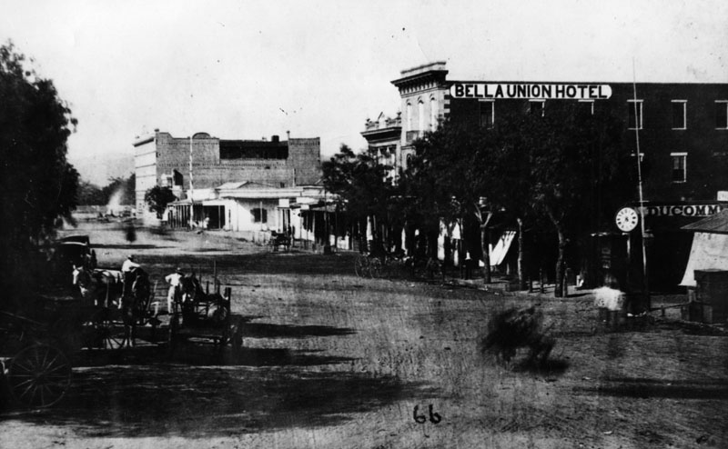
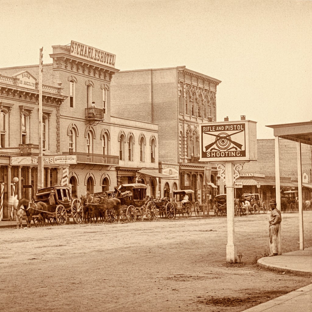
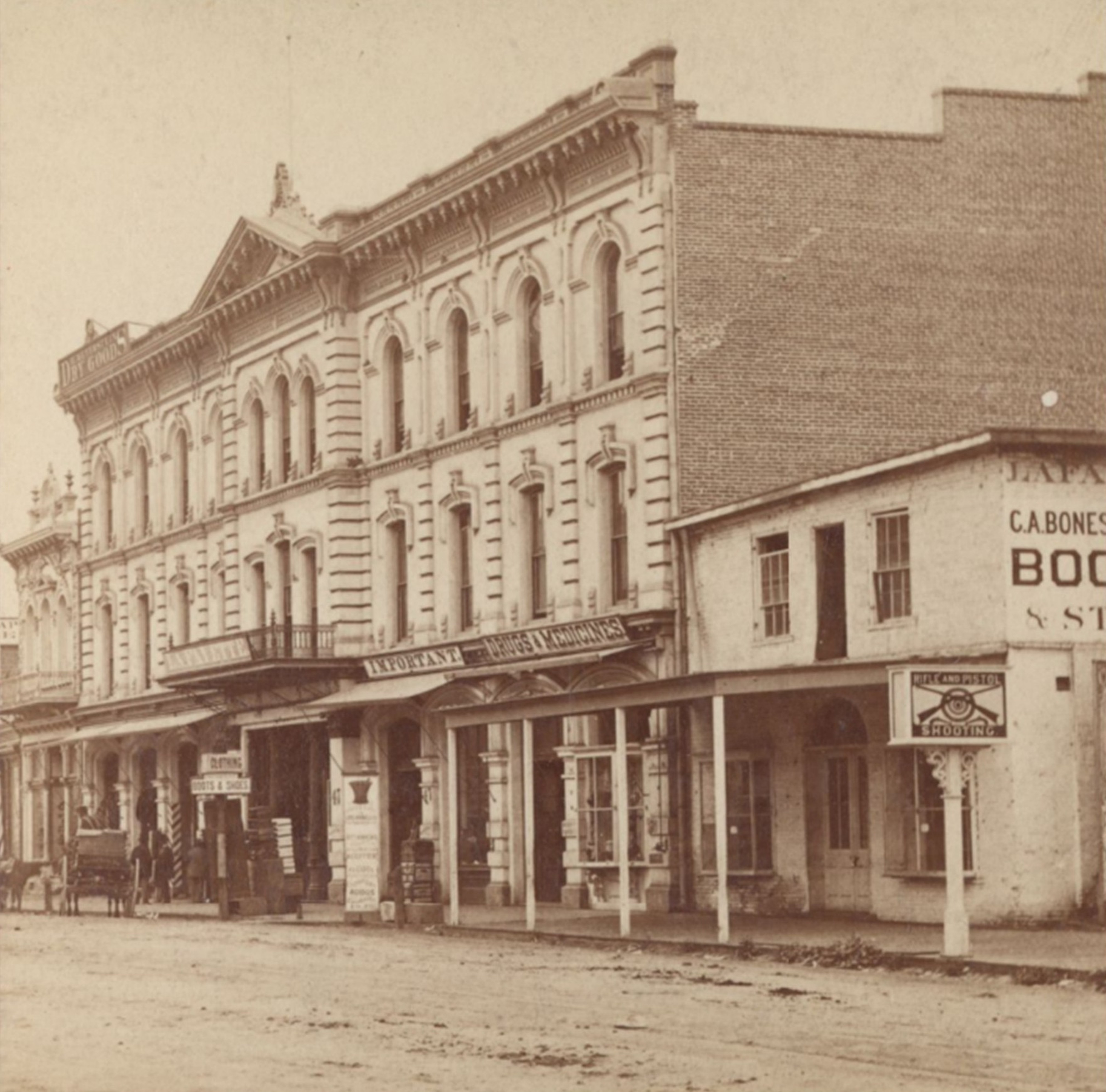
The 300 Block of North Main Street |
The 300 block of North Main Street was one of the most active commercial blocks in nineteenth century Los Angeles. Located between Temple Street and the Plaza, this stretch of Main Street was lined with hotels, banks, storefronts, and small businesses that served travelers, merchants, and residents of the growing city. Few places better illustrate Los Angeles' transition from a frontier town into a modern commercial center.The block's two most prominent landmarks in the 1870s stood directly across from each other. On the east side, the St. Charles Hotel occupied a building with roots dating back to the 1830s, when it served as the Bella Union, one of the city's first American-era hotels. On the west side, the Lafayette Hotel brought Italianate architecture to a street still finding its footing between adobe settlement and commercial center. Together they defined the character of the block during a period when Los Angeles was beginning its transformation from a frontier town into a regional city.By the 1880s, the block was changing rapidly. The Farmers and Merchants Bank, the city's first incorporated bank, occupied the Pico Building just north of the St. Charles. New commercial buildings such as the Baker Block reshaped the skyline, horse-drawn streetcars carried passengers along Main Street, and in 1882 seven towering electric streetlight masts appeared above the city, signaling the arrival of a new era. Together, these developments reflected Los Angeles' emergence as a modern commercial center. Most of the structures seen in these photographs have disappeared. Today, the area is dominated by government and civic buildings, with only a handful of nineteenth century landmarks surviving nearby. |
 |
|
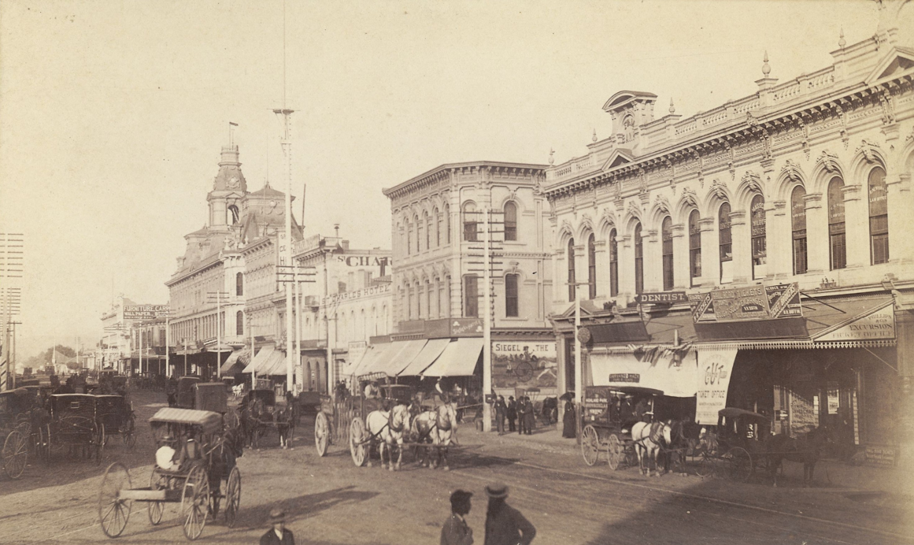
| (1877)* - View looking toward the St. Charles Hotel, originally the Bella Union Hotel, on the east side of Main Street. Horses and buggies are lined up along the street. In the foreground, a sign reading "Rifle and Pistol Shooting" advertises Brulon & Loiseau's Shooting Gallery, a reminder that Los Angeles was still a Western frontier town. |
Historical Notes In the 1870s, Main Street was a place where frontier traditions and growing civic order existed side by side. Los Angeles had a population of nearly 6,000 residents and was rapidly evolving from a frontier town into a more organized commercial center. Hotels, saloons, stores, and small businesses lined the street, serving a diverse mix of travelers, merchants, ranchers, and local residents. At the same time, concerns about public safety and violence were common throughout the American West. Many frontier towns adopted regulations governing firearms and other weapons, while Los Angeles enacted ordinances intended to reduce dangerous activities within city limits, including the discharge of firearms. The shooting gallery sign visible in the foreground reflects this interesting contradiction. Firearms were both a source of public concern and a form of everyday recreation in many Western communities during this period. The St. Charles Hotel itself had deep roots. The building began as an adobe residence in the 1830s and later became the Bella Union Hotel, one of the earliest American-era hotels in Los Angeles. By the 1870s, operating under the St. Charles name, it remained one of the oldest continuously used commercial buildings in the city and a prominent landmark along Main Street. |
 |
|
| (1877)* – View looking toward the Lafayette Hotel on the west side of Main Street, opposite the St. Charles Hotel. The "Rifle and Pistol Shooting" sign at right marks the location of Brulon & Loiseau's Shooting Gallery at street level. |
Historical Notes The Lafayette Hotel was built in the early 1850s and quickly became one of the leading hotels in Los Angeles. Over the years it operated under several names, including the Cosmopolitan and later the St. Elmo, but longtime residents continued to associate it with its original name. The hotel stood just north of Main and Temple and served travelers, merchants, and residents during a period when the city was shifting from an adobe settlement to a more structured commercial center. Architecturally, the Lafayette was among the earliest Italianate-style buildings in Los Angeles. Its tall arched windows, strong vertical lines, evenly spaced pilasters, and deep cornice with decorative brackets brought a sense of permanence and sophistication to a street that was still largely unpaved. These features gave Main Street a more polished appearance that set it apart from the simpler commercial buildings of the previous era. Today the site is part of the Civic Center near City Hall, and none of the original structures remain. |
 |
|
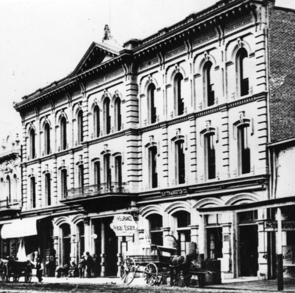
| (ca. 1880)* - Closer view of the Lafayette Hotel on the west side of Main Street. Men gather near the entrance and carriages wait at the curb. Signs for Insurance and Real Estate and the S.P. Transfer Company are visible at street level. |
Historical Notes This view shows the Lafayette Hotel approximately two to three decades after it opened, during the period when it was sometimes known as the Cosmopolitan or the St. Elmo. The activity at street level — men gathered near the entrance, delivery wagons at the curb, and commercial signs filling the ground floor — reflects the steady pace of business that made this section of Main Street a center of daily life in the growing city. The Italianate details of the façade are especially clear at this closer range. The arched windows, iron balcony railings, and bracketed cornice that distinguished the building when it was new remained intact, lending an air of stability to a city that was expanding rapidly around it. Within a few decades, the Lafayette and its neighbors on this block were replaced by public buildings, and the site became part of what is now the Los Angeles Civic Center. |
 |
|
| (1880)* - View looking northeast on Main Street showing the St. Charles Hotel at center, originally the Bella Union Hotel. To the north stands the Farmers and Merchants Bank, housed in the two-story Pico Building. Further north, the three-story Grand Central Hotel, built in 1876, is visible at the left edge. |
Historical Notes The two-story building immediately north of the St. Charles Hotel is the Pico Building, constructed by Pío Pico in 1868, two years before he built the more famous Pico House at the Plaza. In 1871, the building became home to the Farmers and Merchants Bank, the first incorporated bank in Los Angeles, with former California Governor John G. Downey serving as its director. The bank's founders, Isaias W. Hellman and John G. Downey, built an institution that shaped the economic development of the region for decades. Hellman provided the financing that allowed Harrison Gray Otis to purchase the Los Angeles Times in 1882 and later backed Edward Doheny and Charles Canfield when they drilled the first successful oil well in Los Angeles in 1892, helping launch Southern California's petroleum industry. Farmers and Merchants Bank quickly became one of the most influential financial institutions in Southern California. Through the bank, Hellman and Downey helped finance railroads, real estate development, agriculture, publishing, and industry. Its presence on North Main Street reflected the growing economic confidence of a city that was beginning to attract investment from throughout the region. |
 |
|
| (ca. 1882)* – View looking north on Main Street from near Temple Street, showing a busy commercial street scene filled with horse-drawn vehicles and pedestrians. The Ducommun Block stands near the center of the image on the northeast corner of Main and Commercial Streets. The Baker Block tower is visible in the left background, while one of Los Angeles' newly installed electric streetlight masts rises above the surrounding rooftops. |
| Historical Notes
This view captures Main Street during a period of rapid growth, when the area north of Commercial Street had become one of the city's most active commercial districts. The Ducommun Block, occupying the northeast corner of Main and Commercial Streets, was among the most prominent business buildings in the area. Its ornate Italianate façade, with arched windows, decorative cornices, and ground-floor storefronts, reflected the increasingly sophisticated architecture appearing along Main Street during the late nineteenth century. The street itself tells an equally important story. Horse-drawn carriages, delivery wagons, and pedestrians fill the unpaved roadway, while awnings shade the storefronts and signs advertise a variety of businesses serving the growing city. The Baker Block tower visible in the distance, the St. Charles Hotel farther north along Main Street, and the electric streetlight mast rising above the rooftops reveal a city in transition, still retaining many characteristics of a frontier town while steadily developing into the commercial center of Southern California. |
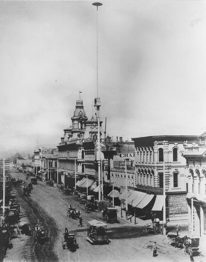 |
|
| (ca. 1887)* - View looking toward the Baker Block on the east side of Main Street, north of Commercial Street. One of the seven 150-foot electric streetlight masts first installed in Los Angeles in 1882 stands in the foreground. A worker can be seen on a platform partway up the mast. |
Historical Notes In 1882, contractor C. L. Howland erected seven arc-light masts along Main Street, each standing 150 feet tall and carrying three carbon-arc lamps rated at 3,000 candlepower. The masts were engineered to cast light over a wide area, illuminating several blocks at once, a dramatic departure from the gas lamps that had previously served the city's streets. To power the system, Howland built a small generating plant nearby. The following year, he and a group of investors organized the Los Angeles Electric Company, which became the city's first electric utility. The Baker Block, visible behind the mast, was one of the most prominent commercial buildings on Main Street at the time, having been completed in 1878. Click HERE to see more on LA's first electric streetlights. |
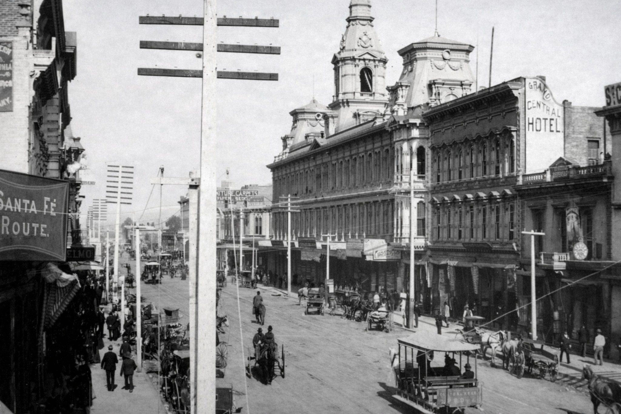 |
|
| (1888)* – View looking north on the 300 block of North Main Street. Horse-drawn streetcars, wagons, riders, and pedestrians fill the busy thoroughfare. The Baker Block stands prominently at center right, while the St. Charles Hotel can be seen in the distance farther north along Main Street. |
Historical Notes By 1888, Main Street had become one of the principal corridors of Los Angeles' first public transit system. The horse-drawn streetcars visible in this view were operated by the Los Angeles Street Railway, founded in 1874 by William H. Workman and others as the city's first urban transit line. Cars ran along fixed iron rails embedded in the unpaved street, pulled by teams of horses and mules, and connected the Plaza district with neighborhoods to the south. The fare was a nickel, and the cars ran frequently enough to become part of daily life for residents, workers, and visitors moving through the growing city. The Baker Block, seen prominently at center right, was one of the most imposing commercial buildings in nineteenth century Los Angeles. Built in 1878 by Colonel Robert S. Baker, a prominent landowner and developer who later co-founded the city of Santa Monica, the building occupied the northeast corner of Main and Arcadia Streets and featured the distinctive tower visible in several earlier views in this section. At street level, the block housed a variety of retail and commercial tenants, while upper floors provided office space for lawyers, doctors, and business firms. The Santa Fe Route sign visible at the far left reflects the arrival of the Atchison, Topeka and Santa Fe Railway in Los Angeles in 1885, an event that helped trigger the great land boom of the mid-1880s and contributed to the city's rapid population growth. |
* * * * * |
Main Street from the Plaza |
The following views look south along Main Street from near the Los Angeles Plaza, providing a broader perspective of the commercial district discussed throughout this section. Together they show how this historic corridor evolved from a busy nineteenth century business district into the preserved historic area that exists today as part of El Pueblo de Los Angeles Historical Monument. |
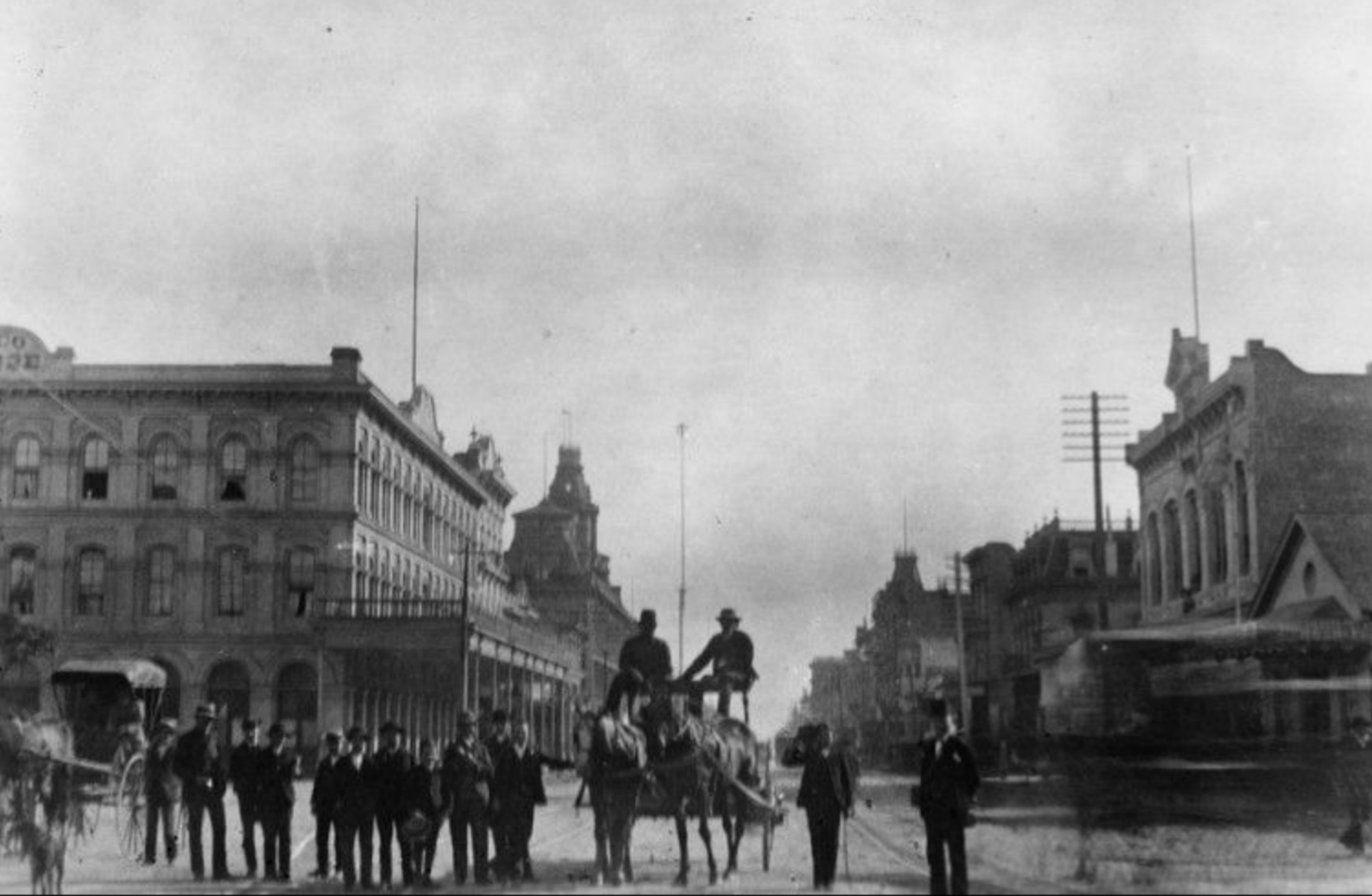 |
|
| (1883)* - View looking south on Main Street. A group of men stand beside a horse-drawn wagon while two men are seated on top. The Pico House and Baker Block are visible in the left background. The tall pole rising between the two seated men is not a flagpole, but one of the seven 150-foot electric streetlight masts installed along Main Street in 1882. |
Historical Notes This view was taken the year after C. L. Howland installed his arc-light system along Main Street. The 150-foot masts were so tall and unlike anything previously seen in Los Angeles that many residents initially mistook them for flagpoles or signal towers. Each mast carried three carbon-arc lamps of 3,000 candlepower, and Howland built a dedicated power plant to supply the current. In 1883, Howland and his investors incorporated the Los Angeles Electric Company, the first electric utility in the city. Within a decade, electric power had expanded far beyond street lighting, and Los Angeles was on its way to becoming one of the most electrified cities in the American West. The Pico House, visible at the left edge of the frame, had opened just twelve years earlier and remained one of the finest hotels on the West Coast. Click HERE to see more on LA's first electric streetlights. |
 |
|
| (2021)* – Contemporary view looking south on Main Street from in front of the Los Angeles Plaza. The Pico House, completed in 1870, is visible on the left, one of the few nineteenth century buildings still standing in this part of the city. |
Historical Notes Although nearly all of the commercial buildings seen in the earlier photographs have disappeared, the alignment of Main Street remains largely unchanged. The area now forms part of El Pueblo de Los Angeles Historical Monument, where a handful of surviving nineteenth century structures help preserve the appearance of the city's earliest commercial district. The transformation of the surrounding block reflects the broader evolution of Los Angeles from a small frontier town into a major metropolitan center. The Pico House and Plaza remain among the few surviving reminders of the commercial landscape that once defined this section of Main Street. |
Then and Now
 |
|
| (1883 vs. 2021)* – Then and Now: looking south on Main Street from in front of the Los Angeles Plaza, with the Pico House on the left. The upper image was taken in 1883; the lower image in 2021. Photo comparison by Jack Feldman. |
Historical Notes The 1883 image captures Main Street at a pivotal moment, arc-light masts newly installed, the old hotel district still intact, and the city still recognizable as a frontier town despite its growing ambitions. The 2021 view shows how completely the built environment has changed. The Pico House at the left edge of both frames is one of the only fixed reference points connecting the two images across nearly 140 years. While the buildings, transportation, and infrastructure have changed dramatically, the view still follows the same route traveled by residents, merchants, and visitors more than a century ago. The comparison illustrates both the remarkable growth of Los Angeles and the enduring importance of the Plaza district as the historic heart of the city. |
* * * * * |
Main Street: The City's Public Stage |
Main Street served as Los Angeles' principal parade route throughout the nineteenth century. From Independence Day celebrations in the 1870s to major civic gatherings in the 1880s, the stretch of Main Street between Temple Street and the Plaza drew the city's residents together for public observances, military commemorations, political rallies, and community celebrations. The photographs in this section are among the earliest surviving images of public life in Los Angeles.The Bella Union Hotel, Baker Block, Ducommun Block, and other prominent buildings along North Main Street frequently provided the backdrop for these events. Crowds filled the unpaved streets, musicians led marching groups, and spectators watched from sidewalks, balconies, rooftops, horseback, and carriage seats. These celebrations brought together residents from every part of the growing city and transformed Main Street into Los Angeles' principal public stage.The photographs in this section capture more than parades. They document the social life of early Los Angeles and reveal how civic identity was expressed in a city that was rapidly evolving from a frontier town into a modern urban center. Through these gatherings, residents celebrated national holidays, honored veterans, welcomed change, and participated in the public life of a community that was beginning to see itself as a major American city. |
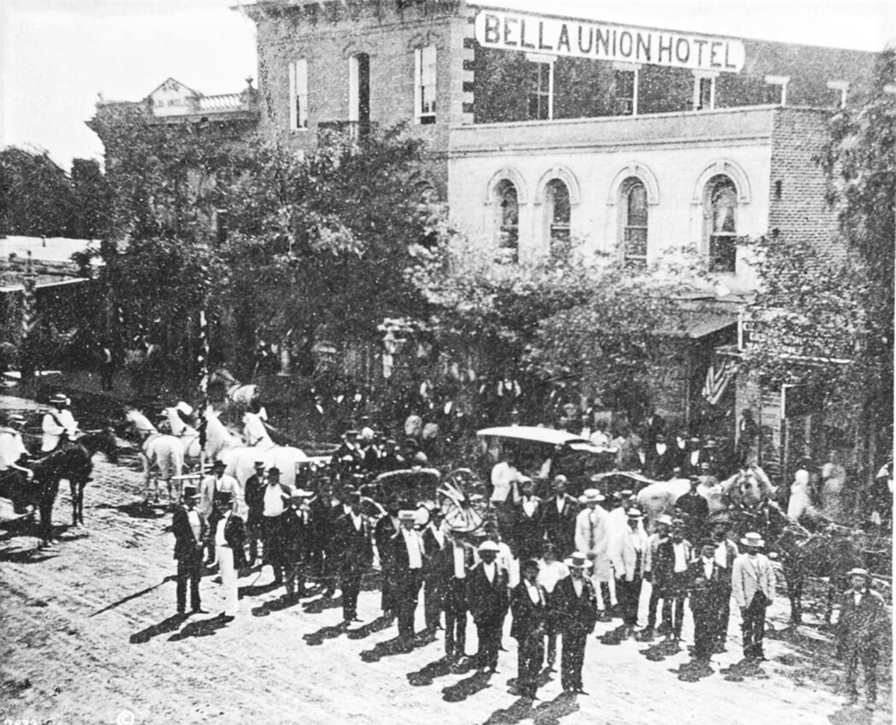 |
|
| (1871)* - A 4th of July parade on North Main Street, showing Veterans of the War of 1812 marching in formation. Spectators line the sidewalks and watch from horseback and carriages. The Bella Union Hotel is partially visible in the background behind the trees. |
Historical Notes Los Angeles had been celebrating Independence Day since at least the 1850s, and by 1871 the 4th of July parade along North Main Street had become one of the city's most anticipated annual events. This photograph documents a particularly remarkable sight: a contingent of Veterans of the War of 1812 marching in formation in front of the Bella Union Hotel. These men, who would have been in their seventies or older by 1871, were living connections to one of the earliest chapters of American military history, and their presence in a Los Angeles parade reflects the mix of long-settled Americans and newly arrived settlers who were reshaping the city during this period. The Bella Union Hotel in the background was itself a landmark with deep roots. Built in 1835 as a one-story adobe, it served as the last capitol of Mexican California under Governor Pío Pico in the 1840s, housed American military forces in 1847, and opened as a hotel in 1849. By 1871 it remained one of the most historically significant buildings in Los Angeles, making the stretch of Main Street in front of it the natural setting for the city's most important public occasions. |
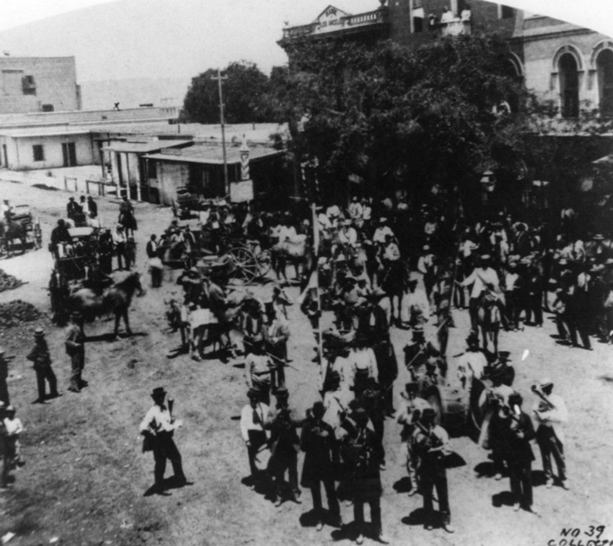 |
|
| (1871)* - View of the Fourth of July celebration on North Main Street in front of the Bella Union Hotel. A crowd has gathered along the street, spectators on horseback, in carriages, and on foot, with several musicians visible among the celebrants. |
Historical Notes This companion view captures the same 1871 celebration from a different angle, showing the scale of the gathering and the musicians who were a standard feature of Independence Day observances throughout the American West. In a city of fewer than 6,000 residents, a celebration of this size represented a genuine community event in which a significant portion of the population likely participated. North Main Street in front of the Bella Union Hotel had long served as a gathering point for civic life. Here, on October 7, 1858, the first Butterfield Overland Mail stage arrived from St. Louis, twenty-one days after departure, with Warren Hall as driver and reporter Waterman Ormsby as the only through passenger. The arrival marked Los Angeles' first direct connection to a transcontinental communications route and was celebrated throughout the city. The Bella Union Hotel building survived until the 1940s, when the entire block was demolished to accommodate the extension of Aliso Street. Today, the Hollywood Freeway passes beneath the site where Los Angeles' first hotel once stood. The site is designated California Historical Landmark No. 656. |
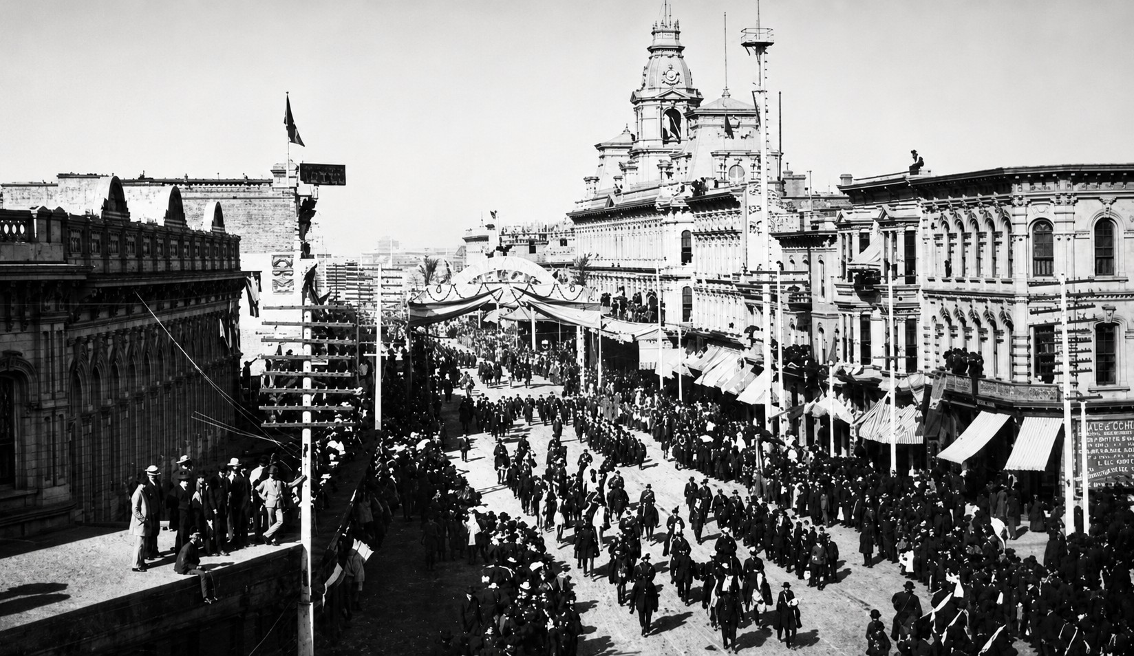 |
|
| (1882)* - View looking north on Main Street during a major parade or civic celebration. Hundreds of marchers in military formation fill the street, while spectators crowd both sidewalks and upper-floor balconies. A decorated reviewing stand draped with bunting spans the street in the middle distance. The Baker Block tower rises prominently above the scene. |
| Historical Notes
This photograph documents one of the largest public gatherings recorded on Main Street during the nineteenth century. The scale of the parade, the military formations, the decorated reviewing stand, and the dense crowds lining the sidewalks and balconies all point to a significant civic occasion, likely a Fourth of July celebration or a Grand Army of the Republic encampment, both of which drew large crowds to Main Street during the early 1880s. The Baker Block tower, rising above the reviewing stand at center, had become one of the most recognizable landmarks on the Los Angeles skyline by this date. Built by Colonel Robert S. Baker in 1878, the block represented the confidence of a city that was growing rapidly and beginning to see itself as a regional center. The contrast between the military formations in the street and the ornate commercial architecture lining the route captures something essential about Los Angeles in 1882, a frontier community that had taken on the civic ambitions of a modern American city. |
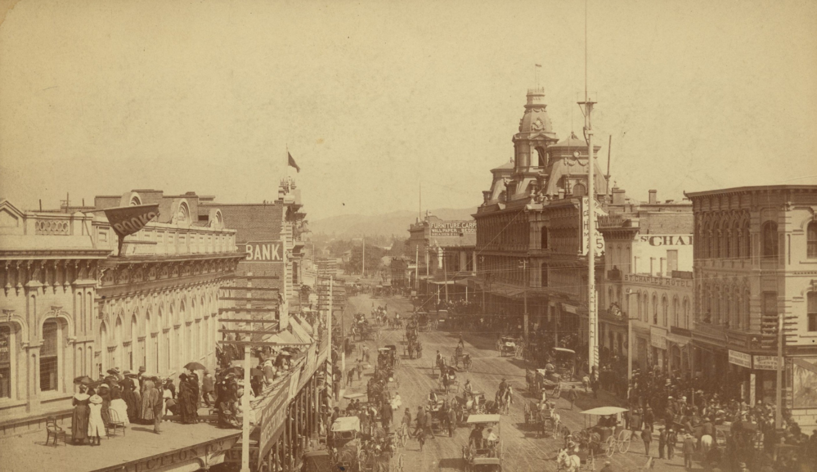 |
|
| (ca. 1886)* - Elevated view looking north on Main Street from Temple Street during a public celebration. Women with parasols and men crowd the rooftop of the building at lower left to watch the activity below. The Baker Block's ornate tower dominates the center of the view. The St. Charles Hotel is partially visible at far right, and the mountains rise in the distance. |
| Historical Notes
This elevated view is one of the finest surviving photographs of Main Street in the nineteenth century. Taken from a vantage point above Temple Street, it captures the full commercial sweep of the 300 block at the height of its development, including the Baker Block, Grand Central Hotel, St. Charles Hotel, and the dense rows of storefronts and commercial buildings that had transformed Main Street from a frontier road into a thriving urban corridor within the span of two decades. The rooftop crowd at lower left tells its own story. Women with parasols and men in formal dress have claimed one of the best vantage points in the city to watch the celebration below, a reminder that in a city without tall buildings, a commercial rooftop offered a rare elevated perspective. The electric utility pole visible at right and the telegraph and telephone wires strung between buildings reflect the infrastructure changes that were quietly transforming the urban landscape during this period, even as horse-drawn vehicles continued to dominate the unpaved streets below. By the mid-1880s, Main Street had become far more than a commercial district. It had evolved into the ceremonial heart of Los Angeles, where residents gathered to celebrate holidays, honor public figures, and participate in the civic life of a rapidly growing city. |
* * * * * |
Building a City: Schools, Institutions, and Public Life |
As Los Angeles grew during the second half of the nineteenth century, civic leaders increasingly invested in the institutions needed to support a permanent and expanding community. Schools, churches, public buildings, and other civic organizations reflected a city beginning to look beyond its frontier origins and toward a more organized future. The images in this section document some of the educational and public institutions that helped shape Los Angeles during this important period of growth. |
Spring Street School |
Los Angeles’ First Publicly Funded School |
Built in 1855, the Spring Street School was Los Angeles’ first publicly funded school established under American civil government. Located at the northwest corner of Second and Spring streets, the modest two-story brick building marked the formal beginning of organized public education in the growing city. Constructed only five years after California achieved statehood, the school reflected Los Angeles’ transition from a small pueblo into an organized American municipality supported by civic institutions and public taxation. |
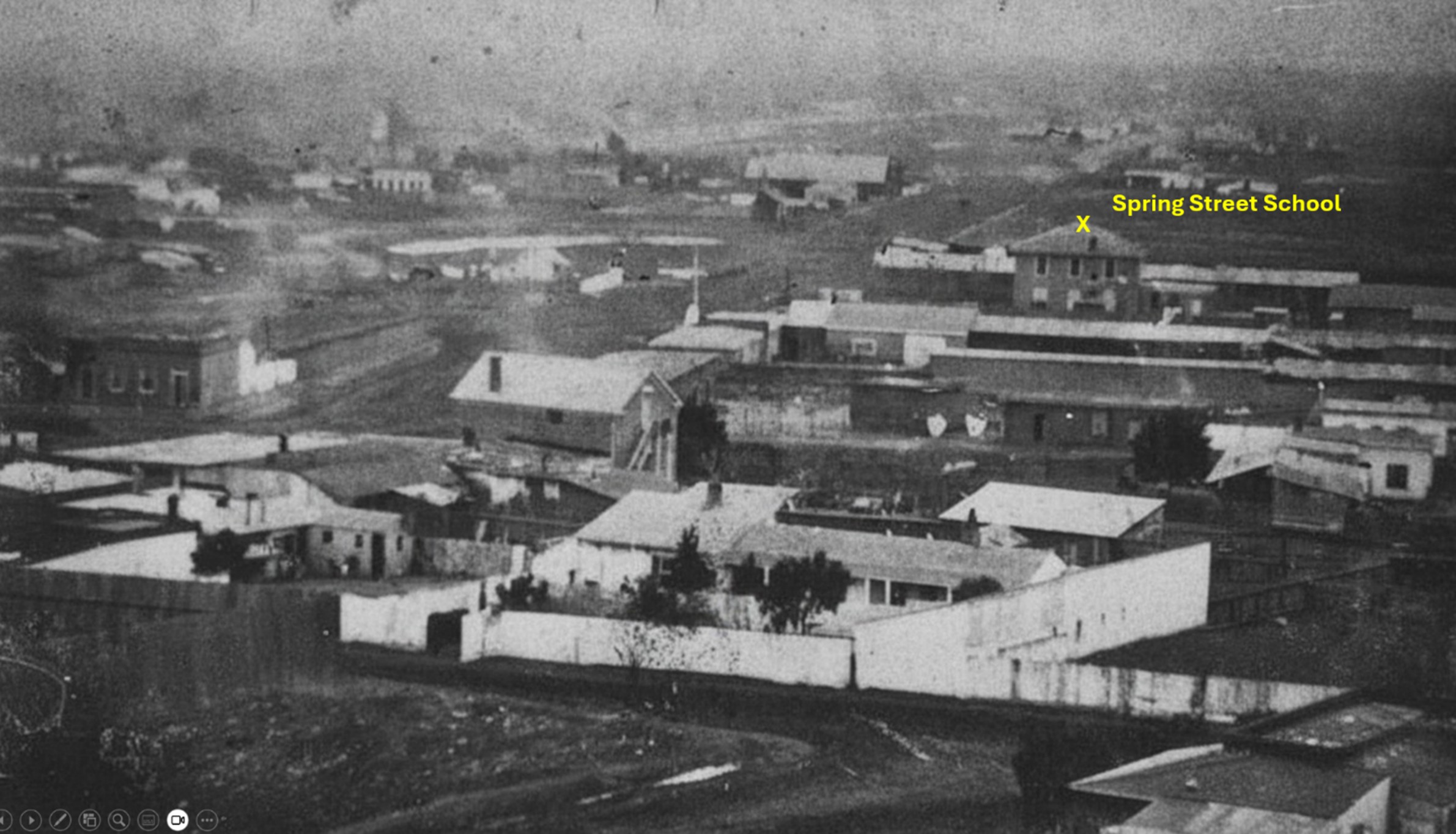 |
|
| (ca. 1860s)* - Panoramic view looking south across early Los Angeles showing the Spring Street School near the northwest corner of Second and Spring streets. The two-story building with three second-floor windows opened in 1855 and served as the city’s first publicly funded school. Image courtesy of the Natural History Museum of Los Angeles County. |
Historical Notes The Spring Street School opened on March 19, 1855, with separate departments for boys and girls from the outset. William A. Wallace, who had briefly served as publisher of the Los Angeles Star newspaper, headed the boys department, while Louisa Hayes, sister of district court judge Benjamin Hayes, oversaw the girls department. At the time, Los Angeles had only a few thousand residents, and the opening of a permanent public school building represented a major civic milestone for the young American city. By 1873, the school enrolled approximately 130 students and employed two teachers. That same year, Los Angeles reported five public schools with fourteen teachers serving a combined enrollment of 835 students. Continued population growth quickly strained available classroom space, and by 1875 the school operated on a double-session system, with one group of students attending classes in the morning and another in the afternoon. Conditions inside the overcrowded school could be difficult. In January 1876, teacher Mrs. F.A. Parker complained to the school board that she was instructing double the normal number of pupils while also acting as the school’s janitor and washing towels herself, all for a salary of eighty dollars per month. The superintendent acknowledged the situation, telling the board that Spring Street School was simply “a hard school.” The city acquired the school property in 1883, and construction of a new City Hall on the site began the following year, ending the school’s nearly three-decade presence at Second and Spring streets. After leaving the location, Spring Street School relocated farther south along Spring Street between Fifth and Sixth streets, where it continued serving students in the expanding Los Angeles public school system. Click HERE to see more about the second location of Spring Street School: |
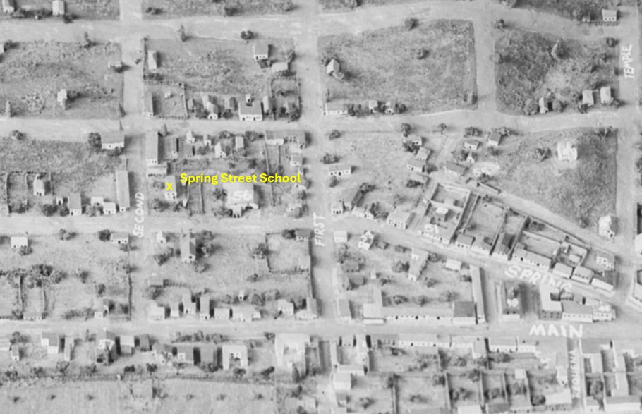 |
|
| (n.d.)* - Scale model view of early Los Angeles highlighting the northwest corner of Second and Spring streets, site of the Spring Street School from 1855 until 1884, when the property was acquired for construction of a new City Hall and later redeveloped as Times Mirror Square. |
Historical Notes The block at Second and Spring streets occupied an increasingly important position within the growing civic and commercial center of Los Angeles during the nineteenth century. When the Spring Street School opened there in 1855, much of the surrounding area still consisted of open land and scattered buildings, with the city’s primary business district concentrated farther north near the Plaza and Temple Block. Over the following decades, the district rapidly urbanized as Los Angeles expanded during the American era. After the school vacated the site in the mid-1880s, the property passed through several major phases of civic and commercial redevelopment. A City Hall building briefly occupied the location before the block later became part of Times Mirror Square, longtime headquarters of the Los Angeles Times. The Los Angeles Times Building opened in 1935 and later expanded into the larger Times Mirror Square complex. The Times Mirror Square property was sold in 2016, and the Los Angeles Times relocated its newsroom in 2018. Redevelopment plans for the historic block continue to evolve, adding yet another chapter to one of downtown Los Angeles’ most historically layered sites. |
* * * * * |
Los Angeles High School and Poundcake Hill |
When construction began in July 1872 on the hill at the corner of Fort Street and Temple Street, Los Angeles was a city of fewer than 6,000 residents with no public high school. Within a year, that would change. The building that rose on Poundcake Hill, a two story wooden structure crowned by a clock tower, became the first public high school in Los Angeles and the only one in Southern California for years to come.Perched above the surrounding streets, the school could be seen from much of the young city and quickly became one of its most recognizable landmarks. More than a place of instruction, it represented Los Angeles' growing belief that education, like government, transportation, and commerce, was essential to building a permanent and prosperous community.The photographs in this section trace more than the history of a school building. They document the emergence of public education in Los Angeles and reveal how the city increasingly viewed learning as one of its defining civic institutions. |
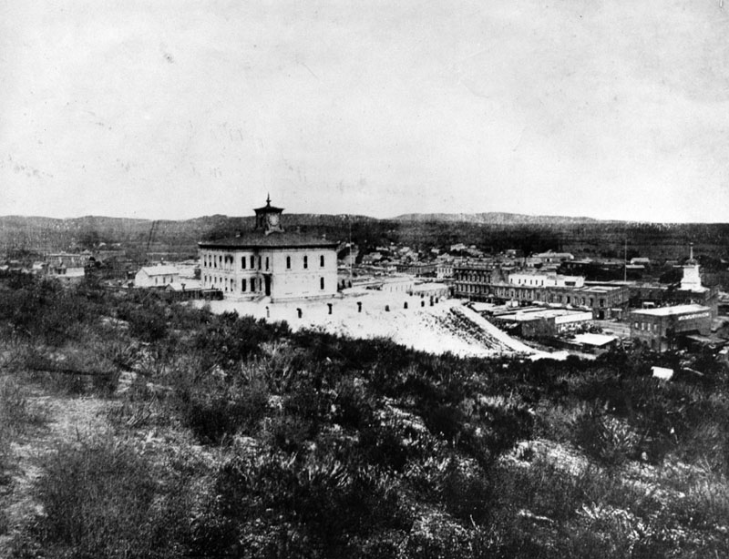 |
|
| (1873)* - Old Los Angeles High School, looking east from the hill on North Broadway at Court Street. The building in the center stands on what would later become the site of the third Los Angeles County Courthouse (1891–1936). Temple Block, with its distinctive clock tower, stands at right. Broadway, first known as Fort Street, had recently been cut through the brush in the foreground. |
Historical Notes Construction of Los Angeles' first public high school began on July 19, 1872, at the former site of Central School on Poundcake Hill, at the southeast corner of Fort Street, later renamed Broadway, and Temple Street. The building was completed in 1873 at a cost of $20,000, a substantial civic investment for a city of its size. The school's history reflects the evolving educational needs of early Los Angeles. The building originally served as Central School, offering elementary instruction. As the city's population expanded, two of its four classrooms were allocated for secondary instruction, giving rise to Los Angeles High School, the first public high school in the city. Both names remained in use simultaneously for years, with Central School referring to the elementary program and Los Angeles High School referring to the secondary one. The first graduating class, in 1875, consisted of seven students. The first principal was Reverend Dr. William T. Lucky, who served until his death in 1876. |
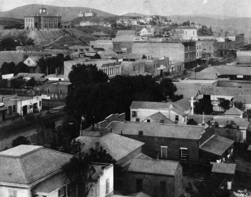 |
|
| (ca. 1875)* - View looking northwest from Main and First Streets. Los Angeles High School stands prominently atop Poundcake Hill, its clock tower visible above the surrounding landscape. |
Historical Notes From this vantage point near Main and First Streets, the school's hilltop position is unmistakable. The two story wooden building with its clock tower stood well above the surrounding commercial district, making it visible from much of early Los Angeles. A later school tradition remembered this era with the phrase, "Always a hill, always a tower, always a timepiece," capturing both the building's physical presence and its symbolic role as a civic landmark. The hill on which the school stood was known as Poundcake Hill to early residents, a name believed to derive from its rounded shape. Before the school was built, the summit had briefly been known as Telegraph Hill after a semaphore station once located there. For more than a decade, the school remained one of the most visible symbols of Los Angeles' investment in public education. |
.jpg) |
|
| (ca. 1873)* - View of Los Angeles High School on Poundcake Hill. Steep wooden stairways connected the hilltop campus to the streets below. The building's clock tower became one of the most recognized features of the early Los Angeles skyline. |
Historical Notes The schoolhouse sat high above the streets below and was reached by steep wooden stairways connecting the hilltop campus to the surrounding city. Nearby stood City Hall, the Jones Lindley Market, the Post Office, and other important public institutions, making Poundcake Hill a center of civic life as well as education. Conditions inside the building could be challenging. Enrollment increased steadily and classroom demand frequently exceeded available space. Still, for the students who climbed those wooden stairs each morning, the hilltop campus offered something unusual in early Los Angeles, a broad view across the growing city and surrounding landscape. In many ways, the school's elevated setting reflected its larger purpose: education occupied one of the highest and most visible places in Los Angeles, both physically and symbolically. |
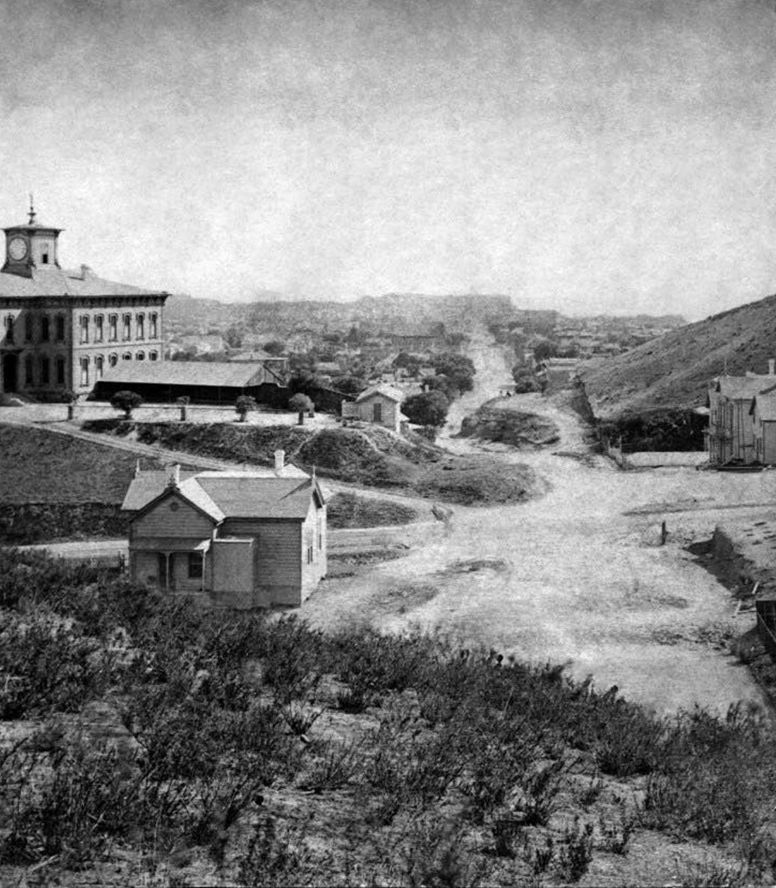 |
|
| (1875)* - Looking south on Fort Street (now Broadway) from Fort Moore Hill. Los Angeles High School crowns Poundcake Hill at Temple Street. (Henry T. Payne stereographic photograph.) |
Historical Notes This view from Fort Moore Hill shows Los Angeles High School at the height of its prominence on Poundcake Hill. Fort Street, officially renamed Broadway in 1890, climbed toward the hilltop campus, whose main façade faced the street below. The school's elevated position gave it a commanding presence over the young city and made it visible from the Plaza district and surrounding commercial areas. By 1875, Los Angeles had fewer than 10,000 residents, and the hilltop school served students from across the city. The first graduating class that year consisted of just seven students, a modest beginning for an institution that would eventually become one of the oldest and most storied public high schools in California. |
 |
|
| (ca. 1881)* - Panoramic view looking south on Fort Street, later Broadway, near Temple Street. Los Angeles High School stands on Poundcake Hill, with the First Presbyterian Church visible in the distance. |
Historical Notes This panoramic view captures Los Angeles High School only a few years before the decision was made to move it from Poundcake Hill. By 1881, the blocks below Fort Street were filling in with homes, churches, and early civic buildings, reflecting the city's rapid growth. The tall spire visible in the distance belongs to the First Presbyterian Church at Fort and Second Streets, one of the earliest major church landmarks in this emerging district. In 1886, Los Angeles County selected Poundcake Hill as the site for its new courthouse and decided to relocate the school rather than demolish it. Contractor L. O. Merrill was hired to move the structure using rollers, scaffolding, teams of horses, and crews of workers. The move began in July 1886, but the project proved more difficult than expected. At one point, the schoolhouse was left temporarily stranded in Temple Street and remained elevated long enough for streetcars to continue operating beneath it before the move was completed and the school resumed operation at its new location on Sand Street, later California Street. |
Before and After
 |
|
| (1875 vs. 1881)* – Looking south on Fort Street, renamed Broadway in 1890, toward Temple Street from Fort Moore Hill. Photo comparison by Jack Feldman. |
Historical Notes These two views show how quickly the Fort Street corridor evolved in just six years. In 1875, Los Angeles High School dominated Poundcake Hill in a landscape that remained largely open and lightly developed. By 1881, homes, churches, and commercial buildings had begun filling in below the hill, and the First Presbyterian Church spire had emerged as a new landmark on the changing skyline. The school itself was also evolving. What began as a dual purpose institution serving both elementary and secondary students increasingly shifted toward its high school identity as additional schools opened throughout the city. Fort Street, still unpaved in both views, would soon become Broadway and emerge as one of Los Angeles' most important civic and commercial corridors. |
Then and Now
 |
|
| (1875 vs 2023)* – Looking south on Broadway, originally Fort Street, at Temple Street. Los Angeles' first public high school once stood near the southeast corner as seen in the historic view above. In 1886 the school was moved to make way for construction of the third Los Angeles County Courthouse. Photo comparison by Jack Feldman. |
Historical Notes The original photograph was taken from Fort Moore Hill, which was later cut down and extensively regraded as Los Angeles expanded and the Civic Center developed. The present day view approximates the same perspective from a Google Earth vantage. In the 1875 image, Los Angeles High School crowns the hilltop at the southeast corner of Fort Street and Temple Street. Today, the Clara Shortridge Foltz Criminal Justice Center occupies a portion of that site, and no visible trace of Poundcake Hill remains. The transformation from a hilltop schoolhouse to a major courthouse complex reflects nearly 150 years of continuous civic development on one of downtown Los Angeles' most historically layered sites. Although the school and the hill disappeared, the location continues to reflect Los Angeles' longstanding practice of placing its most important public institutions at the center of civic life. |
* * * * * |
Early Views of Commercial Street |
Los Angeles’ Early Business Core |
Commercial Street was the beating commercial heart of early Los Angeles. Running east from Main Street, with its densest commercial activity concentrated in the first block to Los Angeles Street, this compact corridor packed more economic ambition into a few hundred feet than any other address in the young pueblo. By the late 1860s it was lined with dry goods emporiums, hardware merchants, saddlers, banks, hotels, and general suppliers, and its two-story brick buildings, unusual in a city still largely built of sun-dried adobe, announced that Los Angeles was beginning to trade its Mexican-era past for an American commercial future.The men who did business here were not merely shopkeepers. Isaias W. Hellman arrived from Bavaria in 1859, opened a dry goods store, and almost inadvertently invented banking in Los Angeles when customers began leaving their gold dust in his safe. Charles Louis Ducommun, a one-eyed Swiss watchmaker who had walked from Arkansas in nine months during the Gold Rush, built what would become the oldest continuously operating company founded in California. F.P.F. Temple, Massachusetts-born and California-seasoned, erected the Temple Block at the head of the street and helped bankroll the city’s first formal bank. These were not men who came to a city. They came to a village and helped build the city around them.The photographs gathered here, taken between 1869 and 1882, document Commercial Street during its peak years as Los Angeles’s undisputed commercial center. They show unpaved streets churned by horse-drawn vehicles, storefront signs competing for attention along the narrow business block, one of California’s earliest gas streetlamps casting a tentative glow at the corner, and buildings that would soon be swept away by redevelopment, freeway construction, and federal building projects. Almost nothing visible in these images survives today. What these photographs preserve, then, is not simply a street, but a defining moment. It was the moment a dusty frontier pueblo began transforming itself into a modern American city. |
 |
|
| (1869)* - Early view of Commercial Street, looking east from Main Street, just north of Temple Street, near the site of the later City Hall. On the right is Polaski and Goodwin’s Dry Goods Store, sold to them by I.W. Hellman in 1868, and where the Farmers and Merchants Bank would later do business for years. Charles Ducommun operated a combined jewelry and hardware store in the building at left foreground. In the background stands Herman Heinsch’s Saddle and Harness shop, a newly erected brick building. At lower right, one of Los Angeles’s first gas streetlamps is visible, part of the forty-three lamps installed along Main Street in 1867 by the Los Angeles Gas Company. |
Historical Notes This view looking east from Main Street shows Commercial Street at the height of its influence as Los Angeles’s principal business district. The block between Main and Los Angeles streets was the economic nerve center of the city in the late 1860s, bounded to the north by Calle de los Negros and to the south by nearby Aliso and Arcadia streets. Most structures in Los Angeles at this time were still built of sun-dried adobe, twenty inches long, fourteen inches wide, and five inches thick, making the brick buildings visible here, including Heinsch’s saddle shop in the background, conspicuous markers of a new commercial ambition. I.W. Hellman purchased the dry goods store at this corner from Adolph Portugal in 1865 at the age of twenty-two and quickly became one of the most trusted merchants in the city. Customers left their gold dust and valuables in his safe as a courtesy, and Hellman soon formalized the arrangement with printed deposit slips, effectively becoming Los Angeles’s first unofficial banker. In 1868 he formalized the operation as Hellman, Temple and Company, and in 1871 founded the Farmers and Merchants Bank, Los Angeles’s first successful formal banking institution. Herman Heinsch’s saddle shop in the background is a reminder that horses still powered nearly every aspect of transportation and commerce in 1869, and that Commercial Street served the full range of a working frontier economy. |
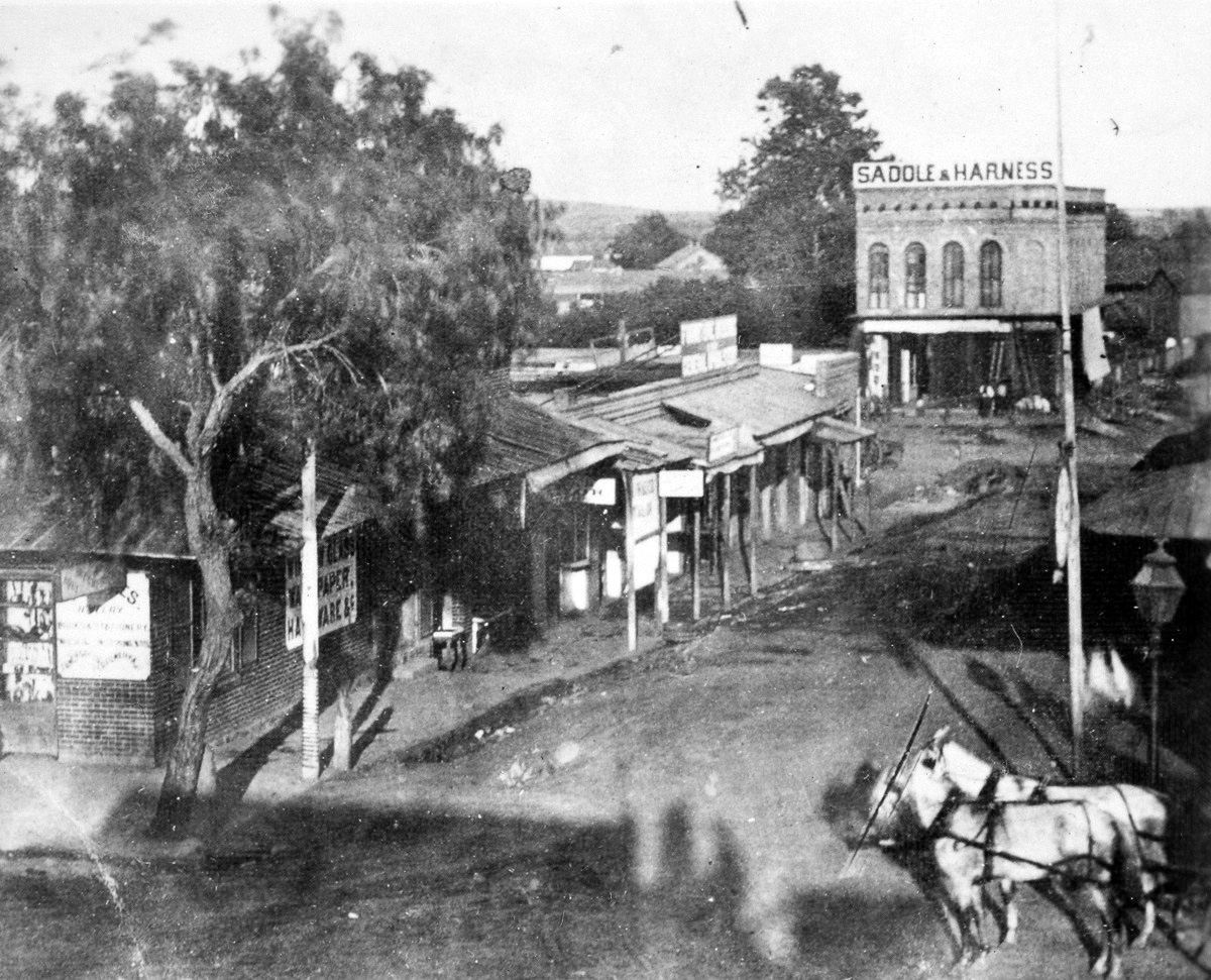 |
|
| (1869)* - A second exposure of Commercial Street, looking east from Main Street, captures the same scene with the gas streetlamp at lower right shown more clearly. On the right is Polaski and Goodwin’s Dry Goods Store, formerly Hellman’s store, sold in 1868, where the Farmers and Merchants Bank would later maintain its business for years. Charles Ducommun’s jewelry and hardware store occupies the building at left foreground, and Herman Heinsch’s Saddle and Harness shop rises in the background. The lamp at lower right is one of the forty-three gas streetlamps installed along Main Street on June 28, 1867, by the newly franchised Los Angeles Gas Company, the first gas street lighting system in Southern California. |
Historical Notes Charles Louis Ducommun was born in Switzerland and trained as a watchmaker. Drawn westward by the California Gold Rush, he made a grueling nine-month journey from Arkansas to California, partially on foot and despite having lost sight in one eye from smallpox. Arriving in Los Angeles when the pueblo had fewer than 1,600 residents, he opened a small watch repair shop and quickly expanded into hardware, mining supplies, and general merchandise. His clocks and meteorological instruments kept the city’s official time and weather records for many years. The gas streetlamp visible at lower right represents a major milestone in Los Angeles history. On June 28, 1867, the Los Angeles Gas Company, the forerunner of today’s Southern California Gas Company, installed forty-three gas lamps along Main Street, marking the arrival of gas street lighting in Southern California. The gas was initially manufactured locally from asphalt and later from oil. Each evening a lamplighter on horseback traveled from lamp to lamp igniting the flames by hand. By 1873 more than 130 gas lamps illuminated the compact downtown district before electric arc lighting gradually replaced them in the early 1880s. Click HERE to see more in Early Los Angeles Streetlights. |
 |
|
| Map detail showing the camera location and direction looking east from Main Street down Commercial Street toward Los Angeles Street. The compact one block stretch of Commercial Street, little more than 300 feet in length, contained much of Los Angeles’s commercial activity during the late 1860s. |
Historical Notes Not surprisingly, Commercial Street is much changed from what it was more than 150 years ago. The stretch shown in these early photographs disappeared long ago, as the section from Main Street to Alameda Street became occupied by commercial and government buildings, including the regional office of the Internal Revenue Service, the Edward R. Roybal Federal Building, and the Metropolitan Detention Center. What remains today are several blocks paralleling the 101 Freeway, constructed through the area during the 1950s, extending east from Alameda Street to the Los Angeles River. A short stretch of East Commercial Street still survives between Alameda Street and the river, where parking structures and commercial buildings line what has become a largely overlooked roadway. Nearby, the Metro Gold Line crosses Alameda Street south of Union Station before continuing east toward Boyle Heights and East Los Angeles. Just north of the Commercial Street business district was Calle de los Negros, one of the most infamous alleys in early Los Angeles. Running north from Aliso Street toward the Plaza, it became the site of the 1871 Chinese Massacre, the deadliest mass lynching of Chinese immigrants in American history. The tragedy served as a stark reminder that the same streets fueling Los Angeles’s early commercial growth also witnessed some of the darkest episodes in the city’s history. The alley later disappeared during the widening of Los Angeles Street and subsequent redevelopment projects. |
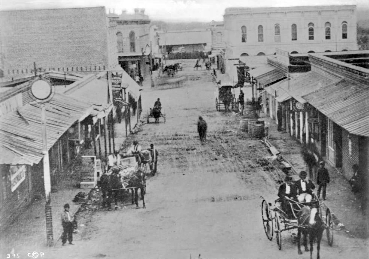 |
|
| (ca. 1870)* - View of Commercial Street, looking east from Main Street. The two-story White House Hotel is seen at far right on the southeast corner of Commercial and Los Angeles Streets. At left is one of the first two-story buildings built in Los Angeles, by I.W. Hellman in 1870. Ducommun Hardware is at the first left-hand corner. This was the business center of Los Angeles at the time. Horse-drawn carriages are in the unpaved street. |
Historical Notes Isaias Wolf Hellman was born in Reckendorf, Bavaria, in 1842 and arrived in Los Angeles in 1859. After opening his own dry goods store in 1865, he quickly emerged as one of the city’s most influential businessmen. His two-story brick building erected here in 1870 was both practical and symbolic, signaling permanence at a time when much of Los Angeles still consisted of adobe structures. Hellman later helped finance the Los Angeles Railway and the Pacific Electric Railway with Henry Huntington, helped establish the University of Southern California alongside Ozro W. Childs and former Governor John G. Downey, and served as a regent of the University of California for nearly four decades. The White House Hotel at the southeast corner of Commercial and Los Angeles streets catered primarily to merchants, ranchers, lawyers, and travelers arriving in the city by stagecoach years before rail service reached Los Angeles in 1876. Hotels of this period were modest frontier establishments, but their locations were important gathering places for business and civic activity. As Los Angeles expanded during the great railroad and real estate boom of the 1880s, larger and more elaborate hotels gradually replaced the smaller hostelries of the pueblo era. |
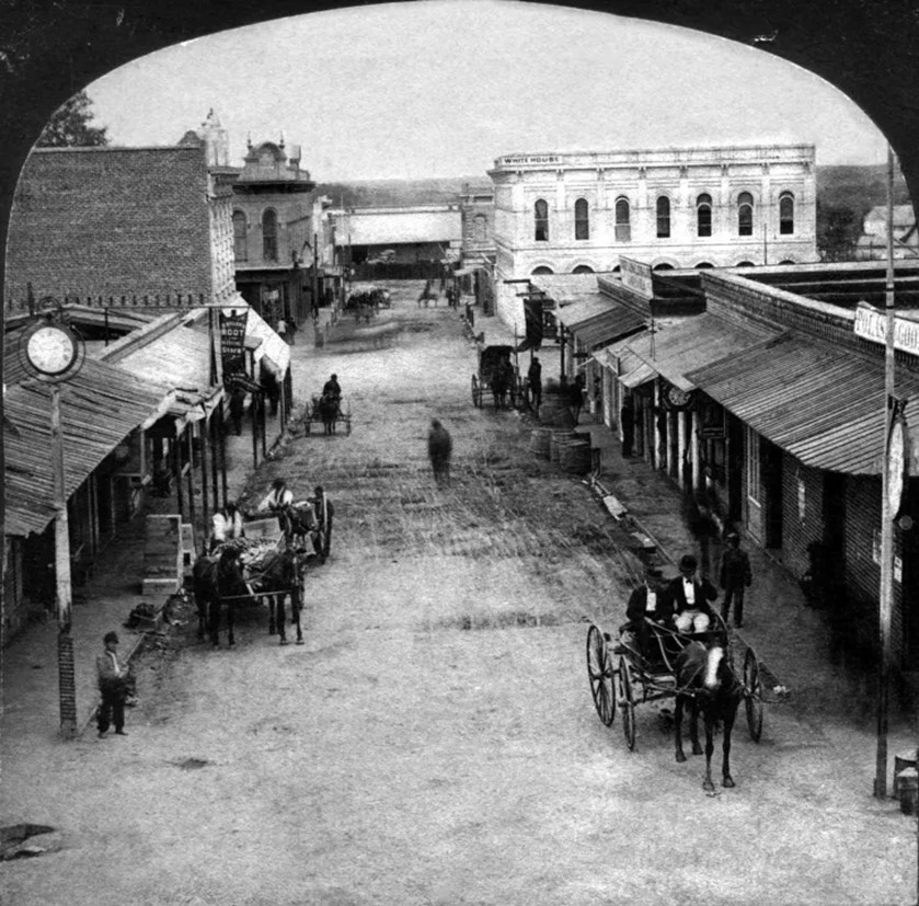 |
|
| (1872)* - Stereoscopic photograph showing Commercial Street looking east from Main Street, taken by William M. Godfrey from a position just north of Temple Street and F.P.F. Temple’s Temple Block. Ducommun’s hardware and jewelry store occupies the left foreground, with Polaski and Goodwin’s dry goods store at right. The street, sometimes called “New Commercial Street” in period sources, was devoted almost entirely to commerce for the length of this view. Photo by William M. Godfrey, Homestead Collection. |
Historical Notes Francis Pliny Fisk Temple, better known as F.P.F. Temple, arrived in Los Angeles from Massachusetts in 1841 and eventually became one of the city’s leading businessmen and civic figures. He served as Los Angeles’s second treasurer in 1851 and as a founding member of the first Los Angeles County Board of Supervisors the following year. His Temple Block, located at the intersection of Main, Spring, and Temple streets, became one of the most important commercial complexes in early Los Angeles. By the mid-1870s Temple ranked among the wealthiest men in Southern California, with investments in banking, ranching, oil, real estate, and water development. The collapse of the Temple and Workman Bank in 1875, however, destroyed much of his fortune and marked the end of an era for many of the city’s early pioneer businessmen. William M. Godfrey operated one of Los Angeles’s earliest photography studios during the 1870s, known as the Sunbeam Gallery, which he later sold to photographer Henry T. Payne. Many of Godfrey’s views were subsequently reissued under Payne’s name, creating occasional confusion in later image attributions. The stereoscopic format used here, twin photographs mounted side by side to create a three-dimensional effect when viewed through a stereoscope, was enormously popular during the nineteenth century. Godfrey’s Commercial Street views, taken during Los Angeles’s first sustained growth period after the Civil War, remain among the finest surviving visual documents of the city’s transition from frontier pueblo to emerging commercial center. |
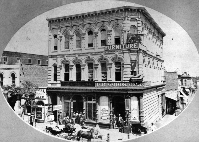 |
|
| (ca. 1882)* - View of the northeast corner of Main and Commercial streets, showing the Hardware Store of C. Ducommun alongside S. Prager’s dry goods store and a furniture store at 204 North Main Street, later renumbered 304 North Main Street after 1890. The expanded commercial frontage reflects the remarkable growth of Ducommun’s enterprise from its origins as a one-room watch repair shop established during the Gold Rush era. |
Historical Notes Charles Ducommun died in 1896, leaving the business to his sons, who incorporated it in 1907 as the Ducommun Hardware Company. Over time the firm evolved from a local hardware supplier into a major industrial materials company serving Southern California’s growing oil, agricultural, aviation, and manufacturing industries. Ducommun sheet metal was later used in the construction of the Spirit of St. Louis in 1927, and during World War II the company supplied both the aviation and shipbuilding industries. Today Ducommun Incorporated remains one of the oldest continuously operating companies founded in California. Samuel Prager’s dry goods store, visible near the corner, represented part of the broader network of German and Central European Jewish merchants who played an essential role in shaping Los Angeles’s early commercial economy. Like Hellman and Ducommun, these merchants often extended credit to ranchers and farmers, financed early civic improvements, and helped bring a sense of permanence and stability to the growing city. Within only a few years, however, the great railroad boom of the 1880s would transform Los Angeles on a much larger scale, shifting the commercial center farther south and west and gradually leaving behind the intimate pueblo-era business district seen in these photographs. |
Commercial Street’s Legacy Within only a few decades, the compact Commercial Street district seen in these photographs would be eclipsed by a rapidly expanding downtown that pushed south and west toward Spring Street, Broadway, and beyond. Many of the buildings shown here disappeared through redevelopment, widening streets, freeway construction, and federal projects, erasing much of the physical landscape of early Los Angeles commerce. Yet these images preserve something extraordinarily important. They capture the moment Los Angeles first began to think of itself not merely as a frontier pueblo, but as a modern American city. The merchants, bankers, hotel operators, and hardware dealers of Commercial Street helped establish the commercial foundations upon which the future metropolis would rise. Today, only a short stretch of East Commercial Street survives between Alameda Street and the Los Angeles River, one of the last physical reminders of the city’s original business core. Click HERE to see more on the Ducommun Building. Click HERE to see more Early Views of Commercial Street (1950s thru Today) |
* * * * * |
Main Street North of Commercial Street |
A View of Los Angeles’s Early Business Corridor |
This 1870 view looking north along Main Street from the corner of Commercial Street captures the storefronts, signage, and growing commercial activity of early downtown Los Angeles. |
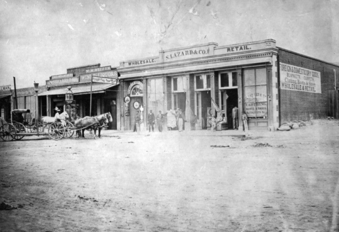 |
|
| (1870)* - View of Main Street looking north from Commercial Street. At left is Theodore Wollweber’s Apothecaries Hall at No. 59, displaying its trade symbol on a pole out front, followed by W.M. Buffum’s Wines and Liquors, the Republican Printing Office, and S. Lazard and Co.’s foreign and domestic dry goods store at No. 53. At the corner of Main and Commercial streets at far left is the store purchased in 1865 by twenty-two-year-old I.W. Hellman from Adolph Portugal. Horse-drawn vehicles wait in the unpaved street, and a gas streetlamp is visible behind them. |
Historical Notes Solomon Lazard was one of the most prominent merchants in early Los Angeles and a close contemporary of Hellman and Ducommun. Born in France, he arrived in Los Angeles during the 1850s and built a substantial dry goods business serving the city’s ranching and farming communities. Lazard was also active in civic affairs and helped establish the Los Angeles Water Company, one of the city’s earliest private water systems. His store at No. 53 Main Street, visible in this photograph, was among the important commercial establishments lining the growing business corridor north of Commercial Street. Theodore Wollweber’s Apothecaries Hall, identified by its trade symbol mounted on a pole, represented one of the few specialized professional establishments in Los Angeles during this era. Most merchants still sold a broad assortment of goods rather than focusing on a single trade, making a dedicated pharmacy a sign of the city’s growing sophistication. Nearby, the Republican Printing Office reflected another emerging institution in early Los Angeles life: the press. The city had supported newspapers since the founding of the Los Angeles Star in 1851, and by 1870 multiple printing offices served an expanding population eager for business, political, and community news. |
* * * * * |
North Los Angeles Street and the Arcadia Block |
North Los Angeles Street was one of the earliest commercial corridors in the young city, extending south from the Plaza through a district of adobe buildings, brick storefronts, warehouses, and businesses that served the daily needs of a rapidly growing community. During the decades following American annexation, the street became home to some of the city's most important merchants, financiers, and entrepreneurs, helping transform Los Angeles from a frontier pueblo into an emerging commercial center.The images in this section document North Los Angeles Street during the 1860s through the 1890s, a period when the city was evolving from its Mexican-era adobe origins into an increasingly modern American city. The Arcadia Block, completed in 1859 by Abel Stearns, stood at the center of this transformation as the first major brick commercial building in Los Angeles. Together, these photographs preserve a streetscape where merchants, bankers, craftsmen, and property owners helped lay the foundations of modern Los Angeles, long before redevelopment and freeway construction erased much of the district. |
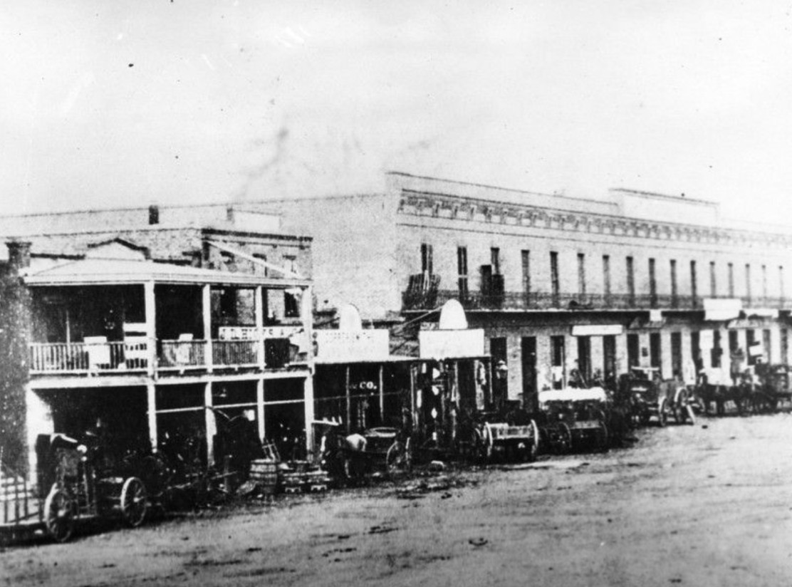 |
|
| (1870s)* – View showing Don Abel Stearns' Arcadia Block on North Los Angeles Street, the first major brick commercial building in Los Angeles. Numerous horse-drawn vehicles are parked in front of the storefronts. The building was later demolished and its site ultimately disappeared beneath the Hollywood Freeway. |
Historical Notes The Arcadia Block, completed in 1859 at a reported cost of $80,000, was among the most ambitious commercial projects yet undertaken in Los Angeles. Abel Stearns, one of the wealthiest merchants and landowners in Southern California, constructed the two-story brick building at the southwest corner of Los Angeles and Arcadia streets and named it after his wife, Arcadia Bandini de Stearns. The building marked a significant departure from the adobe architecture that had dominated Los Angeles since its founding and signaled the city's growing commercial ambitions. For many years the Arcadia Block housed Harris Newmark and Company, one of the city's leading wholesale merchants. The second floor contained Stearns Hall, a popular venue for theatrical performances, musical entertainment, political meetings, and civic gatherings. The building remained an important commercial landmark for decades before being demolished in 1927. Its site was later absorbed into the redevelopment projects and freeway construction that transformed downtown Los Angeles during the twentieth century. |
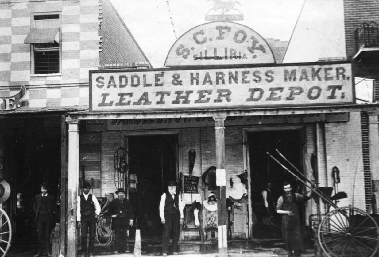 |
|
| (1860s)* - Exterior view of the S. C. Foy Saddlery Shop at 217 Los Angeles Street. The store sign reads "Saddle and Harness Maker, Leather Depot" and features a silhouetted prancing horse. Saddles, tack, and leather goods are displayed outside while several men pose for the camera |
Historical Notes Samuel Calvert Foy arrived in Los Angeles in 1854 and established what became one of the city's oldest continuously operating businesses. In an era when nearly all transportation depended upon horses, wagons, and stagecoaches, saddle makers and harness suppliers played an essential role in daily life. Foy's shop served ranchers, teamsters, merchants, and travelers throughout Southern California. The success of businesses such as Foy's reflected the importance of North Los Angeles Street as a commercial center during the nineteenth century. The corridor linked the Plaza with surrounding neighborhoods and provided a convenient location for merchants whose goods and services supported the city's growing population. The Foy family remained active in Los Angeles civic life for generations, helping shape the city's development beyond the commercial district. |
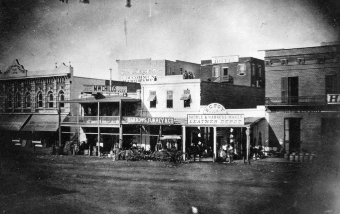 |
|
| (1870s)* - View of the west side of North Los Angeles Street between Commercial and Arcadia streets. The Samuel C. Foy Leather Depot stands at center right, while one of I. W. Hellman's early commercial buildings appears at far left. |
Historical Notes This view captures one of the busiest commercial blocks in early Los Angeles. By the 1870s, North Los Angeles Street was lined with merchants, warehouses, and professional offices serving a community that was rapidly expanding beyond its pueblo origins. The street's proximity to the Plaza ensured a steady flow of customers and commerce. Among the businessmen associated with this district was Isaias W. Hellman, who arrived in Los Angeles in 1859 and went on to become one of the most influential financiers in California history. From these early commercial beginnings, Hellman helped establish banking institutions that provided capital for railroads, newspapers, real estate ventures, and emerging industries throughout Southern California. The buildings visible here represent the commercial environment from which much of modern Los Angeles business activity emerged. |
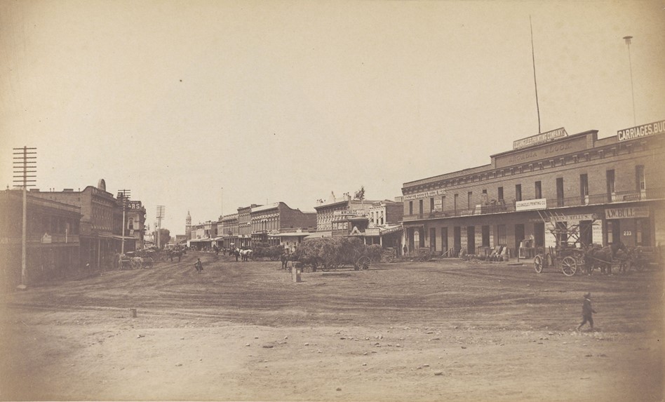 |
|
| (ca. 1890)* - View looking south on Los Angeles Street showing hay wagons and commercial buildings lining the street. At right, the Arcadia Block houses the Los Angeles Printing Company and other businesses, illustrating the building's continued commercial use more than thirty years after its construction. |
Historical Notes By the late 1880s and early 1890s, the Arcadia Block had adapted to the changing needs of a rapidly growing city. Businesses associated with printing, manufacturing, and light industry occupied spaces once used by earlier merchants and wholesalers. The building's continued use reflected both its durability and its strategic location near the historic Plaza. Los Angeles itself had changed dramatically since the Arcadia Block was constructed. The arrival of the railroad, followed by the land boom of the 1880s, transformed the city from a small town into a rapidly growing urban center. As newer commercial districts developed farther south, older streets near the Plaza increasingly took on specialized commercial and industrial functions. |
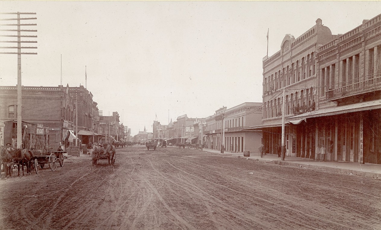 |
|
| (ca. 1895)* - View looking south on Los Angeles Street toward Arcadia Street. The Arcadia Block occupies the southwest corner at left, while the Jennette Block and Garnier Building are visible farther north along the street. |
Historical Notes This photograph captures North Los Angeles Street near the end of the nineteenth century, when the corridor still retained much of its early commercial character despite the city's explosive growth. The Arcadia Block remained a prominent landmark, while newer buildings reflected the increasing density and diversity of downtown Los Angeles. The Garnier Building, visible at right, became closely associated with Los Angeles' original Chinatown. Built in 1890 by French immigrant Philippe Garnier, the structure housed businesses, community organizations, schools, and social activities serving Chinese American residents during a challenging period in the city's history. Today it remains one of the few surviving buildings from this historic district. |
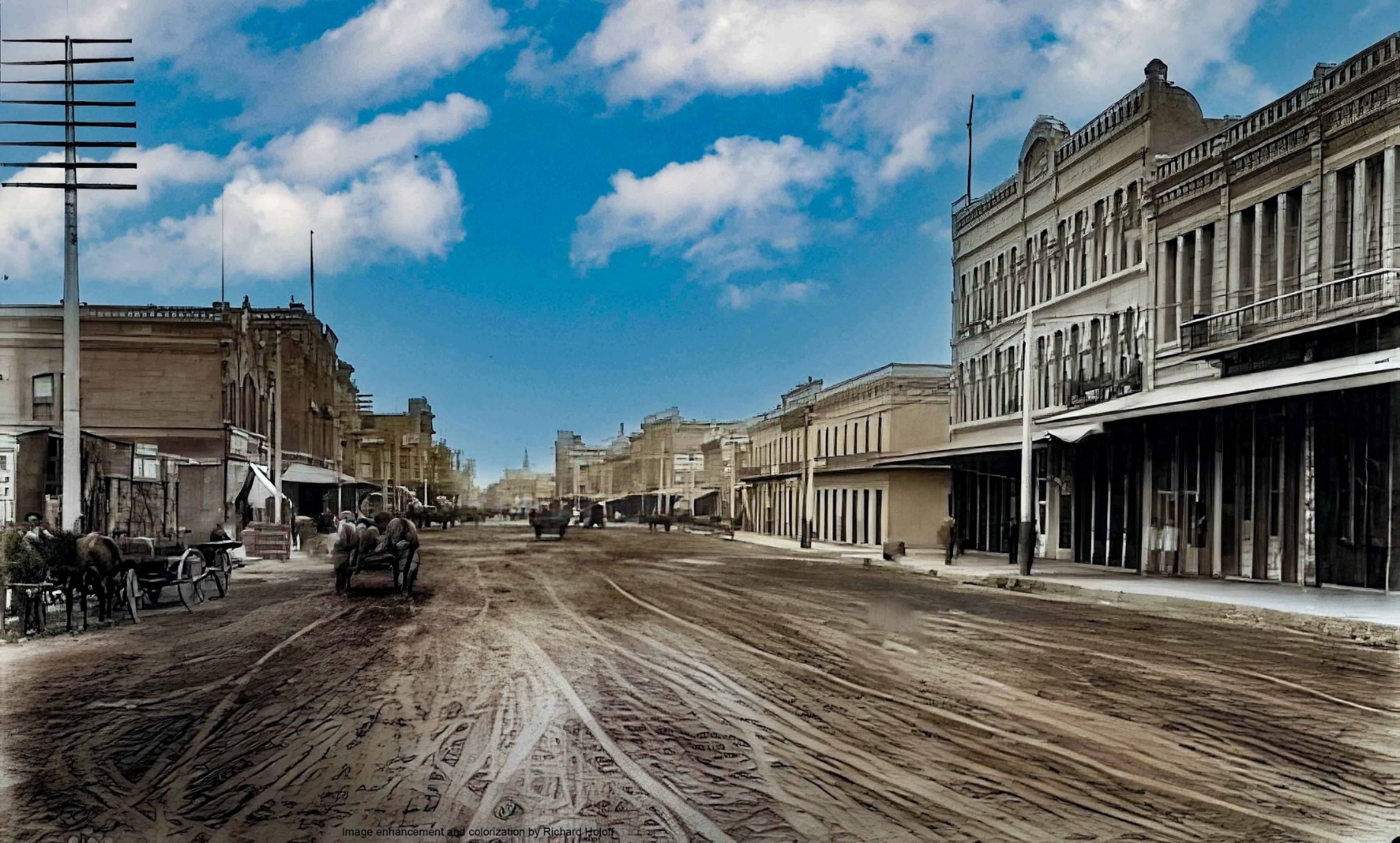 |
|
| (ca. 1895)* - Colorized view looking south on Los Angeles Street toward Arcadia Street. The Arcadia Block is visible at left, while the Jennette and Garnier buildings stand beyond. Image enhancement and colorization by Richard Holoff. |
Historical Notes This colorized interpretation helps bring the late nineteenth-century streetscape to life, offering a glimpse of the commercial corridor as it might have appeared during its final decades of prominence. The image highlights the architectural variety and street activity that characterized North Los Angeles Street during a period of remarkable growth and change. Of the major buildings visible in this scene, only the Garnier Building survives today. The Arcadia Block was demolished in 1927, while portions of the surrounding district were later removed during construction of the Hollywood Freeway and related street improvements. The surviving Garnier Building, now home to the Chinese American Museum, serves as one of the last physical reminders of the historic commercial district depicted in these photographs. |
* * * * * |
Downey Block |
The Downey Block stood at the northwest corner of Main and Temple streets, one of the most prominent commercial addresses in nineteenth-century Los Angeles. Developed by former California governor John Gately Downey, the Italianate-style brick building became a fixture of Temple Square, the triangular junction of Main, Spring, and Temple streets that served as the commercial and civic heart of the growing city. From its completion in 1871 until its demolition in 1904, the Downey Block witnessed some of the earliest public celebrations in Los Angeles history. |
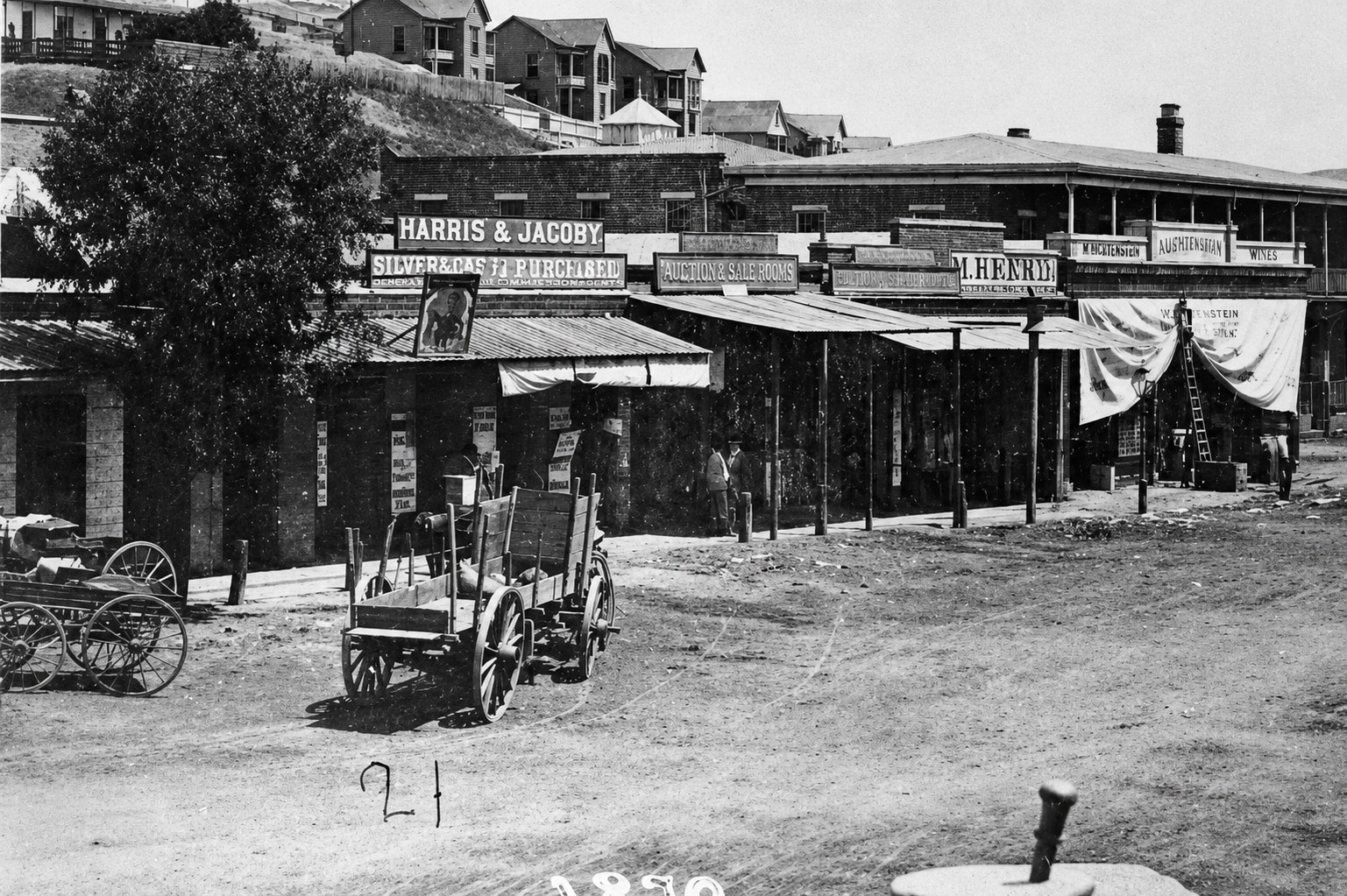 |
|
| (ca. 1870)* - One side of a stereoscopic photograph showing the original one-story commercial building that preceded the Downey Block on Main Street. Horse-drawn wagons line the unpaved street in front of covered wooden walkways and storefronts displaying prominent commercial signs. The structure was replaced in 1871 by the larger two-story Italianate-style Downey Block built on the same site. |
Historical Notes Construction on the Downey Block began in 1869 and was completed in 1871. The building was developed by John Gately Downey, an Irish-born pharmacist who arrived in Los Angeles in 1850 and opened the city’s first pharmacy before entering politics. He served as California’s seventh governor from 1860 to 1862, assuming office when Governor Milton Latham resigned to accept a United States Senate appointment. After leaving the governorship, Downey returned to Los Angeles and became one of its most influential real estate developers and civic leaders. Among his many contributions to the city, Downey co-founded Farmers and Merchants Bank in 1871 alongside Isaias W. Hellman, serving as the bank’s first president. The bank was the first incorporated bank in Los Angeles and played a central role in financing the city’s rapid growth. Downey also helped lay the groundwork for the founding of the University of Southern California in 1879, and a street on the USC campus bears his name. The city of Downey, southeast of Los Angeles, was named in his honor when he subdivided his landholdings there in the 1870s. |
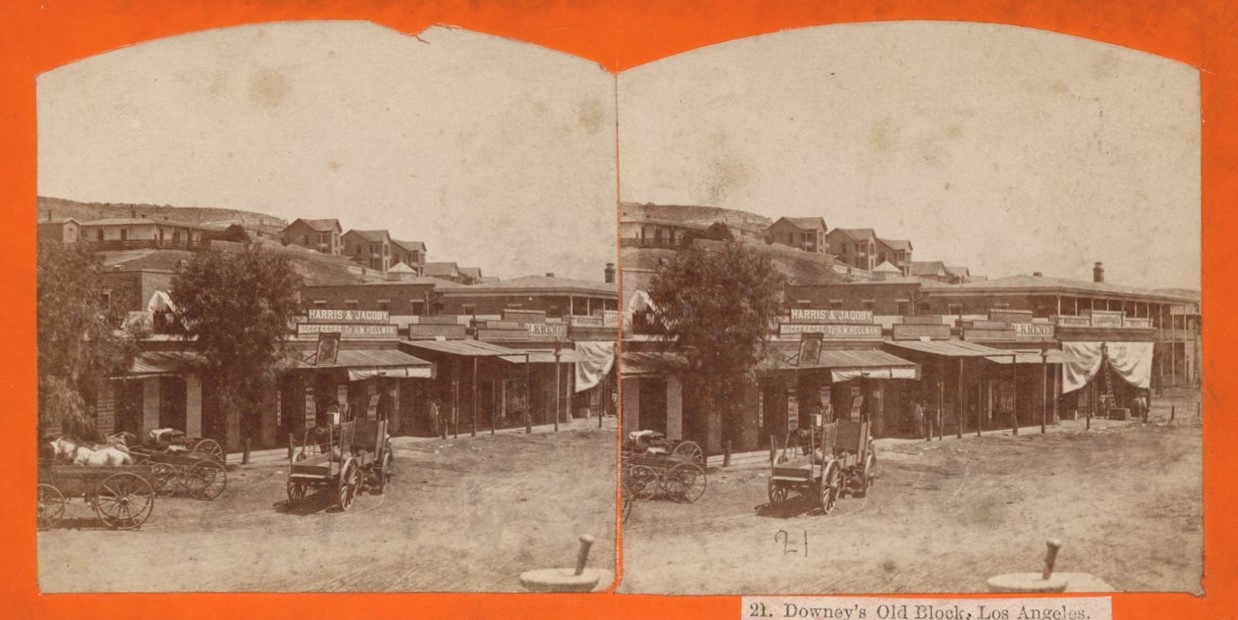 |
|
| (ca. 1870)* - Stereoscopic view looking northwest at the original one-story commercial building that preceded the Downey Block on Main Street, showing storefronts bearing signs for “Harris & Jacoby, Successors to H.W. Hellman” and “M. Kremer.” Fort Moore Hill is visible in the background. The Lafayette Hotel appears at far right. The structure was replaced in 1871 by the larger two-story Italianate-style Downey Block built on the same site.-style Downey Block built on the same site. |
Historical Notes The signs visible in this view offer a glimpse into the commercial life of early Los Angeles. Harris and Jacoby was formed in 1870 when the Jacoby brothers and Leopold Harris purchased the dry goods business of Herman W. Hellman, making them his successors at one of the city’s leading retail establishments. M. Kremer, also visible in the photograph, operated a dry goods business on the site and is noted as a forerunner of the City of Paris, which became the city’s first department store. Both businesses operated from the earlier one-story structure that stood on the corner before the new Downey Block was completed in 1871. Among the tenants of the new Downey Block after its completion were Michel Levy and Joseph Coblentz, whose wholesale liquor and tobacco business opened when the building was finished. Their painted sign advertising wines, brandies, whiskeys, and beer was a familiar sight on the Main Street facade for nearly a decade. The building’s mix of retail merchants, professional offices, and wholesale dealers reflected its central role as a commercial hub at the busiest intersection in early Los Angeles. |
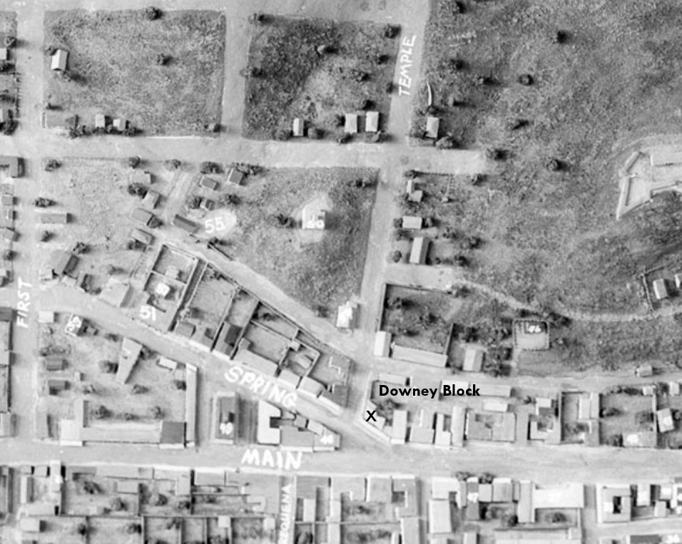 |
|
| (n.d)* - Scale model view of early Los Angeles highlighting the location of the Downey Block at the northwest corner of Main and Temple streets, at the heart of Temple Square. |
Historical Notes The Downey Block occupied a strategically prominent position at Temple Square, the triangular junction where Main, Spring, and Temple streets converged. This unique three-way intersection was the focal point of commercial and civic life in Los Angeles for much of the latter half of the nineteenth century, housing law offices, banks, retail merchants, and professional firms of every kind. The alignment was permanently altered in 1928 when construction of the current Los Angeles City Hall erased the old intersection from the street grid. The Downey Block was demolished in 1904 and replaced by a Federal Building in 1910, which was itself replaced by the current United States Courthouse, opened in 1940, which still stands directly across from City Hall today. More early views the Downey Block HERE. |
* * * * * |
The Hills Above the City |
While the Plaza and surrounding streets formed the commercial and civic heart of early Los Angeles, the hills rising immediately west of the young city offered a different perspective. From these elevated vantage points, residents could look across the entire pueblo, observing a landscape of adobe buildings, dirt roads, vineyards, orchards, and scattered homes stretching outward from the Plaza. The photographs in this section capture Los Angeles at a moment when much of the city could still be viewed from a single hillside.The views from Poundcake Hill, Fort Street, and the slopes of early Bunker Hill document areas that would later become some of the most important districts in Los Angeles. Fort Street would be renamed Broadway and emerge as the city's premier commercial corridor. Bunker Hill would evolve into one of Southern California's most prestigious residential neighborhoods before eventually giving way to the modern skyline of downtown Los Angeles. Schools, churches, courthouses, and civic institutions would soon occupy many of the open hillsides visible in these early photographs.Together, these images preserve a city on the threshold of dramatic change. They reveal not only what Los Angeles looked like during the 1860s and 1870s, but also the natural terrain that shaped its development. Many of the hills, slopes, and viewpoints seen here were later graded, excavated, or entirely removed as the growing city reshaped its landscape to accommodate expansion. As a result, these photographs provide some of the last surviving views of a Los Angeles that no longer exists. |
Fort Street (Later Broadway) and 1st Street |
One of the earliest known photographs of this part of Los Angeles, this remarkable 1860 view captures the area around Fort Street and First Street at a time when the city still retained much of its rural pueblo character. The image preserves an almost unrecognizable landscape of dirt roads, scattered cottages, rolling hills, and open land decades before Broadway became one of downtown Los Angeles' busiest commercial corridors and before Bunker Hill rose as the city's premier residential neighborhood. |
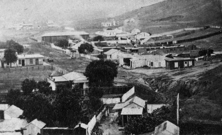 |
|
| (1860)* - View looking south along Fort Street, later renamed Broadway, from the summit of Poundcake Hill, also known over the years as Telegraph Hill and Court House Hill. The unpaved roadway runs through a sparsely developed landscape lined with modest wood-frame cottages and fenced lots typical of early American era Los Angeles. Near center right, the intersection of Fort and First streets reveals the steep natural contours of the hillside terrain before later grading reshaped the area. Rising in the background at right is Bunker Hill, still largely open land at this date, decades before it became Los Angeles’ premier residential district. |
Historical Notes The hill from which this photograph was taken offered some of the finest views of early Los Angeles and later became one of the city's most important civic sites. Known at various times as Telegraph Hill, Court House Hill, and Poundcake Hill, it served as both a prominent landmark and one of the finest observation points overlooking the growing pueblo below. That changed rapidly during the final decades of the nineteenth century. In 1872, Central School was constructed near the summit at Fort and Temple streets. The building also housed Los Angeles High School, the first public high school in Los Angeles and the first in Southern California for a number of years. In 1887 the school building was relocated to nearby Fort Moore Hill, clearing the site for future civic development. Four years later, the massive red sandstone courthouse opened atop the hill, giving rise to the popular Court House Hill name. Its rounded profile also inspired the enduring nickname Poundcake Hill, a reference that survived long after the landmark itself disappeared. Fort Street itself was renamed Broadway in February 1890, largely at the urging of local printer Fred Lind Alles, who petitioned the city after German-speaking residents repeatedly confused Fort Street with Fourth Street due to the absence of the "th" sound in German. By the early twentieth century, extensive grading tied to Civic Center expansion permanently erased the hill from the landscape. The dramatic slopes, stairways, and elevated views seen in early photographs like this one vanished beneath a newly leveled downtown street grid, fundamentally reshaping the physical geography of central Los Angeles. |
* * * * * |
Views from Poundcake Hill: Early Broadway and Bunker Hill |
During the 1860s, Poundcake Hill provided one of the finest vantage points from which to observe the growing city of Los Angeles. From its summit, photographers looked south across Fort Street (later Broadway), Bunker Hill, schools, residences, commercial buildings, and open land that still reflected the city's pueblo era origins.The views below capture Los Angeles at a pivotal moment in its history. Although the city remained relatively small, many of the streets, institutions, and neighborhoods that would shape downtown Los Angeles for generations were already beginning to emerge. Together, these photographs provide a remarkable record of a city on the threshold of dramatic growth and change. |
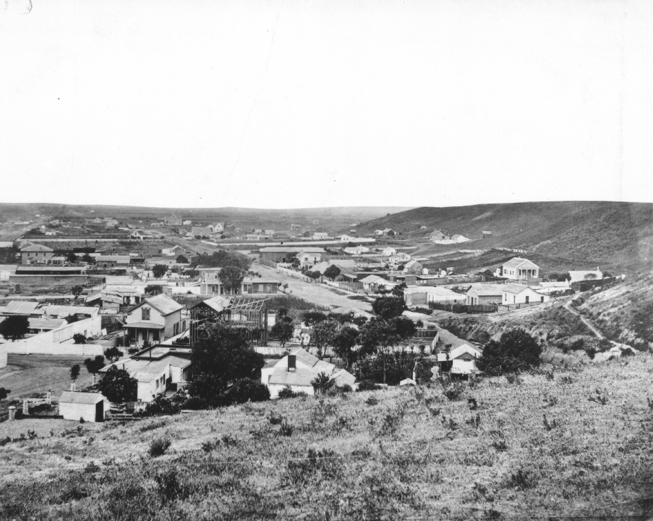 |
|
| (1868)* - View looking south from Poundcake Hill. Fort Street (later Broadway) runs diagonally through the center of the photograph, while Bunker Hill rises at right before the residential development that would soon transform its slopes. |
Historical Notes This sweeping panorama captures Los Angeles at a time when much of the city remained lightly developed. Fort Street, later renamed Broadway, runs diagonally through the center of the view and would eventually become one of downtown's principal commercial corridors. At right, Bunker Hill remains largely barren, years before Prudent Beaudry's real estate ventures transformed it into one of the city's most desirable residential neighborhoods. Many of the streets visible here remained unpaved, and large portions of the surrounding landscape were occupied by open land, scattered residences, gardens, and agricultural uses. Third Street can be seen in the distance running from right to left, while Hill Street at the base of Bunker Hill is little more than a dirt path. The photograph illustrates how compact Los Angeles remained during the late 1860s, with most development concentrated near the Plaza and along a handful of principal streets extending outward from the historic pueblo. |
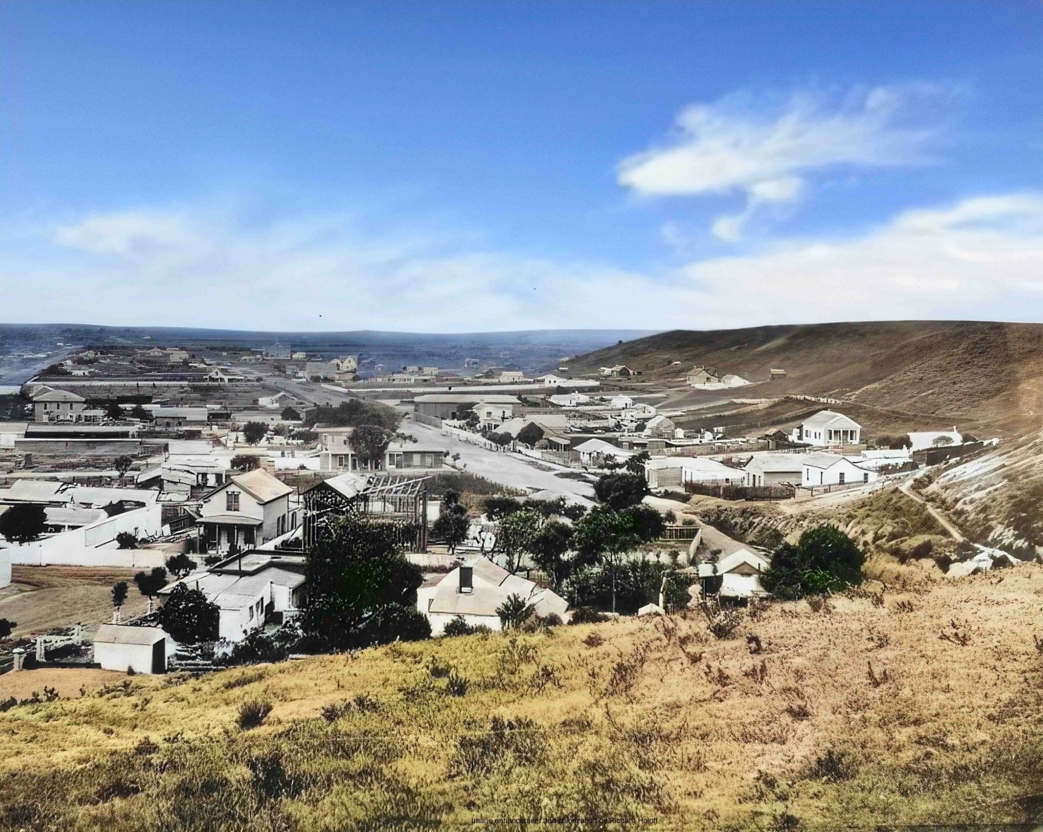 |
|
| (1868)* - View looking south from Poundcake Hill. Fort Street (later Broadway) runs diagonally through the center of the photograph, while Bunker Hill rises at right before the residential development that would soon transform its slopes. Image enhanced and colorized by Richard Holoff. |
Historical Notes This colorized version of the 1868 panorama, enhanced by Richard Holoff, offers a different perspective on early Los Angeles and helps bring the city's nineteenth century landscape to life. The view looks south across Fort Street (later Broadway) toward the largely undeveloped slopes of Bunker Hill at a time when Los Angeles remained a compact community of only a few thousand residents. While the colors are interpretive rather than historically documented, the image helps illustrate the openness of the landscape, the sparse development along the city's principal streets, and the dramatic changes that would reshape this area during the decades that followed. |
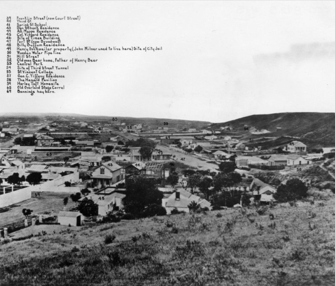 |
|
| (1868)* - Same photo as shown above but with buildings and key areas are identified by numbers (see below). |
Historical Notes This annotated version identifies many of the residences, institutions, streets, and landmarks visible in the panorama, providing a rare snapshot of Los Angeles during a period when much of the city could still be viewed from a single hilltop vantage point. #39 Franklin Street (now Court Street); #40 Third Street; #41 Spring Street School; #43 Dan Scheck residence; #44 A.G. Mappa residence; #45 Col. Vineyard residence; #46 Site of Times Building; #47 Fort Street (now Broadway); #48 Billy Buffum residence; #49 Henry Dockweiler property (John Milner used to live here), site of the city jail; #50 Wooden Water Pipeline; #51 Hill Street; #52 Old man Bear home, father of Henry Bear; #53 Central Park; #54 Site of Third Street Tunnel; #55 St. Vincent's College; #57 George C. Tiffany residence; #58 The Hazard's Pavilion; #59 Harley Taft home site; #65 Old Overland Stage Corral; #69 Banning’s Hay Barn. |
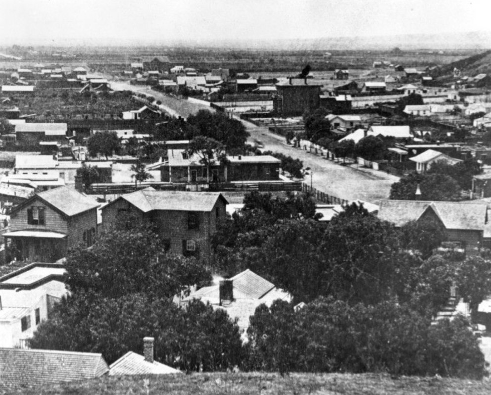 |
|
| (ca. 1870)* - View looking south along Fort Street (later Broadway) from near Temple Street. The large building at right is St. Vincent's College, one of the earliest institutions of higher learning in Southern California. |
Historical Notes The prominent structure visible at right is St. Vincent's College, founded in 1865 by the Vincentian Fathers. The institution played an important role in the educational development of early Los Angeles and became one of the city's best-known landmarks during the late nineteenth century. It remained an important educational institution in Los Angeles for many years. At the time this photograph was taken, Los Angeles had a population of approximately 5,730 residents. Fort Street remained a relatively modest corridor lined with residences, schools, churches, and small commercial establishments. Within a few decades, however, the street would be renamed Broadway and transformed into one of the busiest and most important thoroughfares in the city, reflecting the extraordinary growth that reshaped Los Angeles during the late nineteenth and early twentieth centuries. |
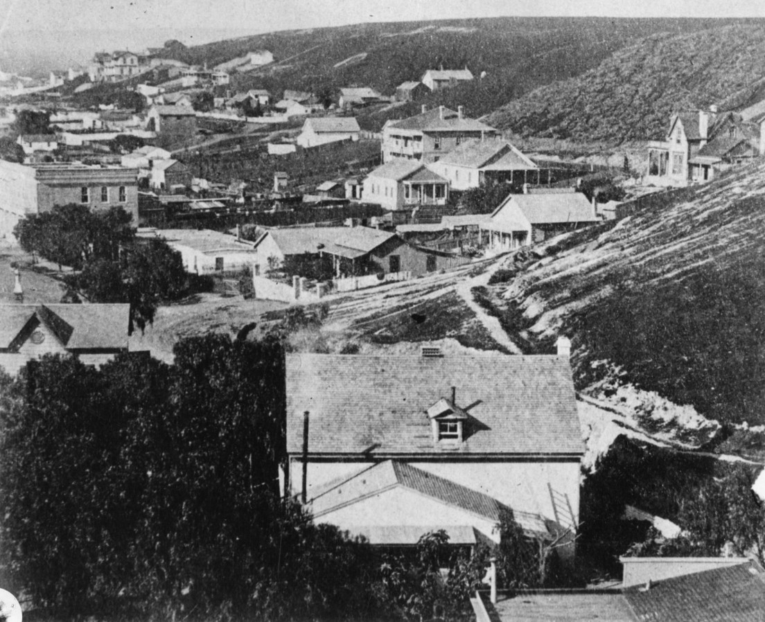 |
|
| (ca. 1870)* — View looking toward the residential slopes of Bunker Hill in early Los Angeles. The hillside shows substantial residential development, reflecting the period when Bunker Hill was emerging as one of the city's most desirable neighborhoods. This image has been dated elsewhere as 1860, although the extent of development visible on the hillside suggests it may have been photographed somewhat later, possibly during the late 1860s or early 1870s. Source: Los Angeles Public Library Photo Collection. |
| Historical Notes
By the late nineteenth century, Bunker Hill had begun its transformation from largely open land into one of Los Angeles' most prestigious residential districts. The elevated terrain, cooler breezes, and commanding views attracted both developers and homebuyers seeking an alternative to the crowded streets of the growing downtown area. The wood frame residences visible in this photograph represent some of the earliest stages of that development. Prudent Beaudry played a major role in promoting Bunker Hill during the late 1860s and 1870s, helping establish the neighborhood as a desirable residential enclave. The degree of development visible on the hillside in this photograph appears more consistent with that period than with the largely undeveloped Bunker Hill seen in other views from the 1860s. Regardless of the precise date, the image provides a valuable record of the neighborhood during its formative years, before the grand Victorian mansions that later came to define Bunker Hill began to dominate the landscape. |
* * * * * |
Spring and Court Streets |
During the 1870s, Spring Street and Court Street formed part of the growing commercial heart of Los Angeles. Located just south of the Plaza, these streets connected many of the city's most important businesses, professional offices, and public institutions. The views in this section capture a period when downtown Los Angeles was transitioning from a small frontier town into an organized commercial center, with new brick buildings, expanding retail activity, and increasing street traffic reflecting the city's rapid growth.Several landmarks visible in these photographs would become closely associated with Los Angeles' development during the late nineteenth century, including Temple Block, one of the city's most important commercial buildings, and the original Los Angeles High School on Poundcake Hill, one of the earliest public educational institutions in Southern California. |
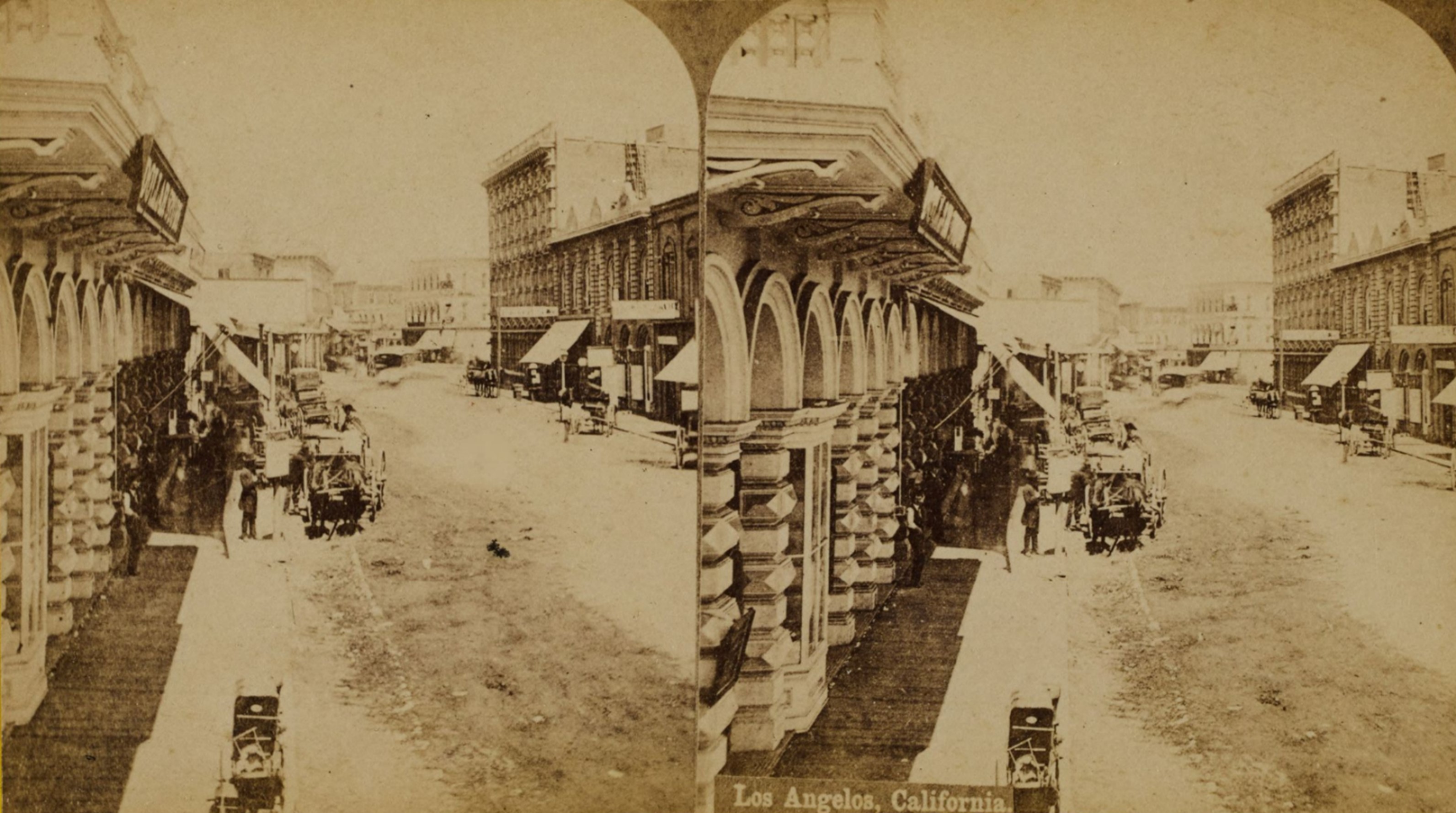 |
|
| (1870s)* – A stereoscopic view looking north along Spring Street near Court Street toward its intersection with Main Street in downtown Los Angeles. Horse-drawn wagons line the curb, and the three-story Italianate Temple Block rises in the center-right distance, where Spring and Main streets converged at Temple Street. Signs for a bookstore and a “Dollar Store” are visible in the left foreground, along with a baby carriage and a small toy cart. Photo from the Ernest Marquez Collection. |
Historical Notes This view captures Spring Street during the early stages of its transformation into one of Los Angeles' principal business corridors. Although still retaining the appearance of a small town, the street already displays many of the characteristics of a growing commercial district, including retail storefronts, professional offices, and a steady presence of wagons serving local merchants and residents. Dominating the distance is Temple Block, one of the most important commercial structures in nineteenth century Los Angeles. The complex was built in stages by F.P.F. Temple, who purchased the property in 1867. Two two-story brick additions were completed in 1868 and 1870, and a three-story Italianate structure followed in late 1871. That final building housed the Temple and Workman Bank on its ground floor — the city's most prominent financial institution until the bank's collapse during the economic panic of 1875. The block also contained law offices, professional suites, and a saloon in the basement. By the 1870s, the Temple Block was widely regarded as one of the most impressive commercial buildings in Los Angeles. The stereoscopic format of the photograph was especially popular during the nineteenth century. When viewed through a stereoscope, paired images created the illusion of depth, allowing viewers to experience city scenes in three dimensions. Such photographs were often collected as souvenirs and provided distant audiences with a vivid impression of life in rapidly growing communities such as Los Angeles. |
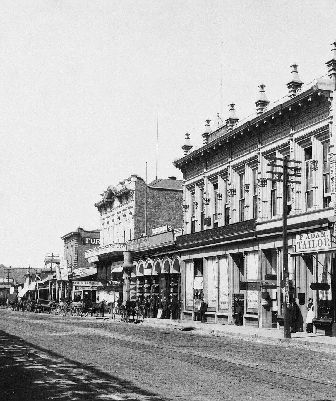 |
|
| (1875)^ - View of Spring Street near Court Street. On thie right is F. Adam, Tailor; and the top of the building has sign "City of Paris" Los Angeles High School sits on Poundcake Hill behind these buildings. |
Historical Notes In the 1870s, Spring Street in Los Angeles began to emerge as a key commercial thoroughfare, particularly between Court Street and Main Street. As part of the city's developing downtown, this stretch of Spring Street experienced notable growth and transformation during the period. Prominent landmarks included the Temple Block, constructed by F.P.F. Temple between 1868 and 1871 at the intersection of Spring, Main, and Temple streets. The Temple and Workman Bank, housed in the northernmost part of the Temple Block, marked the beginning of Spring Street's evolution into Los Angeles' financial hub. Additionally, John T. Sheward's store, one of the first businesses to open on Spring Street, symbolized its rise as a vital commercial center. |
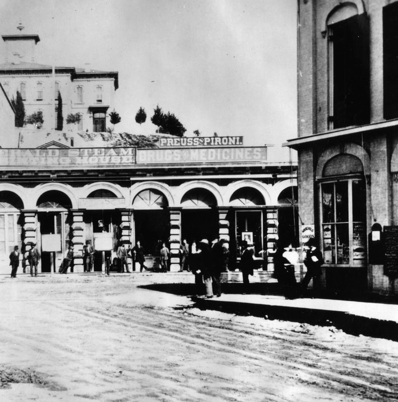 |
|
| (1875)* - View looking west along Court Street toward North Spring Street. Visible storefronts include the Herald Steam Printing House, which served as the office and press facility for the Los Angeles Daily Herald, and the Preuss & Pironi Drugs & Medicine store at 23 Spring Street. The original Los Angeles High School is visible on Poundcake Hill in the background. |
Historical Notes Court Street served as an important link between Spring Street's commercial district and the civic and educational institutions that occupied the higher ground to the west. Although less prominent than Spring or Main streets, Court Street supported a variety of businesses that catered to the daily needs of residents, including printers, merchants, and druggists. The Herald Steam Printing House, whose sign is visible in this view, was the office and production facility for the Los Angeles Daily Herald, which first published on October 2, 1873. The Herald was the first newspaper in Southern California to use a steam-powered press — a significant technological distinction in the 1870s. Its masthead consistently identified the paper's location as “Spring Street, opposite the Court House.” By 1875, the paper had passed from its founder, Charles Storke, to the Los Angeles City and County Printing and Publishing Company, with F.P.F. Temple serving as the company's treasurer. Next door, Preuss & Pironi operated a well-established pharmacy at 23 Spring Street. The firm advertised regularly in the Herald throughout the 1870s and 1880s, offering prescriptions, patent medicines, and health products. The Los Angeles High School building seen on Poundcake Hill above was new at the time of this photograph, having opened in 1873 as Southern California's first public high school. |
* * * * * |
While Los Angeles expanded inland through new streets, homes, commerce, and civic institutions, another transformation was taking place to the south. Along San Pedro Bay, a shallow coastal anchorage was gradually evolving into the gateway that would connect Los Angeles to the wider world and help propel the city into a new era of growth. |
Gateway to the Outside World: The Los Angeles Harbor |
Before Los Angeles had railroads, boulevards, or a skyline, it had the sea.San Pedro Bay served as the region's fragile lifeline — a shallow anchorage where goods and passengers often had to be ferried ashore by small boat or unloaded onto beached vessels. From these modest beginnings, a working harbor slowly took shape and, with it, the city grew.The photographs in this section span roughly three decades, from the 1870s into the late 1890s, capturing a port in transition. They show wharves and lumber stacks, schooners and railroad tracks, and the early communities that developed along the waterfront. Together they document the pivotal role San Pedro played as the point of entry for raw materials, commerce, and opportunity that helped transform Los Angeles into a major American city.No individual shaped that transformation more than Phineas Banning, whose dredging campaigns, railroad construction, and political advocacy earned him the title "Father of Los Angeles Harbor." Yet the harbor's story also belongs to the workers, merchants, sailors, freight operators, and waterfront businesses whose daily efforts turned the tidal flats of San Pedro Bay into one of the great seaports of the Pacific. |
 |
|
| (ca. 1876)* - Timms' Landing, San Pedro, looking toward the town from the waterfront. A flagpole stands near the center of the frame while small waterfront buildings line the shoreline. One structure displays a sign reading "Chandlery," and the early settlement of San Pedro appears in the canyon beyond. |
Historical Notes European awareness of San Pedro Bay dates to 1542, when Juan Rodríguez Cabrillo entered what he described as the "Bay of Smokes," likely referring to fires maintained by Indigenous communities along the coast. For centuries afterward, however, the harbor remained little more than an exposed anchorage where ships transferred cargo offshore rather than docking directly at the shoreline. That began to change in 1852 when Augustus W. Timms acquired the old Sepulveda Landing and expanded it into one of the area's first organized port facilities. He developed a wharf, warehouse, corral, hotel, and supporting businesses that served freight and passenger traffic between the harbor and Los Angeles. The surrounding area became known as Timms' Point and remained a familiar landmark for decades. Today the site is recognized as California Historical Landmark No. 384 and Los Angeles Historic Cultural Monument No. 171. The building labeled "Chandlery" was a marine supply store that provided ships with rope, rigging, tools, and other provisions needed for harbor operations. |
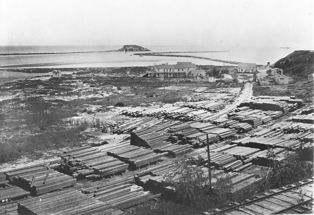 |
|
| (ca. 1876)* - View of San Pedro Harbor from Timms' Landing, looking southeast toward what later became Southern Pacific Slip (Berth 73). Deadman's Island appears in the distance while lumber stacks and rail activity occupy the foreground. |
Historical Notes This photograph captures San Pedro Harbor during a period when maritime commerce and rail transportation were beginning to operate as a single system. Visible in the distance is Deadman's Island, one of the harbor's most recognizable nineteenth century landmarks. Known variously as Dead Man's Island, Isla del Muerto, and Reservation Point, the rocky outcrop became part of local legend and later entered national attention during debates over Southern California's harbor future. The island itself did not survive the twentieth century. In 1928, harbor expansion projects removed Deadman's Island entirely, using the fill to enlarge nearby Terminal Island and create additional industrial waterfront. The lumber visible in the foreground hints at one of the industries that would help fuel Los Angeles' growth. |
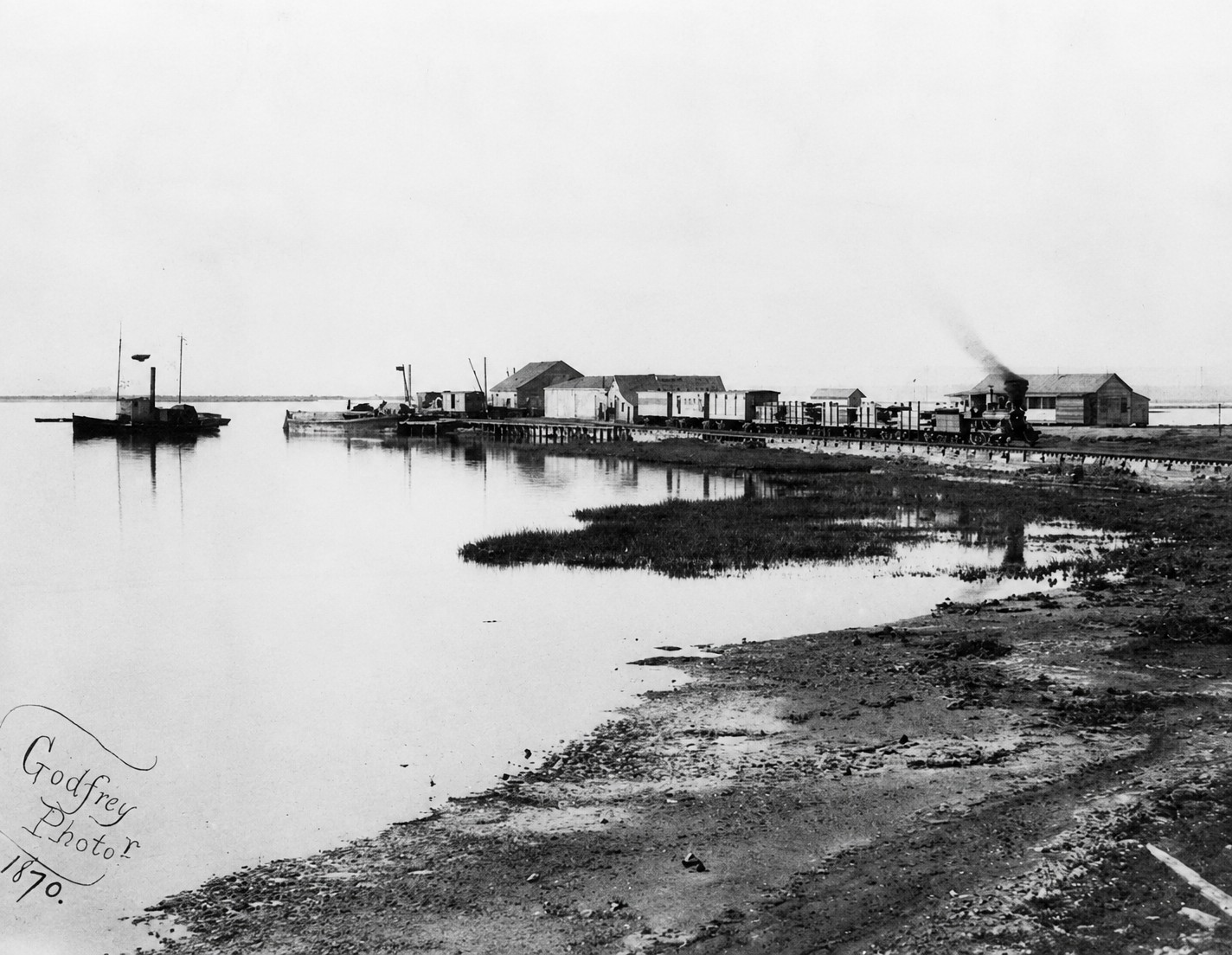 |
|
| (1870)* - Wilmington Harbor showing the Los Angeles and San Pedro Railroad shortly after completion in 1869 — the first railroad connection between Los Angeles and its harbor. |
Historical Notes Before rail service reached the harbor, freight moving between Los Angeles and San Pedro depended on ox carts and later horse drawn wagons. The journey was slow, expensive, and increasingly inadequate for a growing city. Recognizing that transportation would determine the harbor's future, Phineas Banning organized construction of the Los Angeles and San Pedro Railroad between 1868 and 1869, creating Southern California's first railroad line. The twenty one mile route dramatically reduced shipping costs and tied ocean commerce directly to inland markets. Banning later sold the railroad to Southern Pacific, but his larger effort continued. Through years of lobbying and investment, he helped secure federal support for harbor improvements and laid the foundation for what would become the Port of Los Angeles. |
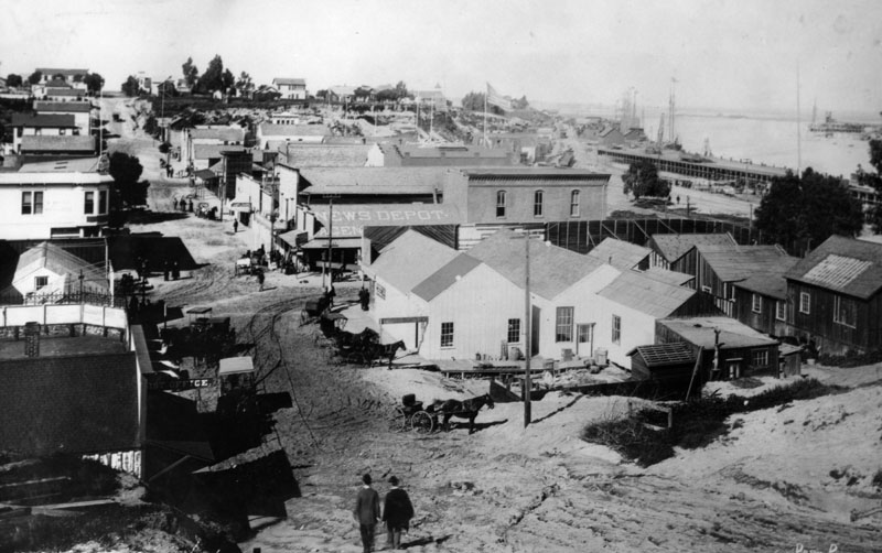 |
|
| (ca. 1880s)* - An unpaved road in San Pedro with horse drawn transportation in the foreground and the harbor visible in the distance. |
Historical Notes The 1880s brought rapid change to San Pedro and the Los Angeles region. New railroad connections, increasing migration, and rising construction activity placed growing pressure on the harbor to handle larger volumes of goods and materials. At the same time, debate intensified over where Southern California's principal deepwater harbor should be located. Competing interests promoted San Pedro and Santa Monica as rival sites. California Senator Stephen M. White became one of San Pedro's strongest advocates during the harbor debates, helping secure federal support for improvements. By the late 1890s, federal harbor decisions effectively established San Pedro Bay as Los Angeles' principal harbor, validating decades of local investment and setting the stage for future expansion. Scenes like this remind us that before breakwaters, cranes, and container terminals, San Pedro was still a small coastal community gradually growing into something much larger. |
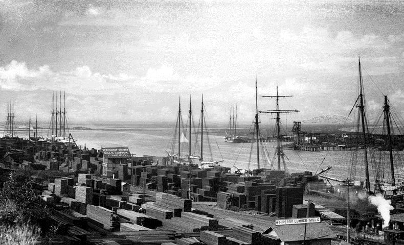 |
|
| (ca. 1889)* - The San Pedro Inner Harbor with cargo vessels unloading lumber. The W.H. Perry Lumber Mill Company and the Kerckhoff-Cuzner Mill and Lumber Company are visible along the waterfront. |
Historical Notes Few industries shaped nineteenth century Los Angeles more directly than lumber. During the great building boom of the late 1880s, enormous quantities of timber arrived from Northern California and the Pacific Northwest. Harbor records indicate that more than twenty five million board feet of lumber passed through San Pedro during only two months in 1887. Operations visible in this photograph processed and distributed that material throughout Southern California. The harbor did not merely support growth. It physically built Los Angeles. |
 |
|
| (ca. 1899)* - View of the Inner Harbor and Terminal Island with lumber stored along both sides of the channel and railroad tracks extending through the foreground. |
| Historical Notes
By the closing years of the nineteenth century, ship and rail had become fully integrated at San Pedro Harbor. Cargo could move directly from vessel to railcar, reducing labor, lowering costs, and dramatically increasing efficiency. The transportation system visible here connected Los Angeles to broader Pacific trade networks and accelerated regional growth. Terminal Island, visible across the channel, had recently replaced the earlier name Rattlesnake Island and would continue expanding through later harbor development projects to become one of the industrial centers of the modern port. |
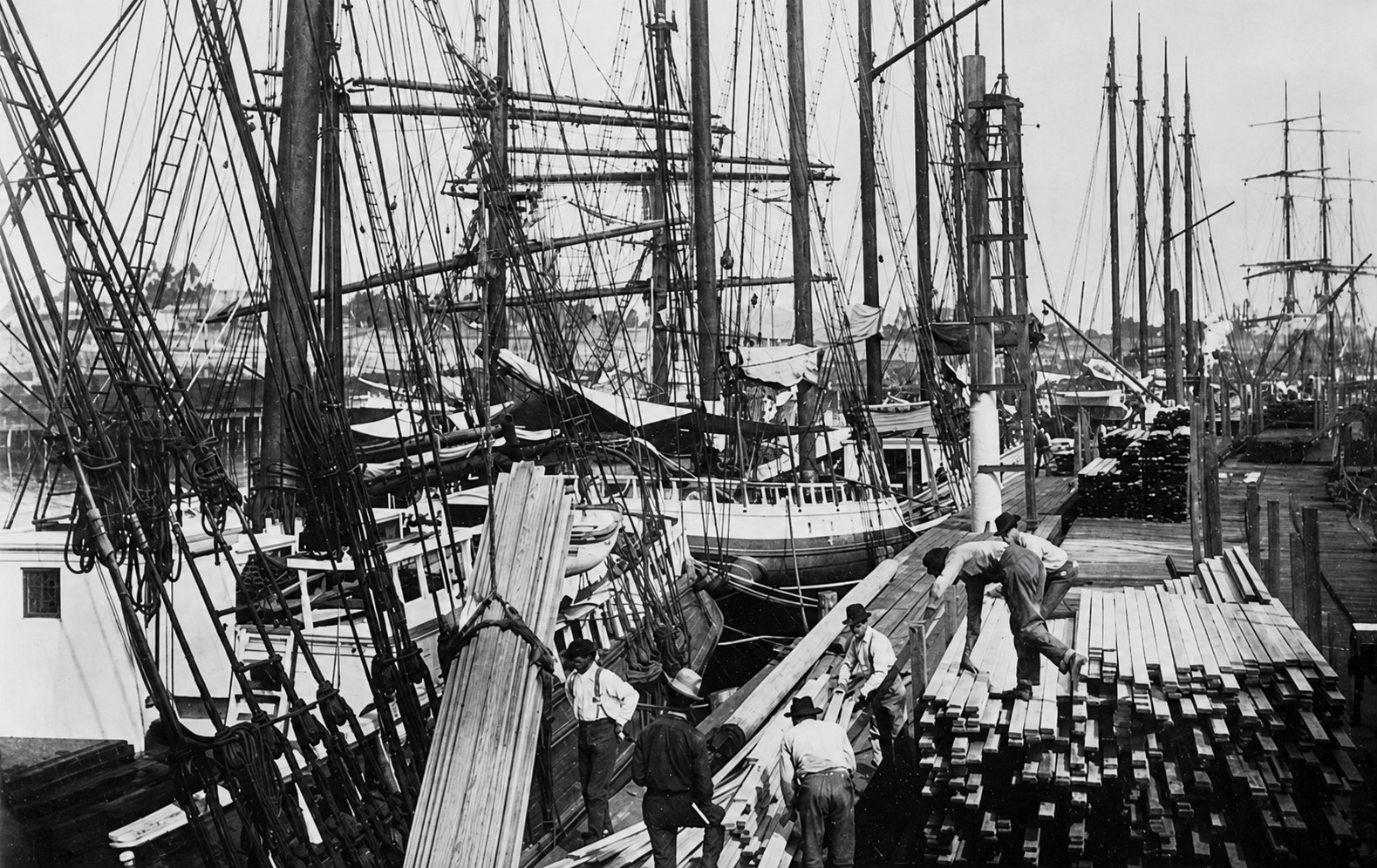 |
|
| (ca. 1896)* - Workers unloading lumber at San Pedro Harbor while ships remain moored along the dock. |
| Historical Notes
The workers shown here represent the human side of Los Angeles' growth. For decades, harbor labor supported construction across Southern California by unloading, processing, transporting, and distributing the materials that built neighborhoods, commercial districts, railroads, and public infrastructure. Although the harbor would later diversify into oil, manufacturing, and global shipping, these early waterfront operations established the pattern that still defines the port today. Today, the Port of Los Angeles remains the busiest container port in the United States — a direct descendant of the shallow anchorage seen in these earliest photographs. Click HERE to continue exploring the story in Early Views of San Pedro and Wilmington. |
Research, writing, and image curation by Jack Feldman, Water and Power Associates, with editorial assistance.
* * * * * |
More Historical Early Views
Newest Additions
Early LA Buildings and City Views
History of Water and Electricity in Los Angeles
* * * * * |
References and Credits
* DWP - LA Public Library Image Archive
^ LA Public Library Image Archive
*# Publications of the Historical Society of Southern California, Volume 9: Eternity Street
#* OUTPOST – Preserving Historical Data by W. S. Broke
#^ Huntington Digital Library Archive
+^ Old Los Angeles and Environs blogspot
*+ The Jews of Los Angeles: Urban Pioneers
++ Vigilantism in Los Angeles (1853 - 1874)
^**UCLA-DWP Library Collection: Map of the City of Los Angeles as it Appeared in 1850
***Los Angeles Historic - Cultural Monuments Listing
*^*California Historical Landmarks Listing (Los Angeles)
*^#Public Art in LA: Campo Santo
^^#CSULB - A Visit to Old LA: Main Street
*##Metro.net - Los Angeles Transit History
^##California State Library Image Archive
**#The Cable-Car-Guy.com: The Los Angeles Railway
*#*KCET - Inventing LA: Port of Los Angeles; A Brief History of LA Bridges; LA's First Streetcars
**^History Matters: Calle de los Negros, 1880s
^^*LA Fire Department Historical Archive
^*#Noirish Los Angeles - forum.skyscraperpage.com
^#^Historic Hotels of Los Angeles and Hollywood (USC - California Historic Society): Bella Union Hotel; Lafayette Hotel
#^*Flickr.com: Michael Ryerson
#++Facebook.com: Garden of Allah Novels, Martin Turnbull
*^^Los Angeles Magazine: Zanja Madre 1868
*^*^Wilmington Historic Society
**^^Boyle Heights History Timeline
*#^^LAPL-El Pueblo de Los Angeles Historical Monument Photo Archive
*^^#Boyle Heights History Blog
^#**Santa Monica History Museum
^#*^ElPueblo.lacity.org: Plaza Map
^##^El Pueblo de Los Angeles Historical Monuments Listing
^*^*KCET - El Aliso: Ancient Sycamore Was Silent Witness to Four Centuries of L.A. History
#**^LA County Library Image Archive
#*#^LAPL-El Pueblo de Los Angeles Historical Monument Photo Archive
#^#^Chinese Los Angeles in 1870-1871 - Scott Zesch
#^*^Calisphere: University of California Image Archive
#^#*Picture Gallery of Los Angeles History
*^ Wikipedia: Arcadia Bandini de Stearns Baker; Bunker Hill; Prudent Beaudry; Jonathan Temple; Los Angeles High School; Joseph Widney; Pershing Square; Port of Los Angeles; Belmont High School; Hollenbeck Park; Ducommun; Isaias W. Hellman; Abel Stearns; Sawtelle Veterans Home; Arcade Station; Alhambra; Fort Moore; History of Santa Monica; History of Los Angeles; Burbank; Los Angeles and Independence Railroad; Phineas Banning; History of Los Angeles Population Growth; Ozro W. Childs; The Church of Our Lady the Queen of Angels; Fort Moore; Santa Catalina Island; San Fernando Valley; Chinese Massacre of 1871; The Church of Our Lady the Queen of Angels
TEST TEXT
< Back