Early Views of Commercial Street |
(The Forgotten Commercial Core of Early Los Angeles) |
Introduction |
Commercial Street was the beating commercial heart of early Los Angeles. Running east from Main Street, with its densest commercial activity concentrated in the first block to Los Angeles Street, this compact corridor packed more economic ambition into a few hundred feet than any other address in the young pueblo. By the late 1860s it was lined with dry goods emporiums, hardware merchants, saddlers, banks, hotels, and general suppliers, and its two-story brick buildings, unusual in a city still largely built of sun-dried adobe, announced that Los Angeles was beginning to trade its Mexican-era past for an American commercial future.
|
In This Section |
* * * * * |
ERA 1 — The Business District at Its Peak (1869–1882) |
During the late nineteenth century, Commercial Street emerged as the undisputed business center of Los Angeles. Although little more than a single block between Main and Los Angeles streets, the corridor concentrated much of the city’s early commercial activity within a remarkably compact space. Dry goods stores, hardware merchants, saddle makers, hotels, printers, banks, and professional offices lined the unpaved roadway, while horse-drawn wagons and pedestrians crowded the street from morning until evening.The district reflected Los Angeles during a pivotal moment of transition. Adobe structures still dominated much of the city, yet Commercial Street increasingly featured brick commercial buildings that symbolized permanence and commercial ambition. Men like Isaias W. Hellman, Charles Ducommun, F.P.F. Temple, Solomon Lazard, and Samuel Prager established businesses here that helped shape the future financial and commercial development of Los Angeles. Gas streetlamps illuminated portions of the district by the late 1860s, introducing one of the city’s earliest forms of modern urban infrastructure.The photographs in this section, taken between 1869 and around 1900, preserve the most complete visual record of Commercial Street during its formative years and commercial peak. They capture a city still small enough for merchants to know one another personally, yet already beginning to grow beyond its frontier origins into a larger American metropolis. |
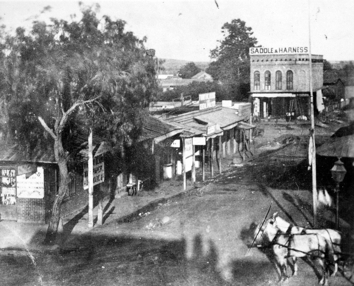
Looking east down Commercial Street on a quiet day in 1869, this remarkable view captures Los Angeles at the precise moment it was reinventing itself as a commercial city. Adobe Los Angeles was beginning to give way to a more ambitious urban future built of brick storefronts, expanding businesses, and growing financial institutions. |
 |
|
| (1869)* - Early view of Commercial Street, looking east from Main Street, just north of Temple Street, near the site of the later City Hall. On the right is Polaski and Goodwin's Dry Goods Store, sold to them by I.W. Hellman in 1868, and where the Farmers and Merchants Bank would later do business for years. Charles Ducommun operated a combined jewelry and hardware store in the building at left foreground. In the background stands Herman Heinsch's Saddle and Harness shop, a newly erected brick building. At lower right, one of Los Angeles's first gas streetlamps is visible, part of the forty-three lamps installed along Main Street in 1867 by the Los Angeles Gas Company. |
| Historical Notes
This view looking east from Main Street shows Commercial Street at the height of its influence as Los Angeles's principal business district. The block between Main and Los Angeles streets was the economic nerve center of the city in the late 1860s, bounded to the north by Calle de los Negros and to the south by nearby Aliso and Arcadia streets. Most structures in Los Angeles at this time were still built of sun-dried adobe, twenty inches long, fourteen inches wide, and five inches thick, making the brick buildings visible here, including Heinsch's saddle shop in the background, conspicuous markers of a new commercial ambition. I.W. Hellman purchased the dry goods store at this corner from Adolph Portugal in 1865 at the age of twenty-two and quickly became one of the most trusted merchants in the city. Customers left their gold dust and valuables in his safe as a courtesy, and Hellman soon formalized the arrangement with printed deposit slips, effectively becoming Los Angeles's first unofficial banker. In 1868 he formalized the operation as Hellman, Temple and Company, and in 1871 founded the Farmers and Merchants Bank, Los Angeles's first successful formal banking institution. Herman Heinsch's saddle shop in the background is a reminder that horses still powered nearly every aspect of transportation and commerce in 1869, and that Commercial Street served the full range of a working frontier economy. |
The same vantage point and the same year, but this second exposure calls attention to a detail easy to overlook. The gas streetlamp at lower right was one of forty-three installed along Main Street just two years earlier. |
 |
|
| (1869)* - A second 1869 exposure of Commercial Street, looking east from Main Street, captures the same scene with the gas streetlamp at lower right shown more clearly. On the right is Polaski and Goodwin's Dry Goods Store, formerly Hellman's store, sold in 1868, where the Farmers and Merchants Bank would later maintain its business for years. Charles Ducommun's jewelry and hardware store occupies the building at left foreground, and Herman Heinsch's Saddle and Harness shop rises in the background. The lamp at lower right is one of the forty-three gas streetlamps installed along Main Street on June 28, 1867, by the newly franchised Los Angeles Gas Company, the first gas street lighting system in Southern California. |
| Historical Notes
Charles Louis Ducommun was born in Switzerland and trained as a watchmaker. Drawn westward by the California Gold Rush, he made a grueling nine-month journey from Arkansas to California, partially on foot and despite having lost sight in one eye from smallpox. Arriving in Los Angeles when the pueblo had fewer than 1,600 residents, he opened a small watch repair shop and quickly expanded into hardware, mining supplies, and general merchandise. His clocks and meteorological instruments kept the city's official time and weather records for many years. The gas streetlamp visible at lower right represents a major milestone in Los Angeles history. On June 28, 1867, the Los Angeles Gas Company, the forerunner of today's Southern California Gas Company, installed forty-three gas lamps along Main Street, marking the arrival of gas street lighting in Southern California. The gas was initially manufactured locally from asphalt and later from oil. Each evening a lamplighter on horseback traveled from lamp to lamp igniting the flames by hand. By 1873 more than 130 gas lamps illuminated the compact downtown district before electric arc lighting gradually replaced them in the early 1880s. Click HERE to see more in Early Los Angels Streetlights. |
A map detail, highlighted to orient the viewer, places Commercial Street within the compact grid of early downtown Los Angeles and shows the eastward direction of the previous photographs. |
 |
|
| Map detail showing the camera location and direction looking east from Main Street down Commercial Street toward Los Angeles Street. Although the street extended further east toward Alameda Street and the Los Angeles River, its densest commercial activity during the late 1860s was concentrated in this first block, little more than 300 feet in length. |
| Historical Notes
Not surprisingly, Commercial Street is much changed from what it was more than 150 years ago. The stretch shown in these early photographs disappeared long ago, as the section from Main Street to Alameda Street became occupied by commercial and government buildings, including the regional office of the Internal Revenue Service, the Edward R. Roybal Federal Building, and the Metropolitan Detention Center. What remains today are several blocks paralleling the 101 Freeway, constructed through the area during the 1950s, extending east from Alameda Street to the Los Angeles River. A short stretch of East Commercial Street still survives between Alameda Street and the river, where parking structures and commercial buildings line what has become a largely overlooked roadway. Nearby, the Metro Gold Line crosses Alameda Street south of Union Station before continuing east toward Boyle Heights and East Los Angeles. Just north of the Commercial Street business district was Calle de los Negros, one of the most infamous alleys in early Los Angeles. Running north from Aliso Street toward the Plaza, it became the site of the 1871 Chinese Massacre, the deadliest mass lynching of Chinese immigrants in American history. The tragedy served as a stark reminder that the same streets fueling Los Angeles’s early commercial growth also witnessed some of the darkest episodes in the city’s history. The alley later disappeared during the widening of Los Angeles Street and subsequent redevelopment projects. |
By around 1870, Commercial Street had acquired one of its most commanding landmarks on the north side. The two-story brick building erected by I.W. Hellman reflected the growing scale, confidence, and permanence of Los Angeles's emerging business district. |
 |
|
| (ca. 1870)* - View of Commercial Street, looking east from Main Street. The two-story White House Hotel is visible at far right on the southeast corner of Commercial and Los Angeles streets. At left is the two-story brick building erected by I.W. Hellman in 1870, among the first structures of that height built in Los Angeles, with Ducommun Hardware occupying the prominent corner at left foreground. Horse-drawn carriages move along the unpaved roadway. This was the undisputed business center of Los Angeles at the time. |
| Historical Notes
Isaias Wolf Hellman was born in Reckendorf, Bavaria, in 1842 and arrived in Los Angeles in 1859. After opening his own dry goods store in 1865, he quickly emerged as one of the city's most influential businessmen. His two-story brick building erected here in 1870 was both practical and symbolic, signaling permanence at a time when much of Los Angeles still consisted of adobe structures. Hellman later helped finance the Los Angeles Railway and the Pacific Electric Railway with Henry Huntington, helped establish the University of Southern California alongside Ozro W. Childs and former Governor John G. Downey, and served as a regent of the University of California for nearly four decades. The White House Hotel at the southeast corner of Commercial and Los Angeles streets catered primarily to merchants, ranchers, lawyers, and travelers arriving in the city by stagecoach years before rail service reached Los Angeles in 1876. Hotels of this period were modest frontier establishments, but their locations were important gathering places for business and civic activity. As Los Angeles expanded during the great railroad and real estate boom of the 1880s, larger and more elaborate hotels gradually replaced the smaller hostelries of the pueblo era. |
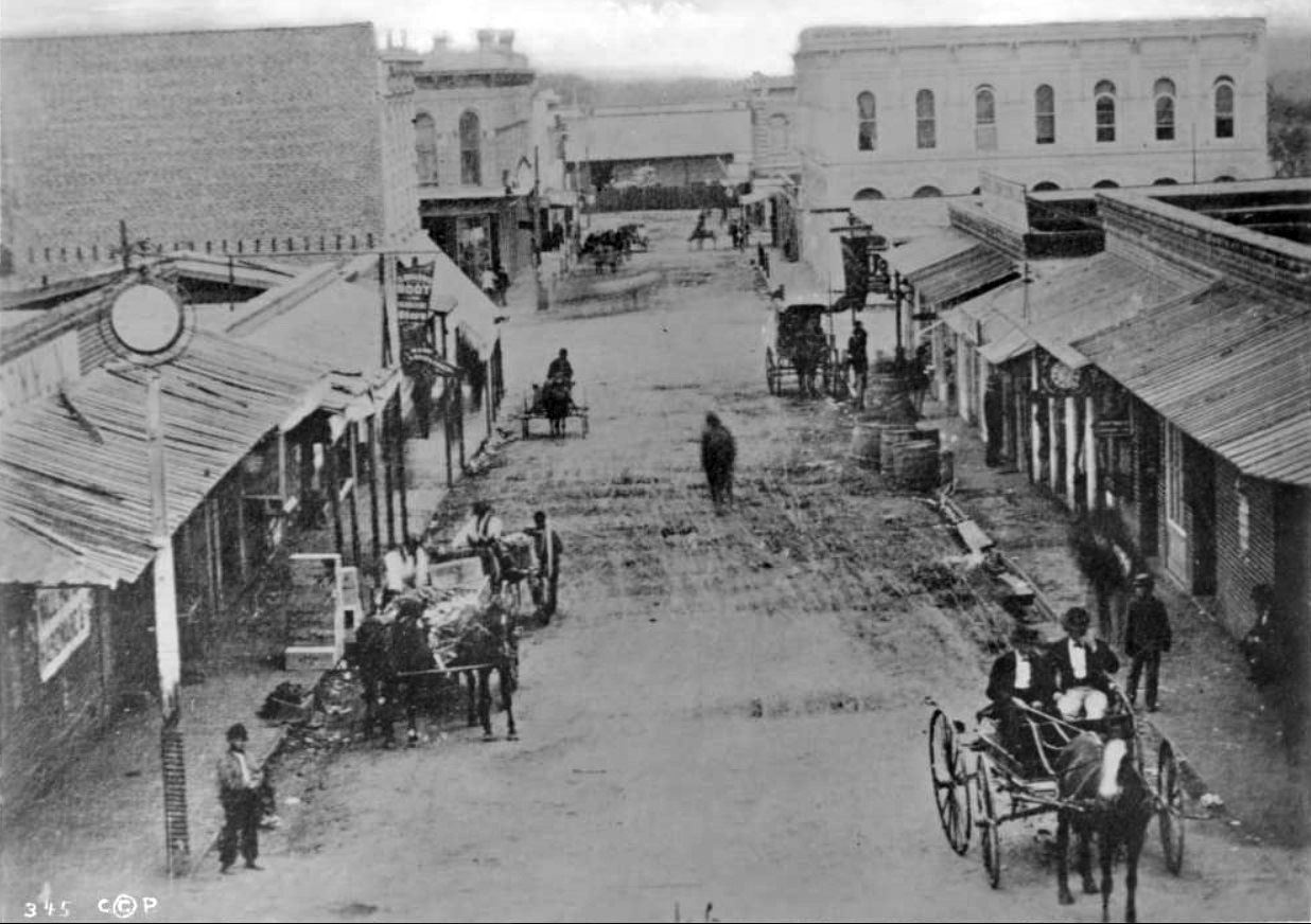
William M. Godfrey's 1872 stereoscopic photograph captures the energy of Commercial Street in a single frame, with every storefront representing a different enterprise and every sign advertising a different owner |
 |
|
| (1872)* - Stereoscopic photograph showing Commercial Street looking east from Main Street, taken by William M. Godfrey from a position just north of Temple Street and F.P.F. Temple's Temple Block. Ducommun's hardware and jewelry store occupies the left foreground, with Polaski and Goodwin's dry goods store at right. The street, sometimes called "New Commercial Street" in period sources, was devoted almost entirely to commerce for the length of this view. Photo by William M. Godfrey, Homestead Collection. |
| Historical Notes
Francis Pliny Fisk Temple, better known as F.P.F. Temple, arrived in Los Angeles from Massachusetts in 1841 and eventually became one of the city's leading businessmen and civic figures. He served as Los Angeles's second treasurer in 1851 and as a founding member of the first Los Angeles County Board of Supervisors the following year. His Temple Block, located at the intersection of Main, Spring, and Temple streets, became one of the most important commercial complexes in early Los Angeles. By the mid-1870s Temple ranked among the wealthiest men in Southern California, with investments in banking, ranching, oil, real estate, and water development. The collapse of the Temple and Workman Bank in 1875, however, destroyed much of his fortune and marked the end of an era for many of the city's early pioneer businessmen. William M. Godfrey operated one of Los Angeles's earliest photography studios during the 1870s, known as the Sunbeam Gallery, which he later sold to photographer Henry T. Payne. Many of Godfrey's views were subsequently reissued under Payne's name, creating occasional confusion in later image attributions. The stereoscopic format used here, twin photographs mounted side by side to create a three-dimensional effect when viewed through a stereoscope, was enormously popular during the nineteenth century. Godfrey's Commercial Street views, taken during Los Angeles's first sustained growth period after the Civil War, remain among the finest surviving visual documents of the city's transition from frontier pueblo to emerging commercial center. |
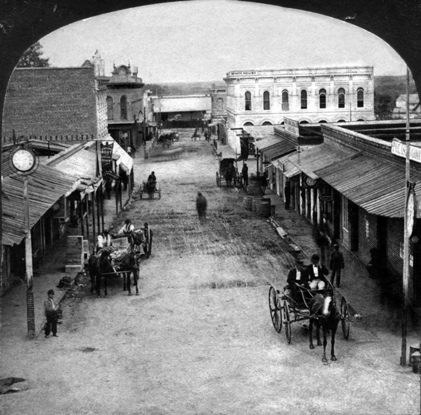
By 1880, Commercial Street had grown upward as well as outward. Samuel Prager's new three-story furniture and dry goods building on the north side of the street was the tallest structure the old business block had yet seen, a sign that the city's first commercial district still had ambitions of its own even as downtown began to shift southward. |
 |
|
| (1880)* - Stereograph view of Commercial Street looking east from North Main Street. At left is Samuel Prager's three-story furniture and dry goods building, one of the tallest structures on the street at the time. The White House Hotel is visible at far right in the distance. Horse-drawn wagons move along the unpaved roadway. By this date the street had been active as Los Angeles's commercial core for more than a decade. |
| Historical Notes
Samuel Prager was born in Prussia in 1831 and arrived in Los Angeles in 1854 after working with his brother Charles in Grass Valley during the Gold Rush years. In Los Angeles he established a dry goods and furniture business that grew steadily through the 1860s and 1870s, eventually occupying one of the most prominent storefronts on Commercial Street. In 1867 he became one of the first merchants in the city to deal in oil. Active in civic affairs throughout his life, Prager served as a member of Masonic Lodge 42 and as chairman of its Board of Relief for more than four decades. He was known throughout the city simply as "Uncle Sam" and died in 1907 after more than fifty years as one of Los Angeles's most respected merchants. The three-story scale of Prager's building reflects Los Angeles's first sustained real estate and commercial boom, which ran roughly from the late 1860s through the mid-1870s before a brief contraction. By 1880 the city was rebuilding confidence ahead of the much larger railroad-driven boom of the 1880s, which would bring the Southern Pacific and Santa Fe into direct competition, drop passenger fares to as little as one dollar from Kansas City, and trigger an explosion of real estate speculation and population growth that would permanently transform Commercial Street's relationship to the wider downtown. The businesses still operating here in 1880 were prospering, but the center of gravity was already beginning to shift south and west toward Spring Street and Broadway. |
By 1882, the northeast corner of Main and Commercial streets had become dominated by Charles Ducommun's expanding hardware business, a visible measure of how dramatically the enterprise had grown since its beginnings as a modest watch repair shop. |
 |
|
| (ca.1882)* - View of the northeast corner of Main and Commercial streets, showing the Hardware Store of C. Ducommun alongside S. Prager's dry goods store and a furniture store at 204 North Main Street, later renumbered 304 North Main Street after 1890. The expanded commercial frontage reflects the remarkable growth of Ducommun's enterprise from its origins as a one-room watch repair shop established during the Gold Rush era. |
| Historical Notes
Charles Ducommun died in 1896, leaving the business to his sons, who incorporated it in 1907 as the Ducommun Hardware Company. Over time the firm evolved from a local hardware supplier into a major industrial materials company serving Southern California's growing oil, agricultural, aviation, and manufacturing industries. Ducommun sheet metal was later used in the construction of the Spirit of St. Louis in 1927, and during World War II the company supplied both the aviation and shipbuilding industries. Today Ducommun Incorporated remains one of the oldest continuously operating companies founded in California. Samuel Prager's dry goods store, visible near the corner, represented part of the broader network of German and Central European Jewish merchants who played an essential role in shaping Los Angeles's early commercial economy. Like Hellman and Ducommun, these merchants often extended credit to ranchers and farmers, financed early civic improvements, and helped bring a sense of permanence and stability to the growing city. Within only a few years, however, the great railroad boom of the 1880s would transform Los Angeles on a much larger scale, shifting the commercial center farther south and west and gradually leaving behind the intimate pueblo-era business district seen in these photographs. Click HERE to see more on the Ducommun Building. |
* * * * * |
ERA 2 — Growth and Transformation Along Commercial Street (c. 1880–1900) |
By the turn of the twentieth century, Commercial Street had aged gracefully, though the center of the city's business district had long since shifted elsewhere. During the 1880s and 1890s, the city's commercial center steadily moved southward and westward, first toward First and Spring streets and later along Broadway as large department stores, office buildings, and banks followed the expanding population. Commercial Street's remaining active block between Main and Los Angeles streets still functioned, but it increasingly served a neighborhood economy rather than the broader commercial life of the city — a district of modest tenants, aging brick buildings, and businesses that reflected an earlier era of Los Angeles.The street nevertheless remained an important physical reminder of the city's formative years. Many of the merchants, bankers, and professionals who helped build early Los Angeles had once operated here, and several of the district's older brick commercial buildings still survived into the early twentieth century. These photographs capture Commercial Street during a transitional period when traces of the city's early commercial district still lingered beside a rapidly modernizing downtown. |
Older brick commercial buildings like the Hellman Building continued to line Commercial Street around the turn of the twentieth century, preserving visible connections to the merchants, bankers, and professionals who helped shape early Los Angeles during the city's formative decades. |
 |
|
| (ca. 1900)* – View looking west on Commercial Street from Los Angeles Street toward Main Street. The Hellman Building appears at right, one of the earliest surviving commercial blocks associated with Los Angeles's early merchant and banking community. Although Commercial Street remained active at the turn of the century, much of the city's commercial growth had already shifted farther south and west into newer downtown business districts. Photo from the Ernest Marquez Collection. |
| Historical Notes
Isaias Wolf Hellman arrived in Los Angeles in 1859 as a teenager from Bavaria and went to work in a cousin's dry goods store before opening his own business on Commercial Street. The informal banking service he offered customers — allowing them to store gold and valuables in his safe — gradually evolved into a formal banking career that would eventually make him one of the most influential financiers in Southern California. He co-founded Farmers and Merchants Bank in 1871, the first incorporated bank in Los Angeles, which later moved its headquarters to Main and Commercial streets in 1883 and operated there for more than two decades. By 1900, when this photograph was taken, Hellman himself had relocated to San Francisco, where he helped reorganize the failing Nevada Bank through a merger with Wells Fargo. The building he erected on this corner thirty years earlier remained as a visible artifact of the Commercial Street that launched his remarkable career. Among the notable tenants the Hellman Building housed during its early decades was Ezra F. Kysor, believed to be the first professional architect to practice in Southern California. Kysor arrived in Los Angeles around 1868 and went on to design some of the city's most important early landmarks, including the Pico House hotel, St. Vibiana Cathedral, Widney Hall at USC, and the original Farmers and Merchants Bank building. His office in the Hellman Building placed him at the center of a rapidly growing city he helped shape in brick and stone. By 1900, the building's ground-floor tenants had changed many times, but the two-story brick facade facing Commercial Street still appeared much as it had during the street's commercial peak years — a surviving remnant of the compact, walkable downtown Los Angeles that existed before the city's long expansion southward. |
* * * * * |
ERA 3 — Decline and Disappearance of Commercial Street (c. 1900–1950s) |
By the early twentieth century, Commercial Street had been overtaken by the city it helped create. The commercial energy that once made this single block the economic nerve center of Los Angeles had long since migrated southward and westward, pulled first toward Spring Street and then along Broadway as department stores, office towers, and financial institutions followed the expanding population. What remained on Commercial Street after 1900 was a district in gradual retreat — older brick buildings still standing, but filling with successively more modest tenants as the decades passed. Wholesale dealers, small hotels, storage operations, light industrial suppliers, and working-class restaurants replaced the dry goods merchants and bankers of the founding era.The neighborhood's demographic character shifted as well. The French immigrant community that had given the eastern blocks their distinctive identity in the late nineteenth century — and that would eventually produce Taix French Restaurant at 321 Commercial Street — gave way to successive waves of new arrivals as Chinatown and Little Tokyo took shape in the surrounding streets. Through the 1920s and 1930s the older brick buildings continued to stand, outlasting the era that built them, occupied but no longer prosperous. By the time photographer Arnold Hylen began systematically documenting the district around 1950, Commercial Street had the character of a neighborhood that had already accepted its own ending. The 101 Freeway was under construction to the north, federal building projects were advancing from the west, and the Civic Center expansion that would eventually erase most of the original street was already underway. Hylen and fellow photographer Palmer Conner left behind the most complete visual record of Commercial Street in its final years — photographs that are not merely records of a living street, but documents of disappearance. |
By 1950, the Ducommun Block at the corner of Main and Commercial streets still presented an active commercial face to the street, but the tenants occupying its ground floor — a modest hotel, a photo studio, a bank branch, a donut shop — bore little resemblance to the banking and mercantile ambitions that had built the corner eighty years earlier. |
 |
|
| (1950)* – View of the Ducommun Block at the northeast corner of Main and Commercial streets, showing the Federal Hotel, Federal Photo Studio, Security First National Bank, and the Donut King restaurant at left. An elderly woman is seated on a marble bench in the foreground. Photo by Arnold Hylen. |
| Historical Notes
The Ducommun Block had occupied the northeast corner of Main and Commercial streets since Charles Ducommun expanded his hardware operation in the early 1880s, making it one of the longest-surviving commercial addresses from the street's founding era. By 1950 its ground-floor tenants reflected eighty years of gradual transition from wholesale commerce to neighborhood service economy. The marble bench in the foreground, where an elderly woman sits in Hylen's photograph, suggests a street still used by local residents going about daily routines rather than merchants and bankers conducting the business of a growing city. Security First National Bank's presence on this corner in 1950 carried a faint echo of the financial history that had always defined the intersection. The original Farmers and Merchants Bank, co-founded by Isaias Hellman in 1871, had operated just steps away for more than two decades before the city's financial center migrated southward toward Spring Street. That a bank branch still occupied the corner in 1950 was less a sign of continuity than a measure of how thoroughly the neighborhood had been left behind — a single branch serving a diminished district while the city's real financial activity happened elsewhere. None of the buildings visible here survive today. |
A second Hylen view from the same year looks northeast from Main Street, showing the Ducommun Block from the street's approach and the corner where Commercial Street begins its brief eastward run toward a neighborhood already in its final years. |
 |
|
| (ca.1950)* - Main Street looking northeast toward Commercial Street, with the Ducommun Block and Security First National Bank on the corner. Photo by Arnold Hylen. |
| Historical Notes
This view from Main Street captures the Ducommun Block as a pedestrian approaching from the south would have seen it in 1950 — a solid brick corner building, well worn but still standing, its Victorian-era construction outlasting the commercial world that had built it by several decades. The intersection of Main and Commercial streets had seen more than eighty years of continuous activity by the time Hylen photographed it, from Hellman's original dry goods store through Ducommun's hardware expansion and into the modest retail and banking uses of the mid-twentieth century. The durability of the original brick construction is itself a kind of historical record — these buildings were built to last, by merchants who intended to stay. What the photograph cannot show is the pressure already closing in from every direction. The 101 Freeway was under construction to the north along the old Aliso Street corridor. The federal building program was expanding steadily westward from Los Angeles Street. The Civic Center complex that had been growing since the completion of City Hall in 1928 was pressing into the surrounding blocks with increasing urgency. Within a few years of this photograph both buildings visible here would be gone, and the intersection itself would cease to exist in any recognizable form. |
The northwest corner of Los Angeles and Commercial streets in 1950, where the Italian Kitchen occupied the ground floor of one of the neighborhood's surviving brick commercial buildings — a small restaurant serving a neighborhood that was itself slowly disappearing. |
 |
|
| (1950)* – View of the northwest corner of Los Angeles and Commercial streets, showing a two-story brick building with the Italian Kitchen restaurant on the ground level. Photo by Arnold Hylen. |
| Historical Notes
The Italian Kitchen's presence at this corner in 1950 reflects the layered demographic history of the blocks surrounding Commercial Street. The neighborhood had been home to a substantial French immigrant community in the late nineteenth century, and the streets east of Los Angeles Street had also developed strong Italian and Chinese communities over the following decades as successive waves of new residents settled near the downtown core. By 1950 the area was transitioning again, caught between the expanding Chinatown to the north, Little Tokyo to the east, and the advancing federal presence from the west. Small restaurants like the Italian Kitchen served the daily needs of whoever remained. The two-story brick building itself likely dated from the 1880s or 1890s, one of many such structures that had outlasted their original tenants by accommodating successive generations of small businesses. The cleared land visible in the background would later become the site of the 300 North Los Angeles Street Federal Building, completed in 1965. The Italian Kitchen left no further trace in the historical record after this image, one of dozens of small neighborhood restaurants that disappeared without documentation as Commercial Street was gradually erased. |
Looking southwest toward the intersection of Los Angeles and Commercial streets in 1950, with City Hall rising above a streetscape that retained the physical form of its nineteenth-century origins even as everything around it was being remade. |
 |
|
| (1950)* – View looking southwest toward the intersection of Los Angeles Street and Commercial Street, with City Hall visible in the background. Two- and three-story brick buildings housing restaurants, hotels, and other shops line the foreground. Photo by Arnold Hylen. |
| Historical Notes
Los Angeles City Hall, completed in 1928 and at twenty-eight stories the tallest building in the city until 1964, dominates the background of this view in a way that says everything about the relationship between Commercial Street and the municipal ambitions that would ultimately consume it. The Civic Center complex of which City Hall was the centerpiece had been expanding steadily since the 1920s, absorbing block after block of the surrounding neighborhood in a federally assisted redevelopment program that prioritized government buildings, courthouses, and plazas over the aging commercial fabric of the original downtown. Commercial Street sat directly in the path of that expansion. Arnold Hylen photographed this intersection from multiple angles during his 1950 survey, producing a remarkably complete record of the streetscape just before its transformation. His photographs are now held in the California State Library's Arnold Hylen Collection and remain the primary visual documentation of Commercial Street in its final active years. Hylen published a selection of his broader downtown survey in 1981 as Los Angeles Before the Freeways, which became a standard reference for architectural historians studying the city's mid-century redevelopment. These Commercial Street images were among his most historically significant, preserving the last coherent views of a district that had otherwise nearly vanished from public memory. |
From the top of City Hall in 1951, the full extent of what remained of Commercial Street is visible — a few surviving blocks surrounded on every side by the infrastructure of a city that had moved on. |
 |
|
| (1951)* – Aerial view from City Hall, looking toward the intersection of Commercial and San Pedro Streets at the lower center. TAIX restaurant is visible just east of the intersection. Los Angeles Street runs diagonally at the lower left, while Aliso Street, now the 101 Freeway, passes by Union Station at the center left. Note the large gasometers at the upper right. Photo by Arnold Hylen. |
| Historical Notes
The Taix French Restaurant visible at 321 Commercial Street in this aerial view represented one of the last living connections between the district and its nineteenth-century French immigrant origins. The Taix family had come to Los Angeles from the Hautes-Alpes region of southeastern France around 1870, settling in the neighborhood east of Los Angeles Street that had been home to a French community since the mid-1800s. Marcus Taix had operated a French bread bakery on Commercial Street as early as 1882. In 1912 Marius Taix Sr. built the Hotel Champ d'Or on the site, and in 1927 his son Marius Jr. opened the restaurant in the hotel's ground floor, serving French country meals at long communal tables for fifty cents a plate. The restaurant operated here until 1964, when it relocated to Sunset Boulevard in Echo Park. The original building was demolished to make way for a federal parking structure, and the downtown address that had sustained the Taix family for more than eighty years disappeared with it. The gasometers visible at upper right were storage tanks used by the Southern California Gas Company to regulate pressure in the downtown distribution network. Their presence on the eastern edge of this view is a reminder that the blocks surrounding Commercial Street had gradually absorbed warehouse, utility, and light industrial uses as the original commercial tenants departed. The 101 Freeway corridor taking shape along Aliso Street in this photograph would, upon completion, effectively sever the remaining eastern blocks of Commercial Street from the older core near Main Street, completing the physical fragmentation of a district that was already dissolving. |
By 1959, the eastern blocks of Commercial Street had settled into a quiet, marginal existence — the hotels and small shops still open, the street itself a remnant bypassed by the freeway and largely unknown to the expanding downtown a few blocks to the west. |
 |
|
| (1959)* – Commercial Street looking west from San Pedro Street past Los Angeles Street toward the dead end at Main Street, where the U.S. Post Office and Courthouse stands. The small two-story building on the northeast corner of Commercial and Los Angeles streets is a hotel. |
| Historical Notes
This westward view along Commercial Street in 1959 shows the full surviving length of the district in its last coherent form — two blocks from San Pedro to Main, containing nearly everything left of the original nineteenth-century business corridor. The U.S. Post Office and Courthouse building that closed off the western end of the view was itself a product of the federal expansion that had been consuming the surrounding neighborhood for decades. Where Hellman's two-story brick building had once anchored the corner of Main and Commercial streets, a government complex now marked the boundary of a Civic Center that had absorbed block after block of the old downtown since the 1920s. The small hotel on the northeast corner of Commercial and Los Angeles streets was among the last of the residential hotels that had served the neighborhood's working population for generations. By 1959 such establishments catered primarily to transient workers, pensioners, and others with few other options — a far remove from the White House Hotel that had once welcomed merchants and ranchers arriving by stagecoach at the height of the district's commercial prominence nearly a century earlier. The street's one-way designation and the relative emptiness visible in this view speak to a neighborhood that had lost its place in the daily life of the city. |
Looking east from the Post Office in the same year, the Heinsch Building still stands after ninety years — the oldest survivor of the 1869 street, still occupied, still bearing the name of a neighborhood business, but surrounded by a district that was already being dismantled. |
 |
|
| (1959)* - Commercial Street looking east from the U.S. Post Office and Courthouse on Main Street toward Los Angeles Street. A hotel is on the left and a luggage store is on the right. Commercial Street is a one-way street. |
| Historical Notes
The Heinsch Building visible in this eastward view dated to 1869, making it among the oldest commercial structures still standing anywhere in downtown Los Angeles when this photograph was taken. Herman Heinsch had built his saddle and harness shop here in the same year the earliest photographs in this collection were taken — it appears in the background of both 1869 views as a newly erected brick building, representing the modernizing ambitions of Commercial Street's founding generation. That it was still standing ninety years later, occupied by the Tama Trading Company and neighboring small businesses, is a testament to the durability of the original construction and to the benign neglect that had allowed these blocks to survive when more prominent addresses were cleared. The luggage store on the right speaks to the neighborhood's enduring connection to transit and transient commerce — Union Station had opened just to the east in 1939, bringing a new wave of travelers through the surrounding streets even as the district's older commercial life was fading. Within a few years of this photograph most of what is visible here would be gone, the buildings cleared as the federal building program expanded eastward from Main Street and the remaining fabric of the original Commercial Street district was finally erased. |
Looking east from Los Angeles Street in 1959, the Heinsch Building stands as the oldest surviving structure on the street — still occupied, still bearing a neighborhood business sign, but already a relic of a district in its final years. |
 |
|
| (ca.1959)* - Commercial Street looking east from Los Angeles Street, showing the Heinsch Building (built 1869). The building in the foreground houses the Tama Trading Co. at 213–221 East Commercial Street at San Pedro Street. A partially hidden sign across San Pedro Street advertises Taix French Restaurant at 321 East Commercial Street. |
| Historical Notes
The Heinsch Building visible here dated to 1869, making it among the oldest commercial structures still standing anywhere in downtown Los Angeles at the time this photograph was taken. Herman Heinsch had built his saddle and harness shop on this site in the same year the earliest photographs in this collection were taken — it appears in the background of both 1869 views as a newly erected brick structure representing the modernizing ambitions of Commercial Street's founding generation. That it was still standing ninety years later, occupied by the Tama Trading Company, is a testament to the durability of the original construction and to the relative neglect that had allowed these blocks to survive while more prominent addresses had already been cleared. The partially visible sign for Taix French Restaurant across San Pedro Street in the right background connects this view to the neighborhood's deeper history. The Taix family had been operating on Commercial Street since Marcus Taix opened his French bread bakery here in 1882 — making the restaurant, by 1959, one of the longest continuously operating businesses associated with the original district. The Tama Trading Co. in the foreground and Taix in the background represent two of the last active businesses on a street that would be almost entirely cleared within the following decade. The Heinsch Building itself left no further trace in the historical record after photographs like this one. |
Palmer Conner's 1961 view is among the last known photographs of Commercial Street before demolition began in earnest — a final record of a district that had endured for nearly a century before disappearing almost without notice. |
 |
|
| (1961)* - Two blocks of Commercial Street from Main Street to Los Angeles Street and San Pedro Street. The Security First National Bank branch at 302 North Main Street is at left, where the Ducommun Building once stood. Photo by Palmer Conner. |
| Historical Notes
Palmer Conner, like Arnold Hylen, was among the small number of photographers who recognized that the older commercial blocks of downtown Los Angeles were vanishing and made a deliberate effort to document them before they were gone. His 1961 view of Commercial Street is among the last known photographs of the district in anything approaching its historical configuration. The Security First National Bank branch at left had already replaced the Ducommun Building on the corner of Main and Commercial streets, marking in concrete terms the transition from the Victorian-era commercial block to the mid-century bank branch that occupied its footprint — the street's own history literally built over. By 1961 the fate of what remained of Commercial Street was effectively sealed. The 101 Freeway had been completed through the Aliso Street corridor to the north. Federal building projects had claimed the western blocks near Main Street. The original Taix restaurant would close and relocate within three years, and the demolition of the remaining structures would proceed through the mid-1960s. What had been Los Angeles's first and most important business district — the street where Hellman informally invented banking, where Ducommun built one of California's oldest companies, where the gas lamps first lit the city at night — disappeared beneath parking structures and government plazas with almost no public acknowledgment of what was being lost. |
* * * * * |
ERA 4 — What Remains: The Legacy of Commercial Street |
Almost nothing survives. The block between Main and Los Angeles streets where Hellman, Ducommun, Prager, Kysor, and the Taix family built their businesses is gone entirely, absorbed into the Civic Center expansion and federal building program that swept through the area from the 1950s through the 1970s. The 101 Freeway erased the Aliso Street corridor to the north. Parking structures and government plazas occupy the footprints of the brick commercial buildings that stood for nearly a century. The intersection of Main and Commercial streets, once the busiest address in Los Angeles, now exists only in photographs. What remains of Commercial Street today is a short four-block stretch running east from Alameda Street to the Los Angeles River — a remnant paralleling the freeway, lined with parking structures and light commercial uses, entirely disconnected from the original district. The street name itself survives, though few who pass along it recognize the history it carries. For those who know where to look, the photographs collected here are the closest thing to a visit that is still possible — a record of a street that helped build a city and then vanished almost without notice. |
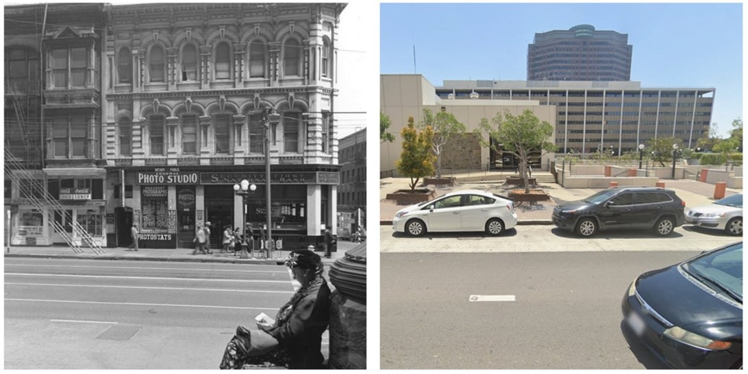
The same corner, seventy-two years apart: the Ducommun Block in 1950 and the walkway that replaced it in 2022, where Commercial Street itself no longer exists. |
 |
|
| (1950 vs 2022)* - Looking east toward the Ducommun Building on the northeast corner of Main and Commercial streets in 1950, and the same vantage point in 2022, where the Los Angeles Mall and a pedestrian walkway now occupy the site. Commercial Street itself was vacated and absorbed into the surrounding complex. Photo comparison by Jack Feldman. |
| Historical Notes
The 1950 panel of this comparison shows the Ducommun Block at what was still recognizably the corner that had anchored Commercial Street since the 1870s — the brick construction, the ground-floor retail, the street still open and in use. The 2022 panel shows what replaced it: the Los Angeles Mall, opened in 1973 as part of the Civic Center redevelopment, and the pedestrian walkway that now crosses the site where Commercial Street once ran. Commercial Street itself was vacated and absorbed into the surrounding complex, leaving no physical trace of the corridor that had been the commercial heart of the city for decades after Los Angeles's founding. The comparison captures in a single frame the full arc of Commercial Street's history — from the mercantile ambitions of the 1860s through the quiet decline of the mid-twentieth century to the complete erasure of the 1970s. The marble bench visible in the 1950 Hylen photograph is gone. The Ducommun Building is gone. The street is gone. What the 2022 image preserves, perhaps unintentionally, is the sense of ordinary civic space that replaced an extraordinary piece of Los Angeles history — a pedestrian walkway where one of the city's founding addresses used to be. |
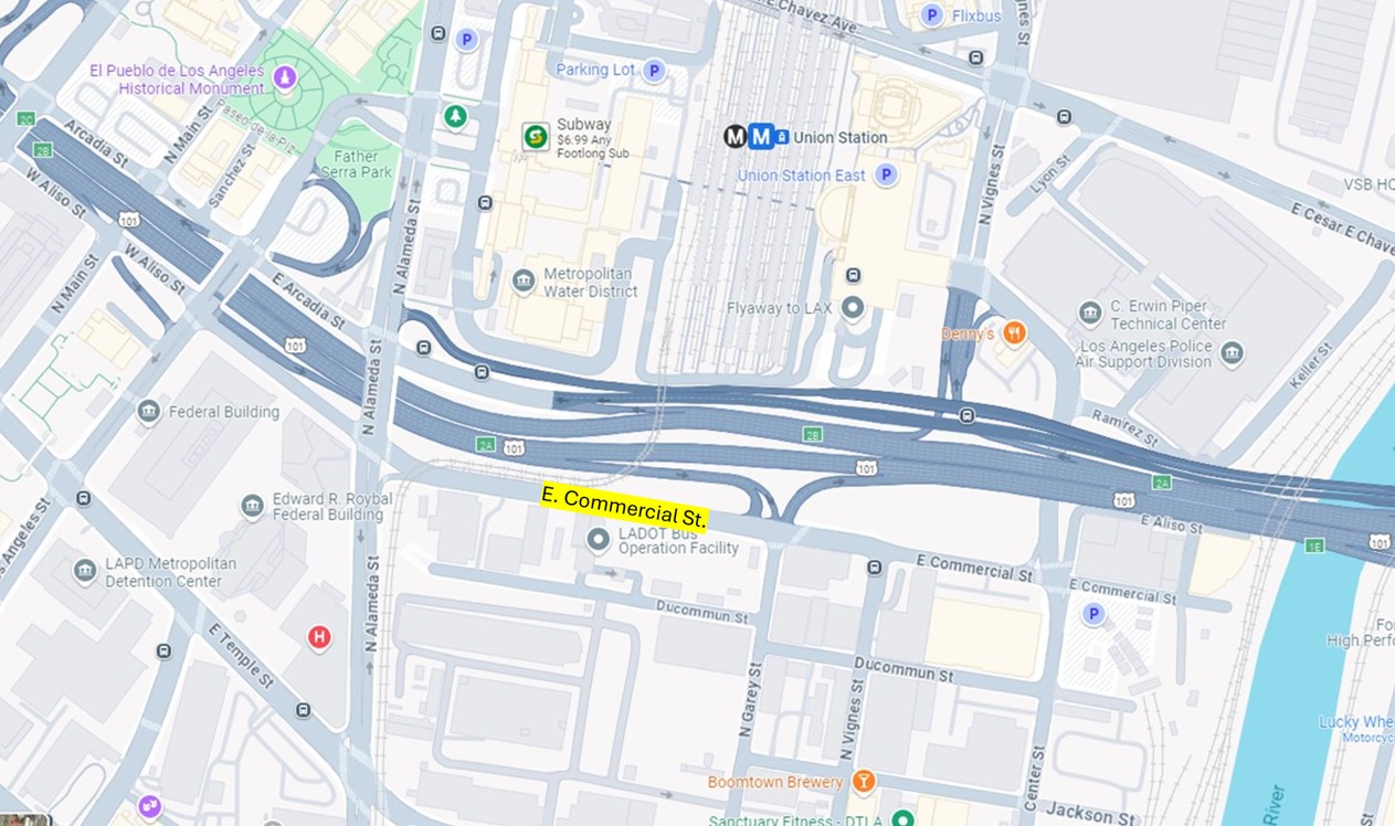
A 2024 Google Map shows what survives: four short blocks of East Commercial Street between Alameda Street and the Los Angeles River, the last physical remnant of a street that once defined the city. |
 |
|
| (2024)* - Google Map showing the remaining four blocks of Commercial Street in downtown Los Angeles, running east from Alameda Street to the Los Angeles River. |
| Historical Notes
The four blocks of East Commercial Street that survive today between Alameda Street and the Los Angeles River bear almost no resemblance to the original district. The street now runs alongside the 101 Freeway, separated from it by a sound wall, passing between parking structures and light commercial buildings that serve the surrounding Little Tokyo and Arts District neighborhoods. The Gold Line light rail crosses Alameda Street just to the north, connecting Union Station to Boyle Heights and East Los Angeles along a corridor that was once the eastern edge of the original Commercial Street district. It is a functional but largely anonymous stretch of downtown infrastructure, nothing in its current form suggesting the history embedded in its name. The survival of the street name itself is the most significant remnant. Commercial Street appears on Los Angeles maps as early as the 1860s, predating most of the street names that define the modern downtown grid. That it still appears on maps in 2024 — however disconnected from its origins — means the name has outlasted the buildings, the businesses, the merchants, and very nearly the memory of the district it once described. The photographs in this collection exist precisely because a small number of people recognized, before it was too late, that what was disappearing on Commercial Street was not just real estate but the physical foundation of the city of Los Angeles. |
Research, writing, and image curation by Jack Feldman, Water and Power Associates, with editorial assistance.
* * * * * |
|
Other Sections of Interest |
|
Water and Power in Early LA |
|
Newest Additions |
New Search Index |

A new SEARCH INDEX has been added to help navigate through the thousands of topics and images found in our collection. Try it out for a test run.
Click HERE for Search Index |
* * * * * |
< Back