Early Views of Poundcake Hill
 |
|
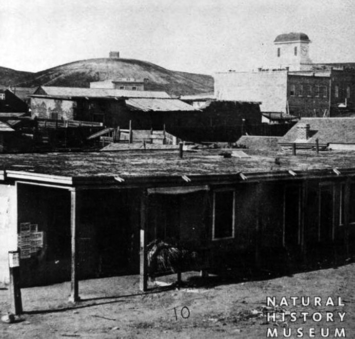
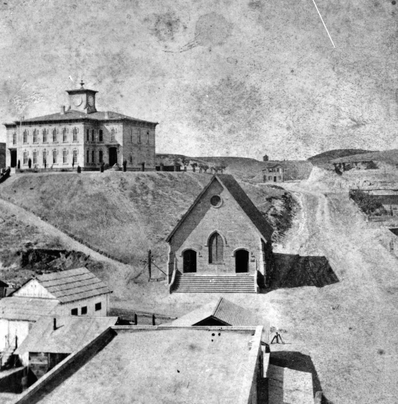
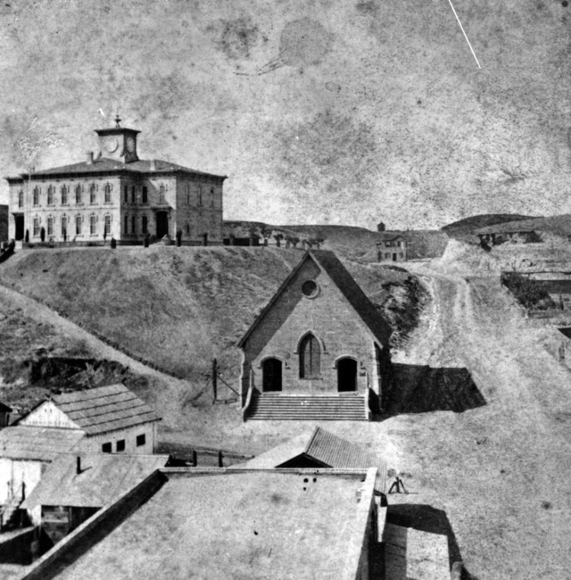
| (ca. 1860)* – View looking northwest from Los Angeles Street showing Telegraph Hill (later Poundcake Hill) with small structure at its top. The Clocktower Market and Courthouse (built in 1858) can be seen at upper-right (Spring and Court streets). Photo by William Godfrey, courtesy of Seaver Center for Western History Research, Los Angeles County of Museum of Natural History. |
Historical Notes Poundcake Hill was first known to English-speaking Angelenos as Telegraph Hill for the semaphore tower that once stood on its summit, it eventually gained a new name, derived from its resemblance to the round, plump dessert food. When the Southland's first high school rose from its top in 1873, the hill stood high above Temple Street below. Later, construction of an imposing, red-sandstone county courthouse (1891) on the site shortened the hill's stature, and after the courthouse's 1936 demolition, development of the Los Angeles Civic Center and construction of the new Clara Shortridge Foltz Criminal Justice Center flattened Poundcake Hill beyond recognition. |
 |
|
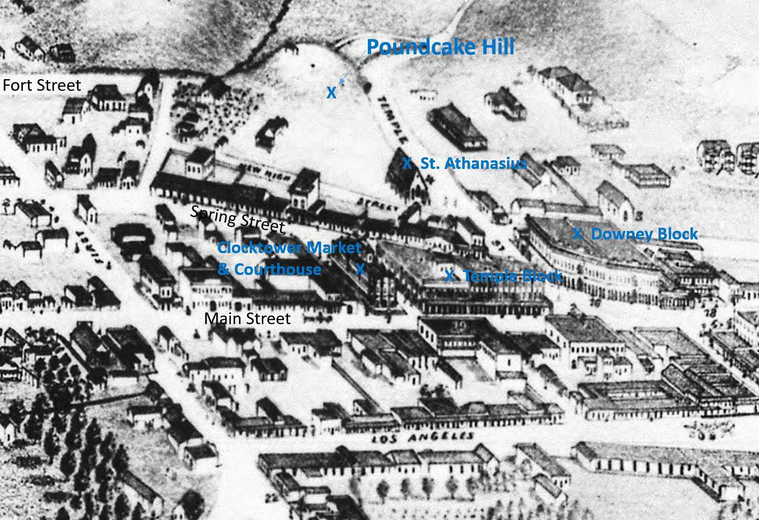
| (1871)* - Photograph of a lithograph showing Los Angeles as it appeared in 1871 with Poundcake Hill at top. Also seen and highlighted are: St. Athanasius, Downey Block, Temple Block and the Clocktower Market/Courthouse. |
Historical Notes In 1873, Los Angeles High School (1st high school in the Southland) would be built on top of Poundcake Hill. The name of the school has led to some confusion due to its evolving role in early Los Angeles education. Initially, it was established as Central School, serving as an elementary school. As the city's educational needs grew, four rooms within the building were allocated for secondary education, which led to the formation of Los Angeles High School, the first public high school in the city. Despite this distinction, the school building continued to be referred to by both names—Central School for its original function and Los Angeles High School for its role in secondary education. This dual usage contributed to historical inconsistencies in naming references. Fort Street (upper left) would be extended horizontally to cross Temple Street. It would also be renamed “Broadway” in 1890. |
.jpg) |
|
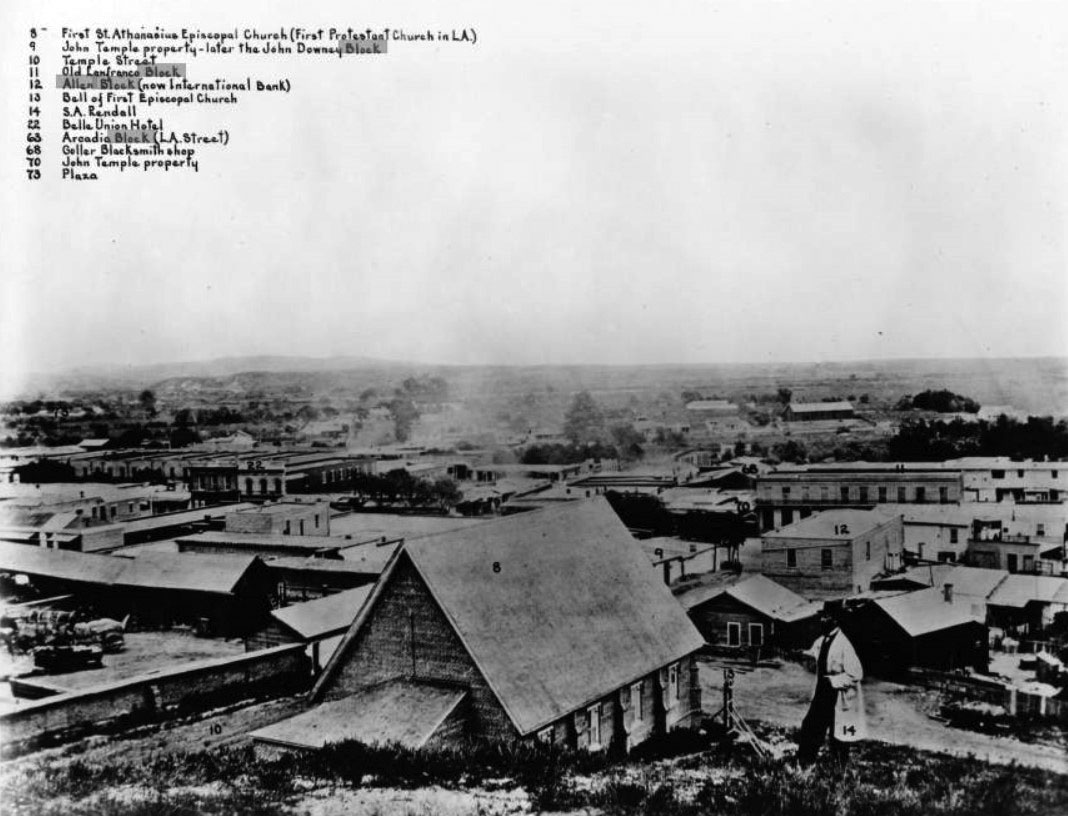
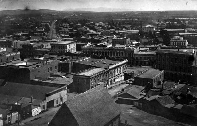
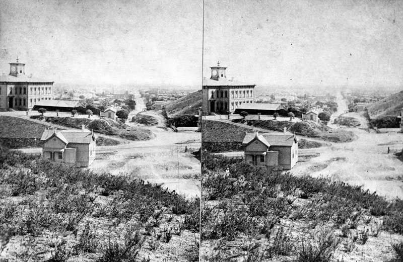
| (ca. 1869)* - Right panel of a panoramic photograph of downtown Los Angeles looking southeast from "Poundcake Hill" with each property annotated and listed at top. The Clocktower Market and Courthouse (No. 20) is seen at left. |
Historical Notes The above photo was taken from a section of Bunker Hill called "Poundcake Hill", the future site of the old Los Angeles High School (built in 1873) and later the location of Los Angeles County Courthouse (built in 1891). The Hall of Records was also built there adjacent to the courthouse (1908). |
.jpg) |
|
| (ca. 1869)* - Panoramic photograph of downtown Los Angeles looking southeast from "Poundcake Hill" with each property annotated and listed at top. The photographer, S. A. Rendall, can be seen standing in his own photo (No. 14). |
Historical Notes It was this time that Los Angeles began growing faster than anywhere in the country. By 1870, the City's population increased to 5,730, a 350% jump from when it was incorporated as a municipality in 1850. By 1900, LA's population would mushroom to over 100,000 people. |
 |
|
| (ca. 1869)* – Closer view showing photographer S. A. Rendall standing on the hillside of "Poundcake Hill" with the St. Athanasius Episcopal Church (First Protestant Church in LA) directly below him at center (No. 8). |
Historical Notes S. A. Rendall, the photographer of the amazing panoramic photo seen above, is mentioned in a 1911 publication titled: OUTPOST – Preserving Historical Data by W. S. Broke. “Remembering that no city in the United States has had a rate of growth commensurate with that of Los Angeles, the preservation of historical data becomes of pressing importance. Much of the photographic material illustrating the early life of the city has been preserved but as far as can be ascertained little of this immediately available for all comers. … There does not appear to have been any systematic attempt to preserve photographs of the city prior to the early 80s. The late S. A. Rendall, whose children now reside in Los Angeles, was a photographer who did much toward preserving the appearance of the early Los Angeles—the city of the ‘60s and ‘70s. What has become of most of his negatives is not known, although they would be of immense historical value were they now available. Perhaps the best thing that he left behind is a bird’s eye view of Los Angeles taken in 1868 from the site of the present courthouse. This photograph is the property of George W. Hazard, who has it covered by copyright, and who has it on sale. It is a remarkable photograph in every way.” |
 |
|
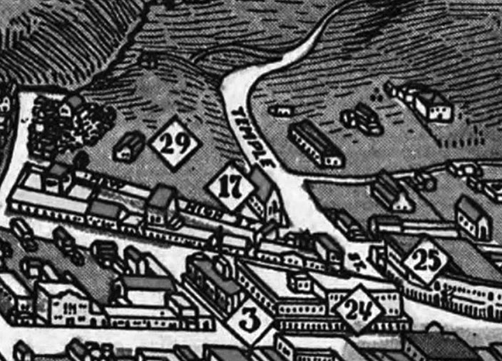
| (1871)* - Detail from another early map of Los Angeles. Number 17 is St. Athanasius; “29” is the future site of the Los Angeles High School; “3” is the old Clocktower Market/Courthouse, site of today’s City Hall; “24” is the Temple Block; and “25” is the Downey Block, where Spring and Main Streets come together. |
 |
|
| (1870s)* - View looking northeast from the top of Poundcake Hill showing the Downey Block (center) at Temple and Main streets. The building with the pitched roof in the foreground is St. Athanasius Episcopal Church. Across the street is the Temple Street Stables (lower-left). Also seen is the Temple Block at center-right. The Los Angeles River runs horizontally across the top of the photo. The wide street at upper left is Aliso Street where the 101 Freeway runs today. |
Historical Notes Aliso Street (wide diagonal street seen above) was first named in 1854. When early settlers arrived at the Los Angeles River (El Rio de Nuestra Senora de Los Angeles de Porcinucula) by way of Mission Road, they picked as a nearby gathering point a huge sycamore that gave them shelter and became a landmark, "El Aliso." That Spanish word for sycamore was later used to name the road carved out near the river. |
 |
|
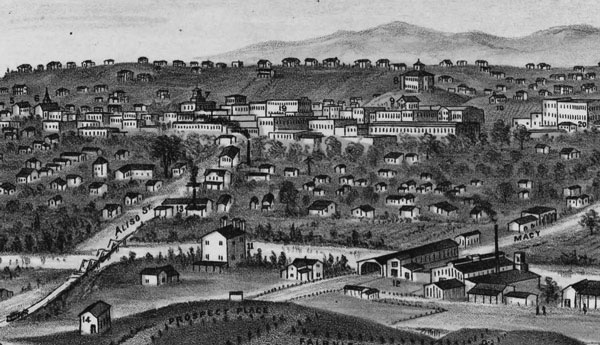
| (ca. 1873)* - Detail of a drawing showing Los Angeles High School (built in 1873) sitting high on top of Poundcake Hill (top center-right) with St. Athanasius Episcopal Church seen just below it. The view looks west toward downtown Los Angeles from Boyle Heights with the Los Angeles River running horizontally near bottom of sketch. Drawing by E.S. Glover of Los Angeles. |
Historical Notes Also seen above is Los Angeles' first permanent bridge, the Macy Street Bridge (lower-right). It was a covered bridge reminiscent of those in New England (built in 1870). Click HERE to see more. |
 |
|
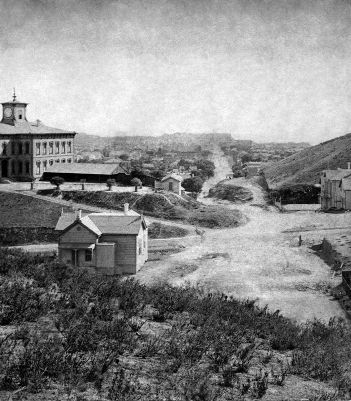
| (1873)* - View showing Los Angeles High School on Poundcake Hill, high above downtown LA. The view is looking northeast from the hill on North Broadway at Court Street. Temple Block and the Clocktower Market/Courthouse can be seen to the right of the school and at bottom of the hill. This would be the location of today's City Hall. Broadway, first known as Fort Street, was cut through the bushes in the foreground. |
Historical Notes Construction on Los Angeles' first high school, which was also the first and only one in Southern California for a number of years, began on July 19, 1872, at the former site of Central School on what was then known as Poundcake Hill. It was located at the southeast corner of Fort Street (later Broadway), which the front of the school faced, and Temple Street, with the back of the school to New High Street (later Spring Street). As it was on the hill, a few hundred feet from the streets below, steep wooden stairways led up to the schoolyard. The name of the school has led to some confusion due to its evolving role in early Los Angeles education. Initially, it was established as Central School, serving as an elementary school. As the city's educational needs grew, four rooms within the building were allocated for secondary education, which led to the formation of Los Angeles High School, the first public high school in the city. Despite this distinction, the school building continued to be referred to by both names—Central School for its original function and Los Angeles High School for its role in secondary education. This dual usage contributed to historical inconsistencies in naming references. The first graduating class, in 1875, consisted of seven students. |
 |
|
| (ca. 1875)* - View showing the first Los Angeles High School located on Poundcake Hill. A horse can be seen standing by a fence in the left foreground. |
Historical Notes The schoolhouse was completed at a cost of $20,000, in 1873. Nearby, in succession, was the Court House, the City Hall, the Jones-Lindley Market and the Post Office. The first principal was Rev. Dr. William T. Lucky (1821–1876) and the first graduating class, in 1875, consisted of seven students. |
 |
|
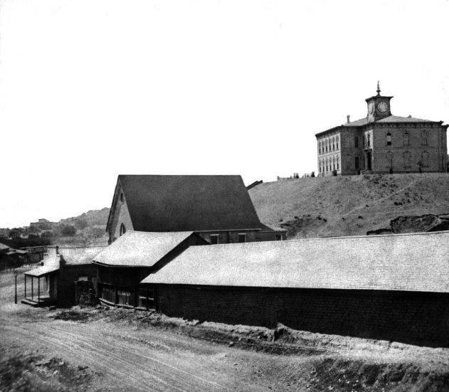
| (ca. 1873)* - View showing the newly built Los Angeles High School, the Griffith, Lynch and Company lumber yard and St. Athanasius Episcopal Church. New High Street is in the foreground and the intersection with Temple Street is at the left center edge. |
Historical Notes This photograph was taken by pioneer Los Angeles photographer Henry T. Payne about 1873 and shows the newly built high school on Poundcake Hill. |
 |
|
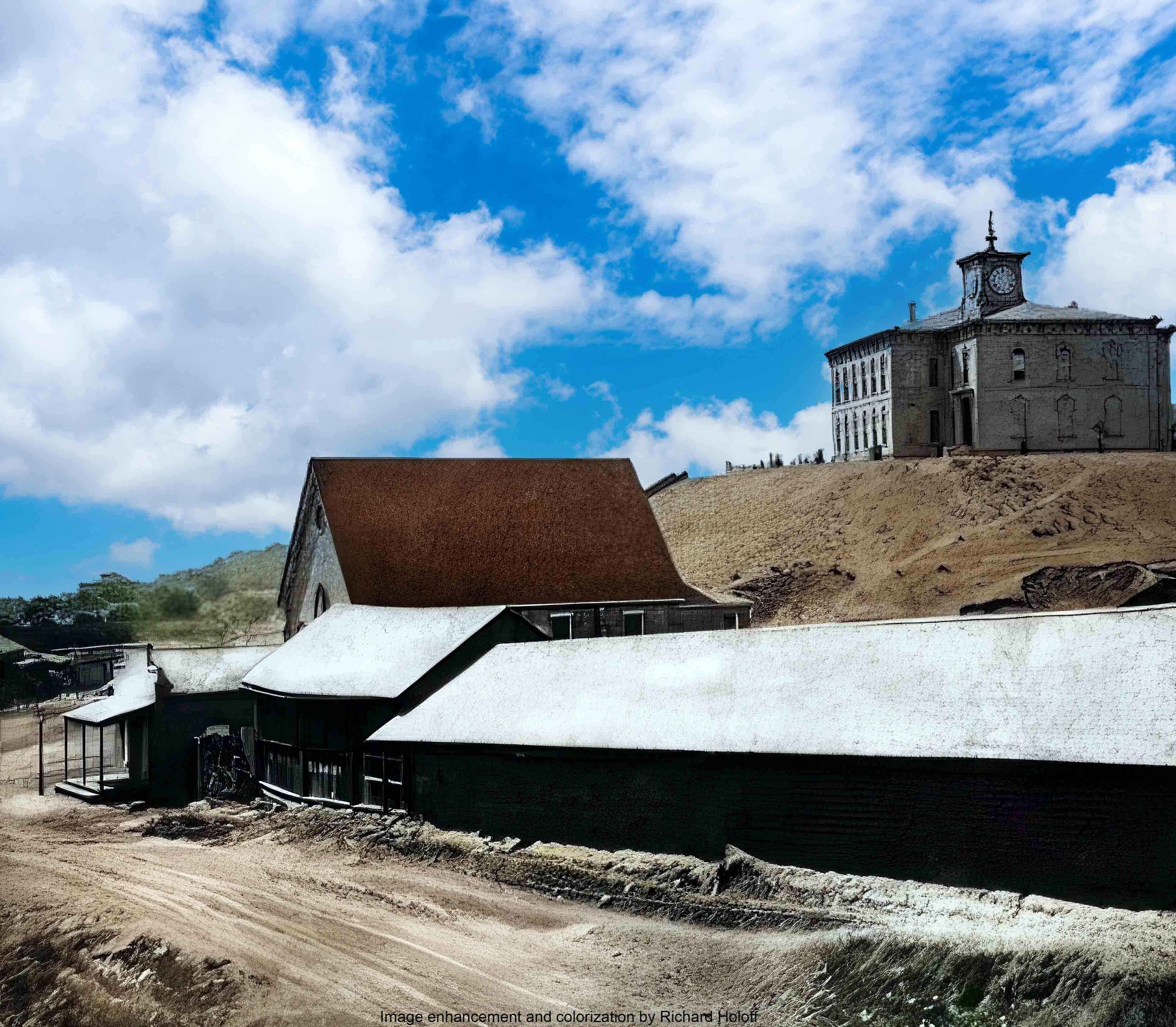
| (ca. 1873)* - View showing the newly built Los Angeles High School, the Griffith, Lynch and Company lumber yard and St. Athanasius Episcopal Church. New High Street is in the foreground and the intersection with Temple Street is at the left center edge. Image enhancement and colorization by Richard Holoff. |
 |
|
| (ca. 1874)* - View showing Los Angeles High School atop Poundcake Hill and St. Athanasius Episcopal Church (center), widely thought to be the first Protestant house of worship in Los Angeles. The street to the right running away from the camera is Temple Street, named after John Temple*. The street in front of St. Athansius is New High Street (later Spring Street). |
Historical Notes Built in 1864, St. Athanasius was the first Episcopal church in the City of Los Angeles. It was situated on the northeast corner of Poundcake Hill at Temple and New High Streets (later Spring Street). *In 1859, Temple Street was named after John Temple, who opened the first store in Los Angeles. He built a block of shops, lawyers' offices and a saloon at the junction of Main, Temple, and Spring Streets, where Los Angeles City Hall stands today. |
 |
|
| (ca. 1875)^ - Stereoscopic view of Fort Street (later Broadway) looking south from Fort Moore Hill, at Temple Street. Los Angeles High School sits on Poundcake Hill on the left. |
 |
|
| (1875)*- Looking south on Fort Street (now Broadway) showing Los Angeles High School as seen from Fort Moore Hill. Source: Henry T. Payne stereographic photograph. |
Then and Now
 |
|
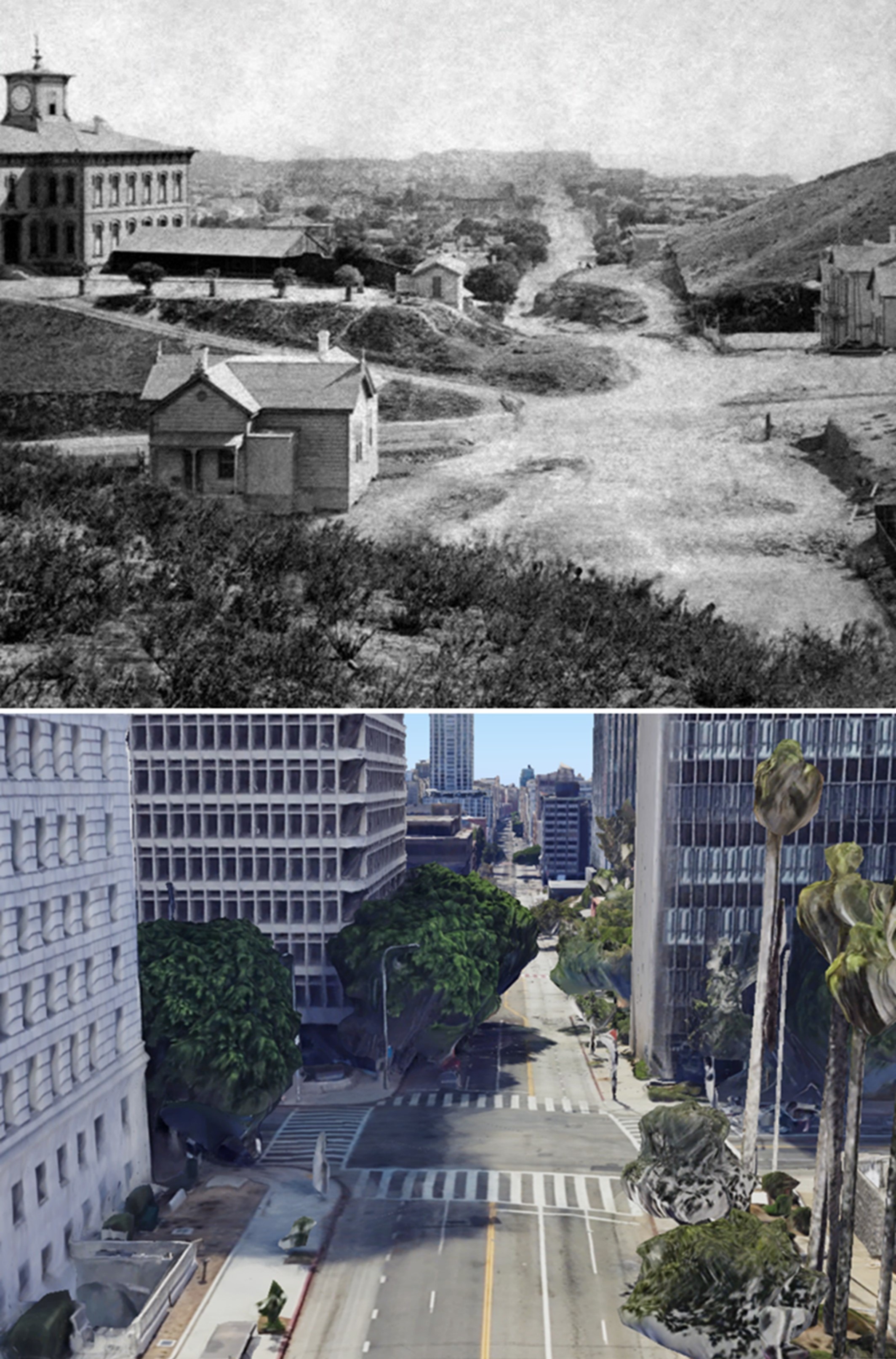
| (1875 vs 2023)* – Looking south on Broadway (originally Fort Streeet) at Temple Street. Los Angeles’ first public High School (LA High School) once stood near the SE corner as seen above (upper-left corner). In 1886 the high school was moved to a new location to make room for the construction of the LA County Courthouse. The courthouse would be torn down in 1936 and replaced by single story courthouse bungalow buildings. In 1972 the Criminal Courts Building later renamed the Clara Shortridge Foltz Criminal Justice Center would be constructed on the site (seen here on the SE corner). Photo comparison by Jack Feldman. |
Historical Notes The original view was taken from Fort Moore Hill, which was later leveled. The current view is a Google Earth perspective from approximately where the top of Fort Moore Hill once stood. |
 |
|
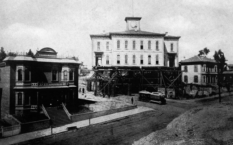
| (1886)* - View showing the Los Angeles High School building being moved over to Temple Street as a couple of people look on. A man standing at the corner of Temple and Forth Street (later Broadway) watches a double trolley traveling by, and two people can be seen exiting the Clifton House on the left. |
Historical Notes In 1886, the decision was made to move the high school building to Sand Street (later California Street, now part of the Hollywood Freeway), just to the west of North Hill Street and below the south side of Fort Moore Hill, in order for the Los Angeles County Courthouse to be built on Poundcake Hill. The contractor, Mr. Hickam, said he could do the job with scaffolding, rollers, horses and workmen. But his bid turned out to be too low. He lost a considerable amount of money because of his elaborate preparations, including the high wooden trestle which carried the building over the intersection of Temple and Fort Street (later Broadway). During the process of moving, the contractor managed to get the schoolhouse halfway up Temple Street when he ran out of money and left it right in the middle of the street. It was there for a good while. They jacked it up on scaffolding high enough for the Temple Street street cars to run under it. |
 |
|
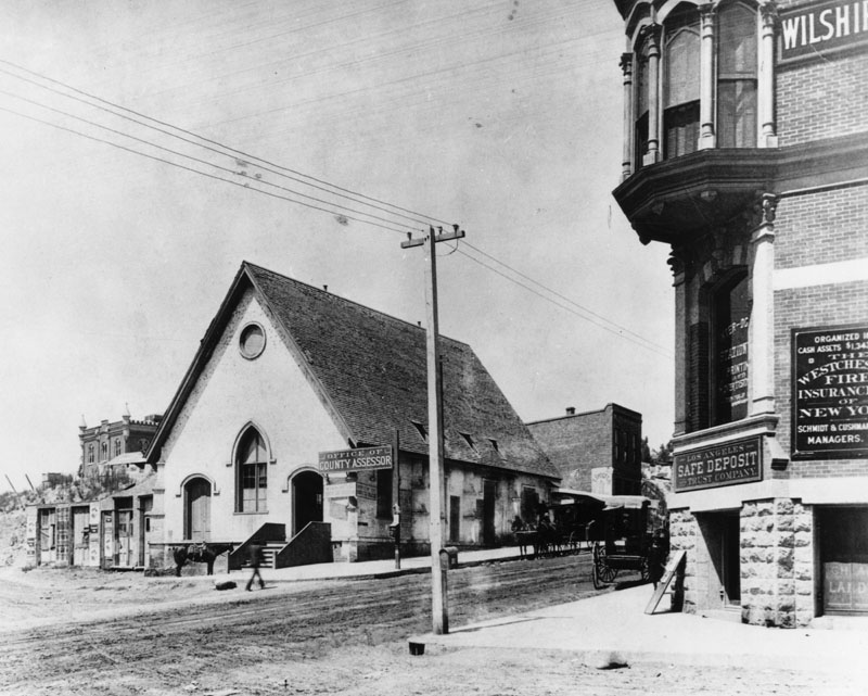
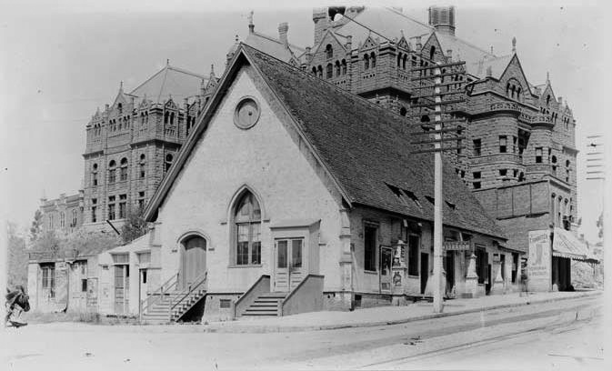
| (ca. 1886)* - View looking at the SW corner of Temple Street and New High Street (later Spring Street) shortly after the Los Angeles High School building was moved off of Poundcake Hill. The old St. Athansius Episcopal Church (renamed St. Paul's in 1881) is now a Los Angeles County Assessor's office. |
Historical Notes In 1883, the church building was sold to Los Angeles County, and a new St. Paul's Church was built where the Biltmore Hotel now stands at Pershing Square. |
 |
|
| (1891)* - View of the original St. Athanasius Episcopal Church building shortly before its demise, with a the new County Courthouse in the background, still under construction. |
Historical Notes The original 1860s-era bell from St. Athanasius today lives on at the Church of the Epiphany at 2808 Altura Street in Lincoln Heights. |
 |
|
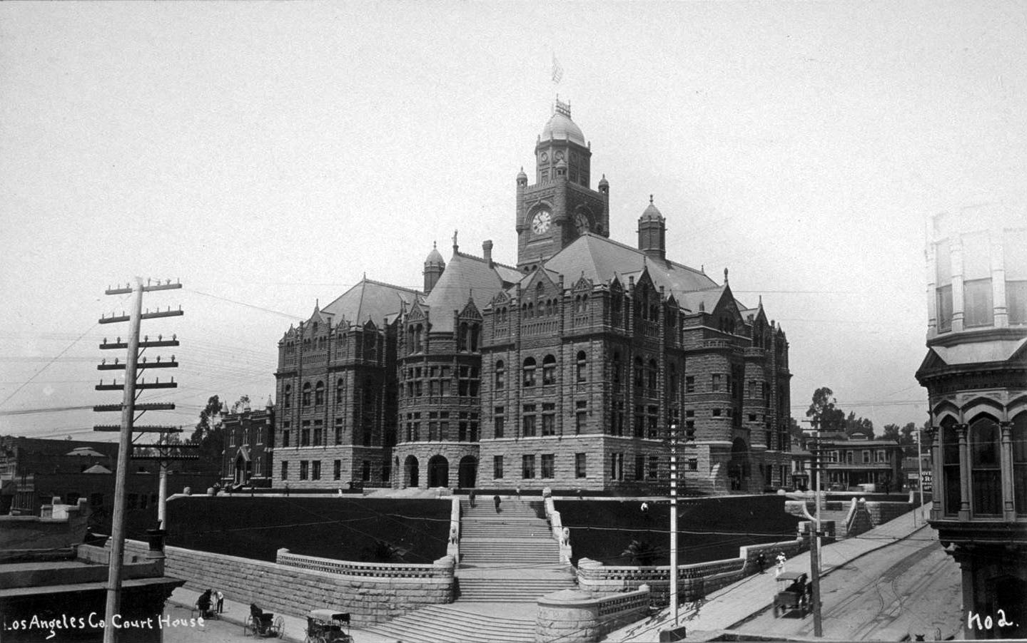
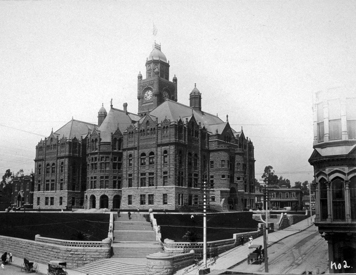
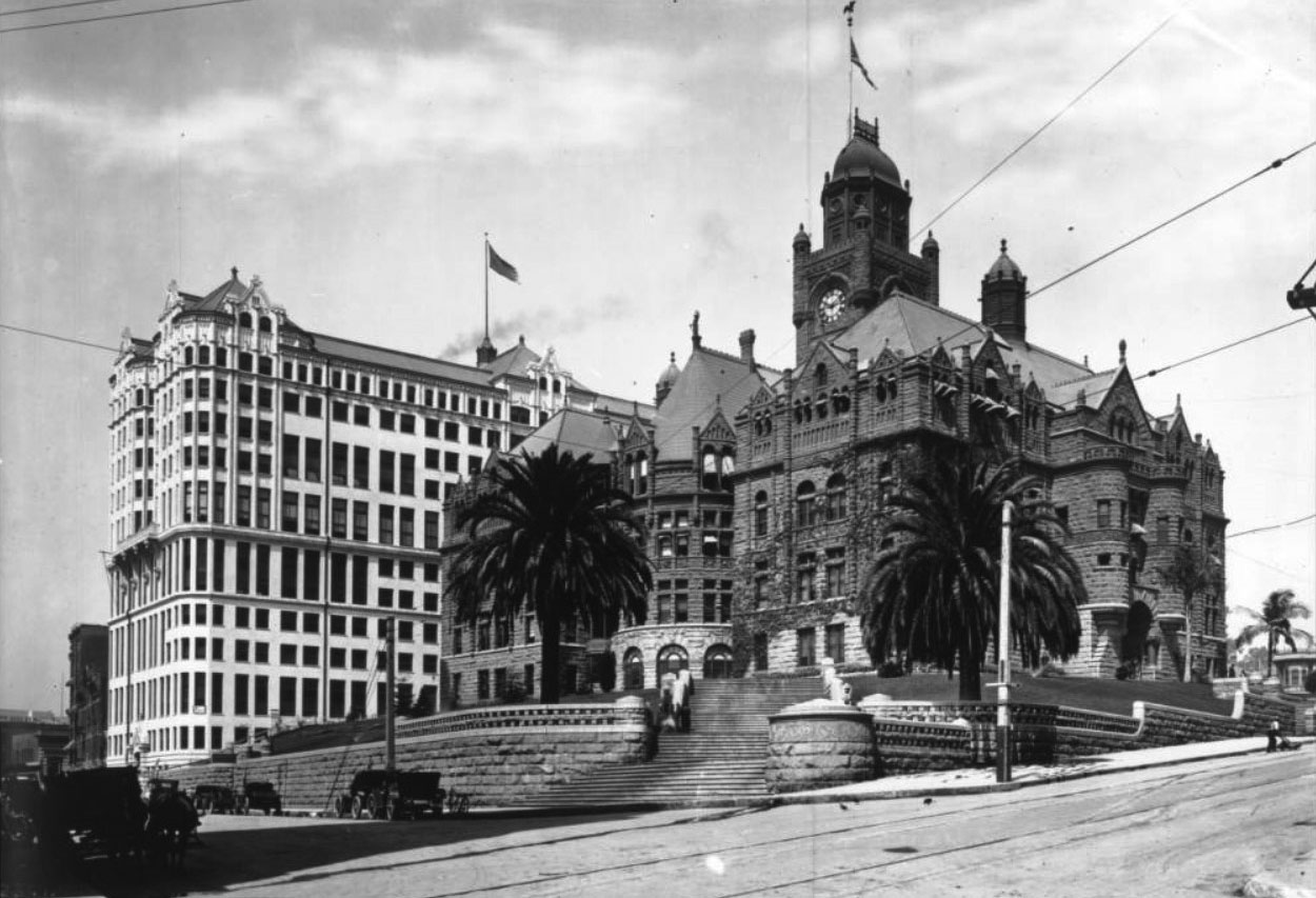
| (ca. 1890s)* - View showing the new Los Angeles County Courthouse (completed in 1891) at the intersection of New High and Temple streets with the old St. Athanasius Episcopal Church building now gone. The courthouse is also referred to as the Red Sandstone Courthouse. |
Historical Notes Through more than 150 years the county has used at least eight buildings as its county courthouse. All have been situated within a mile of each other in downtown Los Angeles south of the original plaza in what has for the past 80 years been called the Civic Center. ◆ The first county courthouse was in the adobe Bella Union Hotel, where court was held in rented rooms from 1850 to 1852. |
Before and After
|
|
 |
|
| (1886 vs 1891)* - View looking at the SW corner of Temple and New High streets before and after construction of the Los Angeles County Courthouse. |
 |
|
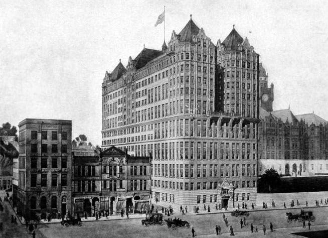
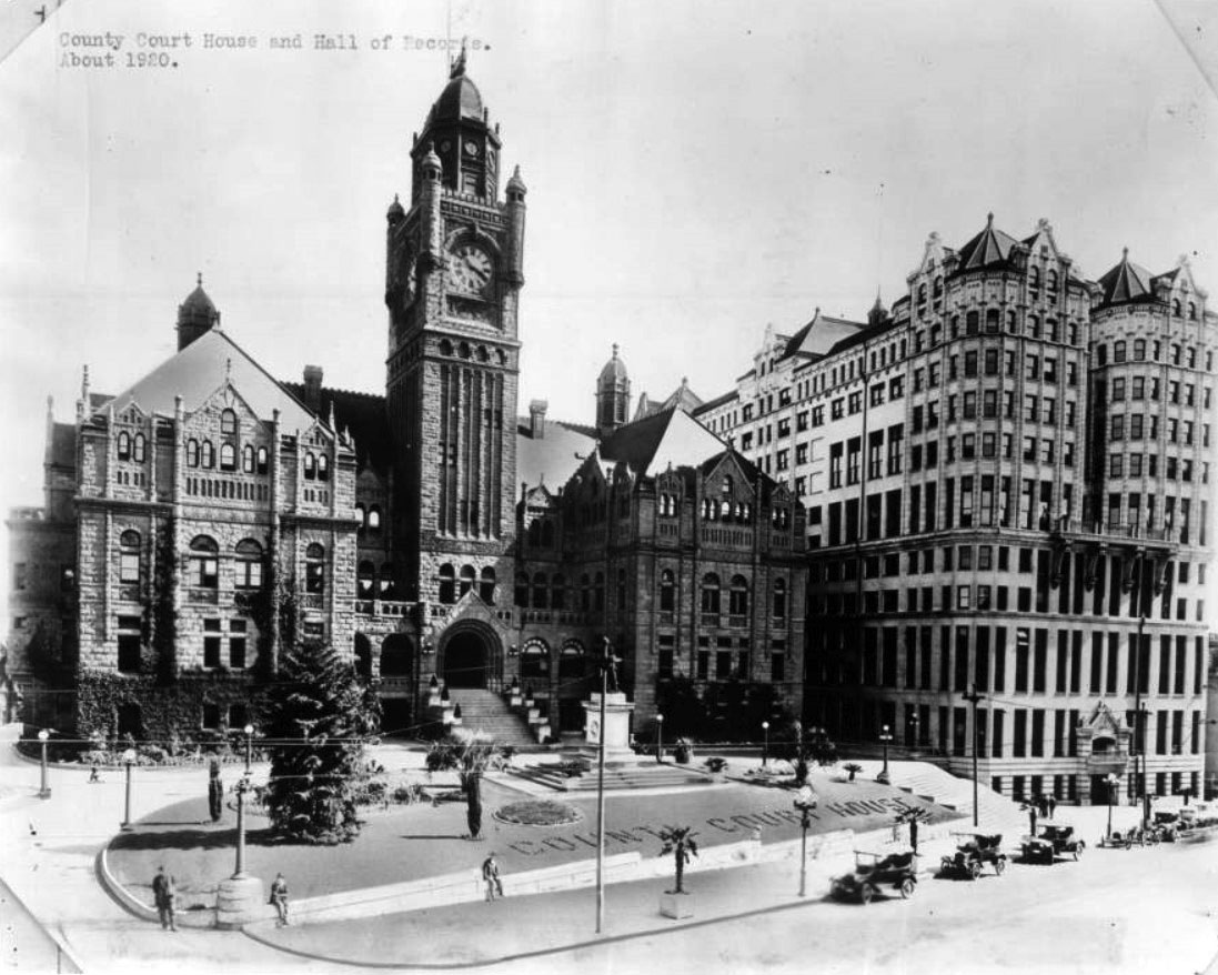
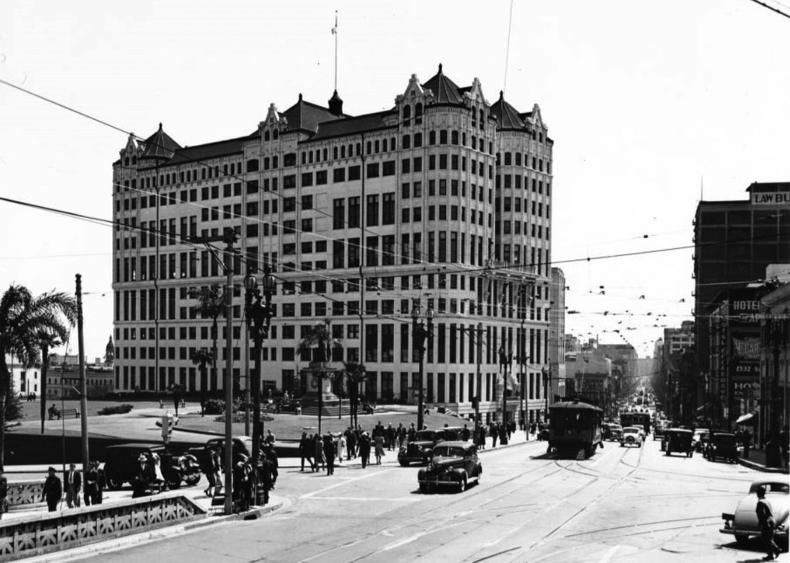
| (1910)* - Postcard view showing the newly constructed Hall of Records Building located just south of the LA County Courthouse. As with the County Courthouse, the Hall of Records extended from New High Street (seen above) all the way to Broadway on its backside. |
Historical Notes Built between 1909 and 1912 to relieve overcrowding next door in the county’s red-sandstone courthouse, the Hall of Records consolidated most county offices under one lavishly ornamented roof—a showy headpiece that featured finials, pyramidal gables, and copper ribbing. Architects Frank Hudson and William Munsell divided its upper floors into two pairs of wings, which joined at a central elevator shaft, and clad the walls in brick and terra cotta above a granite base. |
Before and After
|
|
 |
|
| (1891) vs. 1917)* - View looking at the SW corner of Temple and New High streets before and after construction of the Hall of Records. |
 |
|
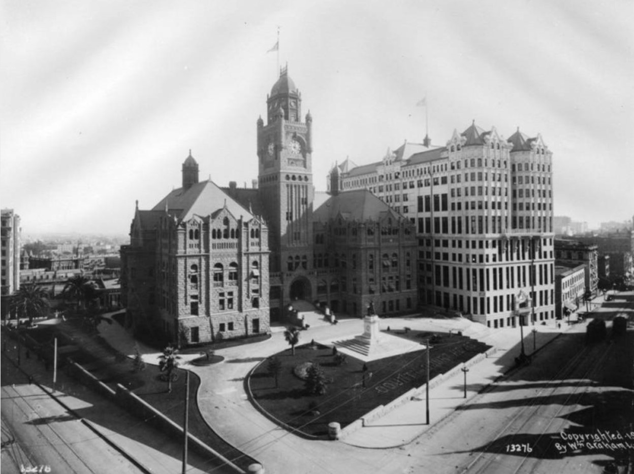
| (ca. 1920)* - View looking at the southeast corner of Broadway and Temple Street showing both the County Courthouse and Hall of Records on what was once Poundcake Hill. |
Historical Notes Built between 1909 and 1912 to relieve overcrowding next door in the county’s red-sandstone courthouse, the Hall of Records consolidated most county offices under one lavishly ornamented roof—a showy headpiece that featured finials, pyramidal gables, and copper ribbing. Architects Frank Hudson and William Munsell divided its upper floors into two pairs of wings, which joined at a central elevator shaft, and clad the walls in brick and terra cotta above a granite base. |
Before and After Construction of Today's City Hall
 |
|
 |
|
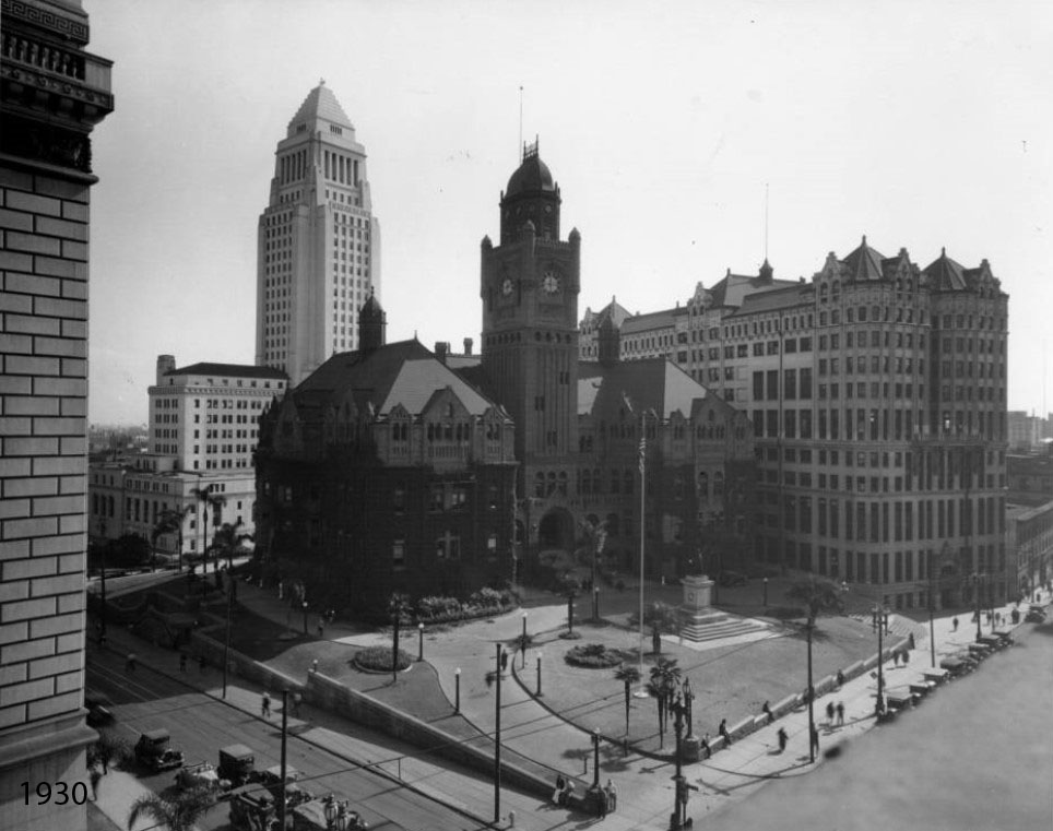
| (1911 vs. 1930)* - View looking toward the southeast corner of Temple and Broadway (Poundcake Hill) before and after City Hall was built (1928). The building at left is the Hall of Justice (built in 1927). |
Historical Notes The old LA County Courthouse would be demolished in 1936. The Hall of Records stood until 1973. |
 |
|
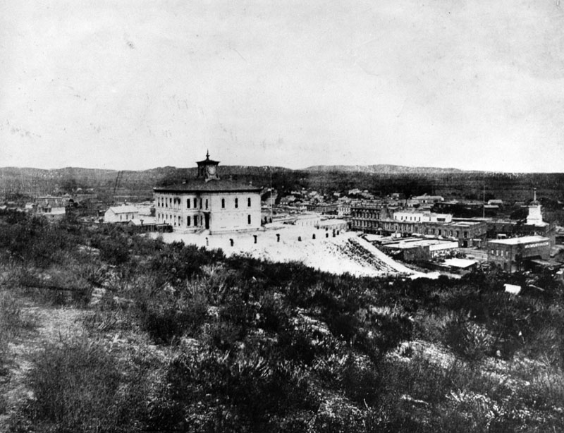
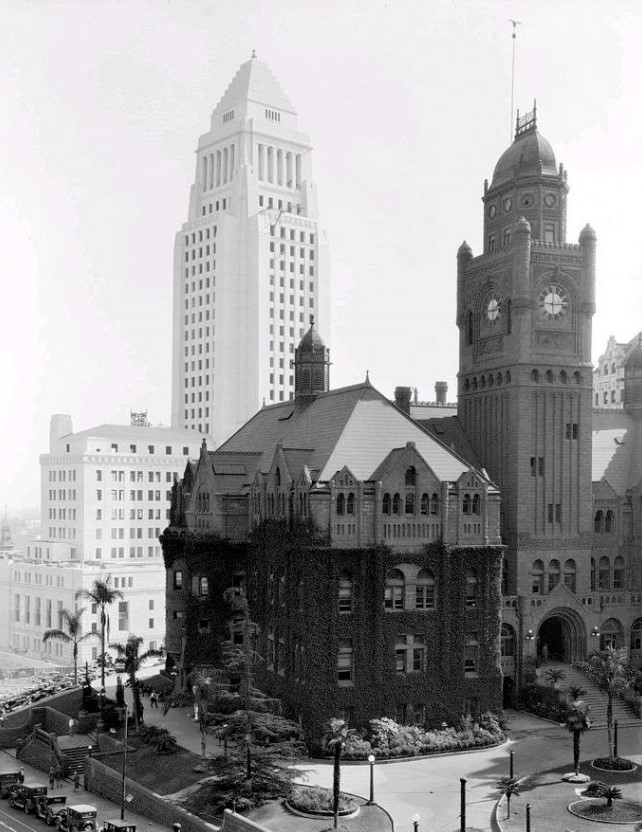
| (1928)* - A great shot of Poundcake Hill where we see the ivy-covered County Courthouse in the foreground and the newly constructed City Hall across Spring Street in the background. The Hall of Records is out of view on the right. View is looking southeast. |
Historical Notes City Hall was constructed between 1927 and 1928. It replaced the old City Hall Building which stood at 226 S. Broadway since 1888. Click HERE to see more on the construction of today's Los Angeles City Hall located at 200 N. Spring Street. |
 |
|
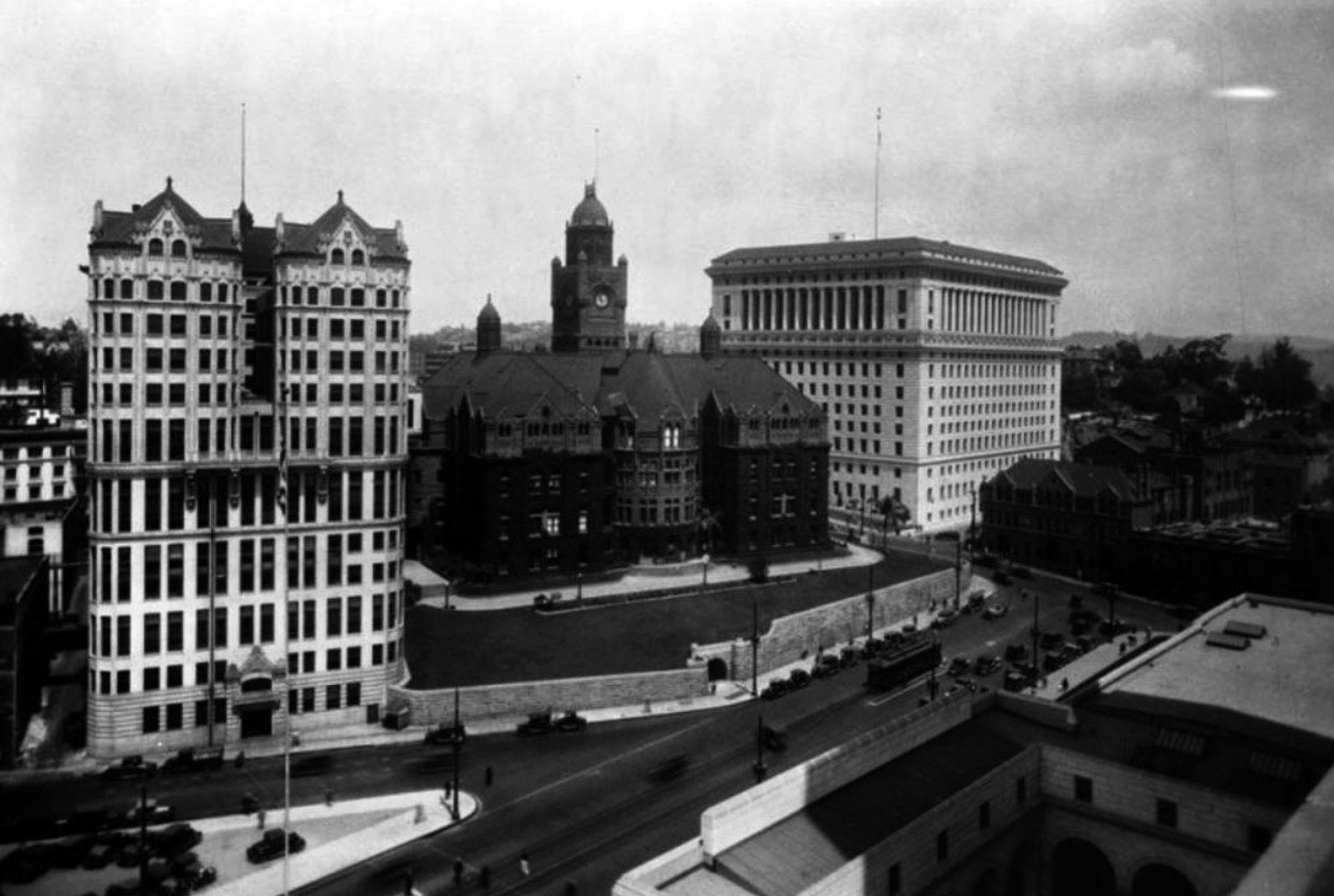
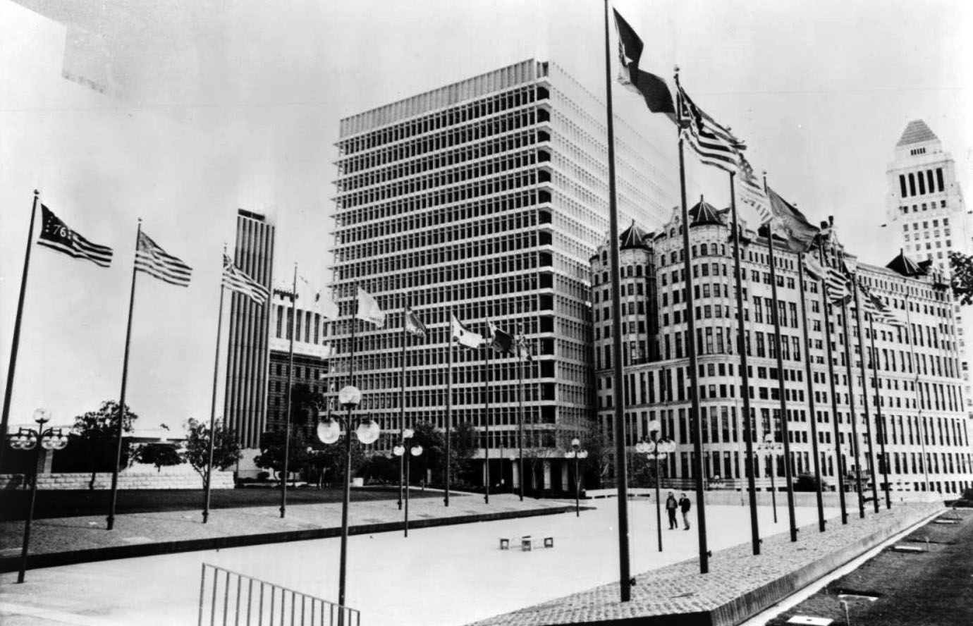
| (ca. 1929)* - View looking northwest from City Hall toward the Hall of Records (left), County Courthouse (once the site of LA High School) and Hall of Justice (NE Corner of Temple and Broadway). A realigned Spring Street is seen in the foreground running toward Temple Street at right. New High Street runs diagonally in front of the Hall of Justice and merges with Spring Street at center-right. |
Historical Notes Spring Street was reconfiguered to parallel Main Street when the current City Hall was constructed (1927-1928). Before then Spring merged with Main Street at Temple Street. Click HERE to see more in Early Views of the Junction of Main, Temple, and Spring Streets. |
 |
|
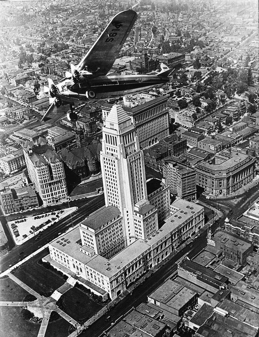
| (ca. 1929)* - Aerial view looking northwest showing an airplane (Fokker F.10) buzzing over City Hall, with the Hall of Records and County Courthouse seen across a newly aligned Spring Street (center-left. |
 |
|
| (ca. 1930s)* – Aerial view looking down at the Civic Center, annotated with street names and original location of Poundcake Hill. |
 |
|
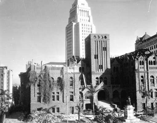
| (1936)* - Demolition of the L.A. County Courthouse at Broadway and Temple with the new City Hall standing in the background. The Hall of Records, built in 1911, appears on the right. The statue in front of the building was that of Senator Stephen M. White. It still exists today but at a different location. |
Historical Notes The Red Sandstone Courthouse on Poundcake Hill, completed in 1891, was damaged beyond repair by the Long Beach earthquake of 1933 and demolished in 1936. The statue of Stephen M. White that stood in front of the courthouse was saved. |
 |
|
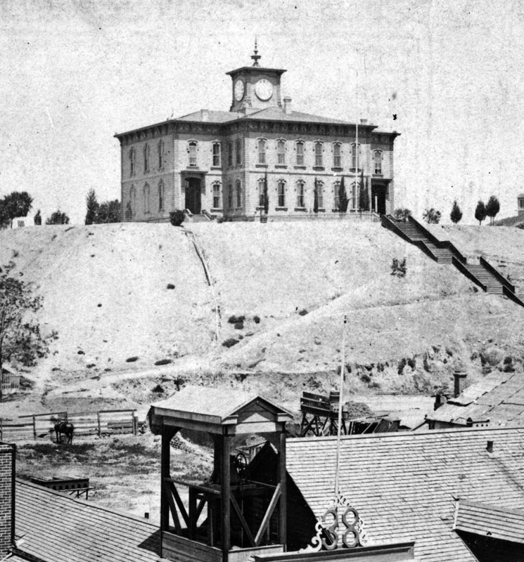
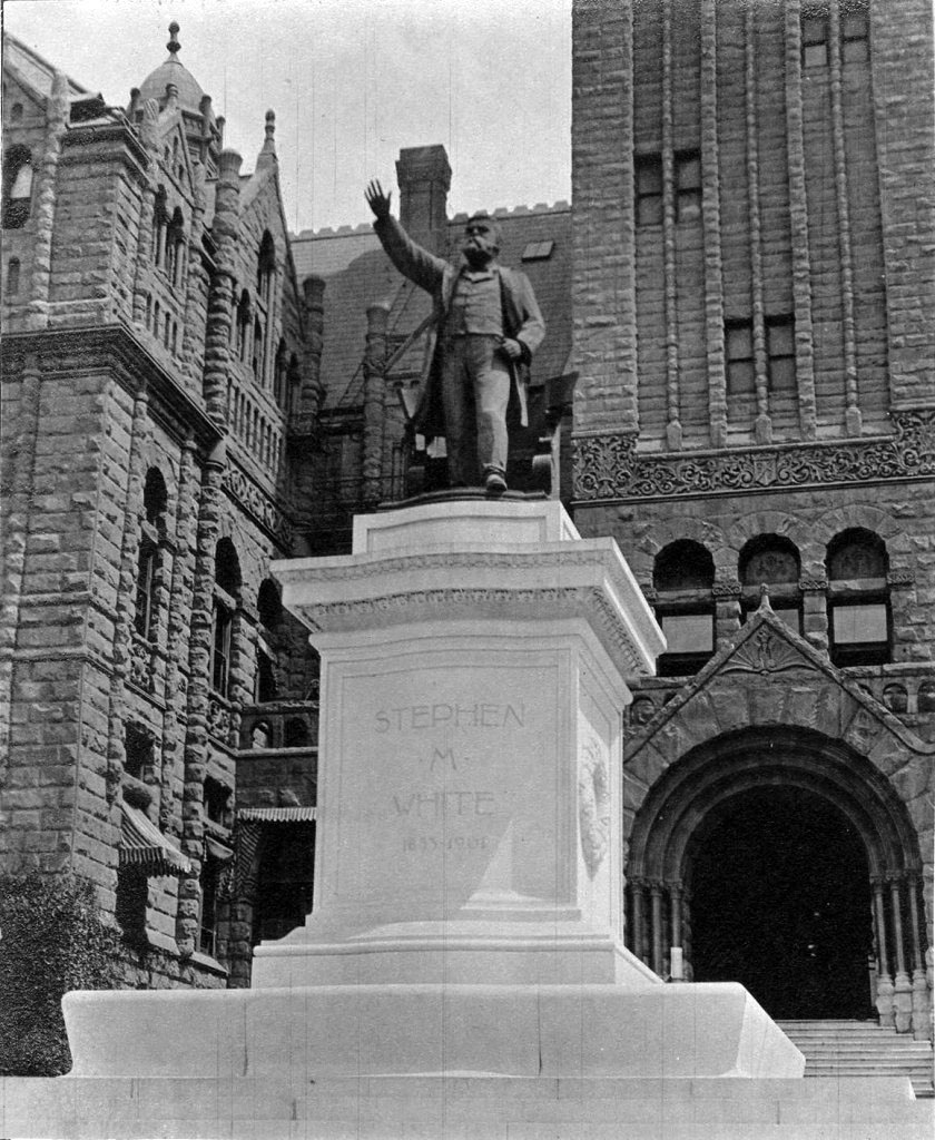
| (ca. 1933)* – View showing the statue of Senator Stephen M. White in front of the entrance to the great Red Sandstone Courthouse. |
Historical Notes Stephen M. White was elected Los Angeles County District Attorney in 1882, State Senator in 1886 and United States Senator in 1893. During his term in the United States Senate, Senator White’s most notable accomplishment was his successful leadership of the fight to create the Los Angeles Harbor in San Pedro as opposed to Santa Monica Bay, the site that was being advocated by powerful railroad interests. The statue of Stephen White was moved several times before finding a home in front of the new County (now Mosk) Courthouse in 1958. It would remain there for 30 years. In 1989, the statue was moved again to its present location, at the entrance to Cabrillo Beach off Stephen M. White Drive, overlooking the breakwater at the L.A. Harbor. Click HERE to see contemporary view. |
 |
|
| (1939)* – View looking south on Broadway at Temple Street showing a park with statue where the Old County Courthouse once stood. Further south is the Hall of Records. |
Historical Notes During World War II bungalows were installed at the park seen above to accomodate military personnel. After the War the bungulows were converted to County offices. |
|
|
| (1948)* – View looking southwest above Temple and Spring Streets showing the Hall of Records and County bungalows where the Red Sandstone Courthouse and original Los Angeles High School once stood. |
 |
|
| (1971)* – View looking west from City Hall across Spring Street toward the Hall of Records and the new Criminal Courts Building which is still under construction at the site of the old County bungalows (seen in previous images). |
Historical Notes The Criminal Courts Building was constructed between 1970 and 1972 on Poundcake Hill where LA High School (1873-1886) and LA County Courthouse (1891-1932) once stood. |
 |
|
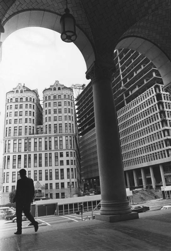
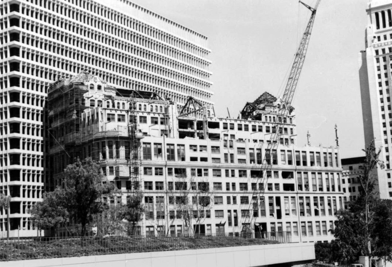
| (1972)^^ – View looking northeast across the Los Angeles County Mall showing the new Criminal Courts Building (later renamed the Clara Shortridge Foltz Criminal Justice Center) where the old Red Sandstone Courthouse once stood followed by County bungalows. To its right is the Gothic-style 1910-built Hall of Records Building with City Hall is in the background. |
Historical Notes In 2002 the Criminal Courts Building was renamed the Clara Shortridge Foltz Criminal Justice Center, after Clara S. Foltz, the first female lawyer on the west coast of the United States (and also the first person to propose the creation of a public defender's office). |
 |
|
| (1972)* – View looking northeast across the Los Angeles County Mall showing the new Criminal Courts Building (later renamed the Clara Shortridge Foltz Criminal Justice Center) where the old Red Sandstone Courthouse once stood. To its right is the Gothic-style 1910-built Hall of Records Building with City Hall in the background. |
Historical Notes The Hall of Records acquired its most distinctive quirk in the late 1920s Spring Street was realigned during the construction of City Hall. The building originally stood flush against New High Street (see previous images). But when the city untangled the maze of streets that once navigated the Civic Center area, it left the Hall of Records standing at an off-angle relative to the new, straightened grid. That odd stance became a liability in the 1960s, as a new Civic Center composed of modern, monumental buildings and arranged around a long, landscaped Civic Center Mall took form. The county considered saving the building by rotating it to align with the new street grid, but the estimated cost of $5 million was considered excessive. Instead, the wrecking ball came. In 1973, the idiosyncratic Hall of Records gave way to a blacktop parking lot—recently converted into the easternmost section of Grand Park. |
 |
|
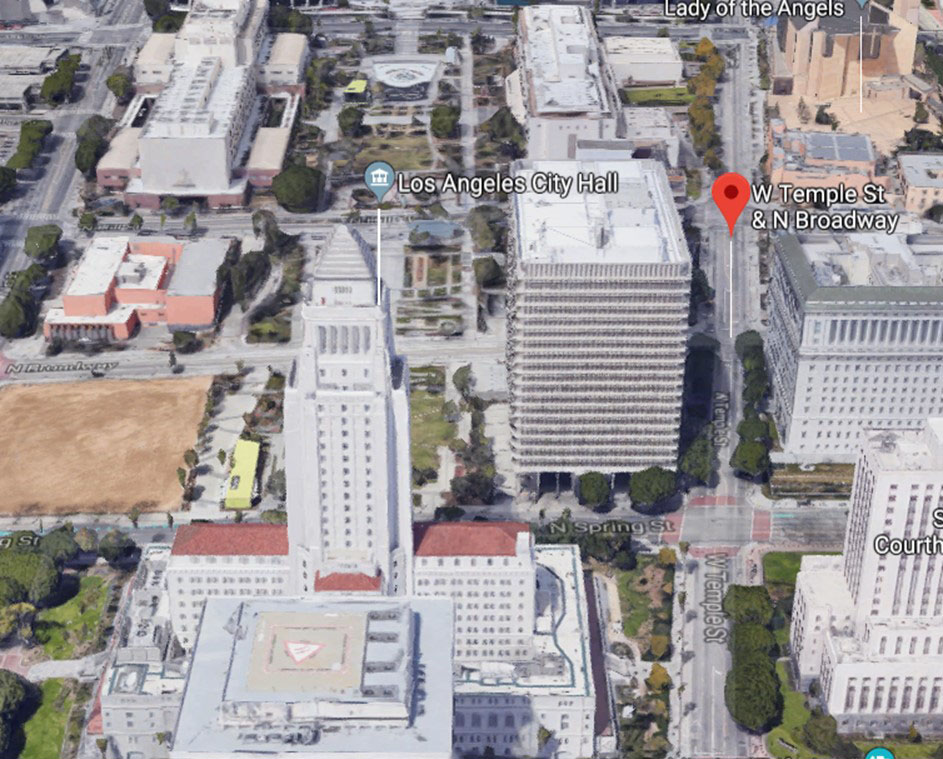
| (2019)* – Aerial view looking down at the 1972-built Clara Shortridge Foltz Criminal Justice Center located on the southwest corner of Spring and Temple streets. It is situated on a hill once called “Poundcake Hill” where several prominent historical buildings once stood: St. Athanasius Episcopal Church – 1st Protestant Church in L.A. (1864-1891); Los Angeles High School – 1st high school in L.A. (1873-1886); Los Angeles County Courthouse (1891-1936); and the Los Angeles County Hall of Records (1910-1972). |
Historical Notes Poundcake Hill once resembled a round, plumb dessert food. When the Southland's first high school rose from its top in 1873, the hill stood high above Temple Street below. Later, construction of an imposing, red-sandstone county courthouse (1891) on the site shortened the hill's stature, and after the courthouse's 1936 demolition, development of the Los Angeles Civic Center and construction of the new Clara Shortridge Foltz Criminal Justice Center flattened Poundcake Hill beyond recognition. |
Then and Now
 |
|
 |
|
| (1874 vs. 2019) - View looking west on Temple Street at Spring Street. Poundcake Hill is situated southwest of the intersection. Photo comparison by Jack Feldman. |
Then and Now
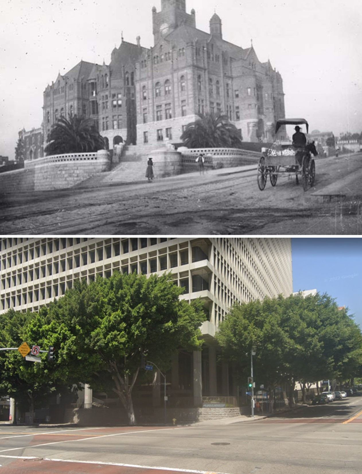 |
|
| (1891 vs 2022)* - Looking toward the southwest corner of Spring and Temple streets. Top photo shows the old Los Angeles County Courthouse on Poundcake Hill, today the site of the Clara Shortridge Foltz Criminal Justice Center. Photo comparison by Jack Feldman. |
* * * * * |
Historical Early Views
Newest Additions
Early LA Buildings and City Views
History of Water and Electricity in Los Angeles
* * * * * |
References and Credits
^ LA Public Library Image Archive
*^ Wikipedia: Los Angeles High School:
#* OUTPOST – Preserving Historical Data by W. S. Broke
^# California State Library Image Archive
*# Paradise Leased: St. Athanasius
^* Noirish Los Angeles: LA County Courthouse
*#*KCET: A Brief History of Bridges in Los Angeles County
< Back