Early Los Angeles City Views (1800s)
Historical Photos of Early Los Angeles |
 |
|
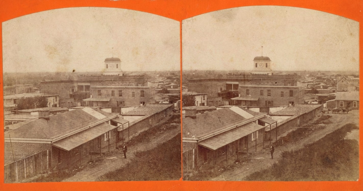
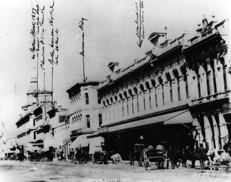
| (ca. 1869)* - Stereoscopic view looking southeast from the slope of Poundcake Hill showing adobe buildings along New High Street with a rifleman standing in the roadway. An ox team is seen heading west on Temple Street. Temple Block, with its prominent clock tower, is visible in the background. |
Historical Notes In the late 1860s Los Angeles was still a small frontier town with a reputation for disorder and violence. The population was only a few thousand people and the city often made national headlines for its high murder rate. Many residents carried rifles or pistols for personal safety, which is why armed men can sometimes be seen in early street scenes. The unpaved roads, the scattered adobe buildings, and the general openness of the area in the photograph reflect the simple and rugged character of the town. From the slope of Poundcake Hill, the view looks toward New High Street and Temple Street, where both homes and small businesses stood side by side. Ox teams were a common sight on Temple Street, which served as an important east west route for hauling goods and supplies. Life here moved slowly, and most of the activity centered on a few key streets that connected civic, commercial, and residential areas. |
 |
|
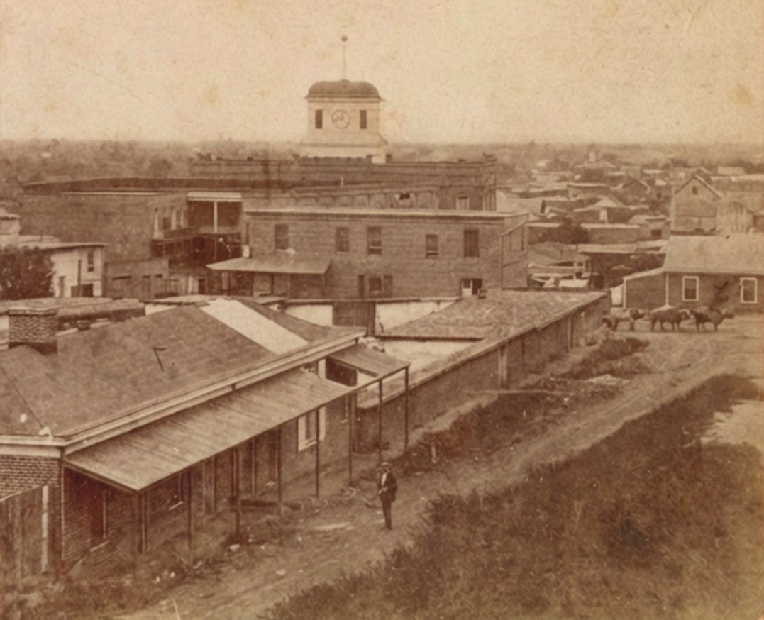
| (ca. 1869)* – View of New High Street (later incorporated into Spring Street) showing a rifleman in the roadway near the corner of New High and Temple Streets, with the Allen Block in the foreground and the Clocktower Market and Courthouse rising behind it. |
Historical Notes This corner of New High and Temple Streets was one of the earliest centers of public life in Los Angeles. It stood only a short walk from the first city hall and jail, which were simple adobe structures used by city leaders, law officers, and guards. Crime was a frequent challenge for the city, and law enforcement was stretched thin. It was not unusual to see armed men in the streets, especially near government buildings, which were gathering points for court cases and disputes. The Allen Block, visible in the foreground, was one of the first brick commercial buildings in the area. Its construction marked the city’s gradual shift from adobe buildings to more substantial architecture. Behind it stands the Temple Block and its well known clock tower. This cluster of buildings housed lawyers, shopkeepers, and the early county courthouse, making this intersection one of the busiest and most important places in the city. |
 |
|
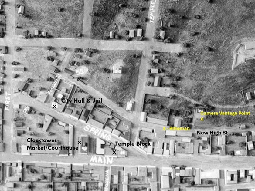
| (1850s)*- Annotated image of a model of early Los Angeles showing the location of the rifleman on New High Street seen in the earlier photograph, along with the Temple Block, the Clocktower, and the approximate camera vantage point. Photo annotation by Jack Feldman. |
Historical Notes This model helps show how small Los Angeles was in the 1850s and how concentrated public activity was around the Temple Block area. The rifleman seen in the earlier photograph stood near the heart of the young civic center, surrounded by adobe homes, simple stores, and dirt streets. The early courthouse and government offices in the Temple Block handled everything from land disputes to conflicts between ranchers, merchants, and new arrivals seeking opportunity in Southern California. The model also gives a clear sense of how the camera views were positioned. Early photographers often set up their equipment on hillsides, rooftops, or open lots because the town was still lightly developed. These elevated angles allowed them to document the growing city and the everyday life of its residents. |
 |
|
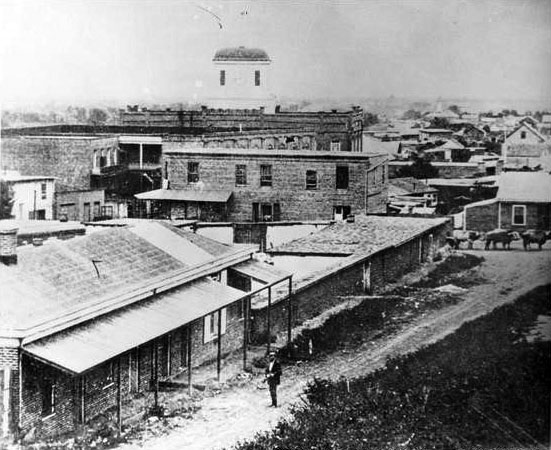
| (ca. 1869)* – Black-and-white version of the view showing a rifleman standing in the roadway near the corner of New High and Temple Streets, with the Allen Block in the foreground and the Clocktower Market and Courthouse rising behind it. |
Historical Notes This image again shows the daily activity at New High and Temple Streets during a time when Los Angeles was transitioning from a frontier settlement to an organized American city. The presence of a man holding a rifle reflects both the unpredictable nature of the town and the fact that many people felt the need to protect themselves. Law officers worked from nearby offices and the jail, but they often lacked the staff and resources to control every disturbance. The Allen Block and the Clocktower Market and Courthouse continued to anchor this busy intersection. Lawyers, clerks, merchants, and local residents all passed through this area, making it a crossroads where public business and private errands came together. Over time this corner became the foundation of the city’s future civic center, even as the surrounding streets remained rough and undeveloped. |
* * * * * |
Temple Block and the Clocktower Courthouse (1869–1876)
 |
|
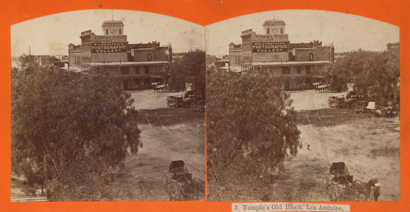
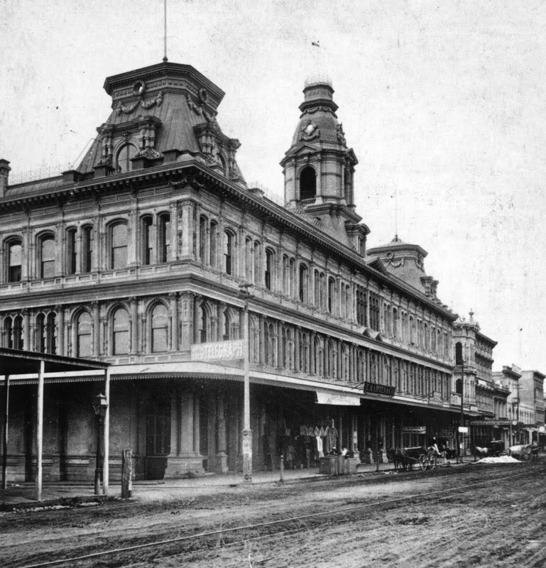
| (1869)* – Stereoscopic view looking south on North Main Street toward Temple Street and its intersection with Spring Street. At the junction stands the two-story adobe Temple Block, with a four-story brick commercial building rising directly behind it. Signs on the upper building read E. B. Frink and Co. Real Estate Agents and Wolfenstein’s Photographic Gallery. The Clocktower Market and Courthouse can be seen further back. Horses and wagons line the unpaved street. Photo by W. M. Godfrey. |
Historical Notes In 1869 the Temple Block area was the center of government and business activity in early Los Angeles. Most buildings were still made of adobe, but brick structures had begun to appear around Main and Spring Streets. The Clocktower Courthouse seen here was the fifth location used by Los Angeles County since 1850, when California became a state. Before moving into the Temple Block in 1861, the county courthouse had already occupied several temporary homes, including rented rooms in the Bella Union Hotel, the home of attorney Benjamin Hayes, and the Roche or Rocha House on Spring Street. The move into the Temple Market Block marked the start of a more stable period of county government during a time when the city was still rough, dusty, and only lightly settled. |
 |
|
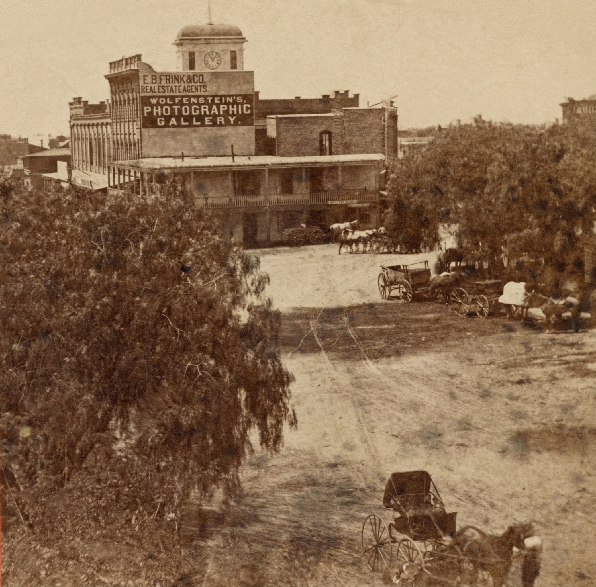
| (1869)* – Right panel of the previous stereoscopic image showing Main Street looking south toward Temple Street and its intersection with Spring Street. The adobe Temple Block sits at the junction, with a four-story brick commercial building rising behind it. The signs for E. B. Frink and Co. and Wolfenstein’s Photographic Gallery are clearly visible. The Clocktower Market and Courthouse stands farther back. Photo by W. M. Godfrey. |
Historical Notes This view shows the busy activity around the Main and Temple intersection. The simple adobe buildings in front contrast with the larger brick structures that were beginning to define the growing business district. Just beyond the adobe is the Clocktower Courthouse, which served the county from 1861 until 1891. Market Street ran along the north side of the courthouse, and Court Street ran along the south side, giving the building its central role in public life. During these years Los Angeles was slowly shifting from a frontier town into a small American city. The courthouse handled cases involving land claims, disputes among ranchers, and conflicts between newcomers and long-time residents. Horse drawn wagons and unpaved roads were still part of daily life. |
 |
|
| (1869)* - View looking east toward the old Los Angeles County Courthouse in the Temple Block. This was the county’s fifth courthouse location. Market Street ran between Main and Spring Streets along the north side of the Clocktower Courthouse, while Court Street ran along its south side. |
Historical Notes Through more than 150 years the county has used at least eight buildings as its county courthouse. All have been situated within a mile of each other in downtown Los Angeles south of the original plaza in what has for the past 80 years been called the Civic Center. ◆ The first county courthouse was in the adobe Bella Union Hotel, where court was held in rented rooms from 1850 to 1852. |
 |
|
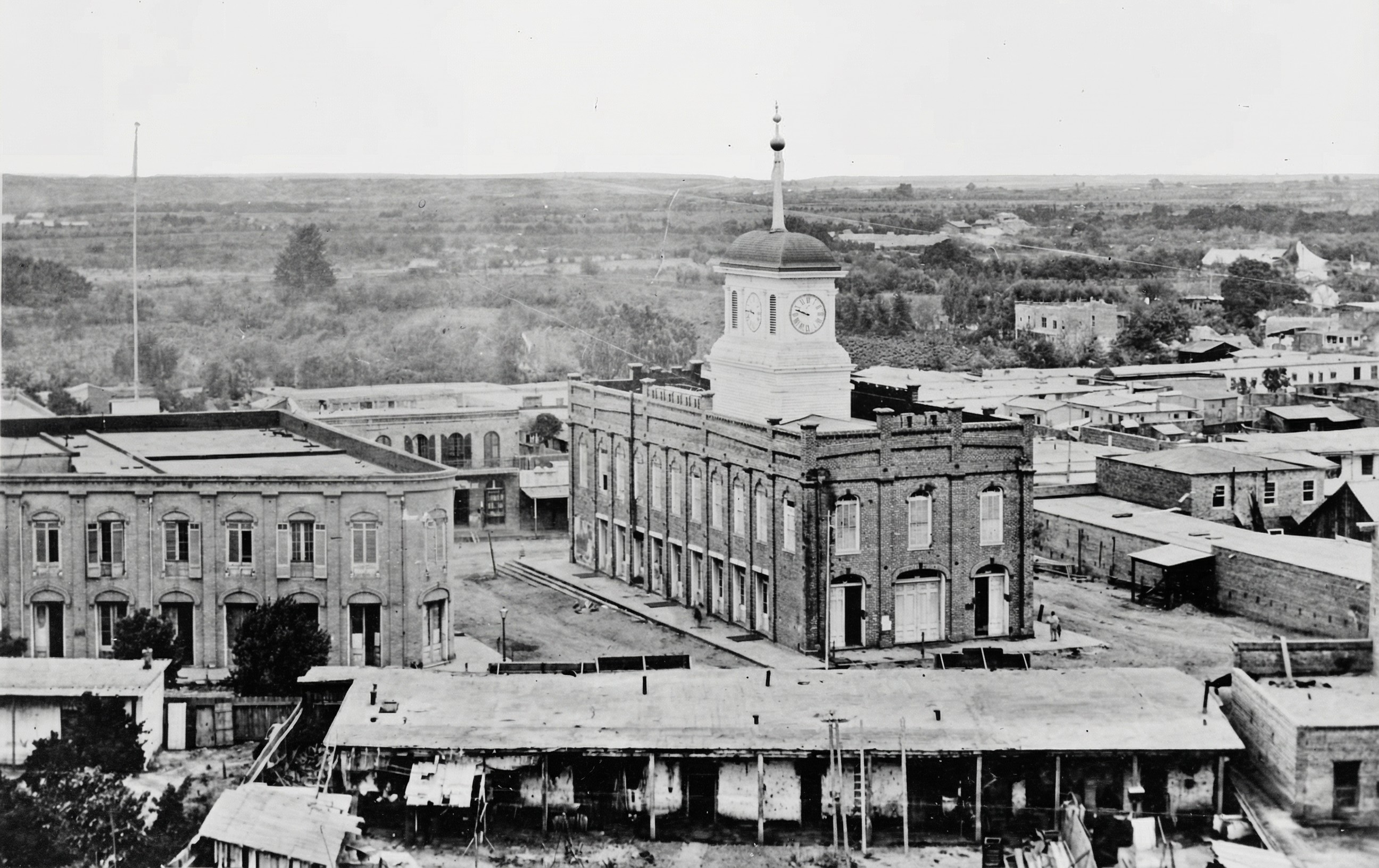
| (1876)* - Elevated view of the Clocktower Market and Courthouse in the Temple Block, the main county government center located one block east of the first city hall and jail. |
Historical Notes By 1876 the Temple Block had become the heart of public activity in Los Angeles. Jonathan Temple, one of the city’s earliest merchants and civic leaders, had developed the block in the 1850s and 1860s with shops, offices, and the Market House, which later became the courthouse. The tall clock tower was one of the city’s first visible landmarks and appeared in many early photographs. The courthouse continued in use until 1891, when the county moved into the new red sandstone courthouse on Poundcake Hill. After the Long Beach earthquake of 1933, that building was removed, and today the site is occupied by the Foltz Criminal Justice Center. This early view shows the city at a time when most of the surrounding area was still open land. Within a few decades, this district would become the center of the modern Los Angeles Civic Center, home to city hall and other major public buildings. Click HERE to see more early views of the Temple Block. |
* * * * * |
The First City Hall and Jail of Los Angeles (Rocha Adobe)
.jpg) |
|
| (1850s)* - Model of early Los Angeles showing the first city hall and jail at center-left on the northwest corner of Spring and Franklin (formerly Jail) Streets. |
Historical Notes This model represents the heart of Los Angeles as it appeared in the early 1850s. The first city hall and jail stand at the northwest corner of Spring and Franklin Streets. At this time Spring Street was known as New High Street, and Franklin Street was called Jail Street because the jail stood at its eastern end. The hill behind the building is Poundcake Hill, later the site of the 1888 County Courthouse. To the right are Temple Block and the Clocktower Market and Courthouse, which formed the center of civic life in early Los Angeles. The model shows how small and closely packed the young city was during its earliest years. |
 |
|
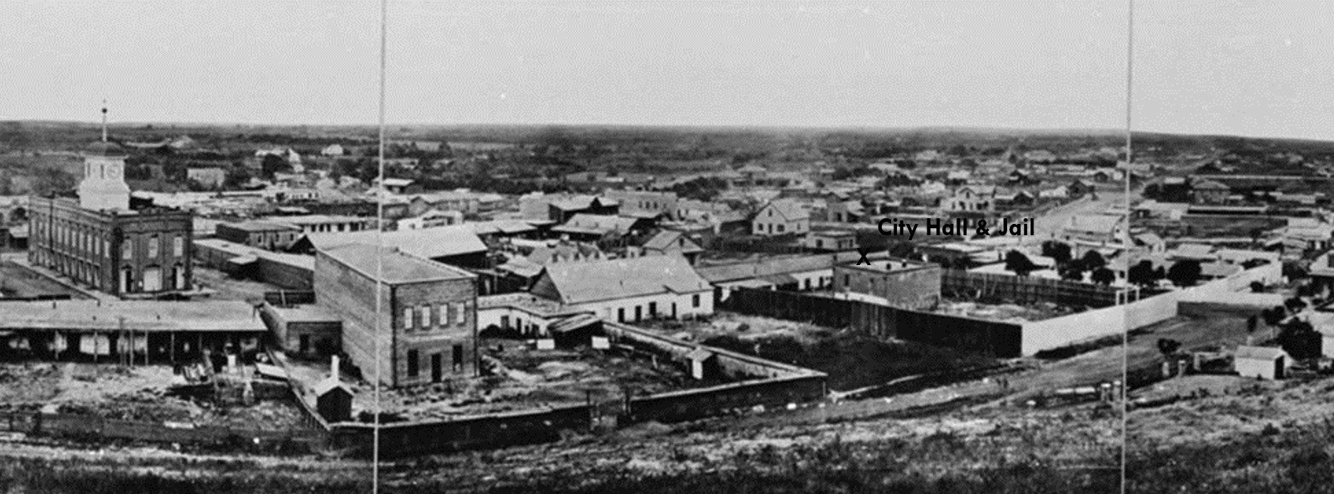
| (ca. 1869)* - Composite panoramic view showing the first city hall and jail at the corner of Spring and Jail Streets, with the adobe city offices along Spring Street and the brick jail standing in the yard behind it. |
Historical Notes This view shows the full first city hall and jail complex at the northwest corner of Spring and Jail Streets. The adobe fronting Spring Street served as the city offices. Behind it stands the two-story brick jail. The open yard between the buildings held prisoners and was the site of early executions. Because vigilantes sometimes stormed the jail, the tall fence around the yard was built mainly to keep angry crowds out. The Clocktower Market and Courthouse on Temple Block appears at left. Few images capture this important early civic corner as clearly as this one. |
 |
|
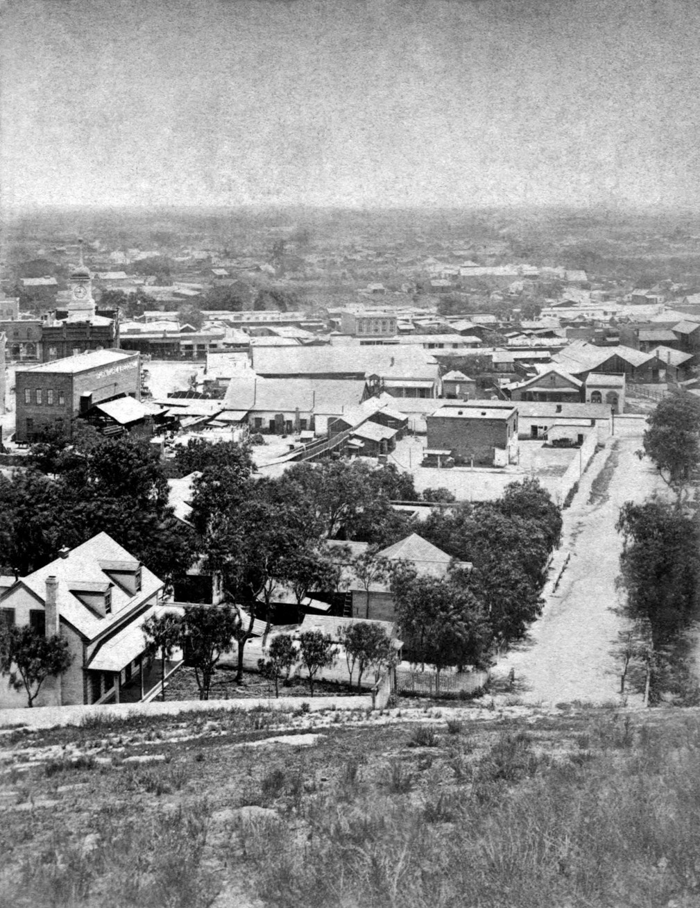
| (ca. 1875)* - View looking east down from Poundcake Hill showing Franklin Street (originally Jail Street) as it intersects with Spring Street. LA’s first designated Jail (brick building) sits near the northwest corner. The long building it sits behind is the Rocha Adobe on Spring Street which also served as LA’s first City Hall. The Temple Block clock tower is visible at upper left. |
Historical Notes This view shows the first city hall and jail complex from the hillside west of Spring Street. The long adobe on Spring Street originally served as the home of Antonio José Rocha and was used as the city offices in the eighteen fifties and sixties. Behind it stands the two-story jail, with adobe walls on the lower level and brick above. The small white outhouse at the southwest corner of the yard is clearly visible. Executions were carried out in the jail yard, and residents often stood on the hill behind the jail to watch the proceedings. This photograph highlights the compact layout of the early civic center. |
 |
|
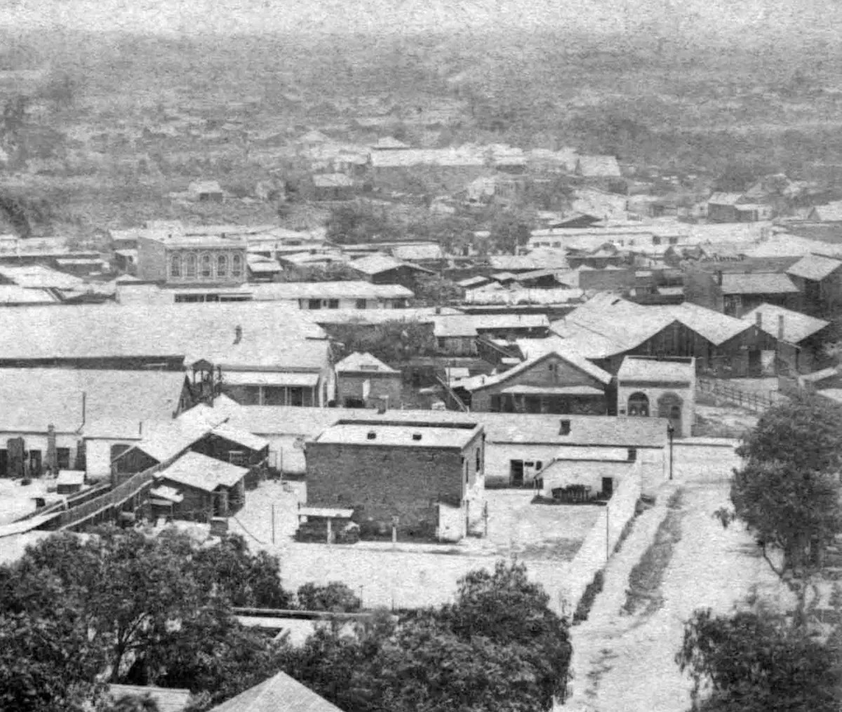
| (ca. 1875)* - Henry T. Payne stereoscopic view from the hillside west of Spring Street showing the Rocha Adobe with the brick jail building in the yard behind it. |
Historical Notes This stereoscopic view by photographer Henry T. Payne shows the first city hall and jail complex from the hillside west of Spring Street. The long adobe on Spring Street originally served as the home of Antonio José Rocha and was used as the city offices in the eighteen fifties and sixties. Behind it stands the two-story jail, with adobe walls on the lower level and brick above. The small white outhouse at the southwest corner of the yard is clearly visible. Executions were carried out in the jail yard, and residents often stood on the hill behind the jail to watch the proceedings. Payne’s view, with its stronger stereoscopic depth, underscores the compactness of this early civic center. |
 |
|
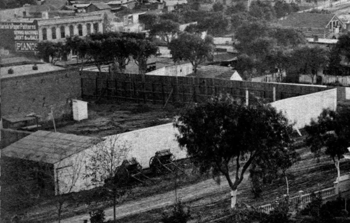
| (ca. 1875)*- Detail view of the fenced jail yard behind the former Rocha Adobe, showing the white outhouse and the two-story city and county jail building. |
Historical Notes This closer look at Spring Street captures the jail yard behind the adobe city offices. The tall fence surrounding the yard was built to protect the jail from intruders rather than to prevent escapes. The two-story jail building, adobe below and brick above, stands directly behind the yard. A commercial building on the east side of Spring Street is visible at upper left, displaying painted signs for clothing patterns, sewing machines, and pianos. The scene reflects the mix of civic and commercial activity that filled this small area of the city. |
 |
|
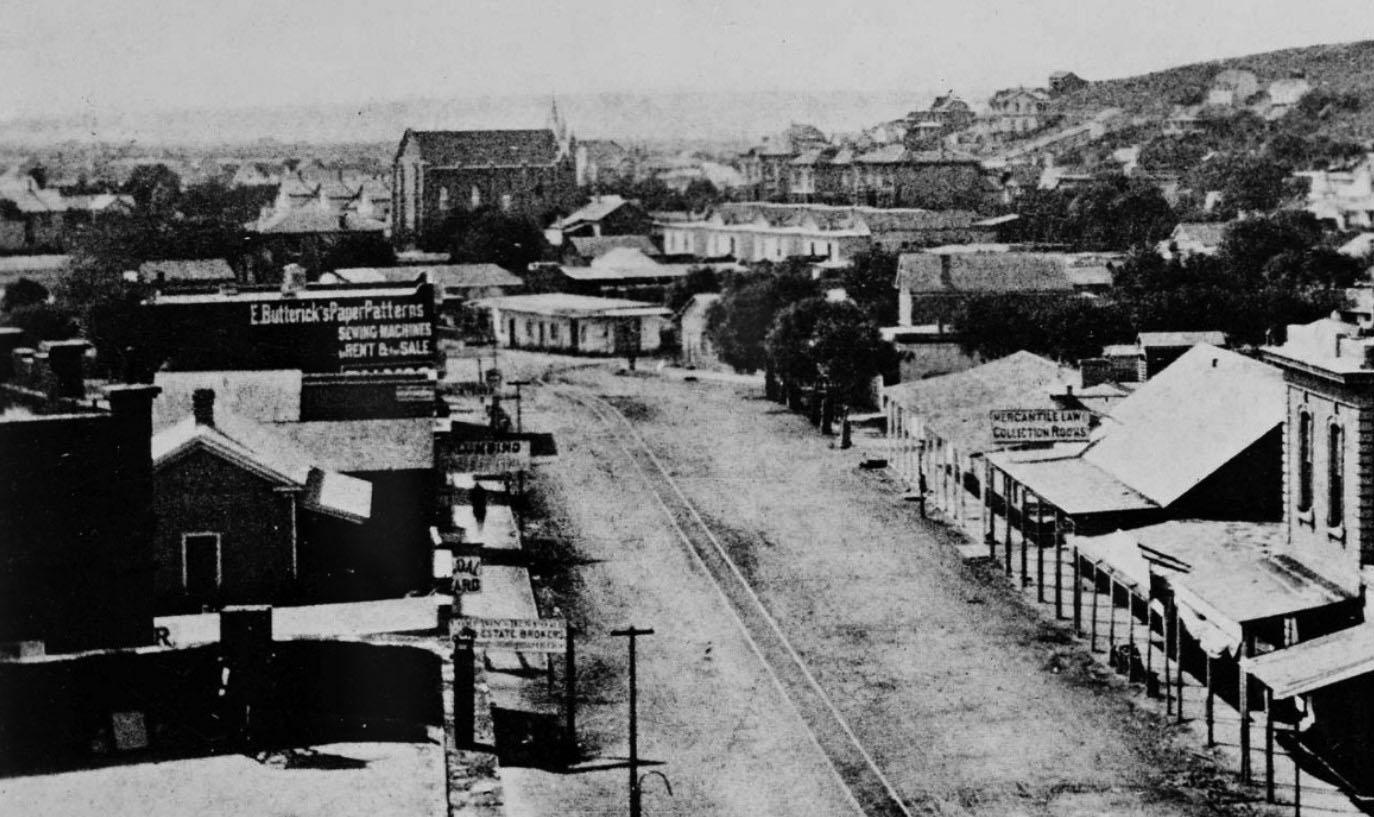
| (1874)* – View looking south on Spring Street as seen from the top of the Clocktower Market/Courthouse building. To the right of center is a building with a steep roof and a sign that says “Mercantile Law Collection Books.” The building immediately south of that, on the northwest corner of Spring and Franklin Streets, is the first Los Angeles City Hall and jail, a building the city and county shared. The taller building in the distance, near the top center of the photo, is the City's 1st Synagogue, built in 1873. |
Historical Notes In August 1853, an adobe home that had been built in the 1820s at the northwest corner of Spring and Franklin Streets – a site now under the current city hall – was sold by John Temple to the city and to Los Angeles County for a city hall and courthouse. The city owned a one-quarter interest in the property, and the county owned a three-quarters interest. A brick jail used by both the city and county was constructed behind the adobe in 1853-54, the first (non-adobe) brick building built in Los Angeles. |
Rocha Adobe
 |
|
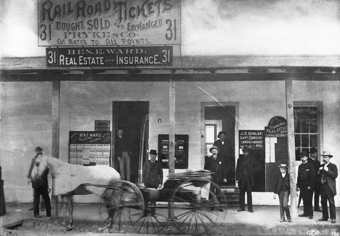
| (ca. 1880)* - View showing the first Los Angeles jail and city hall, west side of Spring Street on the corner of Franklin Street. A group of men and a boy stand in and around the doors under the roof overhang of the 1-story building. A horse-drawn wagon moves by going to the left. The address above is 31 and 33 Spring Street. |
Historical Notes By the 1880s the original city hall and jail had been converted into storefronts. The adobe stood on the northwest corner of Spring and Franklin Streets and was originally built as a residence by Antonio José Rocha. Signs advertise real estate, insurance, railroad tickets, and auction services. Several men and a boy stand beneath the porch roof while a wagon passes by. Although no longer serving its original purpose, the building remained a familiar landmark until it was demolished as downtown Los Angeles expanded. Originally built in the 1820s as a residence by Antonio Jose Rocha and deeded to the city in 1855 by Rocha, Buenaventura Lopez, his wife, Jose Jorge Rocha, Guadalupe Valez, and his wife. Later used as a railroad ticket office and real estate office. The businesses advertised are "Ben. E. Ward, real estate and insurance", "Pryke & Co., railroad tickets bought, sold and exchanged, cut rates to all points", "Potts and Covarrubias, real estate agent, general auctioneer" and "J. D. Dunlap, general commission, lands & houses for sale or rent". Mr. Dunlap was also a Deputy Marshall. The following historical timeline lists the buildings used by City Council, also known as City Hall, since 1850, when Los Angeles was incorporated as a municipality: ◆ 1850 - 1853 - used rented hotel and other buildings for City meetings ◆ 1853 - rented adobe house (aka Rocha Adobe) on Spring Street - across from current City Hall (now parking lot for Clara Shortridge Foltz Criminal Justice Center). The buliding was shared with the County who used it as a Court House. ◆ 1861 - moved into John Temple's Clocktower Market Building, but only stayed for less than a year before the County Court House moved-in ◆ 1861 - 1884 - relocated back to the Rocha Adobe and stayed for over 20 years ◆ 1884 - 1888 - moved to new City Hall Building at South Spring Street and West 2nd Street (site of current Los Angeles Times Building) ◆ 1888 - 1928 - moved to new Romanesque Revival Building on 226-238 South Broadway between 2nd Street and 3rd Street; demolished in 1928 and now site of parking lot between LA Times Parking structure and 240 Broadway. ◆ 1928 - moved to current City Hall Building |
* * * * * |
McDonald Block
 |
|
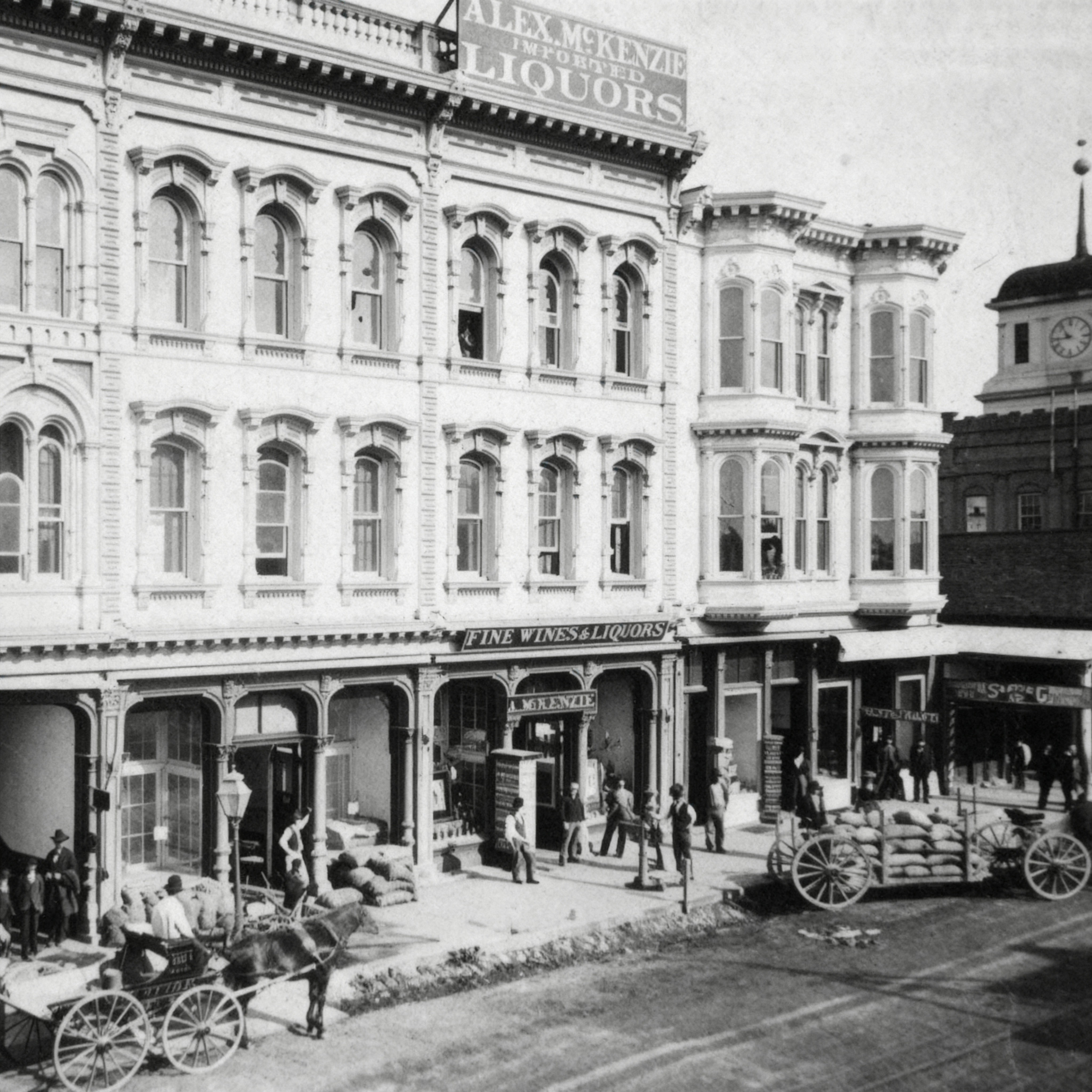
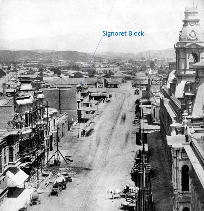
| (1876)* - View of the Old McDonald Block at 127 North Main Street between First and Court Streets. Temple’s old courthouse building with its clock tower appears in the background. |
Historical Notes The McDonald Block stood at 127 North Main Street, on one of the busiest stretches of Los Angeles during the 1870s and 1880s. Built in the mid 1870s and attributed to architect Ezra Kysor, it was an early brick commercial block with an Italianate facade, tall arched windows, and a cast iron storefront. It marked the city’s transition from a frontier town of adobe buildings into a more modern business district. The ground floor contained a number of retail businesses typical of the era, including Alex McKenzie’s Wines and Liquors, the Grange Store, and Park Millinery Goods. The second floor housed the offices of Judson, Gillette and Gibson, well known for their work in real estate and title examination, as well as the offices of Kysor and Hennessey. The third floor, known as McDonald Hall, served as a meeting and assembly room used by civic groups and, for a time, a Masonic lodge. In 1880 the first meetings of the Los Angeles Athletic Club were held in the law offices on the second floor, with James B. Lankershim among those present. Although long since demolished during the development of the Civic Center, surviving images of the McDonald Block provide a valuable record of early Main Street and the architectural and commercial growth of nineteenth century Los Angeles. |
 |
|
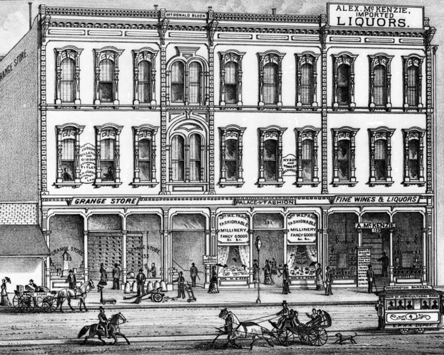
| (1880s)* - Lithograph of the McDonald Block at 127 North Main Street between First and Court Streets. |
Historical Notes The McDonald Block was one of the more substantial commercial buildings on Main Street in the late 1870s and 1880s. Built in the mid 1870s and attributed to architect Ezra Kysor, it featured a three story Italianate facade with tall arched windows, bracketed cornices, and a cast iron storefront. Its appearance marked an early move toward brick and iron construction as Los Angeles began to shift away from its earlier adobe character. The lithograph shows the building in its prime, with the full Main Street frontage visible. The ground floor housed several shops, including McKenzie’s liquor business, the Grange Store, and Park Millinery Goods. Upper floors contained professional offices, such as the law firm of Judson, Gillette and Gibson and the architectural offices of Kysor and Hennessey. The top floor, known as McDonald Hall, served as a meeting space for civic groups and fraternal organizations. The building also holds a place in the early social history of Los Angeles. In 1880 the first organizational meetings of the Los Angeles Athletic Club were held in the second floor offices, with James B. Lankershim among the founders. The McDonald Block remained an important address into the 1890s before changes to the Civic Center resulted in its removal. Today only images like this lithograph preserve the appearance of this early commercial landmark on Main Street. |
* * * * * |
Signoret Block
 |
|
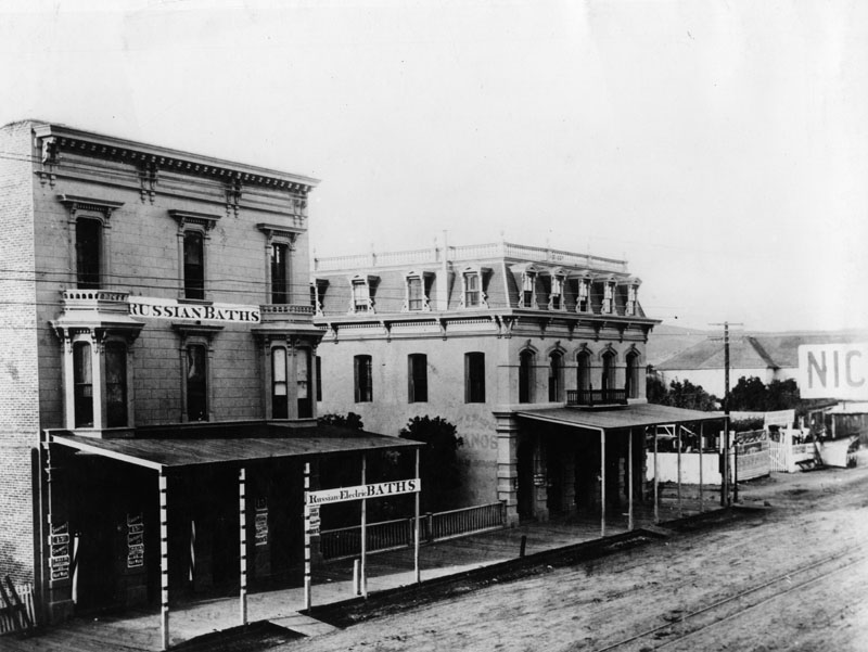
| (ca. 1881)* - Photograph of a view looking north along Main Street near the Los Angeles Plaza showing the Signoret Block. A three-story brick building stands in the left foreground along the unpaved street advertising "Russian Electric Baths" and features bay windows on the second floor as well as an overhang that shades the sidewalk in front of it. A second, similarly-constructed building stands farther in the background down the road and features gingerbread trim. Hills can be seen in the distance. Legible signs include: "Shaving 15¢", "Shampooing 25¢", "Hair Cutting 25¢", "Hair Work", "15 Russian Steam and Electric Baths", "Other Medicated Baths", and "Mrs. Huck's Dressmaker / Modes de Paris". |
Historical Notes Felix Signoret was born in France on June 9, 1825, living in Marseilles before he came to the United States. By trade he was a barber, later an apartment owner. He bought a parcel of land at 125 Aliso Street in 1871 and built a "substantial brick house" about thirty feet wide with an area of nearly 1,800 square feet; the roof was "hipped on all four sides in mimicry of the fashionable Mansard shape. . . . By 1888 the Signorets . . . were long gone, and their genteel house was used as a brothel." Signoret was elected to the Los Angeles Common Council, the governing body of the city, serving from May 9, 1863, to May 5, 1864. He was also a member of the Los Angeles County Board of Supervisors in 1866. He is also known for having led a lynch mob that hanged five people in Los Angeles in 1869–70 in the aftermath of a murder resulting from 'offensive remarks (made) about the newly organized French Benevolent Society.' In 1874, Signoret built a new hotel at Main and Turner streets, north of Arcadia Street and "opposite the Pico House," also with a Mansard pitch, which the Los Angeles Star said would be the first such roof in the city. |
 |
|
| (ca. 1880)* - Looking north on Main Street from top of the Downey Building located just south of the Baker Block showing the location of the Signoret Block, across the street fromthe Pico House. |
* * * * * |
Spring Street (1870s)
 |
|
| (1876)^ - On Spring near First Street. Stage depot/livery stable at left offering horse shoeing had once served as headquarters for the Butterfield Overland Stage, which arrived in Los Angeles for the first time in 1858. |
Historical Notes In 1876, the year this picture was taken, a land boom developed in Santa Monica. Stagecoaches to the beach were abandoned in favor of the Los Angeles & Independence Railroad , which carried passengers for $1 a round trip, arranging their schedules to allow time for riders to swim, picnic or buy lots in the growing community. The Butterfield Overland Stage headquarters site has been designated as California Historical Landmark No. 744. Click HERE to see more of the California Historical Landmarks in LA. |
 |
|
| (1876)^^ - Fourth of July, 1876: Los Angeles celebrates the centennial of American independence with a parade down a dusty Spring Street. |
* * * * * |
Main, Spring, and Temple Streets
 |
|
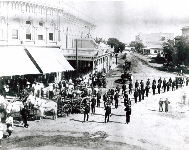
| (ca. 1870s)^^* - This is the earliest known photo of the Los Angeles Volunteer Fire Department. A horse-drawn fire engine followed by uniformed firemen (volunteers) parade at the corner of Main and Spring Streets with the Downey Block on the left. |
Historical Notes Below are two different captions related to this photo: "The first Fire Company was organized on September 30, 1871. The boys are out celebrating the First Anniversary of the occasion with a parade. This is the first known picture taken of the Fire Company. The camera was pointing North from Main and Spring Streets. The Pico House can be seen in the background. The buildings back of the fire engine are on the present site of the Federal Building." - The Firemen’s Grapevine (1961) "The Los Angeles Volunteer Fire Department celebrated its first anniversary, September 30, 1872, with a parade through downtown streets. They paused at Main and Temple Streets, where Photographer V. Wolfenstein captured the scene for posterity in a picture which was to become one of the fire department's most famous through frequent reproductions of it." - A Century of Service (1886-1986) by Paul Ditzel |
 |
|
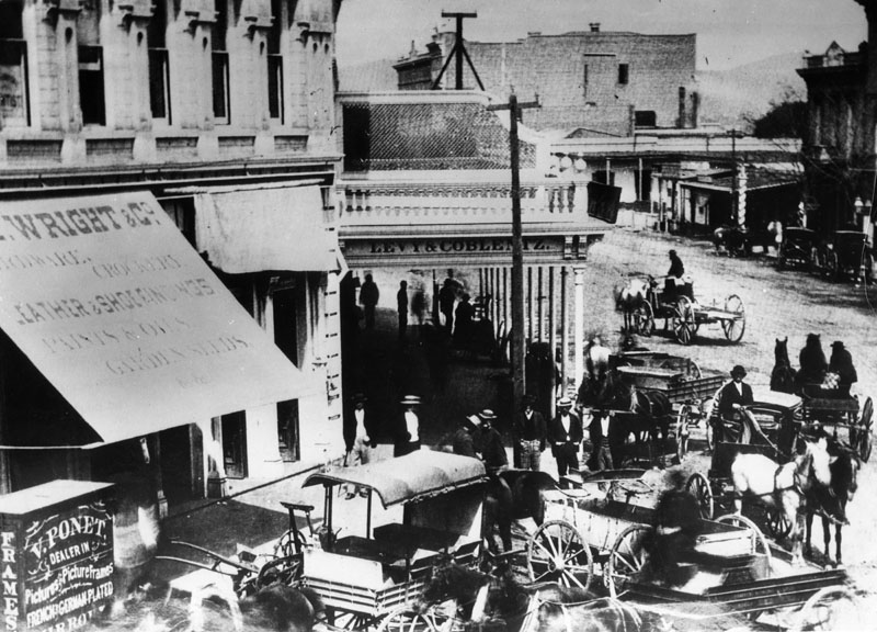
| (ca. 1871)^ - Another view of the corner of Main and Spring Streets, looking north from Temple Street showing the Downey Block. Several horse-drawn vehicles are on the street as well as pedestrians milling around. A sign on the edge of the balcony reads Levy & Coblentz. |
 |
|
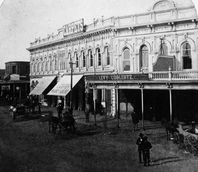
| (1875)^ - View showing the North Main Street side of the Downey Block. Two well-dressed men are standing on the dirt road in front of the building. |
 |
|
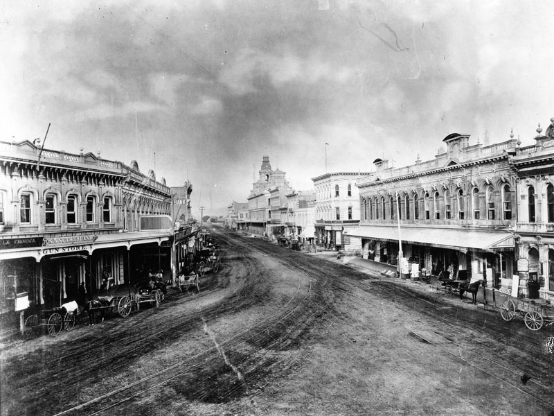
| (ca. 1878)^ - View of Main Street north from Temple Block, about 1878. The photograph was taken before the Farmers and Merchants Bank moved to Main and Commercial Streets in the fall of 1883. On the far right is Commercial Bank, which changed to First National Bank in 1880. A gun store is visible to the left located in the Downey Block. In the distance can be seen the cupola of the Baker Block. |
* * * * * |
Main Street
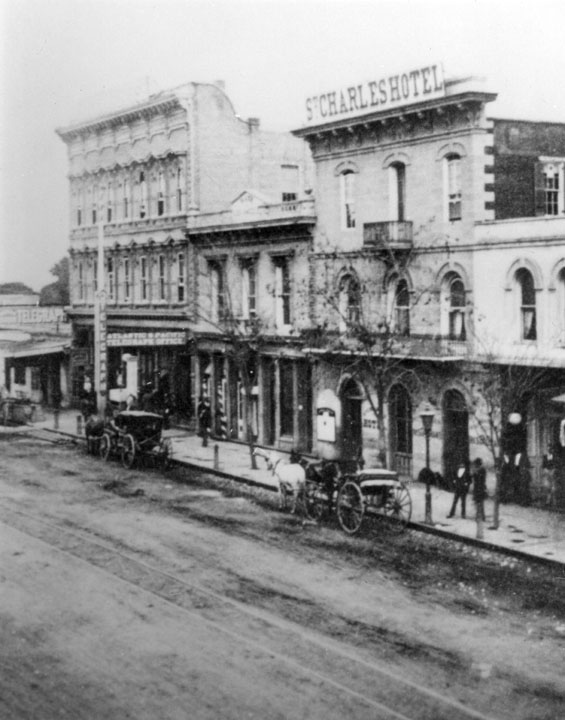 |
|
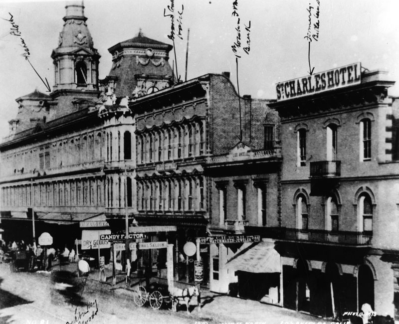
| (1880)^ - St. Charles Hotel, originally the Bella Union Hotel. The Bella Union became the Clarenden in 1873 and the St. Charles in 1875. Pico's building to the left was the original home of the Farmers and Merchants Bank, which later merged into the Security Pacific Bank. Also shown is the Atlantic & Pacific Telegraph Office, in the lower floor of the Backman House. |
Historical Notes The telegraph, invented in 1832 by Pavel Schilling and Samuel Morse, didn't get to Los Angeles until 1860.*^ Phineas Banning helped to bring telegraph lines to Los Angeles. In 1860, telegraph lines were slowly making their way toward Los Angeles from San Francisco. When progress lagged, Banning ordered wire and began building from his end. Starting in Wilmington, of course, the link was completed on October 8, 1860, and Los Angeles was no longer an isolated outpost. Click HERE to see more on Phineas Banning and Wilmington in Early Views of San Pedro and Wilmington. |
 |
|
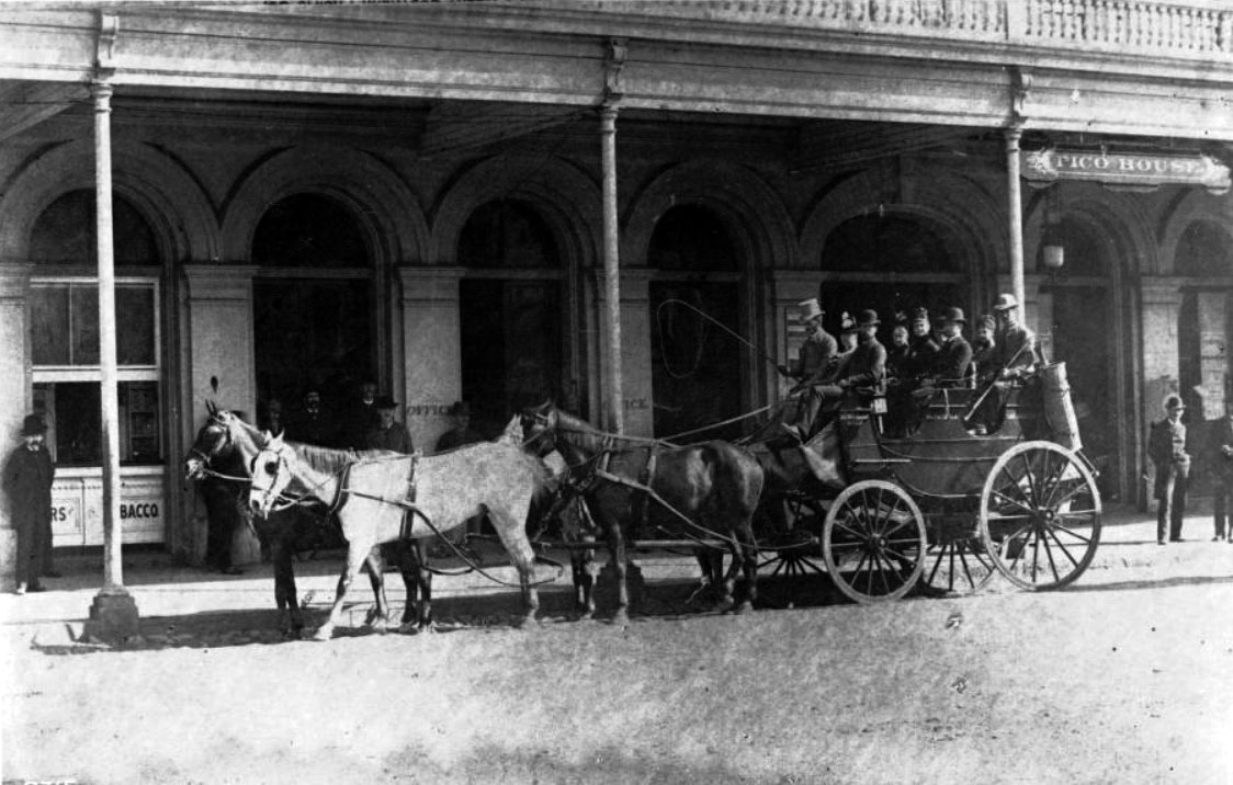
| (1880s)* - View showing a stagecoach (or Tally-ho) parked in front of the Pico House. Nine people sit in the uncovered stagecoach. The driver holds a whip over the hitched team of 4 horses. Nine other people stand on the boardwalk in front of Pico House looking on. |
 |
|
| (ca. 1880)^ - The Pico House, sometimes called "Old Pico House", built by Pio Pico in 1869-70. Standing by the Pico House on the left, horses and carriages are waiting. You can look down the block and see the Merced Theatre next to it, 2 more buildings, and then the towers of the Baker Block. |
Historical Notes Ezra F. Kysor designed the Italianate Merced Theatre, built in 1870 by William Abbott and named for his wife. It opened on January 30, 1871 and is the oldest surviving theater in Los Angeles. Baker Block was completed in 1878 by Colonel Robert S. Baker. |
 |
|
| (1880)^ - Southeast corner of Arcadia and Main Streets. The building with the three distinct towers is Baker Block. |
Historical Notes The ornate three-story Baker Block was constructed by Colonel Robert S. Baker on the corner of Arcadia and Main streets in 1878. It was built on the former site of the residence of Abel Stearns. Arcadia Street was dedicated in 1872. Arcadia Bandini, born in 1823, was the daughter of prominent ranchero Juan Bandini. She came to be regarded as one of the most beautiful belles of Los Angeles and was just 14 when she married 44-year-old Abel Stearns, who had come west from Massachusetts and acquired Southern California's largest land-cattle empire. Stearns built a home for his bride one block south of the Plaza--the community's central gathering area--and the house, called El Palacio, became the social hot spot. In 1858, Stearns constructed a two-story business block on Los Angeles Street nearby and called it Arcadia Block. The street was officially dedicated one year after Stearns' death in 1871. In 1874 Arcadia married Colonel Robert S. Baker (1826–1894), owner of Rancho San Vicente y Santa Monica, and they settled in Santa Monica. The famous Arcadia Hotel in old Santa Monica was also named after her. Click HERE to see the Arcadia Hotel in Early Views of Santa Monica. |
 |
|
| (ca. 1880)^ - View of North Main Street. Baker Block is on the left and the St. Charles Hotel, formerly the Bella Union Hotel, is on the right. |
Historical Notes Constructed in 1835, the Bella Union Hotel (seen above after it became the St. Charles Hotel) has a long, rich history. It served as the County Courthouse until October 1851, and in 1860 was the location of a champagne fete celebrating the connection of San Francisco and Los Angeles by telegraph. |
 |
|
| (ca. 1880)^ - View looking north on Main Street from the Downey Building located just south of the Baker Block on the 300 block of N. Main Street. In the distance can be seen the Old Plaza Church where Main Street veers to the left. Telephone/telgraph lines can be seen on both sides of the street. |
Historical Notes Alexander Graham Bell invented the telephone in the late 1870's and it didn't take long for Los Angeles to adopt the new technology. In 1879, the Los Angeles Telephone Company was formed and it began offering telephone service in the area of what is now Downtown Los Angeles. This was just one year after the very first North America telephone exchange was installed in New Haven, Connecticut (January, 1878). The Los Angeles Telephone Company originally started with only seven subscribers. |
 |
|
| (ca. 1880)^ - View looking north on Main Street from the Downey Building located just south of the Baker Block on the 300 block of N. Main Street. In the distance can be seen the Old Plaza Church where Main Street veers to the left. Telephone/telgraph lines can be seen on both sides of the street. (AI image enhancement and colorization by Richard Holoff) |
Then and Now
 |
|
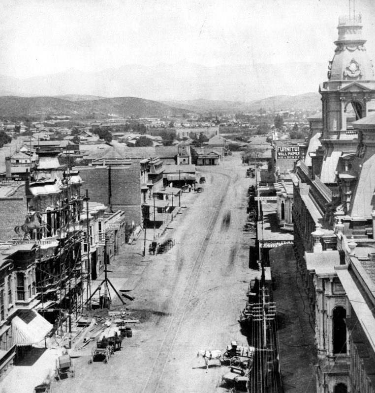
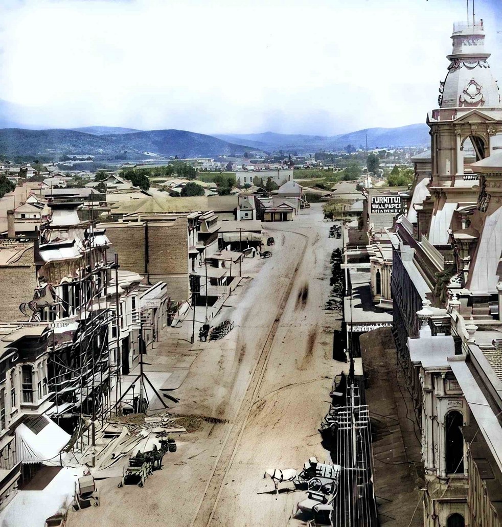
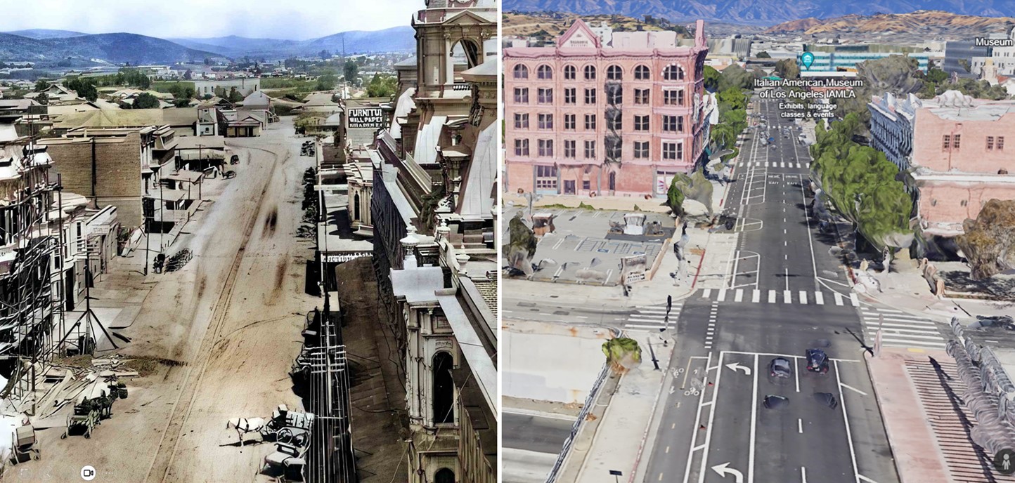
| (1880 vs 2022)* - Looking north on the 300 Block of Main Street. Photo comparison by Jack Feldman. |
|
|
| (ca. 1881)* - Photograph of a view looking north along Main Street near the Los Angeles Plaza showing the Signoret Block. A three-story brick building stands in the left foreground along the unpaved street advertising "Russian Electric Baths" and features bay windows on the second floor as well as an overhang that shades the sidewalk in front of it. A second, similarly-constructed building stands farther in the background down the road and features gingerbread trim. Hills can be seen in the distance. Legible signs include: "Shaving 15¢", "Shampooing 25¢", "Hair Cutting 25¢", "Hair Work", "15 Russian Steam and Electric Baths", "Other Medicated Baths", and "Mrs. Huck's Dressmaker / Modes de Paris". |
Historical Notes Felix Signoret was born in France on June 9, 1825, living in Marseilles before he came to the United States. By trade he was a barber, later an apartment owner. He bought a parcel of land at 125 Aliso Street in 1871 and built a "substantial brick house" about thirty feet wide with an area of nearly 1,800 square feet; the roof was "hipped on all four sides in mimicry of the fashionable Mansard shape. . . . By 1888 the Signorets . . . were long gone, and their genteel house was used as a brothel." Signoret was elected to the Los Angeles Common Council, the governing body of the city, serving from May 9, 1863, to May 5, 1864. He was also a member of the Los Angeles County Board of Supervisors in 1866. He is also known for having led a lynch mob that hanged five people in Los Angeles in 1869–70 in the aftermath of a murder resulting from 'offensive remarks (made) about the newly organized French Benevolent Society.' In 1874, Signoret built a new hotel at Main and Turner streets, north of Arcadia Street and "opposite the Pico House," also with a Mansard pitch, which the Los Angeles Star said would be the first such roof in the city. |
|
|
| (ca. 1880)* - Looking north on Main Street from top of the Downey Building located just south of the Baker Block showing the location of the Signoret Block, across the street fromthe Pico House. |
 |
|
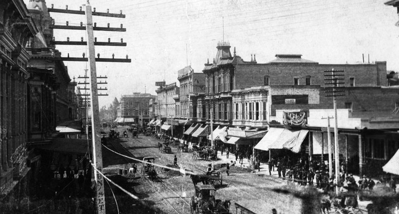
| (1880s)^ - View looking south on Main Street from near the Pico House. Temple Block can be seen in the distance. A large number of people are on the sidewalks and quite a few horse-drawn vehichles are on the street. The population in Los Angeles had grown to 11, 200 by now. Telegraph/Telephone poles and wires are seen on both sides of the street. The wording 'SUNSET' can be read on one side of the pole to the left. |
Historical Notes In 1883, The Los Angeles Telephone Company merged with another local telephone company based in Northern California, Sunset Telephone Company. In 1906, the Sunset Telephone Company was acquired by Pacific Telephone and Telegraph, later known as Pacific Bell. |
 |
|
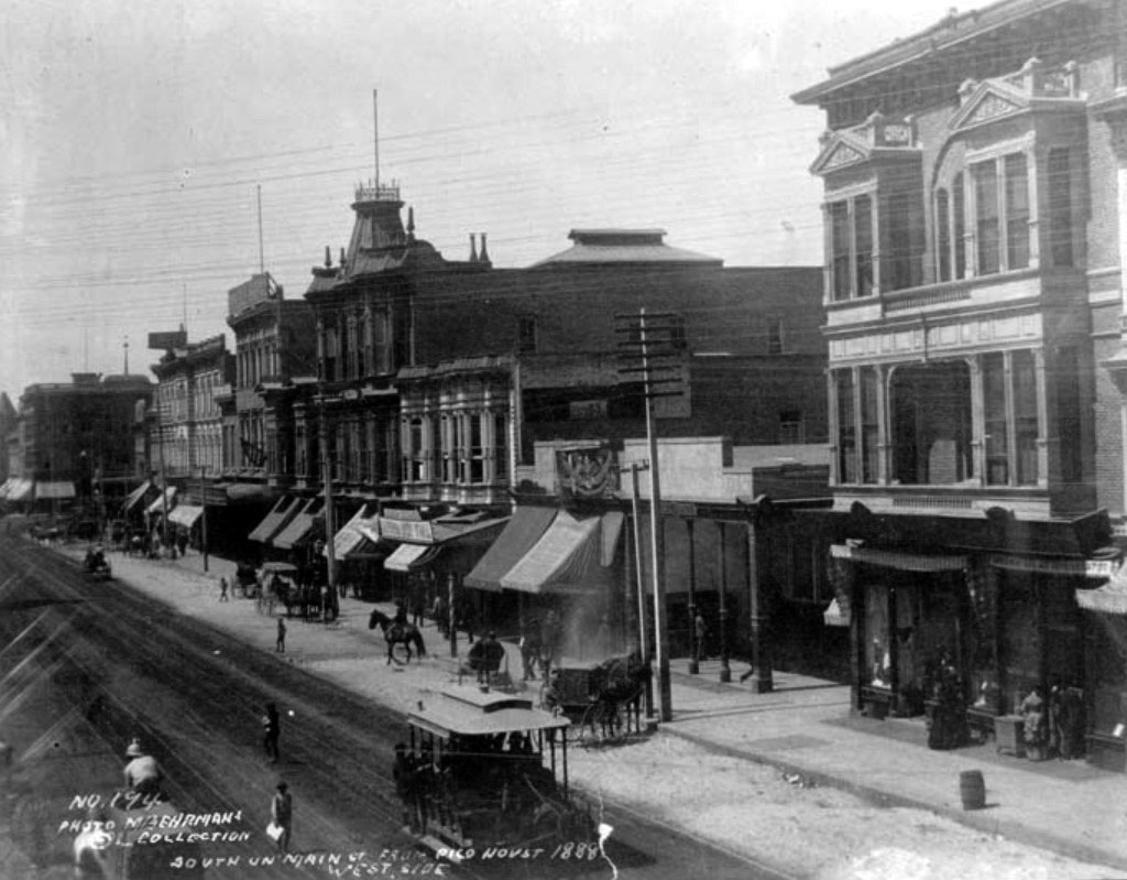
| (1888)* – View looking south, showing the west side of the 300 block of Main Street as seen from the Pico House. A horse-drawn streetcar shares the street with pedestrians, horse-drawn wagons, and a man on horseback (center-left). |
Historical Notes In the 1940s and 1950s, the historic buildings on the 300 block of North Main were demolished to extend Aliso Street from Los Angeles Street to Broadway. Several years later the Hollywood Freeway (Route 101) would be constructed over this new Aliso Street extension. Click HERE to see more in Early Views of the Historic 300 Block of N. Main Street. |
* * * * * |
 |
|
| (1880)^ - View of Los Angeles looking northeast from First Street. The old county courthouse with its distinctive clock tower can be seen at the upper right of photo. |
 |
|
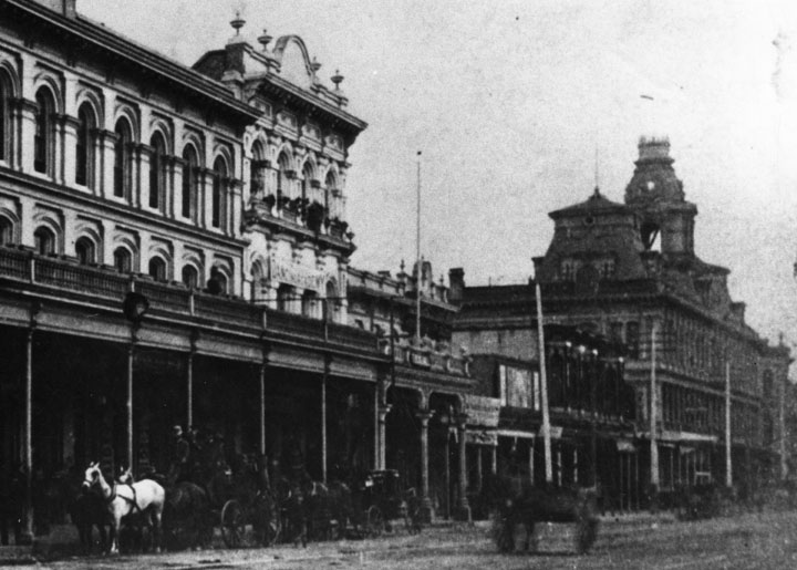
| (ca. 1880)^ - View looking NE as seen from Bunker Hill. Some of the identifiable buildings are the Hotel Des Princes, Farmers and Merchants Bank, the St. Charles Hotel (formerly the Bella Union Hotel), and the magnificent Baker Block, marked by towers and located along Main Street. Aliso Street can be seen running diagonally away from the camera at upper-right. |
Historical Notes The ornate three-story Baker Block was completed around 1877 by Colonel Robert S. Baker. For a number of years, the building housed offices, shops, and apartments. Goodwill Industries of Southern California purchased it in 1919. Despite plans to relocate the structure for another purpose, the city purchased the Baker Block from Goodwill in 1941 and demolished the building a year later. U.S. Route 101 now runs beneath where these buildings once stood.^ |
 |
|
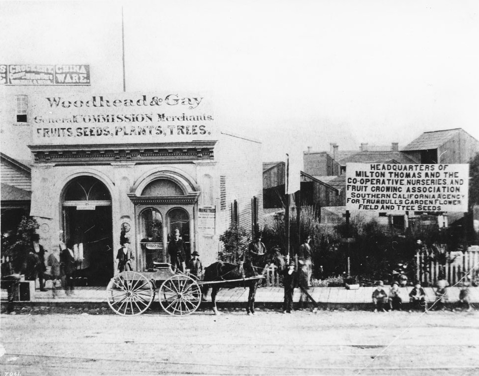
| (ca. 1880)^^ - View of people standing outside the Woodhead & Gay general store, headquarters for Milton Thomas Nurseries, Los Angeles. At center, a man tends a horse-drawn wagon while five children sit to his right on the wooden sidewalk. An overgrown lot to the right of Woodhead & Gay contains the sign for Milton Thomas which reads "Headquarters of Milton Thomas and the Co-operative Nurseries and Fruit Growing Association Southern California Agency for Trumbull's Garden Flower Field and Tree Seeds." |
 |
|
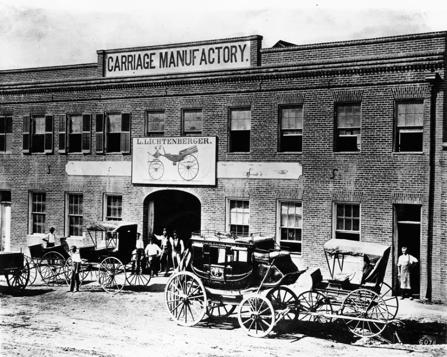
| (1880)^^ - Exterior view of L. Lichtenberger's carriage factory, Los Angeles, 1880. A picture of a carriage and the name L. Lichtenberger is displayed on a billboard-like sign centered in front the building between the first and second floors. At the roof, another displayed sign reads: "Carriage Manufactory". Several carriages are parked out front as a handful of workers pose nonchalantly in front of the building. |
Historical Notes As of 1880 the city of Los Angeles had one large carriage and wagon factory, owned by L. Lichtenberger, that had been in operation since 1864, producing up to 300 vehicles a year. There were also seven other smaller carriage/wagon producers. |
* * * * * |
Spring Street (1880s)
 |
|
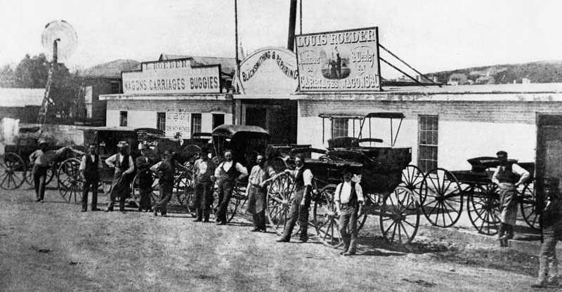
| (1880)* - Men and carriages in front of Louis Roeder’s wagon and carriage dealership near Spring and 2nd Street. The business was located at approximately 85 South Spring Street, just north of 2nd Street. |
Historical Notes By 1880, Spring Street was becoming one of the city’s main commercial corridors. Businesses like Louis Roeder’s wagon and carriage dealership supplied transportation for farmers, merchants, and families at a time when horses and wagons were still the primary way to move people and goods around Los Angeles. Shops like this helped connect the growing downtown with outlying ranches and settlements. |
 |
|
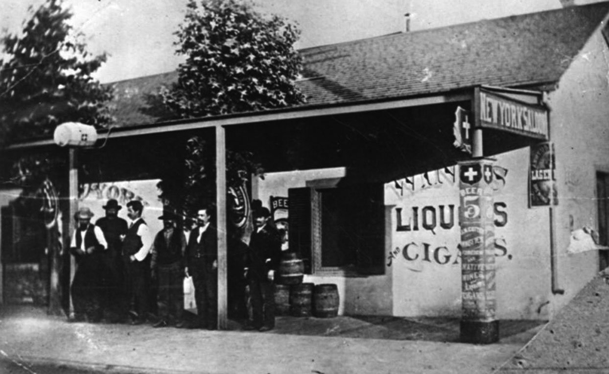
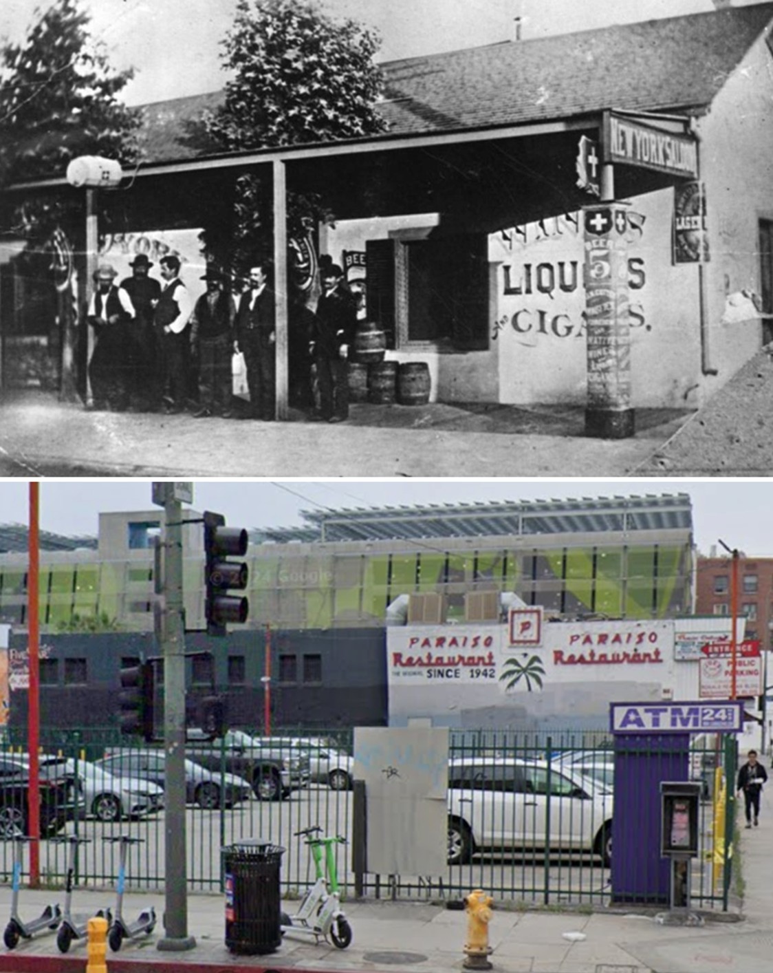
| (1881)* - View of the New York Saloon on the northeast corner of 3rd and Spring Streets, then addressed as 156 South Spring Street. A group of men stands out front while barrels are stacked along the wall. |
Historical Notes Saloons like the New York Saloon were everyday gathering places in early Los Angeles. They offered beer, wine, and spirits, but they also served as informal social hubs where men discussed business, politics, and neighborhood news. The New York Saloon was operated by Gustavus C. Perret, a Swiss immigrant, and ran from about 1881 to 1890. It stood directly across from the New York Brewery, which supplied its beer and operated from the mid-1870s into the 1890s. With nickel beer and simple food, this corner became one of downtown’s liveliest working-class hangouts. |
 |
|
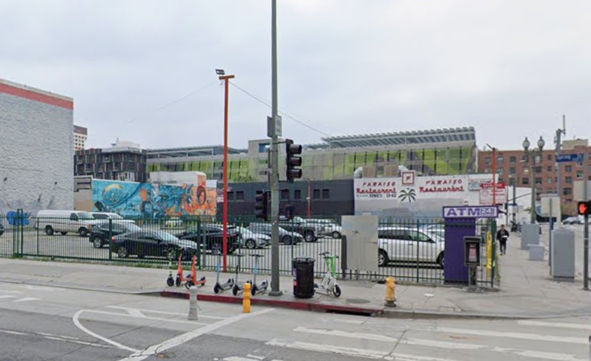
| (2024)* - Looking at the northeast corner of Spring and 3rd Streets, once the home of the New York Saloon, today the site of a parking lot and ATM machine. |
Historical Notes Before 1889, Los Angeles used an earlier street-numbering system, so addresses like 156 S. Spring Street do not match today’s numbers. The corner itself, however, is unchanged — the New York Saloon stood on this same northeast corner during the 1880s, even though the address was later renumbered. |
Then and Now
 |
|
| (1881 vs. 2024)* - The northeast corner of Spring and 3rd Streets, once the site of the New York Saloon, today a parking lot. |
Historical Notes Although Los Angeles renumbered its streets in 1889, the physical location did not change. The New York Saloon occupied this very corner in the 1880s, when Spring Street was becoming one of the city’s busiest commercial and social corridors. |
 |
|
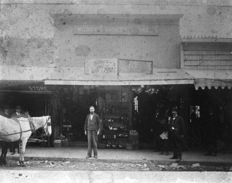
| (1880)* - Exterior view of Moody’s Variety Store on Spring Street between 1st and 2nd Streets. The shop served nearby hotels, boarding houses, and offices in the growing downtown district. |
Historical Notes Variety stores carried an assortment of goods that did not fit neatly into a single specialty. A customer might find stationery, small hardware, household items, toys, and personal accessories under one roof. Shops like Moody’s served nearby boarding houses and offices and helped make Spring Street a convenient place for downtown residents and workers to pick up everyday necessities. |
 |
|
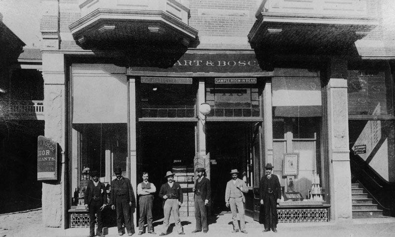
| (ca. 1880s)* - Exterior view of Laggart & Bosch, wholesale liquor dealers on New High Street between Temple and Franklin Streets. This stretch later became part of the north end of Spring Street. A sign advertises a sample room in the rear, next to the law office of J. M. Davidson. |
Historical Notes Wholesale liquor firms like Laggart & Bosch supplied saloons, hotels, and restaurants throughout the growing city. A sample room in the rear allowed buyers to taste products before placing orders. Businesses such as these, along with nearby law offices and other services, show how this part of Spring Street evolved into a mixed commercial district serving both the public and the trade. |
* * * * * |
New High Street (later Spring Street), north of Temple
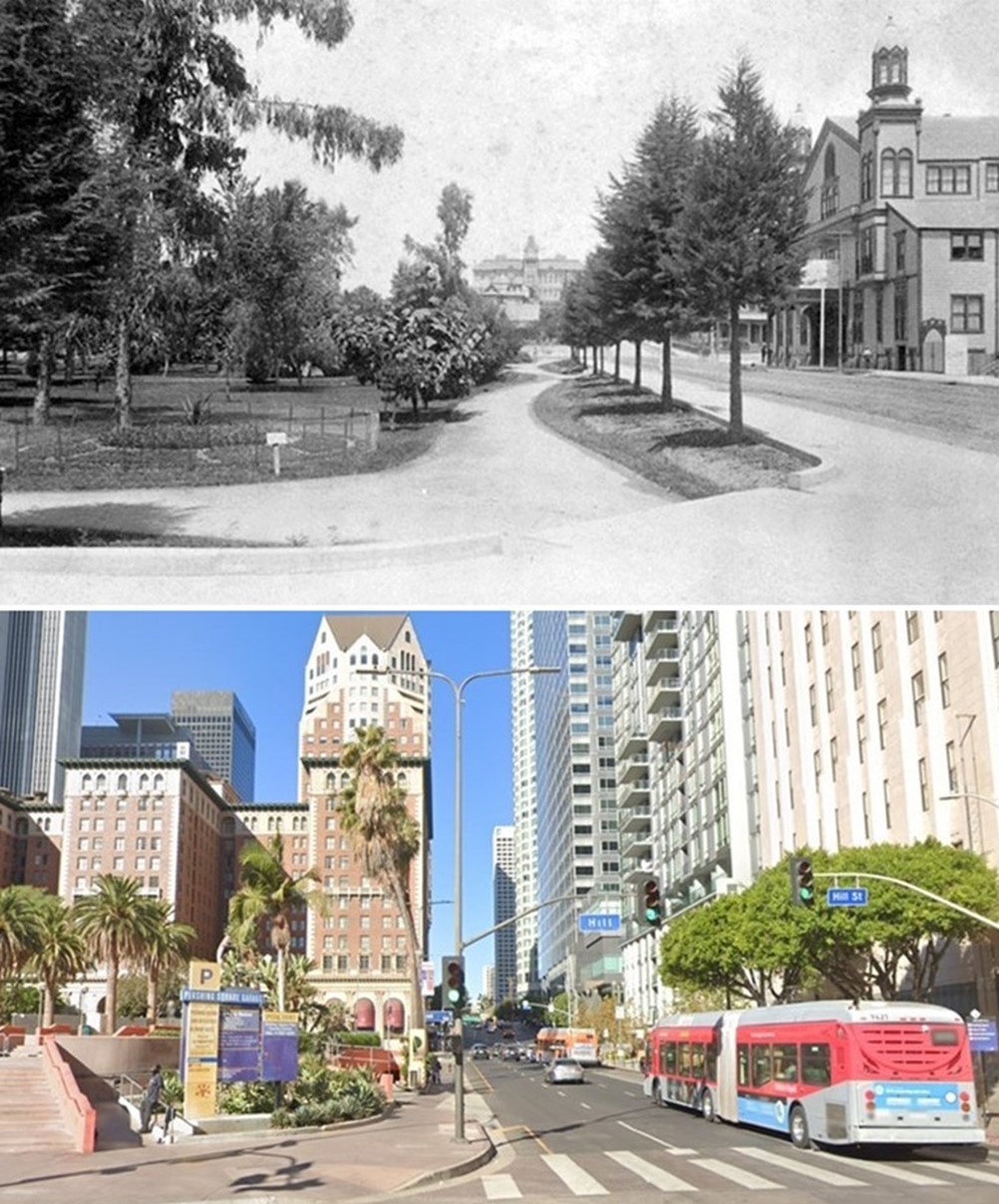
 |
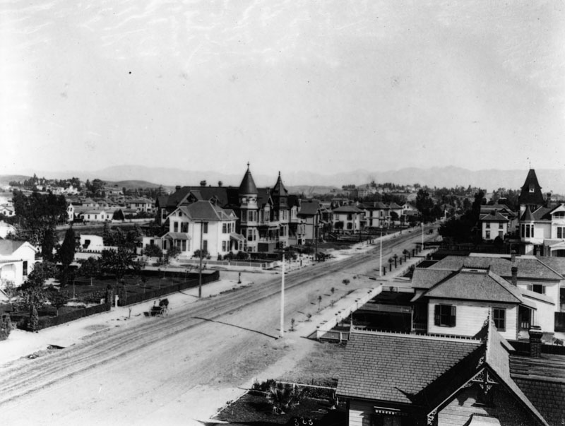
|
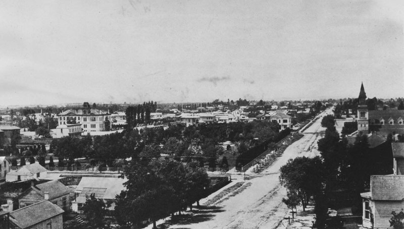
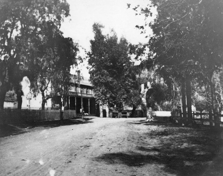
| (1880)* - New High Street (later Spring Street), north of Temple Street, with First Congregational Church and Kimball Mansion, where Helen Hunt Jackson stayed. |
Historical Notes Helen Maria Hunt Jackson (1830 – 1885) was a poet and writer who became an activist on behalf of improved treatment of Native Americans by the U.S. government. She detailed the adverse effects of government actions in her history A Century of Dishonor (1881). Her novel Ramona dramatized the federal government's mistreatment of Native Americans in Southern California and attracted considerable attention to her cause, although its popularity was based on its romantic and picturesque qualities rather than its political content. It was estimated to have been reprinted 300 times, and contributed to the growth of tourism in Southern California. |
.jpg) |
|
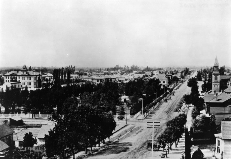
| (1880)^ - Another view of the First Congregational Church and Kimball Mansion on New High Street near Temple Street. Wagons and horses can be seen in the foreground next to a barn. |
Historical Notes The First Congregational Church building was dedicated on June 26, 1868 by the Rev. Alexander Parker and was used until 1883, when a new building was constructed at Third & Hill streets. Click HERE to see more early Views of the First Congregational Church (Oldest Continuous Protestant Church in Los Angeles). |
* * * * * |
Hill and 3rd Streets
 |
|
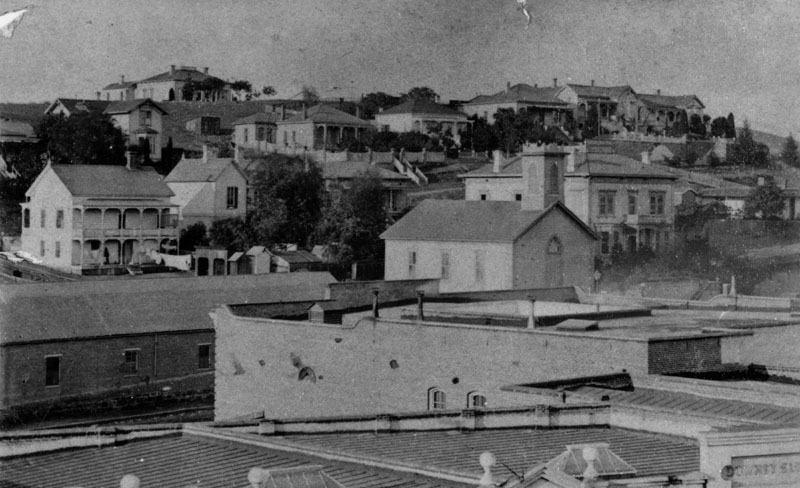
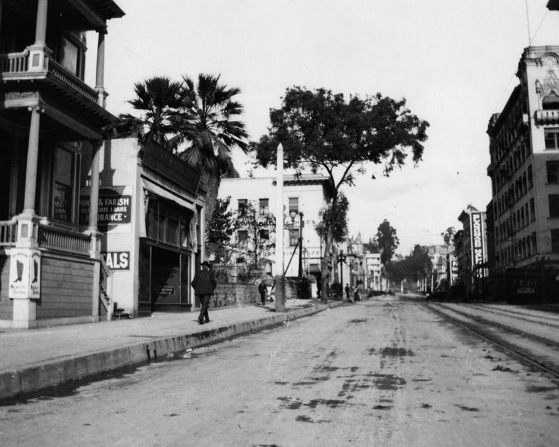
| (ca. 1880)* - View of Hill Street, looking north from 3rd. A man walks by the Mines & Farish real estate and insurance office. Palm trees at the side shade a bit of the office building. Although the street has electric railroad lines it is still unpaved |
 |
|
| (ca. 1880)^ - Hill Street looking south towards 3rd Street from Bunker Hill. In the middle of the photo is the First Congregational Church at 3rd and Hill streets. The spire to the left of the Congregational Church belongs to the German Methodist Church on 4th Street. |
Historical Notes Hill Street was originally laid out in 1849 by Edward Ord. At that time, the street's northern end was near 4th Street, the roadway being obstructed by its namesake, Bunker Hill. The northern section of the street was originally named Castelar Street, and several institutions along this end of the street still bear that name. |
* * * * * |
Hill and 2nd Streets
 |
|
| (ca. 1880)^ - Hill Street looking south from 2nd in the early 1880s. Residential buildings are interspersed with churches and vacant lots. |
Historical Notes In the middle of the photo is the First Congregational Church at 3rd and Hill. It was built in 1883. Reverend A.J. Wells, the pastor at that time, sold it to Central Baptist Church for $40,000 in 1889. Unable to pay the full amount, $30,000 was eventually settled on. It was later sold to the Unitarian Church. To the left of the Congregational Church is the German Methodist Church on 4th St. |
* * * * * |
Broadway (Fort Street) and Temple
 |
|
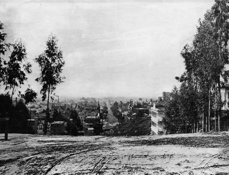
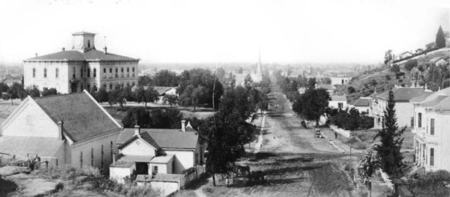
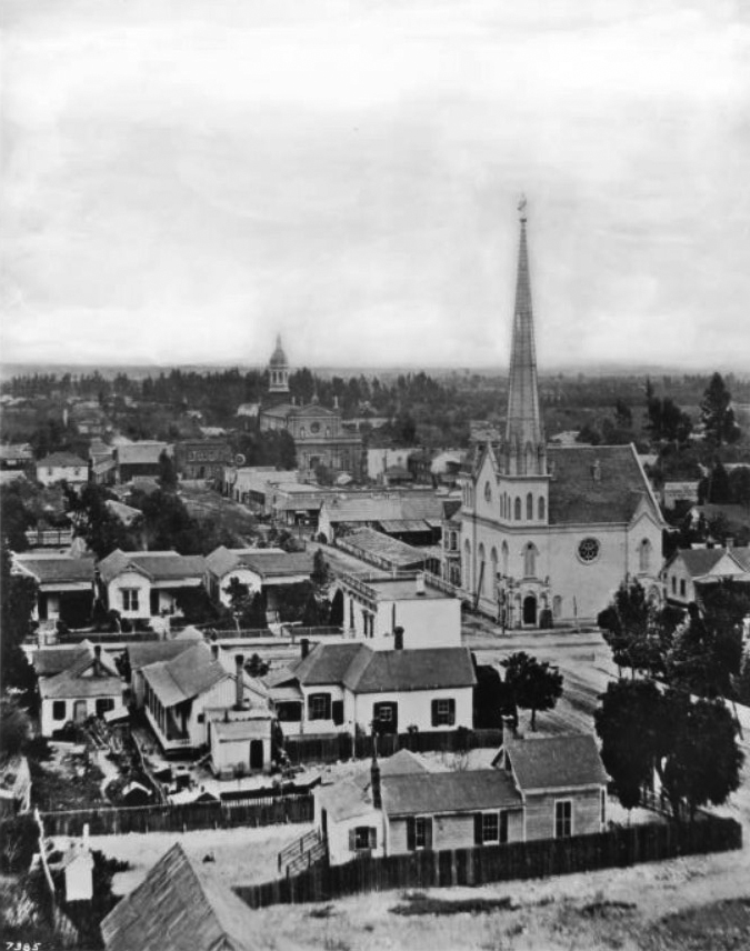
| (ca. 1881)* - Panoramic view looking south on Fort Street (later Broadway) near Temple Street. Los Angeles High School stands on Poundcake Hill, with the First Presbyterian Church visible in the distance. |
Historical Notes Construction of the school began in 1872 on the former site of Central School, the city’s first public elementary institution. When the new four-room building opened in 1873, it housed both the elementary program and the newly created Los Angeles High School. Two classrooms served Central School, and two were set aside for high school students. This shared arrangement led to later confusion about the name of the building, but the high school quickly became the dominant identity of the campus. The hilltop location on Poundcake Hill made the school one of the most prominent landmarks in early Los Angeles. The surrounding area was still lightly developed, with scattered houses, open land, and a few churches such as the First Presbyterian Church at Fort and 2nd Streets. This photograph captures a moment when Los Angeles was just beginning to expand north and west into today’s downtown. |
 |
|
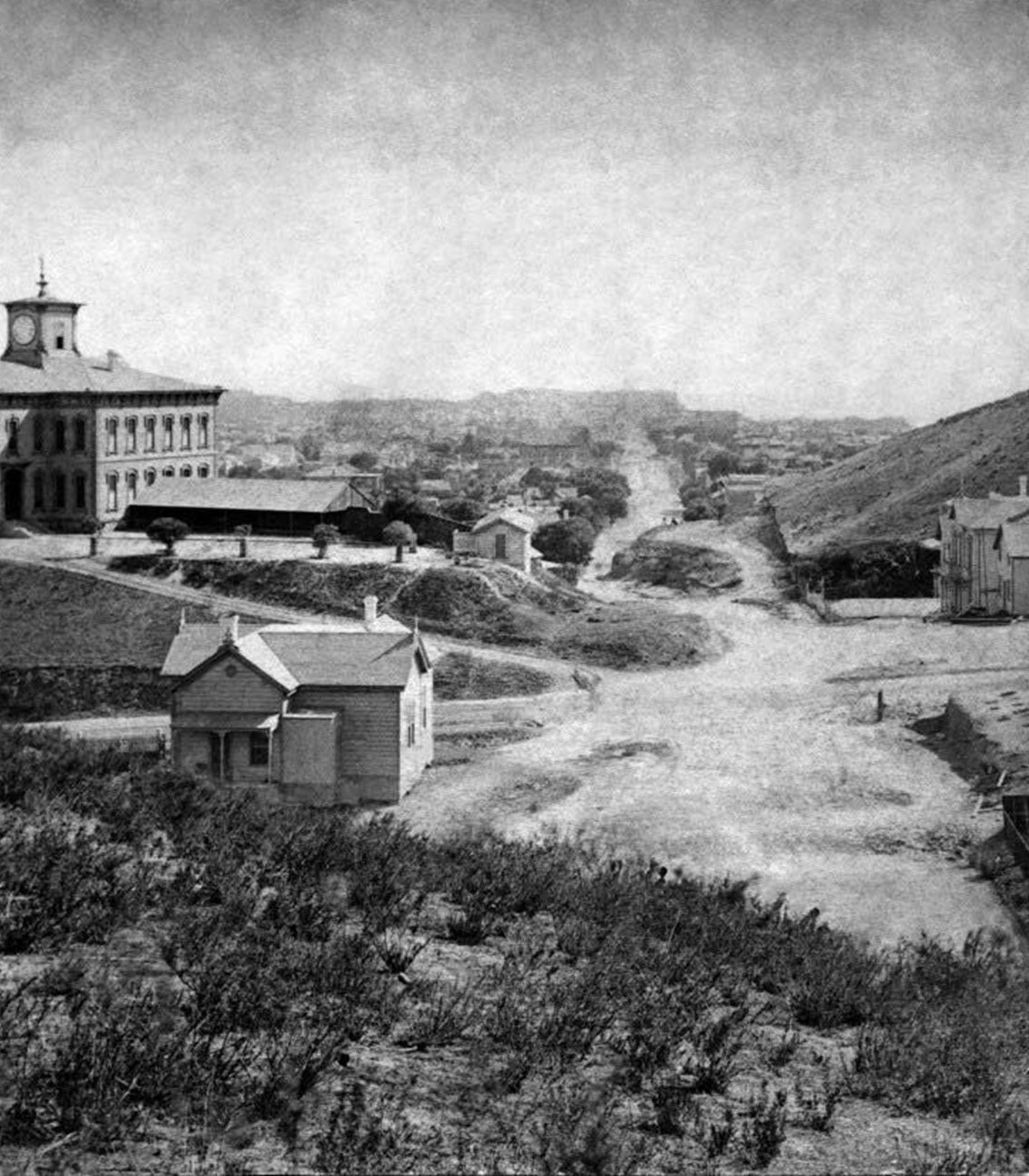
| (ca. 1875)* - Looking south on Fort Street (now Broadway) from Fort Moore Hill. Los Angeles High School stands at the crest of Poundcake Hill at Temple Street. (Henry T. Payne stereographic photograph.) |
Historical Notes When this image was taken, the new school building was only two years old. It sat at the southeast corner of Fort and Temple Streets on the site formerly occupied by Central School. Because the structure served both elementary and high school students, people often referred to it by either name. Over time, Los Angeles High School became the familiar title, especially as the city placed more emphasis on secondary education. Fort Street remained mostly rural in 1875, with few structures beyond the school building itself. Within ten years, downtown’s rapid growth led the city to choose Poundcake Hill as the site for the new county courthouse. The entire school building was then moved off the hill in 1886, ending its short but important role as the city’s first dedicated high school site. |
Before and After
 |
|
| (1875 vs. 1881)* – Looking south on Fort Street (renamed Broadway in 1890) toward Temple Street from Fort Moore Hill. The 1881 view shows the spire of the First Presbyterian Church at Fort and 2nd Streets. Photo comparison by Jack Feldman. |
Historical Notes These two views show how quickly the area changed during the late 1800s. In 1875, Los Angeles High School, originally built for both elementary and secondary grades, stood largely alone at the top of Poundcake Hill. Only a few homes and businesses occupied the surrounding blocks. By 1881, more homes, trees, and churches had begun to fill the landscape, signaling the shift from a small town to an emerging city. Fort Street would soon be renamed Broadway and developed into one of Los Angeles’s main commercial corridors. The First Presbyterian Church, visible in the later view, reflects the spread of civic and religious institutions as the population grew. |
Click HERE to see more Early Views of Los Angeles High School |
* * * * * |
 |
|
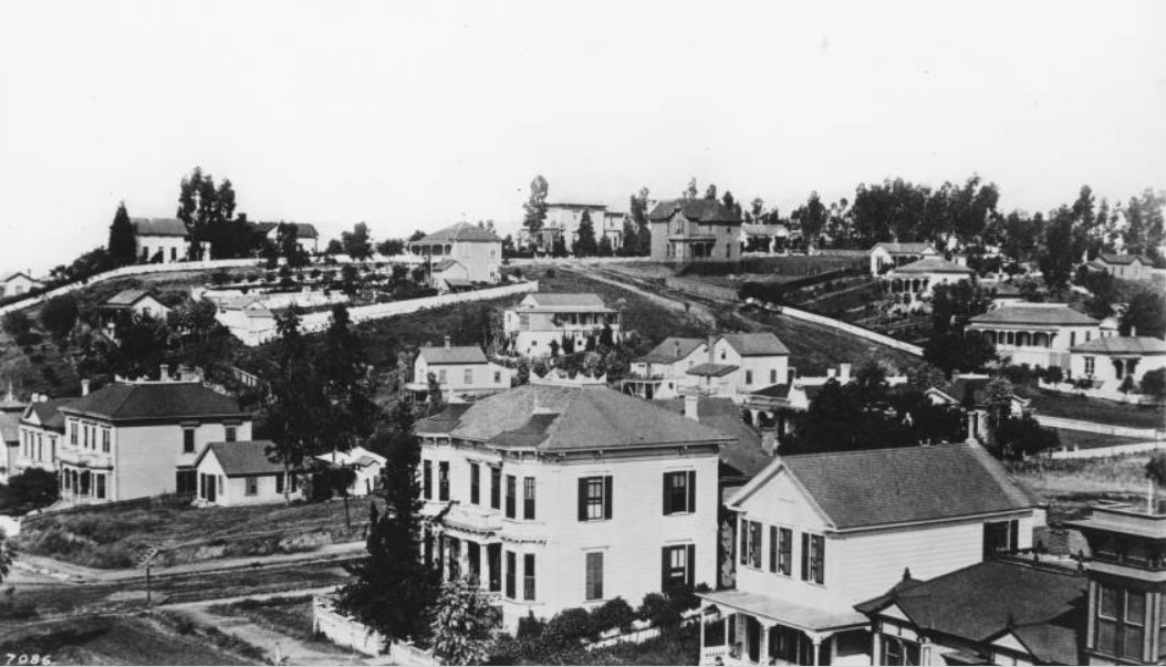
| (ca. 1880)^^ - Panoramic view looking southwest of the residential area surrounding Broadway, Temple Street and Hill Street. Two-story victorian-style houses fill the frame, situated on top of or at the foot of the hill in the background on which several of the roads converge. The houses are interspersed with trees. |
 |
|
| (1885)^ - Looking west towards Bunker Hill as it appeared in 1885. Hill Street runs through the center, with 3rd Street (not shown) to the left of the First Congregational Church (left) which later became the Central Baptist Church and then the Unitarian Church. |
 |
|
| (1880s)^ - An unpaved Olive Street, looking north from approximately 7th or 8th Street in a time when it was a residential area. Bunker Hill and the San Gabriel Mountains can be seen in the distance. Horse-drawn vehicles are also visible. |
.jpg) |
|
| (ca. 1881)^^ - Photograph of a lithograph by E.S. Glover depicting the left panel of a panoramic view of Los Angeles, looking southeast. |
.jpg) |
|
| (ca. 1881)^^ - Photograph of a lithograph by E.S. Glover depicting the right panel of a panoramic view of Los Angeles, looking southwest. |
Historical Notes A sweeping view of the city is shown above, with more hilly, rural land visible in the foreground. At the center foreground, a windmill is pictured, just to the left of a circle of trees. Farther right, the silhouettes of two purveyors can be seen atop the swell of one of the hills. Major streets such as Temple Street, Alameda Street and Main Street are labeled. An earlier record reads "Panoramic view of Los Angeles from hill back of Sisters Hospital on Sunset Boulevard”. |
* * * * * |
From La Plaza Abaja to Pershing Square
Early Views of L.A.’s Oldest Public Park
 |
|
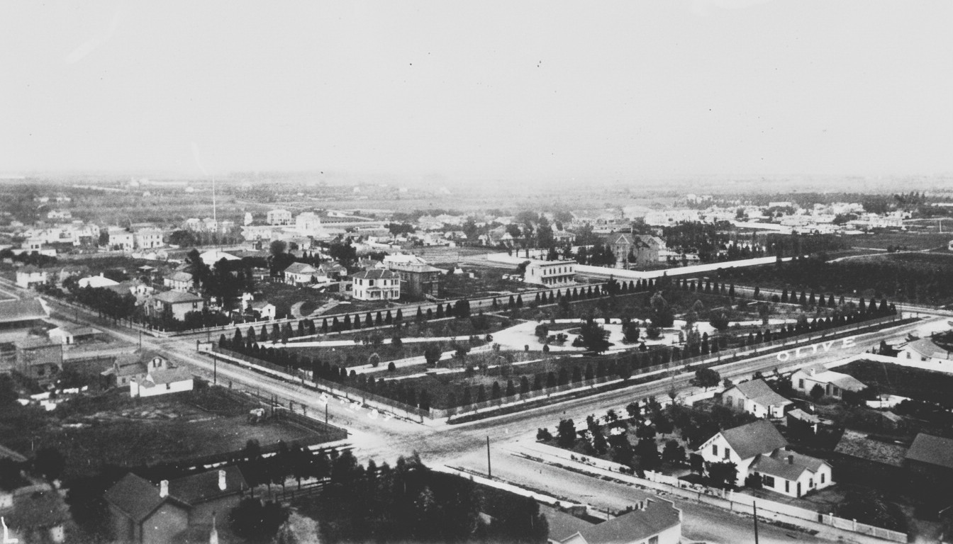
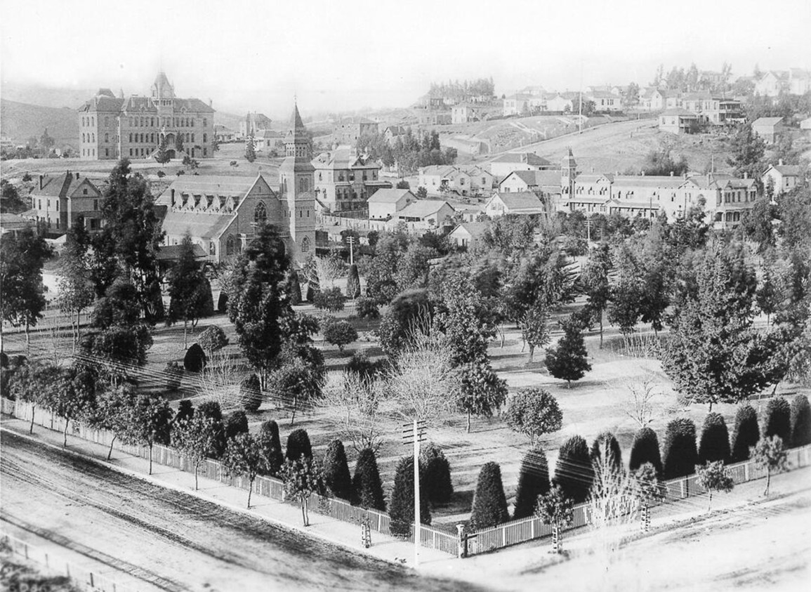
| (ca. 1880)* - Panoramic view showing Los Angeles City Park (later Pershing Square) from Fifth Street and Olive Street, downtown Los Angeles. A rectangular-shaped park can be seen at center surrounded with trees. Pathways can be seen in the park amongst grass lawns. Dirt roads line each side of the park, while one- to two-story residential buildings are visible around the park. Most of the buildings have yards and trees nearby. The flat land in the background is mostly devoid of buildings. |
Historical Notes The land that became Pershing Square was part of the original pueblo grant from Spain in 1781. In the 1850s it was still on the edge of town and was used as a camp by settlers who were living outside the older Plaza area around the church and Olvera Street. Surveyors drew it as ten separate lots, but in practice it functioned as a single five acre open space, with a small watercourse called Arroyo de los Reyes and canals from the Zanja Madre running nearby. In 1866, Mayor Cristobal Aguilar formally dedicated the block as a public square called La Plaza Abaja, or “The Lower Plaza.” A nearby beer garden owner, George “Roundhouse” Lehman, planted cypress, fruit trees, and flowering shrubs here and cared for them for many years, helping turn the dusty block into a green refuge in what was still a small, semi-rural town. |
 |
|
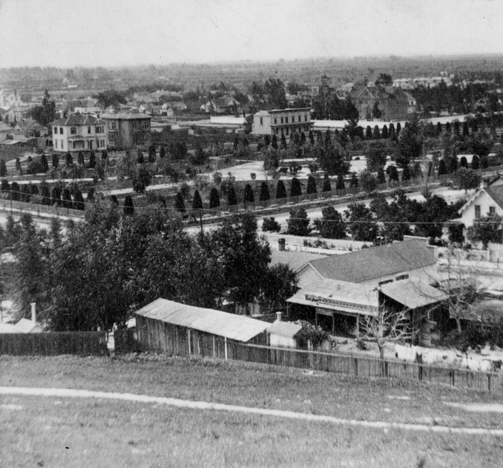
| (ca. 1880)^ - Close-up view of City Park (now Pershing Square) taken from Bunker Hill, looking southeast. |
Historical Notes By the early 1880s the former La Plaza Abaja was more commonly known as Los Angeles City Park. The paths, lawns, and young trees visible in this view show how the block had begun to function as a true town square, providing shade, open space, and a social gathering place for nearby residents. The park sat a short walk from the original business district along Main and Spring Streets, so it quickly became a favorite spot for leisurely walks and informal meetings. Its location between the older Plaza area to the northeast and the new commercial growth to the south made it a bridge between different phases of the city’s development. |
 |
|
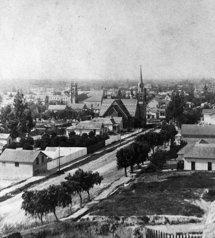
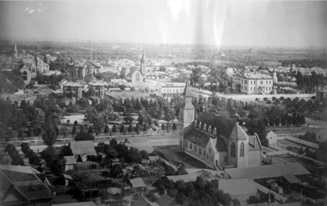
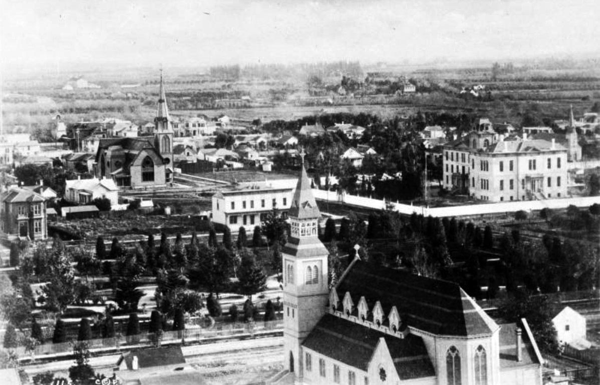
| (ca. 1883)* - View looking southeast from the State Normal School (current location of Central Library) showing St. Paul's Pro-Cathedral (lower-right) with Los Angeles Park (now Pershing Square) across the street. |
Historical Notes By 1883, the block had been officially renamed Los Angeles Park, but it was already acquiring several informal names tied to nearby institutions. The State Normal School opened in the early 1880s to train teachers for California’s growing public school system. At the same time, St. Paul’s, a new Episcopal church on Olive Street, gave the southeast corner a strong religious presence. Together, the park, the Normal School, and the nearby churches helped make this part of town a cultural and educational center. The park served not only as a place for recreation, but also as a front yard for lectures, religious events, and public ceremonies that reflected the city’s ambitions to be more than a frontier outpost. |
 |
|
| (ca. 1883)* - Closer view of Los Angeles City Park (now Pershing Square) looking southeast as seen from the State Normal School showing the newly built St. Paul's Pro-Cathedral (lower-right) at the present site of the Biltmore Hotel. The multi-story building on the right is St. Vincent's College located on Hill Street between 6th and 7th Streets. |
Historical Notes In this closer view, Los Angeles Park is framed by two important educational and religious institutions. St. Paul’s Pro-Cathedral, completed in 1883 on Olive Street, soon became a leading Episcopal church and later the pro-cathedral for the diocese. Across the way, St. Vincent’s College, founded by the Vincentian Fathers in the 1860s, was the first college in Southern California. Because of St. Vincent’s presence, the park was often called St. Vincent’s Park in everyday speech. The mix of a college, a major church, and a central green space gave this block an importance out of proportion to its size. It became a place where students, clergy, professionals, and families all crossed paths, reflecting the growing social diversity of downtown Los Angeles. |
 |
|
| (ca. 1880s)^ -View looking south on Olive from between 4th and 5th Streets, with St. Paul’s Pro-Cathedral, St. Vincent’s College, and Central Park. |
Historical Notes By the mid 1880s, this stretch of Olive Street had become one of the city’s best known cultural corridors. St. Paul’s Pro-Cathedral on the right offered regular services, special events, and diocesan functions. On the left, the older St. Vincent’s College building still stood, later serving as temporary quarters for the YMCA. Between them lay the evolving city park, which would soon be renamed Central Park. The unpaved street, horse drawn vehicles, and modest two and three story buildings show how early the city still was in its development. Yet the presence of churches, schools, and a central green square pointed toward the more dense and urban downtown that would emerge in the next few decades. |
 |
|
| (ca. 1885)^ - Panoramic view of 5th and Olive Streets, looking south in the early 1880s. Central Park (later Pershing Square) is seen with St. Paul’s Pro-Cathedral and St. Vincent’s College. Same view as previous photo but a couple of years later (note the addition of telephone poles along Olive Street). |
Historical Notes In this view, Central Park is beginning to take on the character that made it one of the city’s favorite gathering places in the late nineteenth century. Frederick Eaton, who later became mayor, created one of the first formal landscape plans for the park in the 1880s. The result was a more structured layout with paths, plantings, and shaded areas that invited longer visits and regular use. The dirt streets and horse drawn traffic still recall an older, slower Los Angeles, but telephone poles are now visible along Olive Street, hinting at new technologies and a city increasingly tied into regional and national networks. The combination of a refined park, nearby schools and churches, and emerging infrastructure made this corner an early symbol of the city’s modernization. |
 |
|
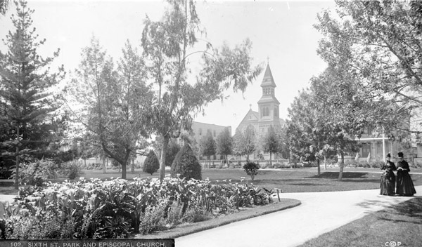
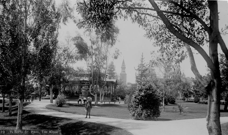
| (ca. 1888)^^ - View of two women walking along a walkway in Sixth Street Park (formerly St. Vincent’s Park). Today, this is the site of Pershing Square. |
Historical Notes By the late 1880s the park had been renamed Sixth Street Park, reflecting its location between 5th and 6th Streets. The lawns, flower beds, and well kept paths made it a popular place for quiet walks, especially for residents who lived in the surrounding houses and boarding hotels. Women, children, and older residents often used the park during the day, while bands, public speakers, and social groups sometimes gathered there in the evenings. This scene of two women strolling along a path gives a sense of how the park functioned as a safe public space in the heart of a growing downtown, long before the arrival of skyscrapers, cars, and concrete paving. |
 |
|
| (ca. 1890)^^ - View of Pershing Square, then called Sixth Street Park. Later it would be called Central Park and then Pershing Square (post World War I). |
Historical Notes Around 1890, the park was still officially called Sixth Street Park, but it was already on its way to being known as Central Park. New landscaping during this period added more lush, almost subtropical plantings, and a bandstand pavilion was introduced to host concerts, speeches, and civic events. As Los Angeles expanded, the park became a kind of outdoor living room for downtown, a place where people could hear music, meet friends, listen to orators, or simply escape the dust and heat of nearby streets. This role as a public stage would continue well into the twentieth century, even after the park’s name was officially changed to Pershing Square in 1918 in honor of General John J. Pershing. The following is a chronology of name changes the park has seen before becoming Pershing Square: ◆ 1866 – La Plaza Abaja or "The Lower Plaza" ◆ 1867 – St. Vincent Park ◆ 1870 – Los Angeles Park ◆ 1886 – 6th Street Park ◆ 1890s- Central Park ◆ 1918 – Pershing Square |
 |
|
| (ca. 1885)* - View of Sixth Street Park, looking northwest from 6th Street and Hill Street toward St. Paul's Pro-Cathedral on Olive Street. The State Normal School can be seen on a hill in the distance, located on the southwest corner of Grand and 5th Street. The slopes of Bunker Hill are on the right. |
Historical Notes This photograph captures Sixth Street Park at a moment when the surrounding district was becoming one of the city’s main educational and cultural hubs. The State Normal School at 5th and Grand trained teachers for public schools across Southern California, while St. Paul’s Pro-Cathedral hosted diocesan functions and large religious gatherings. The park itself offered open space for students, churchgoers, and nearby residents. The rough slopes of Bunker Hill in the background had not yet been fully built up, but would soon be lined with the Victorian houses and apartment buildings that later became famous in photographs of old Los Angeles. |
 |
|
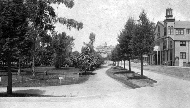
| (ca. 1890)* – Looking west on 5th Street at Hill Street. On the left is 6th Street Park (now Pershing Square). In the distance is the State Normal School. On the right is Hazard’s Pavilion. |
Historical Notes By about 1890, this corner brought together three important pieces of the city’s life: Sixth Street Park for recreation, the State Normal School for education, and Hazard’s Pavilion for entertainment and public events. Hazard’s Pavilion, built in 1887 at 5th and Olive, could seat several thousand people and hosted everything from opera and concerts to political rallies, boxing matches, and religious revival meetings. The State Normal School, opened a few years earlier, later evolved into part of the University of California system and is considered an early ancestor of UCLA. The presence of these institutions around the park anchored this part of downtown as a center for culture, learning, and civic activity long before the rise of high rise office towers and the Central Library. |
 |
|
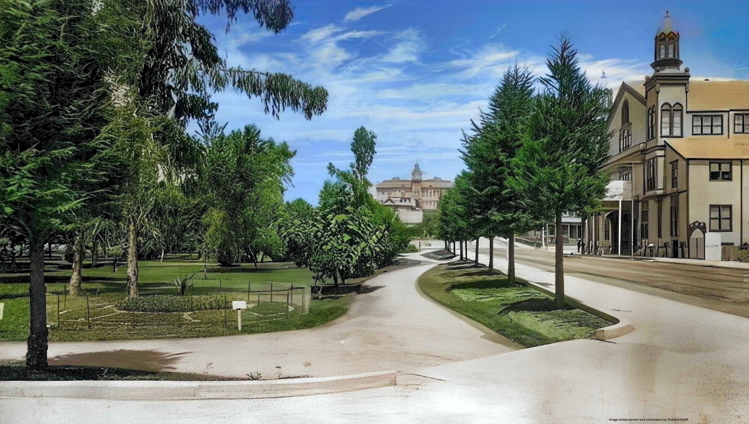
| (ca. 1890)^ – View looking west on 5th Street from Hill Street showing Hazard’s Pavilion at the northeast corner of 5th and Olive, 6th Street Park on the left, and the State Normal School in the distance. Image enhancement and colorization by Richard Holoff. |
Historical Notes This view shows how closely tied the park and surrounding institutions were to everyday life in late nineteenth century Los Angeles. Residents could attend a lecture, concert, or rally at Hazard’s Pavilion, stroll through the shaded paths of Sixth Street Park, and look up at the imposing mass of the State Normal School on the hill at Grand Avenue. Within a few decades the scene would change dramatically. Hazard’s Pavilion was demolished in 1905 to make way for the Philharmonic Auditorium, and in the 1920s the Normal School was torn down so that 5th Street could be extended and the new Central Library could be built on the site. This photograph preserves an earlier phase when the park, pavilion, and school defined the western edge of the downtown core. |
Then and Now
 |
|
| (1890 vs. 2021)* – Looking west on 5th Street at Hill Street. In the early image, Sixth Street Park (now Pershing Square) is on the left and the State Normal School rises on the hill at Grand Avenue, where 5th Street originally dead-ended. On the right is Hazard’s Pavilion, built in 1887 and later replaced by the Philharmonic Auditorium. After the State Normal School was demolished in 1924, 5th Street was extended and the L.A. Central Library was constructed on the old school site. Photo comparison by Jack Feldman. |
Historical Notes In the late 1800s, Sixth Street Park was one of the earliest green spaces in downtown Los Angeles. With its lawns, paths, and shaded seating areas, the park served nearby residents, churchgoers, and students from St. Vincent’s College. Over a few decades it carried several names—Los Angeles Park, St. Vincent’s Park, Sixth Street Park, and finally Pershing Square in 1918—reflecting the city’s rapid growth and changing identity. To the right in the early view stood Hazard’s Pavilion, a 4,000-seat hall that hosted concerts, political rallies, expositions, and religious events. It was one of the largest indoor gathering spaces in Southern California until its demolition in 1905 to make way for the Philharmonic Auditorium. The State Normal School, visible on the hill at Grand Avenue, trained teachers for Southern California’s expanding public school system. The school was removed in the 1920s so that 5th Street could be extended and the new Los Angeles Central Library could be built on the site. The modern scene shows how dramatically this corner of downtown transformed in the 20th century. The Biltmore Hotel, completed in 1923, anchors the western side of Pershing Square, and the skyline has risen around the park. Despite redesigns, demolitions, and changing surroundings, Pershing Square remains the city’s oldest dedicated public square and continues to occupy the same 5-acre block set aside in 1866. |
 |
|
| (ca. 1900)^ - View of the central city looking northwest over Pershing Square toward Bunker Hill and the Hollywood Hills |
Historical Notes Around 1900, the park was generally known as Central Park and had become a lush, shaded oasis surrounded by hotels, boarding houses, churches, and small office buildings. In the foreground, St. Paul’s Episcopal Church and nearby residences show how closely religious and residential life bordered the park. Beyond the square, Bunker Hill rises with its growing collection of Victorian houses and flats, while the low Hollywood Hills are visible in the far distance. This view illustrates how Central Park functioned as a visual and social center of the city. It tied together downtown’s commercial streets, the dense residential district on Bunker Hill, and the broader landscape that stretched toward the Cahuenga Pass and the Hollywood area that would later become famous. |
 |
|
| (ca. 1913)* - View looking southeast showing St. Paul’s Episcopal Church in the foreground, Pershing Square, and part of the city skyline. |
Historical Notes By 1913, the park had gone through several name changes and redesigns and was now often referred to as Central Park. The surrounding skyline had begun to rise with taller commercial buildings, signaling downtown’s rapid growth in the early twentieth century. St. Paul’s still stood facing the park, but within a decade its Olive Street site would be sold and the church replaced by the Biltmore Hotel. In 1918, shortly after the end of World War I, the city officially renamed the park Pershing Square in honor of General John J. Pershing. This change reflected Los Angeles’ desire to associate its central public space with national pride and modern civic identity, even as many of the park’s nineteenth century surroundings were being replaced by larger hotels, office buildings, and later, underground parking and redesigns. |
Before and After
 |
|
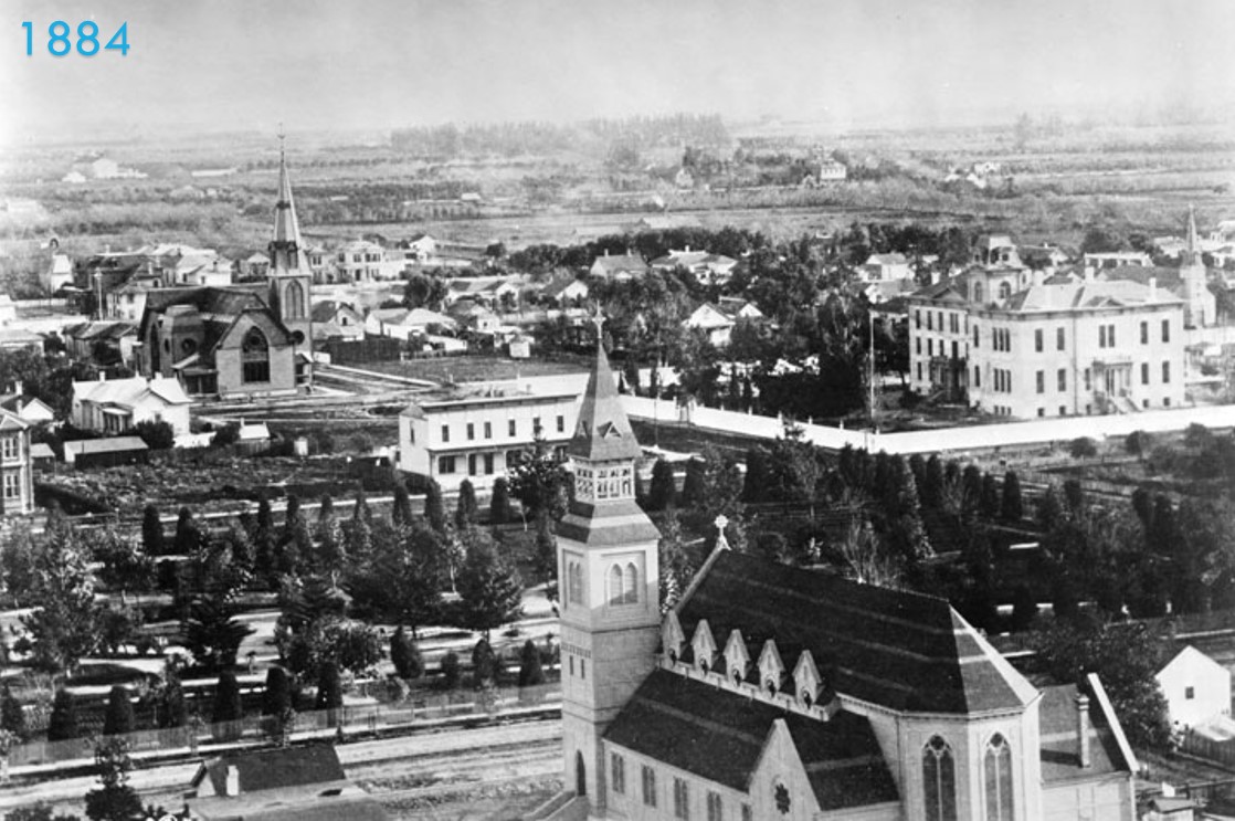
.jpg) |
Historical Notes The 1884 view shows the park in one of its earliest landscaped forms, bordered by two of the most important cultural institutions of the era. St. Paul’s Pro Cathedral stood on the east side of the park until the early 1920s, while the State Normal School on the hill at Grand Avenue trained teachers for the fast growing public school system. At this time the park was still known simply as Los Angeles Park. By 1913, the block was officially called Central Park and had been redesigned with new walkways, planting schemes, and public gathering areas. The skyline around it had changed significantly, with early multi story commercial buildings rising along Hill, Broadway, and 6th Street. These new structures signaled downtown’s rapid transformation from a low rise town to a modern business center. Within a few years after the 1913 view, the landscape would change even more. St. Paul’s would be demolished to make way for the Biltmore Hotel, the State Normal School would be removed so that 5th Street could be extended, and in 1918 the park would receive its permanent name: Pershing Square, honoring General John J. Pershing at the end of World War I. |
Click HERE to see more Early Views of Pershing Square |
* * * * * |
Spring and 6th Street
 |
|
| (ca. 1882)* - A view of 6th St. looking west with Spring St. crossing in the foreground. The Spring Street School is in the right foreground. This would later be the site of the Arcade Building. |
Main Street
 |
|
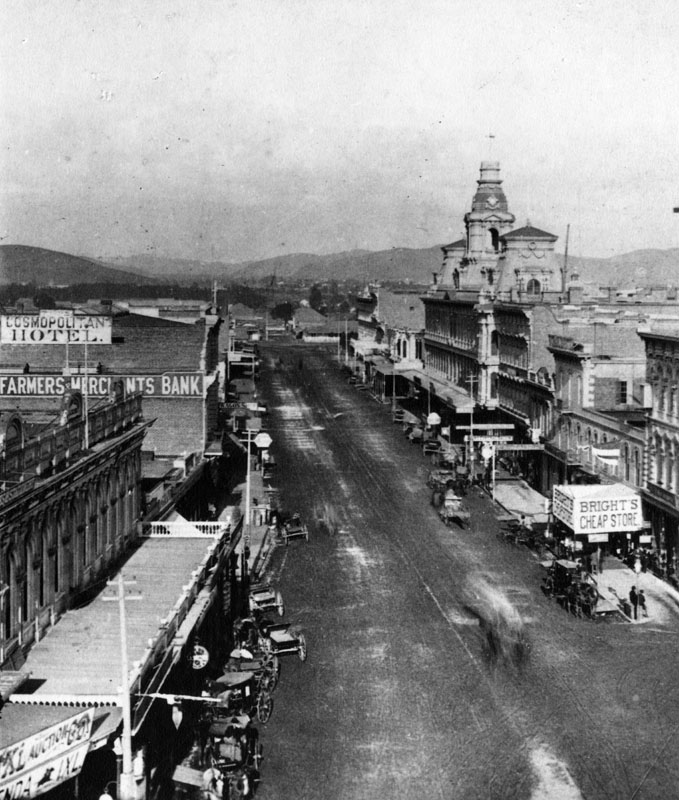
| (1882)^ - View looing north on Main Street, with the Downey Block on the left, followed by the second location of the Farmers and Merchants Bank from June 15, 1874, to October 29, 1883, followed by the Cosmopolitan Hotel (previously Lafayette Hotel). On the right is the Ducommun Building, Bella Union-Clarendon-St. Charles Hotel, Pico Building (the first home of Farmer's and Merchants Bank), the Grand Central Hotel, and the Baker Block (with towers). |
 |
|
| (1882)^ - View looking north on Main Street with buildings annotated. The Farmers and Merchants Bank opened October 29, 1882 in the Hellman Building. First National Bank, formerly Commercial Bank, was in the building on the right. The Duccommon building can be seen at center-left of photo. |
 |
|
| (ca. 1882)**- One of the first of seven electric street lights installed in the City of Los Angeles at Main Street and Commercial Street in 1882. It stood 150 feet tall. Baker Block is on the left and the Ducommun Building on the right. |
Historical Notes Each of the 150-foot-high masts carried three carbon-arc lamps of three thousand candle-power. All seven lamps and a small power plant to provide the electricity were installed by C. L. Howland in 1882. In 1883, Howland and others formed the Los Angeles Electric Company.** Click HERE to see more in Early Los Angeles Street Lights. |
 |
|
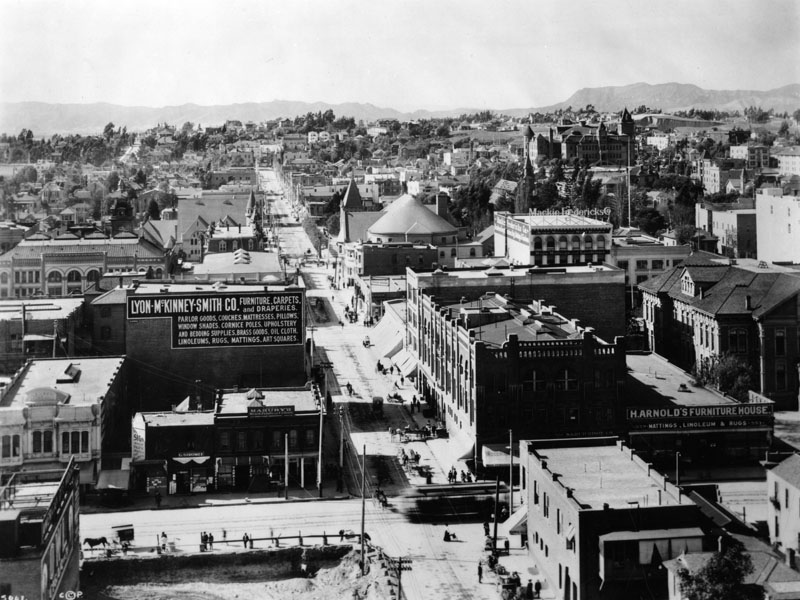
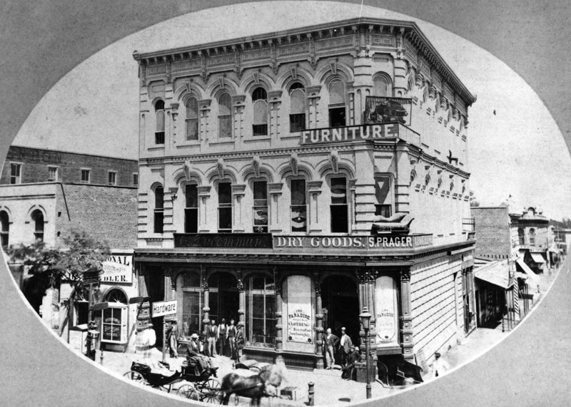
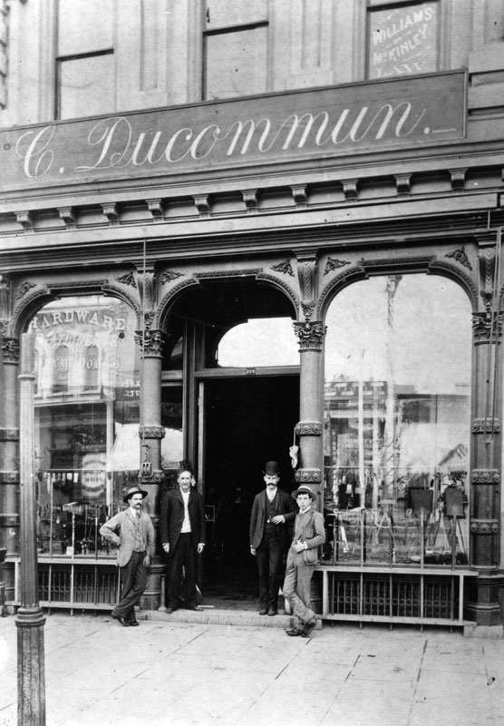
| (ca. 1882)^ - Hardware Store of C. Ducommun, dry goods store of S. Prager and a furniture store at 204 N. Main Street (after 1890 at 304 N. Main Street) are shown. |
Historical Notes Charles Louis Ducommun, a watchmaker by training, emigrated to the US from Switzerland in the early 1840s. He started a general store, providing supplies (and credit) to gold prospectors and other pioneers who had settled in the burgeoning pueblo of Los Angeles. Ducommun Street was named for Charles Louis.^* |
 |
|
| (1886)^ - Facade of the hardware store of C. Ducommun at 204 N. Main Street (after 1890 at 304 N. Main Street). |
 |
|
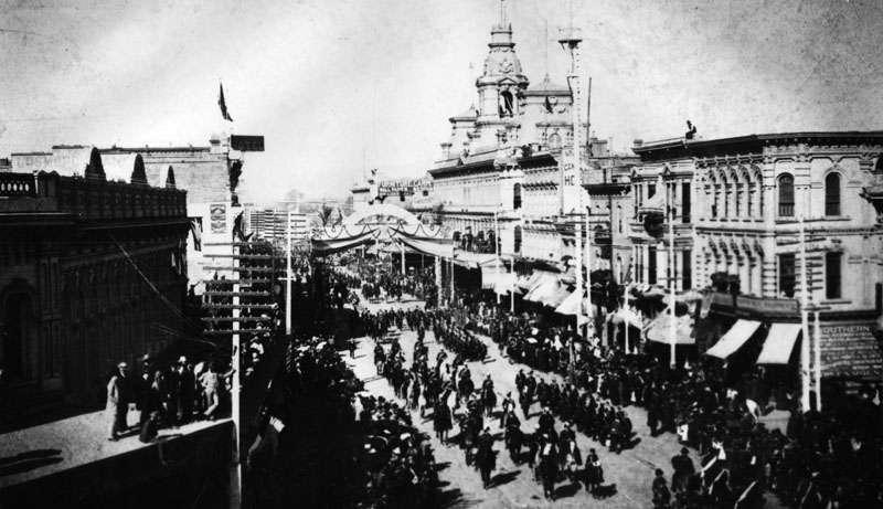
| (1882)^ - View of a parade on Main Street, looking north. Later on the right corner would be the Civic Center Plaza, at the left City Hall. |
Click HERE to see more Early Views of the Historic 300 Block of N. Main Street |
* * * * * |
Cahuenga Pass
 |
|
| (1882)^ - Before roads and rail lines were built traveling through the Cahuenga Pass was by wagons and horses or on foot. This picture was taken at the summit. There is a saloon concealed among the trees. |
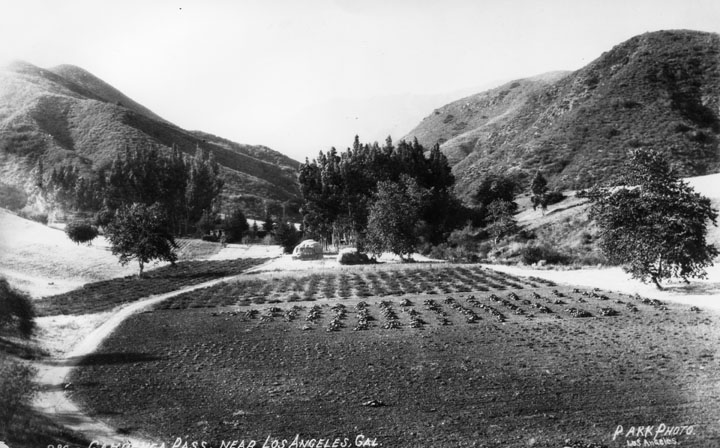
Historical Notes The Cahuenga Pass connects the Los Angeles Basin to the San Fernando Valley and is the lowest pass through the mountains. It was the site of two major battles, the Battle of Cahuenga Pass in 1831 (a fight between local settlers and the Mexican-appointed governor and his men, two deaths), and the Battle of Providencia or Second Battle of Cahuenga Pass in 1845 (between locals over whether to secede from Mexico. One horse and one mule killed) both on the San Fernando Valley side near present-day Studio City, and cannonballs are still occasionally found during excavations in the area. Along the route of the historic El Camino Real, the historic significance of the pass is also marked by a marker along Cahuenga Blvd. which names the area as Paseo de Cahuenga.^ Click HERE to see more in Early Views of the San Fernando Valley. |
 |
|
| (1882)^ - View of the summit of Cahuenga Pass with a saloon, Cahuenga Tavern, situated between the tall eucalyptus trees. |
Historical Notes Cahuenga is the Spanish name for the Tongva village of Kawengna, meaning place of the mountain.*^ |
 |
|
| (n.d.)^ - View of Cahuenga Tavern, also known as Eight Mile House, situated between eucalyptus near the summit of Cahuenga Pass. |
Historical Notes In the 1870s, a primitive hotel -- named the Eight Mile House because Los Angeles was eight miles down the road -- rose among a stand of eucalyptus trees inside the canyon. |
 |
|
| (n.d.)^ - View of early Cahuenga Pass. The road runs around and through a cultivated area. |
Historical Notes As late as 1914, filmmaker Cecil B. DeMille rented a wooden cabin in the pass as his home. He rode daily into his studio on horseback -- with a revolver on his hip. Click HERE to see more Early Views of Cahuenga Pass. |
* * * * * |
Broadway and 2nd Street
 |
|
| (ca. 1878)* - View looking east showing the intersection of Second Street and Fort Street (later Broadway) where the First Presbyterian Church, with its impressively tall spire, can be clearly seen on the southeast corner. In the distance, on the east side of Main Street just south of Second Street, stands St. Vibiana's Cathedral. |
Historical Notes This early view captures the quiet intersection of Second and Fort Street (renamed Broadway in 1890), a crossroads still in its formative stage. Dominating the southeast corner is the First Presbyterian Church, with its remarkably tall Gothic spire—a prominent Los Angeles landmark of the era. In the background, just beyond Main Street, the twin towers of St. Vibiana's Cathedral rise—then still a relatively new addition, completed in 1876. At this time, Fort Street was little more than a dirt road winding through a semi-rural downtown. Los Angeles had yet to embrace the architectural and transportation transformations that would define the next two decades. |
.jpg) |
|
| (ca. 1880)* – Street view looking at the southeast corner of Second Street and Fort Street (later Broadway). A horse-drawn coach stands parked in the street to the right of the Gothic-style First Presbyterian Church and its impressively tall spire. A man stands in the unpaved street farther to the right. A wrought-iron fence enclosed a garden of topiary across the street to the left. The city's first Jewish Synagogue, B'nai B'rith Temple, can be seen behind the church to the right. To the right of the synagogue is the future home of LA's 3rd City Hall (1888-1928). |
Historical Notes This view looks toward the southeast corner of Second and Fort Street (Broadway) around 1880. The First Presbyterian Church, built in 1873 in the Gothic Revival style, towers over the scene with its landmark spire. A lone coach stands along the dusty street while a man poses off to the right. Just behind the church rises the B’nai B’rith Temple, Los Angeles’s first synagogue, completed in 1872—reflecting the city’s early religious and cultural diversity. Also visible is the future site of L.A.’s third City Hall (1888–1928), offering a fascinating glimpse of the neighborhood just before the arrival of civic expansion and cable car tracks. |
 |
|
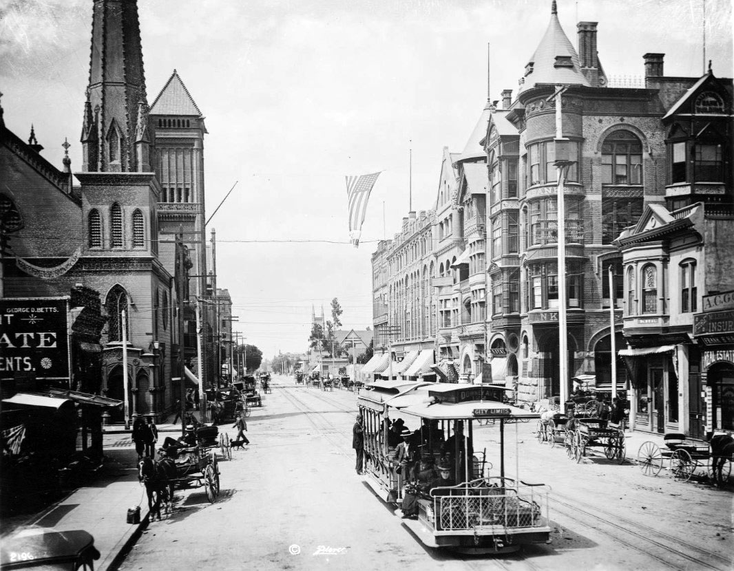
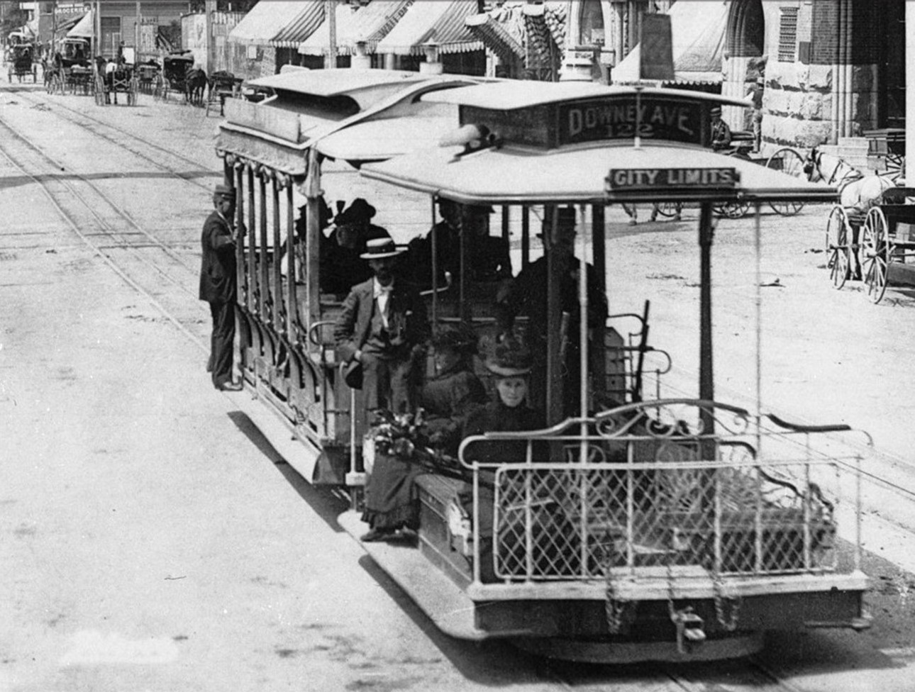
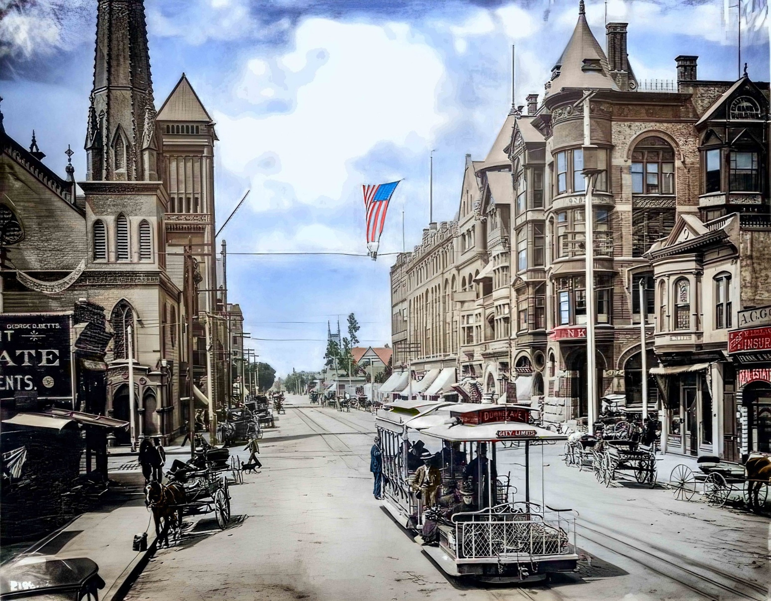
| (ca. 1894)* – View looking south toward the intersection of Broadway and 2nd Street showing a cable car full of passengers in the foreground. Horse-drawn vehicles are parked along the curb on both sides of the street. On the southeast corner (left) stands the First Presbyterian Church, with the 1888-built City Hall visible farther down at 226 S. Broadway. On the southwest corner (right) is the California Bank Building. In the distance, the newly completed Bradbury Building stands at the southeast corner of Broadway and 3rd Street. |
Historical Notes Although long attributed to 1889, the presence of the Bradbury Building—completed in 1893—confirms this photo was taken closer to 1894. The scene captures the transitional years of downtown Los Angeles, when cable cars shared the road with horse-drawn carriages and commercial buildings were rising along Broadway, formerly Fort Street (renamed in 1890). The photo also showcases early civic architecture: the spired First Presbyterian Church, the turreted California Bank Building, and the recently completed City Hall, which served until 1928. This particular cable car operated on the Downey Avenue line of the Los Angeles Cable Railway, which began service in 1889 and connected areas from 9th Street to what is now Lincoln Heights. Three main cable car companies operated in Los Angeles between 1885 and 1902: a) Second Street Cable Railroad (1885-1889): It ran along Second Street, up Bunker Hill, to Second and Texas (now Belmont) Street. b) Temple Street Cable Railway (1886-1902): This line extended 8,725 feet between Spring Street and Belmont Avenue. c) Los Angeles Cable Railway (1889-1902): The most ambitious system, it operated about 25 miles of routes, connecting downtown Los Angeles to areas now known as Lincoln Heights, Echo Park/Filipinotown, and the Pico-Union district. The cable car seen in the above image belonged to the Los Angeles cable Railway. The Downey Avenue line, now known as North Broadway, was a key route that connected various parts of Los Angeles. It extended from Ninth and Grand View, through Ninth, Figueroa, Sixth, Hill, Fourth, Broadway, First, Spring, Marchessault, Main, San Fernando, Olympia, Downey (N. Broadway), Chestnut (now Avenue 20), Pasadena, Daily, to Avenue 33. |
 |
|
| (ca. 1894)* – Close-up view of previous photo showing a cable car heading north on Broadway at 2nd Street. |
Historical Notes Cable cars soon became obsolete after engineers perfected an newer streetcar technology: the electric railway. Whereas cable railways constantly ran their engines at full power—regardless of how many cars were active on the line—to pull the heavy steel cables, the newer railways delivered electricity directly to motors located on the streetcars themselves. Cables lasted only a few years before needing replacement and were costly to bury; overhead catenary wires were inexpensive by comparison. By 1896, much of the city's cable car trackage had been converted to electricity and incorporated into a growing electric railway network. In 1902, a mere 16 years after the city hailed its first cable railway as a technological wonder, the last of L.A.'s cable cars rolled down Temple Street and into obscurity. |
 |
|
| (ca. 1894)* – View looking south toward the intersection of Broadway and 2nd Street showing a cable car full of passengers in the foreground. Horse-drawn vehicles are parked along the curb on both sides of the street. On the SE corner (left) stands the First Presbyterian Church with the 1888-built City Hall situated further south at 226 S. Broadway. To the right, on the SW corner, is the California Bank Building. In the distance can be seen Fort Street Methodist Episcopal Church, located on the west side of Broadway between 3rd and 4th streets. Note: Broadway was known as 'Fort Street' until 1890. Photo by Charles C. Pierce; Image enhancement and colorization by Richard Holoff. |
Historical Notes Although long attributed to 1889, the presence of the Bradbury Building—completed in 1893—confirms this photo was taken closer to 1894. The scene captures the transitional years of downtown Los Angeles, when cable cars shared the road with horse-drawn carriages and commercial buildings were rising along Broadway, formerly Fort Street (renamed in 1890). Color breathes new life into this classic 1894 C.C. Pierce photograph, masterfully enhanced by Richard Holoff. Broadway, still in its first year under that name, is alive with movement: a cable car packed with passengers, horse-drawn carriages lining both sides, and the spire of the First Presbyterian Church reaching skyward. To the right, the distinctive turret of the California Bank Building rises, while farther down, the 1888 City Hall anchors the civic core of a rapidly modernizing Los Angeles. The Fort Street Methodist Episcopal Church can be seen in the distance. Together, these elements capture the energetic yet transitional character of the late 19th-century city. |
 |
|
| (2022)* - Contemporary view looking south down Broadway from 2nd Street—the same vantage point once filled with cable cars, horse-drawn carriages, and church spires. Today, it’s framed by office towers, concrete, and traffic signals—but the footprint of the past still shapes the streetscape. |
Historical Notes This present-day view of Broadway at 2nd Street shows a dramatically transformed cityscape. Gone are the cable cars, gas lamps, and spired churches that once defined the area. In their place stand commercial high-rises, traffic lights, and the infrastructure of a modern metropolis. Yet the street grid remains intact, echoing decisions made in the 19th century. Broadway continues to serve as a key artery in downtown Los Angeles, still tracing the path laid out when the street was known as Fort Street prior to 1890. |
Then and Now
 |
|
| (1894 vs 2022)* - A 'Then and Now' view looking south on Broadway at 2nd Street. Photo comparison by Jack Feldman. |
Historical Notes This 'Then and Now' photo comparison bridges nearly a 130 years of change at the intersection of Broadway and 2nd Street. In the 1894 image, Los Angeles is caught in the act of becoming—a city where cable cars share the street with carriages and pedestrians, where Gothic and Romanesque facades dominate the skyline, and where civic ambition is embodied by the newly completed City Hall. In the 2022 image, little remains of that early world. The First Presbyterian Church, B’nai B’rith Temple, and the California Bank Building have vanished, replaced by the geometry of modern development. Still, the orientation of the street, the flow of traffic, and even the sunlit perspective remind us that history is never truly erased—only built upon. |
Then and Now
.jpg) |
|
| (1894 vs 2022)* - Looking south on Broadway at 2nd Street. Photo comparison by Jack Feldman. |
Historical Notes This “Then and Now” juxtaposition bridges more than 130 years of change at the intersection of Broadway and 2nd Street. The 1894 image reveals a city on the rise—marked by ornate spires, the hum of cable cars, and architectural ambition. In the modern 2022 view, only the street grid remains recognizable; all else has been transformed. Missing are the churches, the cable lines, the horses—and in their place, high-rises, traffic lights, and a vertical downtown skyline. The spire of First Presbyterian and the arc of the cable car tracks have long vanished, but this image reminds us how the past remains embedded beneath our feet. Click HERE to see more Early Views of the intersection of Broadway and 2nd Street in the 1880s. |
* * * * * |
Main and 3rd Streets
 |
|
| (1880s)^ - View looking north on Main Street near 3rd Street showing a large Cactus tree in front of the "Round House", with a kindergarten sign seen on the left. In the distance, on the right, can be seen St. Vibiana's Cathedral. |
Historical Notes The Round House was once a popular beer garden and later became LA's first kindergarten |
 |
|
| (ca. 1884)^ - Main Street near 3rd, looking north. Workers are laying double tracks down for the horse-drawn street car line. St. Vibiana's Cathedral is seen in the distance. |
* * * * * |
Main and 2nd Streets
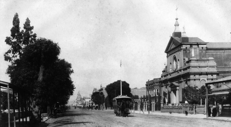 |
|
| (1884)^ - Main Street looking north toward 2nd Street, showing the Cathedral of St. Vibiana on the right side. Horse-drawn streetcar can be seen heading South on Main Street. |
Historical Notes The Cathedral of Saint Vibiana, often called St. Vibiana's, opened in 1876 as the cathedral for what was then known as the Diocese of Monterey-Los Angeles, and remained the official cathedral of the Los Angeles for over 100 years.*^ |
 |
|
| (ca. 1887)+# – View looking north on Main Street toward 2nd Street showing numerous horse-drawn wagons and including a horse-drawn streetcar in front of St. Vibiana's Cathedral. |
Historical Notes Electric-powered streetcars did not begin operating until 1887.*##^ |
 |
|
| (1885)^^ - Exterior view of St. Vibiana's Cathedral located at 200-248 S. Main Street. A man stands near a horse-drawn carriage that is parked on the dirt road in front of the church. |
Historical Notes In 1963, St. Vibiana's Cathedral was dedicated as Los Angeles Historic Cultural Monument No. 17 (Click HERE to see complete listing). Click HERE to see more Early Views of St. Vibiana's Cathedral. |
Then and Now
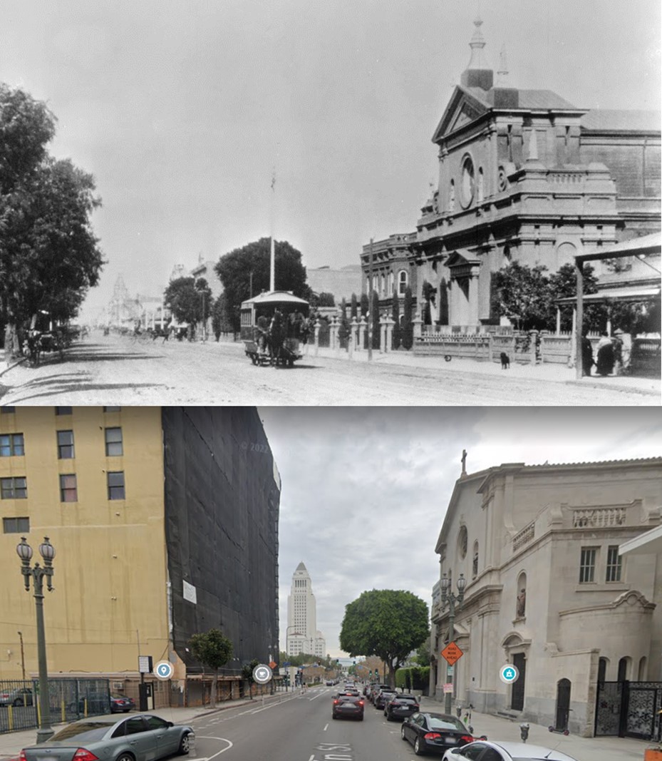 |
|
| (1884 vs. 2021)* – Looking north on Main Street toward 2nd Street showing the Cathedral of St. Vibiana building on the right. Photo comparison by Jack Feldman. |
* * * * * |
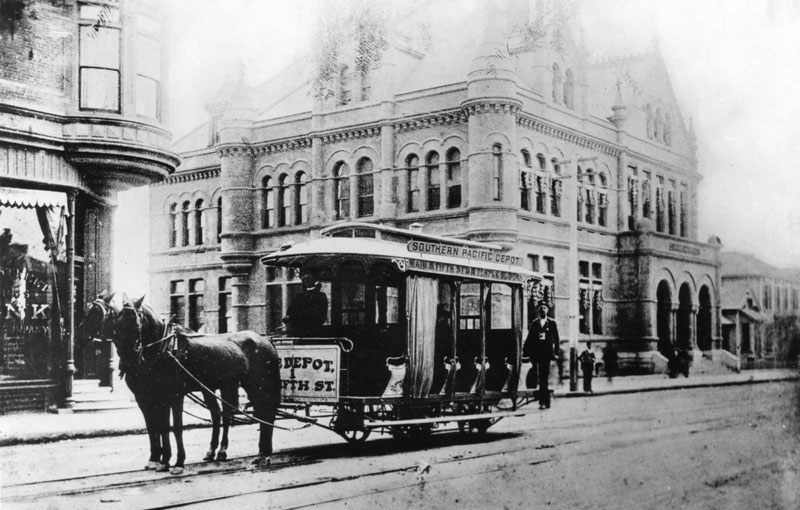 |
|
| (ca. 1880s)^ - A horse-drawn street car stands near the corner of Main and Winston Streets with the Post Office and Federal Building (aka Government Building) in the background. Its route is between the Southern Pacific Depot, Main and 5th Streets, and Temple Block. |
Historical Notes Winston Street is located between 4th and 5th Streets. Click HERE to see more Early Views of Main and Winston Streets. |
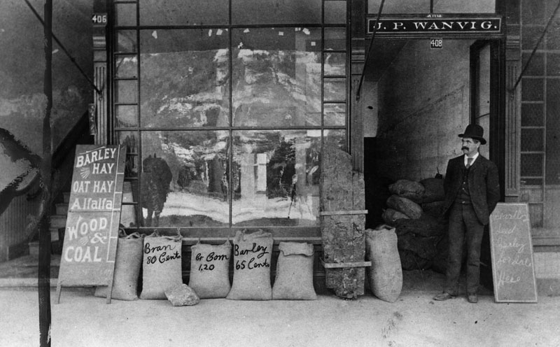 |
|
| (ca. 1880)^ - J.P. Wanvig stands outside his feed store located at 408 Main Street. The signs on the sidewalk advertise barley, hay, oat hay, alfalfa, wood, coal and bran are for sale within the establishment. |
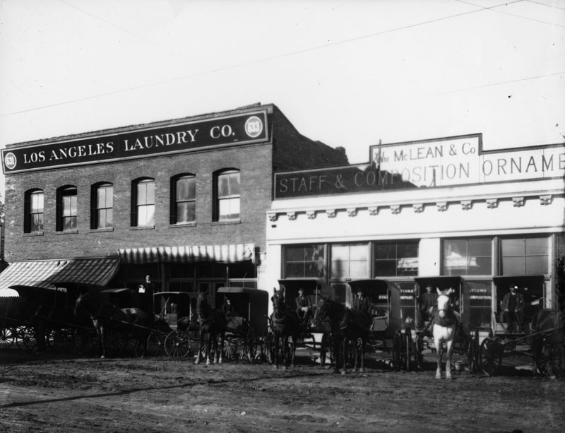 |
|
| (ca. 1880s)^ - Exterior view of Los Angeles Laundry Co. located at 633 San Fernando Street, near Bellevue Avenue. To the right is the William McLean & Co., "Staff and Composition Ornamentations", at 635 San Fernando. Numerous horse-drawn carriages are parked on the unpaved street. |
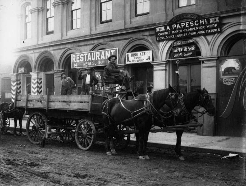 |
|
| (ca. 1880s)^ - A team of horses and a wagon with men on it stand on an unpaved street in front of the general jobbing carpenter shop of A. Papesghi at #10 of an unidentified street, probably in the Plaza area. He is a cabinet maker, does carpenter work, and makes store and office counters and shelving fixtures. A sign above the door reads, "La Plaza Shop." Next door to the left is Hing Kee shoe making and repairing, and beyond that a restaurant selling meals for 15 cents, and a barber shop. To the right is Mathis Brewing Company. |
* * * * * |
Please Support Our CauseWater and Power Associates, Inc. is a non-profit, public service organization dedicated to preserving historical records and photos. We are of the belief that this information should be made available to everyone—for free, without restriction, without limitation and without advertisements. Your generosity allows us to continue to disseminate knowledge of the rich and diverse multicultural history of the greater Los Angeles area; to serve as a resource of historical information; and to assist in the preservation of the city's historic records.
|
More Historical Early Views
Newest Additions
Early LA Buildings and City Views
History of Water and Electricity in Los Angeles
* * * * * |
References and Credits
* DWP - LA Public Library Image Archive
^ LA Public Library Image Archive
*# Historical Society of Southern California: Eternity Street; Phineas Banning
+# A Visit to Old Los Angeles - CSULB.edu
+^ Old Los Angeles and Environs blogspot
#^ Huntington Digital Library Archive
***Los Angeles Historic - Cultural Monuments Listing
*^*California Historical Landmarks Listing (Los Angeles)
*^#Public Art in LA: Campo Santo
*##Metro.net - Los Angeles Transit History
^##California State Library Image Archive
**#The Cable-Car-Guy.com: The Los Angeles Railway
*#*KCET - When the Cahuenga Pass Was Rustic
^*#Noirish Los Angeles - forum.skyscraperpage.com; 2nd and Broadway
^^#CSULB - A Visit to Old LA: Hamburger Dept. Store; Main Street
**^History Matters: Calle de los Negros, 1880s
^^*LA Fire Department Historical Archive
^***Homestead Museum: Workman and Temple Family
^^*#Jewish Museum of the American West: Jacoby Brothers
*^^^Los Angeles Orthopaedic Hospital
*^^*Los Angeles Past: Temple and Main Streets, Los Angeles - Then and Now; Longstreet Palms; Palm Drive Then and Now
*#^#Los Angeles Athletic Club History
**## Mojave Desert.net: Remi Nadeau
#***Photos of Vintage Los Angeles - Facebook.com: 1899 Bunker Hill
#^^#Cal State Pomona Archive: Lichtenberger's Carriage Factory
*^ Wikipedia: Arcadia Bandini de Stearns Baker; Bunker Hill; Prudent Beaudry; Jonathan Temple; Los Angeles High School; Joseph Widney; Pershing Square; Port of Los Angeles; Belmont High School; Hollenbeck Park; Ducommun; Isaias W. Hellman; Abel Stearns; Sawtelle Veterans Home; Arcade Station; Alhambra; Fort Moore; History of Santa Monica; History of Los Angeles; Burbank; John Schumacher; History of Los Angeles Population Growth; Telegraphy; Felix Signoret; Helen Hunt Jackson; Hill Street; Cahuenga Peak; Angelino Heights; LA's Oldest Palm Trees; Cathedral of Saint Vibiana; Harris Newmark
< Back