Early Views of Pasadena
| Historical Photos of Early Pasadena |
 |
|
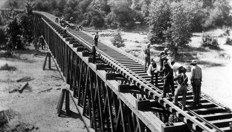
| (ca. 1880s)* - View showing two groups of men building the railroad over the tressels. This area of the tracks is the Los Angeles and San Gabriel Railroad, crossing into Pasadena. |
Historical Background The Los Angeles and San Gabriel Valley Railroad was founded in 1883 by James F. Crank with the goal of bringing a rail line to Pasadena from downtown Los Angeles. Los Angeles and San Gabriel Valley Railroad was sold and consolidated in 1887 into the California Central Railway. In 1889 this was consolidated into Southern California Railway Company. On Jan. 17, 1906 Southern California Railway was sold to the Atchison, Topeka and Santa Fe Railway and called the Pasadena Subdivision. The new rail line through the San Gabriel Valley was a boom to the valley's citrus, nuts and fruit growers, with a new way to get their goods to market.*^ |
 |
|
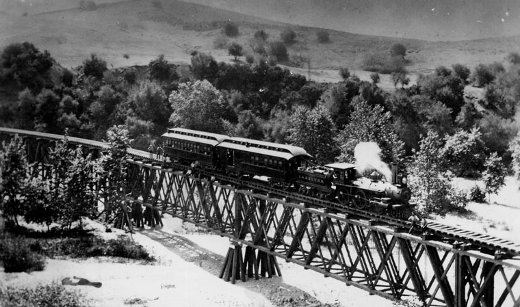
| (ca. 1885)*^ - View showing a Los Angeles and San Gabriel Railroad train on the bridge at Garvanza, the first trestle across the Arroyo Seco, approaching Highland Park from South Pasadena. The trestle, which was replaced later by the Santa Fe trestle, extends out from the forest, supporting a steam engine trailing two passenger cars behind it. Two men stand on the tracks at back, one with his hand on the last passenger car. Two more men stand to the side of the tracks in front of the engine. |
.jpg)
Historical Background With the goal of connecting all of the San Gabriel Valley, in November of 1886 the Los Angeles and San Gabriel Valley Railroad started building a line West from Mud Springs (what is now San Dimas). By January 1887 the rail had crossed the San Gabriel River in Azusa. In 1887 the line continued to Monrovia where a wooden structure rail station depot was built. This structure was replaced by the Santa Fe Depot which was built in 1926.*^ |
 |
|
| (1886)*^ - Map of the Los Angeles and San Gabriel Valley Railroad showing the location of the Arroyo Seco Bridge. |
Historical Background With the May 20, 1887 sale of the Los Angeles and San Gabriel Valley Railroad to the California Central Railway, (a subsidiary railroad of the Atchison, Topeka and Santa Fe Railway) the two lines where connected together at Mud Springs, completing the rail line from Chicago to Los Angeles through the San Gabriel Valley.*^ |
Arroyo Seco Bridges
 |
|
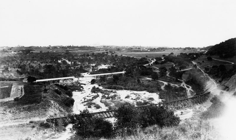
| (1891)* - Panoramic view of two railroad bridges in Arroyo Seco, in Pasadena. |
Historical Background The Arroyo Seco region can be considered by historical accounts as the birthplace of Pasadena. After the 1820s secularization of the Missions, the broad area to the east of the Arroyo was the Mexican land grant of Rancho San Pascual, present-day Pasadena, California. Manuel Garfias was the grantee of the Rancho and its longest early resident. His adobe house was on the east ridge of the Arroyo, in present-day South Pasadena. With the 1874 establishment of the community of the Indiana Colony, the new residents built their homes along today's Orange Grove Boulevard, the major north-south avenue paralleling the Arroyo on the east. However, the deep and seasonally flooded Arroyo presented a barrier to easy travel and transportation between renamed Pasadena and Los Angeles. Stories of four and five hours just crossing the chasm, whether exaggerated or not, abounded in Pasadena history.*^ |
 |
|
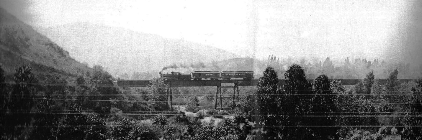
| (ca. 1910)* – View showing the outbound Santa Fe morning local in route from LA to Pasadena crossing the Arroyo Seco. |
Historical Background The Santa Fe line served the San Gabriel Valley until 1994, when the 1994 Northridge earthquake weakened the bridge in Arcadia. In the late 1990s construction of the Gold Line started and opened on July 26, 2003. Thus the old Los Angeles and San Gabriel Valley Railroad right of way (ROW) is still in use today.*^ |
 |
|
| (ca. 1949)* - A Santa Fe mail train crosses the Arroyo Seco (and Route 66) near South Pasadena pulled by engine no. 3444. |
 |
|
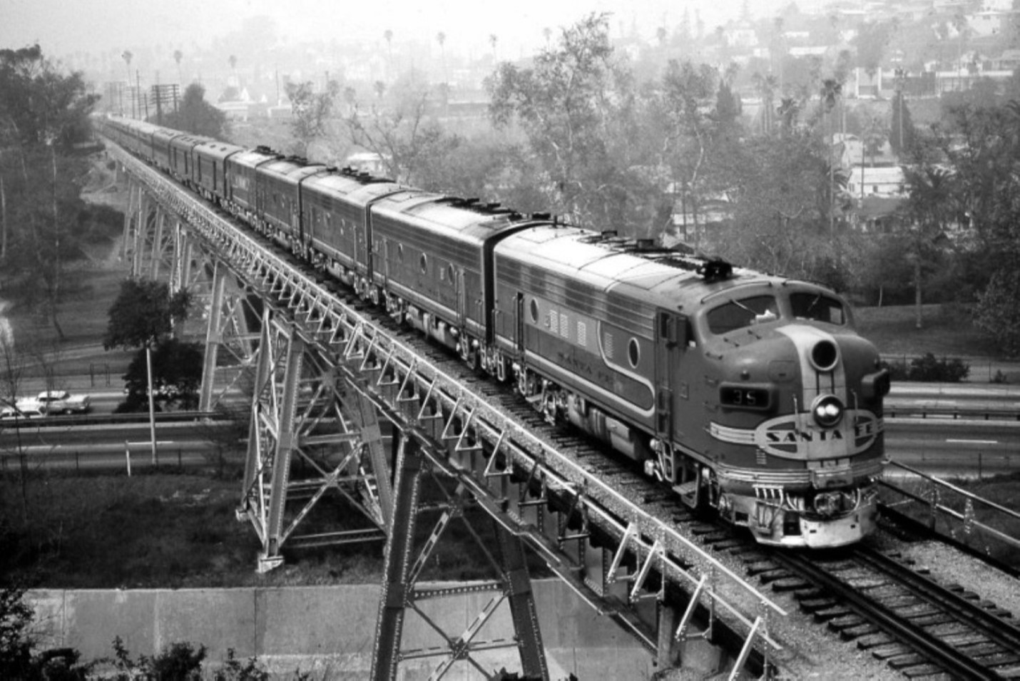
| (1960s)* - The fabled Super Chief crossing the Arroyo Seco. Photo courtesy of Terrence Butcher |
Historical Background The Santa Fe Arroyo Seco Railroad Bridge in Highland Park is the tallest and longest railroad span in the city of Los Angeles, and most likely the oldest such structure still in use. Rail service ended in 1994 and in the late 1990s, the bridge was retrofitted to accommodate the Los Angeles MTA's Gold Line light rail system which opened in 2003.* |
* * * * * |
 |
|
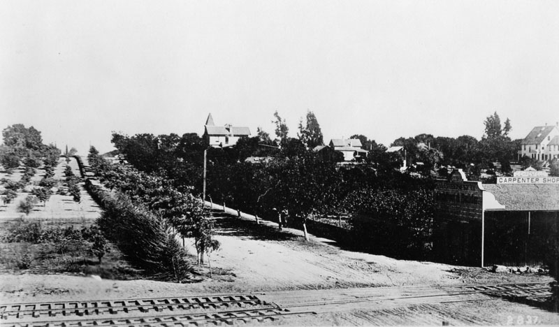
| (1887)* - View of Pasadena, looking east from the Salt Lake Railroad Depot along a rural street (Colorado Street?). The C. Ehrenfeld Carpenter Shop is in the right foreground. Railroad tracks (bottom foreground) run across the street. An orchard is on one side of the street. The residence of Dr. and Jeanne (the author) C. Carr is visible beyond the trees at center. A wooden building in the foreground at right has signs on it reading "C. Ehrenfeld, carpenter shop", "C. Ehrenfeld, architect & builder".^ |
 |
|
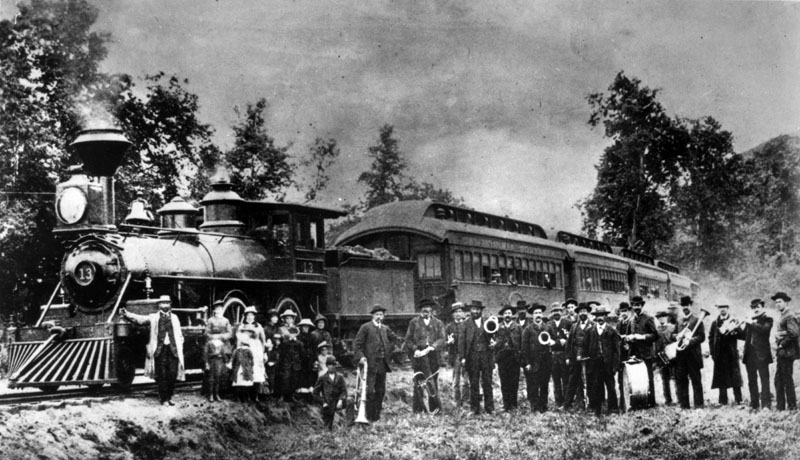
| (ca. 1888)* - Group photo was taken in the Arroyo Seco area. In the background is the California Southern R.R. (now the Santa Fe), locomotive #13, built in 1882. |
 |
|
| (ca. 1888)* - The Los Angeles Terminal Railway in Pasadena near Raymond Hotel in background. |
Historical Background The Los Angeles Terminal Railway, earlier known as the Pasadena Railway, and unofficially as the Altadena Railway, was a small terminal railroad line that was constructed between Altadena and Pasadena, California in the late 1880s. It was a byproduct of a land boom period and a victim of the land bust that occurred soon thereafter. It opened officially on January 31, 1888. The service was originally organized as the Pasadena Railway Company in 1887 by investors John Woodbury, James Swartout, and the two prominent and wealthy Altadenans, Andrew McNally and Col. G. G. Green (aka) George Gill Green, mutual friends from with McNally from Chicago and Green from Woodbury, New Jersey.*^ Andrew McNally was the co-founder of the famed map making company Rand McNally in Chicago and had retired to Altadena in 1887. Green had made his fortunes in patent medicines and elixirs with his company based in Woodbury, New Jersey and was invited by McNally to move to Altadena in the same year. McNally and Green were heavily invested in the small railway, and each had a siding for his own private car to be pulled up alongside their properties which stood on either side of Santa Rosa Avenue from each other.*^ |
Andrew McNally Residence
 |
|
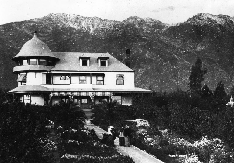
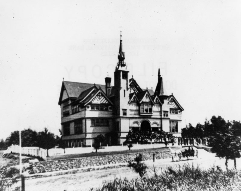
| (1888)* - View showing several people in front of the Andrew McNally residence in Altadena. The Queen Anne mansion is almost hidden by the palms. Frederick Louis Roehrig designed the home. |
Historical Background Andrew McNally was born in Armagh, Northern Ireland, and immigrated to New York City in 1857. A printer by trade, he moved to Chicago in 1858 and got a job in a print shop owned by William Rand at a wage of $9 per week. Rand and McNally became business partners and incorporated Rand, McNally & Co. in 1868, becoming one of the largest and best-known map publishers in history. After Rand retired in 1899, McNally was president until his unexpected death from pneumonia in 1904 at his winter home in Altadena. For nearly 100 years the company was majority owned and headed by several generations of the McNally family. In 1997, the family divested its majority stake for a reported $500 million.*^ |
 |
|
| (1888)* - Exterior view of the Andrew McNally residence on Mariposa Street in Altadena, with the San Gabriel Mountains in the background. |
Historical Background The McNally Queen Anne mansion was designed by architect Frederick Louis Roehrig and built in 1888. It is listed in the National Register of Historic Places.*^ |
 |
|
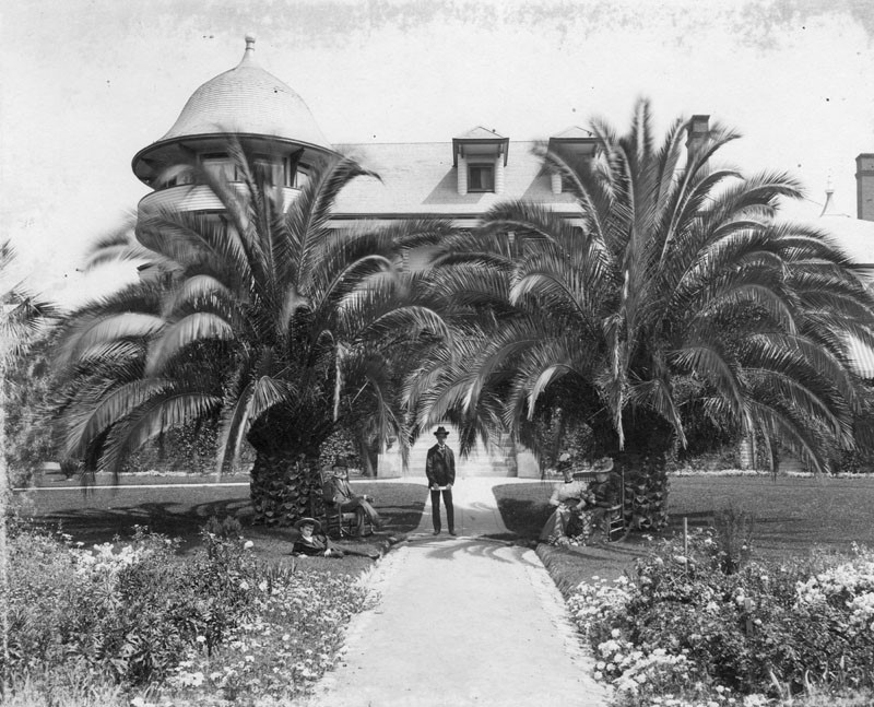
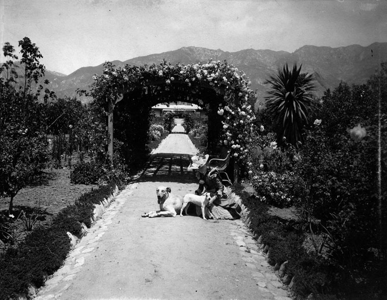
| (ca. 1888)* - View of a woman and two dogs on the path of the garden at the home of Andrew McNally, the well-known Chicago publisher. A partial view of the home may be seen past the arch of roses. Home is located on Mariposa Street and Santa Rosa Avenue in Altadena. |
Historical Background McNally paid Pasadena architect Frederick Roehrig $15,000 to design the Victorian house. Facing south, away from the street, the house offered vistas of the Los Angeles Basin, the Pacific Ocean, and Santa Catalina Island. The house has a three-story rotunda that allows a view to the San Gabriel Mountains to the north. McNally also built a private rail spur from Altadena Junction to his property to store his private railroad car.*^ |
 |
|
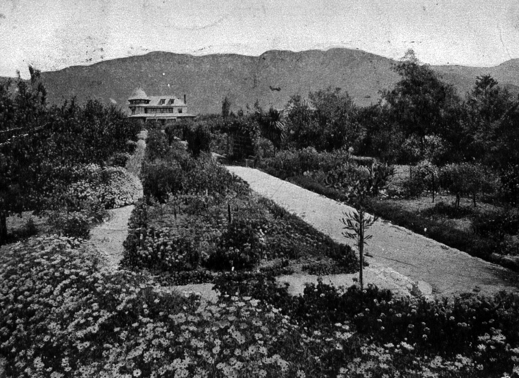
| (ca. 1900)*^ - Postcard view showing the McNally Residence and gardens. |
Historical Background The grounds were lavishly landscaped, with an aviary along Mariposa St. McNally's gardener also looked after the deodar cedars that grew along Santa Rosa Avenue. These trees became Christmas Tree Lane, which is also listed in the National Register. In 1904, McNally caught pneumonia while in route to his Windemere Ranch in La Mirada (The ranch headquarters is also listed in the National Register). He died shortly afterward. The gardens and aviary were neglected and some of the birds escaped. The property was then subdivided.*^ |
 |
|
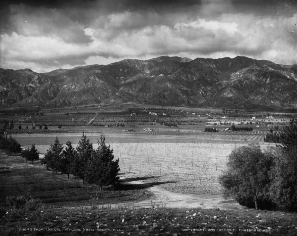
| (1899)* - View of Mt. Lowe from Monk's Hill on a cloudy day. Note the orange groves and vineyards in the foreground. The Echo Mountain House can be seen in the San Gabriel Mountains (top-center). On closer look you can make out Christmas Tree Lane with deodar saplings in the middle of photo. The McNally and Greene mansions are those buildings on either side. The dirt intersection in foreground is of Howard and Marengo. |
* * * * * |
Christmas Tree Lane
 |
|
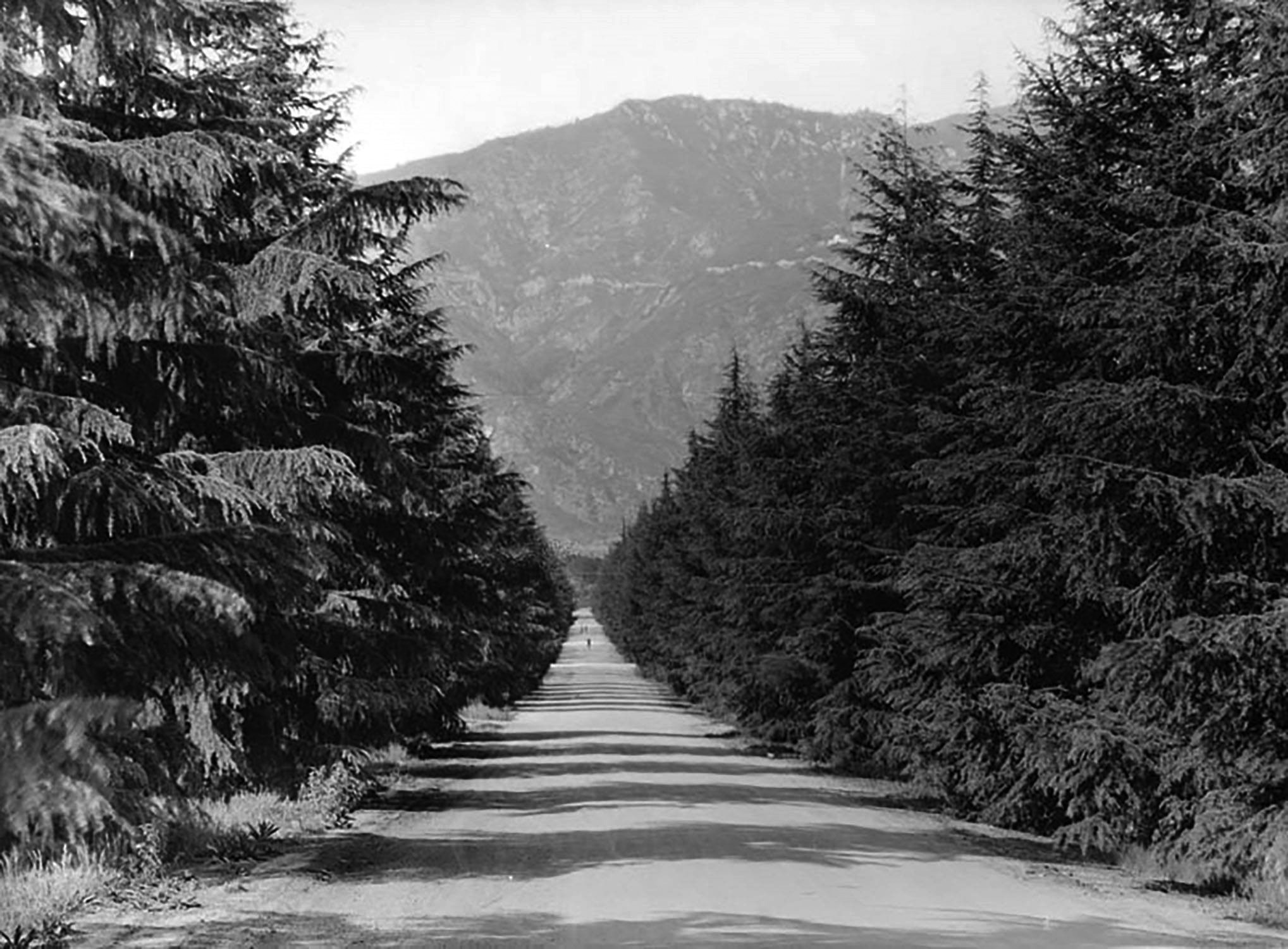
| (1915)* – View looking north along Santa Rosa Avenue in Altadena. This image was published five years before the holiday lighting tradition began and before the street became known as Christmas Tree Lane. |
Historical Background In 1885, real estate developer John P. Woodbury of the Woodbury family, founders of Altadena, planted 134 deodar cedar trees (Cedrus deodara) as part of a planned mile long entrance drive to a large estate he intended to build. The goal was to create a grand, park like boulevard that would enhance the surrounding land and attract development. The mansion was never constructed, but the trees flourished. Over time, the planned entrance drive became Santa Rosa Avenue, defined by the tall, evenly spaced deodar cedars that gave the street its distinctive character. |
.jpg) |
|
| (ca. 1928)* - Passengers in a car travel south on Santa Rosa Avenue, also known as Christmas Tree Lane in Altadena. The nickname was given to the street when the tradition of lighting the large deodar cedars with lights at Christmas time was started. Location: Santa Rosa Ave, both sides of street from Woodbury Rd to Altadena Dr, Altadena. |
Historical Notes The deodar cedar trees lining Santa Rosa Avenue were planted in 1885 as part of John P. Woodbury’s plan for a grand boulevard leading to a proposed estate. Although the mansion was never built, the trees shaped the street’s identity and created the setting that later made it ideal for a large scale holiday lighting display. The holiday lighting tradition began in 1920, when local residents and civic leaders decorated a portion of the street to celebrate the season. The display was well received and quickly became a yearly event. By the late 1920s, Christmas Tree Lane had become a popular destination for evening drives. Families slowly traveled the road to enjoy the lights, making it one of Southern California’s earliest and most enduring holiday traditions. |
 |
|
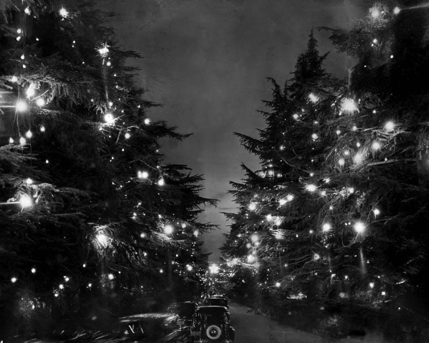
| (1938)* – A line of cars moves slowly beneath illuminated trees along Christmas Tree Lane during the holiday season. |
Historical Notes By the 1930s, Christmas Tree Lane was firmly established as a regional attraction. Visitors arrived by automobile from across the Los Angeles area, reflecting the growing car culture of the time. Traffic often moved at a walking pace, allowing drivers and passengers to fully experience the lights overhead. The trees created a tunnel like effect that made the drive feel both festive and intimate. Even during the Great Depression, the lights continued to be displayed. The tradition offered a sense of comfort and normalcy during difficult years. |
 |
|
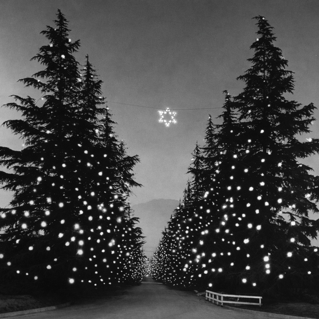
| (ca. 1947)* – Postwar view of Christmas Tree Lane showing the mile long stretch of illuminated deodar cedar trees. |
Historical Notes After World War II, Christmas Tree Lane returned as a bright symbol of peace and community. The postwar years helped solidify the name Christmas Tree Lane, which became widely used in newspapers and postcards. The Lane was not lit every year. During the mid 1940s, the lights were turned off for two seasons due to water shortages that affected hydroelectric power generation. The pause was temporary, and the tradition soon resumed. By the late 1940s, the display had grown into the full mile long stretch that continues today, maintained entirely by community effort. |
 |
|
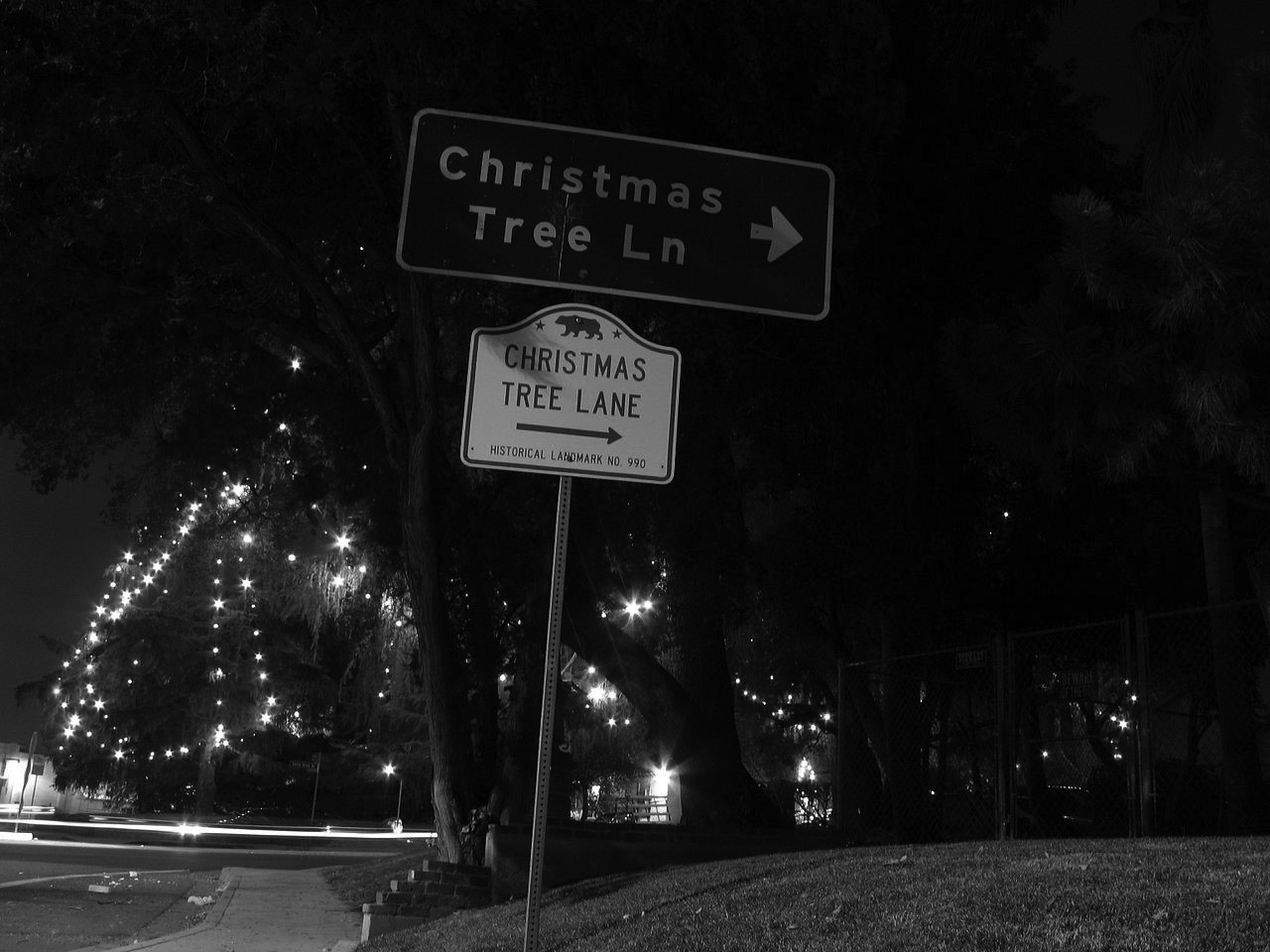
| (2006)* - Road sign marking Christmas Tree Lane, officially recognized as a California Historical Landmark. |
Historical Notes Christmas Tree Lane is designated California Historical Landmark No. 990. The designation recognizes both the historic deodar cedar trees and the long running holiday lighting tradition. The display is organized and maintained by volunteers. Each year, community members spend weeks repairing lights, testing wiring, and raising the strands into the trees using methods that have changed little over time. Christmas Tree Lane remains one of the oldest continuous holiday lighting traditions in the western United States. In early 2025, Altadena was affected by severe wildfires that damaged and destroyed thousands of homes, creating one of the most devastating disasters in the area’s history. Despite the destruction, the community chose to continue the Christmas Tree Lane tradition. Lighting the trees that year became a quiet act of resilience, offering comfort, continuity, and a shared sense of hope during a long period of recovery. |
* * * * * |
First Methodist Church
 |
|
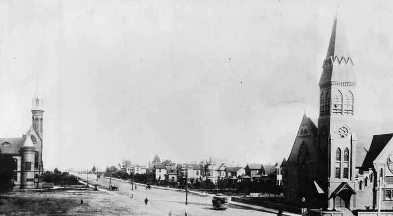
| (ca. 1888)* - View of Colorado Blvd. in Pasadena looking east from Marengo Ave. The church at right is First Methodist Church. The church at left is Pasadena Presbyterian Church, located on the northwest corner of Garfield Avenue and Colorado. |
Historical Background The United Methodist Congregation purchased land on the “hill” at the southeast corner of Colorado and Marengo. On March 20, 1887, a frame church with a 140-foot steeple and an adjacent eight-room parsonage were dedicated. The First Methodist Church was completed in 1888 and was also used as a kind of town hall. Susan B. Anthony and Dwight L. Moody spoke there, and the Siamese twins, Chang and Eng, displayed themselves there. Temperance, women’s suffrage and slavery were important issues at the time.*#^ |
 |
|
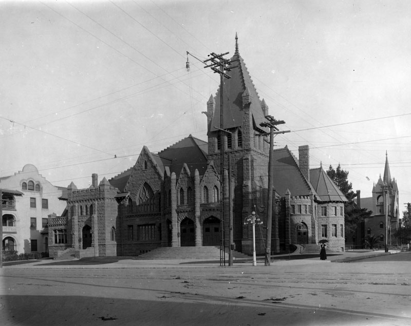
| (ca. 1901)* - Exterior view of First Methodist Episcopal Church at the southeast corner of Colorado Street and Marengo Avenue, in Pasadena; architect, John C. Austin. Portion of La Geralda Hotel shows at the left. |
Historical Background After the first church building was damaged by a tornado, a large stone church was built and dedicated on December 15, 1901 on the same corner. In 1923, the First Methodist Congregation completed its third church building located on Colorado Boulevard at Oakland Avenue where it resides today.*#^ |
Garfield School
 |
|
| (1888)* - Exterior view of Garfield School located in Pasadena. A horse-drawn carriage is parked in front of the school. |
Historical Background Built in 1888, Garfield School was located on the northeast corner of California Street and Pasadena Ave. It was first called the California Street School.** |
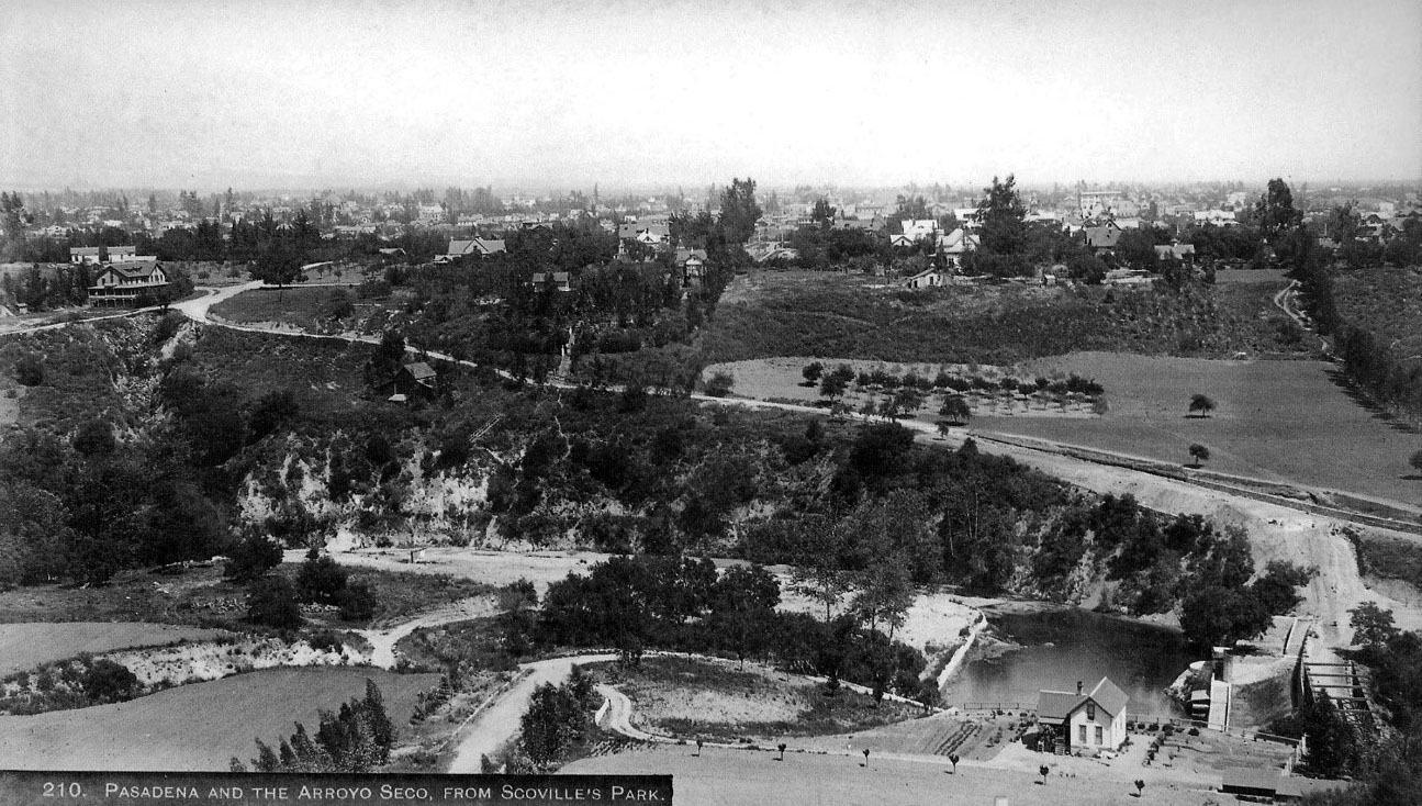
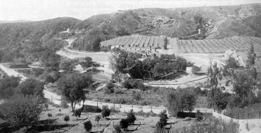
Scoville Bridge
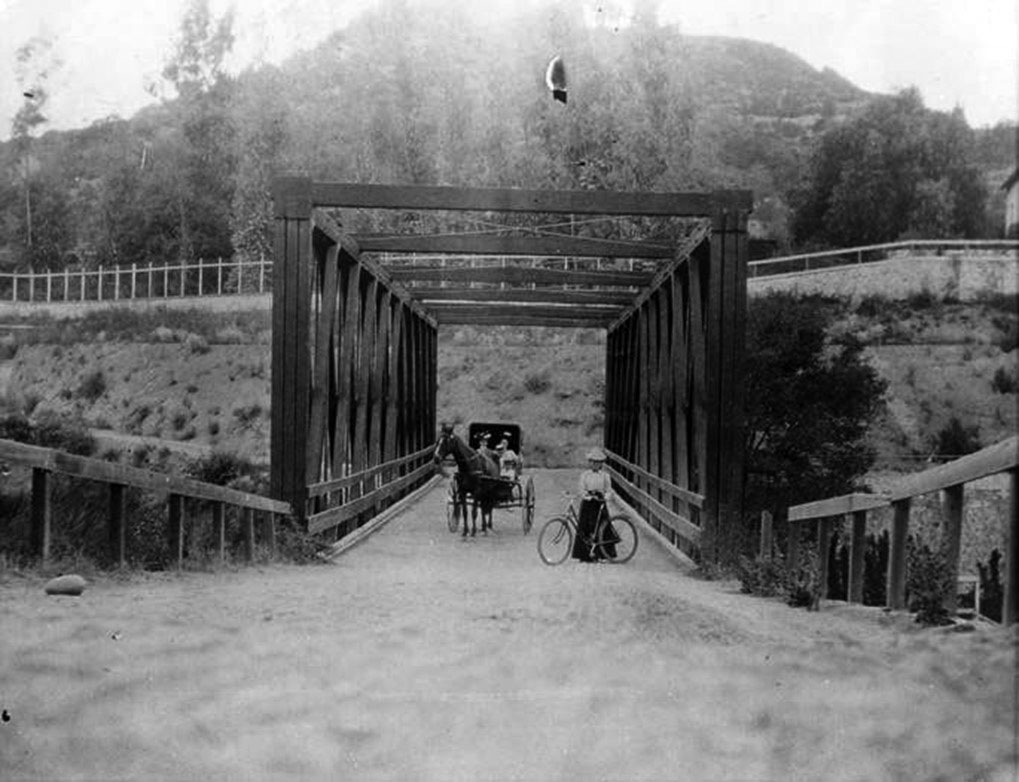 |
|
| (1889)* - The Scoville Bridge traversed the stream of the Arroyo Seco but still required travelers to descend into the ravine and then climb the opposite bank after crossing. |
Historical Background Pasadena was founded where it was exactly to take advantage of a reliable water supply, the Arroyo Seco ("Dry Gulch" in English). It was a reliable source of water in a rather dry environment. However the Arroyo Seco was also a problem, it was deep in a steep sided canyon. This meant that Pasadena was physically isolated from its western neighbors. Travelers would have to make long detours passable crossing north or south of Pasadena. This was finally changed by James Scoville who built his bridge in 1887. * |
 |
|
| (ca. 1890)++# - View looking east showing the Scoville Dam, Scoville Bridge, and City of Pasadena beyond. The dam and bridge are in the lower right corner. |
Historical Background Arroyo Drive crosses right to left rising to the junction with what is now W. Holly Street at left. W. Holly continues east to its intersection with N. Grand St., which at the time was connected to S. Grand Street below Colorado, and west to the Linda Vista Bridge. The Green Hotel can be made out at rear right. The place where the photo was taken was itself obliterated by the construction of the 134 Freeway.++# |
 |
|
| (ca. 1905)++# - View of the Scoville Bridge, Dam and surrounding area. Photograph by A.C. Vroman. The dam and bridge were built 1887-1903; Note: S. Arroyo Blvd. is in the foreground. |
Historical Background James Scoville had been the Vice President of the Elgin Watch Co., President of the Prairie State Bank, and a trustee of what would later be known as California Institute of Technology. He built a pleasure garden on the bluff above the Arroyo Seco which went down the slope of the canyon walls to the stream itself. There he built a small dam and pump house. The top of the dam served as the eastern abutment of a wooden bridge, the first to connect Pasadena to the western side of the Arroyo. * |
.jpg) |
|
| (ca. 1905)++# – Closer view showing the Scoville Bridge, Dam and Pump House. |
Historical Background Scoville commissioned the construction of a timber truss-leg bridge to improve hauling, and a dam to provide water for irrigating crops and generating power. The bridge was a reused train trestle, left unused by the Atchison, Topeka and Santa Fe Railroad. The trestle was placed upside-down across the stream bed, and set in a concrete foundation on either side.* |
Colorado Street Bridge
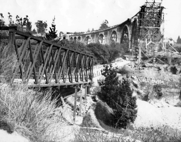 |
|
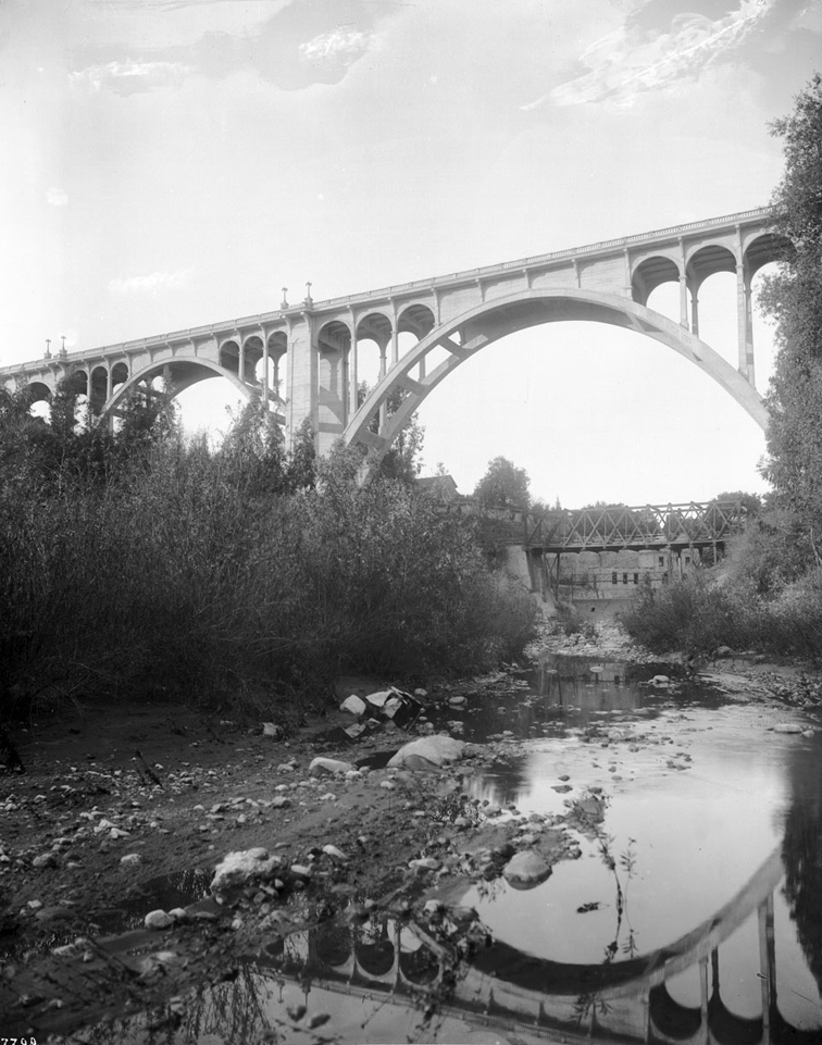
| (ca. 1913)*#* - A view of the Scoville Bridge next to the partially completed Colorado Street Bridge. |
Historical Background Scoville Bridge was still in service when the much larger and grander Colorado Blvd. Bridge was built above it. |
 |
|
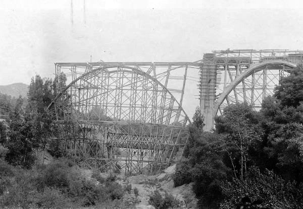
| (1913)^ - View looking north at the Colorado St. Bridge under construction with the Scoville Bridge behind. |
 |
|
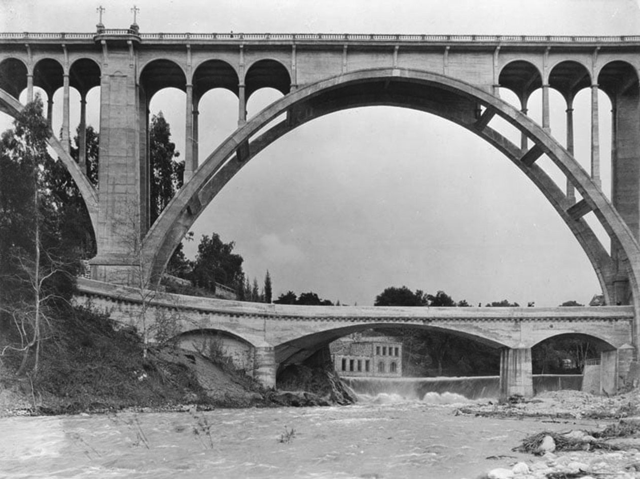
| (1914)^ - View looking up towards the newly completed Colorado Street Bridge. In the distance stands the Scoville Bridge shortly before a flood brought it down. |
Historical Background Scoville's original bridge survived until the flood of 1914, when the trestle was carried all the way down the Arroyo Seco and into the Los Angeles River. ++# Click HERE to see more early views of the Colorado Street Bridge. |
Parker-Mayberry Bridge
 |
|
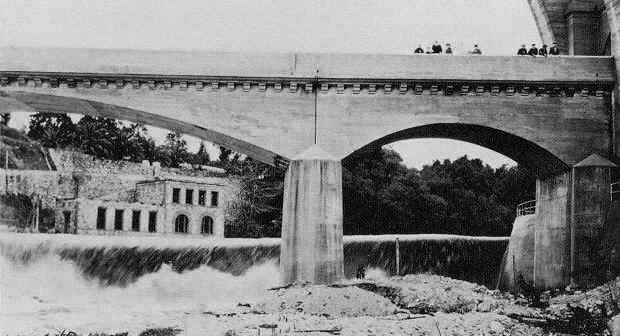
| (1919)* - The Parker-Mayberry Bridge, shortly after being completed with the Colorado Street Bridge right behind it. It replaced the Scoville Bridge which was destroyed by a flood in 1914. |
Historical Background Six months after the opening of the Colorado Street Bridge, a new bridge to cross the stream below it was commissioned by William Smith Mason of Chicago to give access to his property on the west side of the Arroyo, the new bridge was to be of reinforced concrete. The old Scoville Bridge and dam had been washed out in floods in early 1914, limiting Mason’s access to his property. The new bridge and dam, designed in conjunction with architectural engineers Edward Mayberry and Llewellyn Parker, spanned the stream directly beneath the piers of the big bridge, with graceful arches curving over its narrow roadway, only 18 feet wide on the eastern approach, but widening to 60 feet on the west. |
 |
|
| (ca. 1920)^ - View of the Parker-Mayberry Bridge built to replace the Scoville Bridge. The Colorado Street Bridge is seen at upper-right. The structure at left rear is the pump house which contained the equipment necessary to pump water from the Scoville Dam up to the Orange Groves on the east side of the Arroyo. |
Historical Background The new Parker-Mayberry Bridge was approximately 150 feet long with a single broad arch over the stream. The design for the new bridge used classical details to harmonize with the main bridge above. The cost of about $50,000 was borne by Mr. Mason. |
 |
|
| (2022)* - A hiking group walks over the Parker-Mayberry Bridge with the Colorado Street Bridge directly above. Photo by Martin Thompson |
* * * * * |
 |
|
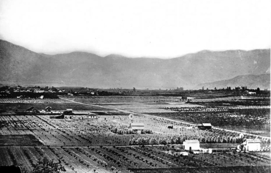
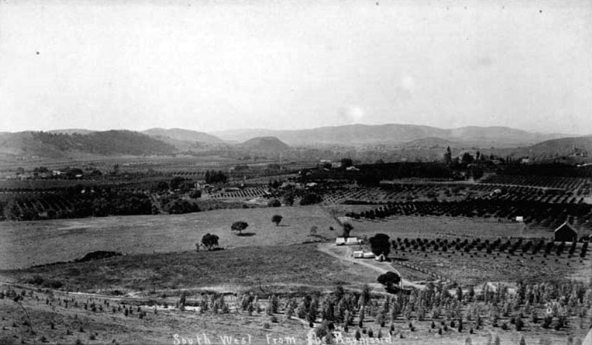
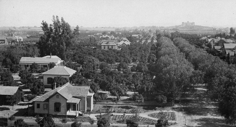
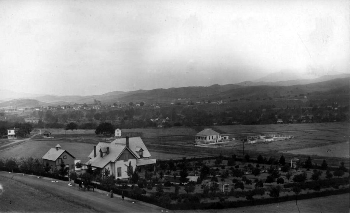
| (ca. 1889)^ - Panoramic view of Pasadena looking north from Raymond Hill. Sparse houses are separated by burgeoning agricultural fields. A house with a windmill-style weathervane stands at center and the San Gabriel Mountains are visible in the background. |
 |
|
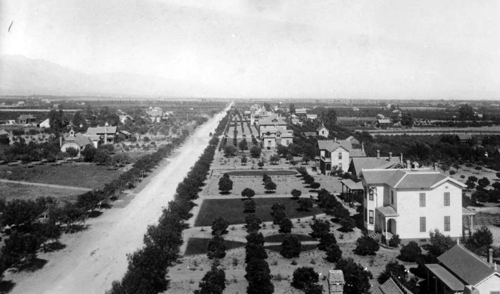
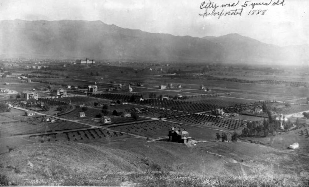
| (ca. 1889)*^* – Panoramic view of Pasadena looking south from the Methodist Episcopal Church on corner of Colorado St. & Marengo Ave. Orange groves are seen in the southwest with the Raymond Hotel on the hill in the far distance. A tree-lined dirt street and homes are in the foreground. |
 |
|
| (1889)#*- An elevated street view of Colorado facing east, taken from the Methodist Episcopal Church, at the corner of Colorado and Marengo. The street is residential, with houses set well back behind large lawns. "C.S. Frost & Sons Pasadena, Cal." is printed below the image. A typescript note attached to the top of the image reads "M.E. Church, corner of Colorado St. & Marengo Ave. looking east. 1889." |
.jpg) |
|
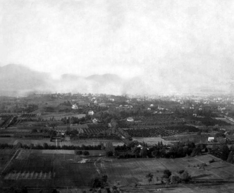
| (ca. 1890)^ - View of Pasadena looking north. The San Gabriel Mountains loom in the background over the closely-situated houses and buildings of the city whose crop rows are interspersed between them. The bell tower of the school at Colorado Street and Fair Oaks Avenue is visible at center about halfway from the bottom of the frame A water tower and a larger building are visible on the horizon in the left distance along with the mountains across the entire background. |
Colorado Street
 |
|
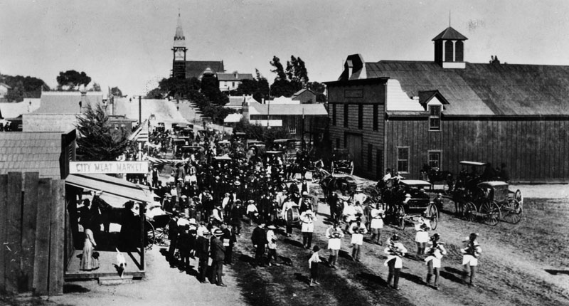
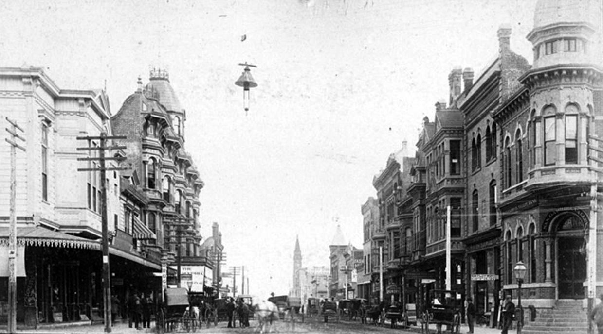
| (1889)* - A brass band heads the funeral cortege of Owen Brown, third son of the famous abolitionist, John Brown. The photo was taken January 10, 1889, looking east from Raymond Avenue along Colorado Blvd. The hill is at Marengo Avenue and was sliced away when Colorado was leveled in later years. The City Meat Market is on the left. |
 |
|
| (ca. 1890)*#* - View of Colorado Boulevard, then named Colorado Street, looking east to Marengo Avenue. Horse-drawn wagons with displaying america flags appear to be in a parade (possibly 4th of July). |
 |
|
| (1890)*^* – View showing a horse-drawn streetcar on Colorado Street where Oakland now intersects. |
Old Town Pasadena
 |
|
| (ca. 1887)*^* - Memorial Day Parade looking east on Colorado Street at Fair Oaks. The Carlton Hotel (built in 1886) is seen on the left. San Gabriel Valley Bank is on the right. |
 |
|
| (1887)** – View looking east along Colorado Street from Fair Oaks Avenue showing horse-drawn wagons parked along the curb. The Carlton Hotel stands on the left. |
Historical Notes Colorado Street was lined with shops and restaurants, and parking could at times be an issue. In the 1880s, parking was still a matter of finding a place to leave one's horse and carriage. |
 |
|
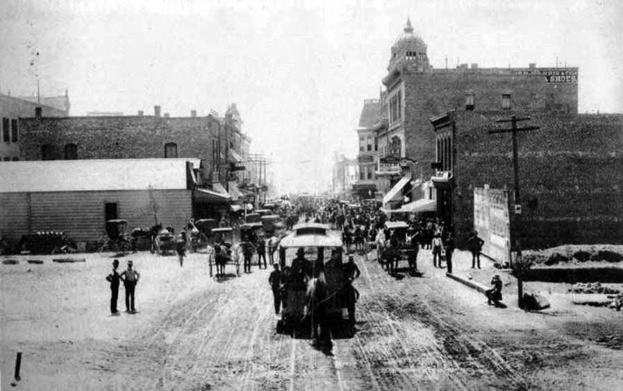
| (ca. 1889)** - View of Fair Oaks Avenue looking south to Colorado. At center, a horse-drawn trolley moves toward the camera. In the background, a very congested Fair Oaks Avenue with scores of horse-drawn carriages on both sides of the street. |
Historical Notes Residents would come here for shopping, community gatherings, or entertainment. Despite Pasadena's relatively small population, this densely compacted commercial district had the excitement and activity found in much larger cities. Colorado Street was frequently filled with horses, buggies, wagons, and pedestrians, along with horse-drawn streetcars in the late 1880s. |
 |
|
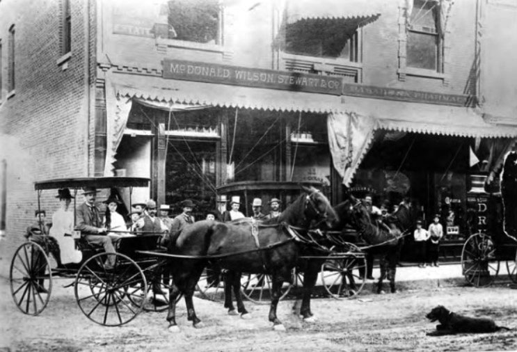
| (ca. 1889)** - This photo displays the buildings located on North Fair Oaks Avenue near the intersection of Fair Oaks and Colorado Boulevard in the year 1889. View shows a horse and buggy, several men and women, and a dog on the unpaved road in the foreground. |
Historical Notes The windows display the real estate company of McDonald, Wilson, Stewart & Co. at No. 11 N. Fair Oaks and the druggist J.H. Bellan & Co. at No 9. Although the western side of Fair Oaks maintains even addresses today, the decreasing numbers as one goes to the right suggest that this is the East side of the street. These buildings are also next to Barney Williams' Hall, one of the first buildings built at this intersection and Pasadena's center for entertainment at that time.** |
 |
|
| (1890)* - Colorado Street (now Boulevard) near Fair Oaks Avenue in 1890. The large building at center-right is the Carlton Hotel. |
Historical Notes Colorado Street was renamed "Boulevard" through Old Town Pasadena from Arroyo Parkway to Orange Grove Boulevard in 1958.*^ |
 |
|
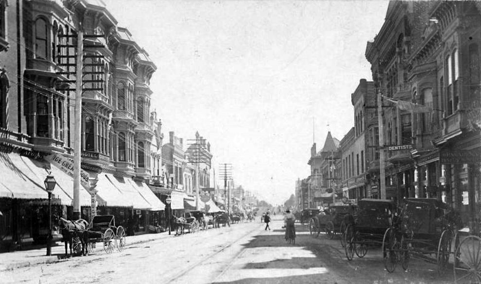
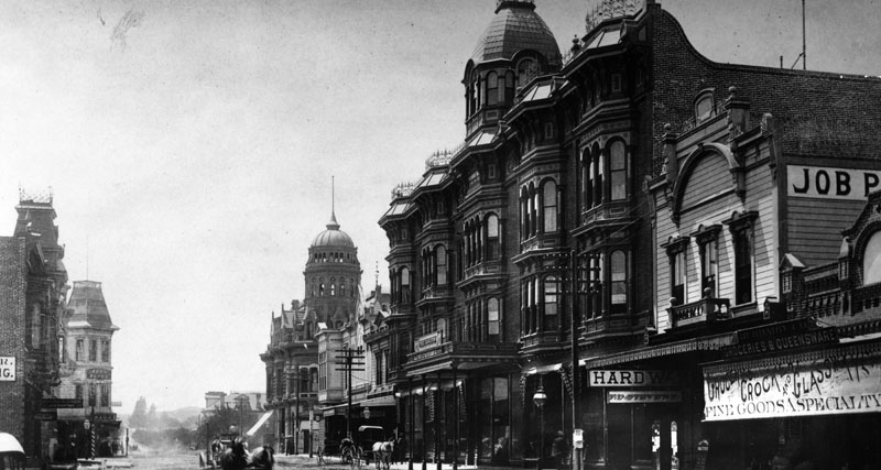
| (1890)* - View of Colorado and Fair Oaks Avenue in Pasadena, in 1890. Many storefronts can be seen on both sides of the street. On the left, there is: San Gabriel Valley Bank, a Drugs store and a Boots and Shoe store. On the right, there is: Oneill & Johnson Real Estate Insurance, a candy factory, Phillips Land & Real Estate Loans, and also the Ward Block building which includes the First National Bank. A trolley runs down the middle of the street and shares the road with horse-drawn vehicles. |
 |
|
| (ca. 1890)*^* - Photo showing a vibrant day on Colorado Street (later Boulevard) looking east from Fair Oaks. The San Gabriel Valley Bank is at right (S/E corner). A streetlight hangs over the middle of the intersection. |
Historical Notes The San Gabriel Valley Bank, the building to the far right, was organized in February 1886 and moved to this location in 1887.*^* |
 |
|
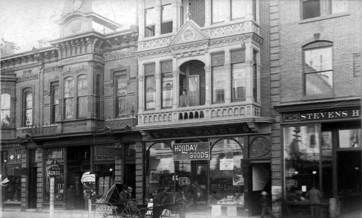
| (ca. 1890)** – View looking at the south side of Colorado Street just east of Fair Oaks showing a series of connected buildings, also referred to as the Fish Block, covering 24-28 E. Colorado. Signs include: PASADENA STEAM LAUNDRY, HOLIDAY GOODS, and WOOD & BANBURY REAL ESTATE. A horse-drawn carriage with passengers is parked in the foreground of the photo. |
Historical Notes The Fish Block on 26 E. Colorado Street was the YMCA headquarters in 1890. Built by Mr. Milford Fish in 1887, it was the site of offices of two Iowans: Mr. Wood and Mr. Banbury (one of Pasadena's founders). ** |
Pasadena's First Theater
 |
|
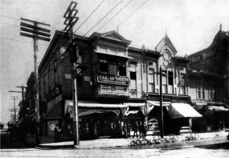
| (1890s)** - Exterior view of the Williams Hall Parlor Theatre, Pasadena's first theatre. It was located on the Exchange Block at Colorado. On the left side of the building we're looking north up Fair Oaks Ave. |
Historical Background The Williams Hall Parlor Theatre was Pasadena's first theatre. It was located on the northeast corner of Colorado Blvd. and Fair Oaks Ave. in second floor space.** |
* * * * * |
 |
|
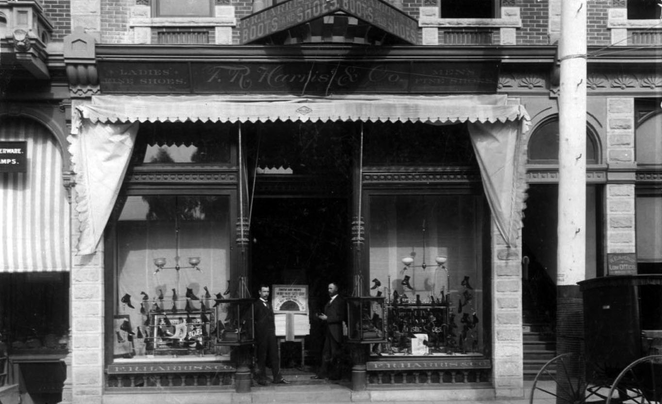
| (ca. 1892)** – Two men stand in the entryway of the Harris Shoe Store located on the north side of Colorado, near Raymond. |
Historical Notes The Harris Shoe Store was located at 7 - 9 West Colorado. Proprietor, F. R. Harris, is standing on left, and clerk C. D. Sargent is standing right. ** |
 |
|
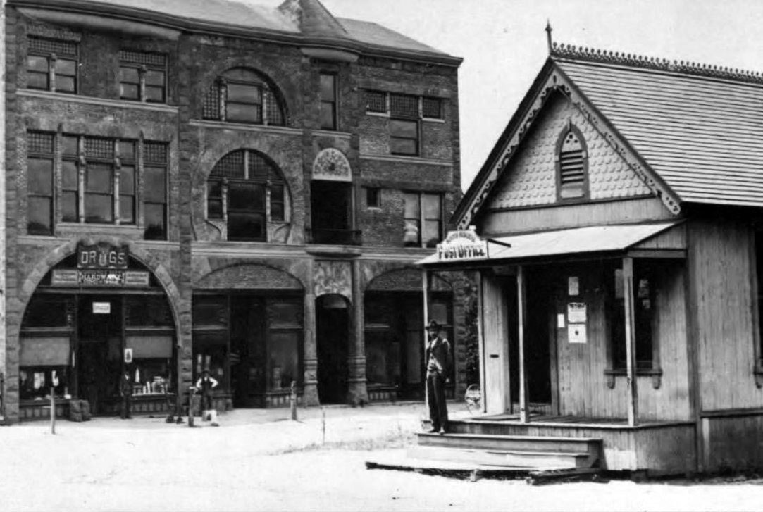
| (ca. 1888)^#^^ – South Pasadena Postcard showing Opera House Building and Post Office. |
 |
|
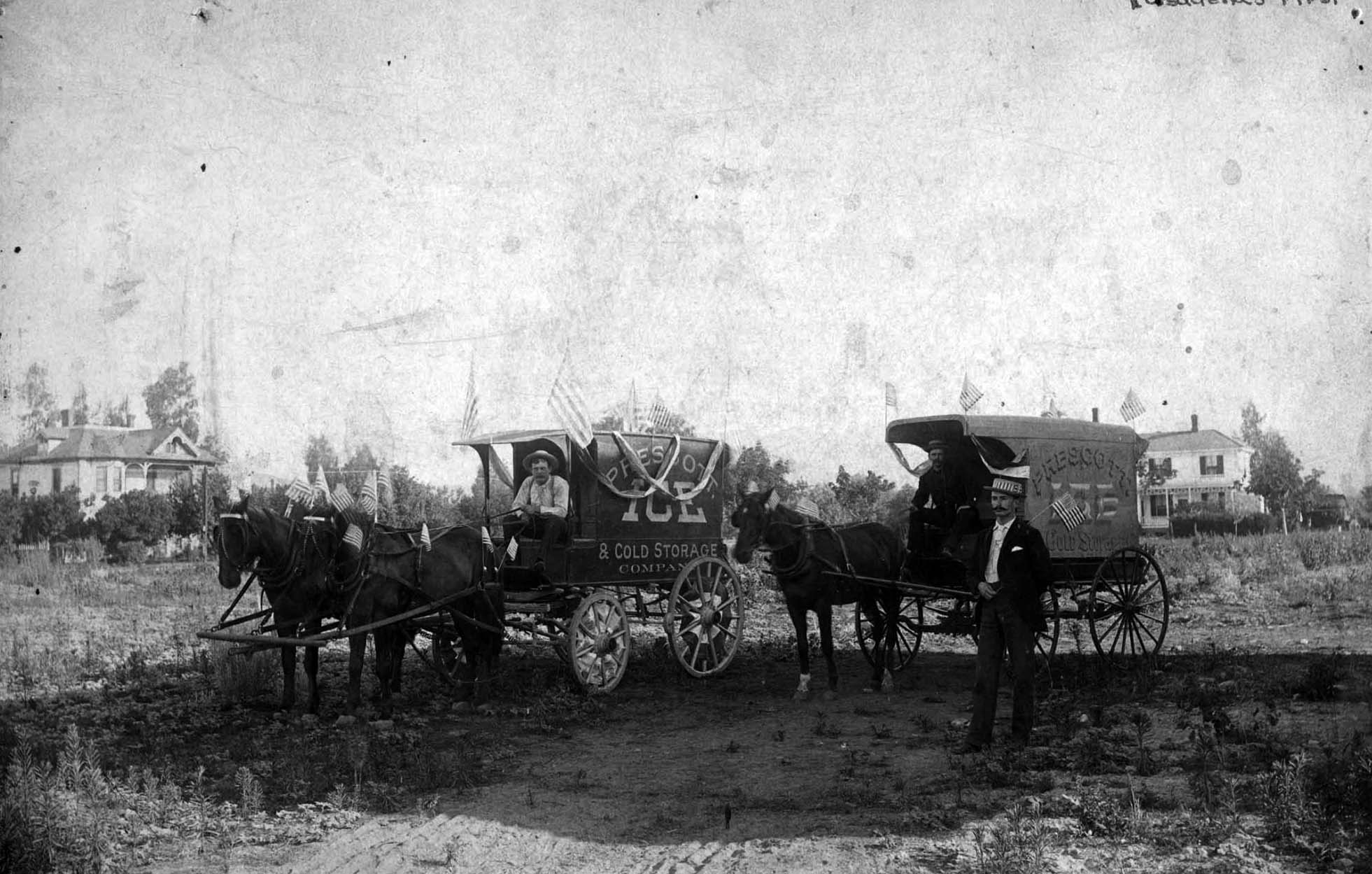
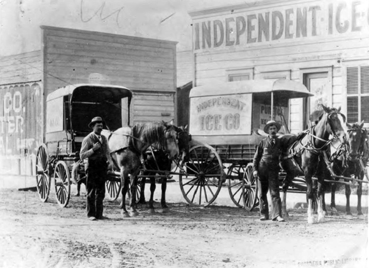
| (1889)*^* - Pasadena has ice for sale on July 4, 1889. Happy 4th of July! Caption reads “First Ice Wagons in Pasadena”. |
Historical Notes Founded in 1889 by J.C. Rust, the Independent Ice Company initially sold 'natural ice' shipped from Truckee. |
 |
|
| (ca. 1890)** - View showing the Independent Ice Company located on the northwest corner of Union and Raymond. |
Historical Notes In the photo J.C. Rust is on the left and his younger brother, S.L. Rust, is on the right. |
Pasadena Grand Opera House
 |
|
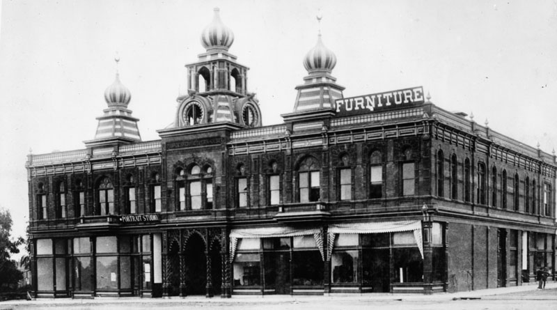
| (1889)* - Exterior view of the Pasadena Grand Opera House. A sign reading 'Furniture' sits on the right side of the roof line. |
Historical Notes The Grand Opera House was built in 1888 by the Grand Opera House Company and opened on February 13, 1889. The new opera company was formed a year earlier by E. C. Webster, Senator L. J. Rose, F. M. Ward, and Roscoe Thomas. The building was done in Moorish architecture, a style popular of the times. Ornately decorated with bronze and guilt, the opera house offered beauty rarely seen before. The very best of carpenters, artisans, and mechanical specialists were brought in to spare no expense in providing Pasadena with a world class opera house. Seating capacity was 1500 of which 900 seats were on the main floor and 600 were in the balcony. The main floor seats were on tiers that raised 18 inches for each row affording all the best of views. The folding back chairs were not only cushioned but held hat and umbrella racks. During 1890 the opera house steadily declined. Many thought it was because of being too far from the center of town. Others complained there was no heat causing uncomfortable situations for its patrons. Location, amenities, and plain old financial troubles caused the Opera House to be in a woeful condition by the end of 1890. The opera house was closed and bids were sought for its demolition and resale of the fixtures and furniture. By May of 1891 the Grand Opera House Company was bankrupt.^**^ |
 |
|
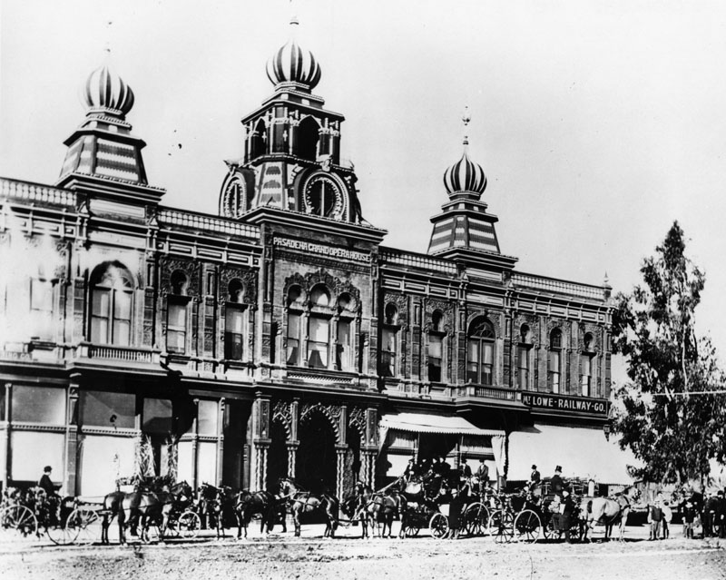
| (1891)* - View of the ornate facade of the Pasadena Grand Opera House with horses and carriages in front. A sign reading: "Mt. Lowe Railway Co." is seen on the right. |
Historical Notes In mid-1891 Thaddeus Lowe successfully negotiated with Senator Rose and the Ward brothers for the purchase of the Grand Opera House at a greatly reduced bankruptcy price. Quickly Lowe set out remodeling the Opera House to accommodate his various holdings. Engineer David Macpherson had offices up on the second floor and drafting rooms were set up for his mountain railway. Lowe had an office on the first floor and planned to sell tickets from it for his scenic railroad. |
 |
|
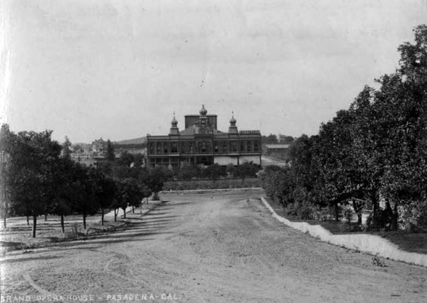
| (1893)^.^ – View showing the façade of the Pasadena Grand Opera House. |
Historical Notes Financial rough times came for Thaddeus Lowe. The scenic Mt Lowe railroad was taking much more money than expected and Lowe defaulted on the mortgage loan of his Orange Grove home and the Grand Opera House. The properties were foreclosed on and sold at auction. In the coming years the property changed hands a number of times, later becoming the Auditorium with fine hotel and eating facilities. By 1926 the grand old building known as the Grand Opera House had been razed and was eventually used by Royal Laundry as their factory and facilities.^**^ Click HERE to see more in Early Views of Mt. Lowe Railway. |
Thaddeus Lowe's Residence
 |
|
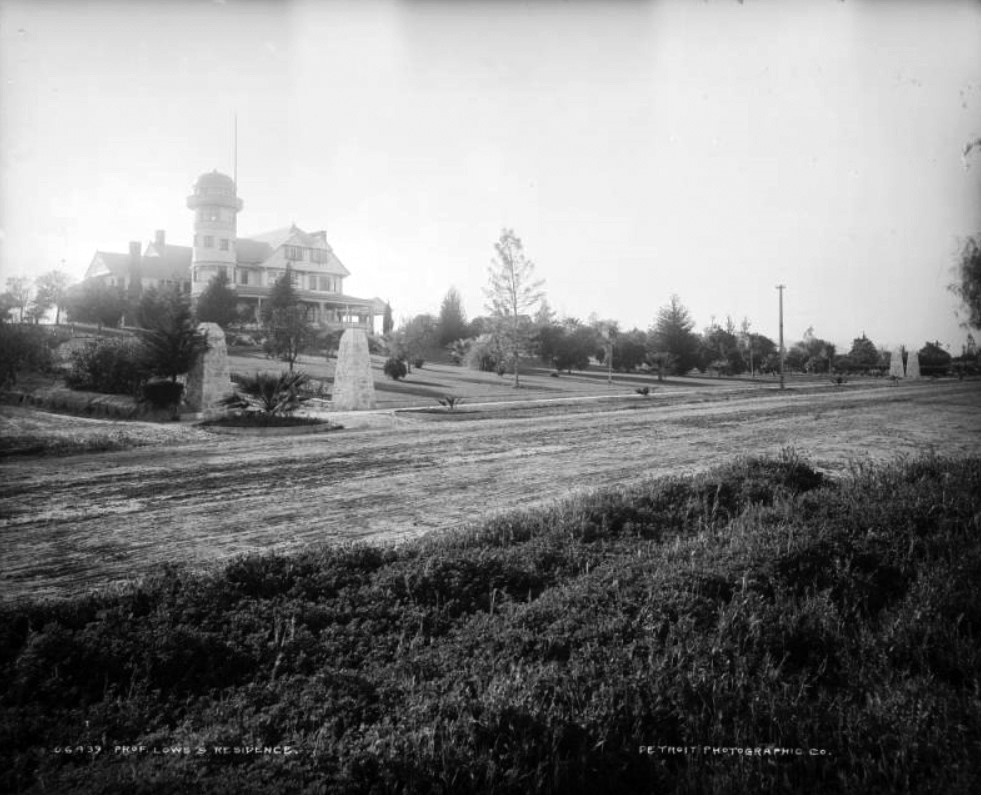
| (ca. 1890)*#*^ - View of Professor Thaddeus S.C. Lowe's home at 955 South Orange Grove in Pasadena. The multi-story stone and clapboard house has a multi-gabled roof, a large porch, dormers, chimneys, and an observatory within a domed tower. Stone entrance pillars and a manicured gardens front the house. |
 |
|
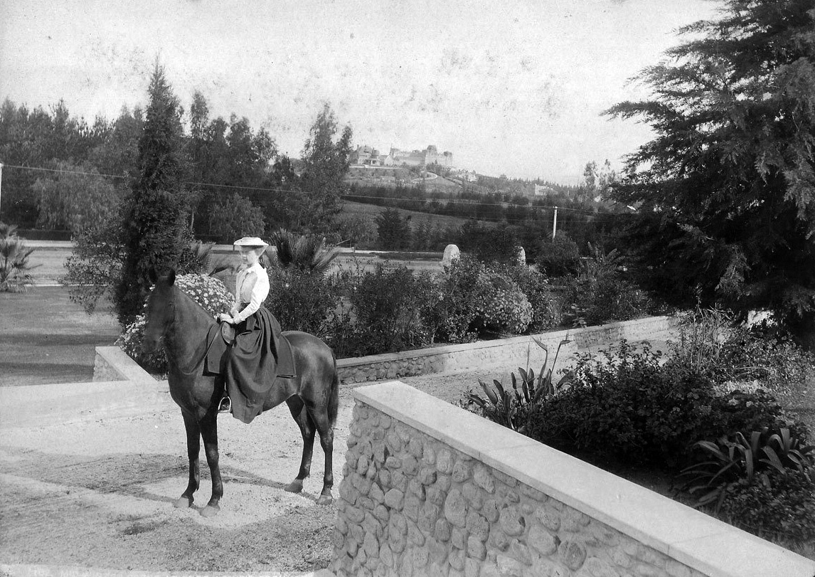
| (ca. 1890)++^ – View of a woman on horseback on the grounds of Professor T.S.C. Lowe's Pasadena Estate with the Raymond Hotel seen in the distance. |
 |
|
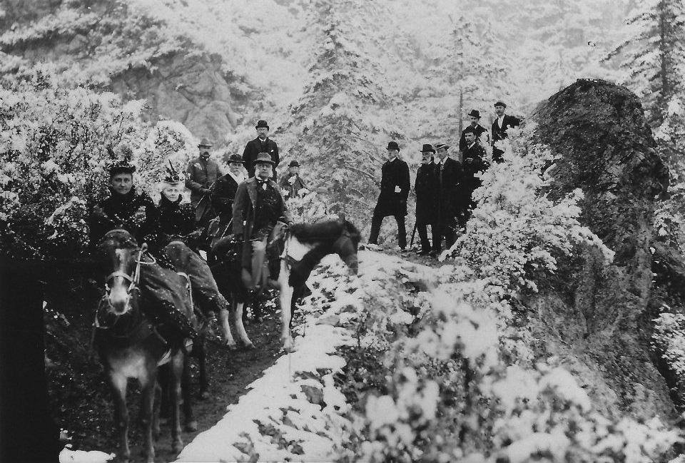
| (ca. 1893)* – View showing T.S.C. Lowe and party at Sphinx Rock in the San Gabriel Mountains. |
Historical Notes Professor Lowe loved giving tours, especially for visiting magnates. At left center, with bushy sideburns is Marshall Field, founder of the famous Chicago department store. Professor Lowe is just behind and to Field’s left in a derby. The older woman with the [under the circumstances] elaborate hat is Mr. Field’s wife Nannie. To the left of Nannie is one of Lowe’s many daughters, Edna. The man standing to the right of center with white papers in his coat pocket is the governor of California, H.H. Markham (1890-1894). Markham is the only California governor to come from Pasadena; Mount Markham is named for him. Beside the governor is Andrew McNally, the map king; his ornate Altadena mansion still stands at the corner of East Mariposa St. and Santa Rosa Avenue. ++# Thaddeus Lowe is best remembered for his Mount Lowe Railway which was placed on the National Register of Historic Places on January 6, 1993. The mountain itself still bears his name. Lowe is a member of the U.S. Army Military Intelligence Hall of Fame. Lowe Army Heliport at Fort Rucker, Alabama is named in his honor.*^ Click HERE to see more in Early Views of Mt. Lowe Railway. |
Painter Hotel (later La Pintoresca Hotel)
 |
|
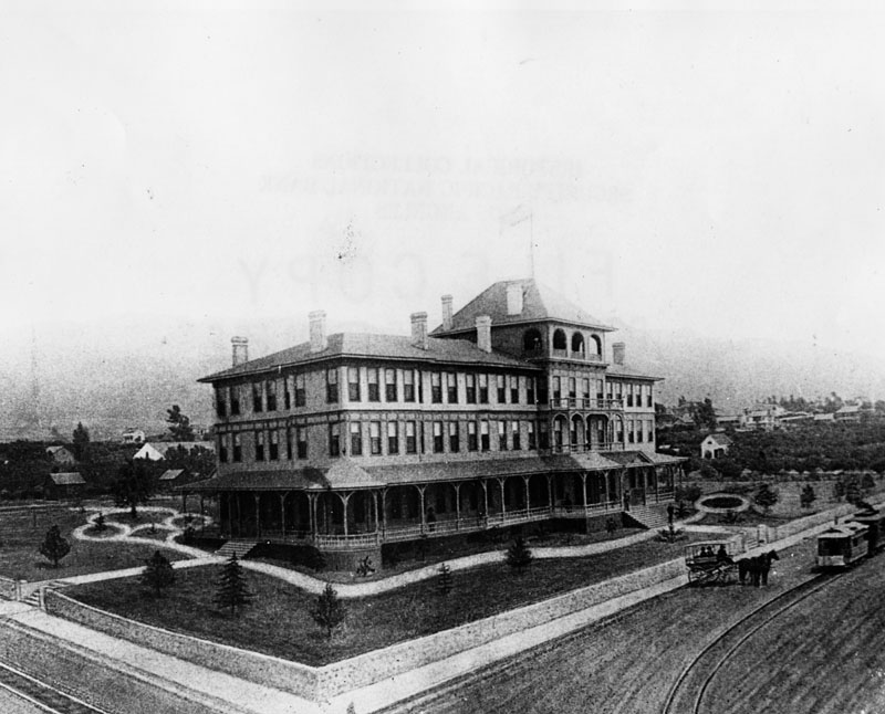
| (1888)* - View of the Painter Hotel located on the north side of Washington Street between Fair Oaks and Raymond. Built by J. H. Painter on land that he owned. |
Historical Notes The Painter Hotel opened Feb. 1888. It was the third largest hotel enterprise in Pasadena. The hotel was the distinguishing landmark of North Pasadena and is historical because of other large enterprises connected with it. |
 |
|
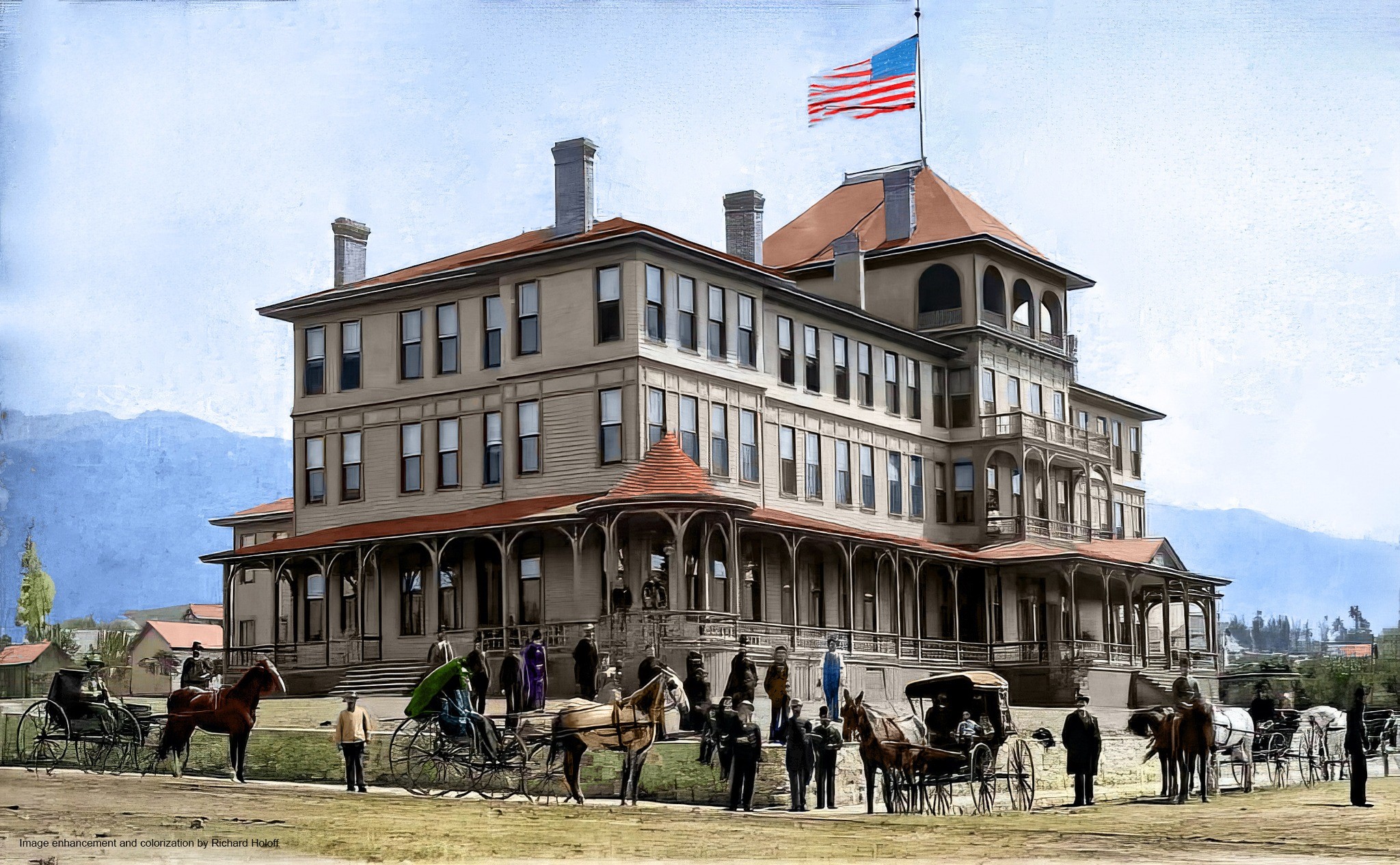
| (1888)* - View of the Painter Hotel located on the north side of Washington Street between Fair Oaks and Raymond. Built by J. H. Painter on land that he owned. Image enhancement and colorization by Richard Holoff |
 |
|
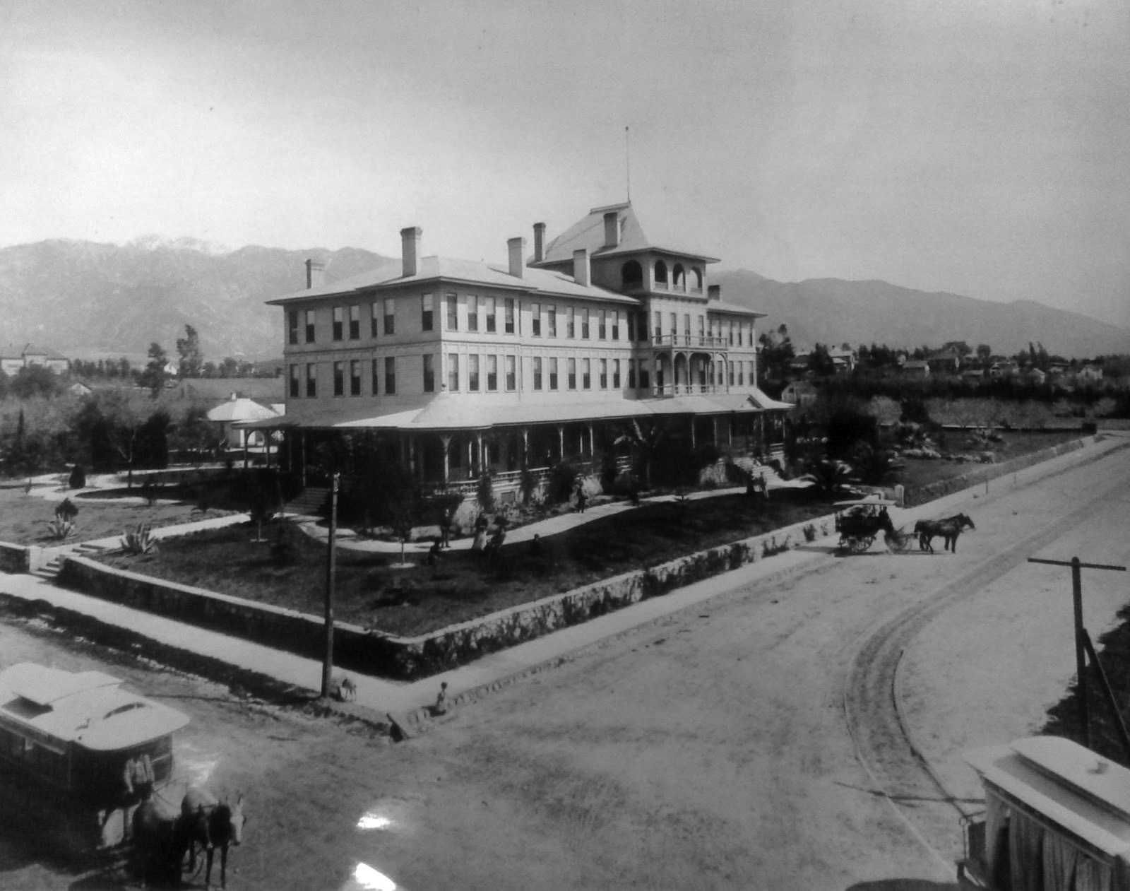
| (ca. 1890)* - Exterior view of the Painter Hotel. A horse-drawn carriage and trolley can be seen in front of the hotel on Washington Street. |
Historical Notes John Hunt Painter was a Quaker farmer living near Springdale, Iowa, who sent the firearms to abolitionist John Brown that were used during Brown's historic raid on Harpers Ferry in 1859. Painter was also an early settler of Pasadena where, in 1888, he erected the Painter Hotel (later La Pintoresca Hotel).*^ |
 |
|
| (ca. 1889)* - View showing the the Painter Hotel. A horse-drawn carriage is front of the hotel on Washington Street and two horse-drawn trolleys are seen in the foreground. |
 |
|
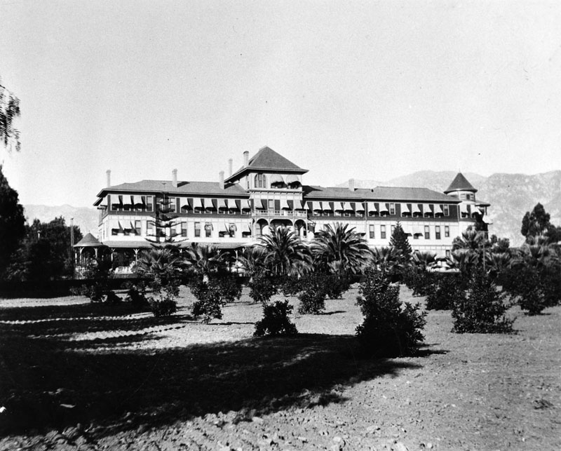
| (ca. 1890s)*- Exterior view of La Pintoresca Hotel (formerly Painter Hotel). Palm trees and an orchard can be seen on the grounds in front of the hotel. Note how the hotel has been enlarged (see previous photo). |
Historical Notes After the death of John Painter, the hotel was renamed La Pintoresca (1892). |
 |
|
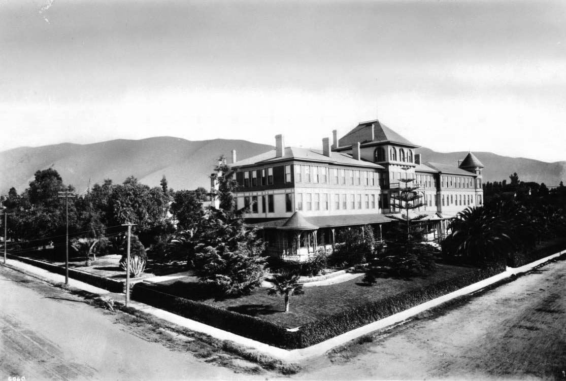
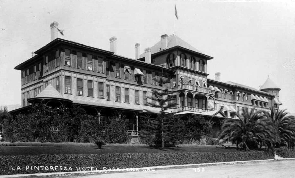
| (ca. 1895)* - View of the La Pintoresca Hotel, located on the northeast corner of Fair Oaks Avenue and Washington Street. The hotel stands at about four-stories tall. It features a conic-capped tower (at right), a conic-shaped corner (center), many windows and an immaculate yard. Trees, palms and bushes populate the yard. The San Gabriel Mountains are visible in the distance. |
Historical Notes "Pintoresca" is Spanish for the English word "picturesque". |
 |
|
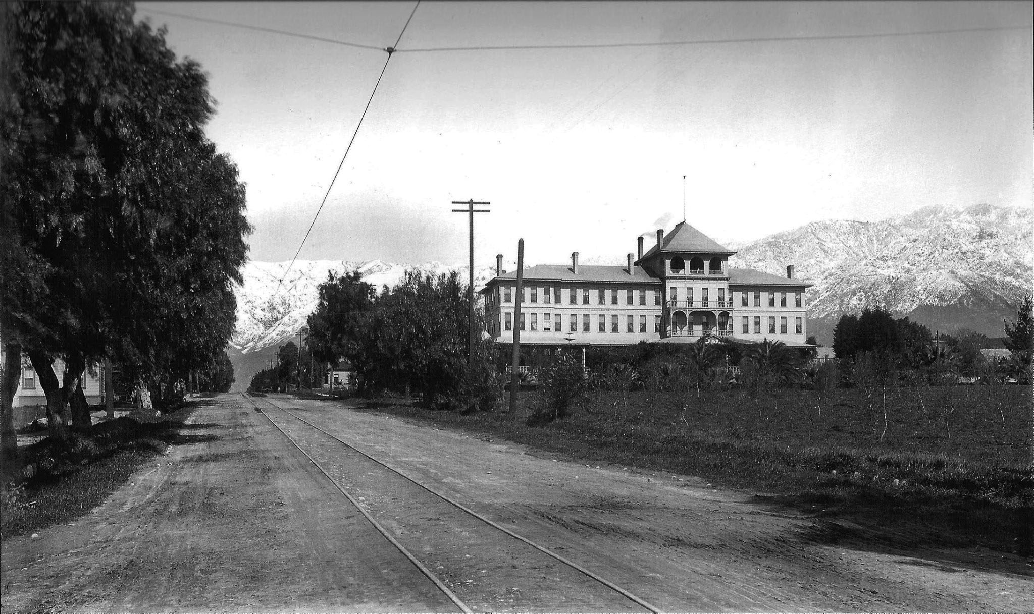
| (ca. 1890s)* – View looking north along Fair Oaks Avenue showing the La Pintoresca Hotel with the snow-covered San Gabriel Mountains in the background. You can barely make out Echo Mt. and Alpine Division ascending from it at right. |
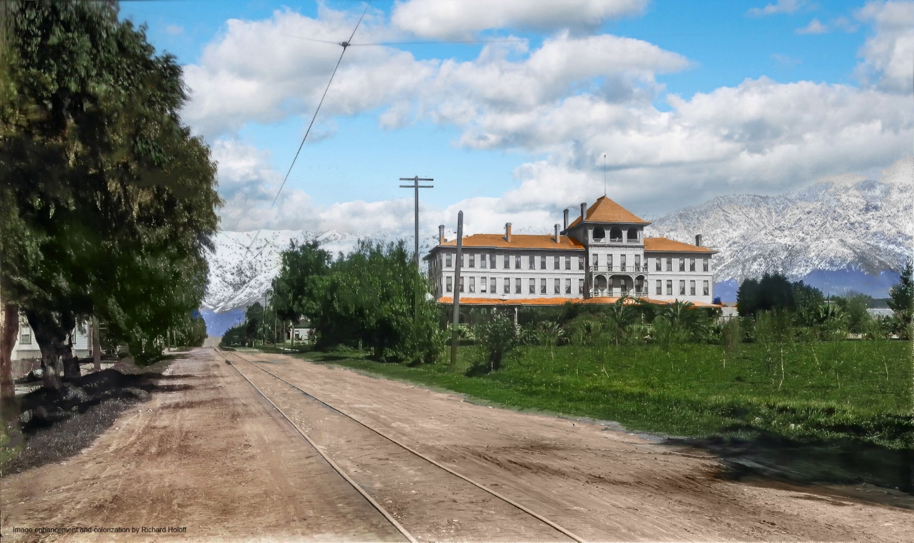 |
|
| (ca. 1890s)* – View looking north along Fair Oaks Avenue showing the La Pintoresca Hotel with the snow-covered San Gabriel Mountains in the background. You can barely make out Echo Mt. and Alpine Division ascending from it at right. Image enhancement and colorization by Richard Holoff |
 |
|
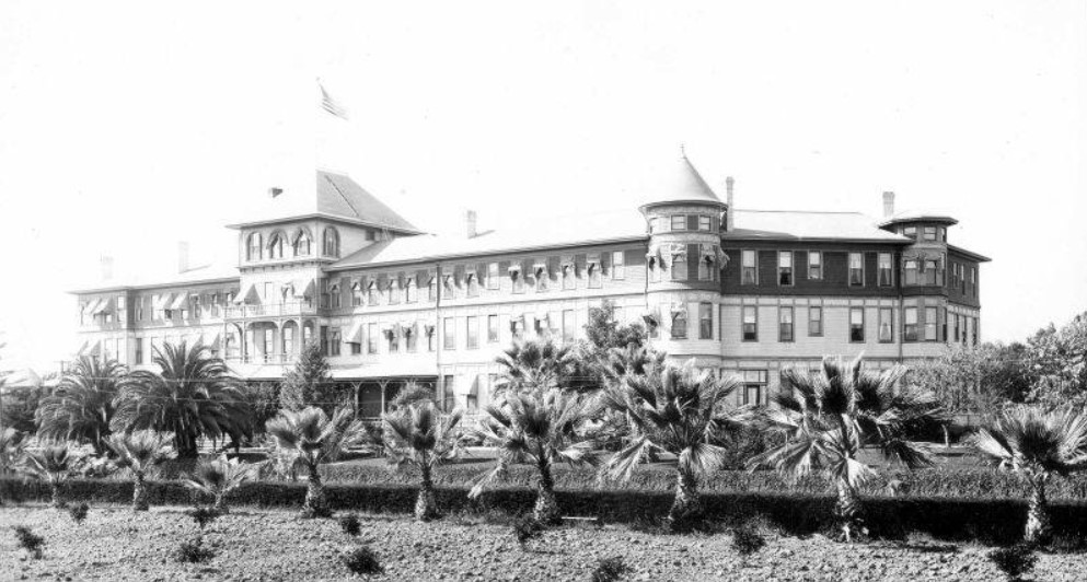
| (1897)* - Close-up view of the La Pintoresca Hotel showing a row of palm trees in front of the hotel. |
Historical Notes Over the years there were substantial additions to La Pintoresca Hotel, making it one of the largest hotels in Pasadena. |
 |
|
| (ca. 1910)* – Postcard view showing the La Pintoresca Hotel (formerly the Painter Hotel) on the corner of Fair Oaks Avenue and Washington Boulevard. This view shows the front facing onto Fair Oaks Avenue, with palm trees at the sidewalk and foliage around the porch. |
Historical Notes It was sold in 1905 and then destroyed by fire in 1912. Later, the City of Pasadena purchased the property and turned it into a park which it is today. * |
Early Pasadena Parades
 |
|
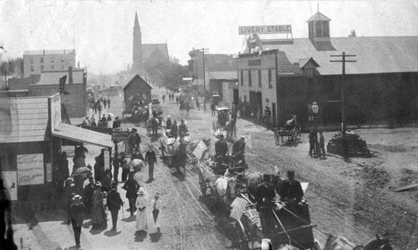
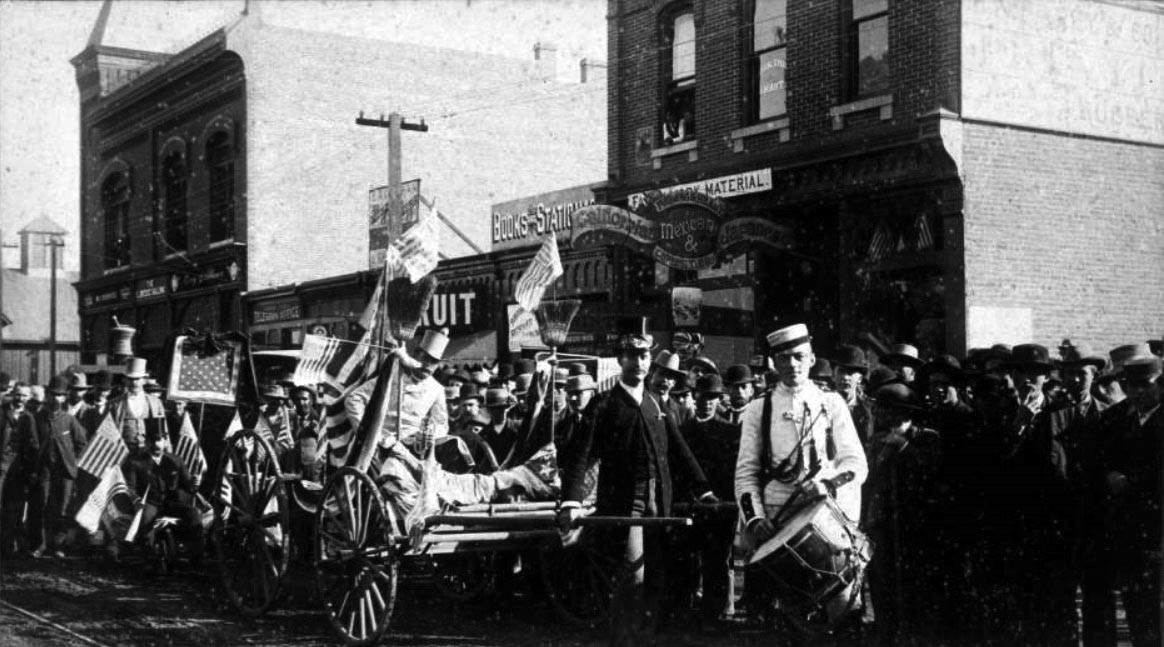
| (1888)* - A parade scene with spectators and American flags on Raymond Avenue, Pasadena. A drummer stands in uniform, and men in top hats are on a wagon draped with flags. The man at center holds a trumpet. Visible signs include "Telegraph Office" "Books and Stationery" "Musical Studio, J. Hart" (in upstairs window), "Furlong & Healy, Californian, Mexican and Japanese Curiosities." Photo Date: November 12, 1888 |
Historical Notes Title and date devised based on accompanying note that read: "Raymond Avenue. Nov. 12, 1888." This could possibly be related to an election, but the scene is not identified beyond the accompanying note. "Jarvis' Gallery, 29 E. Colorado St., Pasadena, Cal...."--text printed on verso. |
 |
|
| (1891)* - Decoration Day (now Memorial Day) parade in Pasadena, 1891. |
Historical Notes Memorial Day, which is observed every year on the last Monday of May, originated as Decoration Day after the American Civil War in 1868, when the Grand Army of the Republic, an organization of Union veterans founded in Decatur, Illinois, established it as a time for the nation to decorate the graves of the Union war dead with flowers. By the 20th century, competing Union and Confederate holiday traditions, celebrated on different days, had merged, and Memorial Day eventually extended to honor all Americans who died while in the military service. It marks the start of the unofficial summer vacation season, while Labor Day marks its end. The preferred name for the holiday gradually changed from "Decoration Day" to "Memorial Day," which was first used in 1882. Memorial Day did not become the more common name until after World War II, and was not declared the official name by Federal law until 1967. *^ |
 |
|
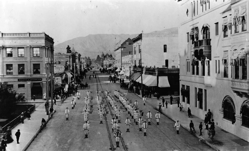
| (ca. 1890s)* - A flag-carrying marching group on Raymond Avenue, Pasadena, circa the 1890s. View is toward the north. William H. Staats Co. is on the left. |
Classical School for Boys
 |
|
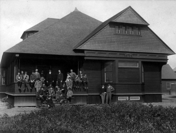
| (1891)** - View of a group of young men in front of the Classical School for Boys, located at 59 S. Euclid Ave. |
Historical Notes The Classical School for Boys opened in 1889 with a new building erected in 1891. Steven Cutter Clark, principal. |
Raymond Hotel (1st Raymond)
 |
|
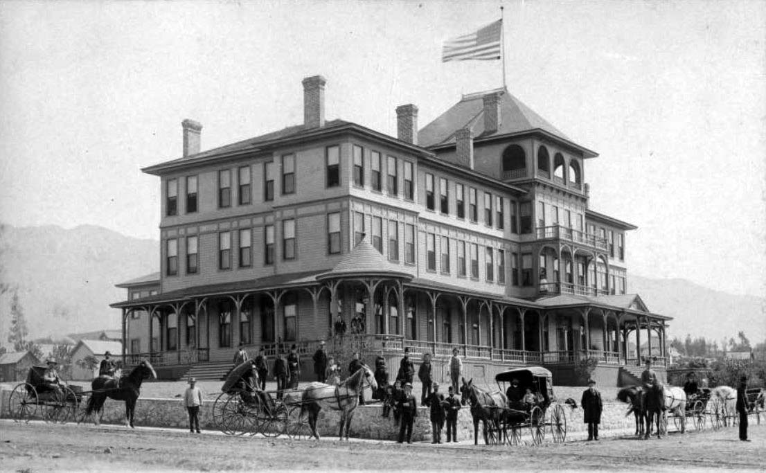
| (1895)* - View of the Raymond Hotel from its West Entrance. Wagon-wheel marks can be seen on the dirt road. |
Historical Notes The first Raymond Hotel in Pasadena was built by Mr. Walter Raymond of Raymond & Whitcomb Travel Agency of Boston, Massachusetts. It was a grand Victorian structure that opened on November 17, 1886, boasting 200 rooms and 80 chimney. Unfortunately, the original hotel burned down in 1895 but was rebuilt in 1901 with even more grandeur, featuring 400 rooms, golf links, and formal gardens. The hotel was a significant winter residence for wealthy Easterners and played a crucial role in transforming Pasadena into a popular destination for East Coast tourists seeking sunny skies and luxurious accommodations. |
 |
|
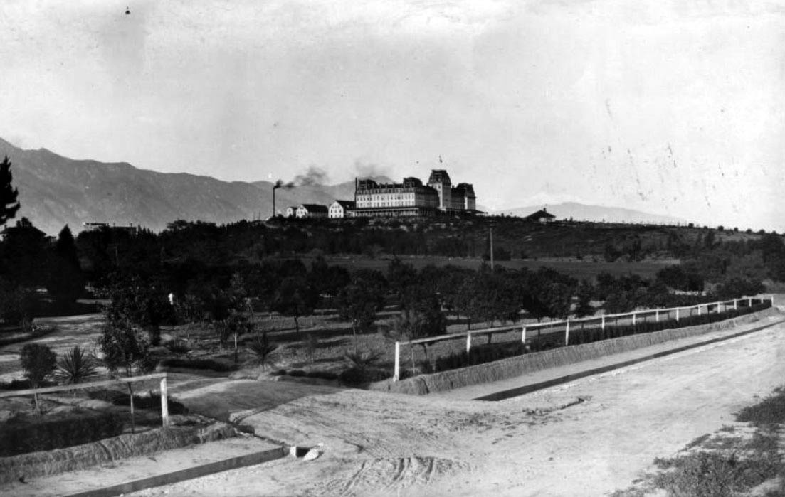
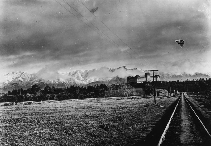
| (1894)* - The Raymond Hotel sits atop a hill and offers a view of the snow-covered San Gabriel Mountains that are partially obscured by clouds. Railroad tracks run from the foreground into the distance. Photo by C.C. Pierce |
Historical Notes The Raymond Hotel guests invariably arrived by train, the mainline Santa Fe which stopped at Raymond Station at the bottom of the hill. Many had private cars that would park on the side spur near the station. All guests were ferried by a horse-drawn bus to the hotel at the top of the hill. Later, much to the dismay of many guests, the old station closed down in deference to a newer station built up the tracks closer to downtown Pasadena. Guests were then forced to take an auto bus the extra distance to the hotel.* |
 |
|
| (1894)* - The Raymond Hotel sits atop a hill and offers a view of the snow-covered San Gabriel Mountains that are partially obscured by clouds. Railroad tracks run from the foreground into the distance. Photo by C.C. Pierce; Image enhancement and colorization by Richard Holoff |
 |
|
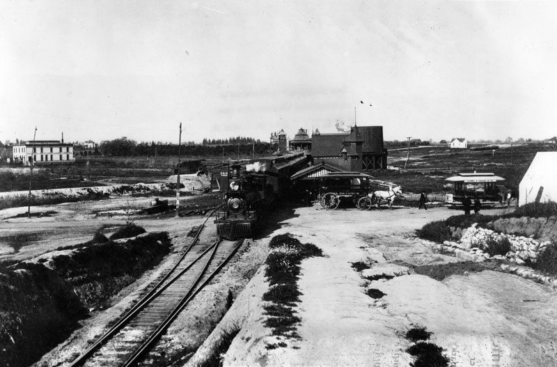
| (1890)* - Exterior view of the Raymond Station in South Pasadena. A locomotive with cars sits adjacent to the station, while a horse-drawn carriage and trolley stand ready to take passengers to the Raymond Hotel. |
 |
|
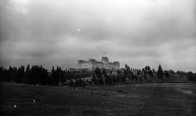
| (ca. 1890)* - View of the Raymond Hotel looking across the grounds at the western facade. Located in South Pasadena, it was the first major resort hotel of the San Gabriel Valley. |
Historical Notes There was a nine-hole golf course on a 50-acre lot alongside the hotel, and though it was humble in comparison, it was one of the few good attractions in the area. Much of the landscaping was done by the suggestion of the Mr. Theodore Payne, a famous local horticulturist of the time. The hotel also had card rooms, writing rooms, a reception room, and in the basement was a pool and billiards parlor — with a secret bar.* |
 |
|
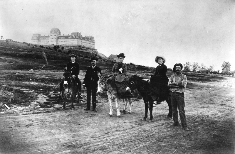
| (ca. 1890)* - Two women and a young man sit astride donkeys as they ride down the dirt road, accompanied by two men, that leads from the Raymond Hotel. The women sit side-saddle. |
.jpg) |
|
| (ca. 1890)* - View of the Raymond Hotel looking across the grounds at the western facade. A small building stands next to a path on the landscape grounds. Several horse-drawn carriages and stages are parked in front of the hotel. A portico runs around the building. |
 |
|
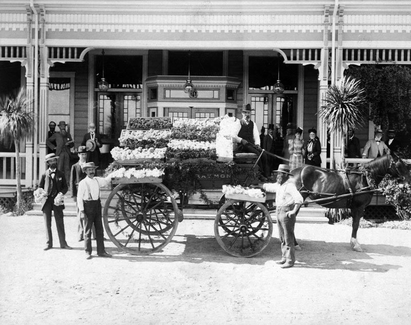
| (1890s)* - Long boxes of cut flowers lay on a horse-drawn cart with "The Raymond" printed on the side. The horse and driver have stopped at the entrance to the Raymond Hotel. Spectators watch the unloading from the shaded portico. |
Historical Notes The hotel had a large nursery operation with 500 American Beauty rose plants, 4 acres of carnations and a reported 3,000 pansies.* |
 |
|
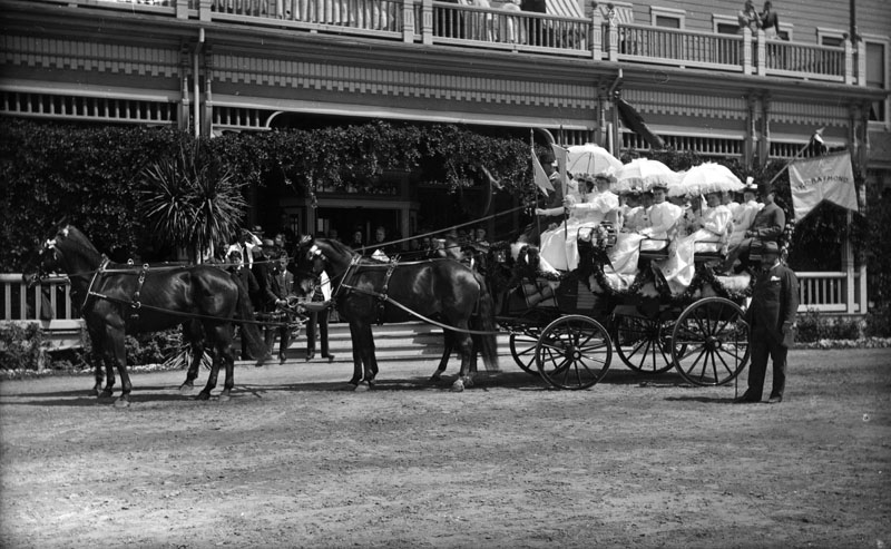
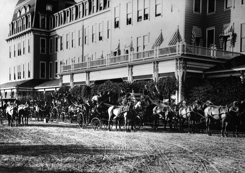
| (ca. 1890s)* - View of tally-ho in front of the Raymond Hotel in South Pasadena with Colonel Marshall C. Wentworth standing at right. |
 |
|
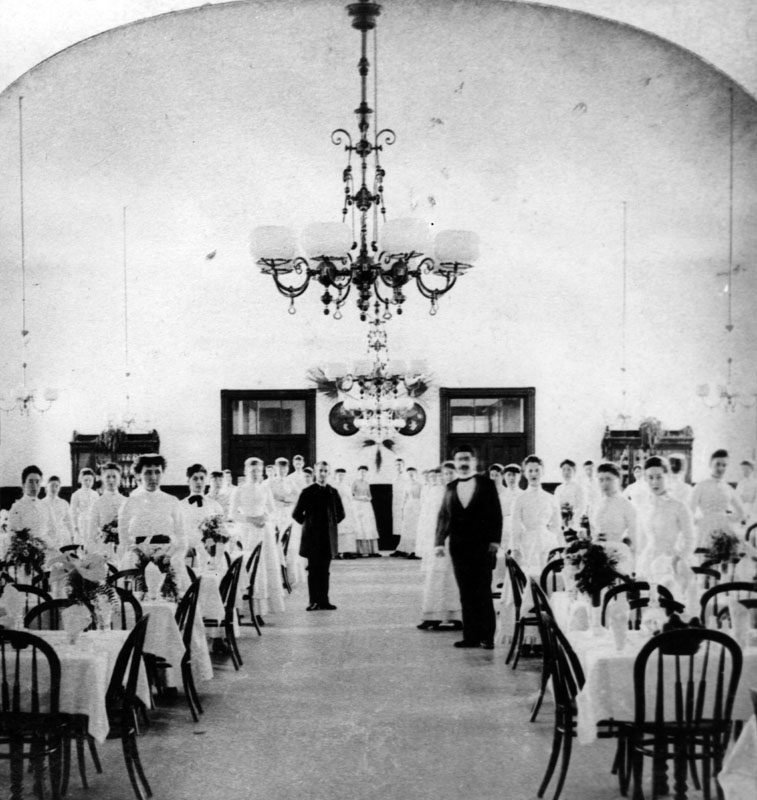
| (ca. 1890)* - The staff of the dining hall in the Raymond Hotel pose in their uniforms as they stand around the tables ready for the hotel's guests. |
Historical Notes The dining room was the largest room in the house able to seat 400 people. Pasadena City, which boasted of being a “dry” town, had an ordinance disallowing the sales of alcohol — except to the hotel guests.* |
 |
|
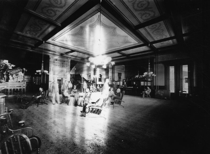
| (ca. 1890)* - A group of people sit under a hanging light fixture in the luxurious and spacious lobby of the Raymond Hotel. The beamed ceiling is decorated with painted motifs. An elevator is directly behind the seated group and large staircases behind the elevator and on both sides lead to the upper floors. The reception desk is to the left of the front doors. The floor is carpeted and spittoons stand close to several chairs. |
Historical Notes Part of the success of the Raymond was the transcontinental tours which came through the hotel. The tours were discontinued as the onslaught of newcomers repeatedly bothered the regular guests, who by now were a mainstay of the hotel.* |
 |
|
| (ca. 1890s)* - Mount Lowe - Tally Ho carriages parked in front of the Raymond Hotel, in Pasadena. Carriages take hotel guests to Mount Lowe and back. |
Historical Notes This is the original hotel built by Mr. Walter Raymond of Raymond & Whitcomb Travel Agency of Boston. It burnt to the ground in 1895 and was replaced by a second Raymond Hotel in 1903.* |
 |
|
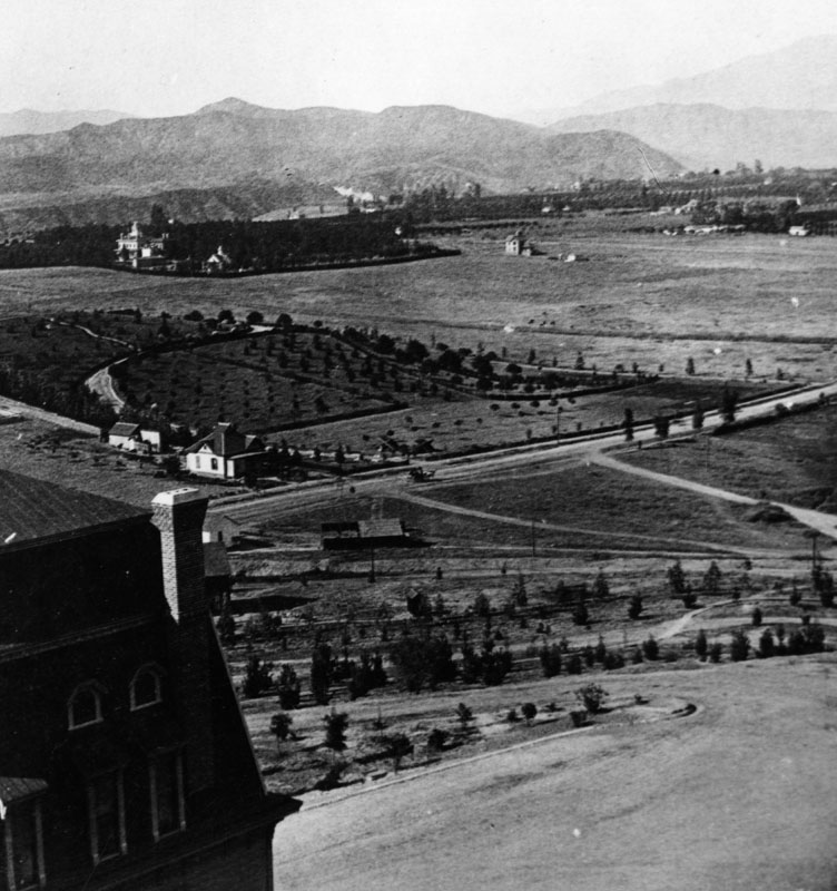
| (ca. 1890)* - View looking northeast from the Raymond Hotel showing the landscape between the hotel and the San Gabriel Mountains. |
 |
|
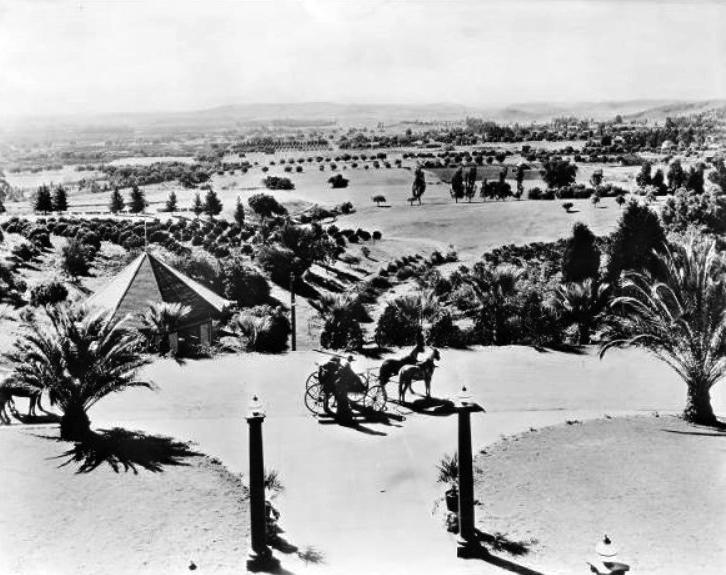
| (ca. 1890)#* - View looking south from the Raymond Hotel toward Oneanta Park. |
 |
|
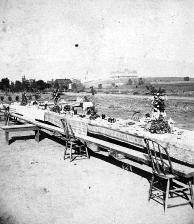
| (ca. 1890)* - View looking north showing a long picnic table set with decorative centerpieces and tablecloths in a field in South Pasadena, with the Raymond Hotel visible in the distance. |
Historical Notes The first Raymond Hotel was built in 1886 and burned down in 1895. A second Raymond Hotel would be built. It opened in 1901. |
 |
|
| (ca. 1890)^## – View looking southwest from the Raymond Hotel. |
 |
|
| (ca. 1890s)* - View of orange groves looking west from the Raymond Hotel. |
 |
|
| (ca. 1890)* - View taken from the Raymond Hotel in Pasadena shows residential homes and cultivated land. Snow on the Sierra Madre's can be seen in the background. |
 |
|
| (1890)* - View of Pasadena residential area looking south from the M. E. Church. In the far distance can be seen the Raymond Hotel perched on Bacon Hill. |
Mt. Lowe
.jpg) |
|
| (ca. 1890)* - Postcard view showing Pasadena and Mount Lowe taken from the Raymond Hotel. |
 |
|
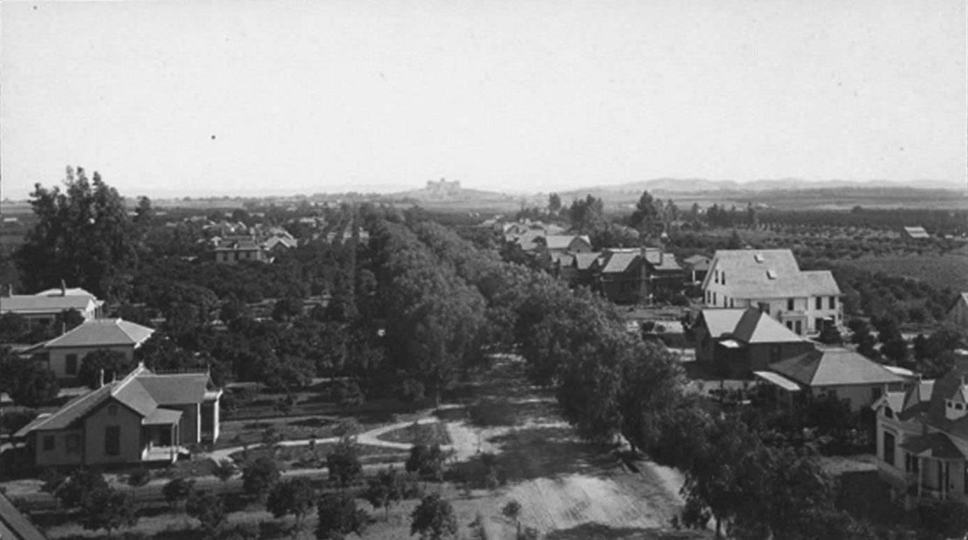
| (ca. 1893)^^ - Panoramic view of Pasadena, looking northeast from the La Pintoresca Hotel. Houses and trees are sparsely scattered across the landscape. Mt. Lowe and Echo Mountain are in the center of the range. |
 |
|
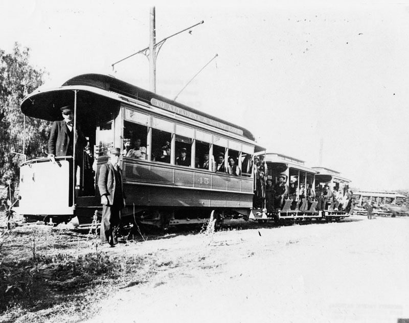
| (ca. 1890s)* - View of three streetcars full of travelers on their way to Altadena with continuing service to Mount Lowe, as indicated on the top car streetcar #45 on the left. Visiting Mount Lowe in the San Gabriel Mountains was a "must" for the local inhabitants as well as tourists. The journey started at Mountain Junction in Altadena, moved by electric car (such as shown here) to Rubio Pavilion, the bottom terminus of the Cable Incline Railway. This photograph was taken at Lake Avenue and Mariposa in Altadena. |
Click HERE to see more in Early Views of Mt. Lowe Railway |
South Pasadena
 |
|
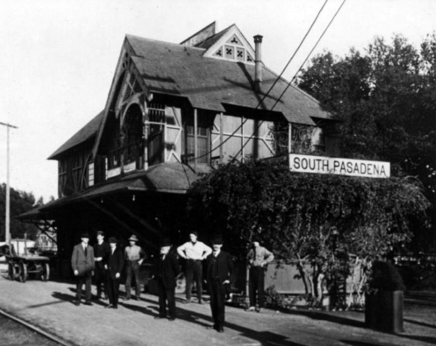
| (ca. 1890)^#^^ – View showing eight men posing in front of the Santa Fe Railroad Station in South Pasadena. |
 |
|
| (ca. 1890)^#^^ – Panoramic view of South Pasadena showing houses and farms. |
Historical Notes In February 1888, members of the southern portion of Pasadena attempted to gain more control over their own property and a vote for incorporation was made. In 1888, South Pasadena incorporated the southern portion of the Indiana Colony and land south and eastward to the Los Angeles border.*^ |
 |
|
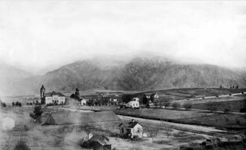
| (ca. 1893)^#^^ – View of South Pasadena from the Monterey Hills. The Raymond Hotel can be seen on top of Bacon Hill. In the background and beyond is the City of Pasadena and the San Grabriel Mountains. |
Historical Notes On March 2, 1888, the city of South Pasadena was incorporated with a population slightly over 500 residents, becoming the sixth municipality in Los Angeles County. It was chartered with roughly the same area as the current South Pasadena, about 3.42 square miles. With completion of the Pacific Electric Short Line, putting the entire city within easy walking distance of the “red car” stations, South Pasadena also became a one of the first suburbs of Los Angeles. South Pasadena is associated with that of the Cawston Ostrich Farm and the Fair Oaks Pharmacy and Soda Fountain as they played vital roles in the history of the city.*^ |
 |
|
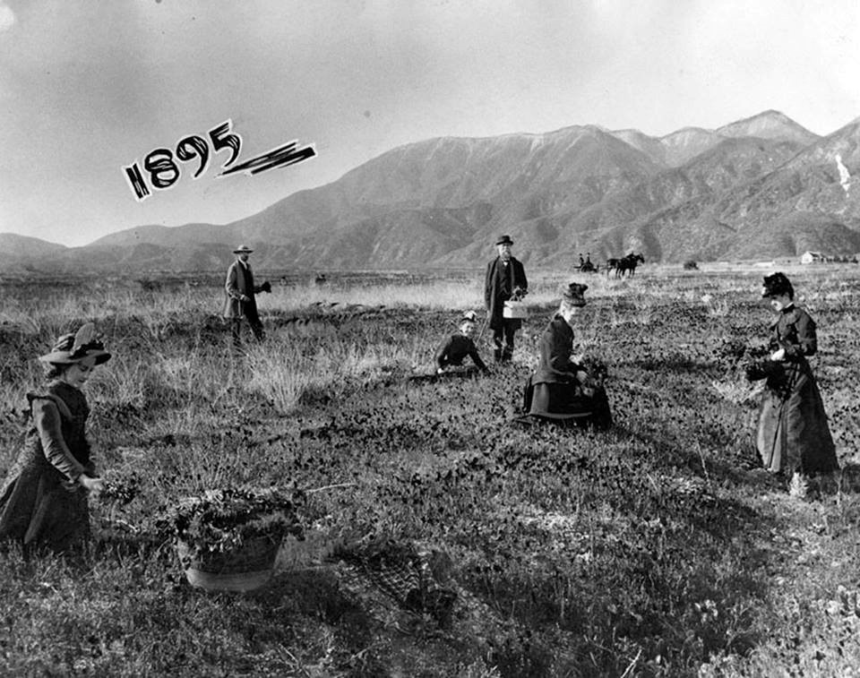
| (1895)^#^^ – View of South Pasadena from the Monterey Hills showing the rich farmland. |
_1895.jpg) |
|
| (1895)^#^^ – View of South Pasadena from the Monterey Hills. In the distance can be seen the Rayomond Hotel, the City of Pasadena, and the majestic San Gabriel Mountains. |
Altadena
 |
|
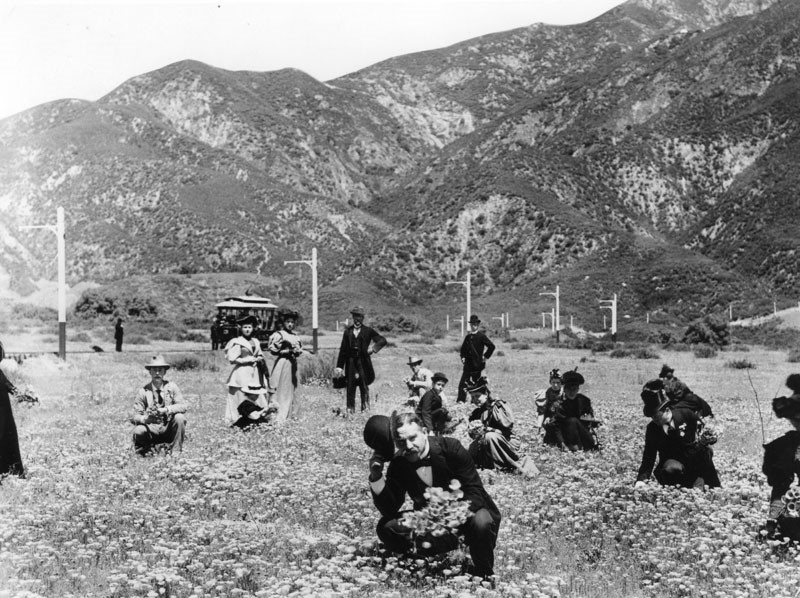
| (ca. 1895)* - A group of people picking California poppies growing naturally near north Lake Avenue in Altadena. The Mount Lowe Railroad electric car is parked nearby, and the poles lead north to the end of Lake Avenue and turn right. |
Historical Notes Altadena has always been popular for its colorful poppy fields, and before the turn of the century it was even more popular, for the sailors on ships coming into coast harbors could see the "flaming" fields from far off, and often used them as navigation aids. There were always enough for folks to pick, too.* |
 |
|
| (1895)* - View showing a group of people picking flowers in a poppy field about the spot where Lake Avenue now meets Woodbury Road. |
* * * * * |
Please Support Our CauseWater and Power Associates, Inc. is a non-profit, public service organization dedicated to preserving historical records and photos. Your generosity allows us to continue to disseminate knowledge of the rich and diverse multicultural history of the greater Los Angeles area; to serve as a resource of historical information; and to assist in the preservation of the city's historic records.
|
More Historical Early Views
Newest Additions
Early LA Buildings and City Views
History of Water and Electricity in Los Angeles
* * * * * |
References and Credits
* LA Public Library Image Archive
^*California Historic Landmark Listing (Los Angeles)
#* Huntington Digital Library Archive
#+ East of Allen blogspot: Sierra Madre Villa; William Cogswell, Famous Artist and East Pasadena Pioneer
#*^Flu Pandemic of 1918: www.flu.gov
*^^Nuestra Señora la Reina de los Ángeles: losangelespast.com
*#*KCET: When L.A.'s Most Famous Streets Were Dirt Roads; Scoville Bridge; The Raymond Hotel
*#^First United Methodist Church of Pasadena
^*#Noirish Los Angeles - forum.skyscraperpage.com; First Church; Raymond Hotel
^##California State Library Image Archive
###Library of Congress: Raymond Hotel Parnoramic, ca.1908; Hotel Green Panoramic, ca. 1908
#++Bridgehunter.com: Scoville Bridge; Colorado Bridge
*++Christmas Tree Lane Association
++^Professor Thaddeus Lowe- Mount Lowe Railway
^**^The Grand Opera House – by Jake Brouwer
*#*^Denver Public Library Image Archive
*#*#Downtown Pasadena's Early Architecture
^#^^Calisphere: University of California Image Archive
*##*The Development of Pasadena and Washington Square: washingtonsquarepasadena.org
#*^*Hometown Pasadena: Pasadena's Abolitionist Heritage
#^**Eventbrite.com: Altadena Historical Society Tour of Col. G. G. Green's Carriage House
*^ Wikipedia: History of Pasadena; Tournament of Roses Parade; The Langham Huntington; Hotel Green; Rose Bowl Game; Pasadena City Hall; Old Town Pasadena; Los Angeles Terminal Railway; Richard H. Chambers United States Court of Appeals and the Vista del Arroyo Hotel and Bungalows; California Institute of Technology; Benjamin Wilson; Raymond Hotel; Fair Oaks Avenue; South Pasadena; Andrew McNally; McNally Residence; Owen Brown (Abolitionist); Altadena; John Hunt Painter; Los Angeles and San Gabriel Railroad
< Back