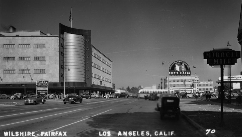
Early Views of Wilshire and Fairfax
Historical Photos of Wilshire and Fairfax |
 |
|
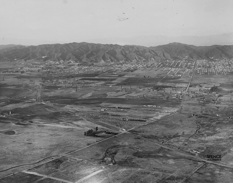
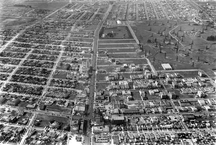
| (1922)^ - Aerial view looking northwesterly showing Crescent Ave (later Fairfax Ave) running diagonally from lower-left to center-right where it crosses Wilshire Boulevard (center-right) and makes a slight bend north towards the Hollywood Hills. San Vicente runs diagonally from lower-right to upper left and turns up toward West Hollywood. Note the oil wells scattered across the open land. |
Historical Notes In the early 1920s, the stretch of Wilshire Boulevard now known as the Miracle Mile was a 20-foot-wide dirt road, flanked by oil wells and barley fields. Today, the strip is a busy thoroughfare, home to museums, the La Brea Tar Pits, and a collection of historic Art Deco structures. |
Wilshire and Fairfax
 |
|
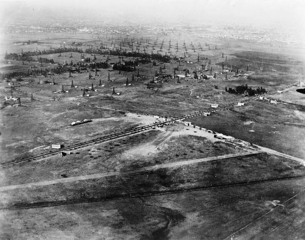
| (1920)^ - Aerial view of Crescent Avenue (now Fairfax) and Wilshire Boulevard in 1920 showing undeveloped land with many oil derricks. In the lower part of the photograph is Chaplin Airport. The tree-lined street is Wilshire. The diagonal line at the bottom is actually railroad tracks that would later become San Vicente Bouelvard. |
Historical Notes The Fairfax District was little more than bean fields at the turn of the century when Arthur Fremont Gilmore set out to dig a well on his 256-acre dairy farm near West 3rd Street in Fairfax Avenue. But instead of water, Gilmore struck oil. His discovery is credited with prompting an oil exploration boom in the area- later called the Salt Lake oil fields. Gilmore helped build the Fairfax area into one of the city’s best-known commercial areas (Farmers Market).+# |
 |
|
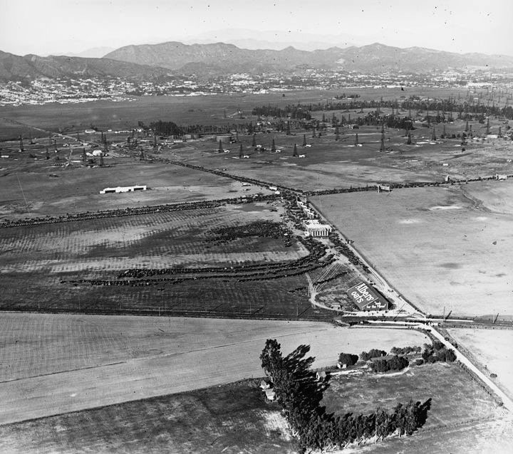
| (ca. 1922)^##* - View looking north shows numerous cars parked on a lot (center of photo) near the airfield as well as along Wilshire Blvd. and Crescent Ave (Fairfax). Large sign on building in the lower-right center at the intersection of Fairfax and the San Vicente line of the Pacific Electric Railway reads: Albers Oats. |
Historical Notes In the 1890s, dairy farmer Arthur F. Gilmore found oil on his land, probably in the vicinity of the La Brea Tar Pits. The field was named after the Salt Lake Oil Company, the first firm to arrive to drill in the area. The discovery well was spudded (started) in 1902. Development of the field was fast, as oil wells spread across the landscape, with drillers hoping to match the production boom taking place a few miles to the east at the Los Angeles City field. Peak production was in 1908. By 1912, there were 326 wells, 47 of which had already been abandoned, and by 1917 more than 450, which had by then produced more than 50 million barrels of oil. After this peak, production declined rapidly. Land values rose, corresponding to the fast growth of the adjacent city of Los Angeles, and the field was mostly idled in favor of housing and commercial development. The early wells were abandoned; many of their exact locations are not known, and are now covered with buildings and roads.^* |
 |
|
| (ca. 1922)^.^ – Aerial view looking down at the Chaplin Airdrome with the intersection of Crescent Avenue(later renamed Fairfax) and Wilshire Boulevard seen in upper-left. |
Historical Notes Chaplin Airfield was located on leased property that is now bounded by Wilshire Boulevard, Fairfax Avenue, and San Vincente Boulevard. The Syd Chaplin Aircraft Corporation advertised that it “maintained a fleet of newest Curtis one and two-passenger aeroplanes, large shops with complete equipment and hangars for our own ships as well as those belonging to business firms and individuals.” Syd Chaplin was the brother of famed actor Charlie Chaplin. |
 |
|
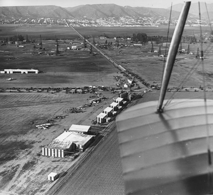
| (ca. 1922)^#^# - View looking north over the wing of a bi-plane showing the intersection of Crescent Ave (Fairfax) and Wilshire Blvd. A crowded airfield (now Rogers Airfield) is seen below. In the distance oil derricks are seen at Fairfax Avenue where 6th Street is located today. In the far background, at the foothills, can be seen a built-up Hollywood. |
Historical Notes By 1922 both Chaplin Airfield (S/W corner) and De Mille Field No. 2 (N/W corner) would be owned by Emery H. Rogers, owner of Rogers Aircraft Inc. They would be part of Rogers Airfield which straddled Wislhire Boulevard west of Farifax Avenue. Click HERE to see more in Aviation in Early Los Angels. |
 |
|
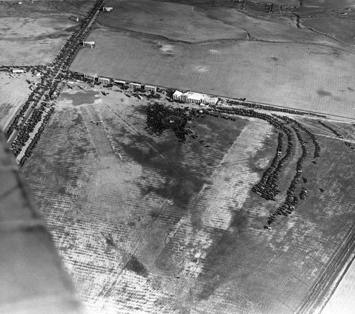
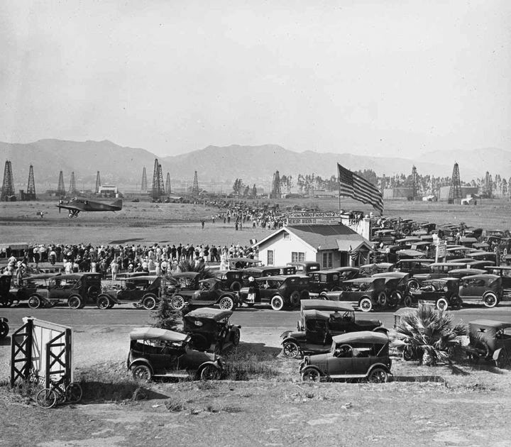
| (1920s)^#^# - Parking lot is full as crowds attend air show at DeMille Field No. 2. The sign on top of the structure with the large American Flag reads: DeMille Field No. 2. View is looking northeast near the NW corner of Wilshire and Fairfax. In the background can be seen oil derricks and on the right (out of view) are the La Brea Tar Pits. |
 |
|
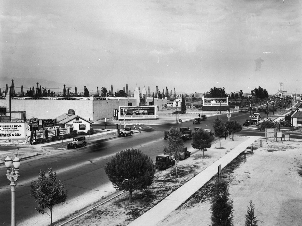
| (ca. 1929)*# - View looking east on Wilshire Boulevard toward its intersection with Fairfax Avenue. The northeast corner with the billboard is where the May Company Department Store would go about 10 years later. On the opposite corner (NW corner) where the little white house is, was once Rogers Airport, and would later become the iconic circular Simon's Drive-in restaurant. It is now the Johnies 50s diner. Oil wells are spread out where Park La Brea is now. |
Historical Notes In the late 1930s the 1.5-mile stretch of Wilshire Boulevard between Fairfax and Highland Avenues would be named the Miracle Mile. |
 |
|
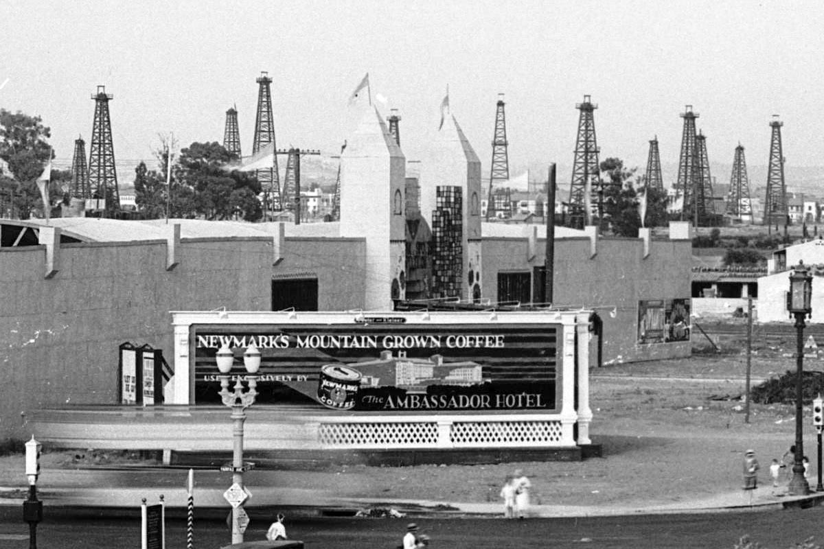
| (ca. 1929)*# – Close-up view of the northeast corner of Wilshire and Fairfax with an unusual shaped building located at the future site of the May Company Building. Signboard in the foreground reads “Newmark’s Mountain Grown Coffee Exclusively Served by the Ambassador Hotel”. Note all the oil derricks in the background. |
 |
|
| (ca. 1929)* - Two towers mark the entrance to this walled structure on the NE corner of Fairfax Avenue and Wilshire Boulevard. The sign above the entrance may include the words "Sports Town." |
 |
|
| (1930)^ - Aerial view looking west down Wilshire Boulevard from above Sycamore. The widest street visible, Wilshire, became known as the Miracle Mile, where most high rises were built through the years. The Salt Lake Oil Field is at upper-right and the La Brea Tar Pits at upper-center. Fairfax runs horizontal at top of photo at the end of the oil field. Farmers Market is out of view in the upper-right. |
Historical Notes Developer A.W. Ross foresaw a grand commercial destiny for western Wilshire Boulevard earlier than anyone else. In the early 1920s, Ross began buying up land along Wilshire Boulevard between La Brea Avenue and Fairfax Avenue, a pursuit some referred to as “Ross’s Folly.” He envisioned a destination shopping district that would lure customers from Beverly Hills as well as Hollywood and downtown Los Angeles, and encouraged the construction of architecturally distinctive commercial buildings. Ross’s development gamble along the western part of Wilshire Boulevard paid off in spades from the late 1920s and through the 1930s, as “Ross’s Folly” became known as Miracle Mile. The area housed large retailers like Desmond’s, Silverwoods, and the May Company, and even supermarkets like Ralph’s boasted flashy architecture on a grand scale. Ross remained a major force in the development of Wilshire Boulevard until the 1960s, seeing the boulevard lure the city’s population ever westward. |
Click HERE to see more Early Views of the Miracle Mile (1940s & 1950s). |
 |
|
| (1938)^^ – View looking NW showing the intersection of Wilshire and Fairfax with Simon’s Drive In Cafe seen on the left (NW corner). The following year construction would begin on the May Company on the lot with the billboard (NE corner). |
 |
|
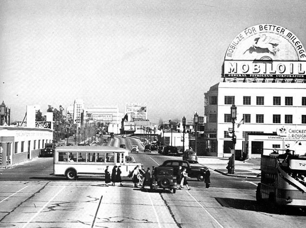
| (1938)^^ – View looking east on Wilshire Boulevard at Fairfax Avenue. At right is a double-decker bus on the Los Angeles Motor Coach Wilshire Line and crossing Wilshire is a bus on the Fairfax Avenue line. The building on the right with the rooftop Mobil Gas billboard is the 6030 Wilshire building (later the location of the A+D Museum). On the left (NE corner) can be seen what appears to be a single story building but is really a facade in front of the construrction site for the new May Compnay Building (Completed in 1940). |
.jpg) |
|
| (1939)**^ - View looking toward the northeast corner of Wishire and Fairfax in the early stages of construction for the Wilshire May Company Building. Simon's Drive-in is seen on the northwest corner. |
 |
|
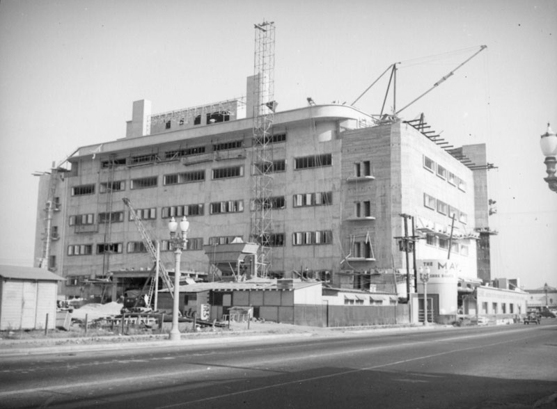
| (1939)* - View looking across Fairfax Avenue toward the northeast corner of Fairfax and Wilshire showing cranes and scaffolding surrounding the Wilshire May Company store still under construction. |
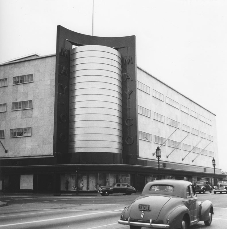
Historical Notes Albert C. Martin and Samuel A. Marx designed the 1939 Streamline Moderne style May Company department store, located at 6067 Wilshire Boulevard.* Martin also designed the Million Dollar Theatre and Los Angeles City Hall. |
.jpg) |
|
| (1940)##**– Aerial view showing the May Company Department Store, NE corner of Wishire and Fairfax, shortly after its opening. Across Fairfax (NW corner) can be seen the popular Simon's Drive-in restaurant where the Googie-influenced Johnie's Coffee Shop now stands. |
 |
|
| (ca. 1940)* - Exterior view of the May Co. Department Store, located on the northeast corner of Wilshire and Fairfax. A man appears to be standing on top of the May Co. sign. A sign for Simon's Sandwiches can be seen at lower-left (NW corner). |
Historical Notes When it opened, the gleaming May Company building was instantly heralded as the western gateway to the Miracle Mile, beckoning to motorists with an enormous gold-tiled cylinder at the corner of Fairfax Avenue. |
 |
|
| (1940s)**^ - View looking toward the northeast corner of Wilshire and Fairfax where the beautiful May Company Department Store Building stands. |
Historical Notes May Company California was established in 1923 when May acquired A. Hamburger & Sons Co.(founded in 1881 by Asher Hamburger). The company operated exclusively in Southern California until 1989 when May Department Stores had dissolved Goldwater's, based in Scottsdale, Arizona and transferred its Las Vegas, Nevada store to May Company California.*^ |
 |
|
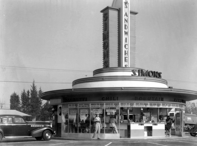
| (1939)*# - View showing Simon's Drive-in Restaurant on the northwest corner of Fairfax Avenue and Wilshire Boulevard. This is an engineering notebook photoprint taken from top deck of Wilshire Boulevard Bus. |
Historical Notes Simon's Drive-in Restaurant was built in 1935 and looks very similar to many of the other drive-ins built in the 1930s. That's because so many of these futuristic looking drive-ins were designed by architect Wayne McAllister. Wayne McAllister was a Los Angeles-based architect who was a leader in the Googie style of architecture that embraced the automobile and the Space Age. Inspired by tail fins and gleaming chrome, he elevated the drive-in restaurant to futuristic works of art. He created iconic circular drive-in restaurants in Southern California, including Simon's, Herbert's, Robert's, and McDonnell's in the 1930s. |
 |
|
| (1939)^ - A daytime view of Simon's Drive-in Restaurant located on the northwest corner of Fairfax and Wilshire. Through the glass floor-to-ceiling windows, patrons can be seen sitting at the circular counter having their meals. "Spaghetti", "Chili", "Fountain", "Hamburgers" and "Barbecue" can be seen above the windows. A carhop is standing at front, holding food in her hand. |
Historical Notes At one time Simon's Drive-ins dominated the Southern California drive-in restaurant craze. The Simon brothers had operated a chain of successful dairy lunch counters in downtown Los Angeles, and in 1935 decided to capitalize on the growing car culture of Los Angeles by opening auto friendly locations in the emerging commercial centers of Wilshire Boulevard, Sunset and Ventura Boulevards. Click HERE to see more Early LA Drive-in Restaurants. |
 |
|
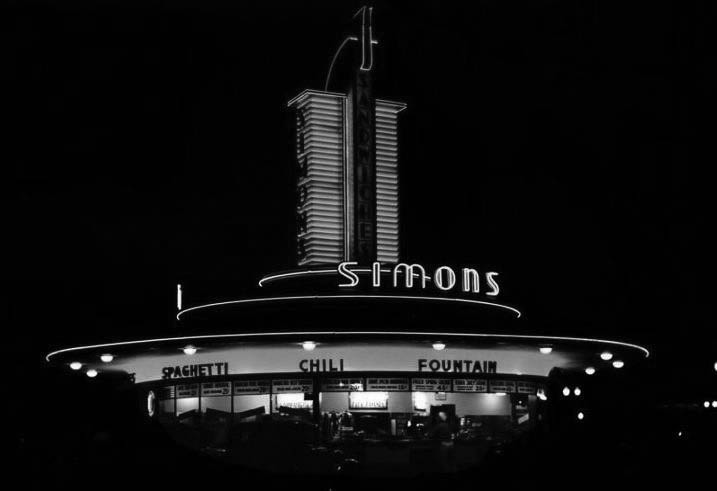
| (ca. 1940s)##** - Night view showing the neon-lit Simon's Drive-in Restaurant at Fairfax and Wilshire, NW corner. |
Historical Notes This is the same corner where the 1950s Johnie's Coffee Shop now stands. Across the street is the old May Company department store building which is now a part of LACMA/the Hollywood Museum. Going back further to the early 1900s, this is where the Chaplin Airfield was once located (Click HERE to see more in Aviation in Early L.A.). |
 |
|
| (1947)^ - Postcard view of the beginning of the Miracle Mile, at Fairfax and Wilshire, with the May Company Building prominently seen in the background. A large sign for Simon's Drive-in Restaurant can be see at left on the NE corner. |
Historical Notes A. W. Ross saw potential for the area and developed Wilshire as a commercial district to rival downtown Los Angeles. Ross's insight was that the form and scale of his Wilshire strip should attract and serve automobile traffic rather than pedestrian shoppers. He applied this design both to the street itself and to the buildings lining it. |
 |
|
| (1948)*# - View of the Miracle Mile and the May Company Building, looking east down Wilshire Boulevard. Different styles of streetlights run up and down Wilshire Boulevard. Click HERE to see more in Early Los Angeles Street Lights. |
Historical Notes The Miracle Mile development was initially anchored by the May Company Department Store with its landmark 1939 Streamline Moderne building on the west and the E. Clem Wilson Building on the east, then Los Angeles's tallest commercial building. |
 |
|
| (1940s)^ - View looking at the intersection of Fairfax Avenue and Wilshire Boulevard. The May Company Building can be seen on the northeast corner. |
Historical Notes The May Company Building has a Streamline Modern style with gold corner towers. Built in 1940. Architects: A.C. Martin, S.A. Marx. In 1992, the building was designated LA Historic-Cultural Monument No. 566 (Click HERE to see complete listing). May Company California was established in 1923 when May acquired A. Hamburger & Sons Co.(founded in 1881 by Asher Hamburger). The company operated exclusively in Southern California until 1989 when May Department Stores had dissolved Goldwater's, based in Scottsdale, Arizona and transferred its Las Vegas, Nevada store to May Company California.^* |
 |
|
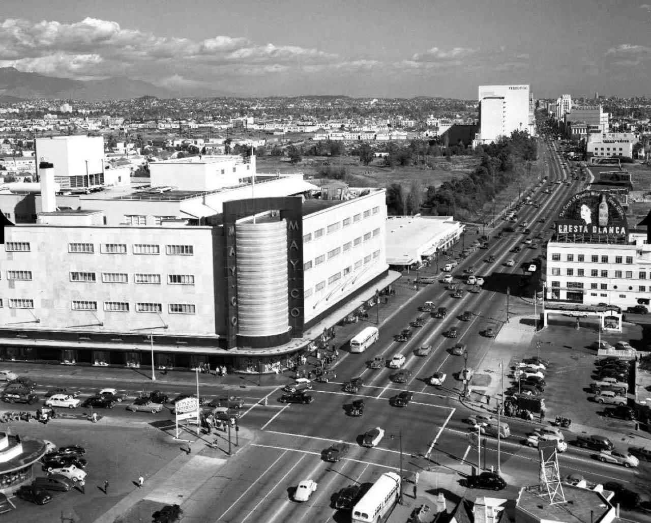
| (ca. 1948)+## – Aerial view of Wilshire Blvd facing east at Fairfax Ave, showing the May Company department store on the NE corner. Simon's Drive-in Restaurant can be seen at lower-left on the NW corner. The tall building in the distance is the Prudential Building (1948). This intersection was, and still is, referred to as the western gateway to the 'Miracle Mile'. |
Historical Notes It was not until 1928 that the Miracle Mile acquired its glamorous appellation. Ross originally gave his development a much less-memorable name: Wilshire Boulevard Center. According to a story Ross was describing his vision for the development when a friend interjected: "From the way you talk, A.W., one would think this is really a miracle mile." The name, with its obvious promotional value, stuck.^ |
 |
|
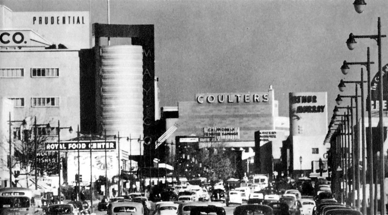
| (1940s)+## – Panoramic view using telephoto lense looking east on Wilshire Boulevard through the Fairfax Avenue intersection. We can see the May Company department store (now part of LACMA and future home of the Hollywood museum of the Academy of Motion Picture Arts and Sciences), Prudential Building, Coulter's Department Store, and the Arthur Murray Dance Studio. This “Miracle Mile” stretch of Wilshire Blvd is busy now but back then it looks positively jam-packed! |
Historical Notes Ross gave Wilshire various "firsts," including dedicated left-turn lanes and timed traffic lights, the first in the United States. He also required merchants to provide automobile parking lots, all to aid traffic flow. Major retailers such as Desmond's, Silverwood's, May Co., Coulter's, Mullen & Bluett, Myer Siegel, and Seibu eventually spread down Wilshire Boulevard from Fairfax to La Brea. Ross ordered that all building facades along Wilshire be engineered so as to be best seen through a windshield. This meant larger, bolder, simpler signage and longer buildings in a larger scale. They also had to be oriented toward the boulevard and architectural ornamentation and massing must be perceptible at 30 MPH instead of at walking speed. These building forms were driven by practical requirements but contributed to the stylistic language of Art Deco and Streamline Moderne.^ |
Fairfax and Wilshire
 |
|
| (1970)^.^ - View looking towards May Company from a northbound car on Fairfax Avenue at Wilshire Boulevard. On the right side is Ohrbachs Department Store, which opened in 1964 and closed in 1986. |
Historical Notes Originally introduced by Ford in August 1968 as a package for the 1969 model year, the Mustang Mach 1 title adorned performance oriented Mustang offerings until the original retirement of the moniker in 1978, returning briefly in 2003 and 2004.^ Albert C Martin and SA Marx's 1939-40 May Company Wilshire was still bustling here, and by this time it even had its own gasoline station. Like most of the prominent stores on the Miracle Mile and the Wilshire District, the store's main entrance was in the rear, the easier to accomodate shoppers who parked their cars in the vast lots. In 1993 May Department Stores absorbed the venerable JW Robinson's chain, and so this store was shuttered in favor of the Beverly Hills Robinson's. Fortunately, it wasn't long afterward that the Los Angeles County Museum of Art annexed the building and took great care to preserve it. It is Los Angeles Historical-Cultural Monument No.566. In October 2011 the Academy of Motion Picture Arts and Sciences, in a joint project with LACMA, announced that the building would be the site for a new motion-picture museum. |
 |
|
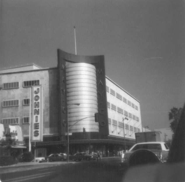
| (1977)^.^ – View looking west on Wilshire Boulevard at Fairfax Avenue, gateway to the Miracle Mile, with the iconic May Company Building on the NE corner and Johnie's Coffee Shop across the street on the NW corner. |
Historical Notes Johnies, built in 1955 as Romeo's Times Square and later the Rams Cafe, is always near the top of the list of Googie coffee-shop classics. It closed a decade ago, but it still attracts as much attention as if it were still operating. it looks the same and is, as is often said in Los Angeles, "available for filming." |
* * * * * |
Please Support Our Cause Water and Power Associates, Inc. is a non-profit, public service organization dedicated to preserving historical records and photos. We are of the belief that this information should be made available to everyone—for free, without restriction, without limitation and without advertisements. Your generosity allows us to continue to disseminate knowledge of the rich and diverse multicultural history of the greater Los Angeles area; to serve as a resource of historical information; and to assist in the preservation of the city's historic records. |
For more Historical Los Angeles Views click one of the following:
For Other Historical Views click one of the following:
See Our Newest Sections:
To see how Water and Electricity shaped the history of Los Angeles click one of the following:
Water:
Power:
* * * * * |
References and Credits
* DWP - LA Public Library Image Archive
^ LA Public Library Image Archive
*^Oviatt Library Digital Archives
^^LA Times: Photo Archive; An Oil Well on La Cienega; Mulholland Bridge; A Mountain of Red Cars; The Vincent Thomas Bridge; Hill Street Tunnels; Harbor-Santa Monica Freeway Interchange; Dodgers Caravan,1958
#*MTA Transportation and Research Library Archives
+#Facebook.com: Garden of Allah Novels
#^^Picturetrail.com: KCET - Angels Flight
#^*Downtown LA Public Art: Fort Moore Pioneer Monument
^**Flickr: Enock 1; Eric Richardson
*^#Los Angeles Conservancy: LA Stock Exchange Building; Park La Brea
^#^Pacific Electric Railway Historical Society - Alan Weeks Collection
*#*Westland.net: Venice History
*#^Forum.Skyscraper.com: Arroyo Seco Library; Westwood-Life Magazine; North Los Angeles Street
^#*Metro.net: Mulholland Drive Bridge
**#The California History Room, California State Library: William Reagh
#**Pinterest - California and DailyBreeze.com
#^#Deadhistoryproject.com: Silent Movie Theater
+**Los Angeles' Bunker Hill - Alta Visa Apartments
+##MartinTurnbull.com: Fairfax and Wilshire
^^+How Stuff Works: Chevrolet Impala
+#+Pinterest - California and DailyBreeze.com; Mid Century Hollywood
++#Facebook.com: Photos of Los Angeles
^^#The George A. Eslinger Street Lighting Photo Gallery
^^*Early Downtown Los Angeles - Cory Stargel, Sarah Stargel
***Los Angeles Historic - Cultural Monuments Listing
*^*California Historical Landmarks Listing (Los Angeles)
*^^Nuestra Señora la Reina de los Ángeles: losangelespast.com
**** Pinterest.com: Los Angeles Dodgers; Los Angeles and Hollywood; MacArthur Park w/Downtown Skyline; Gilmore Self-Service Gas Station
**^*California State Library Image Archive
**^#Vintage Los Angeles: Facebook.com - Gilmore Stadium and Field; Cruising Hollywood Blvd
^^^^Depaul.edu: Night Train 55
**#^Vincent Thomas Bridge - Facts and Figures
*#**Flickr-Los Angeles in Good Light - Ron Reiring
^#^^Flickr.com: Michael Ryerson
*#^#Life.time.com: Stoked-Life Goes Surfing
^#^#Pinterest: Bygone Los Angeles
*#*#Abandoned & Little-Known Airfields – Paul Freeman
^#*#LA Magazine: Beverly Park Ponyland
^^##Pacific Electric Railway Historical Society
^^*#Historic LA Theatres: Downtown Broadway Theatres
^^#*LA Observed.com: Decommissioned Street Cars; Bunker HIll, 1964
*^^*Pinterest.com: Bertrand Lacheze
^^**Pinterest.com: Vintage California
^^++Huntington Digital Library Archive
*##*Pinterest.com: Trucks, Pick-Ups, and Gas Stations
*##^LAist.com: Harbor Freeway, 1969; Century Plaza Hotel
##*^Port of Los Angeles: portoflosangeles.corg
##^*Calisphere: University of California Image Archive
##^^Cinema Treasures: Olympic Drive-In
#**#California State University Northridge History: csun.edu
#++#The Pacific Electric Railway Historical Society (PERyHS)
#*##Daily News: Mulholland Bridge
#^**The Go Go's: N/W Corner of Hollywood and Vine
#^*#Flickr.com: Paul Bajerczak
##^#Facebook.com: Classic Hollywood-Los Angeles-SFV
^***UCLA Library Digital Archive
^^^*KCET: Welcome to L.A. River; Four Level Interchange; Construction of 5 Southern California Freeways; Beverly Park and Ponyland; Before the 'Carmageddon': A Photographic Look at the Construction of 5 SoCal Freeways; Seventh and Broadway; L.A.'s First Freeways
****^Facebook.com: West San Fernando Valley Then And Now
*^^^^Los Angeles Maritime Museum
^^^**tumblr.com: John Ferraro Office Building; DWP Office Building
**^^^Facebook.com - San Pedro's Original Website, San Pedro.com
#*#**Facebook.com: Beverly Park - L.A.'s Kiddieland
**#**LMU Digital Archive
**^ Noirish Los Angeles - forum.skyscraperpage.com; Westwood-Life Magazine; Selling Papers on Olive; California Federal Plaza Building; Downtown Aerial 1958; 1949 Construction of 101 Freeway; 1953 Harbor Freeway Construction; Wilshire Blvd, 1949; Zephyr Room and Brown Derby Postcard View; Aliso Before and After 101 Frwy; Vincent Thomas Bridge; Gilmore Aerial; Hollywood Frwy Traffic Jam; 2012 Downtown Skyline; View from GOB; Bonaventure Hotel Aerial; Hollywood and Vine
^* Wikipedia: Hollywood Sign; Carthay Circle Theatre; Fairfax High School; Park La Brea; San Vicente Boulevard; Etymologies of place names in Los Angeles; Los Angeles Central Library; Broadway Tunnel; Pershing Square; Pacific Electric Railway; Gilmore Field; GilmoreStadium; Union Station; Westwood; 6th Street Viaduct Bridge; Figueroa Street Tunnels; Chavez Ravine; 2nd Street Tunnel; Hollywood Freeway; Los Angeles International Airport; Los Angeles City Hall; Wilshire Boulevard Temple; Egyptian Theatre; The Pig 'N Whistle; Sunland-Tujunga; Van de Kamp Bakery Building; Los Angeles County Art Museum; Los Angeles City Oil Field; Los Angeles Railway; Miracle Mile; Interstate 405; Chevrolet Impala; Playa Vista; Harbor Frwy (Interstate 110); History of Los Angeles Population Growth; Los Angeles City Hall Lindbergh Beacon; May Company California; Four Level Interchange; California Federal Bank; Harbor Freeway; Arroyo Seco Parkway; Brown Derby; 2004 Los Angeles Skyline; LA's Oldest Palm Trees; Vincent Thomas Bridge; World Cruise Center; CSUN; Westwood; Westwood Village; UCLA; History of UCLA; 1950s Americal Automotove Culture; Pershing Square; Century Plaza Hotel; California Incline
< Back