Los Angeles Department of Water and Power Building |
(also known as the John Ferraro Building) |
 |
|
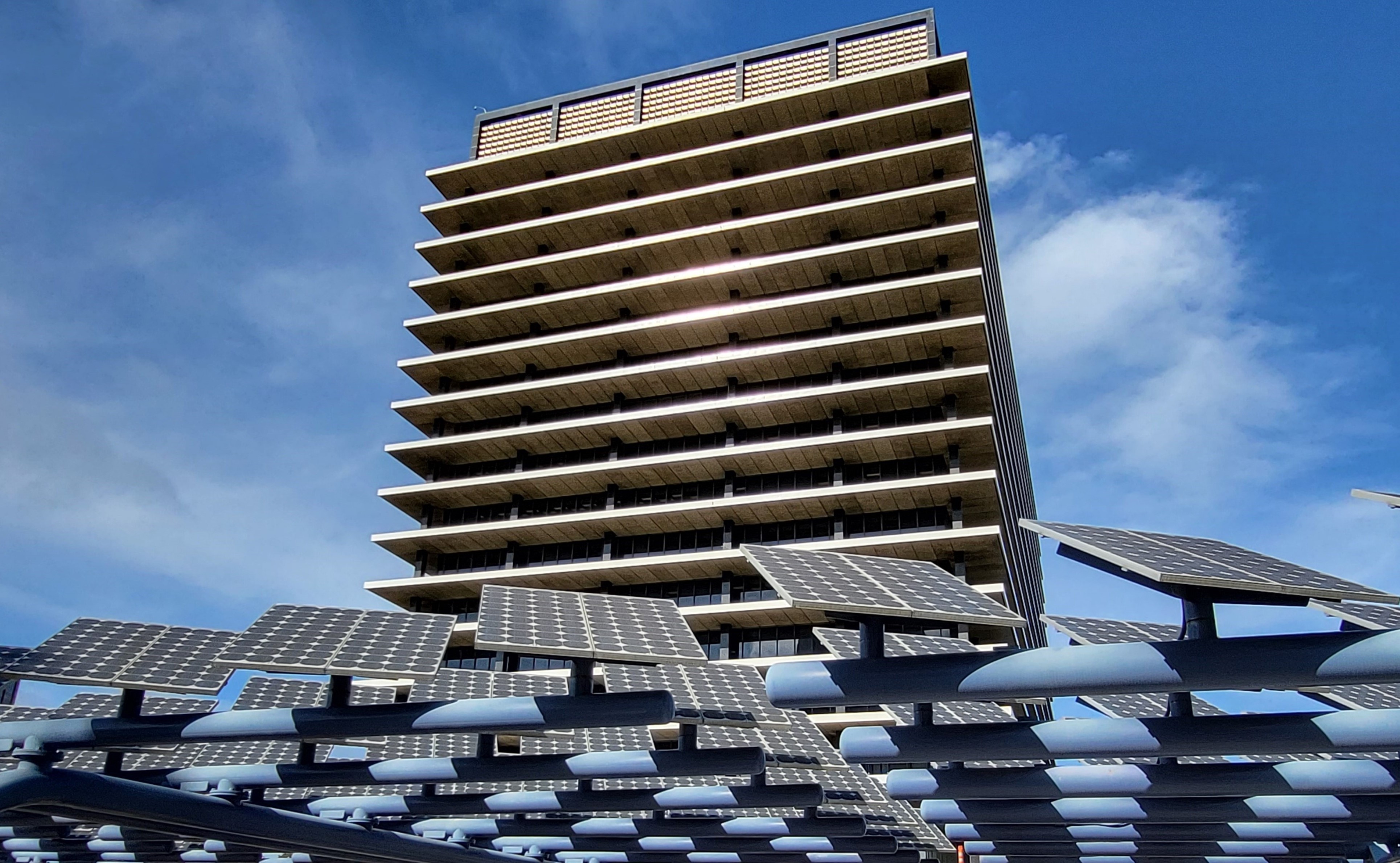
| (2023) - View of the Los Angeles Department of Water and Power (LADWP) Building at 111 N. Hope Street in Downtown Los Angeles. Photo by Jack Feldman. |
The Department of Water and Power Headquarters, located on Bunker Hill, occupies one of the most prominent sites in Los Angeles. As the center of operations for the largest municipal utility in the United States, the building stands as both a functional headquarters and a civic landmark—symbolizing the essential role water and power have played in shaping the city’s growth and identity. |
 |
|
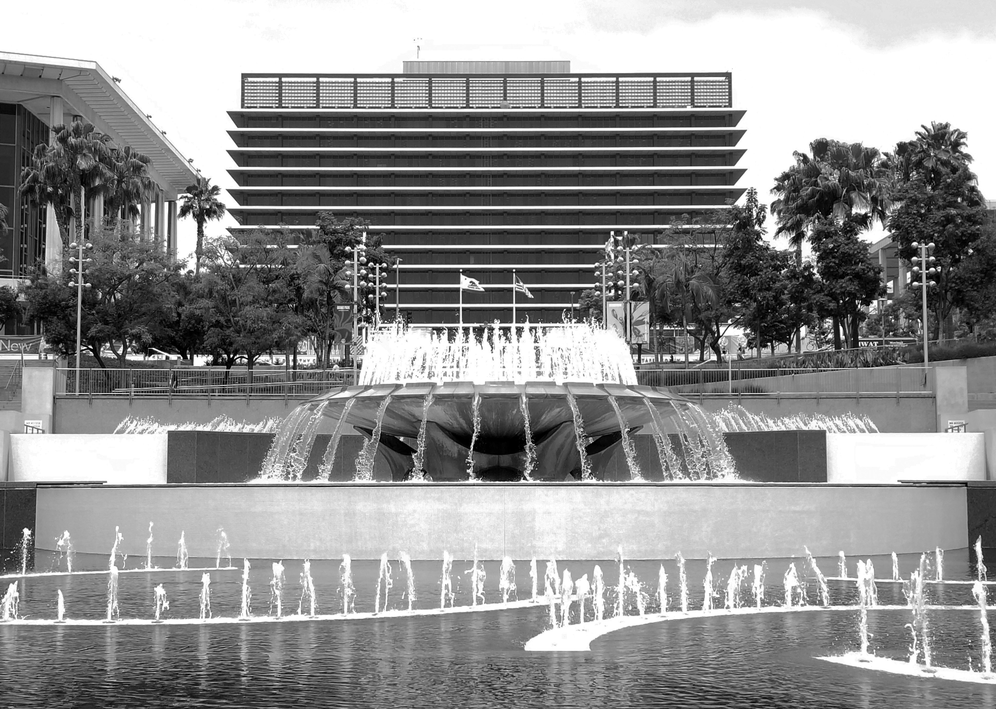
| (2019)* - View looking toward the John Ferraro Building (formerly the DWP General Office Building) over the fountains at the west end of Grand Park, with the Dorothy Chandler Pavilion visible on the left. Photo by Jack Feldman. |
Opened in 1965, the LADWP headquarters is one of the city’s most notable examples of Corporate International architecture. Designed by Albert C. Martin & Associates, the seventeen-story structure features deep horizontal sunshades and an extensive reflecting pool that creates the illusion of the building floating above water. On September 21, 2011, it was designated Los Angeles Historic-Cultural Monument No. 1022, recognizing its architectural and civic significance. |
* * * * * |
History
 |
|
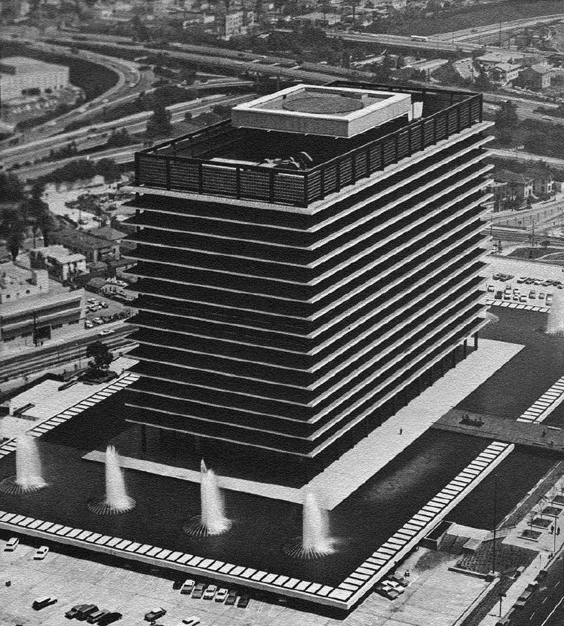
| (1965)* - View showing the Los Angeles Department of Water and Power’s new General Office Building shortly after its completion. Today it is known as the John Ferraro Building. |
Completed in 1965, the General Office Building (GOB) was designed by Albert C. Martin and Associates, who also served as structural engineers. The building’s sleek, minimalist lines and integrated fountain pools reflect the modernist ideal of merging technology, architecture, and environment. The structure contains over 1.2 million square feet of office space and remains one of Los Angeles’s enduring mid-century icons. |
 |
|
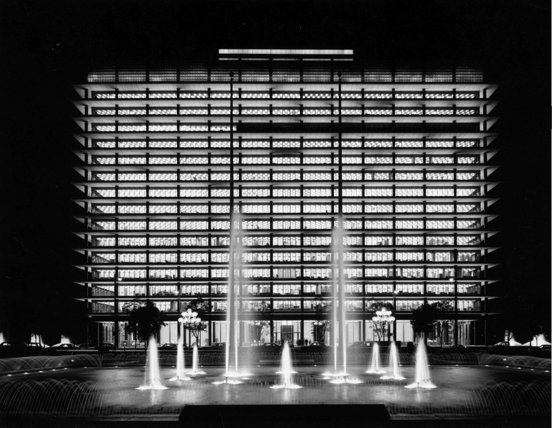
| (1966)* - View of the Department of Water and Power’s General Office Building from the front of the Dorothy Chandler Pavilion. Photo by Julius Shulman. |
Historical Notes This classic Julius Shulman image captures the DWP Building as part of the broader Los Angeles Civic Center cultural complex, alongside the Music Center’s Dorothy Chandler Pavilion, Ahmanson Theatre, and Mark Taper Forum—all products of the city’s ambitious 1960s redevelopment of Bunker Hill. |
 |
|
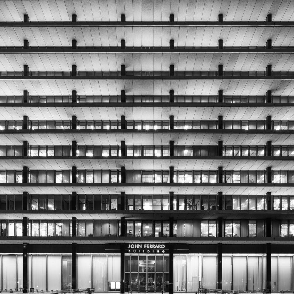
| (2019)* – Night view of the John Ferraro Building showing its main entrance at 111 N. Hope Street. |
In November 2000, the General Office Building was renamed the John Ferraro Building in honor of Los Angeles City Councilman John Ferraro, who represented the 4th District for 35 years and was the city’s longest-serving council member. The illuminated fountains and soft lighting continue to make the building one of the city’s most recognizable nighttime landmarks. |
* * * * * |
Pre-Construction: Future Location of the DWP Building
 |
|
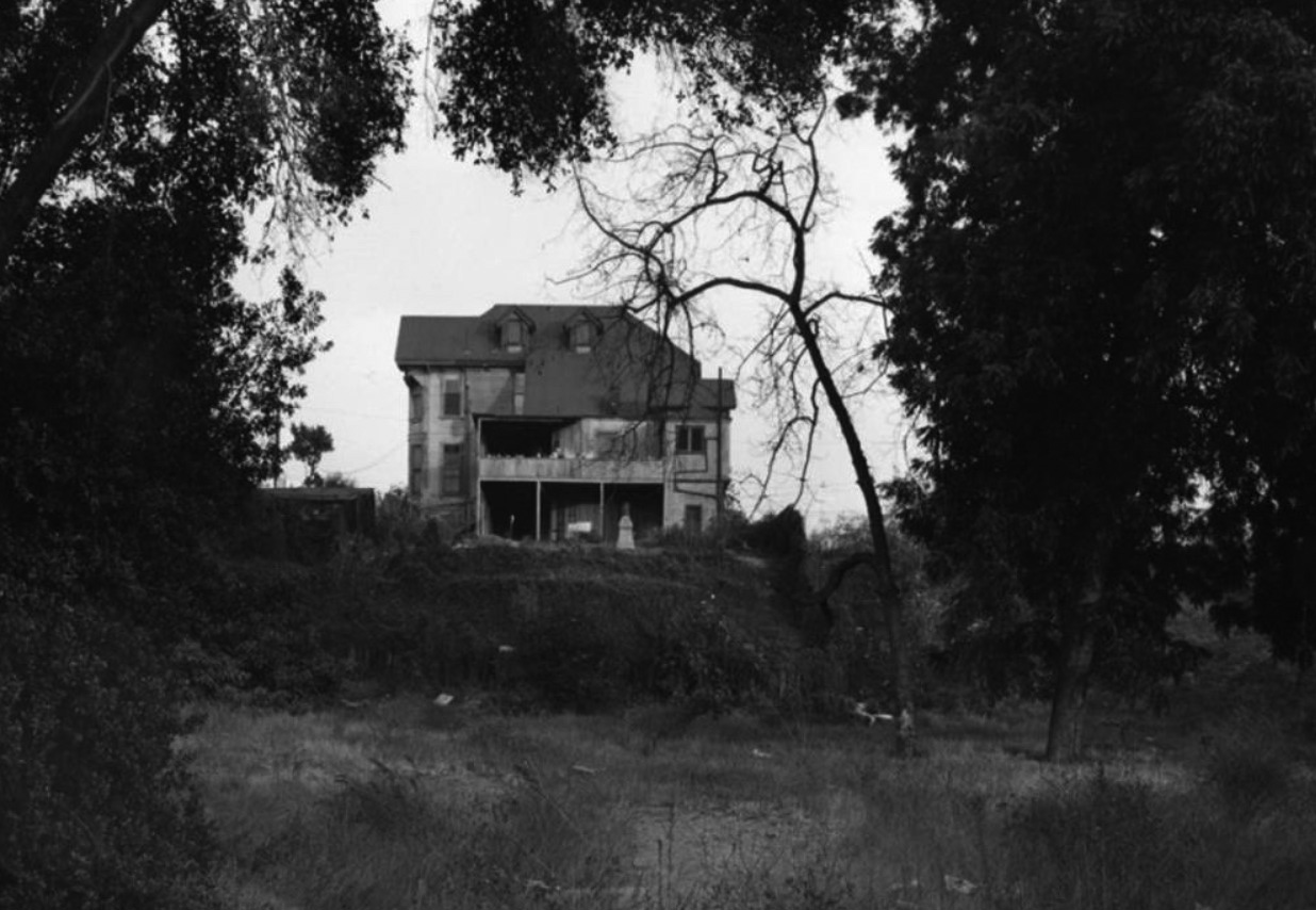
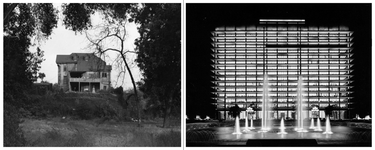
| (1959)* - Rear view of a residence located at 231 North Hope Street, known as the Basserman home. This is the current location of the Water and Power Building. The view is from Flower Street looking east through a vacant lot where a residence at 232 North Flower once stood. An incinerator is visible near the structure. Photo by William Reagh |
Historical Notes Even though the above address (231 N. Hope St) is different than that of the Water and Power Building (111 N. Hope St), they are at the same general location. Click HERE to see Google Map. |
 |
|
| (1959)* – Looking south on Hope Street from near Temple Street, showing a run-down two-story Victorian house with bay and dormer windows. Palm trees are visible in the distance, and retaining walls are in the foreground. This would be the future location of the Department of Water and Power Building (111 N. Hope Street). Photo by William Reagh |
 |
|
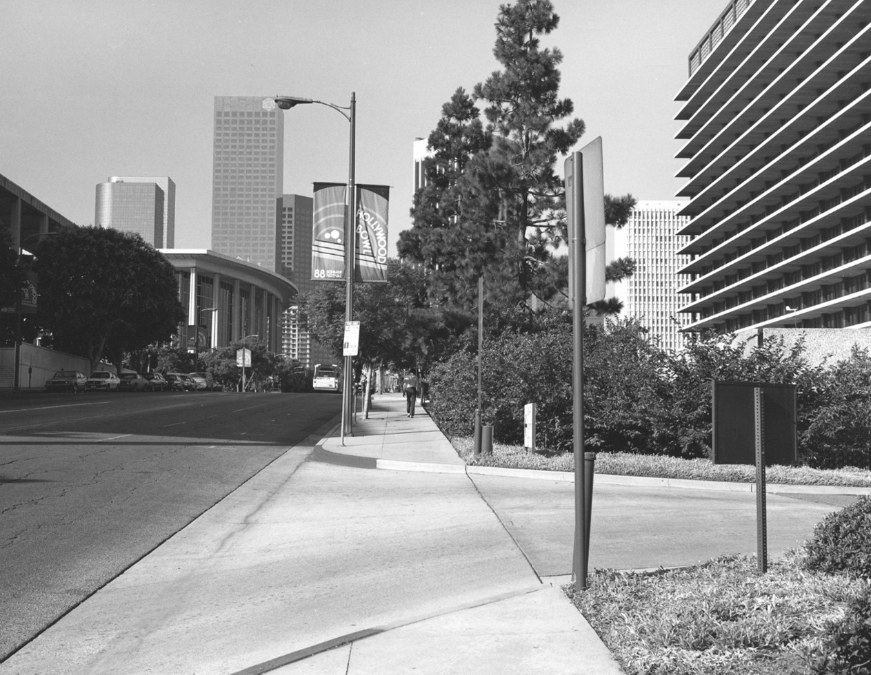
| (1988)* – Looking south on Hope Street from near Temple Street, showing the 1966-built Department of Water and Power Building on the right, where an old Victorian home once stood. The Music Center and downtown skyline are visible in the distance. Photo by William Reagh |
Before and After
 |
|
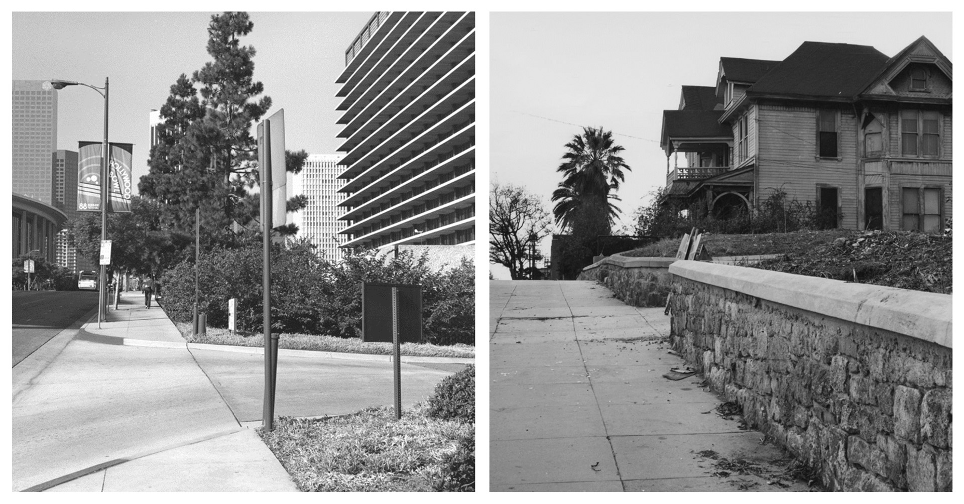
| (1959 vs 1988)* – Looking south on Hope Street from near Temple Street, showing the 1966-built Department of Water and Power Building on the left, standing where an old Victorian home once stood (now seen on the right). |
 |
|
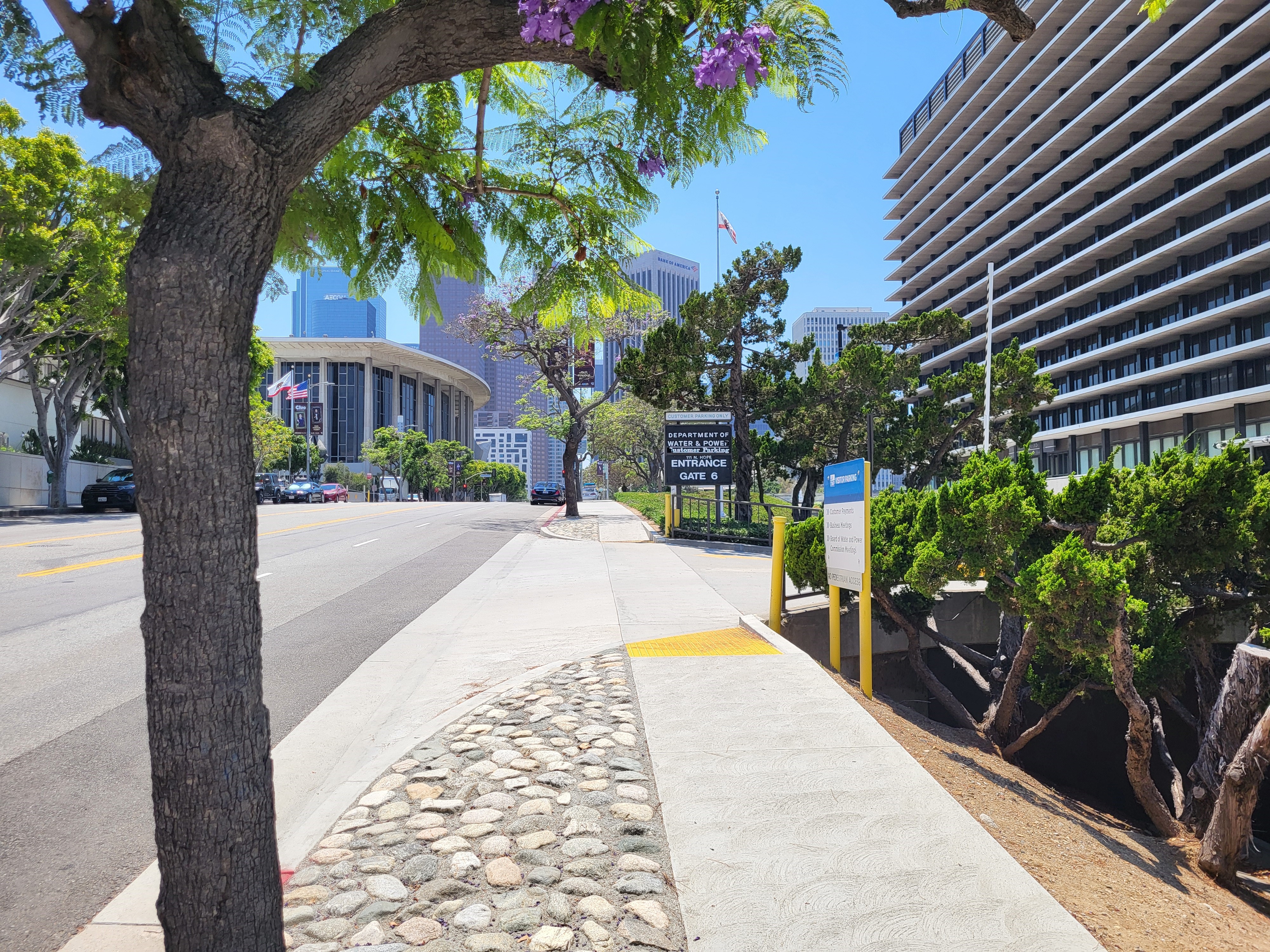
| (2024) – Looking south on Hope Street from near Temple Street, showing the 1966-built Department of Water and Power Building on the right, where an old Victorian home once stood. The Music Center and downtown skyline are visible in the distance. Photo by Jack Feldman |
Before and After
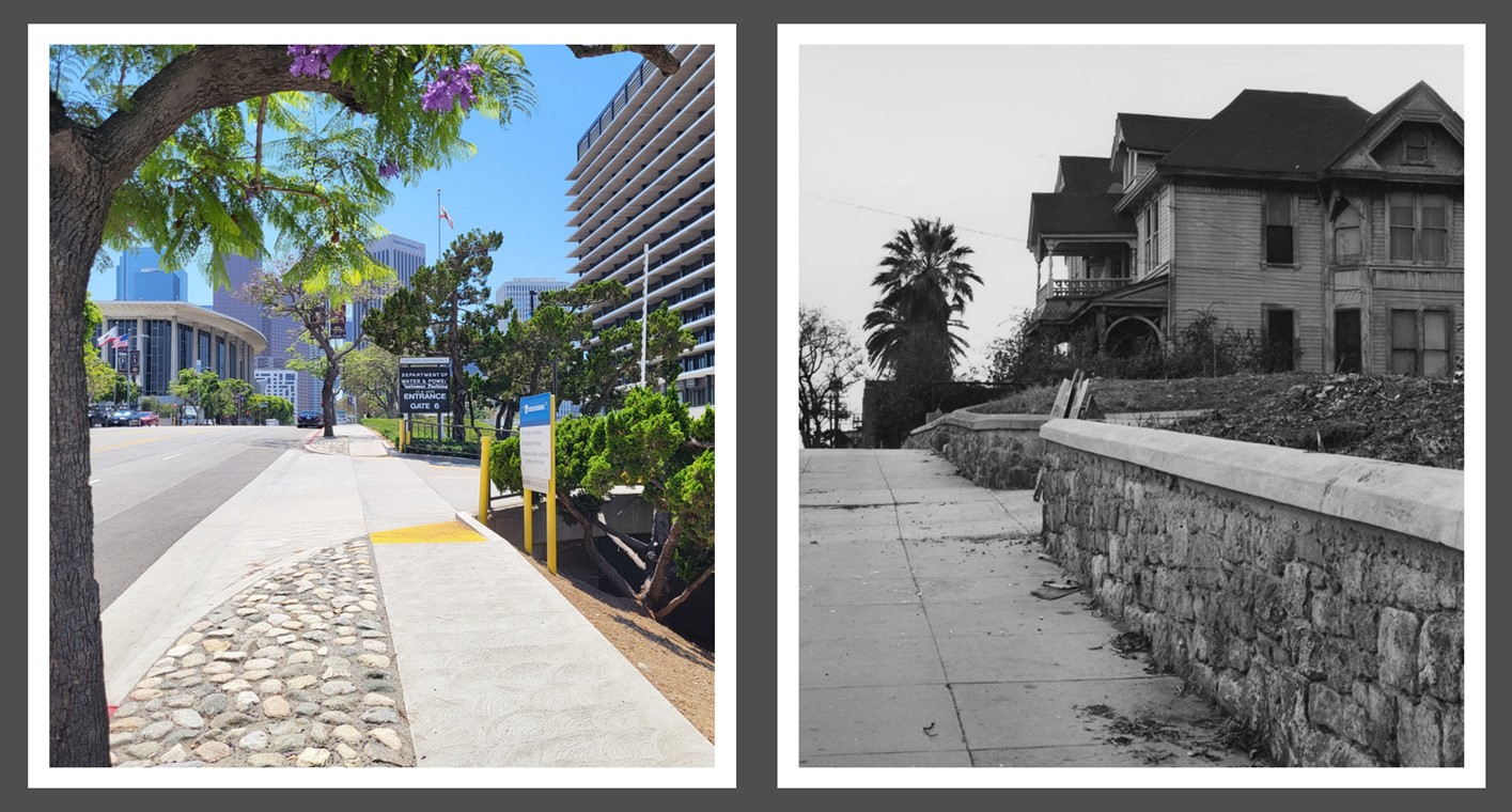 |
|
| (1959 vs 2024)– Looking south on Hope Street from near Temple Street, showing the Department of Water and Power Building on the left, standing where an old Victorian home once stood (now seen on the right). |
* * * * * |
Pre-Construction
 |
|
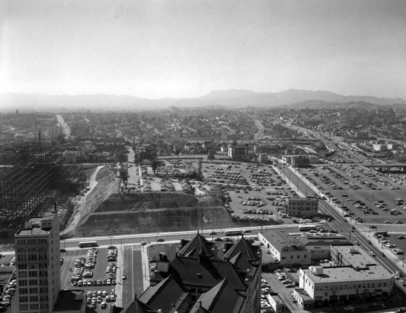
| (Early 1950s)^* - View looking slightly northwest from City Hall. Bunker Hill in the distance is still covered with multiple dwellings. Parking lots are seen throughout the photo. The County Courthouse on the left is under construction. |
 |
|
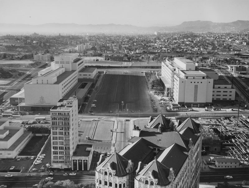
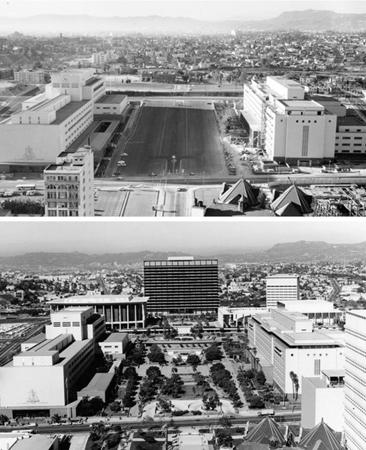
| (ca. 1960)* - View from City Hall looking toward Bunker Hill prior to construction of the GOB and Music Center. Both the County Courthouse and the Hall of Adminstration buildings are now up. |
Historical Notes The tall, slender building on the left is the Law Building. The old Hall of Records, a diagonally set structure, is in the lower right foreground. In the center of the photo are the County Courthouse and County Hall of Administration. In the distance is the future location of the Department of Water and Power building and the Music Center. |
 |
|
| (ca. 1960)* - View from City Hall looking toward Bunker Hill prior to construction of the GOB and Music Center. Both the County Courthouse and the Hall of Adminstration buildings are now up. Image enhancement and colorization by Richard Holoff. |
 |
|
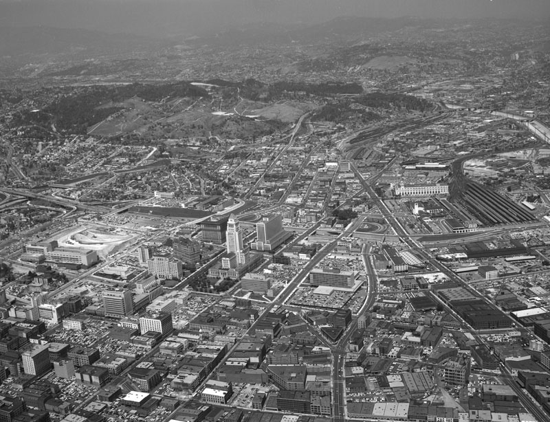
| (1957)* - Aerial view of Los Angeles from an altitude of approximately 5,000 feet. View is looking northwest with the Civic Center at center, and City Hall's tower visible in the middle. |
Historical Notes The empty land to the left of center is future location of both the DWP General Office Building and the Dorothy Chandler Pavilion. |
* * * * * |
Construction Begins
 |
|
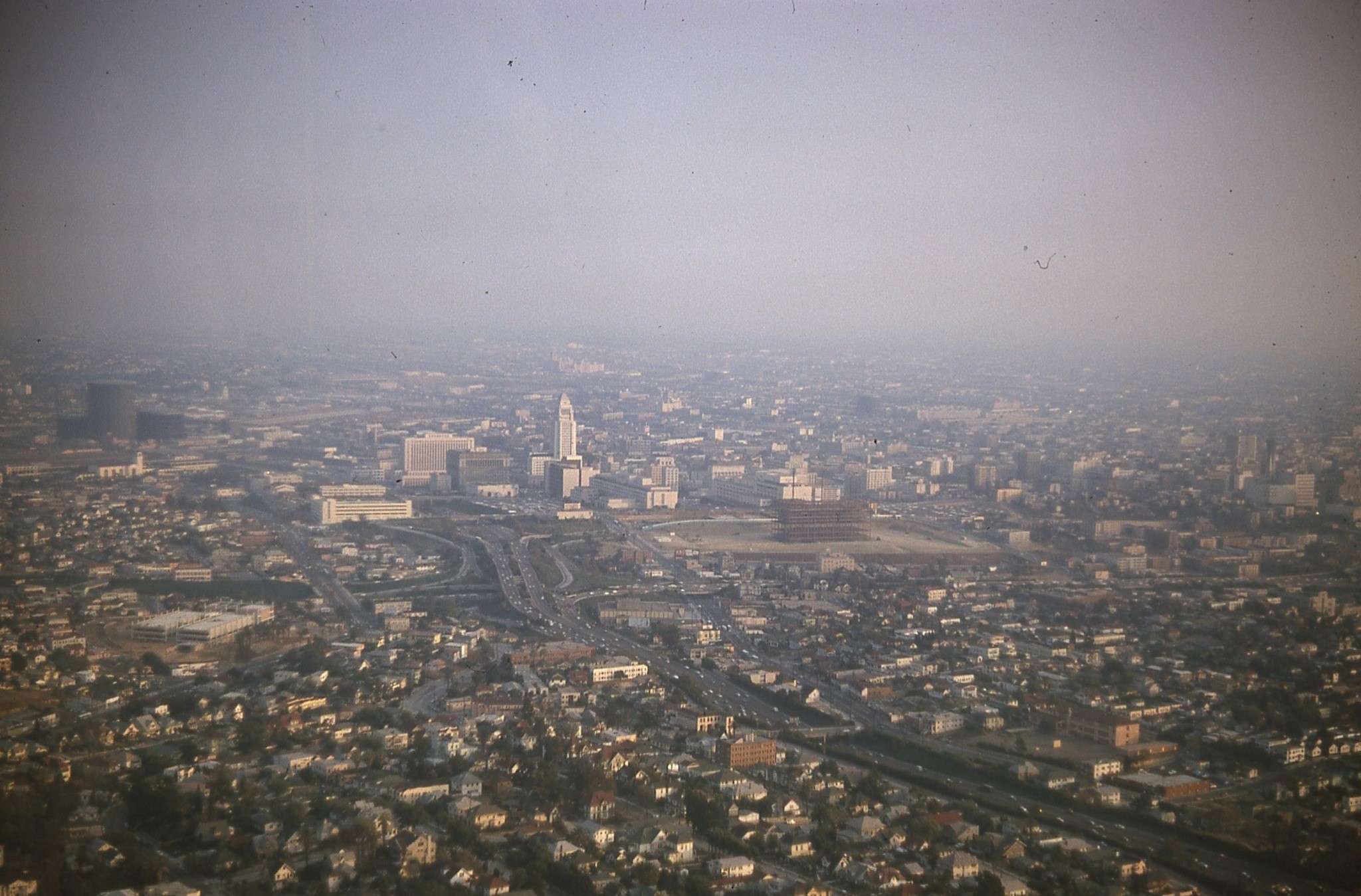
| (1962)* – Aerial view looking southeast showing the LADWP Building (GOB) under construction on Bunker Hill. Photo courtesy of Drena Hills. |
Historical Notes The construction of the LADWP Building began in 1962 and was completed and opened in May 1965. |
 |
|
| (ca. 1963)* - Construction of the DWP General Office Building with City Hall in the background. To the right of the GOB can be seen the Music Center which was being consructed at the same time. |
Historical Notes The 17-story Department of Water & Power Office Building was constructed on Bunker Hill with the purpose of consolidating 11 building offices scattered across Downtown LA and house its 3,200 employees. |
 |
|
| (ca. 1963)* - Looking east from a neighborhood west of the Harbor Freeway (foreground) showing the construction of the 17-story General Office Building of the Department of Water and Power, located at 111 N. Hope Street, and the Music Center. First Street is seen on the right side, and the Civic Center is partially visible in the background. |
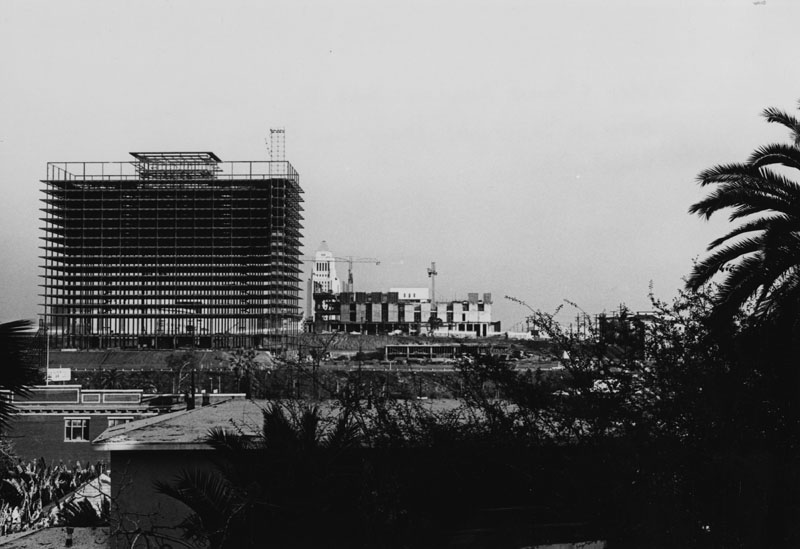
Historical Notes The A.C. Martin and Associates designed building offered some unique high-technology features in that It was designed to utilize the pool surrounding the structure as part of the air conditioning system and to heat the building without the use of a boiler. |
 |
|
| (ca. 1963)* - Looking east from a neighborhood west of the Harbor Freeway showing the construction of the 17-story General Office Building. |
 |
|
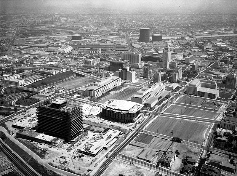
| (1963)* – Aerial view looking northeast showing the General Office Building taking form. |
 |
|
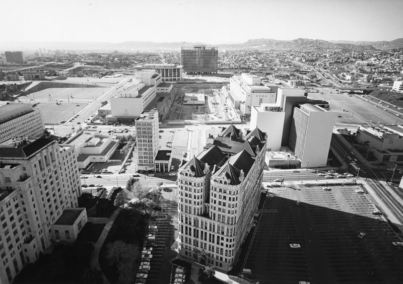
| (ca. 1963)* - Photo taken from the City Hall Tower looking northwest showing the late construction stages of the DWP General Office Building and Dorothy Chandler Pavilion. |
Historical Notes The old State Building can be seen on the left, and the old Hall of Records (diagonally set building) is on the lower right foreground with a large, practically empty parking lot to the right of the building. In the center of the photo are the County Courthouse, County Administration, and construction of the County mall (excavated area). In the distance is the Department of Water and Power building, and the Dorothy Chandler Pavilion and Music Center are on the left of DWP (between DWP and County Courthouse). |
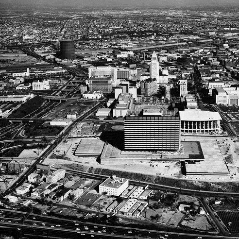 |
|
| (ca. 1963)* - Aerial view looking east toward City Hall. The DWP General Office Building is nearly complete as well as the Dorothy Chandler Pavilion. The Ahmanson Theater and Mark Taper Forum would not be completed until 1967. |
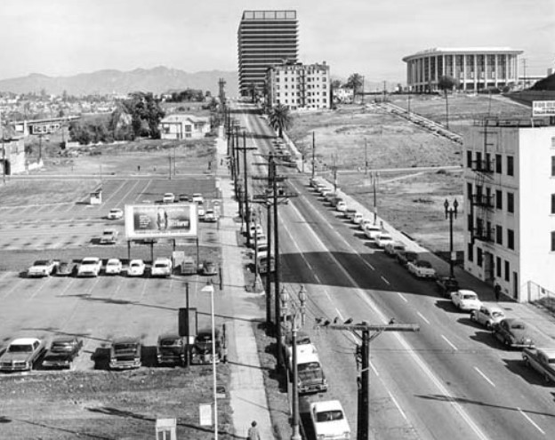 |
|
| (1964)#* – View looking north on Flower Street from 4th Street, through the former Bunker Hill neighborhood. The newly constructed Dorothy Chandler Pavilion, right, and the Department of Water and Power headquarters can be seen past 1st Street. |
 |
|
| (1964)** - An aerial view of the Los Angeles Civic Center, looking east with the Department of Water and Power building and unfinished Music Center in the foreground. |
Historical Notes The first occupants moved into the GOB on May 14, 1965. One month later the building was formally dedicated in a ceremony attended by civic officials and business leaders.^ |
* * * * * |
Opening Ceremony
 |
|
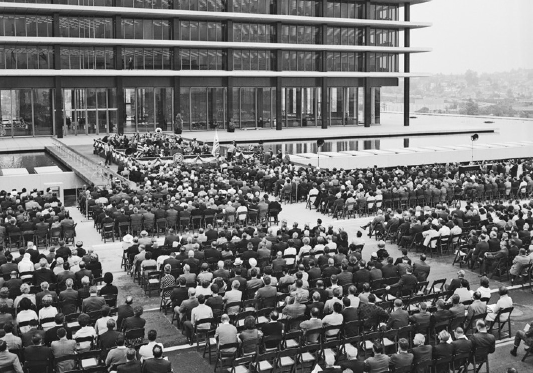
| (1965)*^ - Hundreds of people attend the opening ceremony for the new General Office Building on June 24, 1965. |
Historical Notes On June 24, 1965, the GOB was formally dedicated. As part of the ceremony the eight fountains outside the building were turned on by Elizabeth Scattergood and Rose Mulholland, granddaughters of the two men who were DWP's first chief engineers. |
 |
|
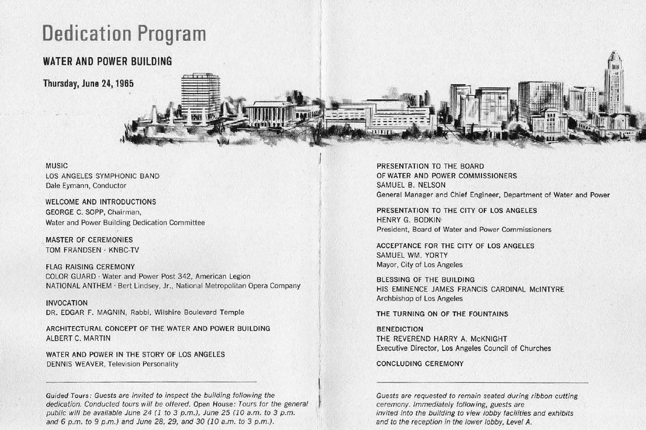
| (1965)*^* - Program for the Water and Power Building dedication ceremony (Courtesy of John Harrigan). |
Click HERE to see the entire Water and Power Building Dedication Program |
.jpg) |
|
| (June 24, 1965)*^ - The above switch was used to illuminate the water fountains during the General Office Building's opening ceremony. |
Historical Notes Plaque reads: "On the above date the new Department of Water and Power General Office Building was dedicated and as part of the program Miss Rose Mulholland and Miss Elisabeth Scattergood together pressed this key which officially began the operation of the illuminated water fountains." It should be noted that the same switch used for the GOB dedication was also used when the first power from Hoover Dam first arrived in Los Angeles (Click HERE to see more in Construction of Hoover Dam). |
 |
|
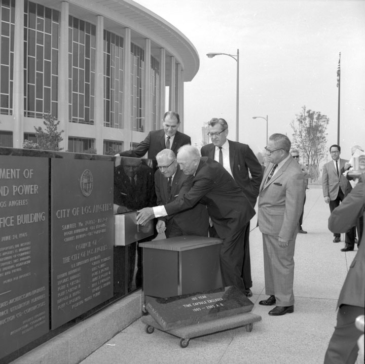
| (1965)* - Water and Power Commissioners and General Manager close the time capsule - the granite identification marker in front of the new Department of Water and Power office building awaits the tenant it will have for the next 100 years. |
Historical Notes One hundred years from July 29, 1965, in the year 2065, curious inhabitants of Los Angeles will remove from the granite identification marker in front of the new Department of Water and Power office building a sealed copper time capsule containing historical records and current data on Los Angeles and on the Department of Water and Power. In a brief ceremony attended by the Board of Water and Power Commissioners, DWP management and the dedication committee for the new building, the hermetically sealed copper container was placed in its niche in the marker to await the 21st Century. Among the objects it contained were the Department’s Annual Report, financial reports, and other publications; the City Charter; Department organization chart and complete list of present personnel; booklets, press articles, pictures, a tape recording and other records of the new building’s dedication; photos of Mayor Yorty, Members of the Board, General Manager Nelson, and other notables, and other material of historical interest. A total of 85 items was sealed in the 10” x 10” x 36” container. In a letter addressed to the Citizens of Los Angeles and the Personnel of the Department of Water and Power in the Year 2065, General Manager and Chief Engineer Samuel B. Nelson wrote, “In order to provide a record of the Department of Water and Power of the City Los Angeles in the Year 1965 when this Water and Power building was newly completed and officially dedicated on June 24, 1965, a collection of representative materials has been assembled and placed in this time capsule. “It is the hope of the Board of Water and Power Commissioners, the Management of the Department and its employees that the contents of this capsule will not only be of interest to our successors of the twenty-first century but also of service in preserving information of historical value. The Department of Water and Power is deeply aware of its obligation to the past and its heritage from those pioneers who shaped the course of development of the water and power systems of the City of Los Angeles and thus helped shape the destiny of the City itself. The Department also is conscious of its responsibility to carry on these traditions of service and to transmit them undiminished to the generations of the future. We hope that this time capsule and its contents will assist and enhance this historical process and purpose.” |
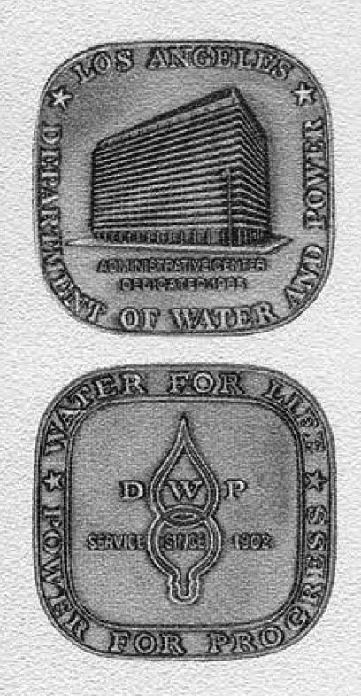 |
(1965)*^* - Pins commemorating the dedication of the Los Angeles Department of Water and Power Administrative Center (GOB).The lower pin reads: DWP - SERVICE SINCE 1902 - WATER FOR LIFE - POWER FOR PROGRESS
|
 |
|
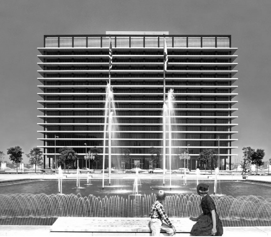
| (1965)*^ – View of a woman and child sitting on the eastern edge of fountain in front of the Music Center looking west toward the newly opened Los Angeles Department of Water and Power General Office Building. |
 |
|
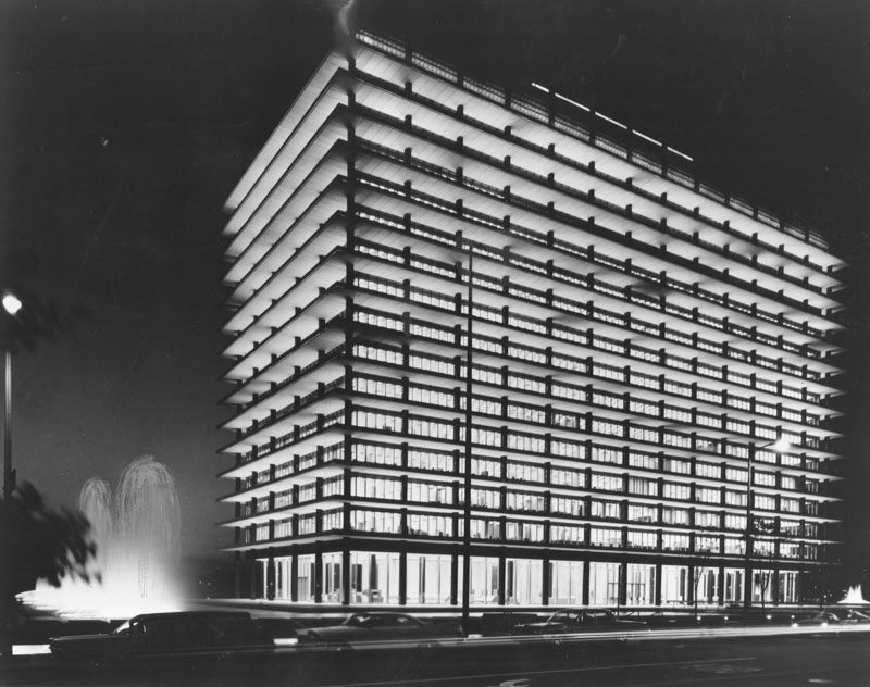
| (1966)* - Night view of a well lit Department of Water and Power building, including fountains, as seen from the Dorothy Chandler Pavillion across the street. |
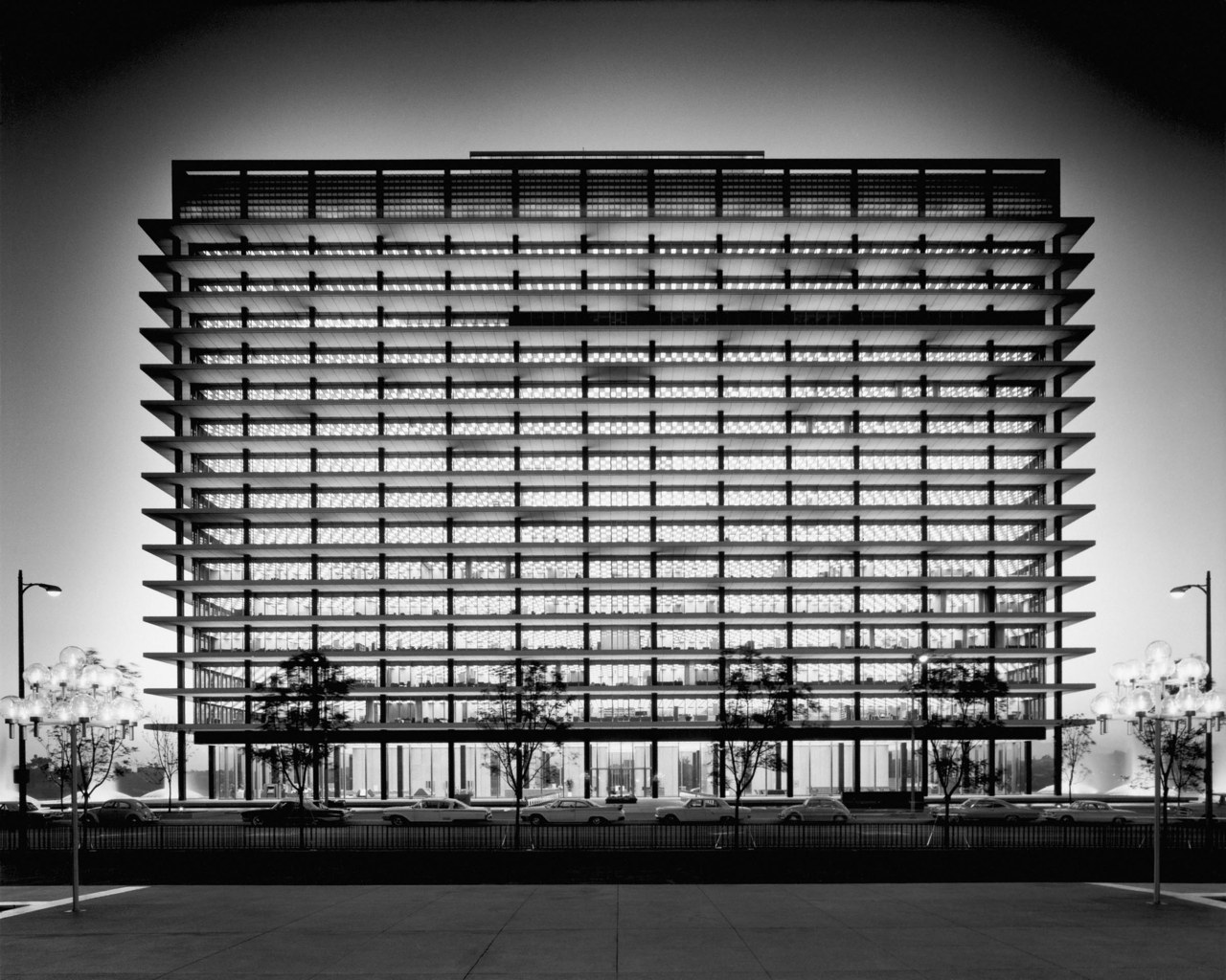
Historical Notes Constructed of steel, glass and concrete, the 287 foot high building rises from a 625 by 350 foot reflecting pool that surrounds the structure. The main entrance to the building is at 111 North Hope Street across a streamlined black slate bridge spanning the reflecting pool. |
 |
|
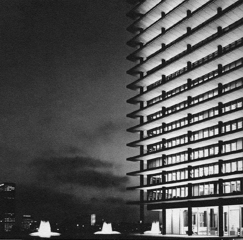
| (ca. 1965)^*^ - View showing the newly constructed GOB at dusk with three of its eight fountains in view. |
Historical Notes The combination of pool and fountains, floodlighting of the fountains and the building, and the architecture of the building itself symbolically represent the Department and its vital services to Los Angeles of "water" and "power." The pool and its eight fountains serve functionally as an integral part of the building's air conditioning system. |
 |
|
| (1965)*^* – Sketch rendering of the new LA Department of Water and Power General Office Building, designed by A.C. Martin and Associates. |
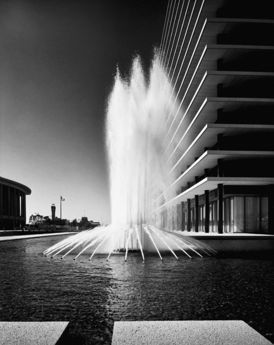
Historical Notes The aggregate-clad pool is the most prominent feature of the building and encircles the building like a moat. It is spanned on its eastern side by a wide bridge that connects to a linear green space and a sidewalk along Hope Street. Divided evenly between the north and south sides of the building, eight fountains with golden lights and choreographed jets are positioned within the pool. Integrated with the building’s innovative air-conditioning system, the pool was designed to contain 1,250,000 gallons of water while the pump circulates 20,000 gallons per minute. |
 |
|
| (1965)^ – View looking north showing one of the eight foutnains in full operation with the newly constructed DWP Building seen on the right. On the left is the Dorothy Chandler, also completed in 1965. Julius Shulman Photography Archive, Research Library at the Getty Research Institute |
 |
|
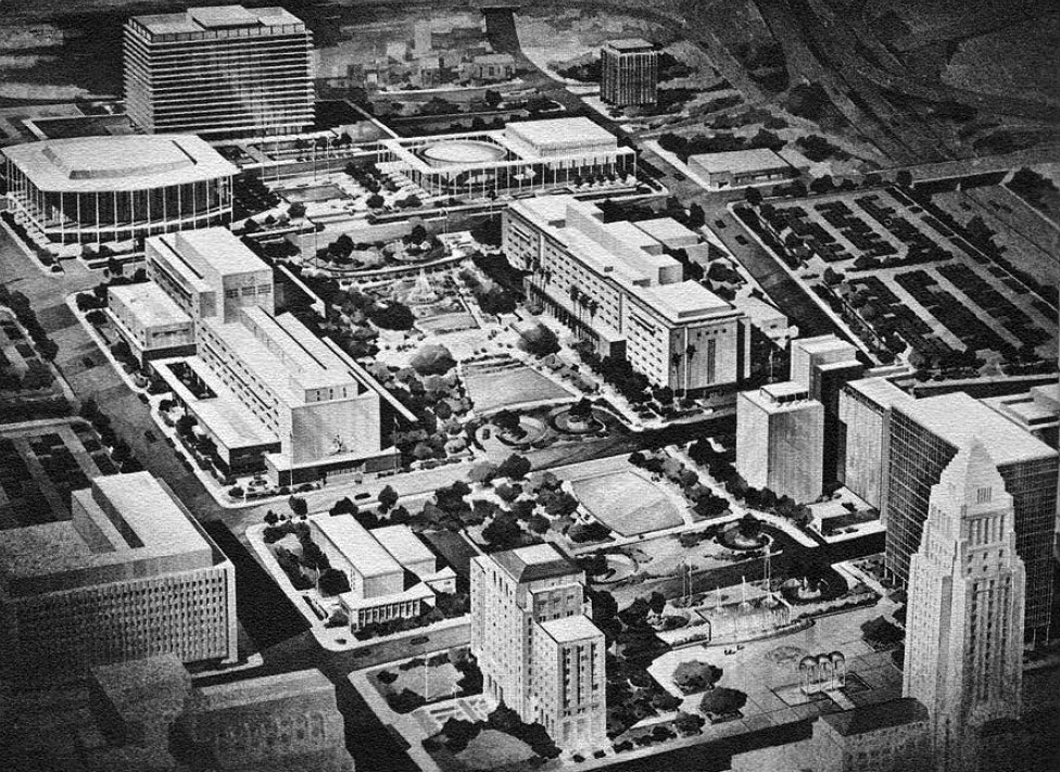
| (1960s)* – Artist’s rendering of Civic Center Mall bookended on the west by DWP General Office Building and on the the east by City Hall. |
Historical Notes As the first high-rise building on top of Bunker Hill, it occupies the key site on the west side of the major civic axis balanced by, yet not overshadowing, City Hall (for which the Albert C. Martin firm was part of the project team almost forty years before). |
* * * * * |
Early Views of Bunker Hill (Prior to Construction of the GOB)
 |
|
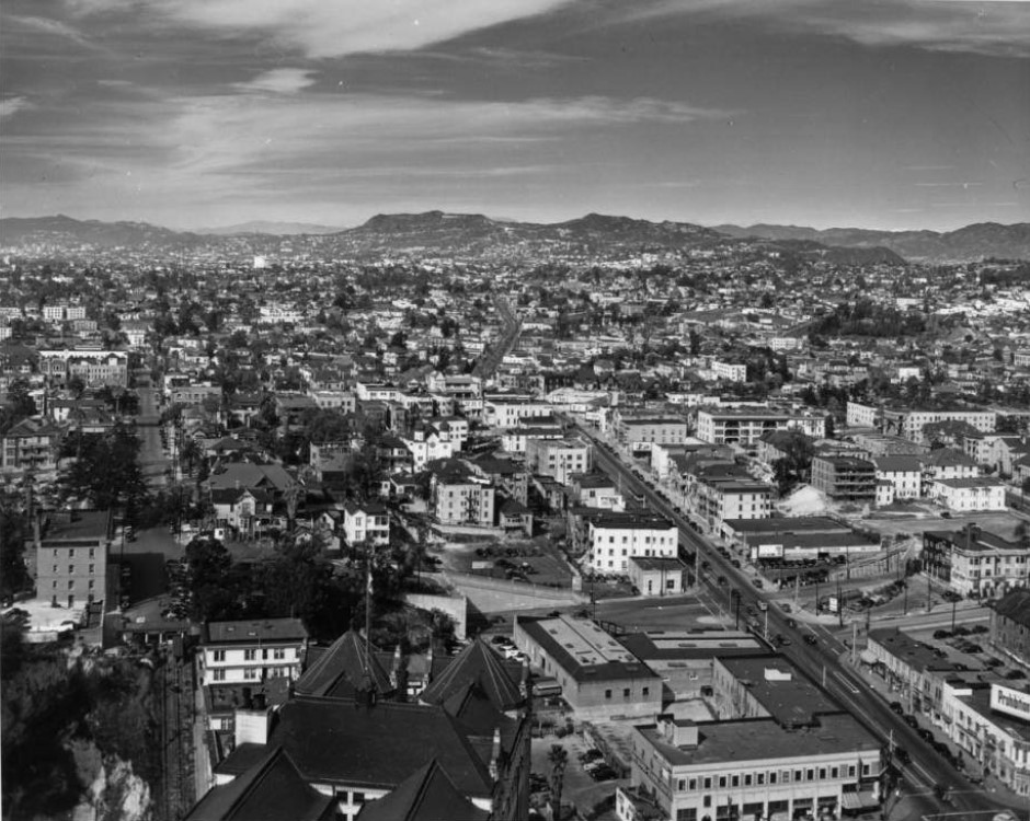
| (ca. 1937)^* - View looking northwest from the City Hall tower over the Hall of Records. Bunker Hill is covered with multiple dwellings. |
Historical Notes The prominent street running diagonally up from the lower right is Temple Street, beginning at its intersection with Broadway (barely seen). The ornate rooftop in the foreground belongs to the Hall of Records, which extended from Spring Street to Broadway. Court Street can be seen running directly away from the camera near the left edge, with Court Flight—Los Angeles’ second funicular railway—descending from the eastern end of Court Street down to Broadway (out of view). In the distance, the Hollywood Hills and Mount Lee can be seen, with the faint “Hollywoodland” sign visible along the ridge. |
 |
|
| (ca. 1940)* – Postcard aerial view looking northwest showing City Hall and the Civic Center. The State Building and Hall of Records can be seen on Spring Street at center-left. The Hall of Justice, Federal Courthouse and U.S. Post Office Building (built in 1940), and International Bank Building are at center-right on Temple Street (to the right of City Hall). Bunker HIll at upper-left is still covered with residential buildings. |
Historical Notes By 1940, the Civic Center was growing into the administrative heart of Los Angeles. City Hall, completed in 1928, dominated the skyline, surrounded by new state and federal government buildings. To the northwest, Bunker Hill still retained its dense mix of aging Victorian homes and small apartment houses—remnants of an earlier era when the hill was one of the city’s most desirable residential neighborhoods. |
 |
|
| (1943)* – Night view looking west toward Bunker Hill as seen from the observation deck of City Hall with the Los Angeles County Hall of Records in the foreground. Streets are lit up, including Broadway (running left to right at bottom), Temple Street (right), and Court Street (running away from the camera at center). |
Historical Notes Downtown Los Angeles glows in wartime blackout conditions, its streetlights dimmed but still illuminating the grid of roads leading up Bunker Hill. The mix of civic buildings and older housing reveals a city balancing between its early 20th-century past and a modern future that would soon demand sweeping redevelopment. |
 |
|
| (1945)* - Aerial view over Bunker Hill looking east toward the Los Angeles Civic Center before construction of the Hollywood and Harbor Freeways. Temple Street runs along the left, and Court Street is seen on the right heading toward the Old Hall of Records and City Hall. Figueroa Street runs horizontally near the bottom of the frame. |
Historical Notes In this view, Bunker Hill still stands largely untouched by redevelopment. The area was densely packed with multi-story houses, apartments, and small businesses. Within just a few years, freeway construction and large-scale civic projects would begin altering this landscape forever, as the push for modernization swept through downtown Los Angeles. |
 |
|
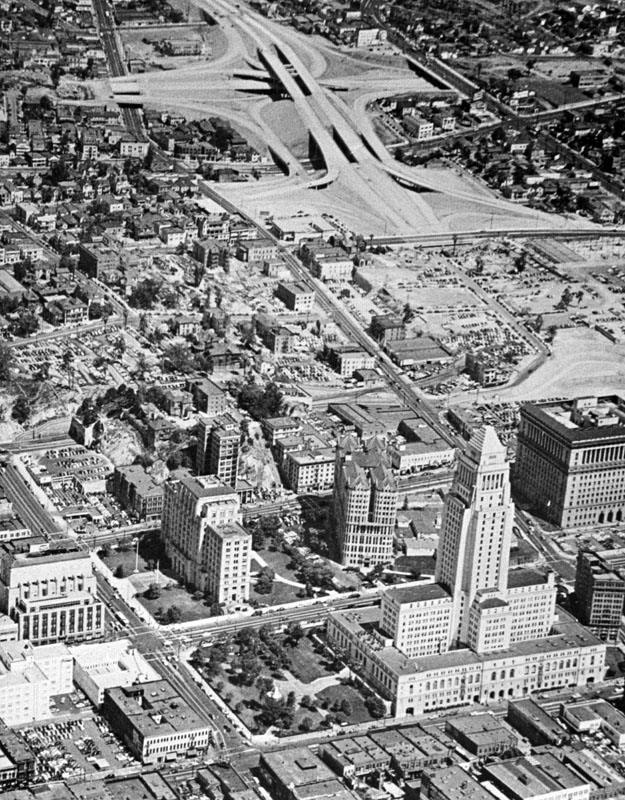
| (1949)* - Aerial view showing the construction of the Four Level Interchange (top of photo). Note that Bunker Hill is still covered with apartment buildings and houses. |
Historical Notes Construction of the Four Level Interchange—completed in 1949 and opened fully in 1953—marked the beginning of the freeway era in Los Angeles. It was the first stack interchange in the world and became a model for modern highway engineering. Despite the growing freeway network nearby, Bunker Hill remained largely residential at this time, though change was fast approaching. |
 |
|
| (1951)* – View looking northwest from the top of the Hall of Records showing Bunker Hill as it appeared in the early 1950s. The Four Level Interchange is under construction at center-right. Parking lots fill spaces where older apartment houses once stood. Court Street runs at left, and the intersection of Temple and Hill streets is at lower-right. The Hollywood Hills and Hollywood Sign can be seen in the distance. |
Historical Notes By the early 1950s, parts of Bunker Hill had already begun to empty out. The area’s aging housing stock and steep streets made it difficult to maintain. Over the next decade, the hill would be leveled as part of an ambitious urban renewal program, making way for the expansion of the Civic Center, the Music Center, and the Department of Water and Power’s General Office Building. |
 |
|
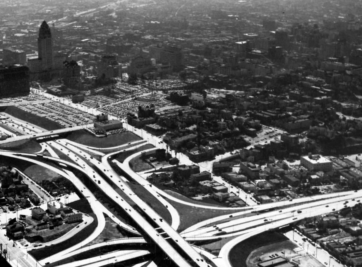
| (1954)* - Aerial view looking southeast over the newly constructed Four Level Interchange showing Bunker Hill (center-right), future home of both the DWP General Office Building and the Music Center. |
Historical Notes Completed in 1949 and fully opened in 1953, the Four Level Interchange connected U.S. Route 101 (Hollywood Freeway and Santa Ana Freeway) with State Route 110 (Harbor Freeway and Arroyo Seco Parkway). Its completion marked a turning point for downtown mobility, opening access to the Civic Center and paving the way—literally and figuratively—for large-scale redevelopment on Bunker Hill. |
 |
|
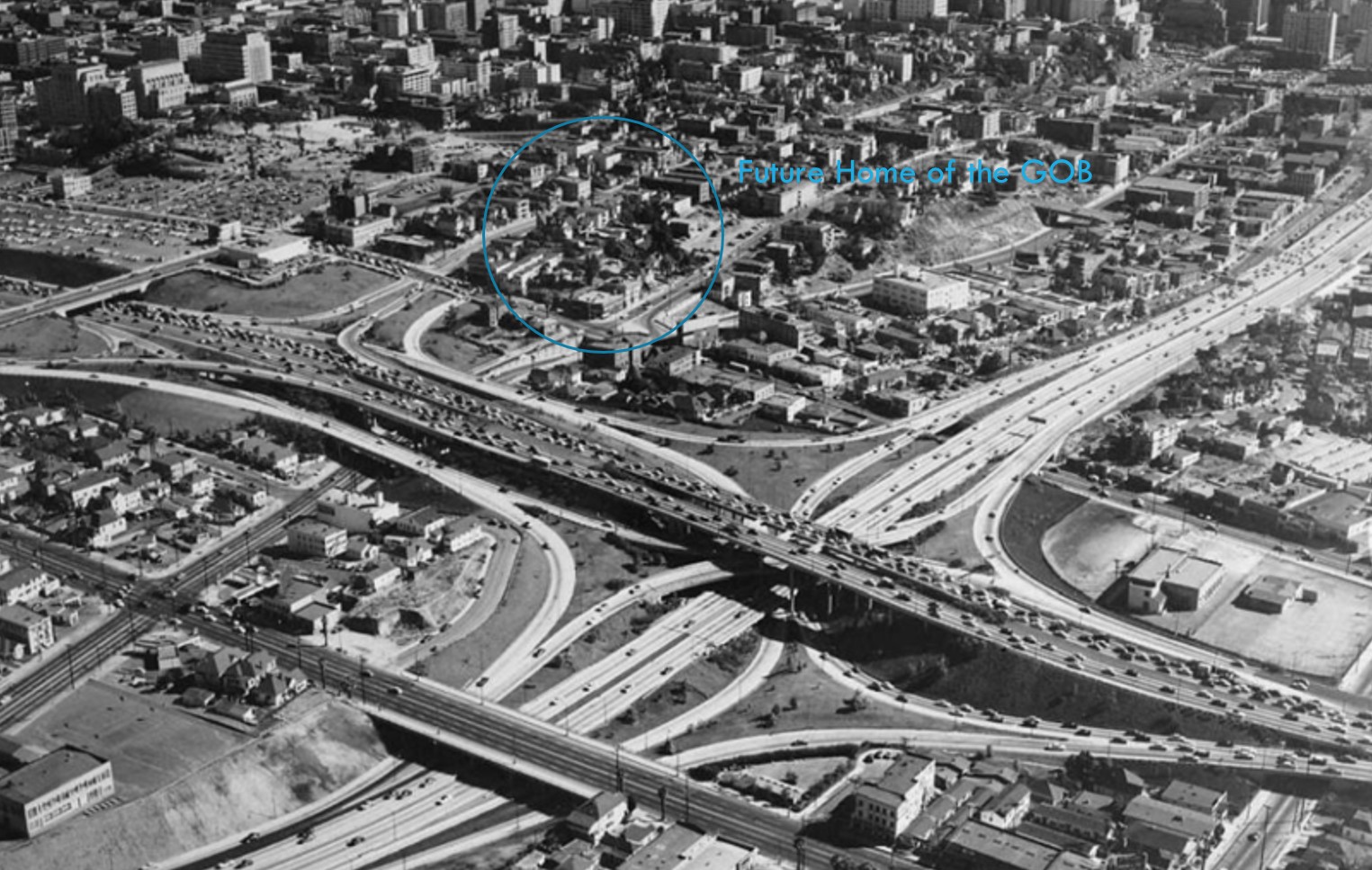
| (1954)* - Aerial view looking southeast across the Four Level Interchange and Bunker Hill showing the future site of the Department of Water and Power’s General Office Building. |
Historical Notes By 1954, the freeway system was complete around downtown, but Bunker Hill had yet to be cleared. Rows of apartments and houses still filled the area that would soon become home to the DWP’s General Office Building and the Los Angeles Music Center. This image captures the brief moment between the end of the freeway era’s construction and the start of the city’s major urban renewal phase. |
 |
|
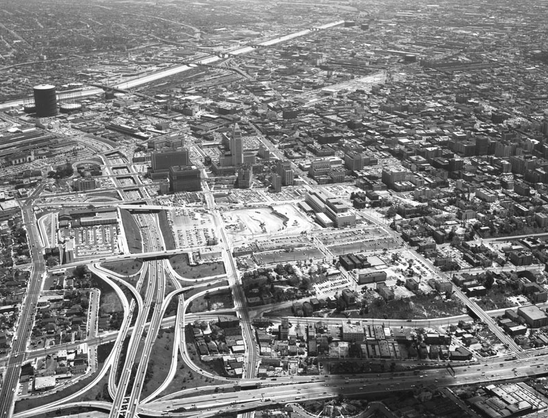
| (1957)* - Aerial view of the Los Angeles Civic Center looking east. The Hollywood Freeway (101) is visible on the left, City Hall is at the center, the Los Angeles River runs along the top, and the Harbor Freeway (110) crosses the bottom. The street running from the lower center to the top is Temple Street. |
Historical Notes At center, the construction site between Hill, Temple, Grand, and First streets would soon become the Los Angeles County Superior Court Building. Just below it, the future sites of the Dorothy Chandler Pavilion and the Ahmanson Theatre can be seen. Across Hope Street, the southern slope of Bunker Hill remains covered with apartment buildings and houses—soon to be cleared for the DWP’s new General Office Building. |
* * * * * |
Bunker Hill, Music Center, & DWP GOB
 |
|
| (1958)* - Aerial view of downtown Los Angeles looking south from the intersection of Sunset and Figueroa. In the left-center of the photo, Hope Street runs between First and Temple streets, where both the Department of Water and Power’s General Office Building (GOB) and the Music Center would soon rise. |
Historical Notes By 1958, preparation for the redevelopment of Bunker Hill was underway. The once-vibrant residential neighborhood—filled with Victorian homes and small apartment buildings—was being vacated and cleared as the city prepared for new civic and cultural landmarks. Within a decade, this area would be home to the Music Center, the County Courthouse, and the DWP’s iconic General Office Building—symbols of modern Los Angeles’ postwar identity. |
 |
|
| (1958)* - Annotated aerial view of Bunker Hill showing the future sites of DWP’s General Office Building and the Music Center. Annotated by Jack Feldman. |
Historical Notes This annotated view pinpoints the heart of Los Angeles’ urban renewal program. The shaded area marks where the Department of Water and Power’s General Office Building (later renamed the John Ferraro Building) and the Music Center complex—including the Dorothy Chandler Pavilion, Ahmanson Theatre, and Mark Taper Forum—would soon stand. At this time, most of the original Bunker Hill structures were still standing, though demolition had begun in sections closest to the Civic Center. The transition from aging residences to grand civic architecture represented not only a physical transformation but also a shift in the city’s self-image—from a Western town to a modern metropolis defined by culture, government, and design innovation. |
Before and After
 |
|
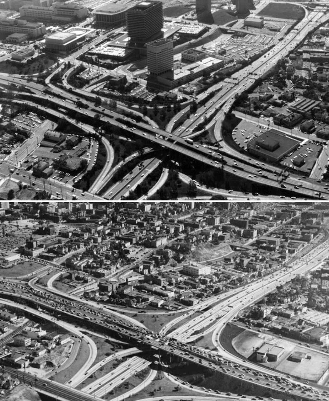
| (1954 vs. 1970)* - Aerial view looking southeast over the Four Level Interchange showing how Bunker Hill was transformed from a residential neighborhood into a modern civic center. Photo comparison by Jack Feldman. |
Historical Notes In 1954, Bunker Hill was still filled with turn-of-the-century houses, small hotels, and rooming houses that had once been among the finest addresses in Los Angeles. By 1970, nearly all had vanished, replaced by wide boulevards, office towers, and new civic landmarks. The DWP’s General Office Building and the Music Center symbolized a new downtown—clean, modern, and built for the automobile age. This view shows how urban renewal reshaped the city’s physical and social landscape in just sixteen years. |
Before and After
.jpg) |
|
| (1954 vs. 1970)* - Aerial view looking southeast over the Four Level Interchange showing the growth of Los Angeles’ Civic Center skyline during the postwar building boom. |
Historical Notes Between 1954 and 1970, downtown Los Angeles underwent one of the most dramatic skyline changes in its history. The Four Level Interchange, completed in 1949, became a gateway to a rapidly developing civic center. By 1970, the once-empty slopes of Bunker Hill had given rise to the John Ferraro Building (DWP), the Dorothy Chandler Pavilion, and the Ahmanson Theatre. City Hall, once standing alone, was now surrounded by symbols of the city’s growing political, cultural, and economic strength. |
Before and After
.jpg) |
|
.jpg) |
|
| (1954 vs. 1970)* - Aerial view looking southeast over the Four Level Interchange showing Bunker Hill’s transformation from a working-class neighborhood into the city’s civic and cultural heart. |
Historical Notes In the mid-1950s, Bunker Hill remained a fading residential district overlooking the Civic Center. Redevelopment cleared the area in the late 1950s, and by 1970 the hill had been completely reshaped. The new Department of Water and Power Building, Music Center, and County Courthouse redefined the city’s western skyline and shifted downtown’s focus from industry and housing to government and culture. The contrast between these two eras captures Los Angeles’ ongoing quest for modernization and identity. |
Then and Now
 |
|
 |
|
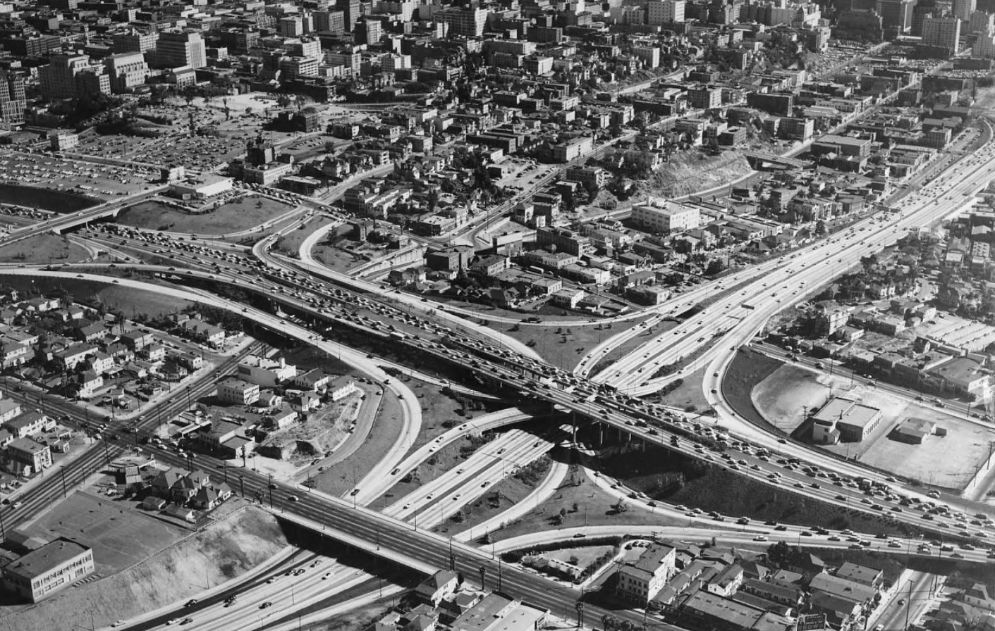
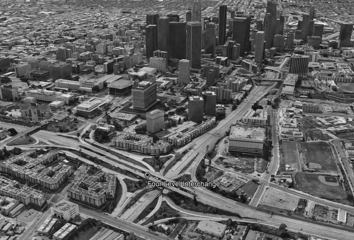
| (1954 vs. 2020)* - A Then and Now view of Bunker Hill, the Four Level Interchange, and the Downtown Skyline. Photo comparison by Jack Feldman. |
Historical Notes Nearly seventy years separate these views. In the early 1950s, Bunker Hill was still a dense residential district of aging homes and rooming houses overlooking the Civic Center. By 2020, the area had been transformed into a vibrant urban core anchored by the Music Center, Walt Disney Concert Hall, and the DWP’s John Ferraro Building. The once-steep hillside had become a plateau of culture, architecture, and civic pride—reflecting Los Angeles’ mid-century vision of progress. |
Then and Now
 |
|
| (1954 vs. 2023)* - A Then and Now view of Bunker Hill, the Four Level Interchange, and the Downtown Skyline. Photo comparison by Jack Feldman. |
Historical Notes Almost seventy years after redevelopment began, the transformation of Bunker Hill continues. The 1954 photo captures a neighborhood on the brink of demolition, filled with narrow streets and Victorian homes. The 2023 view reveals an evolving skyline—where new residential towers and cultural venues rise beside enduring landmarks like the DWP Building and Music Center. What began as postwar urban renewal has matured into a dynamic cityscape that still reflects Los Angeles’ ongoing reinvention. |
Then and Now
 |
|
| (1957 vs. 2023)* - Aerial view comparison looking southeast showing the changing skyline of the Civic Center and Bunker Hill. Photo comparison by Jack Feldman. |
Historical Notes The contrast between these two views illustrates the transformation of downtown Los Angeles from a low-rise civic core surrounded by residential neighborhoods into a dense urban landscape of steel and glass. The changes mirror the city’s growth from a regional center into a major international metropolis. Much of this transformation began with the clearance of Bunker Hill in the late 1950s, making way for redevelopment that continues even today. |
* * * * * |
Bunker Hill Parking
 |
|
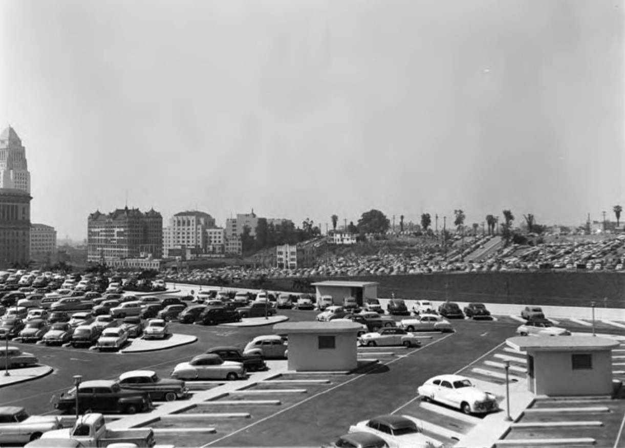
| (1954)* - View looking southeast showing Bunker Hill and a portion of Los Angeles civic center. Note how most of the buildings on Bunker Hill have been removed and replaced by parking lots. |
Historical Notes Within just a few years of the above photo, Bunker HIll would undergo a major transformation. The hill would be graded to make room for the new Civic Center expansion which would inlcude the construction of new City and County buildings, the Dorothy Chandler Pavilion, Ahmanson Theatre, and the Department of Water and Power Building. |
 |
|
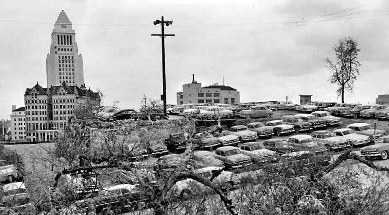
| (ca. 1954) - Bunker Hill parking lot with the Hall of Records and City Hall in the background. |
Historical Notes The abundance of parking lots in the early 1950s marks a transitional phase between the older residential character of Bunker Hill and the massive redevelopment projects that began later in the decade. These parking lots served as temporary placeholders, indicating land already earmarked for more substantial changes. |
* * * * * |
Bunker Hill (1956 - 1970)
 |
|
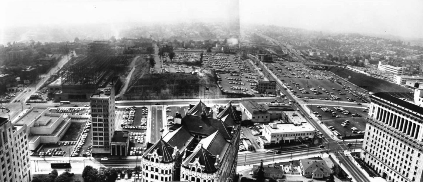
| (1956)** - Panoramic photograph composite taken from the City Hall tower, facing west to northwest towards Bunker Hill and Hollywood. Bunker Hill has been slightly shaved off to make room for the County Courthouse, which is under construction, as well as several parking lots. There are still a few remaining dwellings at the far end of Bunker Hill. | Broad |
 |
|
| (ca. 1960)^^^ - View looking n/w from City Hall toward Bunker Hill prior to construction of the GOB and Music Center. |
 |
|
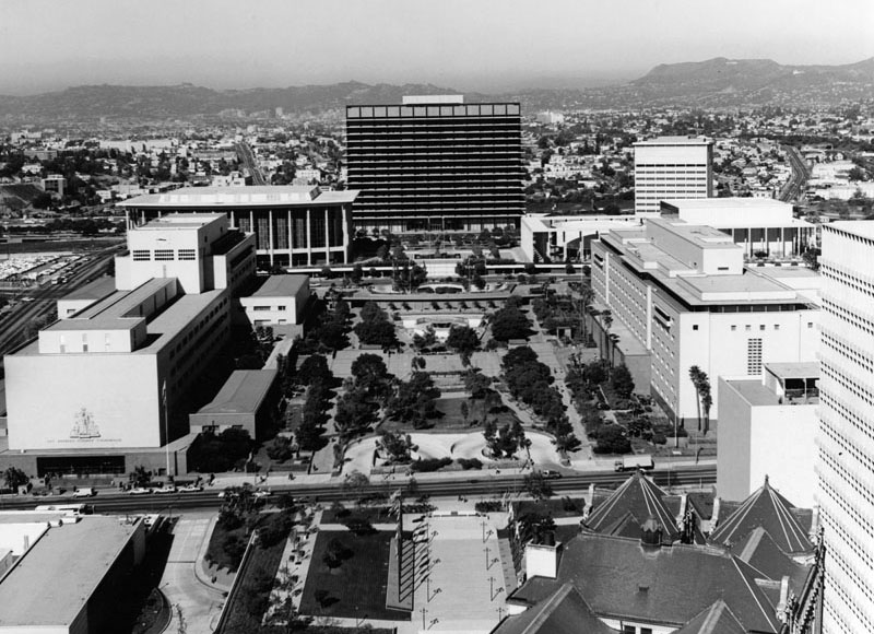
| (ca. 1970)^^^ - View of from City Hall looking northwest after construction of the GOB and Music Center. |
* * * * * |
Before and After
 |
|
| 1960 vs. 1970 |
 |
|
| 1960 vs. 1970 |
* * * * * |
Bunker Hill Changing Skyline
 |
|
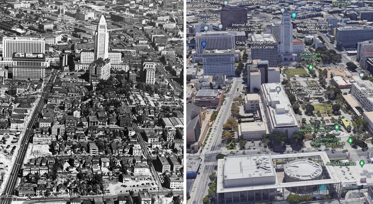
| (1945 vs. 2022) - Aerial view over Bunker Hill looking east toward the Los Angeles Civic Center. Temple Street is on the left running away from the camera. |
Before and After
.jpg) |
|
.jpg) |
|
| (1954)* vs. (1970)* |
Then and Now
 |
|
 |
|
| (1954 vs 2022)* - Then and Now |
* * * * * |
Then and Now
 |
|
| (1959 vs 1966) - View showing the Basserman home (left) located on Bunker Hill at the current location of the Water and Power Building (John Ferraro Office Building). |
* * * * * |
Post GOB Construction
 |
|
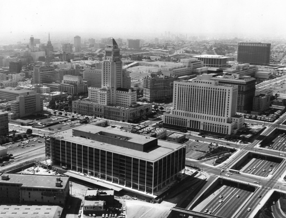
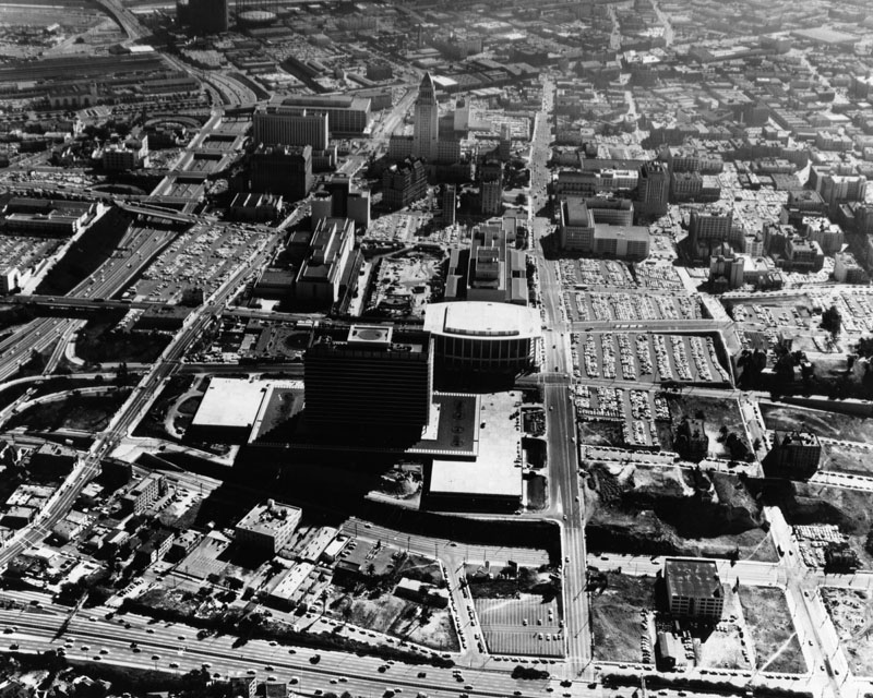
| (ca. 1965)^# – View of the Los Angeles Civic Center looking southwest showing the DWP General Office Building located on Bunker Hill in the upper-right corner. |
 |
|
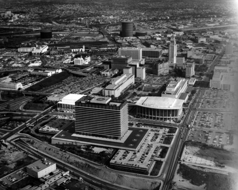
| (ca. 1965)* - Aerial view looking east toward the Water and Power building (mid-photo), the Music Center directly behind it (white roof), L.A. County Courthouse (rectangular building), and City Hall at the upper middle portion of the photo. First Street is to the right of the Music Center, Temple Street is to the left, with the 101 Hollywood Freeway parallel to it, and the 110 Harbor Freeway along the bottom of the photo. It appears that the Ahmanson Theatre is still under construction. The theatre opened on April 12, 1967. |
 |
|
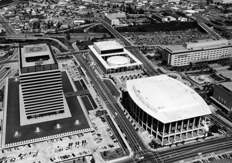
| (1968)**- Aerial view of LADWP's General Office Building with LA Civic Center in the background. |
 |
|
| (n.d.) - An aerial shot of the Music Center and the Department of Water and Power Building. |
 |
|
| (1967)* - View of Department of Water and Power building on the left and Dorothy Chandler Pavilion on the right as seen from a parking lot across First Street (location of today's Disney Hall). |
Historical Note The parking lot seen above is the current site of the Walt Disney Concert Hall (built between 1999 and 2003). |
 |
|
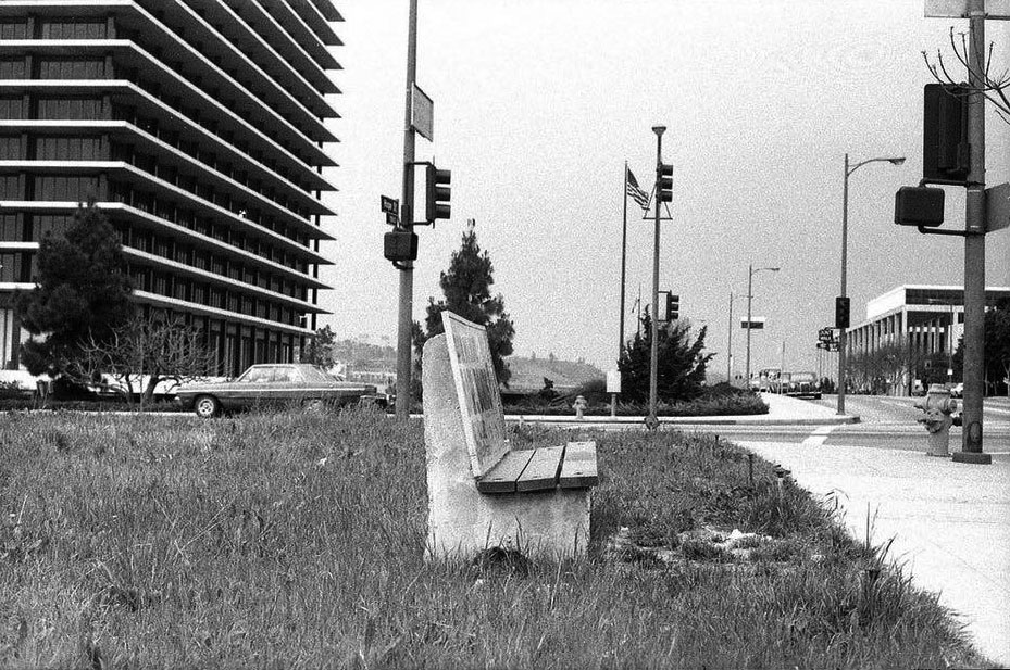
| (ca. 1967)^ – View looking north as seen from the SW corner of 1st and Hope streets with the DWP Building at left and the Dorothy Chandler Pavilion in the distance on the right. |
 |
|
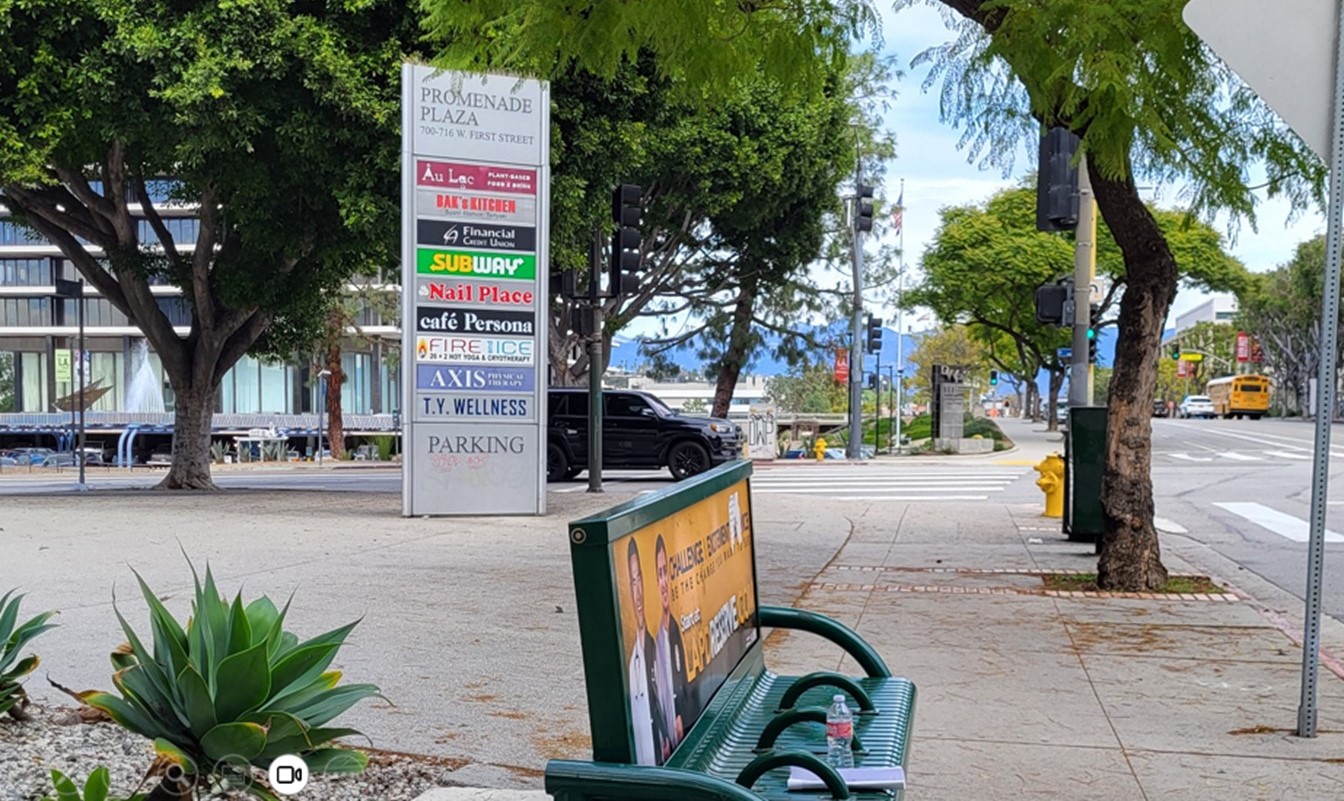
| (2024) – View looking north as seen from the SW corner of 1st and Hope streets with the DWP Building at left and the Dorothy Chandler Pavilion in the distance on the right. Photo by Jack Feldman |
Then and Now
 |
|
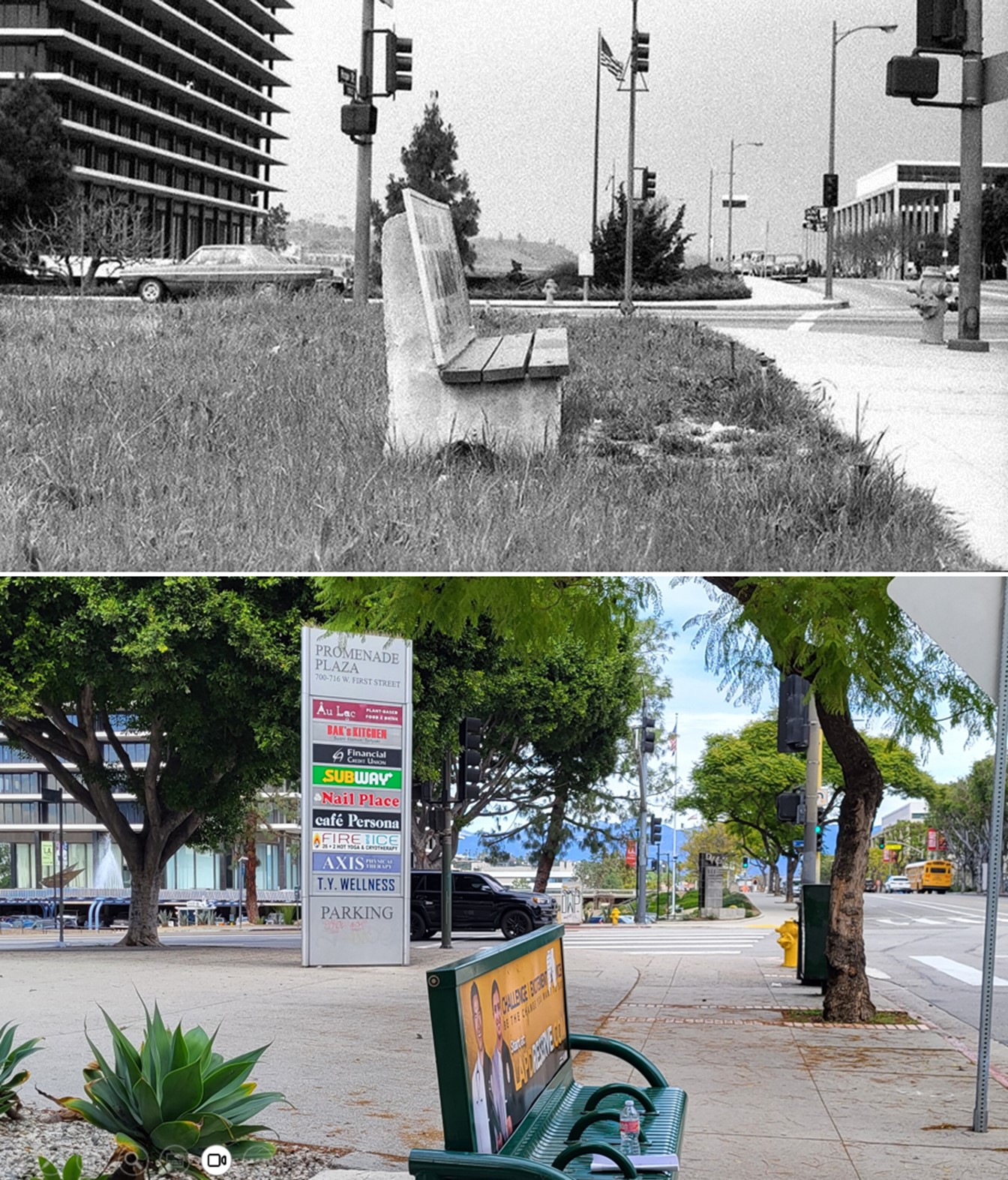
| (1967 vs 2024) – View looking north as seen from the SW corner of 1st and Hope streets with the DWP Building at left and the Dorothy Chandler Pavilion in the distance on the right. Contemporary photo by Jack Feldman |
 |
|
| (1967)* - Composite panoramic photo taken from the 5th floor of the DWP Building. The view is looking south at Bunker Hill. Hope Street is at left with Flower Street at center. Note the parking lots in left foreground. This is where Bunker Towers and Disney Hall stand today. |
 |
|
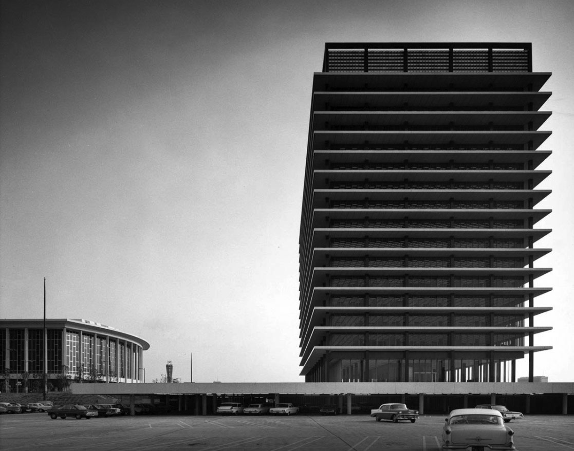
| (1960s)* – View looking south showing the DWP Building with the Dorothy Chandler Pavilion seen in the left background as seen from the customer service parking lot. Photo by Julius Shulman |
* * * * * |
JFB's Iconic 'Floating Staircase'
 |
|
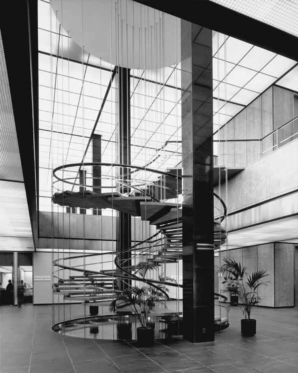
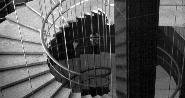
| (1965)^* - Interior view of the GOB showing the spiral staircase leading up to the main lobby from one of the lower floors. |
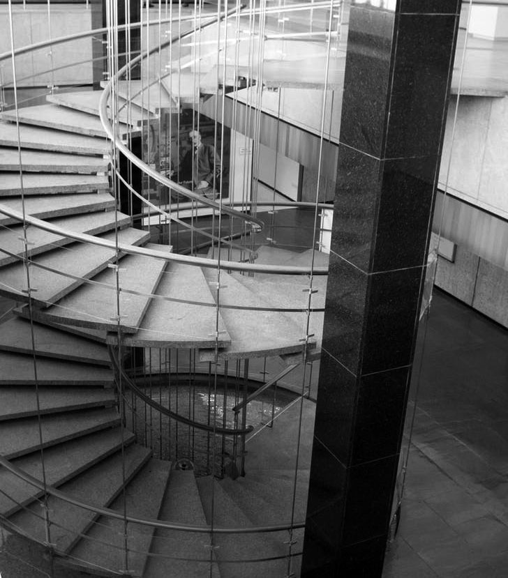
Historical Notes The building’s main lobby is impressive in its own right, two stories high and graced by a huge spiral staircase that seems to float in the air. Architectural historian Reyner Banham described the DWP headquarters as “the only public building in the whole city that genuinely graces the scene and lifts the spirit (and sits in firm control of the whole basis of human existence in Los Angeles).” |
 |
|
| (ca. 1965)^.^ – View looking down the spiral staircase connecting the main lobby to the lower A-level at the Water and Power Building. |
 |
|
| (2018)* - View showing the JFB spiral staircase as it appears today. Note the large portrait of William Mulholland at bottom of staircase. Photo by Patrick Geske |
Historical Notes The John Ferraro Building features an iconic "floating" spiral staircase in the main lobby. The staircase connects the two-story main lobby with a lower floor, and a circular basin of water emphasizes the bottom of the staircase. This striking architectural feature was designed by the firm of A.C. Martin and Associates as part of the building's overall International Style aesthetic. |
 |
|
| (1965)^^ - Evening view showing the front of the DWP Office Building with lights and fountains on, as seen from the Music Center across the street. |
 |
|
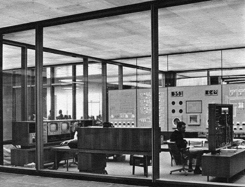
| (1965)* - View showing the operations room where the building’s electrical and mechanical equipment is controlled from. |
 |
|
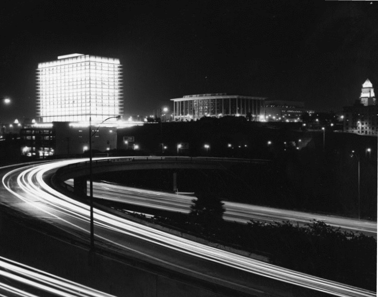
| (1965)* - Civic center buildings at night; left to right, the Department of Water and Power GOB, Music Center and City Hall, seen from across the Harbor Freeway. |
.jpg) |
|
| (ca. 1970)* - Panoramic postcard view looking east from Beaudry Avenue toward the 110 Freeway, showing the Los Angeles Department of Water and Power GOB, Dorothy Chandler Pavilion, and Los Angeles City Hall. |
 |
|
| (1969)**^ – View looking north showing the Harbor Freeway running through downtown Los Angeles. In the distance can be seen the new Department of Water and Power Building, Music Center, and City Hall. |
 |
|
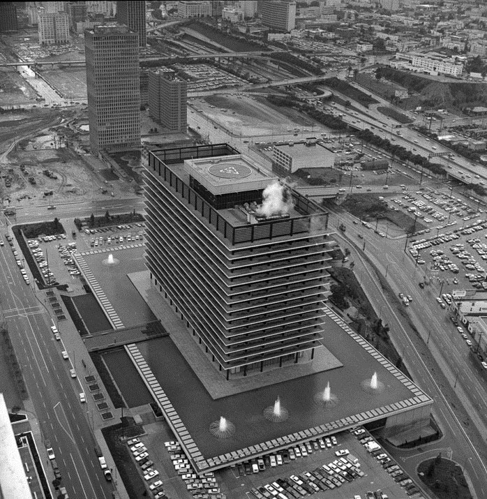
| (1969)* - Air view of the General Office Building and area. General Office Building. The office building is a 17-story multipurpose facility containing a 2,300 car subterranean parking structure. The building was constructed with a concrete and steel frame, which supports precast concrete exterior walls. |
Historical Notes After almost five decades since its construction, the building is still recognized as one of Los Angeles' most iconic structures. |
 |
|
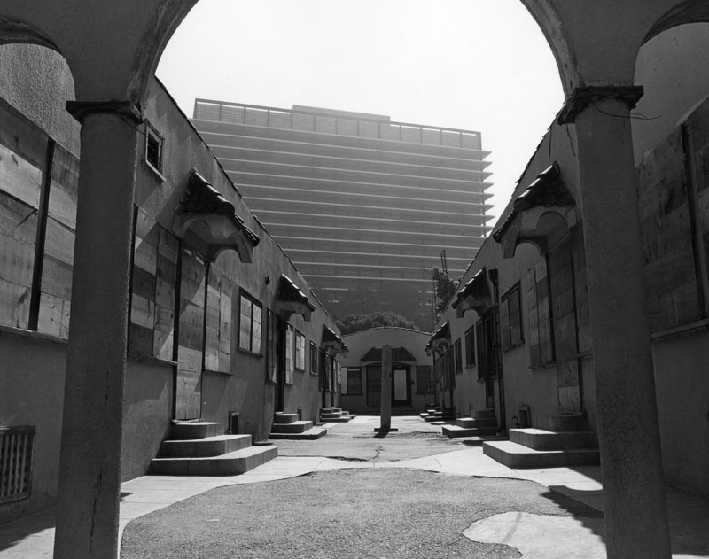
| (1979)* - Boarded-up bungalow court apartments on Fremont near Temple Avenues. The Department of Water and Power general office building is behind. |
* * * * * |
Changing Downtown Skyline as seen from the GOB
 |
|
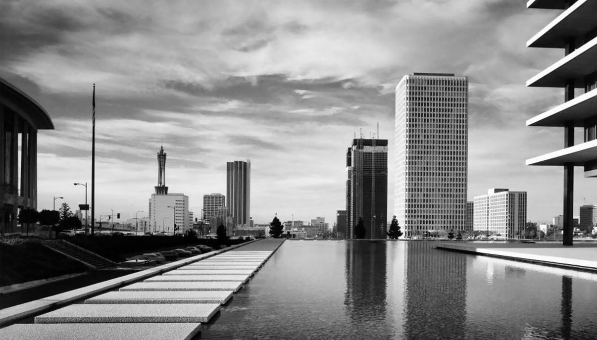
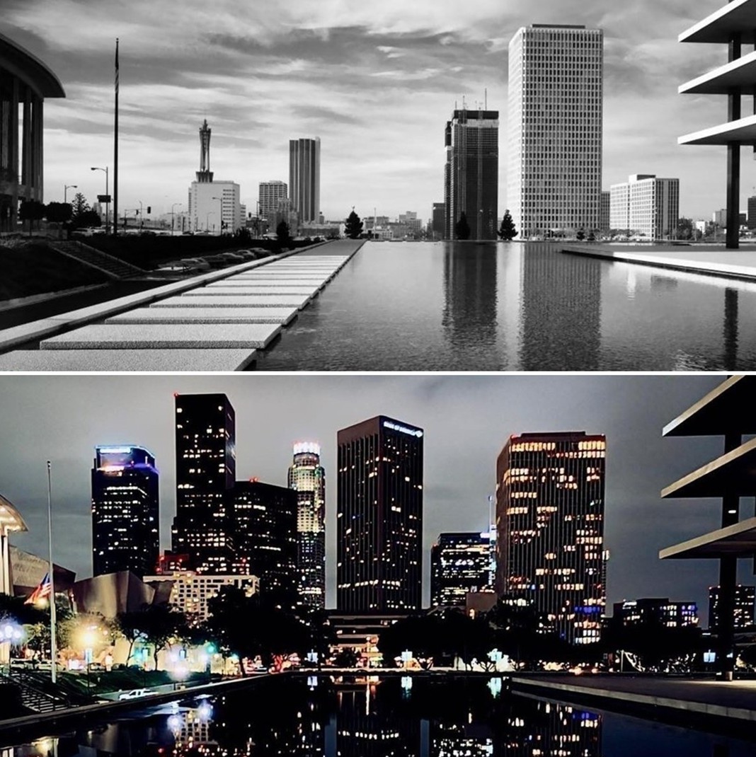
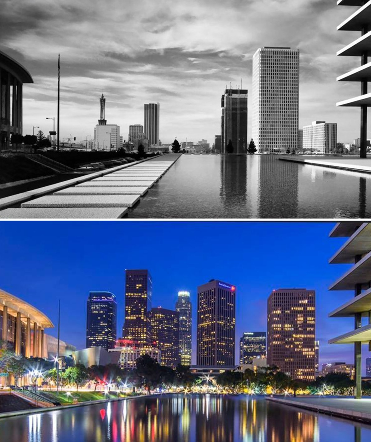
| (1971)* - View looking south from the front entry ‘bridge’ to the Water and Power Office Building, with the ARCO Plaza twin towers under construction in the distance (photo by Julius Schulman). |
Historical Notes In this view, Los Angeles was still in a phase of emergent vertical growth. The twin ARCO Plaza towers (later renamed City National Plaza) were completed in 1972, and here you see their skeletal forms just becoming dominant in the downtown skyline. Julius Schulman, a legendary architectural photographer, captured many vistas of mid-century Los Angeles including this transitional moment. At this time, the Bunker Hill area was undergoing major change: the city’s redevelopment scheme had already acquired many of the older Victorian-era buildings, and plans were underway to reimagine the hill as a modern commercial and civic district. |
 |
|
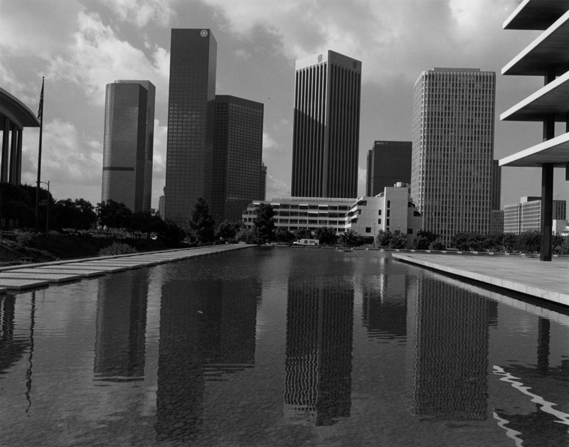
| (1986)* - Looking south from the water courtyard of the General Office Building of the Department of Water and Power. |
 |
|
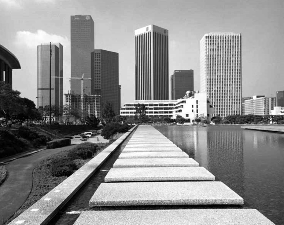
| (1988)* - View looking south across the concrete pads that surround the JFB's water courtyard towards an ever changing downtown skyline. Photo by William Reagh |
 |
|
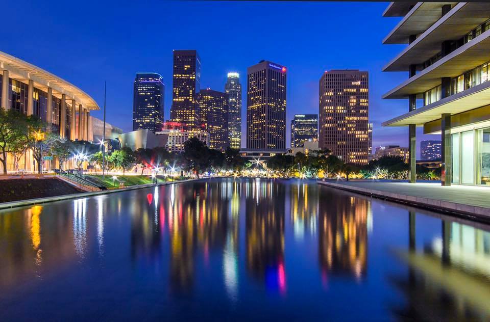
| (2019)* - Contemporary view from the same front entry ‘bridge’ into a greatly transformed skyline (photo by Tom Awai). |
Historical Notes By 2019 the skyline has shifted dramatically. The ARCO Plaza towers (today City National Plaza) remain, but many more high-rise buildings and mixed-use towers have joined the cluster. In the decades since the 1970s, Bunker Hill has become a focal point for downtown revitalization. The area saw construction of the Music Center, cultural institutions, and new office and residential towers. Many older buildings were demolished to make way for modernist and postmodern architecture, reshaping the visual identity of L.A. This view demonstrates how the original central cores have been complemented, and in some cases overshadowed, by newer structures that reflect evolving architectural trends and zoning policies. |
 |
|
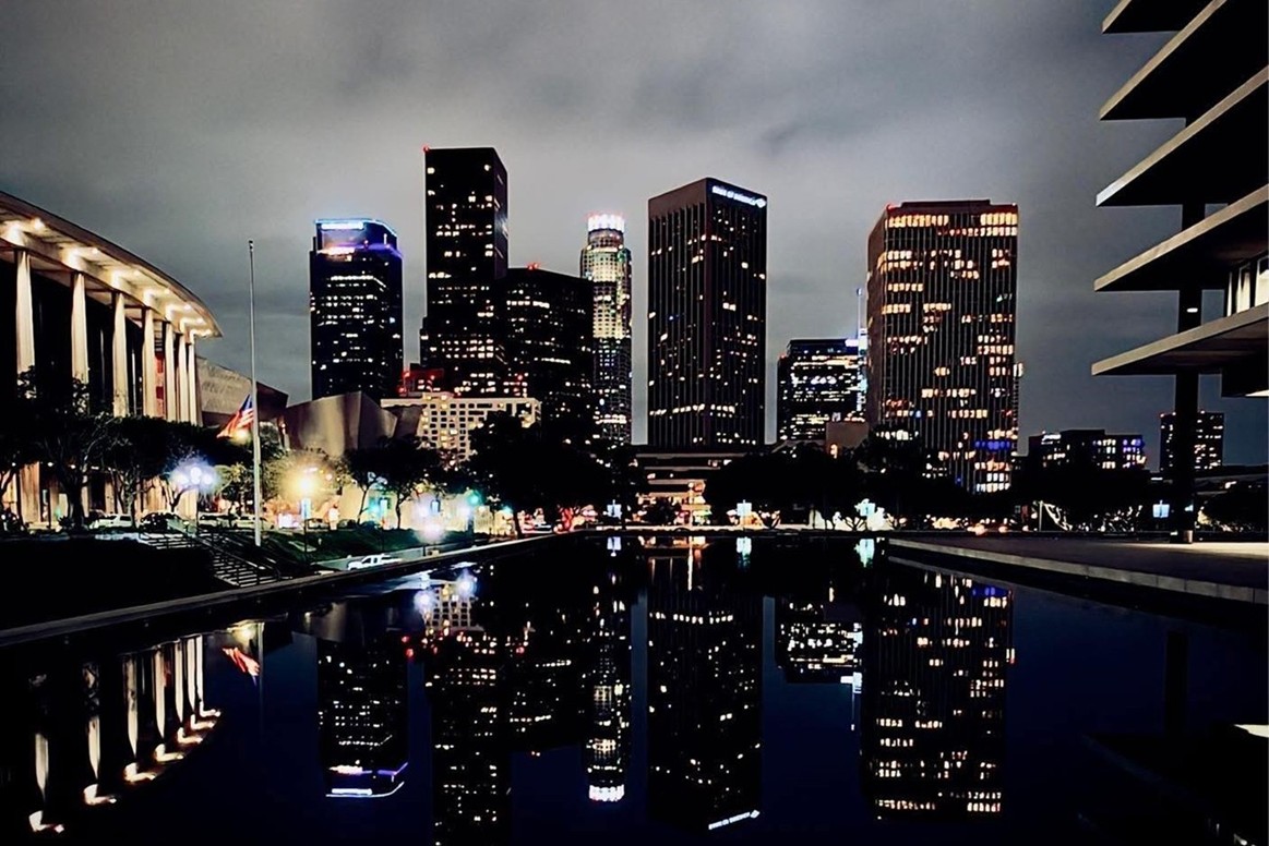
| (2025)* - Current view from the DWP bridge entrance, framing today’s dense and layered Bunker Hill skyline (photo by Carlos G. Lucero). |
Historical Notes This vantage shows how Bunker Hill now epitomizes the vertical and mixed-use ambitions of 21st-century downtown Los Angeles. New towers continue to climb, filling gaps left in earlier phases of redevelopment. From this fixed vantage, you can trace how the skyline densified upward, with each new building adding a different layer to the evolving silhouette of Bunker Hill. |
Then and Now
 |
|
| (1971 vs 2025)* - Paired view south toward the Bunker Hill skyline from the DWP front entry bridge (photo comparison by Jack Feldman). |
Historical Notes This juxtaposition underscores a profound transformation over 54 years. In 1971, the skyline was nascent—towers rising amid more open lots and low structures. By 2025, the skyline is contiguous, dense, and sculpted. Behind this change lies the longest redevelopment project in Los Angeles history, begun in the 1950s and continuing for decades. The project sought to clear what some city planners then considered “blighted” areas, displacing many older residents and buildings to make way for a modern corporate, cultural, and civic hub. While some lament the erasure of old Bunker Hill’s character, the current skyline also embodies Los Angeles’s ambitions to be a world-class downtown. |
Then and Now
 |
|
| (1971 vs 2019)* - Comparative view looking south toward Bunker Hill from the DWP bridge (photo comparison by Jack Feldman). |
Historical Notes This pairing shows the intermediate stage of transformation. By 2019 many of the major towers had already risen, but further infill and densification would still occur. Between these two years many projects—cultural institutions, residential towers, and public realm works—contributed to a sustained momentum of change downtown. The contrast highlights how incremental phases of development accumulate into a distinct skyline identity. |
* * * * * |
 |
|
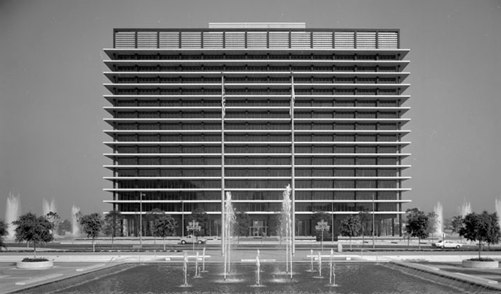
| (ca. 1967)* - View showing the GOB as seen from behind the Music Center fountains across the street. |
 |
|
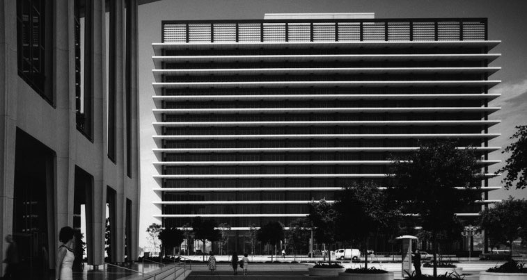
| (ca. 1970)* – View looking west toward the Water and Power Building as seen from the front of the Dorothy Chandler Pavilion. |
 |
|
| (ca. 1970)* - Panoramic night view looking west toward the DWP building as seen from in front of the Dorothy Chandler Pavilion. |
 |
|
| (1984)* – Telescopic time-lapse photo showing moon over an illuminated DWP building with the Harbor Freeway in the foreground. Photo: James Ruebsamen / Los Angeles Herald Examiner |
 |
|
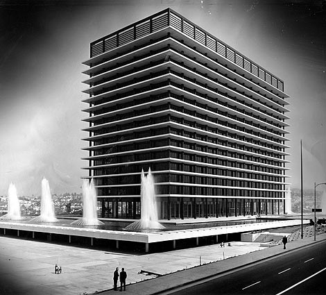
| View of John Ferraro Building with all eight fountains on. |
Historical Notes In November 2000, in honor of longtime council member John Ferraro, the General Office Building (GOB) was renamed the John Ferraro Building (JFB). John Ferraro (1924–2001) was the longest-serving Los Angeles City Council member in the history of the city—thirty-five years, from 1966 until his death in 2001—and the president of the council for fourteen of them. He had been an all-American football player at the University of Southern California. |
 |
|
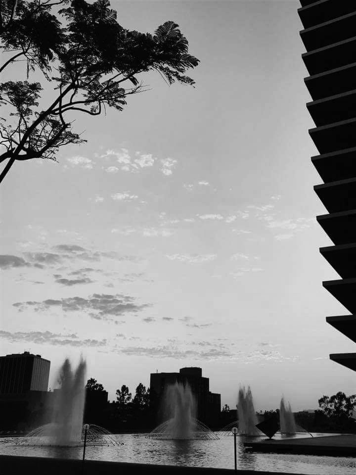
| (ca. 2016)* - View looking southwest showing the fountains with silhouette edge of the JFB on the right. The large diamond-shaped sculpture seen in the reflecting pool was a gift to Los Angeles from Italy in 1988. Photo by Takashi Onoe |
* * * * * |
Colpo d’ala Sculpture
 |
|
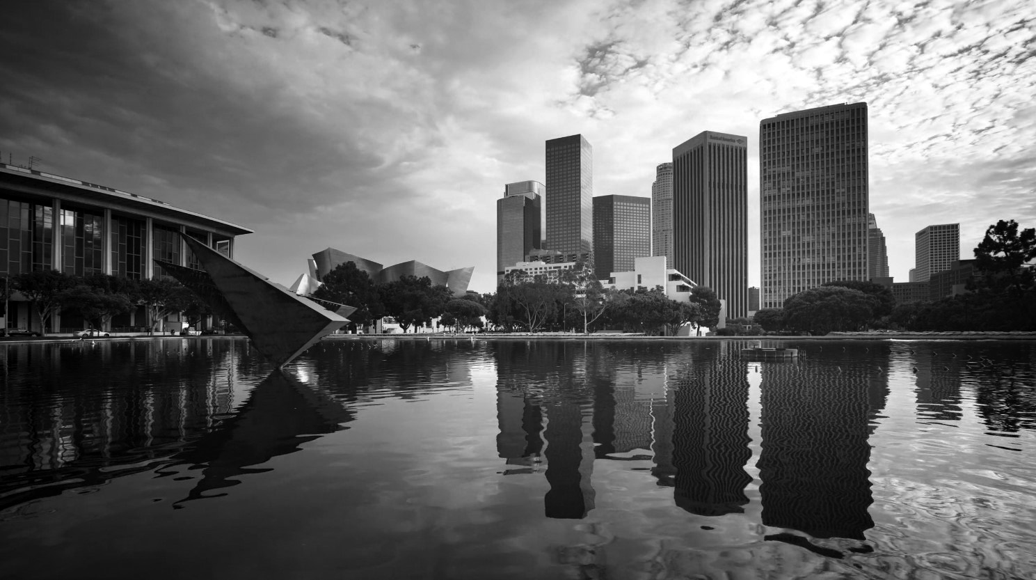
| (2019)* – Dusk view looking southeast from the south end walkway of the JFB toward the Downtown skyline. Dorothy Chandler Pavilion and the Disney Hall are seen at left in background with the DWP’s Colpo d’ala sculpture seen in the foreground. Photo by Miguel Rodriguez |
Historical Notes The sculpture seen above in the reflecting pool is called "Colpo d'ala"(wing-beat) by Arnaldo Pomodoro. It was donated to the U.S. as gratitude from Italy for assistance provided under the Marshall Plan. |
 |
|
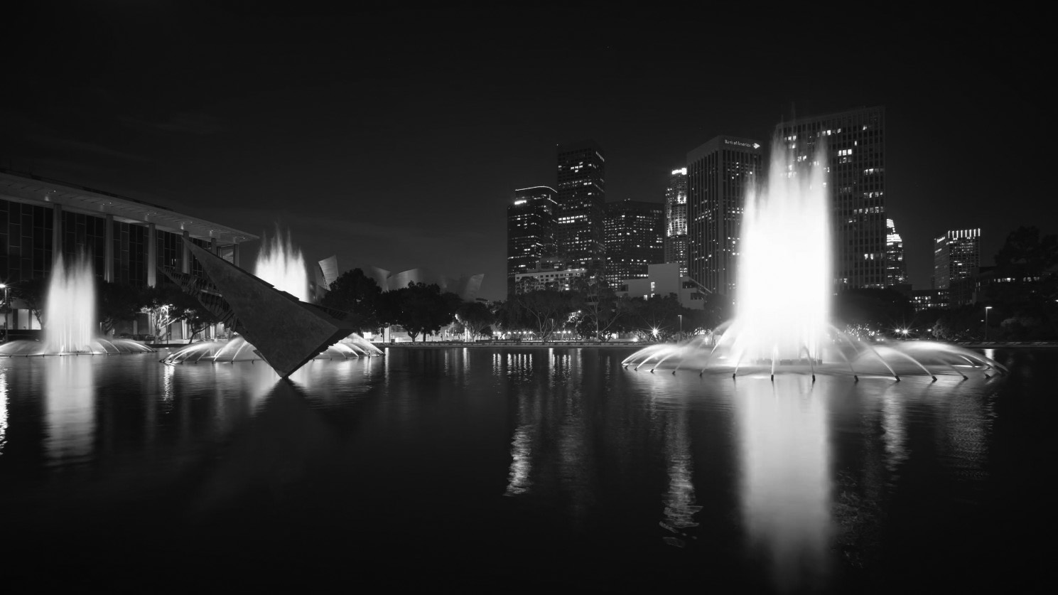
| (2019)* – Night view looking southeast from the south end walkway of the JFB toward the Downtown skyline. Dorothy Chandler Pavilion is at left with the DWP’s illuminated fountains and Colpo d’ala sculpture in the foreground. Photo by Miguel Rodriguez |
Historical Notes "Colpo d'ala"(wing-beat) by Arnaldo Pomodoro, is distinguished from other public monuments in downtown by remembering a national as well as an international endeavor. The Marshall Plan was an historic effort in which the United States, motivated by a mix of high-minded altruism and national self-interest, financed the restoration of Europe's war ravaged economies. In gratitude for the $1.5 billion Italy received between 1948 and 1952, Italian Prime Minister Ciriaco De Mita presented the six ton bronze sculpture to the United States on December 12, 1988 at dedication ceremonies commemorating the 40th anniversary of the Marshall Plan. Los Angeles was selected as the site for the gift because the city represents the "the model American city of the Space Age." |
 |
|
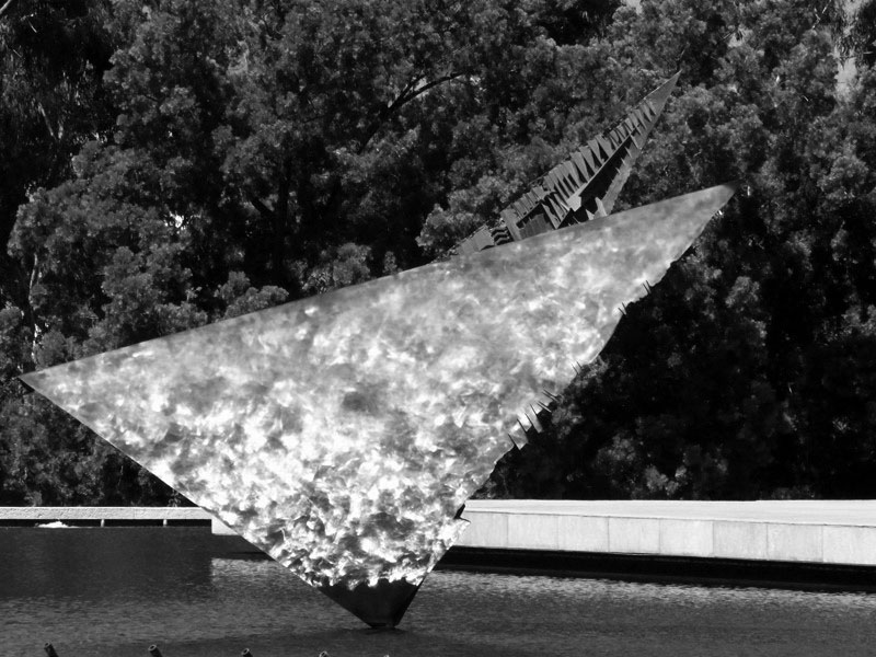
| (1988)* – Colpo d’ala, a sculpture by Arnalda Pomodoro, was installed in the pool’s southern end in 1988. It was a gift from the Italian Government. |
Historical Notes The Italian Government commissioned the gift less than six months before its unveiling. Pomodoro did not have time to design a new piece, so he offered "Colpo d'ala", which was already at the foundry. This sculpture is a larger version of "Colpo d'ala A Boccioni" commissioned in 1981 by the city of Morciano in homage of Umberto Boccioni(1882-1916), the prominent Italian Futurist who lived there. Both works harken back to Boccioni by combining the sense of mechanical force with the suggestion of movement. The sculpture, which is tilted upward like a bird beginning its assent, appears to be a highly polished triangular block ripped in half by a powerful invisible force, creating a "wing beat" shape. Pomodoro felt the reference to a bird, symbolizing the Marshall Plan's goals of peace and freedom, would be enhanced by placing the sculpture within a reflecting pool. A model of the piece was sent to Los Angeles to assist the city in finding an appropriate setting. After conducting structural tests on the roof of the Department of Water & Power garage, the Department of Public Works approved the location. Pomodoro oriented the sculpture, which can be rotated manually, to point west as a symbolic gesture to the connection between Los Angeles and the Pacific Rim. |
 |
|
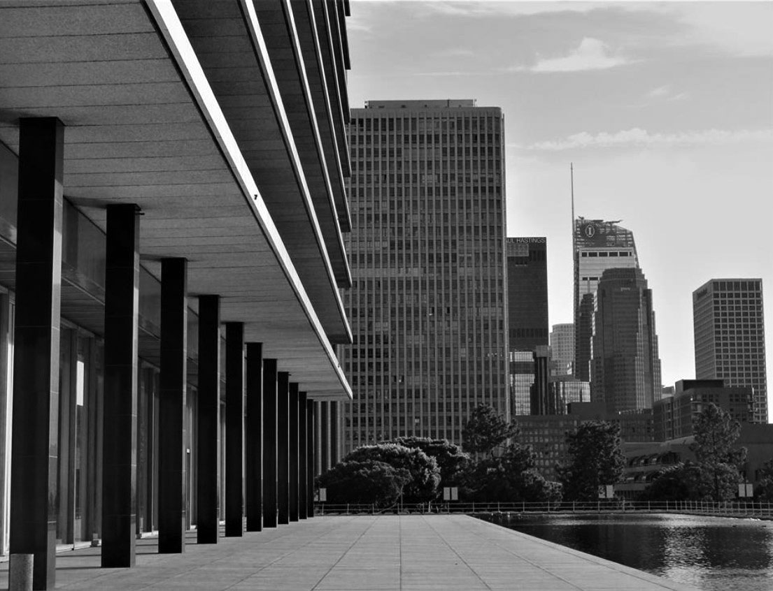
| (2019)^ – View looking south from the west end walkway between the JFB and its moat which surrounds the building. The 32-story Bunker Hill Tower (1968) stands directly across 1st Street. Also seen is the Westin Bonaventure Hotel (1976) and the 1,100 foot tall Wilshire Grand Center (2017). |
 |
|
| View showing a man on the concrete walkway between the building and the moat. Note the size of the building columns and cantilevered horizontal floor slabs.^ |
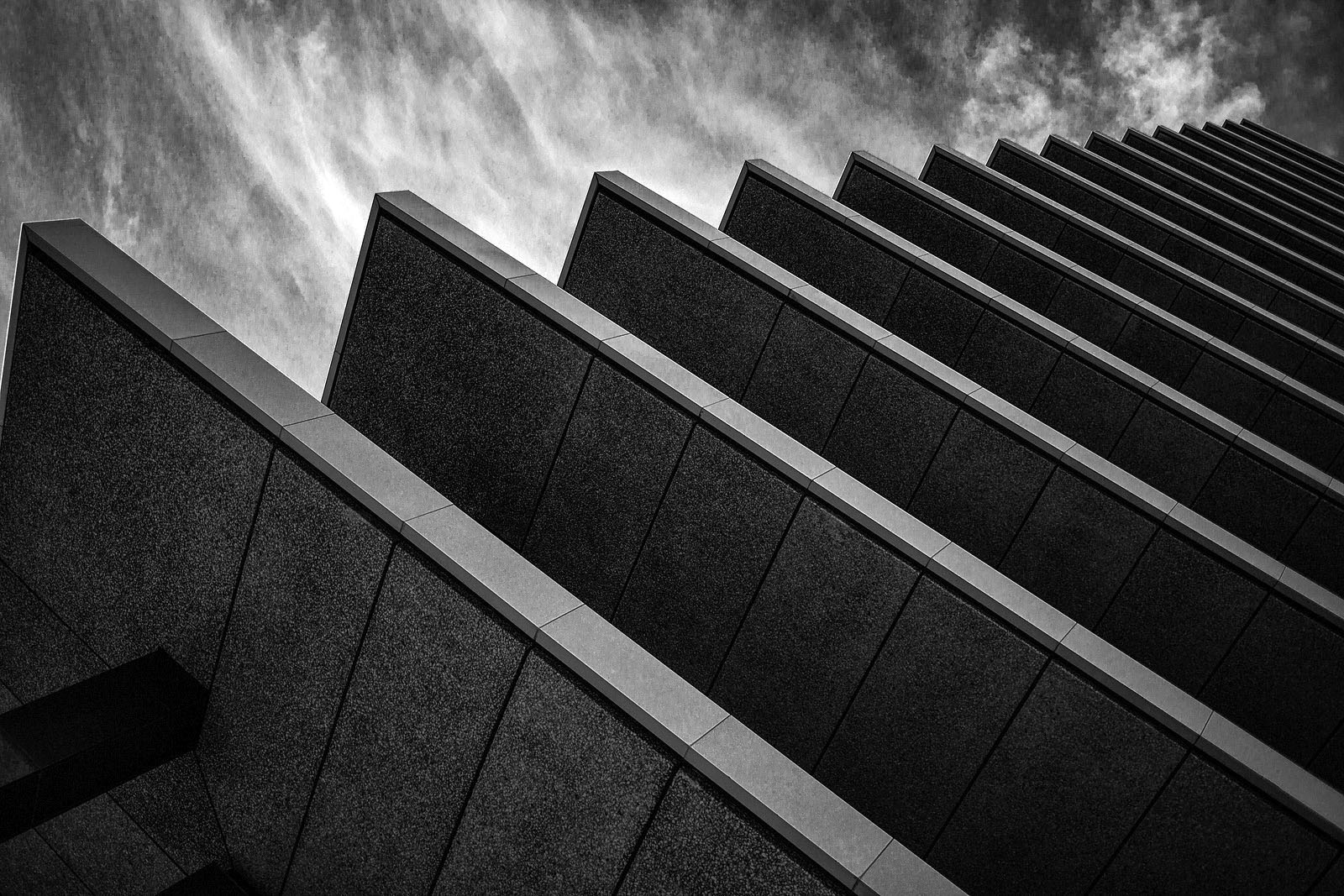
Historical Notes The building’s vertical steel columns support horizontal concrete floor slabs cantilevered twelve feet beyond the building, shading the office windows within and highlighting the structural system. |
 |
|
| (2019)* – Looking up to the top of the JFB showing the cantilevered floors slabs. Photo by Rick Smith |
 |
|
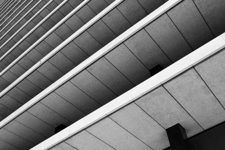
| (2018)* - Closer view of the cantilevered horizontal floor slabs which shade the office building. Photo courtesy of Patrick Geske |
Historical Notes At night, the horizontal elements are the only building components visible as the rest of it melts into a blaze of light, a shining lantern on the hill. |
 |
|
| (2018)* - View looking up at the JFB from the patio located at rear (west side) of the building. Photo courtesy of Patrick Geske |
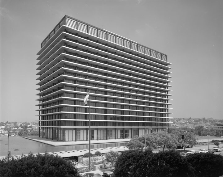 |
|
| The Los Angeles Department of Water and Power's Office Building (Referred to as the GOB or JFB).* View is looking northwest. |
Historical Notes On September 21, 2011, the John Ferraro Building was designated Los Angeles Historic-Cultural Monument No. 1022. |
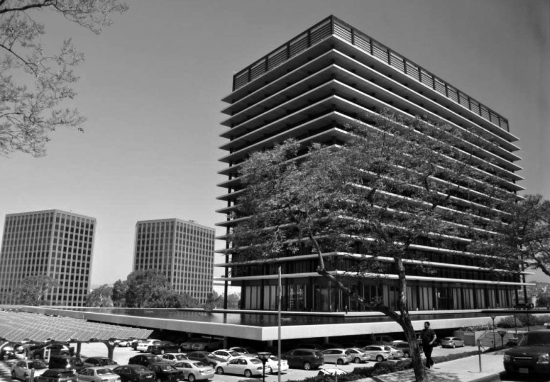 |
|
| (2014)*^ – View looking northwest showing the John Ferraro Building, home of the Los Angeles Department of Water and Power. Note the solar panels in the parking lot on the left. |
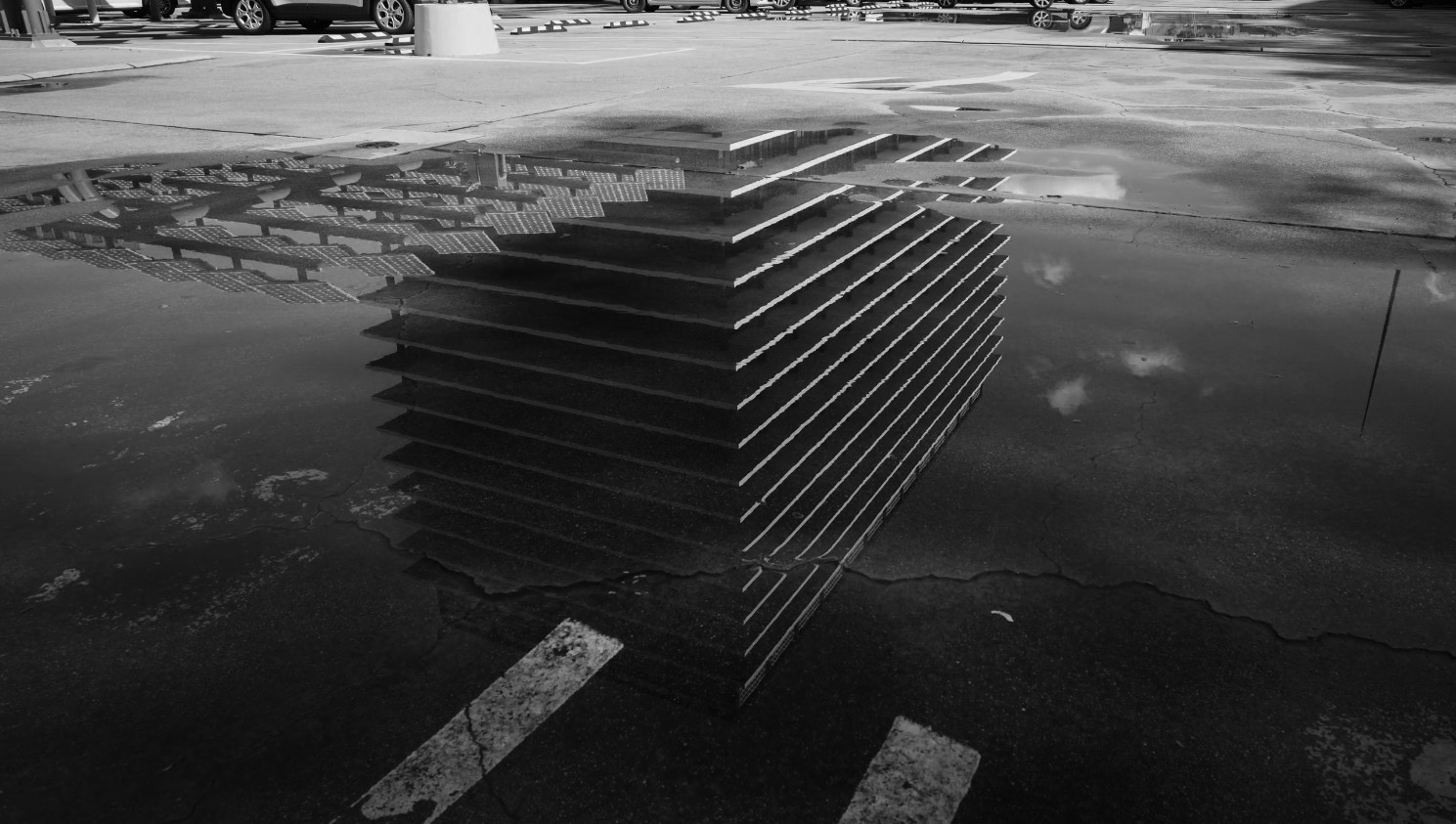 |
|
| (2019)* - Reflection of the JFB in water puddle located in the parking lot. Photo by Miguel Rodriguez |
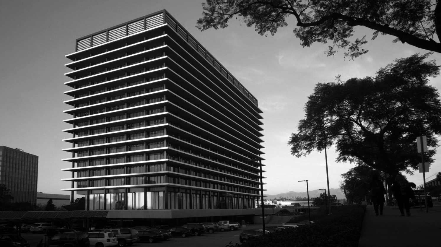 |
|
| (2019)* - Dusk view of the JFB Building as seen from near the NW corner of Hope and 2nd streets. Photo by Miguel Rodriguez |
 |
|
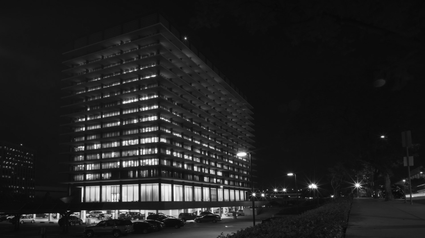
| (2019)* - Night view of the JFB Building as seen from near the NW corner of Hope and 2nd streets. Photo by Miguel Rodriguez |
 |
|
| (2010s)* – View looking southeast showing the JFB at sunset with the Dorothy Chandler Pavilion at left and the downtown skyline in the background. Photo courtesy of AC Martin. |
* * * * * |
Contemporary Views
 |
|
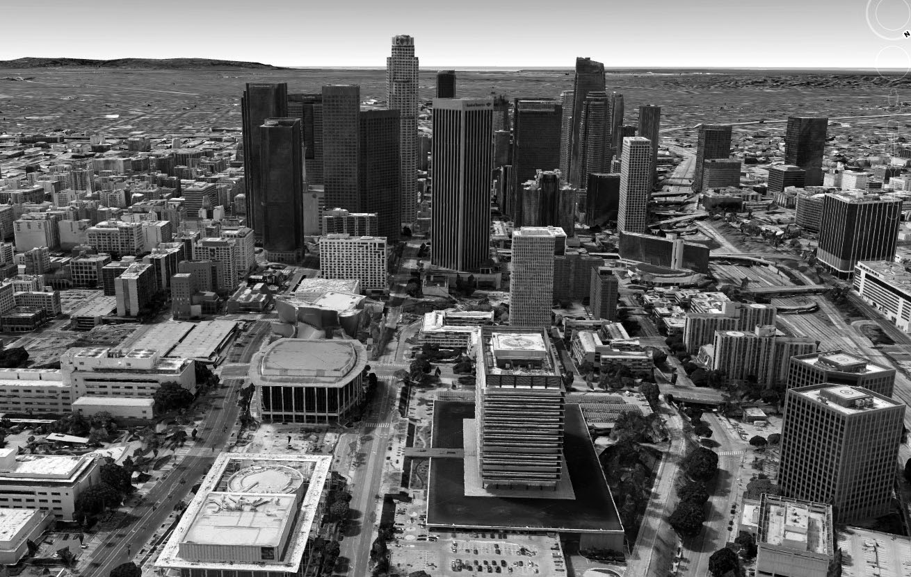
| (2015) – Google Earth view showing the JFOB with the Music Center to the left and city skyline in the background. |
 |
|
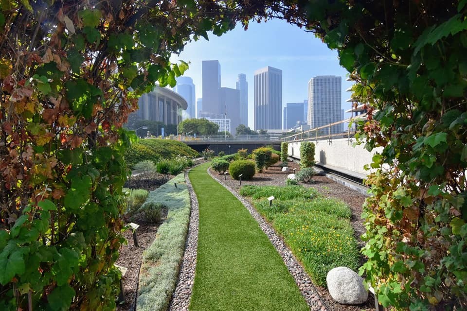
| (2022)* – View looking south toward the downtown skyline as seen from the landscaping in front of the JFOB. Photo courtesy of Paul Wright |
 |
|
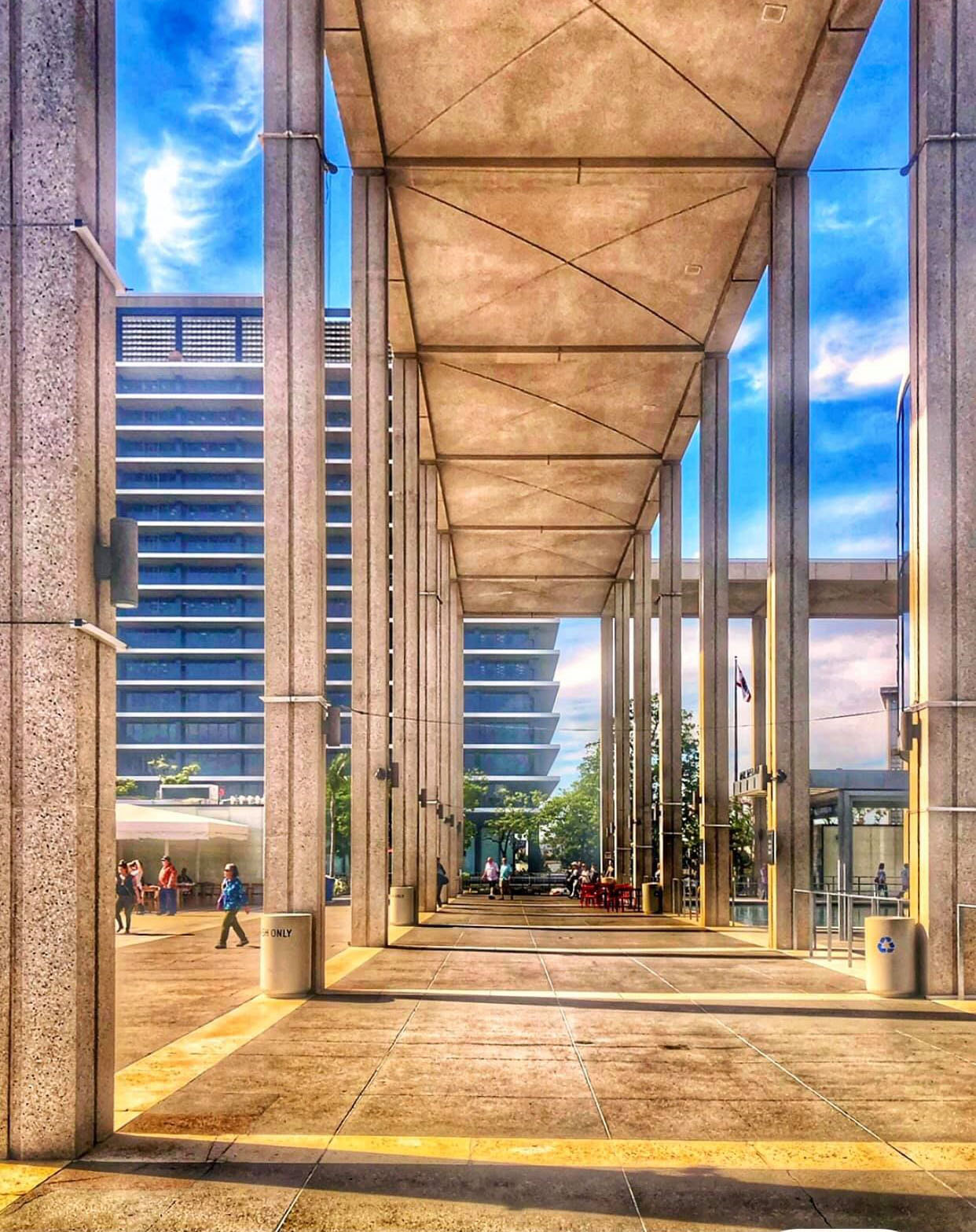
| (2021)* – The JFOB as seen from under the colonnade in front of the Mark Taper Forum. Photo by Shellie Winkler |
 |
|
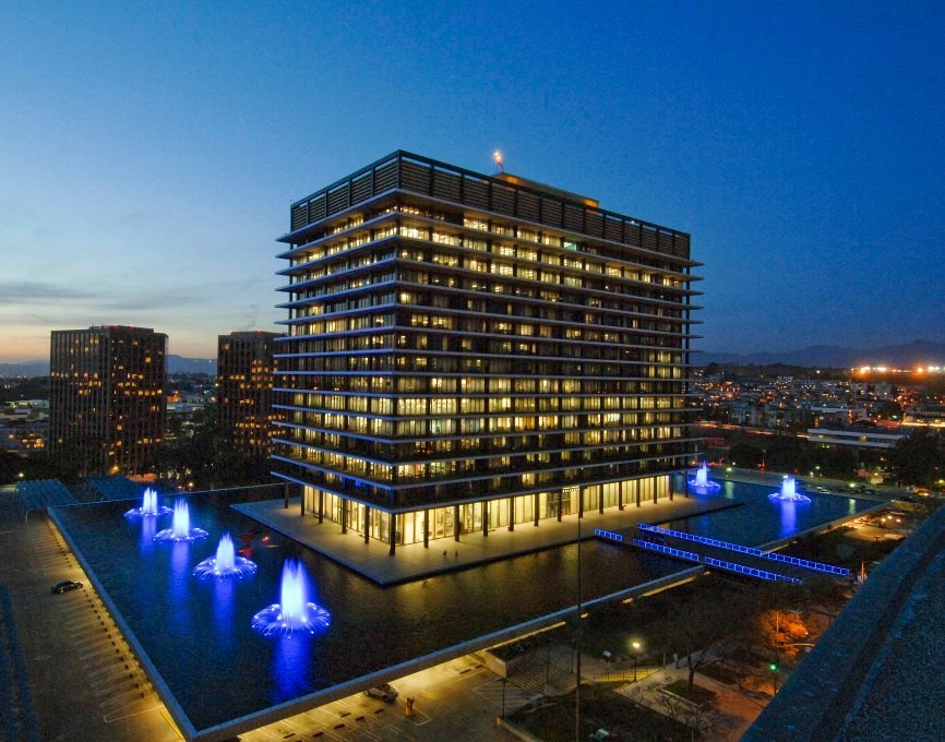
| (ca. 2017)* – Dusk view of the JFB looking northwest from the roof of the Dorothy Chandler Pavilion. The building is truly an LA icon. Photo courtesy of LADWP |
Historical Notes Bunker Hill’s Department of Water and Power building may be the only office building in Los Angeles even more beloved for its nighttime appearance than for its look in the light of day. |
 |
|
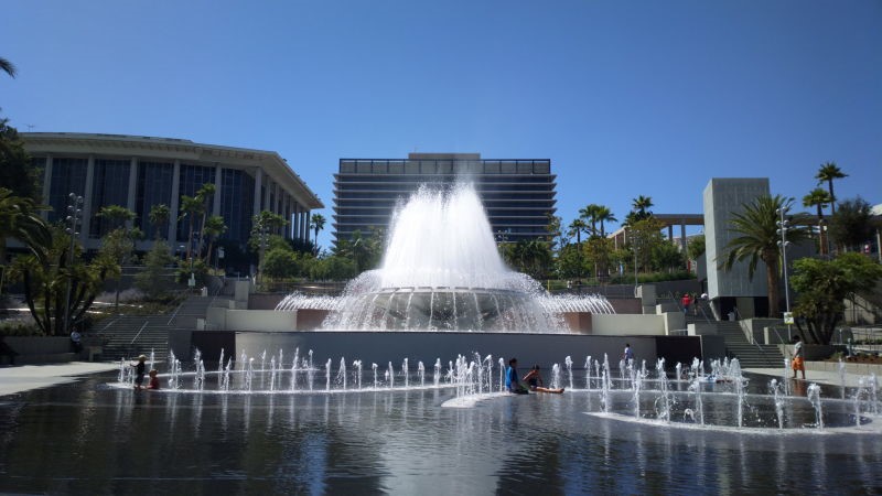
| (2016)* – View looking west toward the JFB from the Arthur J. Will Memorial Fountain in the Civic Center Mall, with the Dorothy Chandler Pavilion seen on the left. Photo by Al Pavanqkanan / Wikipedia |
 |
|
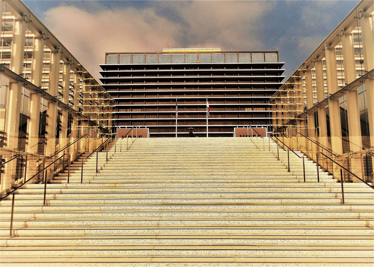
| (2020)* - Looking up the steps at Grand Avenue toward the JFOB. Photo by Howard Gray |
 |
|
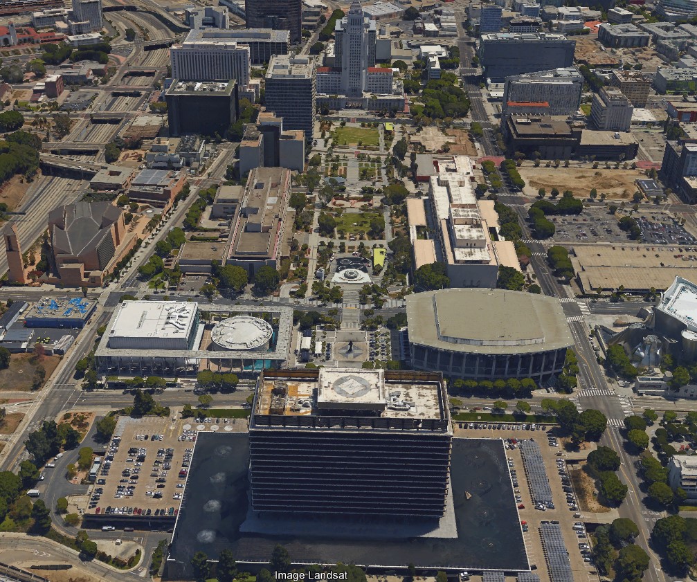
| (2016) – Google Earth View showing the Civic Center with City Hall in the distance as seen from above the John Ferraro Building. |
 |
|
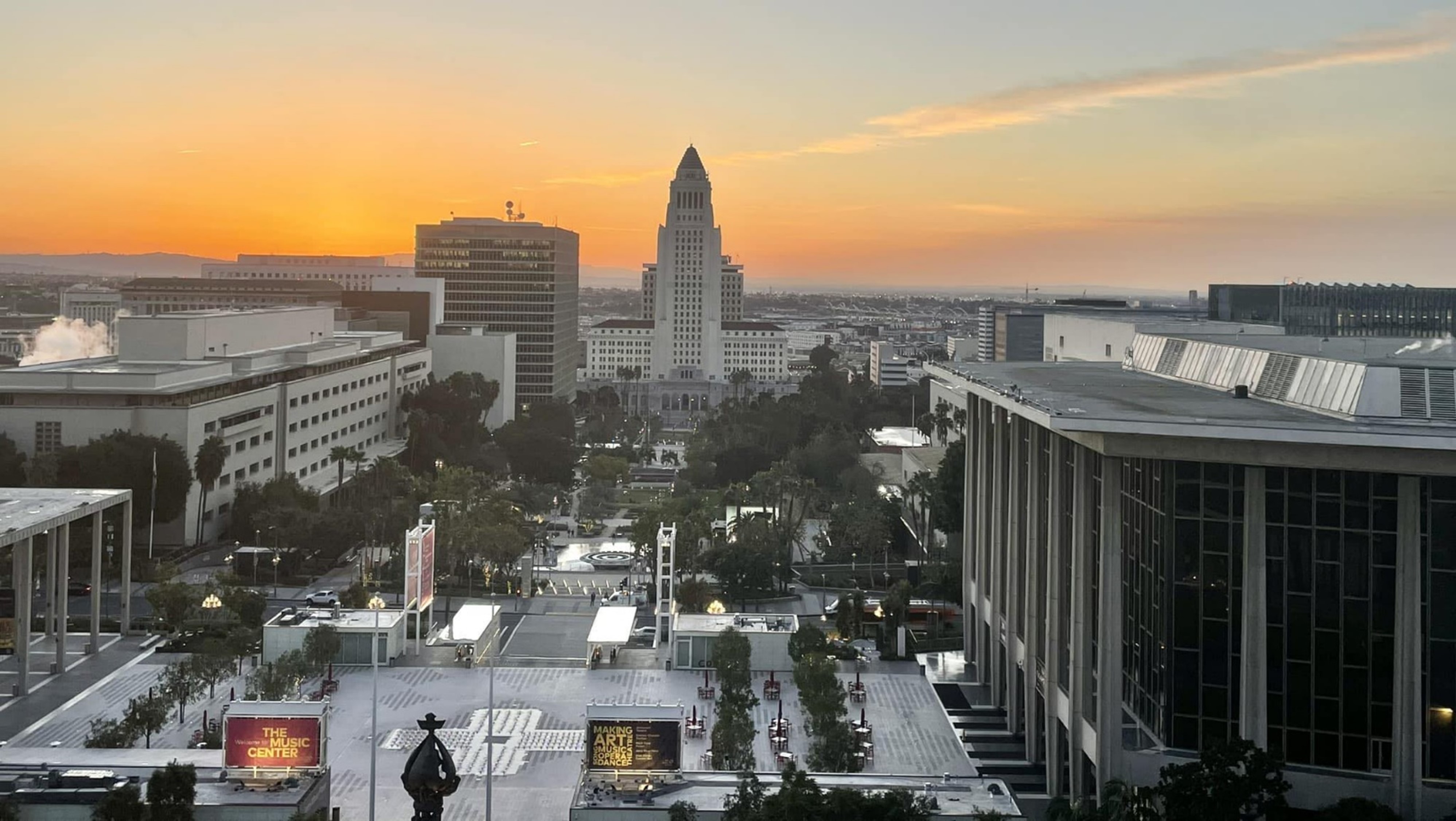
| (2023)* - View looking toward City Hall as seen from the John Ferraro Office Building. Photo by Walter Ramirez |
* * * * * |
Early DWP Office Buildings - A Short History
In 1902 the City of Los Angeles took over by purchase the old Los Angeles City Water Company and inherited the company's offices in what had been a furniture factory at Alameda and Marchessault streets (now Sunset Boulevard) across from the Plaza. Soon the municipal Water Department outgrew the little-brick building, and the search began for larger quarters. The Department relocated in 1904 at 440 South Hill Street. The Department moved in 1910 to 420-422 South Hill Street, a small one-story building on land now occupied by the Clark Hotel, however, these quarters were so crowded that less than a year later, in 1911, it was necessary to move again to a building at 636 South Hill Street, a remodeled furniture store. Here the Department functioned under its new name of Department of Public Service, comprising of the Bureau of Water Works and Supply and the Bureau of Power and Light. By 1914, growth was once again a problem and the Department leased a part of the newly completed Knickerbocker Building at 643-645 South Olive Street. In 1921 the Department purchased the seven-story Merchants Trust Building at 207 South Broadway, which was to remain its main headquarters building for forty-four years. Re-named the Department of Water and Power under the new City Charter of 1925, the Department completed construction in that year of the 13-story building at 316 West Second Street, and in 1926 completed the eight-story Hill Street building at 222 South Hill Street. These two buildings were joined with the 207 South Broadway facility to make one central headquarters complex. Continued growth of the City and the water and power services required more office space. The Washington Building at Third and Spring Streets was purchased in 1945, and the Wright and Callender Building at the southwest corner of Fourth and Hill Streets was acquired in 1946. Additional space was leased in the Subway Terminal Building from 1953 to 1958, and ten floors of the Black Building on the northwest corner of Fourth and Hill in 1958. Some central administrative offices also had to be housed in DWP buildings on the fringe of the downtown district, on Ducommun, North Main and Boylston Streets. The new General Office Building at 111 North Hope Street brought 3,500 employees of the Department under one roof when it opened in June, 1965. |
 |
|
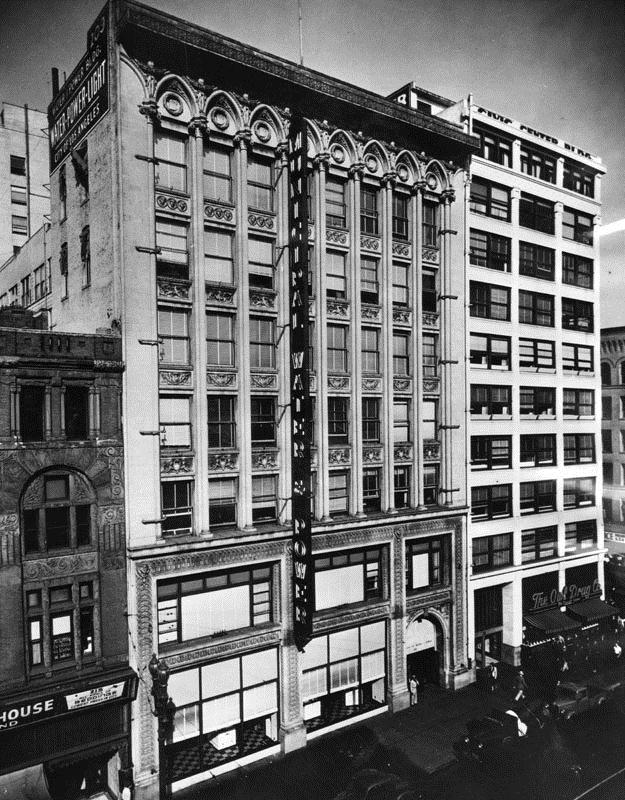
| (ca. 1921)* - View showing the seven-story Merchants Trust Company Building at 207 South Broadway, which was purchased by Water and Power in 1921. |
Historical Notes In 1921 the Department of Water and Power purchased the seven-story Merchants Trust Building at 207 South Broadway, which was to remain its main headquarters building for forty-four years. It is one of the 11 buildings the new General Office Building (now known as John Ferraro Building) replaced in 1965. |
 |
|
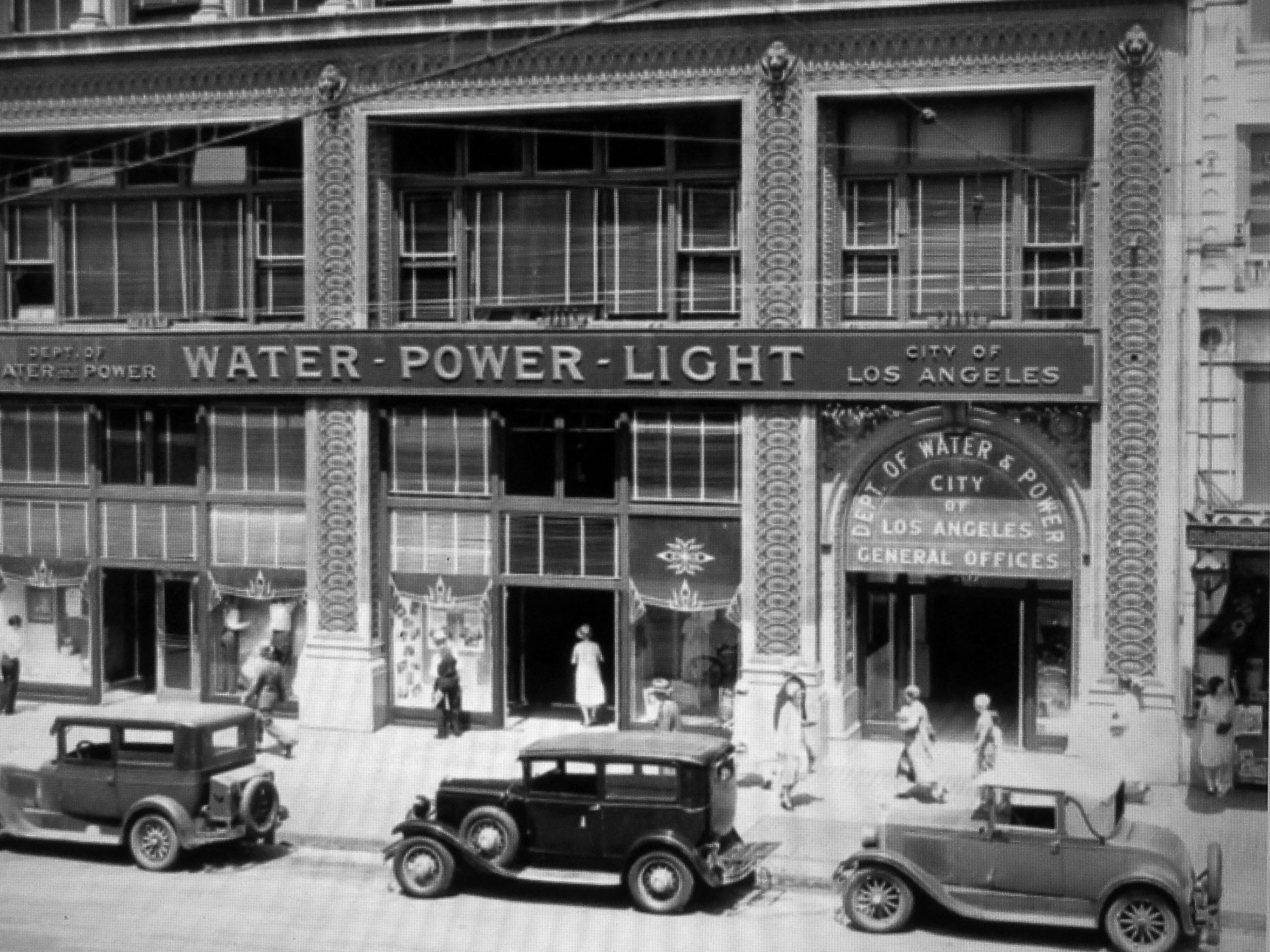
| (1920s)* – View showing the Department of Water & Power building located at 207 S. Broadway. |
 |
|
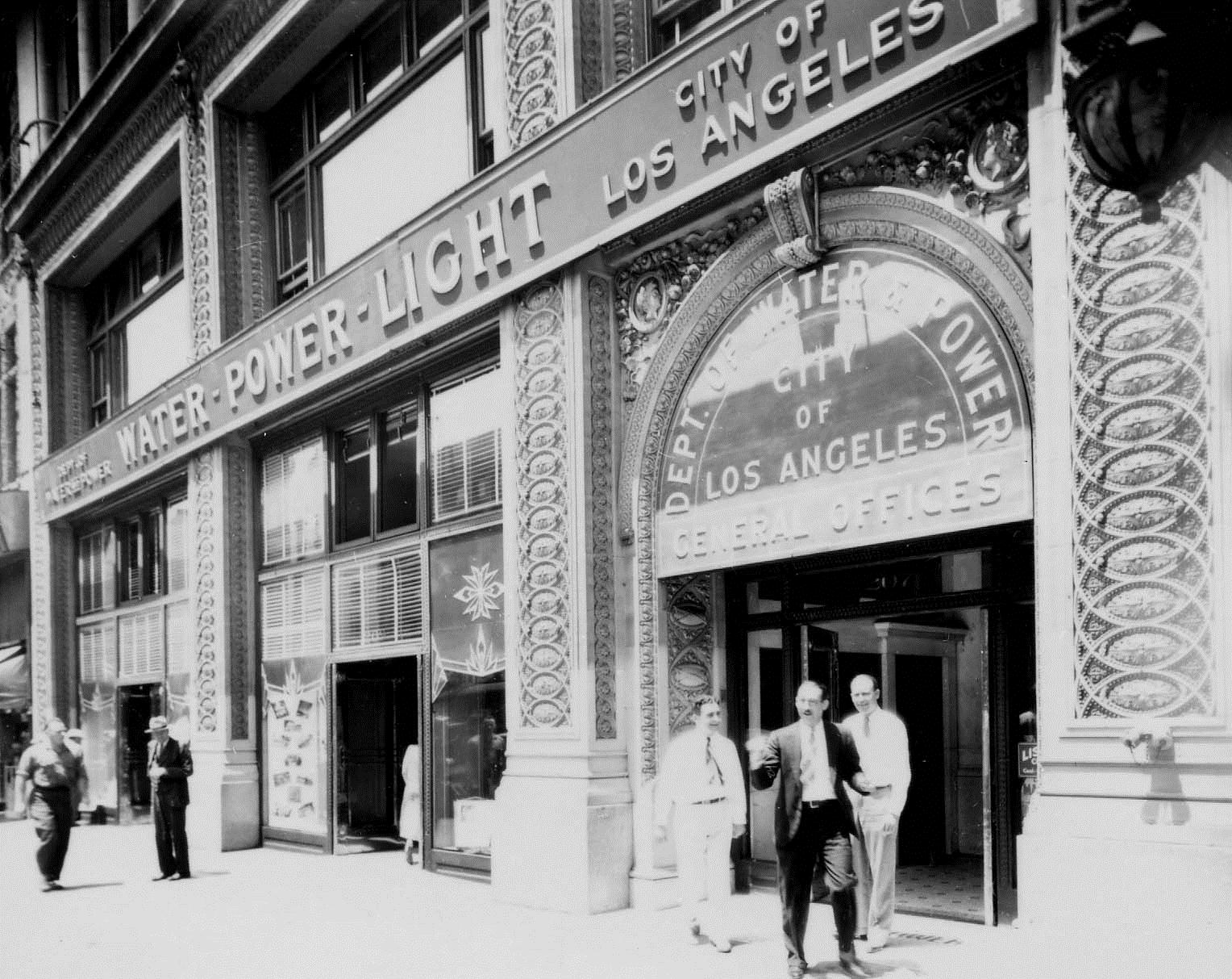
| (1920s) - View of the Department of Water and Power's General Office Buildi. The prominent sign on the face of the building reads: WATER - POWER - LIGHT. |
.jpg) |
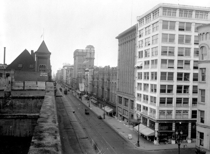
(Early 1920s)* - 207 South Broadway - Administrative headquarters had remained at the Broadway Building for many years since it was purchased, however, the Department quickly outgrew the office space it needed. Within only four years after purchasing the Broadway Building, the Department found itself adding facilities and erecting more office quarters. The first addition was the 13 story building at 316 W. Second Street, constructed by the Department in 1925. The next year, 1926, the eight story Hill Street building was built at 222 S. Hill Street. These two buildings were joined by stairs and hallways with the Broadway facility, making one large, central headquarters installation with entrances on Broadway, Second Street and Hill Street. From these three integrated structures, the Department’s operations had expanded to embrace six downtown office buildings. |
 |
|
| (Early 1920s)* - 207 South Broadway - When the Merchants Trust Company Building at 207 S. Broadway was purchased in 1921, it appeared the Department had, at last, a home that would adequately accommodate it for many, many years. However, growth continued at such a pace it necessitated new additions and expansions in Department facilities much earlier than anyone ever expected. |
.jpg) |
|
| (1920s)* - View looking south on Broadway from near 2nd Street. The Municipal Water & Power Headquarters can be seen on the right. Note the people lined up along the curbs and the American Flags on the right. This could be the prelude to a 4th of July Parade. |
.jpg) |
|
| (ca. 1949)* - View showing a DWP Streetlight Maintenance worker changing out a GE Form 81 teardrop lamp. In the background can be seen the Municipal Water and Power office building (aka Merchants Trust Building) located at 207 S. Broadway. |
 |
|
| (n.d.)* - Two of the six downtown office buildings employed by the Department of Water and Power were the Wright and Callender Building, located at the intersection of Fourth and Hill. |
* * * * * |
First Home of LA's Water Department
 |
|
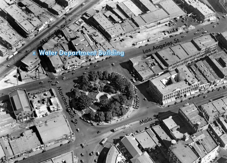
| (ca. 1924)* - Aerial view of the Los Angeles Plaza and surrounding buildings. The original Water Department Building can be seen in the upper left of the photo on the northwest corner of Alameda and Marchessault streets. |
Historical Notes The sole occupant of the entire city block (bounded by Los Angeles, Marchessault, and Alameda streets) was a sturdy, square, two-story brick structure. Built originally for a furniture factory, it was later remodeled to serve as a headquarters of the Los Angeles Water Department’s predecessor, the Los Angeles City Water Company. |
 |
|
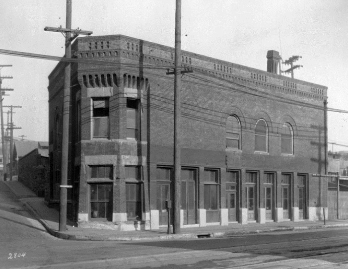
| (1920s)* - Original Water Department Building. The building on the northwest corner of Marchessault and North Alameda streets was the first headquarters of the municipal Water Department. |
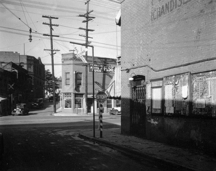
LADWP Historic Archive Original Water Department Building - For the twenty-eight stories and two basements of our City Hall, thirty floors in all, are outnumbered by the twenty-six stories and five basements, thirty-on floors in all, of the downtown offices of the Department of Water and Power. Yet, these office buildings of the Department, roomy and extensive though they be, come nowhere near to occupying an entire city block. In the square in which they stand, there are nineteen structures all together. Only three of these—less than a sixth—are ours. But there was a time in the history of the Department when its quarters did occupy a whole city block. And, strangely enough, this was in its formative days. The intersection of North Los Angeles and Marchessault streets is not so very far distant from our Broadway Building. A ten or fifteen minute stroll will bring one to a “flatiron” log, bounded by these two thoroughfares and North Alameda Street. The sole occupant of this entire city block was, and still is, a sturdy, square, two-story brick structure. Built originally for a furniture factory, it was later remodeled to serve as a headquarters of our predecessor, the Los Angeles City Water Company. Ownership and occupancy next passed to the newly fledged City Water Department, in whose possession and that of its successors in interest, it still continues, no longer as offices, but only as a warehouse for a firm of Chinese importers and the domicile of the chop suey and noodles emporium. |
 |
|
| (1920s)* - View looking west toward the northwest corner of Marchessault and Alameda streets where the original Los Angeles Water Department Building stands. |
First Home of the Los Angeles Water Department
Click HERE to see more in Water Department's Original Office Building. |
* * * * * |
Please Support Our CauseWater and Power Associates, Inc. is a non-profit, public service organization dedicated to preserving historical records and photos. Your generosity allows us to continue to disseminate knowledge of the rich and diverse multicultural history of the greater Los Angeles area; to serve as a resource of historical information; and to assist in the preservation of the city's historic records.
|
History of Water and Electricity in Los Angeles
More Historical Early Views
Newest Additions
Early LA Buildings and City Views
* * * * * |
References and Credits
* DWP - LA Public Library Image Archive
^ blogdowntown 6/24/10 Article - 45 Years Ago: New Water and Power Headquarters Dedicated
^^tumblr.com: John Ferraro Building; DWP Office Building
*#Noirish Los Angeles - forum.skyscraperpage.com: Downtown Aerial 1958; View from GOB; GOB from Parking Lot
+#San Francisco Museum of Modern Art
##Facebook: SoCal Historic Architecture
^*^Water and Power Building Pamphlet
^^^LA Public Library Image Archive
*^^Wikimapia: John Ferraro Building
**^LAist.com: Harbor Freeway, 1969
*^#Huntington Digital Library Archive
++#Facebook.com: Garden of Allah Novels
< Back
Menu
- Home
- Mission
- Museum
- Major Efforts
- Recent Newsletters
- Historical Op Ed Pieces
- Board Officers and Directors
- Mulholland/McCarthy Service Awards
- Positions on Owens Valley and the City of Los Angeles Issues
- Legislative Positions on
Water Issues
- Legislative Positions on
Energy Issues
- Membership
- Contact Us
- Search Index