Early Los Angeles City Views (1800s)
Neighborhoods, Streets, and the Life of the Growing City
Historical Photos of Early Los Angeles |
Introduction |
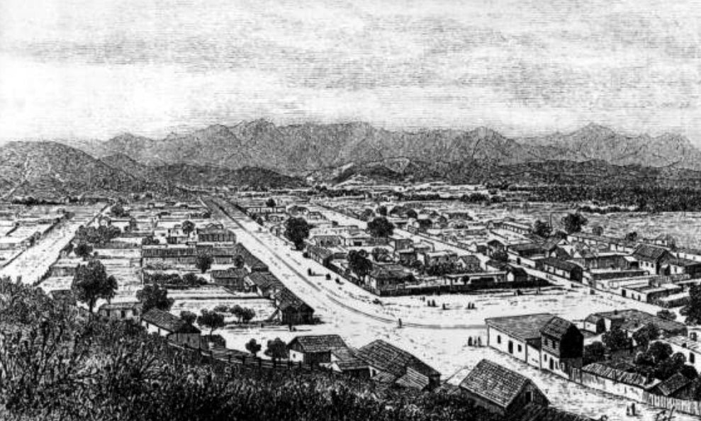
Page two of this series moves outward from the Plaza and into the neighborhoods, streets, and open spaces that gave early Los Angeles its distinctive shape. The images here trace several distinct communities that existed simultaneously within the young city, each with its own history and character. Calle de los Negros, the city's most notorious short street, led north from Los Angeles Street to the Plaza and became the setting for some of the most dramatic events in the city's early history, including the Chinese Massacre of 1871. Just beyond it, the Mexican barrio known as Sonora Town spread across the hill north of the Plaza, a community rooted in the mining era that endured well into the twentieth century.From there the views extend south and east, tracing the development of Broadway, then known as Fort Street, as it descended from the hills toward the original business district. Temple Street and Main Street emerge as the primary arteries of civic and commercial life, lined with hotels, stables, law offices, and storefronts that changed with every decade. The section also reaches across the Los Angeles River into Boyle Heights, then a residential hillside east of downtown, and ventures south along Main Street to farmlands and orange orchards that would eventually be absorbed by the expanding city. Together these scenes document a community in rapid transformation, one where open land and adobe walls still existed within a short walk of newly paved streets and electric wires.The period covered here runs roughly from the 1850s to the late 1880s, capturing Los Angeles at a moment when its population was accelerating toward the great land boom of 1887 and 1888. By the end of this era, the quiet streets shown in these photographs would be crowded with new arrivals, and the open countryside visible beyond the business district would be divided into subdivisions bearing the names of distant cities and romantic Spanish phrases. These images record what existed before that transformation and help explain why so little of it survived. |
In This Section |
* * * * * |
Calle de los Negros |
Just east of the Los Angeles Plaza stood a narrow dirt street that occupied an outsized place in the city's early history. Barely five hundred feet long, Calle de los Negros formed the eastern edge of the Plaza district and became one of the most active and controversial places in nineteenth century Los Angeles. Along its short length stood adobe buildings, hotels, stores, saloons, and gathering places that reflected the changing population and shifting character of the young city.Over time the street became associated with commerce, immigration, entertainment, and some of Los Angeles's most difficult chapters. Communities overlapped here, and tensions that existed elsewhere in the growing city often became visible along this small corridor. The images that follow trace Calle de los Negros from its earliest documented years through its final appearance before being incorporated into the expanding street grid of modern Los Angeles. |
 |
|
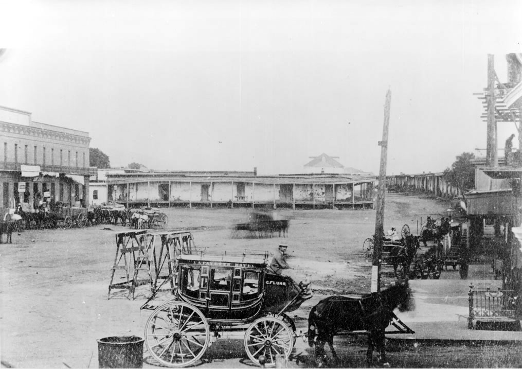
| (1870s)* -Stagecoach of the Lafayette Hotel near the adobe buildings of Calle de los Negros at present day Los Angeles and Arcadia streets. Visible in the background is the Antonio Coronel adobe, one of the most historically significant structures in the district. |
Historical Notes The stagecoach visible here belonged to the Lafayette Hotel, the second hotel established in Los Angeles after the Bella Union. At the far right of the image is the entrance to Calle de los Negros, which extended southward from the Plaza toward Arcadia Street. Nearby stood businesses that served travelers and local residents, including grocery operations and saloons that helped make this area one of the city's busiest gathering places. The open ground in the foreground marks the northern end of Los Angeles Street at a time when much of the district still retained the informal appearance of the earlier pueblo. The Lafayette Hotel occupied an important position in the transportation network of early Los Angeles, serving passengers arriving by stage from San Bernardino and communities farther inland. The adobe buildings visible in the background represent an older layer of the city that remained dominant in this neighborhood even as brick construction and commercial development began reshaping nearby blocks. Images such as this preserve a brief moment when Los Angeles still operated at the scale of a frontier town while beginning its transition into a larger urban center. |
 |
|
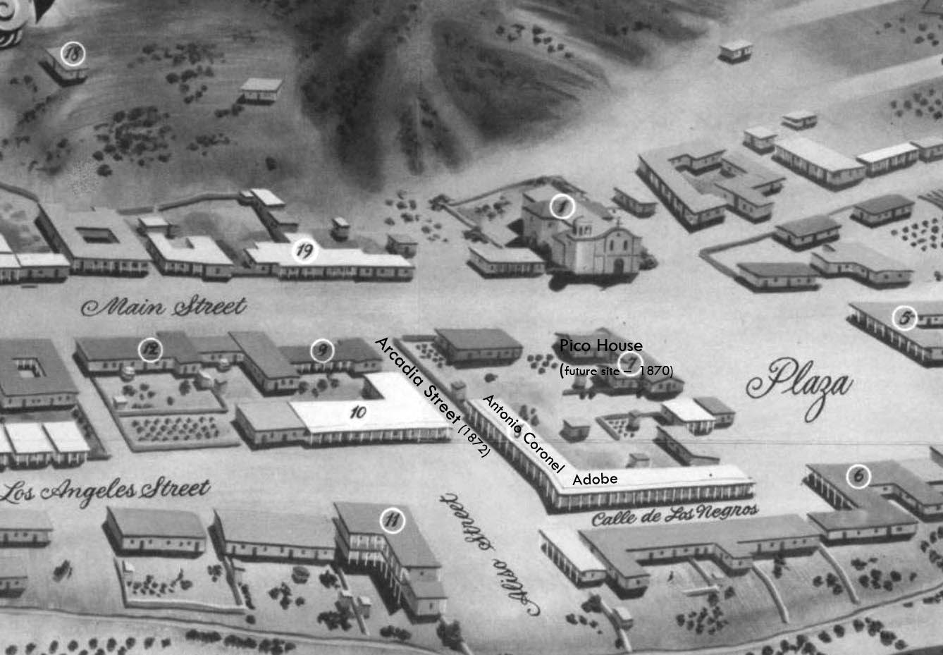
| (1850)* - Early map of the Plaza district showing the location of Calle de los Negros and surrounding streets before many of Los Angeles's later landmarks had been constructed. |
Historical Notes This map documents the area surrounding the Los Angeles Plaza as it existed in 1850, before many of the city's best known landmarks had yet been built. The Pico House, later one of the most recognizable buildings in the district, would not be constructed until 1870. The Antonio Coronel Adobe occupied an important corner lot near the Plaza, and Calle de los Negros already appeared as a narrow but strategically placed street connecting nearby commercial activity. The portion of Aliso Street visible here was renamed Arcadia Street in 1872 as Los Angeles expanded and reorganized its street system during the American period. The map demonstrates how central Calle de los Negros was to the surrounding neighborhood despite its small size, linking the Plaza with businesses and residences clustered nearby. |
 |
|
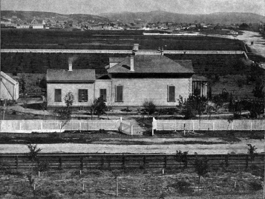
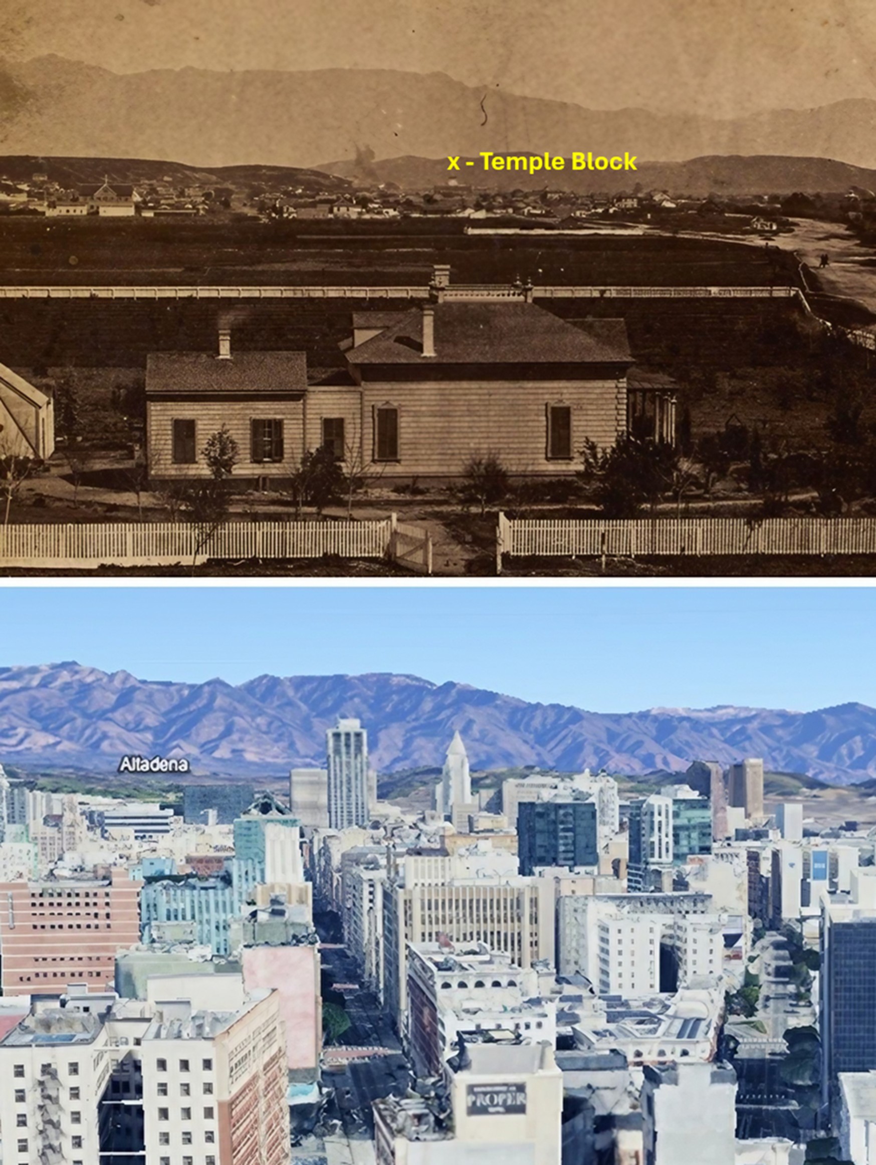
| (1875)* - Closer view of the Coronel Adobe with its covered sidewalk, located on the northwest corner of Arcadia Street and Calle de Los Negros (later Los Angeles Street). The back part of the Pico House (built in 1870) across Sanchez Street is on the left and the LA Plaza (out of view) is at center-right. |
Historical Notes This adobe building belonged to Antonio Franco Coronel, one of nineteenth century Los Angeles's most influential civic leaders. Coronel served as mayor of Los Angeles and later as California state treasurer. He owned extensive property in this district, and the covered walkways visible here reflected the practical design of California adobe architecture, providing shade and creating sheltered spaces for commerce. By the 1870s this neighborhood had changed considerably from its earlier identity as a residential district of prominent Californio families. Portions of the area became associated with Los Angeles's earliest Chinatown, and the Coronel block later became connected with events surrounding the Chinese Massacre of 1871. This image preserves one of the last views of the district before modernization transformed the area. |
.jpg) |
|
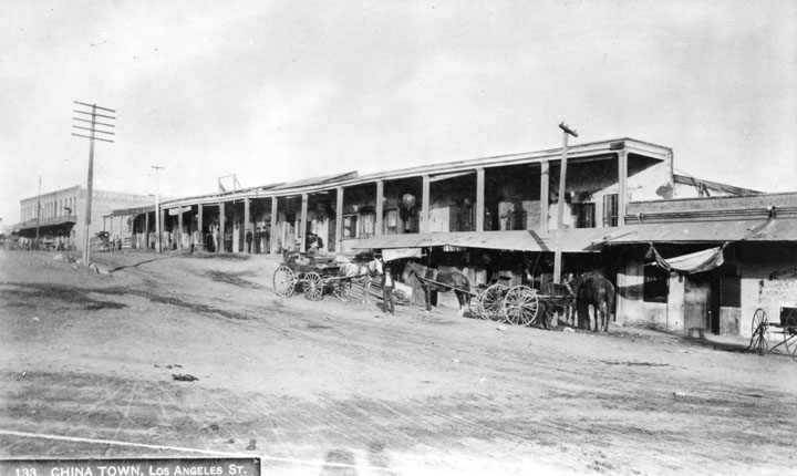
| (ca. 1882)* - Stereoscopic photograph of Calle de los Negros, lined with adobe structures. By the late 1860s the area was mainly inhabited by Chinese residents. In the right foreground is a horseshoe-shaped sign reading "J. Kennedy." At the far left is a portion of the Coronel building, in which the Chinese Massacre of 1871 occurred. Photo courtesy of the Workman and Temple Family Homestead Museum. |
Historical Notes The street documented in this stereoscopic photograph had carried several names before it was officially designated Los Angeles Street in 1854. Prior to the American-era survey of 1849, the long corridor running south from the Plaza toward the harbor was known by different names at different points along its length. The northern section near the Plaza was called Calle de la Zanja, or Ditch Street, in reference to the water channel that ran nearby. Farther south, the road passed through vineyards and became Calle de los Vinas before continuing as Calle de los Huertos, or Orchard Street, in the area that would eventually become San Pedro Street. Together these connected segments formed the principal route linking downtown Los Angeles to the harbor at San Pedro. The short northern stretch captured in this photograph, known as Calle de los Negros, occupied only about five hundred feet at the northern end of this longer thoroughfare. The horseshoe sign for J. Kennedy visible in the foreground suggests that the street continued to function as a commercial corridor even as the neighborhood changed around it. The photograph was taken by stereoscopic camera, producing a three-dimensional effect when viewed through a stereoscope, and is part of the collection of the Workman and Temple Family Homestead Museum. |
 |
|
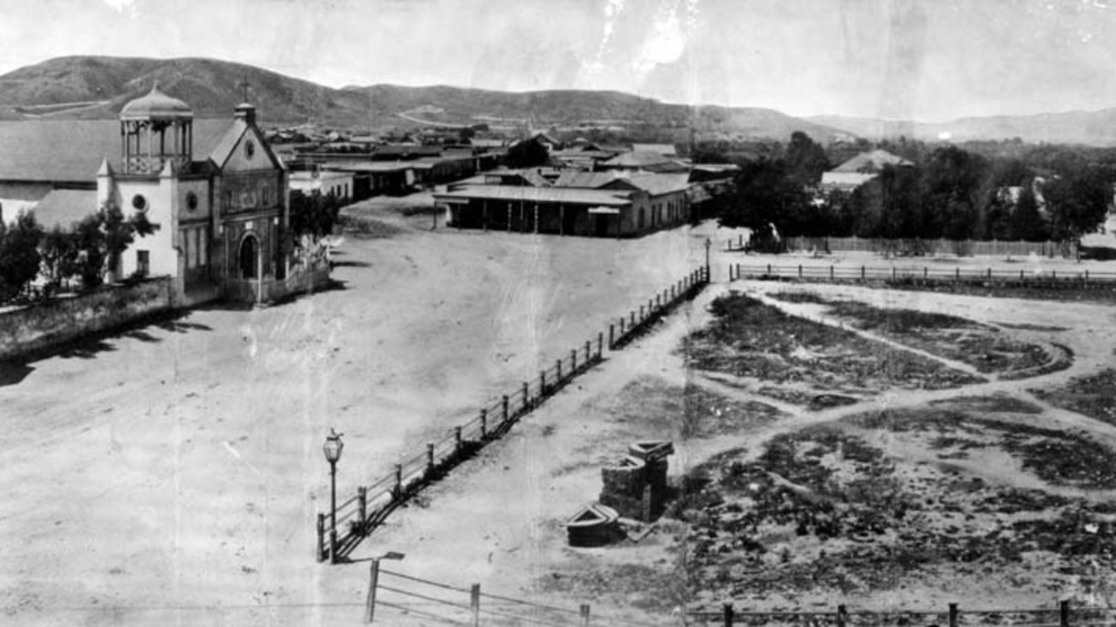
| (ca. 1884)* - View of Calle de los Negros. On the left is the adobe of Antonio Coronel; behind the adobe and with belltower is the Plaza Firehouse; center with a gable roof is the Vincent Lugo Adobe (facing the plaza on Los Angeles Street); and right with columns is the Antonio Maria Lugo adobe, which he willed to his son, Dolores del Carmen Lugo. View is looking north toward the Plaza from near the northeast corner of Calle de Los Negros and Aliso Street. |
Historical Notes This view looking north along Calle de los Negros captures the street at a moment when several of its most distinctive structures were still standing. On the left is the Antonio Coronel adobe block. The building behind it with the belltower is the Plaza Firehouse, completed in 1884 and still standing today as a city historic landmark. The gabled structure at center is the Vincent Lugo Adobe, facing the Plaza on Los Angeles Street, and to the right stands the Antonio Maria Lugo adobe, which Don Antonio Lugo willed to his son Dolores del Carmen Lugo. The view is taken from near the northeast corner of Calle de los Negros and Aliso Street, looking northward toward the Plaza. The street had a reputation throughout this period as the center of what contemporary observers called the city's red light district, with saloons, gambling establishments, and entertainment venues concentrated along its short length. That reputation was inseparable from its history as a racially diverse corridor at the edge of the Plaza, a location that placed it outside the more closely regulated commercial streets of the central business district while keeping it within easy reach of the city's main gathering places. The construction of the Plaza Firehouse along this same block in 1884 represented an effort to bring civic order to an area long associated with disorder. The Plaza Firehouse was built in 1884. Click HERE to see more. |
 |
|
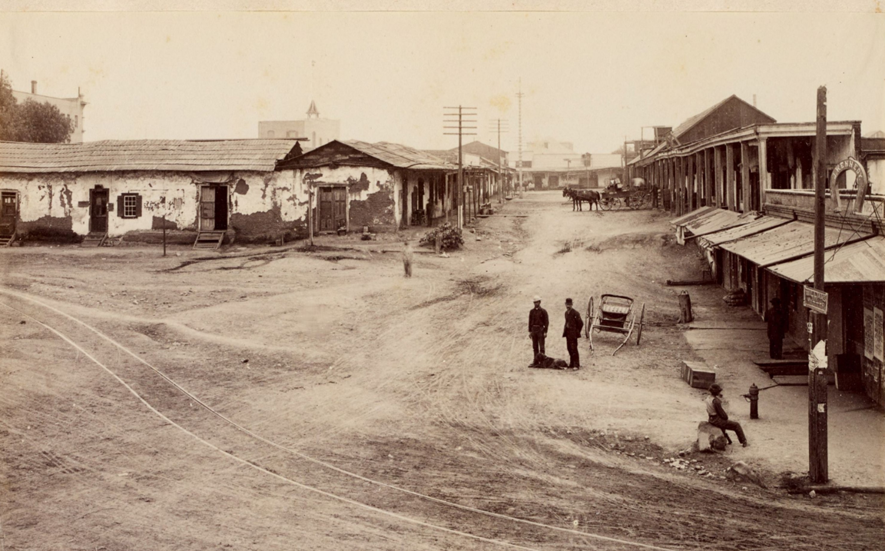
| (1880s)* - Elevated view of the dirt road, horse-drawn wagons, and storefronts along the Calle de los Negros (also known as "Nigger Alley") in Old Chinatown in Los Angeles, California, with a sign for "J. Kennedy" in the shape of a horseshoe at right and a fire hydrant on the sidewalk. Photo from the Ernest Marques Collection. |
Historical Notes This district became the site of one of the most tragic events in early Los Angeles history. On October 24, 1871, a mob attacked Chinese residents living in the area in what became known as the Chinese Massacre of 1871, one of the deadliest incidents of anti-Chinese violence in American history. More than a decade later, many of the same adobe structures remained standing. The image captures a neighborhood caught between older patterns of settlement and the growing infrastructure of a rapidly expanding American city. |
 |
|
| (ca. 1886)* - View of Calle de los Negros, running south of the Plaza along what is now the east side of Los Angeles Street. |
Historical Notes This late view of Calle de los Negros, taken around 1886, captures the street in its final years before it was absorbed into the expanding grid of Los Angeles Street. The alley ran for approximately five hundred feet between the intersection of Arcadia Street at the south and the Plaza at the north, placing it at the immediate northeastern edge of the city's original business district. By the time this photograph was made, the street had already survived decades of controversy and was approaching its end. The name Calle de los Negros is believed to have originated with the dark-complexioned Californios, the Spanish-speaking mixed-race population of pre-American California, who were among the early residents of this part of the pueblo. Over time the street became home to a succession of different communities, each attracted by the low rents and central location that made this part of town accessible to those outside the economic mainstream. The extension of Los Angeles Street, completed in 1888, eliminated the alley entirely and erased the last physical trace of a corridor that had defined the city's most turbulent neighborhood for three decades. |
 |
|
| (1886)* - View looking east from Aliso Street at the entrance to "the alley". |
Historical Notes This view looking east from Aliso Street toward the southern entrance of Calle de los Negros was made in 1886, at the moment the Plaza district was beginning to be physically reorganized to accommodate a growing city. The narrow alley visible here had long remained separate from the broader street pattern developing elsewhere in Los Angeles, preserving the irregular layout of the earlier pueblo. From this angle, its modest scale becomes clear — little more than a wagon-width passage connecting one of the city's most active but least formal urban spaces. Rather than preserving the old alignment, city planners extended and widened Los Angeles Street through this block, creating a more continuous north–south corridor and reshaping circulation around the Plaza. The change reflected a broader transition underway across downtown as informal lanes, adobe districts, and localized neighborhoods gave way to standardized streets and commercial expansion. Today the area once occupied by Calle de los Negros lies adjacent to the Hollywood Freeway corridor, constructed through this part of downtown during the 1950s. Although little remains above ground to indicate where the alley stood, this photograph preserves one of the last surviving views of a place whose influence on early Los Angeles extended far beyond its size. |
Section Reflections By the late 1880s, Calle de los Negros had disappeared from the city map, reconfigured into the expanding street system and eventually erased by later redevelopment. Yet for several decades this narrow corridor stood at the center of many of the forces that shaped early Los Angeles — immigration, commerce, migration, transportation, social change, conflict, and urban growth. Today little remains to indicate where the street once stood, but the photographs preserved in this section allow us to reconstruct a place that played a larger role in the city's history than its modest size would suggest. Together they reveal not only how Los Angeles looked, but how it evolved during one of the most formative periods in its development. |
* * * * * |
Sonora Town: Beyond the Plaza |
From Eternity Street to Broadway |
North of the Los Angeles Plaza and below the slopes of Fort Hill grew one of the city's earliest and most distinctive neighborhoods — Sonora Town. Originally settled by families from Sonora, Mexico during and after the Gold Rush era, the district developed into one of Los Angeles's earliest and most important Mexican barrios and became home to a growing residential community clustered around adobe houses, courtyards, workshops, and unpaved streets.Unlike the commercial blocks surrounding the Plaza, Sonora Town remained primarily residential through much of the nineteenth century. Streets climbed and curved with the natural terrain, and homes spread across hillsides that today have been cut down, tunneled through, or integrated into the modern street grid.The images in this section follow Sonora Town during the years when Los Angeles expanded beyond its original pueblo center. They document changing street names, evolving transportation routes, and a landscape that would eventually become part of North Broadway, Chinatown, and downtown Los Angeles.Together these views capture a neighborhood in transition — from a hillside community shaped by Mexican settlement patterns into an increasingly connected urban district whose historic routes continue to define the city today. |
 |
|
| (ca. 1869)* – View of north Broadway (then Eternity Street) in Sonora Town looking north from Fort Hill. |
Historical Notes This view from Fort Hill looks northward along what was then called Eternity Street, one of several roads that would eventually become part of North Broadway. The neighborhood visible here was known as Sonora Town, one of Los Angeles's earliest and most influential Mexican barrios and among the city's most distinctive residential districts. The settlement took its name from the large number of miners and families who arrived from the Mexican state of Sonora during and after the California Gold Rush of 1849. Many Sonorans had experience in placer mining and settled throughout Southern California after opportunities in the gold fields proved limited or unstable. In Los Angeles, many established homes north of the Plaza in the district shown here, creating a neighborhood that retained a strong Mexican identity well into the American period. The adobe and wood-frame dwellings visible across the hillside reflect the modest but established character of the community by the late 1860s. Unlike the commercial streets closer to the Plaza, Sonora Town developed as a residential district where families built homes on individual lots, often separated by gardens, courtyards, and open space. Fort Hill, from which this photograph was taken, would later be partially cut away and tunneled to accommodate the expansion of North Broadway, permanently altering the landscape seen in this image. |
 |
|
| (ca. 1870)* - Reproduction of a drawing from "A Flower from the Golden Land" by Ludwig Louis Salvator depicting north Broadway from Hill Street south of Sunset Boulevard in Sonora Town. |
Historical Notes This image reproduces a drawing created by Ludwig Louis Salvator, an Austrian archduke of Tuscan birth, traveler, and author whose observations provide one of the most valuable visual records of Los Angeles during the 1870s. His illustrated account, Eine Blume aus dem goldenen Lande (A Flower from the Golden Land), later appeared in English in 1929 under the title Los Angeles in the Sunny Seventies: A Flower from the Golden Land and remains an important source for understanding the city's early development. The drawing shows North Broadway — then represented by overlapping street segments including Eternity Street and Buena Vista Street — curving northward through Sonora Town toward the surrounding hills. Salvator carefully captured the neighborhood's urban form, showing residences organized around courtyards and open spaces in patterns that reflected Mexican and Spanish colonial traditions. The streetcar rails visible in the roadway represent an early phase of Los Angeles transportation infrastructure. Horse-drawn street service along this corridor connected the Plaza with developing neighborhoods to the north and foreshadowed the transit expansion that would accelerate during the following decades. The curving alignment of the street and surrounding hills preserve a sense of the natural topography that once shaped daily life in Sonora Town. |
 |
|
| (ca. 1871)* - Early view of Eternity Street in Sonora Town, northeast of Fort Moore Hill. An arrow points to the adobe home of Don Jose Aguilar. |
Historical Notes The road visible here was known as Calle Eternidad — Eternity Street — one of the most memorable place names in early Los Angeles. The name reflected its destination: for decades the dead of the pueblo were carried along this route to Campo Santo, the city's earliest cemetery located near its northern end. The adobe home of Don Jose Aguilar, identified by the arrow, represents the established Californio households that anchored Sonora Town during this period. Buildings such as this reflected the architectural traditions that defined the neighborhood before later waves of redevelopment transformed the district. The street's name would not survive the city's growth. Eternity Street was later renamed Buena Vista Street and extended northward toward the river. Fort Street to the south was eventually tunneled through Fort Moore Hill and connected into the same corridor, forming the continuous route that became North Broadway by 1890. |
 |
|
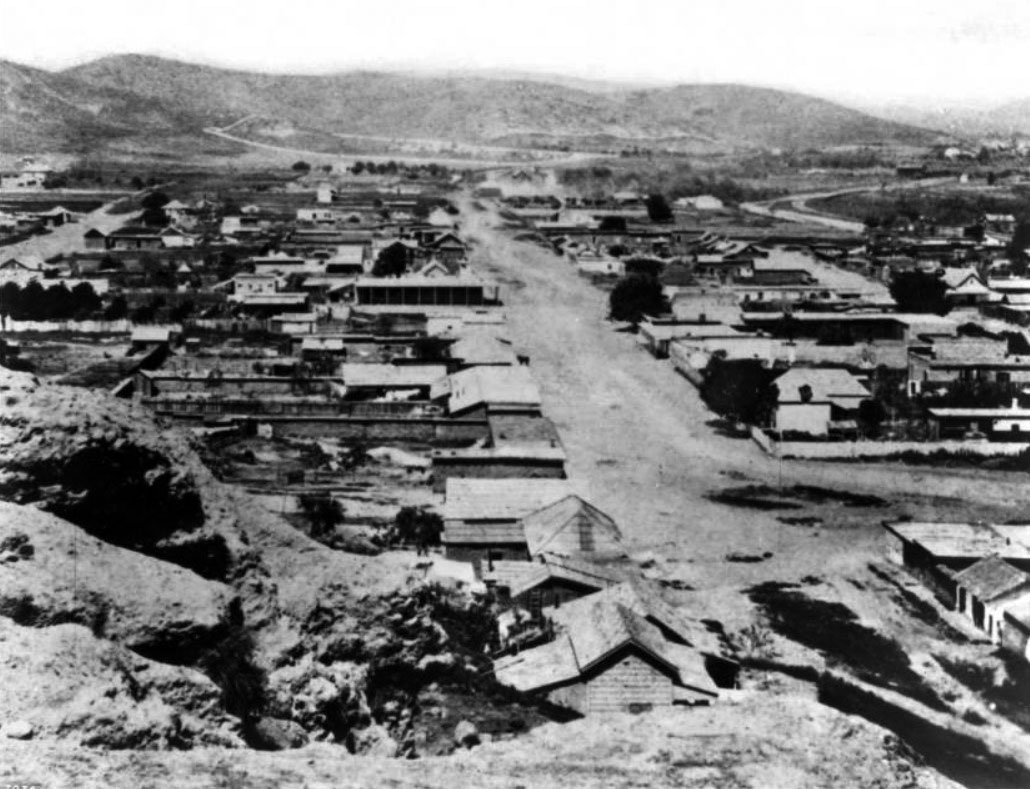
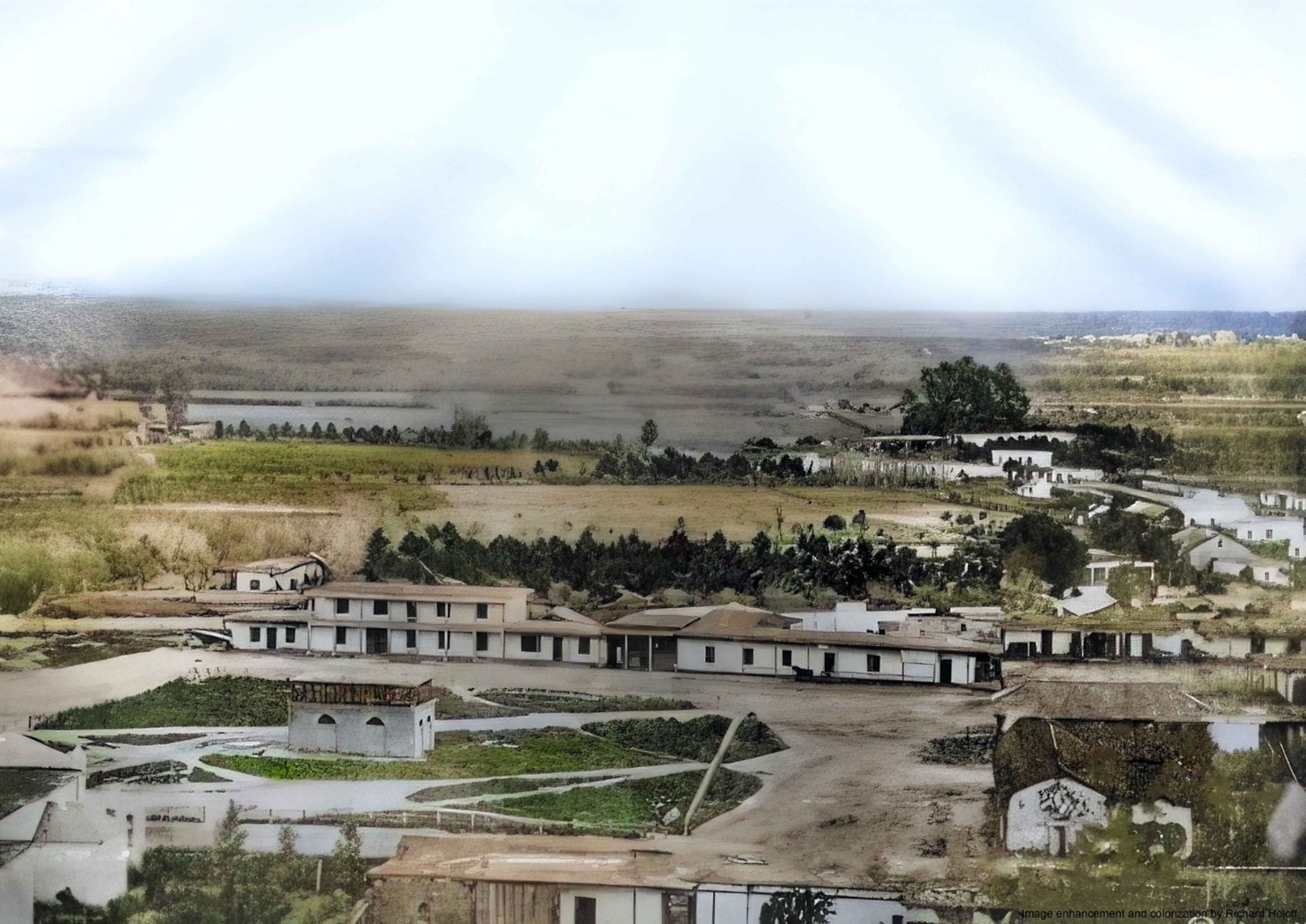
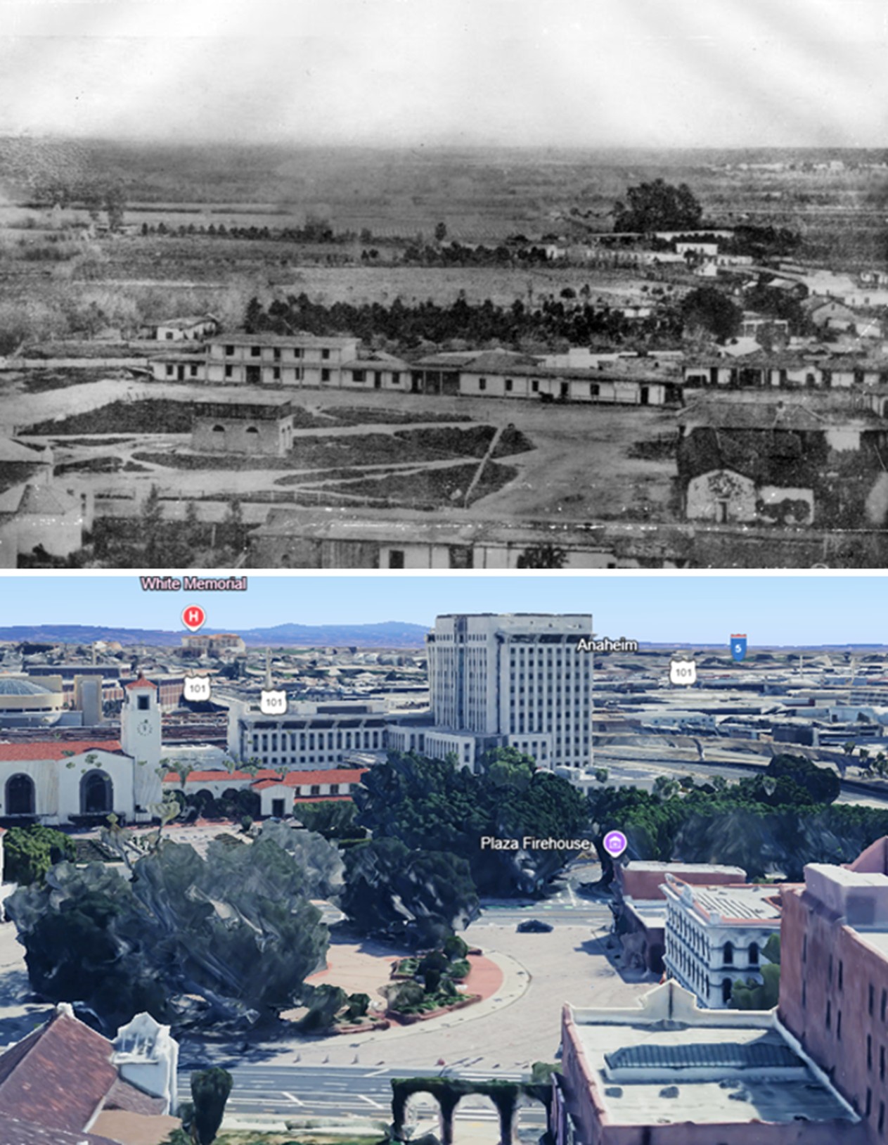
| (1871)* - View of Los Angeles, Sonora Town in 1871. Photograph taken from a hilltop vantage point on Fort Moore Hill, identified in period sources as the Banning residence. View is east of North Broadway (then Buena Vista), from the hill above the location of the later North Broadway tunnel. Southern Pacific Railroad shops can be seen in the distance. |
Historical Notes This image offers one of the most complete surviving views of Sonora Town during the early American era. The elevated vantage point overlooking the northern residential district reveals how the neighborhood spread across the hills north of the Plaza before later grading and street improvements reshaped the landscape. The street below would carry several names before becoming Broadway. Portions were known as Calle Fortin (Fort Street), while others retained the names Eternity Street, Downey Avenue, and Buena Vista Street — traditionally associated with the scenic outlook from the hillside. The gradual consolidation of these segments reflected Los Angeles's transition from a loosely connected pueblo into an organized city. Broadway was officially dedicated in 1890, and by 1910 the full corridor had been unified under a single name. The Southern Pacific Railroad facilities visible in the distance signal the industrial growth that was already beginning to reshape the eastern edge of Los Angeles. |
 |
|
| (1870s)* - Early view of Eternity Street (later North Broadway) in Sonora Town, northeast of Fort Moore Hill. |
Historical Notes This view captures the corridor during the decade when Los Angeles entered its first significant period of American-era growth. The unpaved road, scattered development, and open terrain visible here would be dramatically altered within a generation by population growth, real estate development, and infrastructure investment. By the 1870s Sonora Town had already begun evolving from its earlier Californio identity. New arrivals from across Mexico, China, and the United States settled in the neighborhood, drawn by affordable housing and proximity to the Plaza. Over time portions of Sonora Town became connected with the expanding Chinese community and contributed to the development of Old Chinatown. The hillside visible here was later reshaped during construction projects that transformed the northern approach to downtown and permanently changed the topography of Fort Moore Hill. |
Then and Now
 |
|
| (1870s vs 2020s) - Looking northeast on Broadway from just south of Cesar Chavez Ave (Sunset Blvd). Photo comparison by Jack Feldman. |
Historical Notes Although nearly every structure visible in the historic image has disappeared, the alignment of the corridor and surrounding landscape still reveal the geography that shaped Sonora Town. The hills that once framed Eternity Street remain visible beyond the modern city, while the dragon sculpture in the Broadway median marks the heart of the Chinatown district that succeeded the earlier Mexican barrio documented in these photographs. The street itself — widened, graded, and paved — still follows essentially the same northward path established more than a century and a half ago, preserving in its alignment one of the oldest continuous routes in Los Angeles. Click HERE to see more Early Views of Sonora Town. |
* * * * * |
Calvary Cemetery |
The Road to Eternity |
At the northern end of Eternity Street, where the road climbed out of Sonora Town toward the Stone Quarry Hills, lay Los Angeles's first dedicated Catholic cemetery. For half a century, this burial ground received the dead of the growing city — pioneers and civic leaders, Indigenous Angelenos, and ordinary residents whose names never entered the history books.The street that led there earned its name from that journey. Though the cemetery disappeared and the landscape changed, traces of its memory remain today in a high school football field called The Graveyard and a team known as the Phantoms. |
 |
|
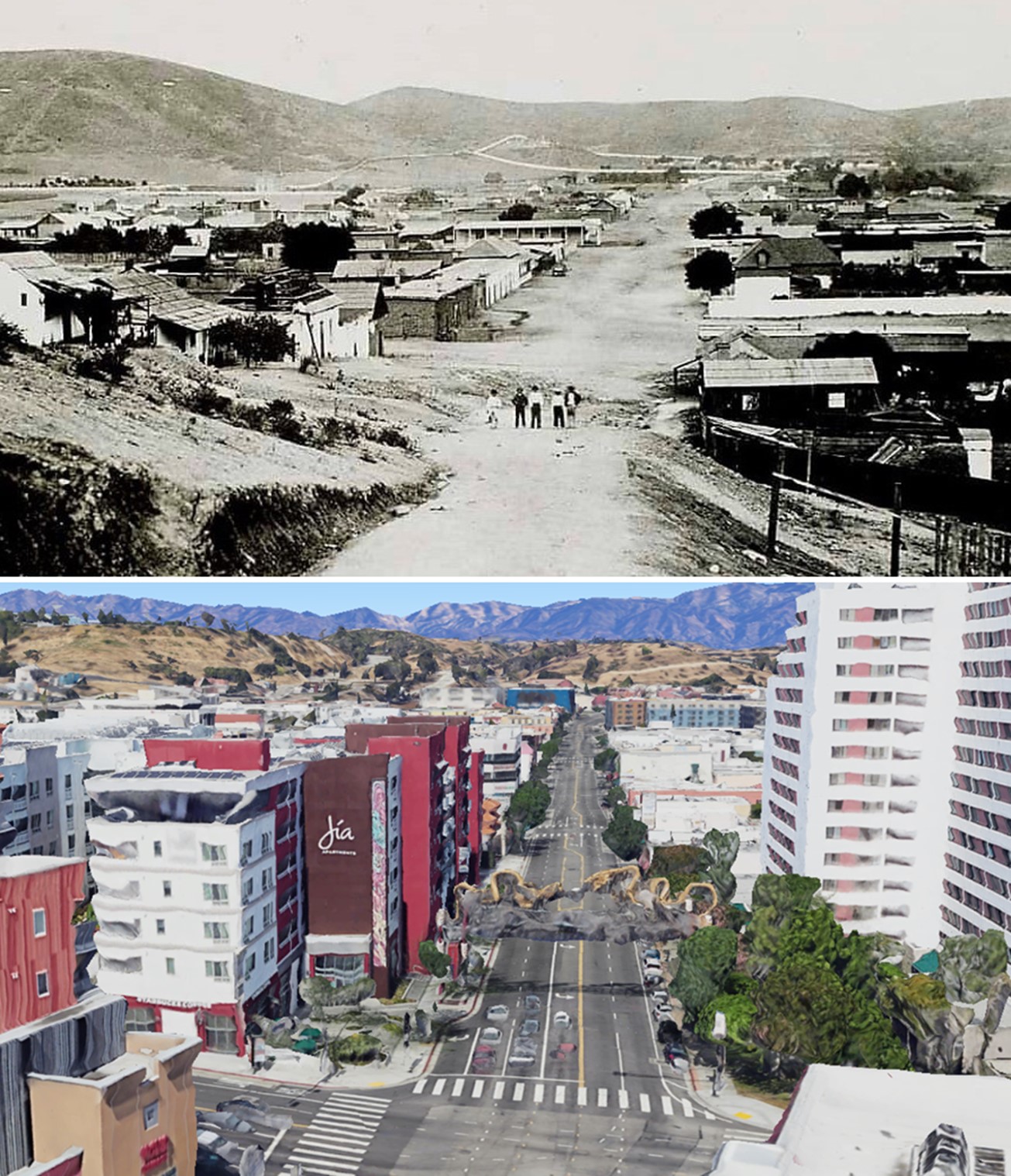
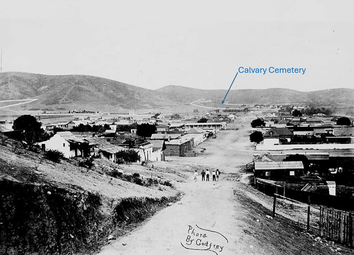
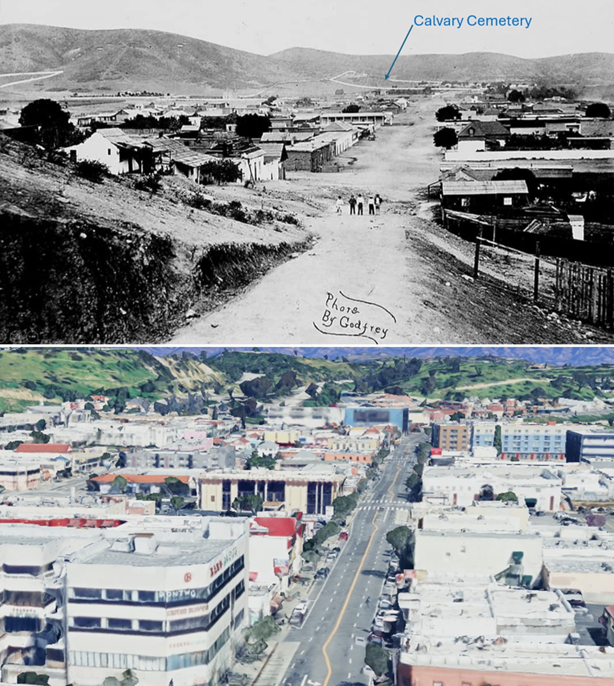
| (1870s)* - Looking northeast on Eternity Street (later North Broadway) in Sonora Town, as seen from Fort Moore Hill, with Calvary Cemetery visible in the distance. |
Historical Notes The burial ground visible in the distance had been receiving the dead of Los Angeles since 1844. Before Calvary Cemetery was established, most Catholic burials took place at the Campo Santo beside the Plaza Church on Main Street. As the city grew, church officials acquired land about a mile north of the Plaza for a larger cemetery at the mouth of the ravine later associated with Chavez Ravine. The new cemetery was blessed on November 2, 1844 — the Feast of All Souls — and later became known as Old Calvary Cemetery. Located at what was then the northern edge of town, it remained the principal Catholic burial ground for decades and eventually received an estimated 10,000 burials. Funeral processions traveled from the Plaza Church through Sonora Town along Calle Eternidad — Eternity Street — carrying the dead to their final resting place. This photograph captures the full length of that historic journey, from the city below to the cemetery at its distant end. |
 |
|
| (2023)* - Google Earth view looking north along Broadway toward Elysian Park and the former site of Calvary Cemetery, now home to Cathedral High School. |
Historical Notes By the late nineteenth century, Old Calvary Cemetery had become overcrowded and increasingly surrounded by urban growth. In 1895 Bishop Francis Mora acquired land east of the Los Angeles River for a new cemetery, and in 1896 the present Calvary Cemetery opened in East Los Angeles. Reinterment from the original cemetery continued over many years, although later discoveries suggested that not all remains had been relocated. One notable exception was the ornate iron tomb of Don Pío Pico, the last governor of Mexican California, and his wife María Ygnacia Alvarado, whose remains were eventually moved in 1921. One of the few surviving physical connections to the original cemetery remains nearby today — the historic chapel structure survives as part of St. Peter's Italian Catholic Church on North Broadway, preserving a tangible link to the street's earlier role as the road to eternity. |
Then and Now
 |
|
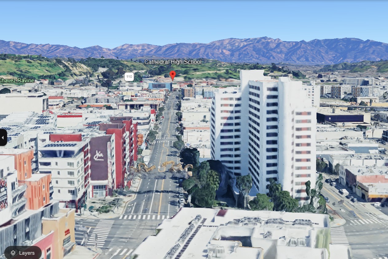
| (1870s vs 2023)* – Looking north on Eternity Street (today North Broadway) toward Calvary Cemetery, today the site of Cathedral High School. Photo comparison by Jack Feldman. |
Historical Notes Cathedral High School opened in 1925 on the former grounds of Old Calvary Cemetery after the Archdiocese arranged for the transfer of remaining burials to the new cemetery. The site's unusual history was never forgotten. Today the school's football field is known as "The Graveyard," and its teams carry the name "Phantoms" — enduring reminders of the land's earlier purpose. Portions of unearthed tombstones have been preserved on campus, and the grounds continue to reflect layers of Los Angeles history. The road once known as Eternity Street now carries modern traffic through Chinatown and into the city beyond. Its name disappeared long ago, but the route itself remains one of the oldest surviving paths linking the original pueblo to the northern edge of the city. Click HERE to continue exploring Early Views of Sonora Town. |
* * * * * |
Broadway between Temple and 1st Streets |
This early view looking south along Fort Street (later Broadway) captures Los Angeles during a pivotal period of transition. Open hillsides, unpaved roads, and scattered development reveal a city still expanding beyond its original Plaza-centered core. Within a few decades, the landscape shown here would be reshaped into one of downtown Los Angeles’ most recognizable urban corridors. |
 |
|
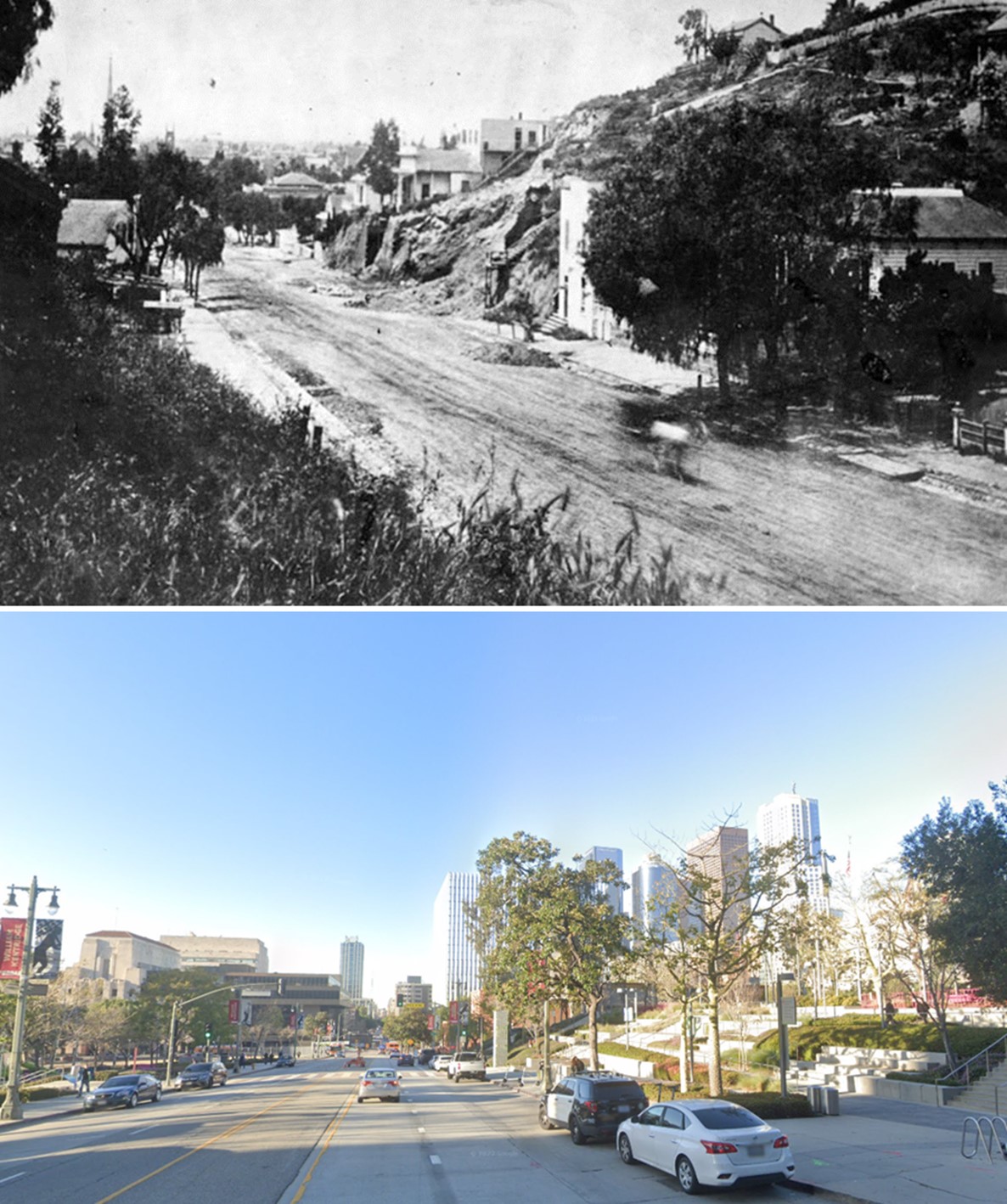
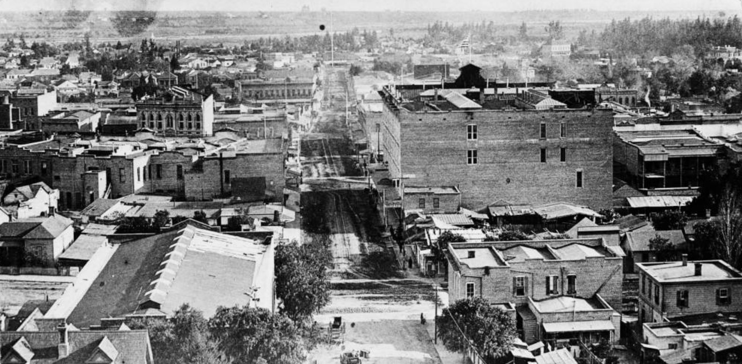
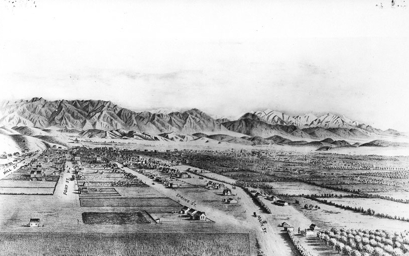
| (ca. 1874)* - View looking south southwest down Fort Street (renamed “Broadway” in 1890) between Temple Street (behind the camera) and 1st Street (beyond the first cut). Los Angeles High School stood just out of frame to the left (east) atop Poundcake Hill. The hill rising at right later became known as Bunker Hill, following development initiated by future Los Angeles Mayor Prudent Beaudry. |
Historical Notes By the early 1870s, much of the land west of Los Angeles’ original Plaza-centered core remained only lightly developed. This view captures an area that would soon become one of downtown Los Angeles’ defining corridors. The hill rising at right became known as Bunker Hill, one of Los Angeles’ earliest planned residential districts. Its transformation is closely associated with Prudent Beaudry, a French Canadian immigrant, businessman, and future Mayor of Los Angeles. In 1867, Beaudry acquired land atop the hill and envisioned an elevated residential community overlooking the growing city. To support development, he financed roads and installed a water system using steam-powered pumps to lift water from a lower reservoir to the hilltop. One of the streets Beaudry laid out was Bunker Hill Avenue, named in anticipation of the approaching centennial of the 1775 Battle of Bunker Hill. Over time, the name became associated with the entire hilltop neighborhood. In 1868, Beaudry and partners John Griffen and Solomon Lazard organized the Los Angeles Water Company, which later entered into a 30-year franchise agreement with the City to operate Los Angeles’ water system (1868–1898). Prudent Beaudry later served as the 13th Mayor of Los Angeles from 1874 to 1876. Click HERE to read more in Water in Early Los Angeles. |
Then and Now
 |
|
| (1874 vs 2023)* - Looking south on Broadway (formerly Fort Street) from near Temple Street. Broadway survived as one of Los Angeles’ historic north–south corridors while the surrounding terrain evolved into today’s Civic Center landscape. Photo comparison by Jack Feldman. |
Historical Notes This comparison illustrates one of the most dramatic physical transformations in downtown Los Angeles. In the 1874 photograph, Fort Street appears as a dirt roadway bordered by steep natural slopes and sparse development. The terrain visible at left occupied ground that today forms part of the broader Civic Center area and includes portions of what is now Gloria Molina Grand Park. Over the following decades, nearby Bunker Hill developed into one of Los Angeles’ premier residential districts before later undergoing extensive grading and redevelopment during the mid-20th century. Streets were widened, hills reshaped, and civic and commercial development altered the landscape shown in the original view. Although Broadway remains, the hills, open slopes, and early setting visible in 1874 were largely erased through grading and redevelopment, leaving little trace of the original landscape. |
* * * * * |
Broadway and 1st Street |
(Note: Broadway was known as Fort Street until 1890) |
This series of views traces the transformation of one of early Los Angeles’ most important intersections. During the late 19th century, First and Fort Street (later Broadway) evolved from a modest crossroads at the edge of the city’s original Plaza-centered core into an increasingly active commercial district.Within only a few decades, dirt roads, stables, and scattered buildings gave way to hotels, business blocks, and civic institutions. Together, these images preserve a rare visual record of downtown Los Angeles as it began to assume a more urban character. |
 |
|
| (ca. 1870)* - Looking east on First Street toward Broadway. |
Historical Notes This early view of First Street looking toward Fort Street dates to approximately 1870, when the intersection remained only lightly developed. Unpaved streets and open surroundings reflect Los Angeles’ modest scale before later growth transformed the area into one of downtown’s principal corridors. Today, little remains of the landscape shown here, making photographs such as this an important record of the city before large-scale commercial development reshaped its appearance. |
 |
|
| (ca. 1870)* - Looking east on First Street toward Broadway. (AI image enhancement and colorization by Richard Holoff). |
Historical Notes This enhanced and colorized version of the ca. 1870 photograph offers an interpretive view of the early Los Angeles streetscape. While the colors are modern reconstructions, the enhancement helps reveal details that may be less apparent in the original image, including the texture of the unpaved roadway, the surrounding terrain, and the scale of development along First Street. Colorization can provide a more immediate visual connection to the period while preserving the historical composition and context of the original photograph. |
 |
|
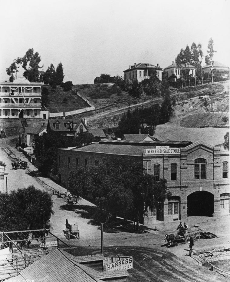
| (ca. 1874)* - View looking southwest at the intersection of 1st and Fort Street (later Broadway). The LA Times Building would be built on the northeast corner in the lower right. The sign on the wooden shed reads: “Livery and Feed Yard.” |
Historical Notes This ca. 1874 photograph captures the intersection during a transitional period in Los Angeles history. Although the setting still appears rural by modern standards, commercial activity was beginning to establish itself along Fort Street. The “Livery and Feed Yard” reflects the importance of horse transportation and support services in daily urban life. Within little more than a decade, this corner and the surrounding blocks would be transformed by hotels, commercial buildings, and increasing business activity as downtown expanded. |
 |
|
| (1884)* - Panoramic view looking east on First Street from Hill Street, showing the 4-story Nadeau Hotel located on the southwest corner of First and Spring streets. |
Historical Notes The dominant structure in this photograph is the Nadeau Hotel, completed in 1882 and considered one of Los Angeles’ earliest major luxury hotels. Rising above the surrounding streetscape, the hotel became an early symbol of the city’s growing economic ambitions. Other identifiable buildings include De Turk’s Livery, Feed & Sale Stable at lower left; the Larronde Block and Schumacher Block along Spring Street; Natick House at First and Main Streets; and the Pythian Castle Block visible north of First Street. Together, these buildings illustrate the increasingly urban and commercial character of downtown Los Angeles during the 1880s. |
 |
|
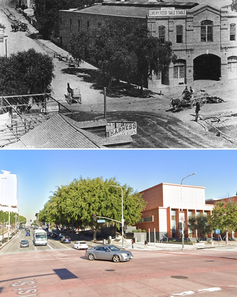
| (1886)* - View of the northwest corner of 1st and Broadway. Horses and carriages were common, as were the stables and liveries. The J. G. De Turk Livery Feed & Sale Stable later became the Tally Ho Stables. The site later housed the first home of the Chamber of Commerce. |
Historical Notes Visible at lower right is excavation work for the original Los Angeles Times Building, completed in 1887. At upper left stands Highland Villa at the northwest corner of First and Hill streets. This photograph captures a brief moment when horse-powered commerce and a more modern downtown existed side by side—a transitional landscape that would soon disappear as Los Angeles continued to urbanize. |
Then and Now
 |
|
| (1886 vs 2023)* – Looking at the northwest corner of Broadway and 1st streets. Photo comparison by Jack Feldman. |
Historical Notes This comparison illustrates how dramatically downtown Los Angeles changed over the following century. In 1886, the intersection was defined by stables, horse-drawn transportation, and low-rise commercial buildings serving a growing city. Successive redevelopment replaced nearly all of the early structures visible in the historic photograph. Although little survives from the original streetscape, Broadway continues to reflect its long-standing role as one of downtown Los Angeles’ defining commercial corridors. |
* * * * * |
Los Angeles Plaza Area (Then and Now)
 |
|
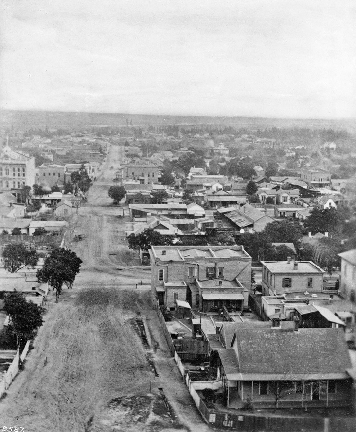
| (ca. 1858)* - This is the earliest known close-up photograph of the Los Angeles Plaza. There is a square main brick reservoir in the middle of the Plaza, which was the terminus of the town's historic lifeline: the Zanja Madre ('Mother Ditch'). The reservoir was built in 1858 by the LA Water Works Company. Click HERE to read more about the Zanja Madre and Los Angeles' first water supply. |
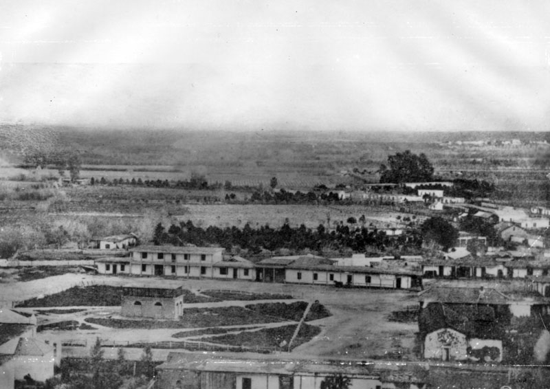
Historical Notes The site of the Plaza today is not the original location. It is the second, third, or maybe even the fourth. One of the earlier plots is believed to be around where the current Pershing Square sits. It’s also thought that at least one of the first three was washed away in a flood. The current Plaza dates from as early as 1815. When early settlers arrived at the Los Angeles River by way of Mission Road, they picked as a nearby gathering point a huge sycamore (upper right-center of photo) that gave them shelter and became a landmark, "El Aliso." That Spanish word for sycamore was later used to name the road carved out near the river (Aliso Street in 1854). El Aliso (upper center-right of photo) sprang from the ground near the western bank of the Los Angeles River in the late fifteenth century, about the same time Columbus arrived in the Americas. As it matured, the sycamore -- located at the juncture of the Los Angeles coastal plain and the San Fernando and San Gabriel valleys -- became a gathering place for Los Angeles' indigenous Tongva people. Local leaders traveled from their villages across Southern California to confer under the shade of the tree's canopy. By the mid-eighteenth century, the mighty sycamore stood at the center of one of the largest Tongva villages, Yangna. By the 1830s, due to the encroachment of the pueblo, El Aliso had ceased to function as the symbolic center of daily Tongva life as Yangna changed locations twice before dissolving into historical oblivion. |
 |
|
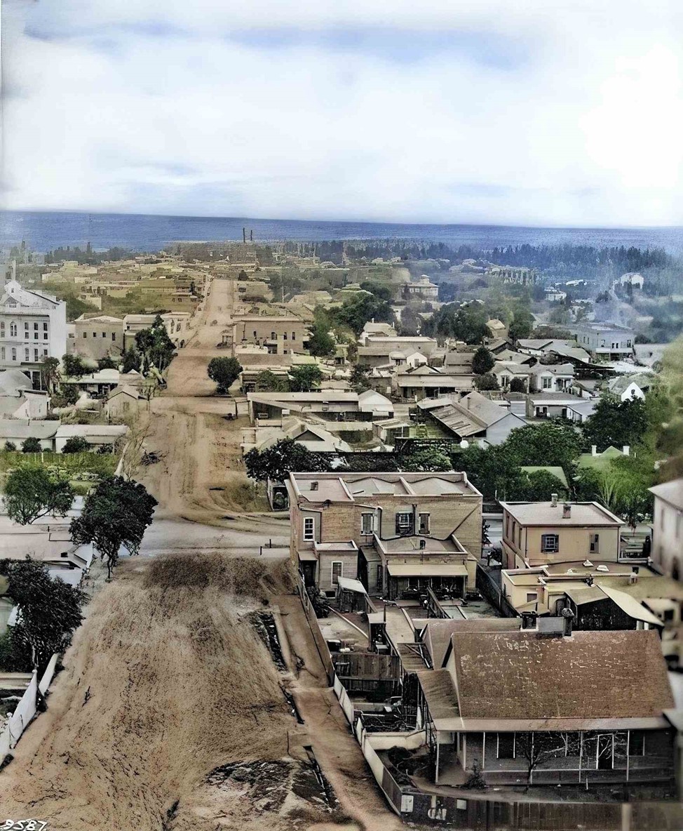
| (ca. 1858)* - This is the earliest known close-up photograph of the Los Angeles Plaza. There is a square main brick reservoir in the middle of the Plaza, which was the terminus of the town's historic lifeline: the Zanja Madre ('Mother Ditch'). The reservoir was built in 1858 by the LA Water Works Company. Image enhancement and colorization by Richard Holoff. |
Historical Notes Click HERE to read more about the Zanja Madre and Los Angeles' first water supply. |
 |
|
| (2023)* – Contemporary Google Earth view of the Los Angeles Plaza, now circular and surrounded by trees, government buildings, and Union Station. |
Historical Notes Though heavily modernized, the Plaza Church (just left of center) still stands as the oldest building on the site, dating to 1822. The former site of the Carrillo Adobe (demolished in 1870) is now occupied by the Pico House. |
Then and Now
 |
|
| (1858 vs. 2023)* – A 'Then and Now' view of the Los Angeles Plaza. Photo comparison by Jack Feldman. |
Historical Notes A few highlights for reference: The Plaza, once square, is now circular. In the lower-right of the 1858 image is the Carrillo Adobe, demolished in 1870 to make way for the Pico House. The Plaza Church, partially visible in the lower-left foreground of both images, is the only building still standing today. |
* * * * * |
 |
|
| (1869)* - View of Calle Principal (now Main Street) looking north with the Old Plaza Church seen on the left. To the right is the Los Angeles Plaza (square at the time) with two gas lamps, one on each of its corners. These were the first gas lamps installed in the City of Los Angeles. |
Historical Notes In 1867, Los Angeles Gas Company, the forerunner of today's Southern California Gas Company, installed 43 new gas lamps along Main Street, making the city safer at night. The gas lighting business was run by five entrepreneurs who manufactured the gas from asphalt, a tar-like substance, and later from oil. Click HERE to see more in Early Los Angeles Streetlights. |
 |
|
| (2015)* - Street view looking toward the Old Plaza Church on Main Street with the Los Angeles Plaza on the right. Note the ornate streetlamps. |
Historical Notes The 2015 view echoes the past while reflecting over a century of urban development. The Plaza remains a cultural centerpiece and historic landmark. |
Then and Now
 |
|
| (1869 vs 2015)* - A 'Then and Now' view of the Los Angeles Plaza and Calle Principal (Main Street). Photo comparison by Jack Feldman. |
Historical Notes These two images span nearly 150 years. The Old Plaza Church—present in both—remains a lasting symbol of the city’s origins. Gas lamps have been replaced by electric fixtures, and the unpaved Plaza is now a landscaped public space surrounded by urban infrastructure. |
* * * * * |
 |
|
| (1872)* - Looking south on North Main Street from in front of the Los Angeles Plaza and the Old Plaza Church showing the Pico House and, behind it, the Merced Theatre. In the distance can be seen the Temple Block where today's City Hall Stands. |
Then and Now
 |
|
| (1872 vs 2021)* – Looking south on Main Street from in front of the LA Plaza. Three buildings still exist today: The Pico House and the Merced Theatre on the left, and the Plaza Church on the right. In the distance of the early photo can be seen the Temple Block, current site of Los Angeles City Hall. Photo courtesy of Mark Frazier. |
Historical Notes Click HERE to see more Early Views of the 300 Block of Main Street. |
* * * * * |
 |
|
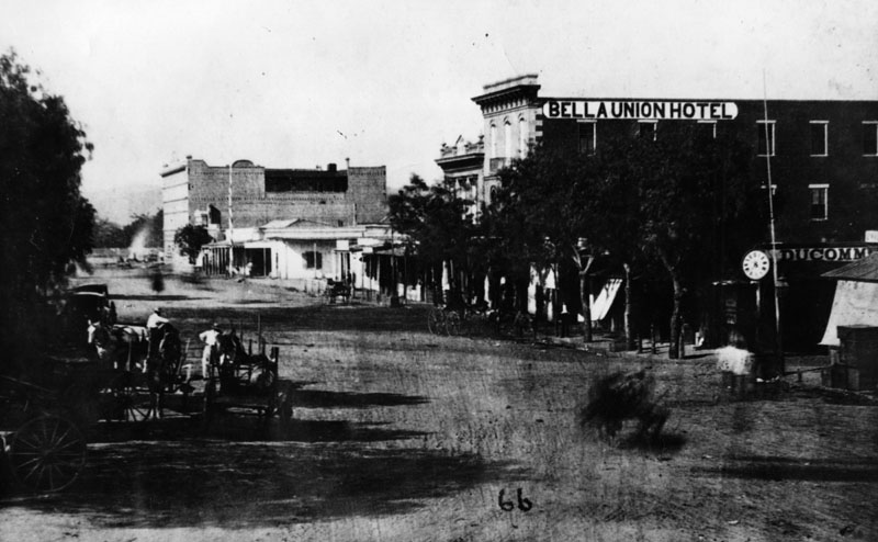
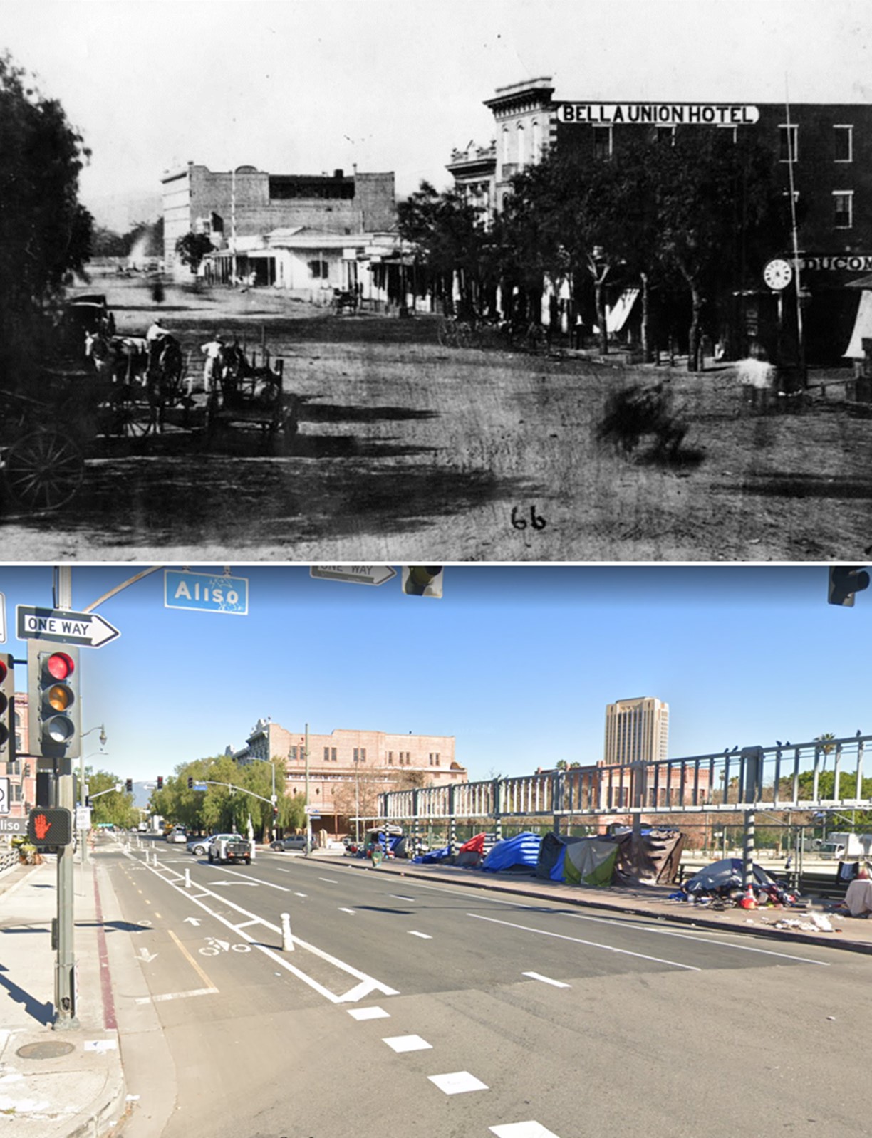
| (ca. 1870)* - Early view of the 300 block of North Main Street and beyond (view is looking North). Two large buildings stand out; the Pico House on the left and the Bella Union Hotel on the right. The Pico House is located one block north, across the street from the Los Angeles Plaza. It was built in 1870 by Pio Pico, the last Governor of Alta California under Mexican rule. Click HERE to see a Then and Now comparison of the above scene. |
Historical Notes The 300 block of North Main Street was an important part of Los Angeles history as early as the mid-1800s. It was considered the uptown commercial heart of the old city and was always buzzing with activity. Built there was Los Angeles’ first hotel, the Bella Union, which was long a social and political center. The first county courthouse was in the adobe hotel, where court was held in rented rooms from 1850 to 1852. Beginning in 1858, it was the region's transportation hub. The Overland Mail Company operated by John Butterfield (the founder of American Express) rented space for a station. The Wells, Fargo and Company also had their office here and Phineas Banning operated coaches to Wilmington and San Bernardino from the hotel. Just north of the two-story Bella Union was the Pico Building, built by Pio Pico in 1868 (two years before the Pico House). In 1871, the building became home to the Farmers & Merchants Bank, the first incorporated bank in Los Angeles. |
Then and Now
 |
|
| (1870 vs 2022) – Looking North on Main Street from Aliso Street in Old Downtown Los Angeles. Photo comparison by Jack Feldman. |
Historical Notes Click HERE to see more Early Views of the 300 Block of Main Street. |
* * * * * |
 |
|
| (1876)^ - Panoramic view of the Los Angeles Plaza on a very clear day. The Pico House is the prominent 3-story white building at the center of the photo. To its right stands the Merced Theatre. The LA River can be seen in the background. |
Historical Notes Pío Pico constructed the Pico House in 1869-70. The first three-story hotel built in Los Angeles, it had about eighty rooms, large windows, a grand staircase, and a small interior courtyard. In 1880, Pio Pico would lose the hotel by foreclosure. Also, between 1892 and 1920, the hotel would be known as the National Hotel. The Pico House (Hotel) was designated as California Historical Landmark No. 159. Click HERE to see California Historical Landmarks in LA. |
 |
|
| (1870s)^ - The Merced Theater sits between the Pico House and the Mason Lodge. This was the "first business block on Main Street". |
Historical Notes The Merced Theatre, erected in 1870 on North Main Street next to the Pico House, was the first building built expressly for theatrical purposes in Los Angeles. It was built by William Abbot, a cabinetmaker, and named in honor of his wife Merced Garcia. The theater was built in an Italianate style and operated as a live theater from 1871 to 1876. When the Woods Opera House opened nearby in 1876, the Merced ceased being the city's leading theater. Eventually, it gained an "unenviable reputation" because of "the disreputable dances staged there, and was finally closed by the authorities." The Merced Theatre was dedicated as California Historical Landmark No. 171 (Click HERE to see complete listing). It is also listed on the National Register of Historic Places. |
* * * * * |
LA's First Streetcars
 |
|
| (1874)^^ - A horse-drawn streetcar of the Spring & Sixth Railway in front of the Pico House (Note: the photo indicates 1870, however, that date does not align with historic records indicating first streetcar in 1874). |
Historical Notes L.A.'s first streetcars ran under horsepower. Steam locomotives were considered too dirty and dangerous for use on city streets still teeming with easily spooked horses, and cable car technology was still new and expensive. Electric-powered traction railways, meanwhile, remained more than a decade off. On July 1, 1874, the modest, horse-drawn cars of the Spring and Sixth Street Railroad became the first streetcars to roll down Los Angeles streets. Founded by lawyer Robert M. Widney, the Spring & Sixth operated a regular schedule, running cars hourly on weekdays between 6:30 a.m. and 10 p.m. For a ten-cent fare, passengers could ride the one-and-a-half-mile route from the intersection of Temple and Spring south to Sixth, and then west to Figueroa. Soon, L.A.'s streetcar network expanded as new railways opened and existing lines extended their tracks across the city. The Plaza functioned as a central hub for the city's growing streetcar network, with lines radiating out in several directions. Click HERE to see more on horse-drawn streetcars. |
 |
|
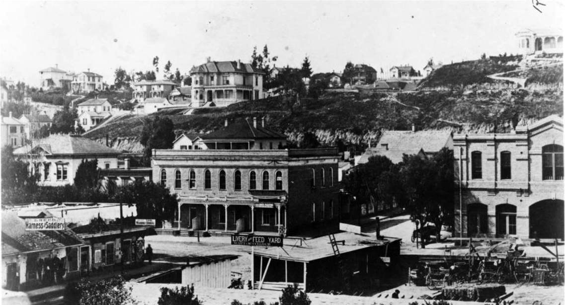
| (ca. 1877)^## – View looking southeast toward the Pico House with the LA Plaza on the left. Streetcar rails are seen on the dirt road. Note the gas street lamp on the left. |
Historical Notes In 1867, Los Angeles saw its first street gas lamps. A total of 43 were installed along Main Street. A lamplighter on horseback rode down the street at dusk to light the streetlights. By 1873, about 136 gas lamps provided the outdoor night lighting for the City. Things would change in 1882 when electricity was introduced. That year 3,000-candle power arc lamps were lifted atop seven 150-foot poles. The state of the art at that time encouraged the use of a few tall standards with high illumination. The gas street lamps would see their last days. Click HERE to see more in Early Los Angeles Streetlights. |
 |
|
| (1878)^ - The Pico House, sometimes called "Old Pico House", built by Pio Pico in 1869-70. Seen here from the Main St. entrance of the Plaza. The road in front and to the side of the building is dirt, and a set of tracks runs down the middle. The railway tracks were part of the East L.A. and San Pedro Street Railway. (Same as above but shows a portion of Main Street). |
Historical Notes The East Los Angeles & San Pedro Railway Company was founded by Judge Robert M. Widney (also one of the founders of the University of Southern California), this line was incorporated on May 1, 1875 but did not begin construction until March 1876. This horse car driven system ran north from Fourth Street and was intended to lay track to the new Southern Pacific depot. It reached only to College Street and North Broadway. The Pico House was designated California Historical Monument No. 159 (Click HERE to see complete listing). It is also listed on the National Register of Historic Places: NPS-72000231. Click HERE to see more in Early Views of the LA Plaza. |
* * * * * |
300 Block of North Main Street
 |
|
| (ca. 1878)^^ - View of the 300 block of N. Main Street looking south from near the LA Plaza. A horse-drawn wagon with two men in it is parked in front of the Pico House near the Merced Theatre on the left. The road is unpaved and a streetcar track runs down the middle. Both sides of the street are lined with imposingly large buildings. At center on the left side of the street is a very large ornate building topped by three prominent towers. It is the historic Baker Block. |
Historical Notes The 300 block of North Main Street was an important part of Los Angeles history as early as the mid-1800s. It was considered the uptown commercial heart of the old city and was always buzzing with activity. Built there was Los Angeles’ first hotel, the Bella Union, which was long a social and political center. The first county courthouse was in the adobe hotel, where court was held in rented rooms from 1850 to 1852. Beginning in 1858, it was the region's transportation hub. The Overland Mail Company operated by John Butterfield (the founder of American Express) rented space for a station. The Wells, Fargo and Company also had their office here and Phineas Banning operated coaches to Wilmington and San Bernardino from the hotel. Click HERE to see more in Early Views of the Historic 300 Block of N. Main Street. |
* * * * * |
Temple Block
 |
|
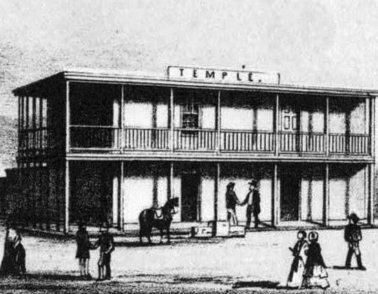
| (ca. 1850s)^^# - Sketch of John Temple’s original two-story adobe at the intersection of Spring, Main and Temple, which became known as Temple Block. |
Historical Notes In 1827, Jonathan Temple moved to the Pueblo de Los Angeles, where he opened the pueblo's first store, a business he operated for almost thirty years. Temple Street (Los Angeles) was developed by him as a modest one-block dirt lane in the 1850s. |
 |
|
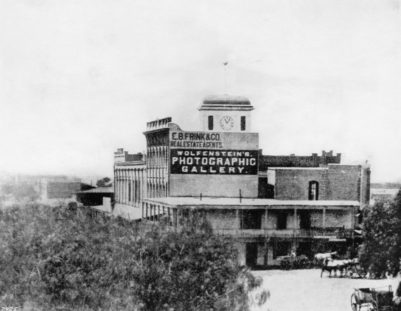
| (ca. 1872)^ - Temple Block exterior view looking south toward Temple Street from some point on the Main Street side of the buildings. John Temple's original two-story adobe can be seen as part of the Temple Block. |
Historical Notes The view above shows John Temple's 1858 Clocktower Market/Courthouse building and the first three buildings on the rest of Temple block. The original Temple Block structure is the two-story adobe at front (see photo above) at the intersection of Spring, Main and Temple. It was demolished by FPF Temple ("Tempelito"), John's half-brother, to build the new Temple Block building in 1871. "Temple Block" seems to be used to identify all of these buildings and also, only the one in front, facing the intersection (whether the old adobe Temple Block or the new Italianate Temple Block). |
 |
|
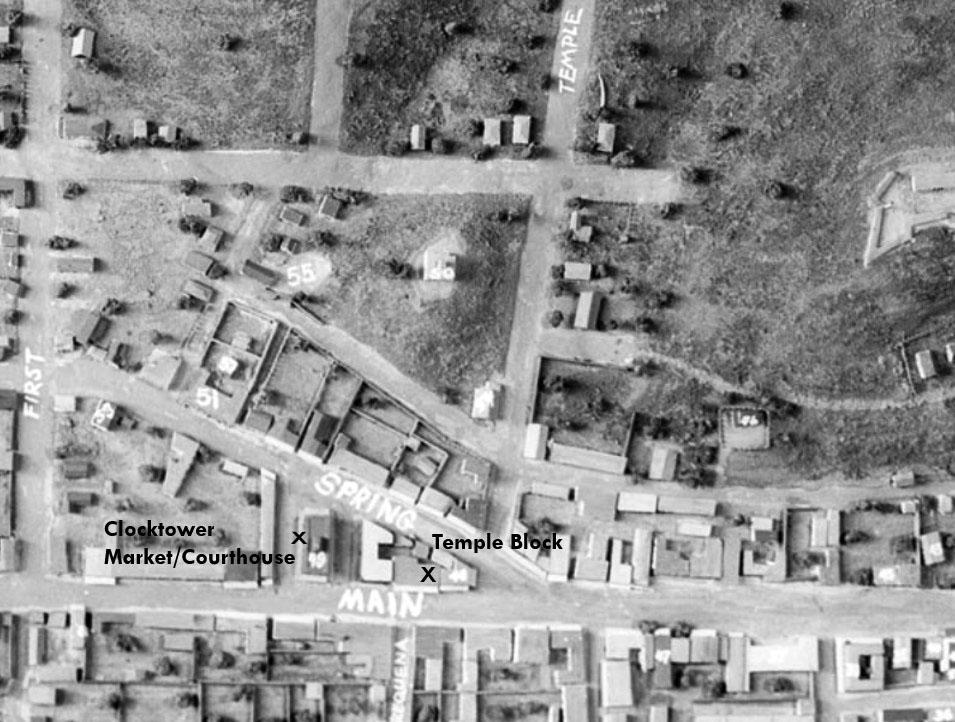
| (n.d.)* - Temple Square (Temple Block) appears at the bottom-center of this photograph of a model of old Los Angeles. John Temple's 1858 Clocktower Market/Courthouse building is also identified. This would become the future site of the current City Hall. |
Historical Notes Spring Street was realigned when construction of the new City Hall began in early 1927. Spring now runs parallel to Main, and intersects with Temple where the current 28-story City Hall building is now located. Click HERE to see more Early Views of the Original Temple Block |
* * * * * |
Temple Street
 |
|
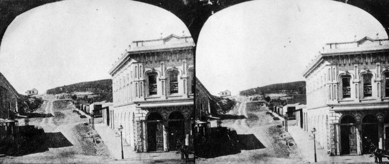
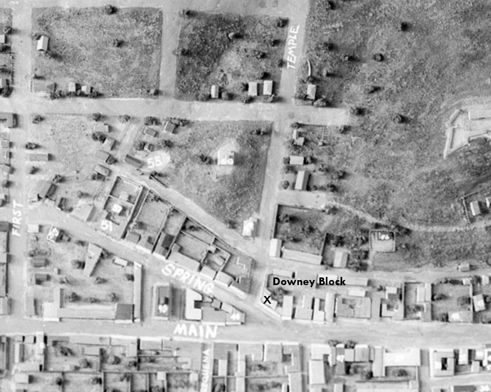
| (ca. 1870)^ - Stereographic card showing an unpaved Temple Street, looking west from Main Street. In the right foreground is the Downey Block located on the northwest corner. |
Historical Notes In 1827, Jonathan Temple moved to the Pueblo de Los Angeles, where he opened the pueblo's first store, a business he operated for almost thirty years. Temple Street was developed by him as a modest one-block dirt lane in the 1850s. |
 |
|
| (n.d.)* - Downey Block was located on the northwest corner of Main and Temple streets, highlighted at the bottom-center of the above model of old Los Angeles. Temple Street starts at the intersection of Spring and Main from where the Temple Block was built. |
 |
|
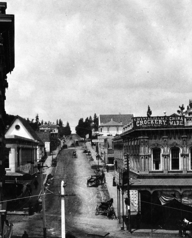
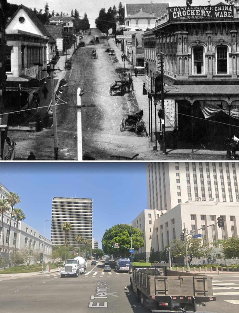
| (ca. 1884)* - View of an unpaved Temple Street, looking west as seen from the second floor of the Temple Block on Main Street. Horse-drawn carriages and wagons are parked along the street. In the right foreground is the Downey Block, housing the Crystal Palace, wholesale and retail sellers of crockery and china ware. Behind it is the Temple Street Stables. At left-center with ptiched roof and circular window is the St. Athanasius Episcopal Church located at the southwest corner of Temple and New High streets. Poles strung with electric/telephone wires are seen in the foreground. |
Historical Notes Temple Street here runs up a pretty steep hill (Poundcake Hill). Over the years the hill would be shaved down to accomodate new construction and an easier passage. Click HERE to see more Early Views of Poundcake Hill. |
 |
|
| (1870s)^## - View looking northeast from the top of Poundcake Hill showing the Downey Block (center) at Temple and Main streets. The building with the pitched roof in the foreground is St. Athanasius Episcopal Church. Across the street is the Temple Street Stables (lower-left). Also seen is the Temple Block at center-right. The Los Angeles River runs horizontally across the top of the photo and the wide street at upper left is Aliso Street where the 101 Freeway runs today. |
Then and Now
 |
|
| (1884 vs. 2022)* - Looking west on Temple Street at Main Street. Note how much the hill (Poundcake Hill) in the background has been shaved down over the years. Photo comparison by Jack Feldman. |
Historical Notes Click HERE to see more Early Views of Poundcake Hill. |
* * * * * |
Main Street in the 1870s, North of Temple Street
 |
|
| (ca. 1870)* — View of wagons in front of shops on the west side of Main Street, north of Temple Street. The Lafayette Hotel appears at the far right, identifiable by its chimney. Houses on Fort Moore Hill rise in the background. Store signs include “Harris and Jacoby, Successors to H. W. Hellman” and “M. Kremer.” |
Historical Notes This view shows Main Street when it was still unpaved and dominated by horse drawn traffic. The businesses along the west side served merchants, travelers, and nearby residents. The Lafayette Hotel was one of several early lodging houses catering to visitors arriving by stage and rail. Fort Moore Hill, seen behind the shops, was an early residential and military landmark that later disappeared as downtown expanded and streets were regraded. |
 |
|
| (1873)* - View looking north on Main Street near Temple Street. The Downey Block, located at the northwest corner of Main and Temple streets, is visible on the left. |
Historical Notes The Downey Block was one of the most important commercial buildings in early Los Angeles. Its second floor housed the photography studio of Henri Penelon, who documented the city during its formative years. The Lafayette Hotel stands just beyond it, marked by a chimney. In the far distance is the belfry of the Plaza Church. In 1873, Los Angeles organized its Chamber of Commerce and opened its first public library nearby, signaling the city’s transition from frontier town to organized municipality. |
 |
|
| (1871)* - First civic parade in Los Angeles, July 4, 1871. Volunteer firemen follow a horse drawn cart carrying a pressurized water pump. The view looks north at the intersection of Main, Spring, and Temple streets, with the Downey Block on the left. |
Historical Notes Public celebrations such as this parade were important expressions of civic pride in early Los Angeles. The volunteer fire department played a central role in public life, as fires were a constant threat in a city built largely of wood. The Downey Block’s prominent location made it a frequent backdrop for parades, speeches, and gatherings, reinforcing its role as a civic landmark. |
 |
|
| (ca. 1871)* - North Main Street, looking north from Temple Street. The Downey Block stands on the northwest corner at left. In the upper right is the Bella Union Hotel, considered the first hotel in Los Angeles. Horse drawn wagons crowd the foreground. |
Historical Notes This image illustrates the congestion and activity of Temple Square, the commercial and transportation center of the city. The Bella Union Hotel served travelers, politicians, and businessmen and was closely tied to the city’s early social life. The heavy wagon traffic reflects Main Street’s role as a supply route linking farms, ranches, and regional trade with downtown businesses. |
 |
|
| (ca. 1875)* - View showing the Main Street side of the Downey Block, with Temple Street at left. Two well dressed men stand on the dirt roadway in front of the building. |
Historical Notes By the mid 1870s, the Downey Block symbolized stability and success in a growing city. The men’s clothing reflects rising prosperity and a more established business class. The block housed a variety of offices, shops, and services that attracted professionals and merchants and helped define Main Street as Los Angeles’s primary commercial corridor. |
 |
|
| (1878)* - View looking north on Main Street from in front of the Temple Block. The Downey Block is on the left at the northwest corner of Main and Temple streets. In the distance stands the ornate Baker Block with its rooftop towers. |
Historical Notes The Baker Block, completed around 1877, represented a new level of architectural ambition in Los Angeles. Its height and ornamentation reflected confidence in the city’s future. Over time it housed offices, shops, and apartments. The eventual demolition of both the Baker Block and surrounding structures made way for U.S. Route 101, permanently altering this historic area. |
|
|
| Model of downtown Los Angeles in the 1870s, showing the location of the Downey Block at the northwest corner of Main and Temple streets.* |
Historical Notes This model helps place the Downey Block within the broader landscape of 19th century Los Angeles. The intersection of Main, Spring, and Temple streets formed Temple Square, the city’s commercial and civic heart. The Downey Block anchored this area and supported dozens of businesses, contributing to the development of downtown as the economic center of Southern California. Click HERE to see more early view of the Downey Block. |
Then and Now
.jpg) |
|
| (1873 vs. 2024)* — Main Street looking north from near Temple Street, showing the Downey Block at left, now the site of the U.S. Courthouse. Photo comparison by Jack Feldman. |
Historical Notes This view compares Main Street in 1873 with the same location in 2024. In the earlier image, the Downey Block stands on the northwest corner of Main and Temple streets. At the time, this area was the center of business and daily life in Los Angeles, with unpaved streets, horse drawn wagons, hotels, shops, and nearby civic buildings. Today, the Downey Block is gone and the site is occupied by the United States Courthouse. The change reflects how downtown Los Angeles evolved from a small commercial district into a center of government and public institutions. Over time, many early buildings were removed as streets were widened and the area was rebuilt to serve new uses. Seen together, the images show how Main Street has changed in appearance and purpose while remaining an important part of the city’s history. |
* * * * * |
Main Street in the 1870s, South of Temple Street
.jpg) |
|
| (1873)* - View looking south on Main Street from Temple Street during a Fourth of July parade. Horse drawn vehicles and spectators line the street as the procession passes through the area near the Temple Block. |
Historical Notes Fourth of July parades were major civic events in early Los Angeles and often followed routes through the city’s most important commercial and governmental areas. South of Temple Street, Main Street passed directly alongside the Temple Block, which housed city and county offices and served as a focal point of public life. Parades moving through this area symbolized civic unity and local pride. The scene reflects how public celebrations, government functions, and daily commerce overlapped in the heart of the city during the 1870s. |
* * * * * |
Downey Avenue Bridge
 |
|
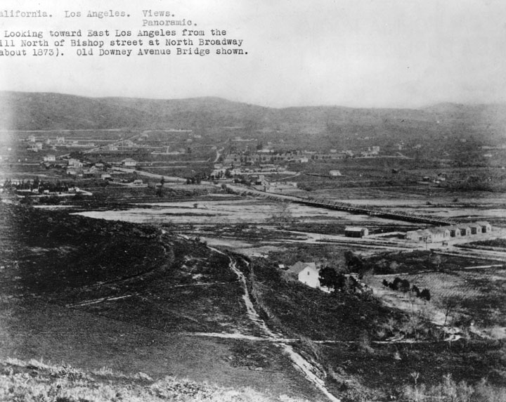
| (ca. 1883)^ - View looking toward Boyle Heights and East Los Angeles from the hill north of Bishop Street at North Broadway. The Old Downey Avenue Bridge (now North Spring St.) across the Los Angeles River is seen at center. |
 |
|
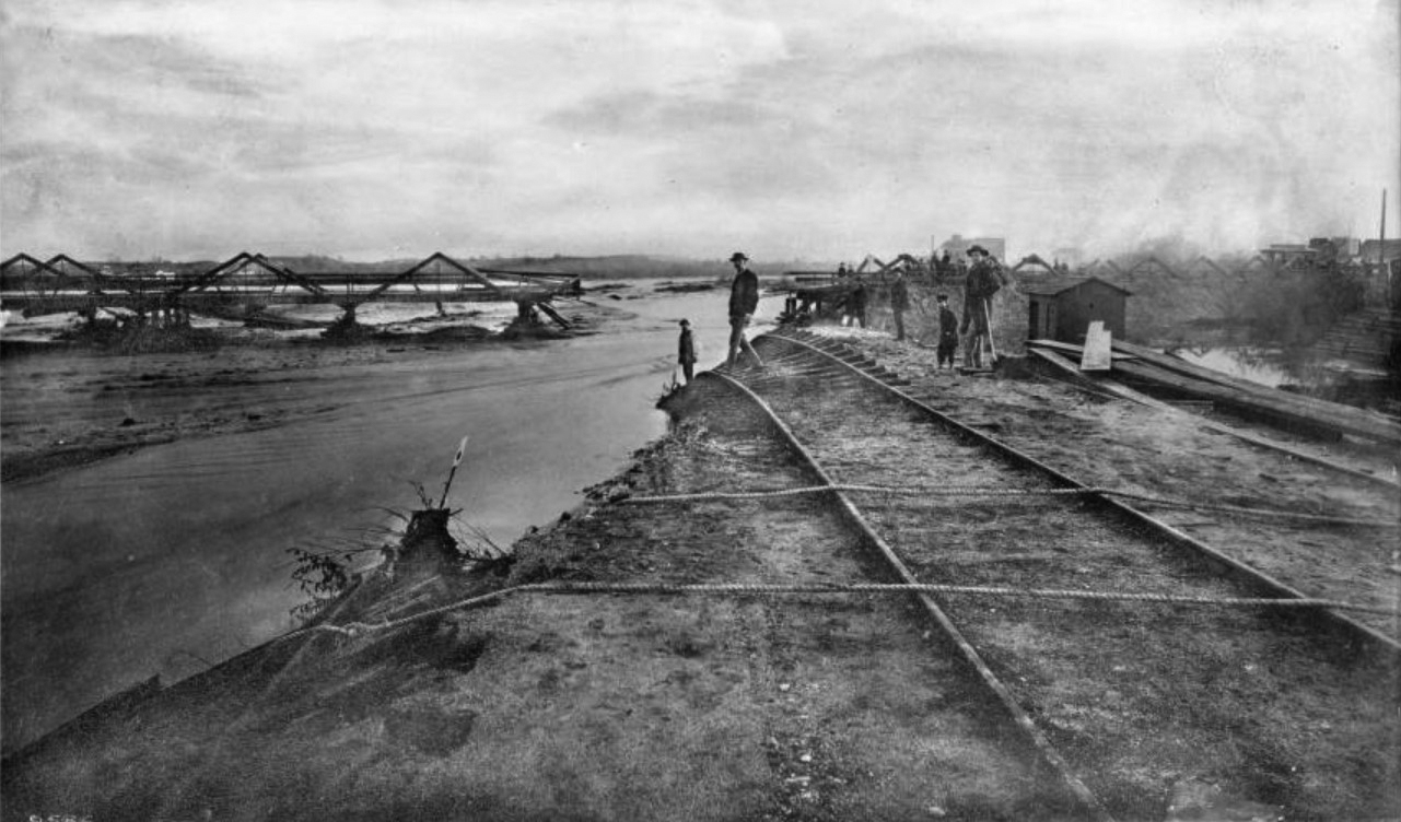
| (1886)* - View showing the flood damage to the Santa Fe tracks on the old Downey Avenue Bridge (later North Broadway) during the Los Angeles flood of 1885-1886. Several people are standing in front of a lumber pile and shed, near the washed-out Santa Fe tracks on the banks of the Los Angeles River. In the foreground, two large ropes cross the tracks and continue down to the river, where one rests on a pile of debris. Across the water, the damaged Downey Avenue Bridge can be seen, and a streetcar is at the extreme right of the picture. |
Historical Notes In 1886, the LA River washed out the adjacent tracks of the Santa Fe Railroad. The Downey Avenue Bridge, visible in the background, was also destroyed. Click HERE to see more in Los Angeles River the Unpredictable. |
* * * * * |
Boyle Heights
 |
|
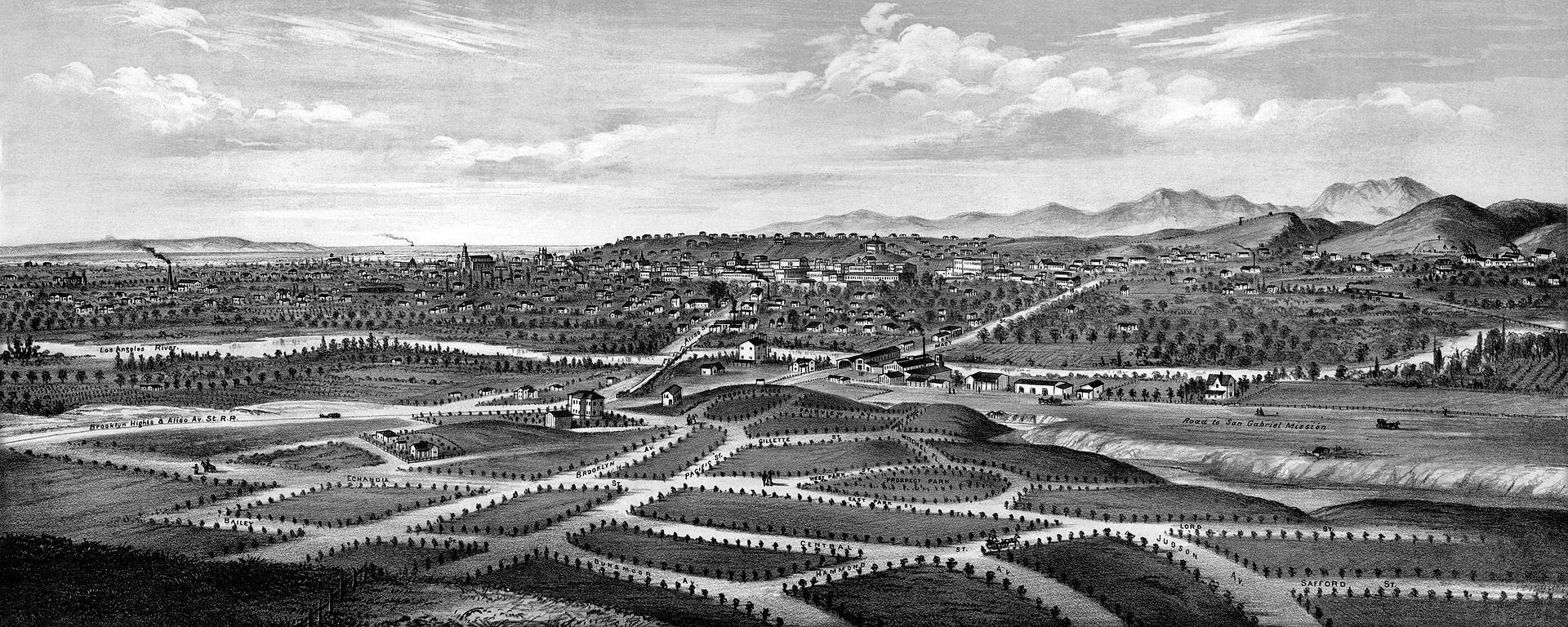
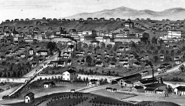
| (1877)* - Drawing by E.S. Glover showing Boyle Heights with the Los Angeles River across the center and Los Angeles city in the background. The Aliso Street Bridge can be seen at center with the Macy Street Bridge to its right. |
_CROPPED.jpg)
Historical Notes In 1858, Andrew Boyle purchased land on Paredon Blanco, planted vineyards, and built a home on what became Boyle Avenue. The area was once called Paredon Blanco (White Bluff) when California was part of Mexico. In 1875, William H. Workman subdivided the area east of the Los Angeles River for residential development and named it "Boyle Heights" in honor of his father-in-law, who he inherited the land from. |
 |
|
| (1877)* - Detail of previous drawing, showing the city's first bridge, Macy Street Bridge on the right and the later Aliso Street bridge on the left. The view looks west toward downtown Los Angeles from Boyle Heights. |
 |
|
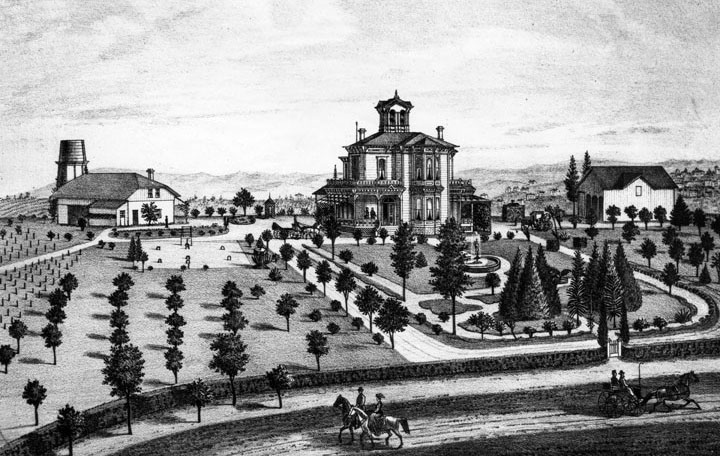
| (ca. 1880)^ - Engraving of the "Villa de Paredon Blanco," Residence of J.E. Hollenbeck, in Boyle Heights, 1-1/4 miles southeast of downtown Los Angeles. |
Historical Notes In 1874, John Edward Hollenbeck and his wife visited Los Angeles. The community was growing rapidly, and businesses were investing heavily in anticipation of the coming of the Southern Pacific Railroad. While visiting California, Hollenbeck, who made his wealth in Nicaragua, purchased several parcels of real estate and deposited funds in Temple and Workman Bank. Hollenbeck soon closed out his Nicaraguan businesses and made his final move to the United States. Arriving in Los Angeles early in the spring of 1876, Hollenbeck purchased land on the east side of the Los Angeles River, and built a large residence with broad verandas and a tower on extensive grounds on Boyle Avenue. He made twenty-seven acquisitions of property by 1880; spending $108,875 for a total of 6,738 acres. The real estate holdings included 600 acres south of the city limits, much of which was planted in vineyards. In the San Gabriel Valley, he owned orchards of oranges, lemons, and grapes; and invested in 3,500 acres of Rancho La Puente — a grain and stock ranch. In 1884 he purchased and developed an urban business district, known as the Hollenbeck Block, within Los Angeles. Hollenbeck was elected to the Los Angeles Common Council, the governing body of the city, on December 3, 1877, for a term ending on December 6, 1878. In 1878 Hollenbeck became a stockholder in the Commercial Bank of Los Angeles, and was elected its president. In 1881, he and other investors organized and established the First National Bank. |
* * * * * |
Main, Spring, and 9th Streets
 |
|
| (ca. 1873)* - Drawing of Los Angeles as it appeared circa 1873. View looking North from the junction of Main, Spring, and 9th Street. |
Historical Notes The junction of Main, Spring, and 9th streets, seen at lower-right, has beeen one of the most photographed intersections in the City. Click HERE to see more. |
* * * * * |
Main and 10th Street (Elijah Workman Home)
 |
|
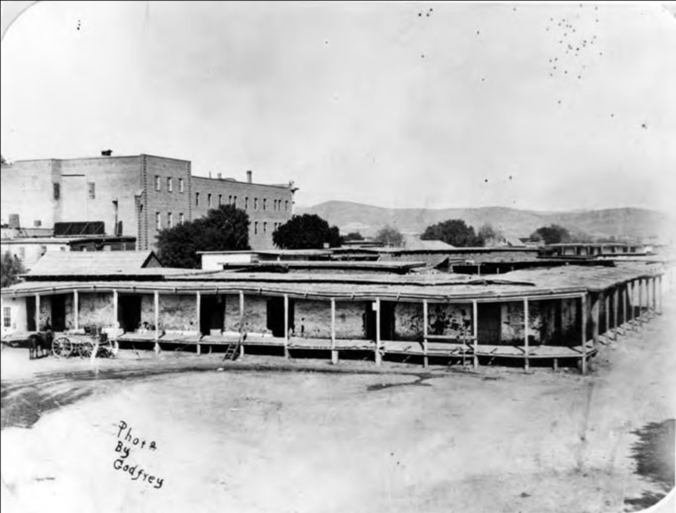
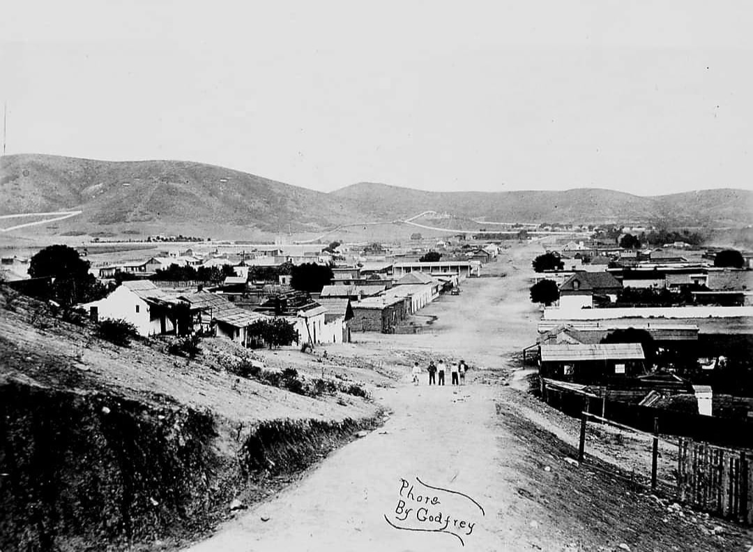
| (ca. 1870)* - This early photo captures the one-story home of Elijah Workman, built on his 40-acre farm bounded by Main Street, Broadway, 10th Street, and 11th Street. Looking north, Main Street stretches into the heart of Los Angeles, with Spring Street branching off to the left at 9th Street, visible in the upper right of the photo. Photo by W.M. Godfrey (Ernest Marquez Collection). |
Historical Notes Much of the young city—then home to about 6,000 residents—is visible beyond the house. Straight behind the peak of the roof, the white clocktower of the County Courthouse atop the Temple Block rises prominently—one of the most recognizable landmarks of early Los Angeles. To the far left, St. Vincent’s College can be seen near the newly created Central Park (later renamed Pershing Square). |
 |
|
| (2024)* - Contemporary view looking north from above where Elijah Workman's house once stood. |
Then and Now
 |
|
| (1870 vs. 2024)* – A "Then and Now" comparison looking north from 11th Street between Broadway and South Main Street toward the heart of downtown Los Angeles. The early photo shows Elijah Workman's farmhouse and farmland, with the young city just beginning to emerge in the distance. If you look closely, you can spot the white clock tower of the County Courthouse atop the Temple Block—the site where today's Los Angeles City Hall now stands. Photo comparison by Jack Feldman. |
* * * * * |
Main Street and 11th/12th Street (Ozro Child House)
 |
|
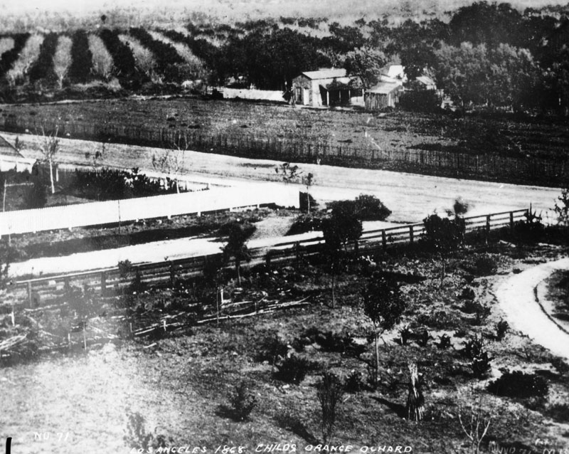
| (1868)^ - View of Ozro Childs' orange orchard in 1868 at the corner of Main and 12th Streets. The Childs Residence was located at 1111 S. Main Street. |
Historical Notes Ozro W. Childs obtained the contract to build an extension of the Zanja Madre, a canal system to bring water to the fields south of the pueblo. He was paid in land in that area – all now within present day Downtown Los Angeles - from Sixth to Ninth, and Main to Figueroa Street. Click HERE to see more in Zanja Madre - LA's Original Aqueduct. This property was the foundation of his fortune. He built a substantial house at 10th and Main, then a half-mile from town center, and on his property took up planting. In his day, Ozro Childs was Los Angeles’s most prominent plantsman, with a Plant nursery. Childs was also involved in philanthropic work. When Judge Robert Maclay Widney set out to create a university in Los Angeles in the 1870s, he received assistance from donors including Childs. In 1879, Childs contributed a considerable amount of land to the founding of the University of Southern California, which opened in 1880. |
 |
|
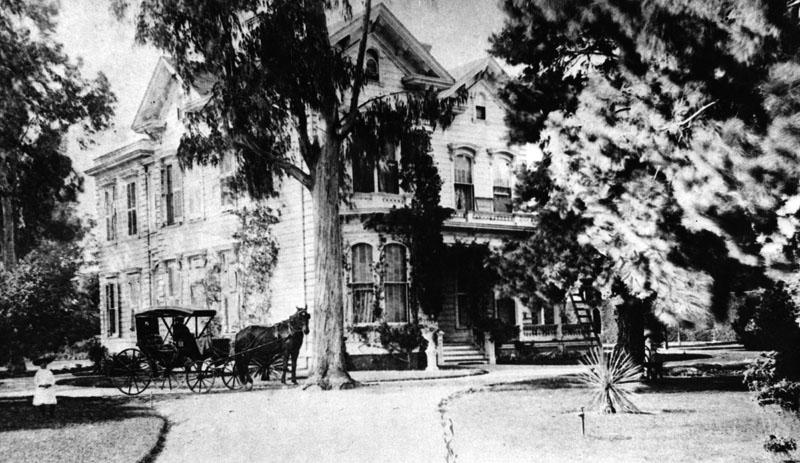
| (ca. 1880s)* - View of Ozro W. Childs’ house located at 1111 S. Main Street. The photo shows the exterior front of the house, with a horse-drawn carriage next to a tree, as well as a child wearing a white dress and hat to the left of the picture. |
Historical Notes Childs was also involved in philanthropic work. When Judge Robert Maclay Widney set out to create a university in Los Angeles in the 1870s, he received assistance from donors including Childs. In 1879, Childs contributed a considerable amount of land to the founding of the University of Southern California, which opened in 1880. |
* * * * * |
Early Downtown
 |
|
| (ca. 1874)#^ - View looking south on New High Street in downtown Los Angeles, towards the intersection with Temple Street. The steep roof of St. Athanasius Episcopal Church can be seen at the intersection with Temple Street at right and the side of a two-story building with the sign "Furniture & Bedding" can be seen, located on Spring Street. Further back can be seen a large building. This was Congregation B'nai B'rith, LA's first Synagogue. |
 |
|
| (1874)^ - View looking south on Spring Street from the Temple Block. The large building in the distance is the the first Jewish Synagogue in Los Angeles. At lower left hand is the first office of the Evening Express in the Temple Block. Note the tracks running down the center of Spring Street. |
Historical Notes 1873 marked the dedication of Los Angeles' first Synagogue, erected by Congregation B'nai B'rith on Fort Street (now Broadway) between 2nd and 3rd Streets. The site now is marked by a commemorative plaque.*+ |
 |
|
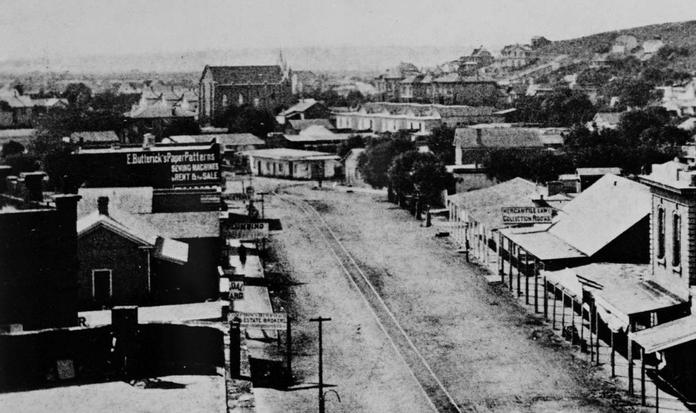
| (1874)+^ – Close up wide-angle view looking south on Spring Street. To the right of center is a building with a steep roof and a sign that says “Mercantile Law Collection Books.” The building immediately south of that, on the northwest corner of Spring and Franklin Streets, is the first Los Angeles City Hall, a building the city and county shared. The taller building in the distance, near the top center of the photo, is the City's first Synagogue, built in 1873. |
Historical Notes In August 1853, an adobe home that had been built in the 1820s at the northwest corner of Spring and Franklin Streets – a site now under the current city hall – was sold by John Temple to the city and to Los Angeles County for a city hall and courthouse. The city owned a one-quarter interest in the property, and the county owned a three-quarters interest. A brick jail used by both the city and county was constructed behind the adobe in 1853-54, the first (non-adobe) brick building built in Los Angeles.+^ Click HERE to see more early views of Los Angeles' first City Hall & Jail. |
.jpg) |
|
| (ca. 1875)^ - View looking south on Main Street from near the Bella Union Hotel showing Temple Block and the Downey Block at the junction of Main Street with Spring and Temple streets (upper-left). Livery stables appear on both sides of Main Street in the foreground. The tracks of the Main Street and Agricultural Park Street Railroad run down the center of the street. |
Historical Notes The Main Street and Agricultural Railroad was the first suburban line in Los Angeles and was chartered in November 1874. The line operated through the city on Main Street to Washington Boulevard and extended to Agricultural Park (now Exposition Park), traveling by way of Washington, Figueroa, and Wesleyan (now University Avenue).*## Financed by John Downey, Isaias Hellman, William Workman, and others, the Main Street and Agricultural Park Street Railroad connected the city's business district near Temple Street to Agricultural Park, a haven for gamblers and vice-seekers. The park, outfitted with a racetrack, saloon, and brothel, was rechristened Exposition Park in 1913.*^^* |
 |
|
| (Early 1870s)^ - San Pedro Street, a muddy dirt street, near 2nd Street in the early 1870s. A gas lamp post can be seen surrounded by a puddle of water. |
Historical Notes In 1873, about 136 gas lamps provided the outdoor night lighting for the City of Los Angeles. That would change in 1882 when electricity was introduced and Los Angeles saw its first electric streetlights being installed (Click HERE to see more in Early L.A. Streetlights). |
* * * * * |
Vermont and Melrose
 |
|
| (ca. 1874)^ - Farmer Dennis Sullivan farms a section of land where L.A. City College presently stands, on Vermont Ave. The location was the site of UCLA until the university moved to Westwood. Click HERE to see more Early Views of UCLA. |
* * * * * |
Los Angeles and Independence Railroad Company
 |
|
| (1875)^ - 3rd Street, looking east in 1875. There is a small residential area, beyond which are farms and orchards. In the right distance can be seen the newly built Los Angeles and Independence Rail Road Terminal at Fifth Street and San Pedro Street. |
Historical Notes The Los Angeles and Independence Railroad Company was incorporated in January 1875 with Francisco P. Temple, John P. Jones, Robert S. Baker, T. N. Park, James A. Pritchard, J. S. Slauson, and J. U. Crawford, as directors. Col. Crawford was the engineer and general manager. The 16.67 miles of track between Los Angeles and Santa Monica were privately built without government subsidies or land grants, all in a little over ten months - primarily using 67 Chinese laborers imported for the task. Right-of-way between Los Angeles and Santa Monica was given by local ranchers who were anxious to have access to a railroad. The line opened October 17, 1875, with two trains a day running between Santa Monica and Los Angeles; the fare was fixed at $1.00 per trip, freight at $1.00 per ton.*^ |
 |
|
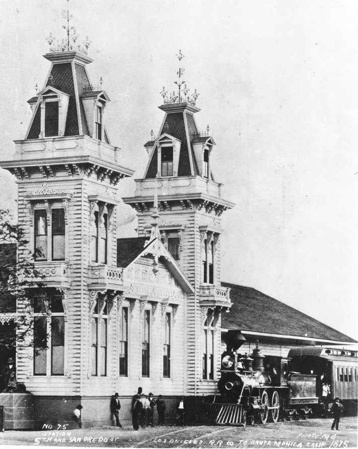
| (1875)^^ - View of a steam locomotive in front of the Los Angeles and Independence Rail Road Terminal at Fifth Street and San Pedro Street, 1875. Two lavishly decorated brick towers extend from the main building to either side of its entrance. |
 |
|
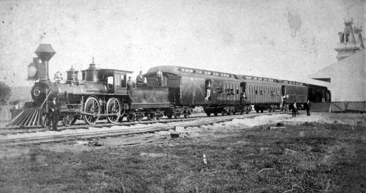
| (1876)* – View showing Locomotive No. 1 and passenger cars of the Los Angeles and Independence Railroad on train tracks next to the railroad's terminal at Fifth Street and San Pedro Street in Los Angeles. The train is full of passengers and is about to leave for Santa Monica. |
Historical Notes Opposition to continued construction east of Los Angeles by Southern Pacific Railroad's refusal to allow crossing of their main line tracks, and the unexpected depletion and closure of the Panamint silver mine in 1877 (owned by John P. Jones), led to severe fiscal difficulties for the young steam line. On July 4, 1877 the Los Angeles & Independence was acquired by Southern Pacific. Click HERE for more on the Los Angeles and Independence Railroad. |
* * * * * |
Santa Monica
 |
|
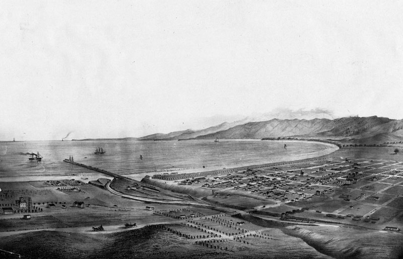
| (1875)* - View of Santa Monica and bay showing the road and wharf of the Los Angeles & Independence Railroad, about 1875. The wharf was completed in 1875 and sold in June 1877 to the Southern Pacific Railway Company, This print was photographed from an old lithograph. |
Historical Notes The new railroad made Santa Monica accessible to Angelinos. Tourists began to visit and the town grew and prospered. By November 1886, the electorate went to the polls and voted 97 to 71 to incorporate Santa Monica. |
 |
|
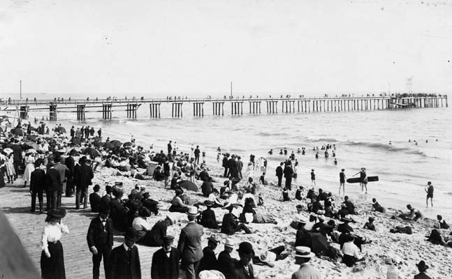
| (1880)* - View of the pier and beach in Santa Monica in 1880. People are walking on the boardwalk, sitting on the beach, and enjoying the surf. This was considered casual attire in the 1800s. |
Historical Notes In the mid-1880s, tourism in Santa Monica was booming. Roughly 2,000 to 3,000 tourists visited Santa Monica in the summer of 1887. This was not the same pier as today's Santa Monica Pier. Several others would be built after this one. Click HERE to see more in Early Views of Santa Monica |
* * * * * |
Sisters of Charity
 |
|
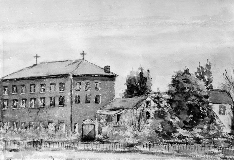
| (1860)^ - Photo of a watercolor painting of the first school (and Sisters of Charity Orphanage) in Los Angeles, made in 1860 by a student. |
Historical Notes The Los Angeles Orphan Asylum, originally called the Los Angeles Charitable Institute and later known in Spanish as Casa de las Hermanas, was established in 1856 by the Daughters of Charity of St. Vincent de Paul. Seeking to provide care for the growing number of orphaned and destitute children in the young pueblo, the Sisters purchased property from Benjamin D. Wilson, an early mayor of Los Angeles. The parcel, located at the corner of Alameda and Macy Streets (now Cesar E. Chavez Avenue), included roughly twelve acres of land and Wilson’s old wood-frame house, which had originally been shipped around Cape Horn. The Sisters bought the property for $8,000, a significant investment at a time when Los Angeles was still little more than a dusty frontier town. |
 |
|
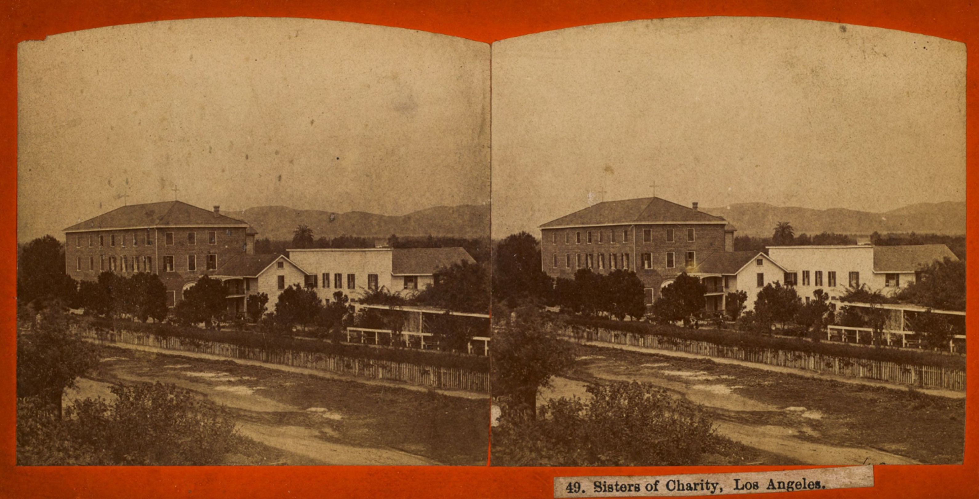
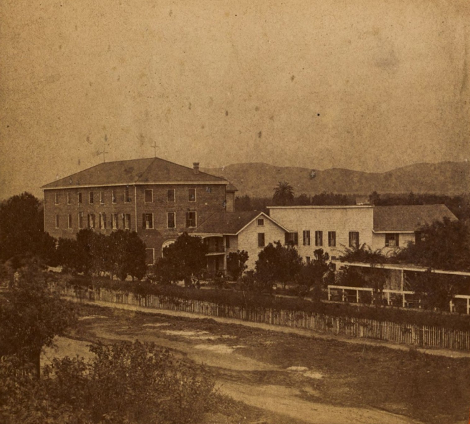
| (ca. 1868)* - Stereoscopic image showing the property of the Daughters of Charity of St. Vincent de Paul (also known as the Sisters of Charity), as seen from across Alameda Street near Macy Street (now Cesar E. Chavez Avenue). Visible is the Los Angeles Orphan Asylum and School, initially called the Los Angeles Charitable Institute. Photo by William M. Godfrey from the Ernest Marquez Collection. |
Historical Notes The Wilson house initially served as the Sisters' residence and the first orphanage quarters. However, recognizing the need for a more permanent facility, the Sisters quickly set about constructing a new building. By 1858, a large three-story brick structure—one of the first of its kind in Los Angeles—was completed, using bricks and building materials also brought by ship around Cape Horn. The school and orphanage faced Alameda Street and opened with about twenty girls enrolled. Early instruction was led by Don Francisco Coronel, father of prominent Californio figure Don Antonio Coronel, along with Coronel's two daughters. Notably, one of his daughters later married the well-known historian Hubert Howe Bancroft, linking the institution to broader California history. |
 |
|
| (ca. 1868)* – Left panel of a stereoscopic image showing the property of the Daughters of Charity of St. Vincent de Paul (also known as the Sisters of Charity), as seen from across Alameda Street near Macy Street (now Cesar E. Chavez Avenue). Visible is the Los Angeles Orphan Asylum and School, initially called the Los Angeles Charitable Institute. Photo by William M. Godfrey from the Ernest Marquez Collection. |
Historical Notes For more than three decades, the Los Angeles Orphan Asylum served as a vital institution in the community, providing shelter, education, and care to countless children. Its imposing brick building and cultivated grounds, including gardens and orchards, made it a familiar landmark just outside the central Plaza area. At a time when most structures in Los Angeles were still modest one-story adobe or wood buildings, the orphanage stood out as a symbol of permanence and the Catholic Church’s growing influence in the city’s social services. The Sisters continued their work at the Alameda and Macy location until 1891, when the growing city and the increasing number of orphans necessitated a move to a larger, more modern campus in Boyle Heights. |
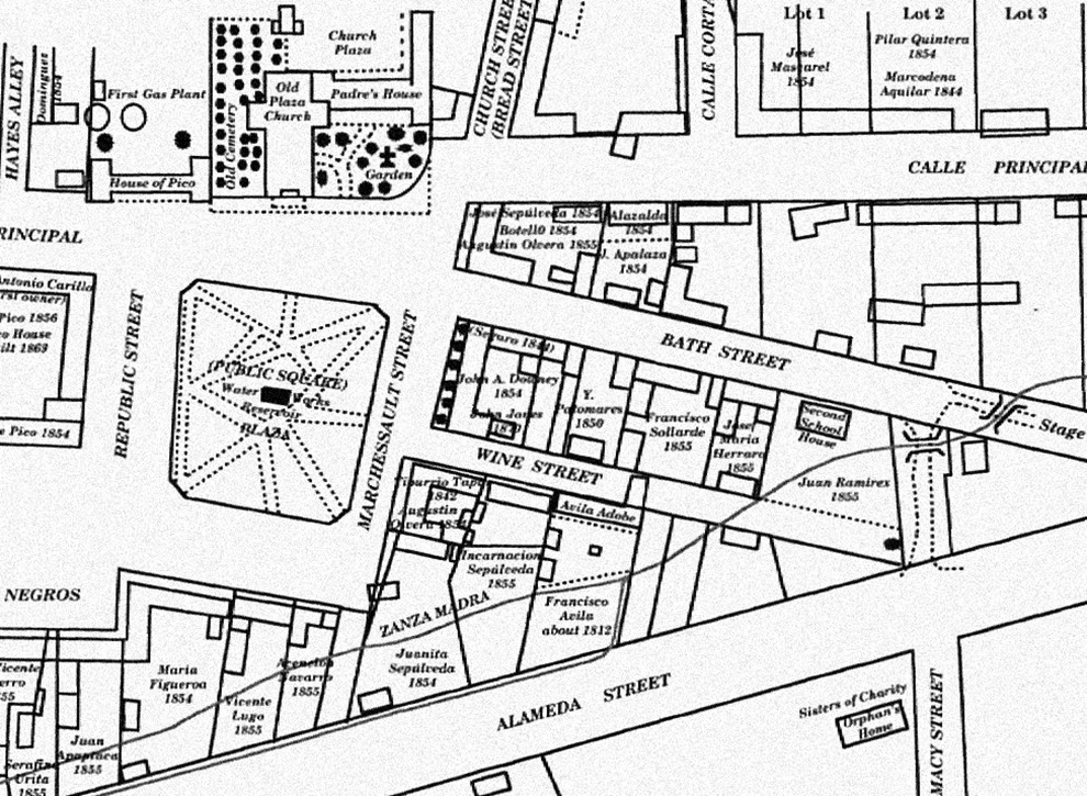 |
|
| (1873)* – Early map showing the Plaza area, including the center of town with its early buildings and the Zanja Madre, Los Angeles' original water aqueduct and lifeline. The Sisters of Charity building is seen at lower right on the southeast corner of Alameda and Macy Street. |
Historical Notes The map also shows the streets in use and the early owners of many of the properties. The layout of the plaza itself, however, is shown as it appeared before the change in landscaping in the prior two years before it became rounded. |
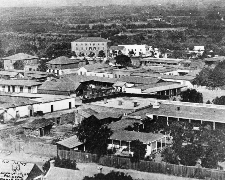 |
|
| (1875)* – View looking northeast over the Los Angeles Plaza area and Wine Street (later Olvera Street) showing the 3-story brick building of the Sisters of Charity on the southeast corner of Alameda and Macy Streets. |
Historical Notes In the foreground of the above photo is the courtyard of Nuestra Senora la Reina de Los Angeles, showing the padres' kitchen, bishop and padres' quarters, parochial school and courtyard planted to citrus orchard. To the left of this, a low white adobe, is the bakery of Pierre Domegue and his Indian wife, who baked sourdough French bread. Behind this on the next block are two square buildings, the Bath Street (later Olvera Street) Public School. In the rear is a three-story building at Alameda and Macy Streets, the Los Angeles Charitable Institute run by the Sisters of Charity. Just behind the bakery is the Pelanconi Winery, later La Golondrina Restaurant. Also shown, behind the church facilities, is the adobe residence of Mr. and Mrs. John Jones, parents of Mrs. Lankershim. |
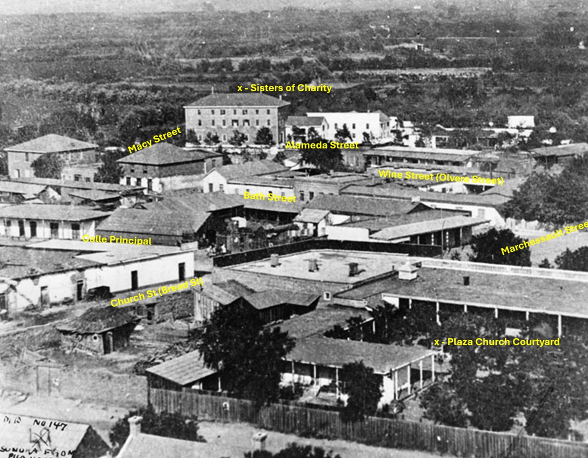 |
|
| (1875)* – View looking northeast over the Los Angeles Plaza area and Wine Street (later renamed Olvera Street), showing the 3-story brick building of the Sisters of Charity on the southeast corner of Alameda and Macy Streets. Today, the site is adjacent to Union Station and the Mozaic at Union Station Apartments. |
Historical Notes Following the Sisters' departure, the original property underwent dramatic changes. In the early 20th century, Los Angeles embarked on major redevelopment projects, and the orphanage site became part of the land cleared for the construction of Union Station, completed in 1939. Although the original orphanage buildings were lost to time, the historical significance of the location remains. Today, the site is adjacent to Union Station and Mozaic at Union Station Apartments, standing as a quiet reminder of one of Los Angeles' earliest and most important charitable institutions. |
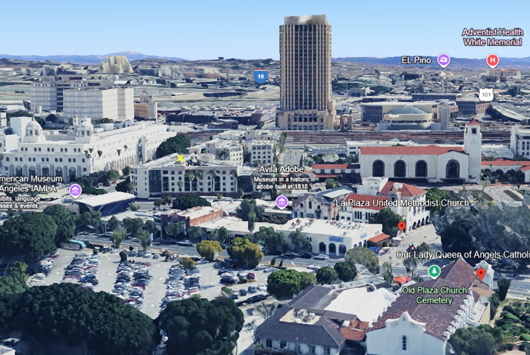 |
|
| (2023)* – Google Earth view looking toward the southeast corner of Alameda Street and Cesar Chavez Avenue (originally named Macy Street), where an "X" marks the spot where the main 3-story Sisters of Charity building once stood. Today, the site is occupied by the Mozaic at Union Station Apartments. |
Then and Now
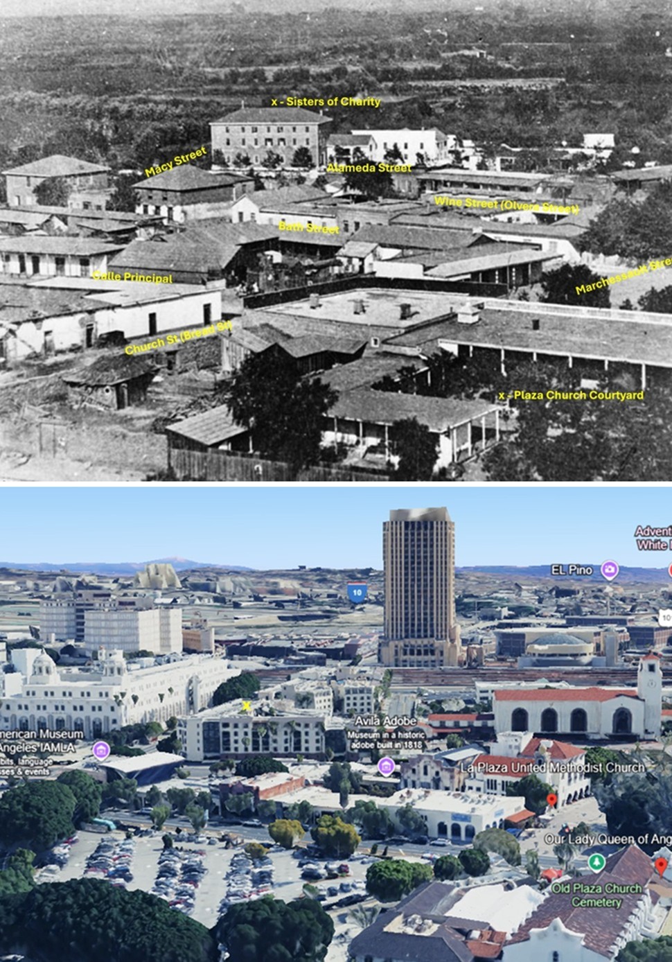 |
|
| (1875 vs. 2023)* – A ‘Then and Now’ comparison showing the 3-story Sisters of Charity building at the southeast corner of Alameda Street and Macy Street (now Cesar Chavez Avenue), where the Mozaic at Union Station Apartments stand today, directly across from the Terminal Annex Post Office Building. Photo comparison by Jack Feldman. |
* * * * * |
Antonio Mario Lugo Adobe
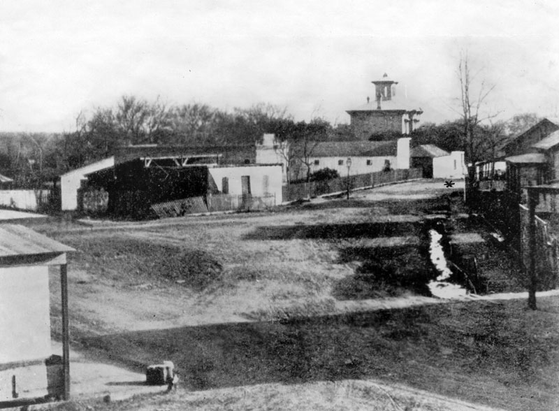 |
|
| (ca. 1875)^ - Early view of the Plaza surroundings, including Antonio Maria Lugo adobe, built in 1820, and located at San Pedro near 2nd Street. The Lugo adobe is indicated by a star (middle right), and the large towered building seen in the center distance is the Wallace Woodworth residence. |
Historical Notes Antonio Maria Lugo (1775-1860) was born at the San Antonio de Padua Mission near Monterey. A Corporal in the Spanish army, he received his discharge after seventeen years and was granted 29,514 acres of land as a reward for his faithful service to the King of Spain and the military. He named this tract of land Rancho San Antonio, after his birthplace. Lugo maintained a beautiful adobe home in the pueblo, located in the exclusive Plaza and across from the church. In 1816 Lugo was appointed Alcalde (Mayor) of Spanish Colonial Los Angeles, and served until 1819. Don Antonio Maria Lugo, or "El Viejo Lugo" - an endearing title bestowed upon him, gradually added vast properties, and was the owner of much of what is now the city of Los Angeles; it was said he could ride from San Diego to Sonoma, a distance of nearly 700 miles, without once leaving his own land. After Don Antonio's death in 1860, the rancho was divided among his children: José María, José del Carmen, Vicente, Jesus, and Merced. |
.jpg) |
|
| (ca. 1885)* - View showing the home of Don Antonio Mario Lugo located on San Pedro Street, near Second Street, Los Angeles. |
Historical Notes The Don Antonio Mario Lugo adobe was built in 1820. The single-story house has extended roof supported by beams at about every ten feet. A wooden fence encloses the perimeter to the right of the house. Trees are visible in the background. Picture file card reads: "1st house with wood floor?" |
* * * * * |
Horticultural Hill & North Edge of Bunker Hill
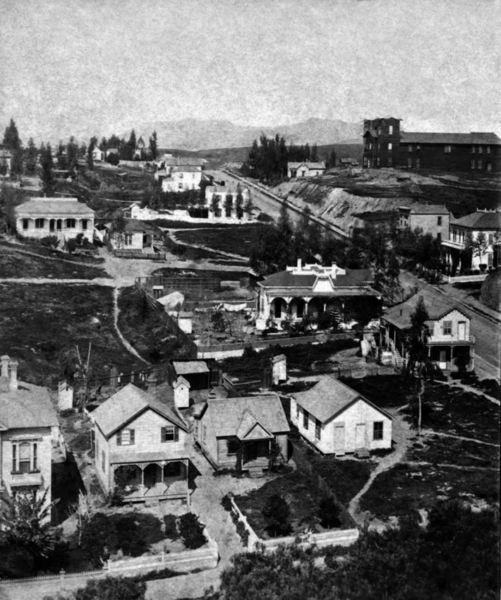 |
|
| (ca. 1875)^ - View is toward the N/W on Temple Street looking across Horticultural Hill. Olive Street is in the foreground. The Horticultural Hill on Temple Street is at upper right. The Hollywood Hills are faintly seen in the background. One can make out the tallest peak, Hollywood Peak, near where the Griffith Observatory stands today. |
Historical Notes The Horticultural Pavilion is the largest and tallest structure appearing in the upper right of the photo. A grand staircase would later be built from the pavilion down to Temple St. Directly across the pavilion on Temple St. was the first Los Angeles home of Sarah Bixby Smith ("Adobe Days", 1931). In her memoir of early Los Angeles she describes the Horticultural Pavilion as "a barn-like, wooden building" which was the venue for "county fairs, conventions and operas". In 1880, President and Mrs. Hayes visited Los Angeles, the first President to visit California. After speeches from a grandstand set up in front of the Baker Block, the guests adjourned to the St Elmo Hotel for tea. In the evening a public reception and formal dinner were held for the First Couple in the Horticultural Pavilion. The Horticultural Pavilion was lost to fire a few years later. Its function was replaced by Hazard's Pavilion (1887) at 5th and Olive streets. Also in the photo is an early home of J.W. Gillette, who built Angels Flight for Col. Eddy. It's near the center of the photo, with a walled backyard. It faces on Temple. |
Then and Now
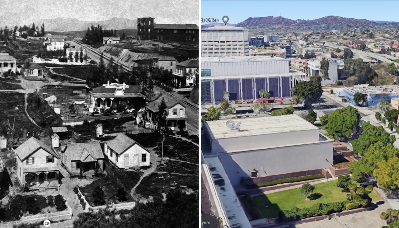 |
|
| (1875 vs 2022)* – View looking NW showing Temple Street running diagonally on the right with the Hollywood Hills in the Background. In the early photo, Olive Street is seen at bottom and Horticultural Hall is seen at top of the hill (aka Horticultural Hill). Note how much the hill as been chopped down over the years. Photo comparison by Jack Feldman. |
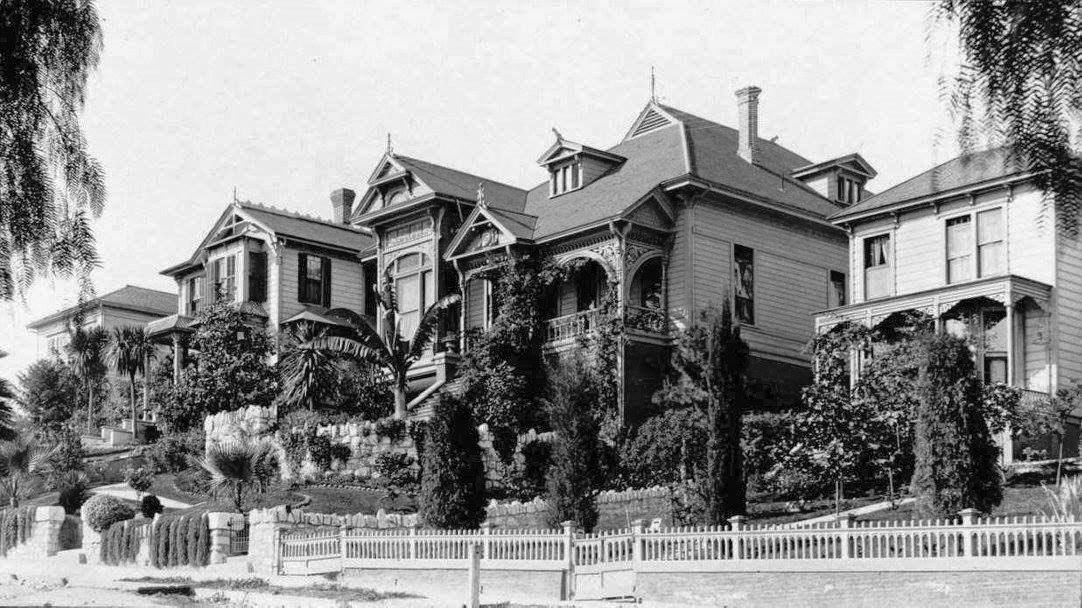 |
|
| (ca. 1895)* – View of the 200 block of South Olive Street in downtown Los Angeles showing beautiful Victorian homes. |
Historical Notes Similar homes can be seen today on Carroll Avenue in Angelino Heights, just outside of downtown. |
* * * * * |
Macy Street Bridge (LA's 1st Bridge)
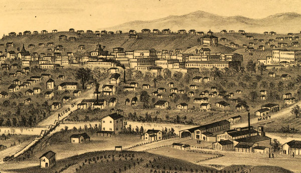 |
|
| (1877)* - Detail of a drawing by E.S. Glover of Los Angeles, showing the city's first bridge on the right and the later Aliso Street bridge on the left. The view looks west toward downtown Los Angeles from Boyle Heights. Los Angeles High School can be seen in the upper right on top of Poundcake Hill. |
Historical Notes A furniture company named Perry and Woodworth built Los Angeles' first permanent bridge, a covered bridge, in 1870. Its construction was considered a major civic achievement; people came from as far away as San Diego to witness the bridge's opening. A covered bridge reminiscent of those in New England, the wooden span carried Old Aliso Road, a segment of El Camino Real later known as Macy Street and now named Cesar Chavez Avenue, across the Los Angeles River. Where wagons once forded the tame summer river -- or simply turned around when winter storms transformed the stream into a torrent -- a bridge now connected the growing city of Los Angeles to the agricultural land on the river's east bank.* |
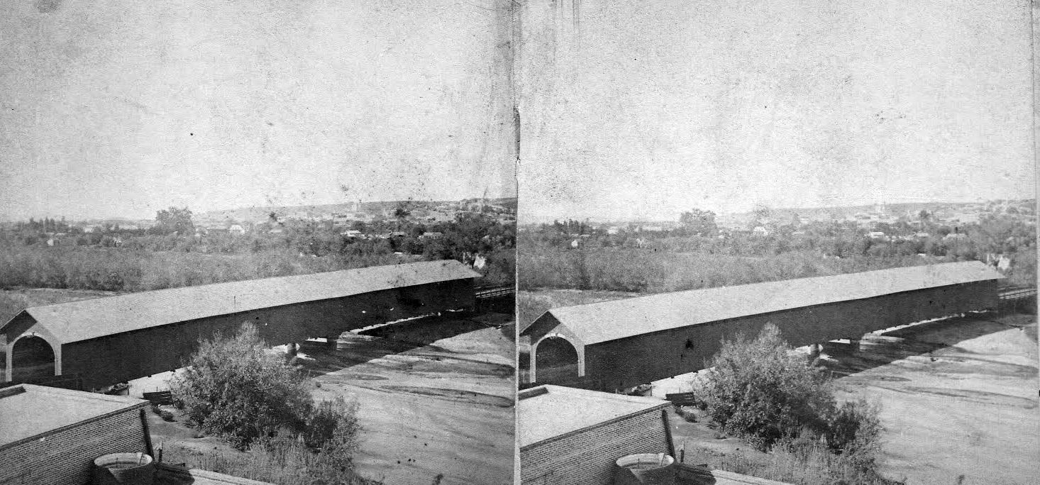 |
|
| (ca. 1870s)^ - Stereographic photo of the covered bridge over Old Aliso Road (Macy Street). |
Historical Notes Without this lengthy span, it would not have been possible to have had the subsequent eastward expansion of the town, which was then embarking on it first significant growth spurt, which began shortly after the conclusion of the Civil War. In 1873, local power brokers created the subdivision of East Los Angeles, later renamed Lincoln Heights, and this was followed in 1875 by the trio of William H. Workman, Isaias W. Hellman and John Lazzarovich's development of Boyle Heights.^ L.A.'s first bridge was resilient, withstanding several severe floods in the 1880s while others failed. But eventually, time wore away at the wooden structure, and by 1895 it was in poor condition. The city engineer recommended replacing it with one of a more modern design, and in July 1904 the bridge finally came down. "One of the old landmarks of the city," the August 1, 1904 Los Angeles Times reported, "has disappeared during the past week, and the Macy-street bridge...is a thing of the past. It has been pulled down to make way for a splendid modern structure which will accommodate traffic for years." * Click HERE to see the 2nd Macy Street Bridge. |
* * * * * |
San Fernando Mission
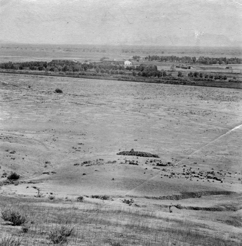 |
|
| (1873)^ - This is the first known photograph of the San Fernando Valley as seen in 1873. View is looking to the south, showing San Fernando Rey de España Mission in the center of the photograph. Apart from the mission, the vast land appears to be completely deserted. Mission San Fernando Rey de España is located at 15151 San Fernando Mission Boulevard. |
Historical Notes In 1821, after the successful Mexican War of Independence from Spain, the Mission San Fernando became part of Alta California, Mexico. In 1834, the Mexican government began redistributing the mission lands. In 1846, the Mexican land grant for Rancho Ex-Mission San Fernando was issued by Governor Pío Pico. It was bounded on the north by Rancho San Francisco and the Santa Susana Mountains, on the west by the Simi Hills, on the east by Rancho Tujunga, and on the south by the Montañas de Portesuelo (Santa Monica Mountains).*^ Click HERE to see more in Early Views of the San Fernando Mission. |
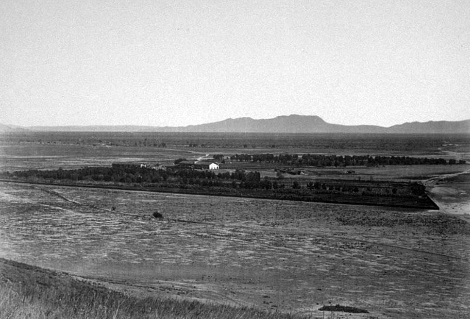 |
|
| (ca. 1875)#^ – Panoramic view of the San Fernando Mission looking south across a largely unimproved San Fernando Valley. In the distance are the Hollywood Hills with Cahuenga Pass (low point on the horizon in the upper-right) and the back of Mount Lee (highest peak and ridgeline). #^* |
Historical Notes Rancho Ex-Mission San Fernando was a 116,858-acre Mexican land grant in 1846 by Governor Pío Pico to Eulogio de Celis. The grant derives its name from the secularized Mission San Fernando Rey de España, but was called ex-Mission because of a division made of the lands held in the name of the Mission — the church retaining the grounds immediately around, and all of the lands outside of this were called ex-Mission lands. The grant encompassed most of the present day San Fernando Valley.*^ |
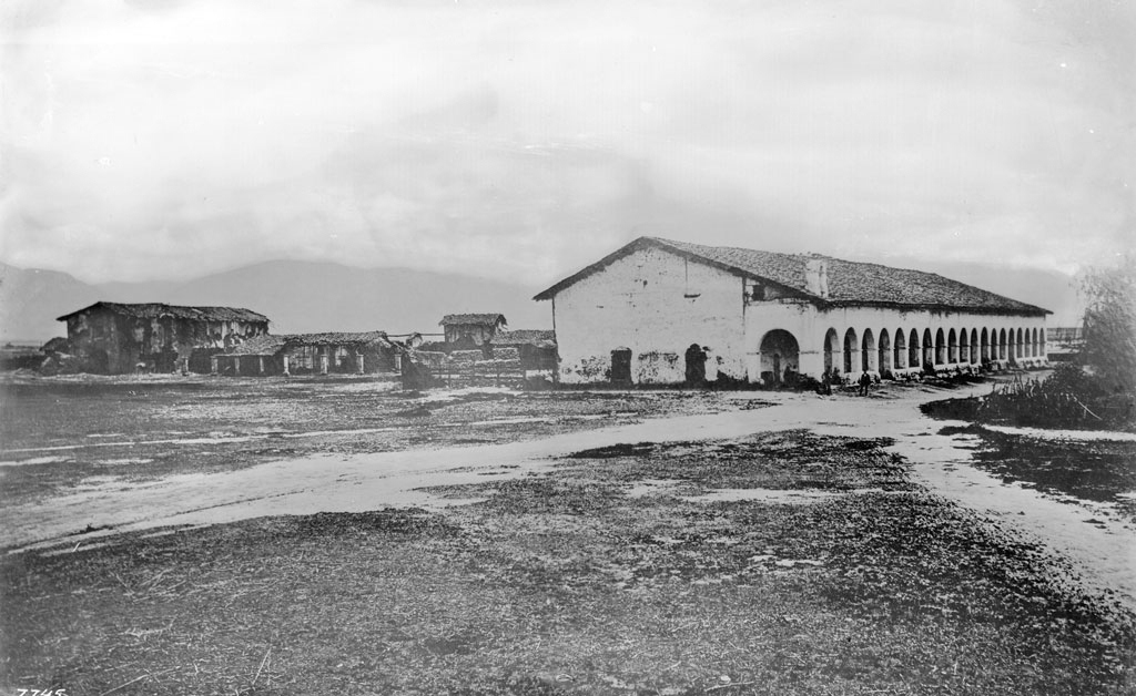 |
|
| (ca. 1870)^^ - Exterior view of the Mission San Fernando, ca.1870. Two dirt paths enter in from the foreground, intersecting at the adobe cloister of the mission, which stands to the right of center. A collection of archways holds the eaves of the terracotta-tiled roof up over the cloister's patio. More adobe buildings can be seen to the left, with two-story adobe building standing to the left of an older cloister whose roof has collapsed. |
Historical Notes In 1874, after the death of Eulogio de Celis, the family sold their northern half of Rancho Ex-Mission San Fernando to northern Californians, California State Senator Charles Maclay and his partners George K. Porter, a San Francisco shoe manufacturer, and his cousin Benjamin F. Porter. The Porters’ land was west of present day Sepulveda Boulevard including most of Chatsworth, and the Maclay land was east of Sepulveda Boulevard. Roscoe Boulevard was the border on the south, with a syndicate led by Isaac Lankershim acquiring the southern half of the Valley.*^ |
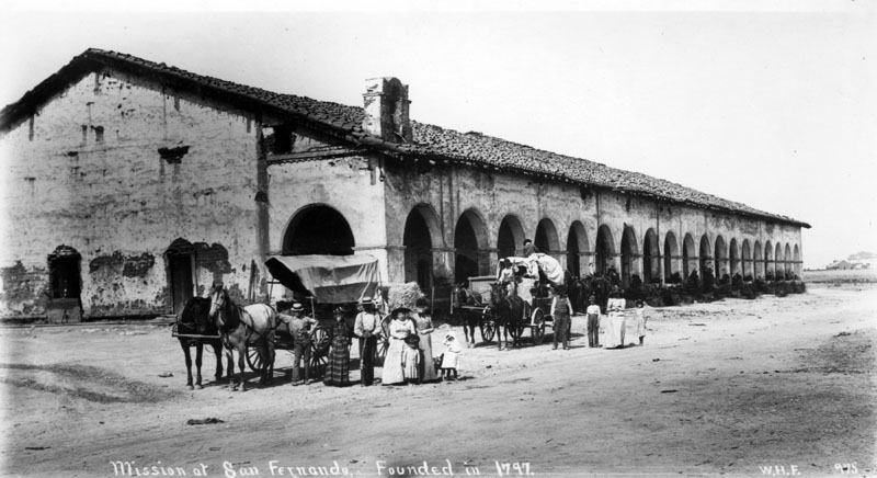 |
|
| (1800s)^ - View of the Convento Building, also known as the "Long Building". Two families stand next to their horse-drawn carriages, which have stopped along the road that would eventually become "El Camino Real". |
Click HERE to see more in Early Views of the San Fernando Valley |
* * * * * |
Catalina Island
 |
|
| (1887)^^ - View of Avalon Bay, Catalina Island, showing a Ferndale steamboat and a Ruby schooner. The schooner is visible on the water at center, a small flatboat with two people visible in front of it. Farther to the left of it, a second sailboat can be seen. The steamer is pictured flying an American flag off of its stern at right. A mountain ridge and large hill are pictured in the background. |
Historical Notes The first European to set foot on Santa Catalina Island was the Portuguese explorer Juan Rodríguez Cabrillo, who sailed in the name of the Spanish crown. On October 7, 1542, he claimed the island for Spain and christened it San Salvador after his ship. Over half a century later, another Spanish explorer, Sebastián Vizcaíno, rediscovered the island on the eve of Saint Catherine's day (November 24) in 1602. Vizcaino renamed the island in the saint's honor.*^ |
 |
|
| (ca. 1888)#**^ - View of a steamer at the dock in Avalon Bay and the Hotel Metropole in Avalon, Santa Catalina (aka Catalina Island or just Catalina). |
Historical Notes The first owner to try to develop Avalon into a resort destination was George Shatto, a real estate speculator from Grand Rapids, Michigan. Shatto purchased the island for $200,000 from the Lick estate at the height of the real estate boom in Southern California in 1887. Shatto created the settlement that would become Avalon, and can be credited with building the town's first hotel, the original Hotel Metropole, and pier. His sister-in-law Etta Whitney came up with the name Avalon, which was taken from Alfred, Lord Tennyson's poem "Idylls of the King," about the legend of King Arthur.*^ |
 |
|
| (ca. 1890s)^^ - View showing Avalon Bay from the hillside behind the Hotel Metropole (center). A steamboat is seen in the middle of the bay just beyond the hotel. A Multitude of house-tents are seen throughout and Sugarloaf Point is stands on the left. |
Historical Notes To expand Avalon's tourist base, Shatto used steamships he leased from the Bannings to ferry tourists to and from the mainland. Some island tourists arrived to purchase lots in Avalon, which Shatto auctioned off for $150 to $2,000 depending on location and size. Those who purchased one were then free to set up tents or build summer cottages. However, Shatto racked up some hefty bills and defaulted on his mortgage payments only after a few years and the island went back to the Lick estate.^^ |
 |
|
| (ca. 1890s)#^*^ - Panoramic view looking southeast showing Hotel Metropole and steamer Hermosa. The large boat is docked at the pier with smaller boats in the water. Tents are visible close to the beach as well as buildings. Women are wearing high collared long sleeved dresses and gloves. On the right can be seen a windmill and clothes hanging on a clothesline. |
Historical Notes The sons of Phineas Banning bought the island in 1891 from the estate of James Lick and established the Santa Catalina Island Company to develop it as a resort. They had a variety of reasons for doing this. They wanted Catalina's rock to build a breakwater at Wilmington for their shipping company. They had also just built a luxurious new boat, the Hermosa, to bring tourists to the Island. If tourism failed, this investment was at risk. By owning Catalina, they would not only get their rock, but also money from tourists for their passage as well as everything on the Island.*^ |
 |
|
| (1891)#^*^ – Panoramic view of Avalon Bay on Santa Catalina Island. The rock formation called Sugarloaf Point is at upper-right. The steamship S.S. Hermosa makes its way out toward the ocean away from a pier which is located near where the Hotel Metropole stands. House-tents can be seen all along the beach. At right stands a large Victorian-style home (Holly Hill House) with unobstructed views of the bay. The house still exists today and is Avalon's oldest remaining structure. |
Click HERE to see more in Early Views of Catalina |
* * * * * |
More Historical Early Views
Newest Additions
Early LA Buildings and City Views
History of Water and Electricity in Los Angeles
* * * * * |
References and Credits
* DWP - LA Public Library Image Archive
^ LA Public Library Image Archive
*# Publications of the Historical Society of Southern California, Volume 9: Eternity Street
#* OUTPOST – Preserving Historical Data by W. S. Broke
#^ Huntington Digital Library Archive
+^ Old Los Angeles and Environs blogspot
*+ The Jews of Los Angeles: Urban Pioneers
++ Vigilantism in Los Angeles (1853 - 1874)
^**UCLA-DWP Library Collection: Map of the City of Los Angeles as it Appeared in 1850
***Los Angeles Historic - Cultural Monuments Listing
*^*California Historical Landmarks Listing (Los Angeles)
*^#Public Art in LA: Campo Santo
^^#CSULB - A Visit to Old LA: Main Street
*##Metro.net - Los Angeles Transit History
^##California State Library Image Archive
**#The Cable-Car-Guy.com: The Los Angeles Railway
*#*KCET - Inventing LA: Port of Los Angeles; A Brief History of LA Bridges; LA's First Streetcars
**^History Matters: Calle de los Negros, 1880s
^^*LA Fire Department Historical Archive
^*#Noirish Los Angeles - forum.skyscraperpage.com
^#^Historic Hotels of Los Angeles and Hollywood (USC - California Historic Society): Bella Union Hotel; Lafayette Hotel
#^*Flickr.com: Michael Ryerson
#++Facebook.com: Garden of Allah Novels, Martin Turnbull
*^^Los Angeles Magazine: Zanja Madre 1868
*^*^Wilmington Historic Society
**^^Boyle Heights History Timeline
*#^^LAPL-El Pueblo de Los Angeles Historical Monument Photo Archive
*^^#Boyle Heights History Blog
^#**Santa Monica History Museum
^#*^ElPueblo.lacity.org: Plaza Map
^##^El Pueblo de Los Angeles Historical Monuments Listing
^*^*KCET - El Aliso: Ancient Sycamore Was Silent Witness to Four Centuries of L.A. History
#**^LA County Library Image Archive
#*#^LAPL-El Pueblo de Los Angeles Historical Monument Photo Archive
#^#^Chinese Los Angeles in 1870-1871 - Scott Zesch
#^*^Calisphere: University of California Image Archive
#^#*Picture Gallery of Los Angeles History
*^ Wikipedia: Arcadia Bandini de Stearns Baker; Bunker Hill; Prudent Beaudry; Jonathan Temple; Los Angeles High School; Joseph Widney; Pershing Square; Port of Los Angeles; Belmont High School; Hollenbeck Park; Ducommun; Isaias W. Hellman; Abel Stearns; Sawtelle Veterans Home; Arcade Station; Alhambra; Fort Moore; History of Santa Monica; History of Los Angeles; Burbank; Los Angeles and Independence Railroad; Phineas Banning; History of Los Angeles Population Growth; Ozro W. Childs; The Church of Our Lady the Queen of Angels; Fort Moore; Santa Catalina Island; San Fernando Valley; Chinese Massacre of 1871; The Church of Our Lady the Queen of Angels
< Back