Early Views of Hollywood (1920 +)
Historical Photos of Early Hollywood |
 |
|
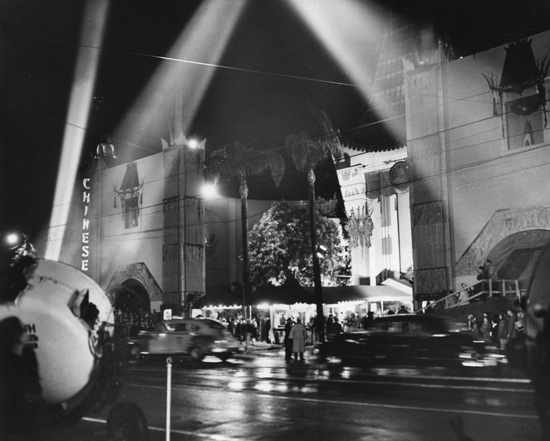
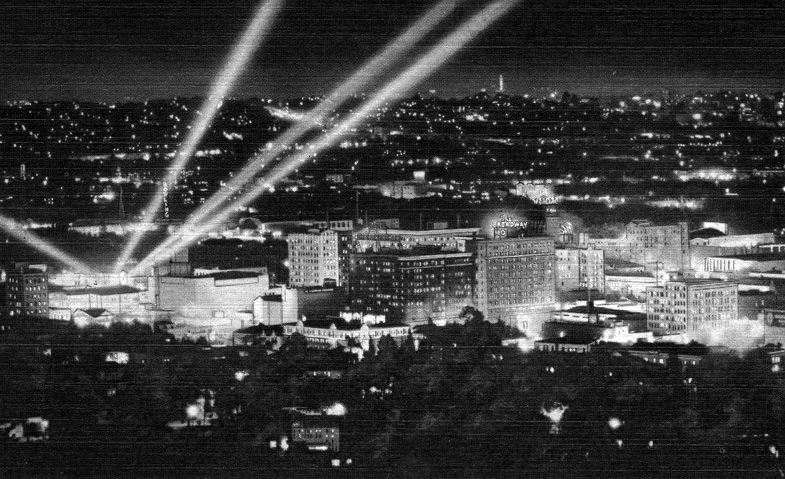
| (1940s)* - Spotlights draw attention to a film premiere taking place at Grauman's Chinese Theatre, located at 6925 Hollywood Boulevard. |
Historical Notes During the 1940s Grauman’s Chinese Theatre was the most famous movie palace in Hollywood and the site of many major premieres. Powerful spotlights swept the sky to announce the arrival of film stars and to draw crowds from blocks away. Premieres were major public events and thousands of people often gathered to watch the celebrities step out of their cars and walk through the forecourt. This period reflects the height of the studio system when movie companies used these highly staged premiere nights to promote their stars and new films. The bright lights, large crowds, and ornate theatre design helped create the image of Hollywood glamour that was known around the world. Photos from these nights show how Hollywood Boulevard could feel like a celebration every time a new picture opened. |
 |
|
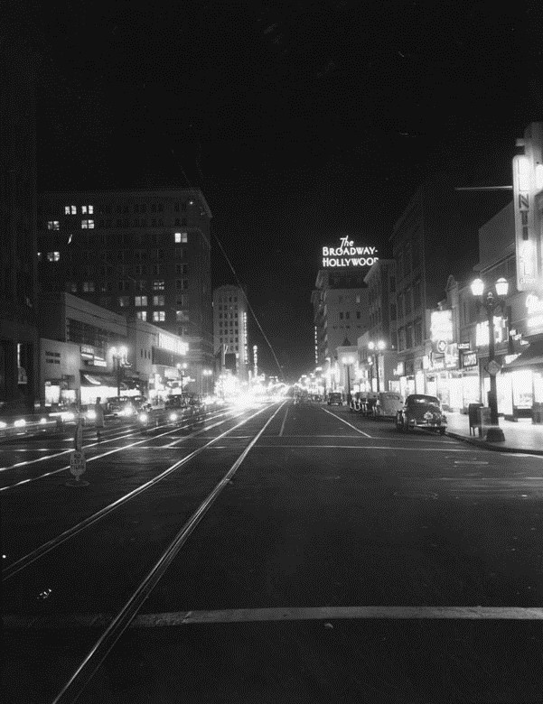
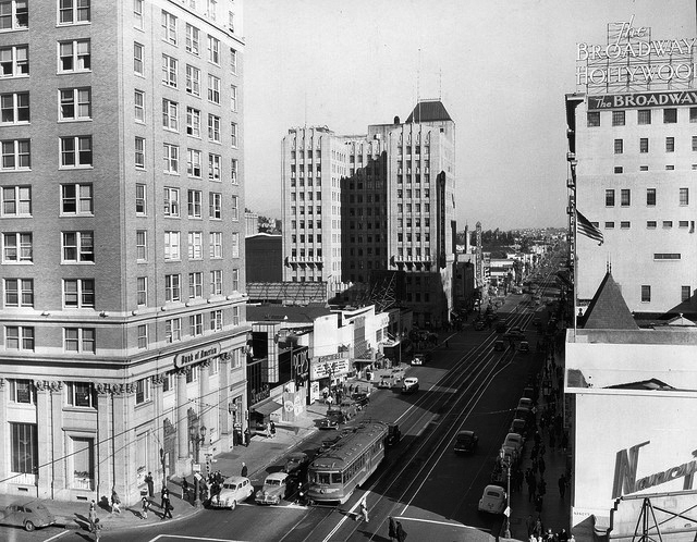
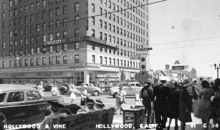
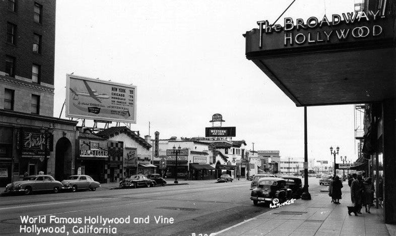
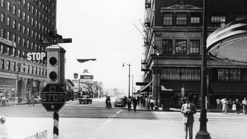
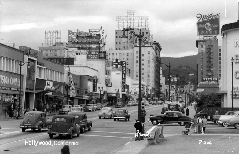
| (1940s)* - Looking east down Hollywood Boulevard towards Vine Street and the Broadway-Hollywood Building.. |
Historical Notes This view from the 1940s shows Hollywood Boulevard when it was an active commercial street filled with theaters, shops, and steady automobile traffic. In the distance stands the Broadway Hollywood Building which served as a major landmark at the corner of Hollywood and Vine. The intersection was already becoming known for radio broadcasting studios, nightlife, and the growing entertainment industry around it. The photo captures a moment when Hollywood still blended everyday business with the excitement of the entertainment world. Streetcars had recently been removed from this stretch of the boulevard, but neon signs and busy sidewalks continued to give the area a lively feeling. This view helps show how Hollywood’s identity was shaped by both commerce and entertainment long before it became a major tourist destination. |
* * * * * |
Santa Claus Lane
 |
|
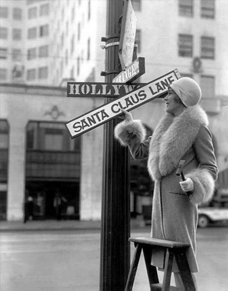
| (ca. 1930s)* - Mary Pickford in a publicity shot changing sign in preparation for the Santa Claus Lane parade. |
Historical Notes Beginning in 1928 Hollywood merchants and the Hollywood Chamber of Commerce turned a one mile stretch of Hollywood Boulevard into what they called Santa Claus Lane in an effort to draw more shoppers during the holiday season. They planted live fir trees brought in from the mountains, strung them with lights, and created a daily parade that featured Santa Claus riding along the boulevard with a different film star. The first parade was a simple event with Santa and actress Jeanette Loff, but it quickly became a local tradition. Publicity photos of major stars like Mary Pickford changing the street signs helped link Santa Claus Lane to Hollywood glamour and encouraged visitors to see Christmas on Hollywood Boulevard as something special. |
 |
|
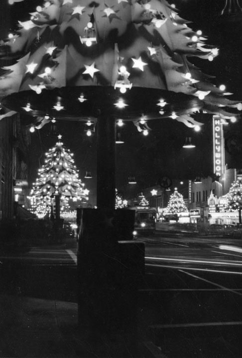
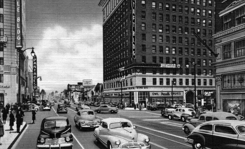
| (ca. 1940s)* - View looking west on a holiday-infused Hollywood Boulevard from Argyle Ave. The Pantages Theatre is in the foreground on the right and the Taft Building in the distance on the left. |
Historical Notes By the early 1940s Santa Claus Lane had grown from a small merchants’ promotion into one of the major holiday attractions in Los Angeles. Light poles along the boulevard were wrapped to look like glowing Christmas trees and illuminated stars hung over the street. The parade grew as well. In 1931 Santa traded his reindeer drawn carriage for a truck pulled float, which made it easier to move through the expanding crowds. American Legion Post 43 added a color guard, a drum line, and a bugle corps, giving the event more pageantry. Views from Argyle Avenue show how the decorations tied the theater district together into a long, brightly lit holiday corridor. |
 |
|
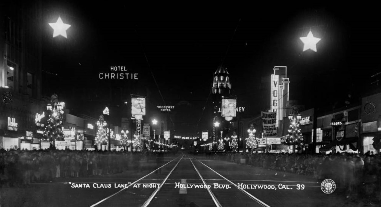
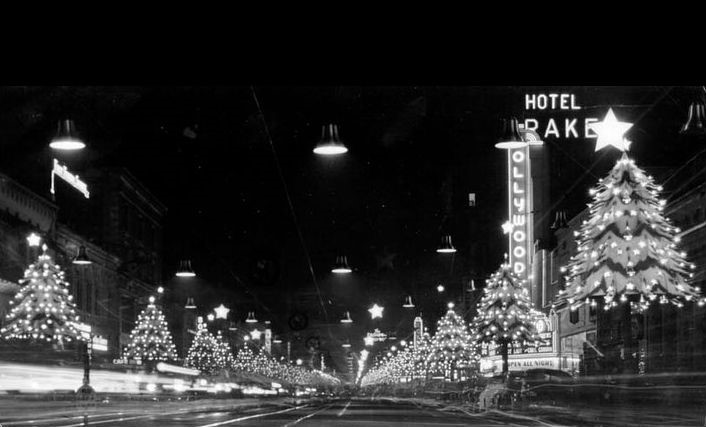
| (1937)* – Postcard view looking west on Hollywood Boulevard showing "Santa Claus Lane". Crowds of people line the street as they await for the parade to begin. Electric Christmas tree and star decorations are seen along the boulevard. Also seen are the: Vogue Theatre, Egyptian Theatre, Hotel Christie, Roosevelt Hotel, and First National Bank Building (with illuminated tower) in the distance. An electric sign hanging over the boulevard reads "Navy Blue-Gold" and movie banners read "Eddie Cantor 'Ali Baba Goes to Town,' " and "Jungle Princess Dorothy Lamour and Ray Milland." |
Historical Notes This 1937 postcard captures Santa Claus Lane at the moment when the parade and the holiday promotion had become firmly established. Electric Christmas trees and stars line the center of the boulevard and thousands gather along the sidewalks. Well known buildings such as the Vogue Theatre, the Egyptian Theatre, the Hotel Christie, the Roosevelt Hotel, and the tower of the First National Bank help define the scene. Movie studios used the holiday crowds to promote their films, which is why banners for pictures such as Eddie Cantor in Ali Baba Goes to Town and Jungle Princess with Dorothy Lamour and Ray Milland appear in the postcard. The image shows how Hollywood blended Christmas celebration with studio promotion to create a unique holiday atmosphere. |
 |
|
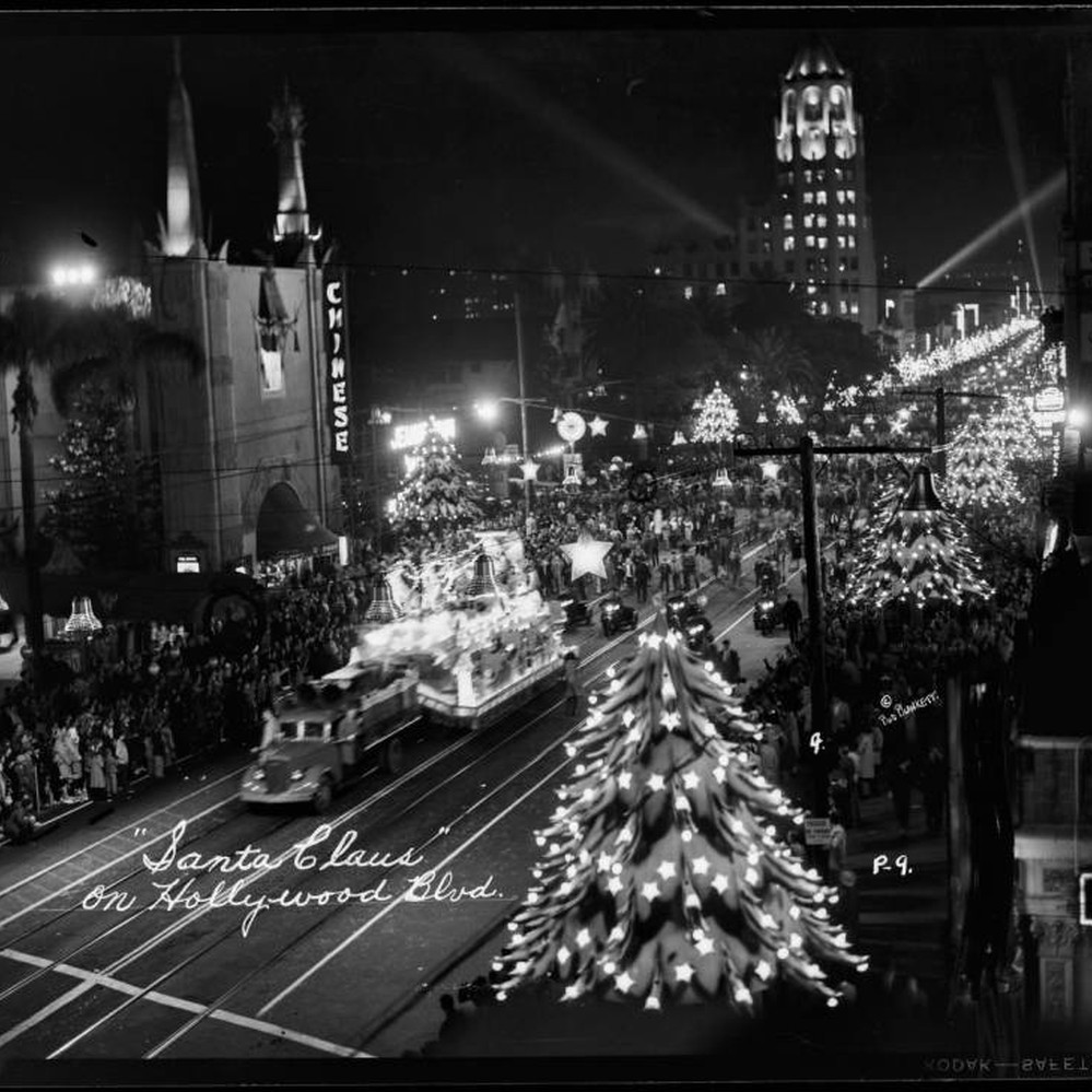
| (ca. 1941)* - Image of a truck pulling a Santa Claus float on Hollywood Boulevard at night in Hollywood, California, with electric Christmas trees and stars decorating the boulevard and Grauman's Chinese Theatre and the First National Bank Building (with tower) in the background. Photo by Bob Plunkett. |
Historical Notes By 1941 the parade had taken on the form most people remember. Santa rode on a brightly lit float pulled by a truck and was followed by other floats, marching bands, and community groups. Night scenes along the boulevard show rows of electric Christmas trees and stars stretching into the distance, making the whole street feel like a stage set. American Legion Post 43 and local organizations helped turn the parade into a major civic event. These images also represent the last parades before the country entered World War II, when materials and public gatherings were restricted and the parade was paused for several years. |
 |
|
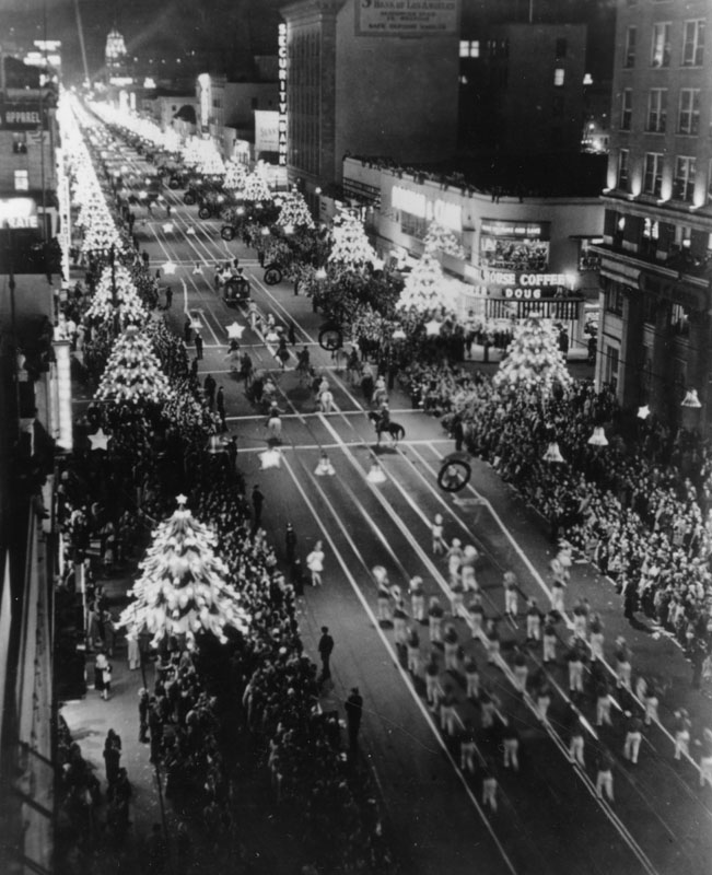
| (1945)* - A view looking down upon Hollywood Blvd. from the east on the eve of the annual Santa Claus Lane Parade (now called the Hollywood Christmas Parade). Christmas decorations can be seen on the festively lit boulevard. |
Historical Notes This 1945 photograph shows how strongly Los Angeles welcomed the return of the Santa Claus Lane Parade after it had been suspended from 1942 through 1944 during World War II. When the parade came back, the crowds were larger than ever. Decorations lit up the boulevard and people celebrated the return of peace and normal life. In 1946 Gene Autry rode his horse in the parade. When he heard children along the boulevard call out Here comes Santa Claus he was inspired to write the song of the same name with Oakley Haldeman. The song became a hit and helped spread the name Santa Claus Lane far beyond Hollywood. |
 |
|
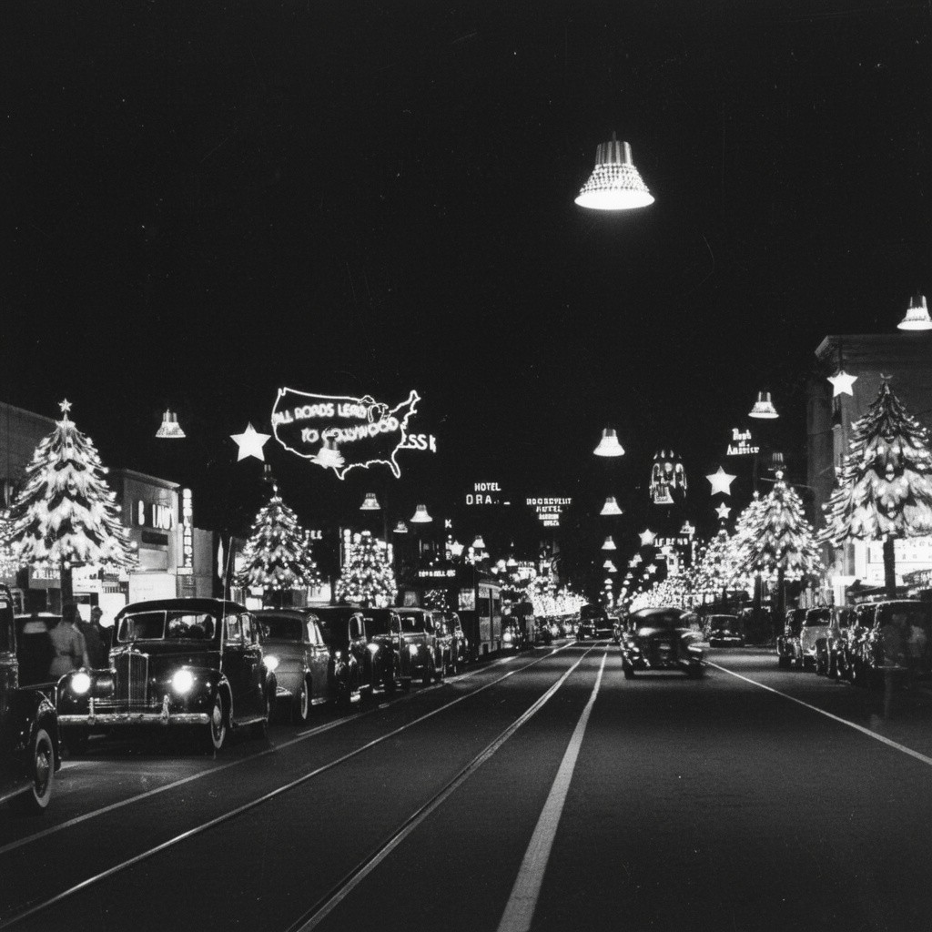
| (1945)* - Cars driving along the street in Hollywood called Santa Claus Lane at Christmas time. |
Historical Notes This scene from 1945 shows how Hollywood Boulevard looked during the holiday season even when the parade was not taking place. The decorated trees, glowing stars, and Christmas displays stayed up throughout December, turning a regular evening drive into part of the celebration. As the years went on, the parade grew even more. Through the 1950s, 1960s, and 1970s it added floats, animals, marching bands, and a growing list of celebrities. In 1978 the event was renamed the Hollywood Christmas Parade to attract wider attention and KTLA began broadcasting it with the help of Johnny Grant. What began as a merchants’ promotion on a single mile of Santa Claus Lane became a well known holiday tradition across the country. |
 |
|
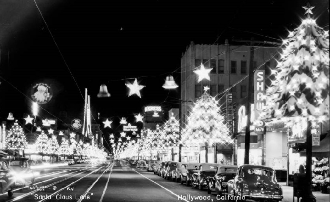
| (1946)* - Postcard view looking east showing a well-lit Hollywood Boulevard during the Holiday Season. Card reads “Santa Claus Lane”. The Broadway Building and Kress building are in the distance, and Shaw's can be seen at right. |
Historical Notes This 1946 postcard shows Hollywood Boulevard during the first full holiday season after World War II. Stores like The Broadway and Kress relied on the Christmas season, and the Santa Claus Lane decorations helped bring in large numbers of shoppers. Businesses along the boulevard decorated their storefronts and stayed open late to take advantage of the crowds. Smaller shops such as Shaw’s also benefited from the increased foot traffic. Around this time Gene Autry’s new song Here Comes Santa Claus became popular, linking the image of a brightly lit Hollywood Boulevard with American holiday music and culture. |
 |
|
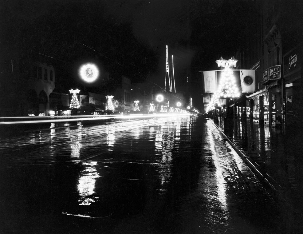
| (ca. 1940s)* - View showing Santa Claus Lane in Hollywood at night. The road is wet, and the images of surrounding buildings are reflected in the glossy surface. Shops can be seen lining both sides of the road, and Christmas tree-shaped decorations hang on light posts. A streetlight can be seen hanging over the street at center. Legible signs include, from left: "Tailors", "Platt Music Co.", and "Stoner's Shoes". |
Historical Notes This night view from the 1940s shows a quieter but equally memorable side of Santa Claus Lane. The wet pavement reflects the glow of shops and Christmas decorations, creating a vivid mirror effect. Stores such as tailors, Platt Music Company, and Stoner’s Shoes depended on the holiday crowds, and the decorations helped draw people into the shopping district even when there was no parade. For many families the combination of glowing trees, bright signs, streetcars, and store windows turned Hollywood Boulevard into a place of holiday memory and tradition, blending everyday commerce with the magic of Christmas. |
* * * * * |
Hollywood and Highland
 |
|
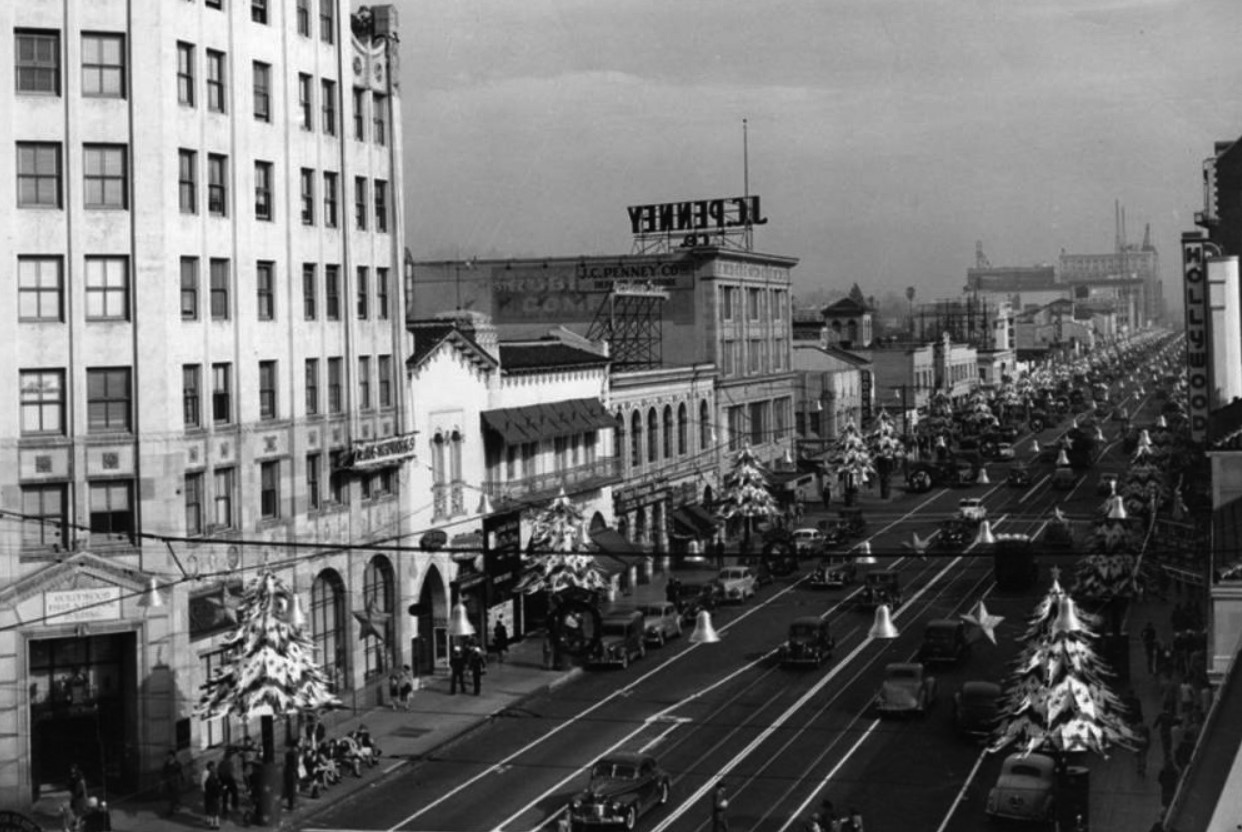
| (ca. 1940)* - Looking east on Hollywood Blvd from Highland Ave during the holiday season. Christmas tree decorations can be seen on the light standards lining the sidewalks and bell and star decorations hang across the street at regular intervals on this portion of Hollywood Blvd, which is known as Santa Claus Lane. The Hollywood First National Bank, First Federal Savings of Hollywood, and J.C. Penney Co. are visible on the left. The 1913-built Hollywood Theatre can be seen on the right. Pacific Electric streetcar tracks run in both directions down the center of the boulevard. |
Historical Notes During the late 1930s and early 1940s, Hollywood Boulevard was promoted as Santa Claus Lane, a holiday attraction created by the Hollywood Chamber of Commerce to draw shoppers during the Christmas season. The decorations seen in the photo, including stars, bells, and small Christmas trees on the streetlights, were part of this annual celebration. On the left stands the Hollywood First National Bank Building, one of the area’s earliest high-rise landmarks. Nearby were First Federal Savings of Hollywood and the J. C. Penney store, reflecting the boulevard’s growth as a major shopping district. On the right is the Hollywood Theatre, built in 1913 and one of Hollywood’s earliest movie houses. Pacific Electric streetcar tracks run down the center of the boulevard, showing how important public transit was to the area at the time. |
.jpg) |
|
| (1943)* – View looking east on Hollywood Boulevard showing a streetcar crossing Highland Avenue. To the left out of view is the Hollywood Hotel. At right, on the SW corner of Hollywood and Highland, is an Owl Drug Co. Store. In the distance can be seen the Hollywood Theatre and the Hotel Christie on the south side of Hollywood. |
Historical Notes This view shows the Pacific Electric streetcar line during the World War II years, when transit ridership increased because gasoline and rubber were rationed. At the right is the Owl Drug Company, a popular chain that combined a pharmacy with a soda fountain and lunch counter. Just out of view to the left stood the Hollywood Hotel, once the most famous hotel in the district and a gathering place for actors and visitors during Hollywood’s early years. Farther down the boulevard are the Hollywood Theatre and the Hotel Christie, which was Hollywood’s first luxury high-rise hotel when it opened in the 1920s. |
Then and Now
 |
|
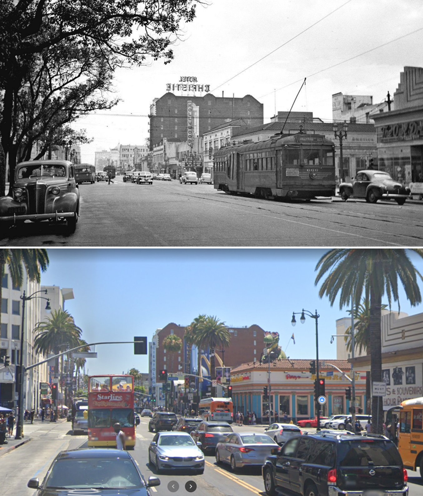
| (1943 vs 2022)* - Looking east on Hollywood Boulevard toward Highland Avenue. Even though the area isn’t what it used to be (to be kind), tourists still flock here….mainly because of its history. Photo comparison by Jack Feldman. |
Historical Notes In 1943, the intersection of Hollywood and Highland was a busy center for streetcars, hotels, restaurants, and local shopping. By 2022, decades of redevelopment had changed the character of the area, with the Hollywood and Highland complex and the Dolby Theatre turning it into a major tourist attraction rather than a neighborhood shopping street. Even so, the basic street layout and several older buildings still give hints of how the boulevard looked during the 1940s. |
 |
|
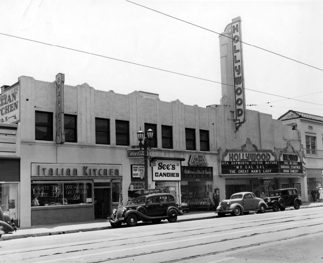
| (ca. 1942)* - View looking toward the south side of Hollywood Boulevard just east of Highland Avenue showing the Hollywood Theatre (6764 Hollywood Blvd). On the left is the Italian Kitchen Restaurant with large sign on face of building reading “Spaghetti”. Between the restaurant and theater is Hollywood Book Store and See’s Candies. The theater is featuring “My Gal Sal” with Rita Hayworth and Victor Mature. |
Historical Notes The Italian Kitchen Restaurant, seen on the left with its large Spaghetti sign, was one of many small restaurants that served both movie studio workers and local residents. Next door were the Hollywood Book Store and a See’s Candies shop, showing the variety of small businesses that once lined the boulevard. The Hollywood Theatre is advertising the Rita Hayworth and Victor Mature film My Gal Sal, which dates the scene to around 1942. By this time the theatre had already undergone major renovations, including a 1936 remodel by S. Charles Lee that gave the building the modern appearance visible in the picture. |
 |
|
| (ca. 1945)* - Christmas Noir on Hollywood Boulevard with the Hollywood Theatre and Hotel Drake (previously Hotel Christie) seen on the right. |
Historical Notes This nighttime Christmas scene reflects the dramatic lighting often seen in film noir movies, which were becoming popular in the 1940s. The Hotel Christie appears on the right shortly after it had been renamed the Drake Hotel. When it was built in 1922, the Christie was Hollywood’s first modern luxury hotel. The Hollywood Theatre next door continued to be a major movie house during the wartime and postwar years. The holiday decorations remind us that Hollywood Boulevard remained a lively shopping and entertainment street even during the challenges of World War II. |
 |
|
| (1945)* - A Christmas look east on Hollywood Boulevard from Highland Avenue. |
Historical Notes Hollywood Boulevard kept its Christmas decorations throughout the war as a way to lift people’s spirits, especially for servicemen visiting Los Angeles. Streetcars continued to run along the boulevard, and 1945 was one of the last peak years before ridership began to drop in the postwar period. Many of the buildings seen in this photo represent the final years of the boulevard’s earlier appearance, before later redevelopment projects and widening of the street changed the look of Hollywood Boulevard in the 1950s and beyond. |
* * * * * |
Hollywood and Ivar
 |
|
| (1945)* – View looking east on Hollywood Boulevard at Ivar Avenue. The Broadway-Hollywood Building can be seen on the right on the southwest corner of Hollywood and Vine. The Guaranty Building stands at left on the northeast corner of Hollywood and Ivar, and the Equitable Building is in the distance on northeast corner of Hollywood and Vine. Also, the Admiral Theatre can be seen on the north side of Hollywood between Ivar and Vine. |
Historical Notes The 12-story Guaranty Building is a Beaux Arts office building built in 1923 and designed by John C. Austin. It was added to the National Register of Historic Places in 1979. The building is currently owned by the Church of Scientology. |
 |
|
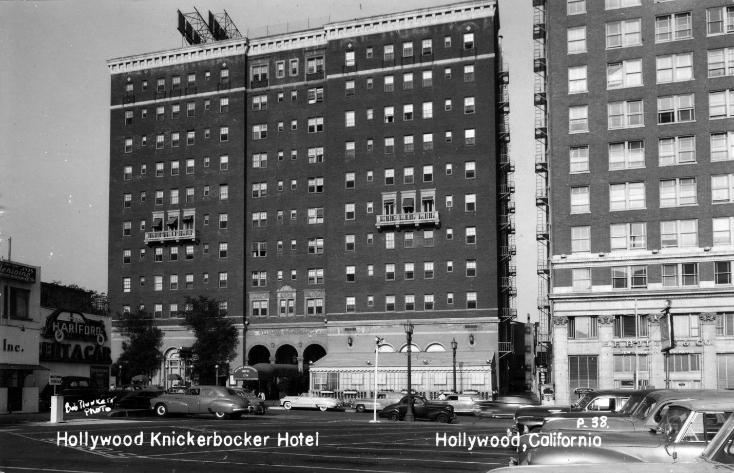
| ca. 1940s)* - Postcard view showing the Knickerbocker Hotel, located at 1714 N. Ivar Avenue. The Guaranty Building stands to the right of the Knickerbocker Hotel on the NE corner of Hollywood and Ivar. |
Historical Notes In 1923 E. M. Frasier built this 11-story hotel in Spanish Colonial style, which catered to Hollywood's film industry and was home to many stars throughout the years. This historic building began life as a luxury apartment building that was at the heart of Hollywood back in the 1920s, before becoming a hotel later in its history; its slogan was "Your home for a year or a day". |
 |
|
| (1940s)* – Postcard night view looking southeast from the Hollywood Hills showing the glittering lights of Hollywood, at the Hollywood and Vine District. Both the the Knickerbocker Hotel and Guaranty Building can be seen at center of photo. |
* * * * * |
Hollywood and Vine
 |
|
| (1945)* - Postcard view of a crowd looking at the electric billboard on the Taft Building. The view is from the north-west corner of Hollywood and Vine looking south-east. An early traffic sign is in the foreground and in the background the distinctive "hat" of the Brown Derby sign is visible. |
Historical Notes The intersection of Hollywood Boulevard and Vine Street in Hollywood became famous in the 1920s for its concentration of radio and movie-related businesses. An historical marker plaque placed at the site by The Broadway-Hollywood Department Store (SW corner) reads: Hollywood was given name by pioneers Mr. and Mrs. Horace H. Wilcox. They subdivided their ranch in 1887 and called two dirt cross-roads Prospect Avenue and Weyse Avenue. Prospect Avenue, the main artery, was renamed Hollywood Boulevard and Weyse Avenue became Vine Street. This was the origin of "Hollywood and Vine." The streets were renamed in 1910, when the town of Hollywood was annexed by the City of Los Angeles |
 |
|
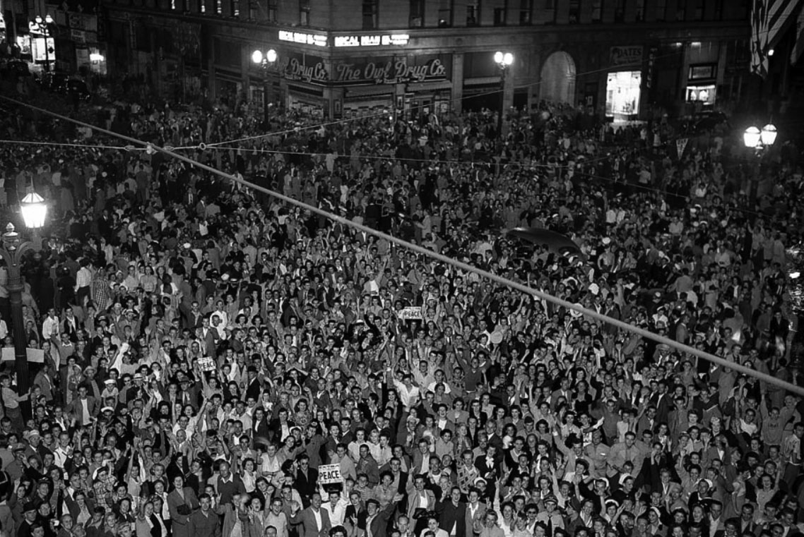
| (1945)* – Crowds at Hollywood and Vine celebrating surrender of Japan, ending World War II - VJ Day (Aug. 14, 1945). The Taft Building and The Owl Drug Co. can be seen in the background (SE corner). |
Historical Notes On August 6, 1945 the United States dropped an atomic bomb on the Japanese city of Hiroshima and on August 9, 1945 on the city of Nagasaki. These actions shocked the country and prompted Emperor Hirohito to order the Supreme Council for the Direction of the War to accept the terms the Allies had set down in the Potsdam Declaration for ending the war. On August 14, 1945, it was announced that Japan had surrendered unconditionally. Both August 14 and 15 have been known as "V-J Day" or "Victory over Japan Day." The term has also been used for September 2, 1945, when Japan formally surrendered aboard the U.S.S. Missouri, anchored in Tokyo Bay.* |
 |
|
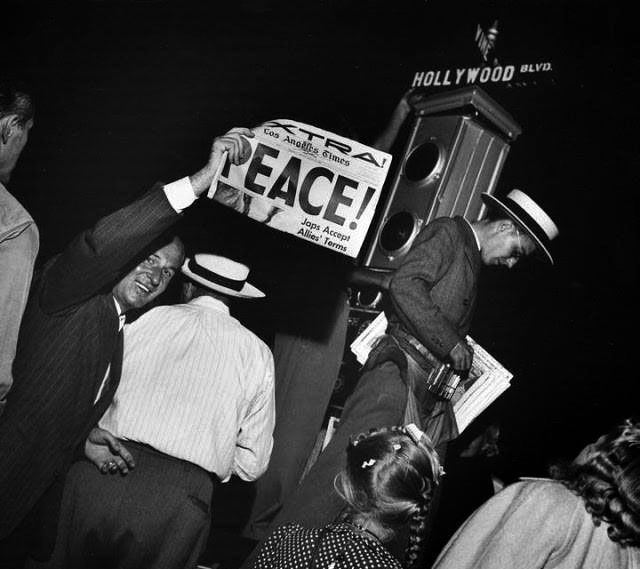
| (1945)* - VJ Day marking the end of the war on the corner of Hollywood and Vine. |
Historical Notes The exact date of the war's end is not universally agreed upon. It has been suggested that the war ended at the armistice of August 14, 1945 (V-J Day), rather than the formal surrender of Japan (September 2, 1945); in some European histories, it ended on V-E Day (May 8, 1945). However, the Treaty of Peace with Japan was not signed until 1951, and that with Germany not until 1990. |
 |
|
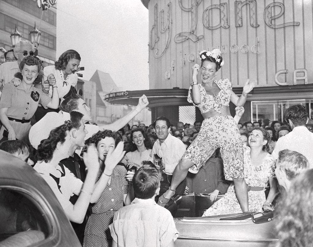
| (1945)* - Standing on the back seat of a car, actress Carmen Miranda puts her all into 'one of those Miranda' dances as she joins with others of the Hollywood clan in celebration of V-J day at the intersection of Hollywood and Vine with Melody Lane Cafe in the background. |
 |
|
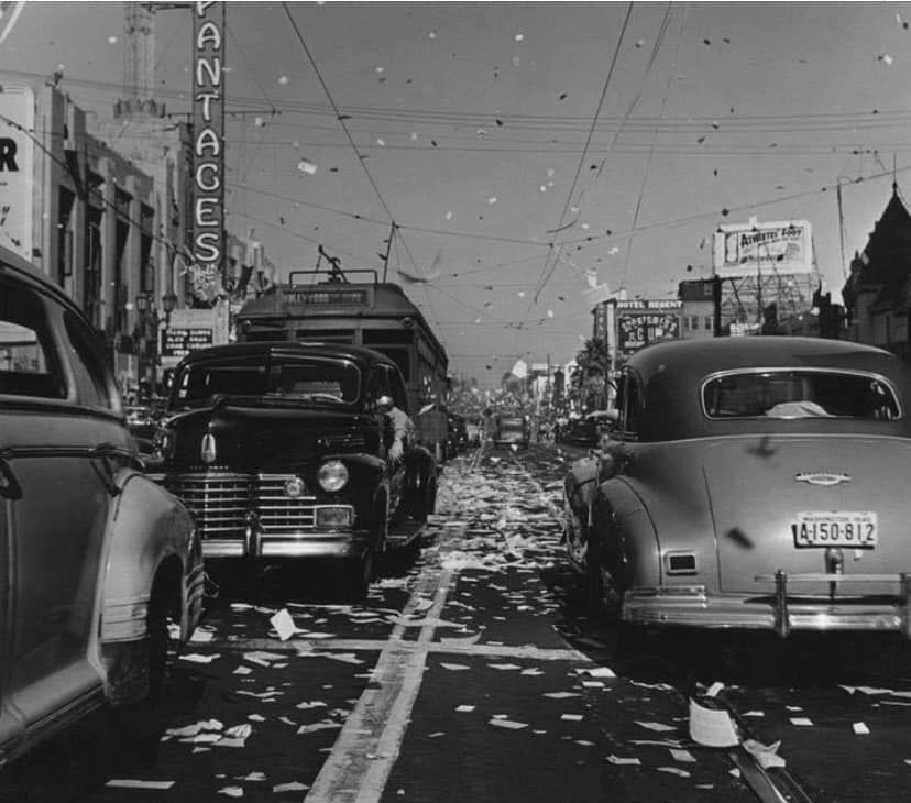
| (1945)* - V-J Day celebration on Hollywood Boulevard east of Vine near the Pantages Theatre. |
Historical Notes Click HERE to see more V-J Day celebrations in Downtown LA. |
 |
|
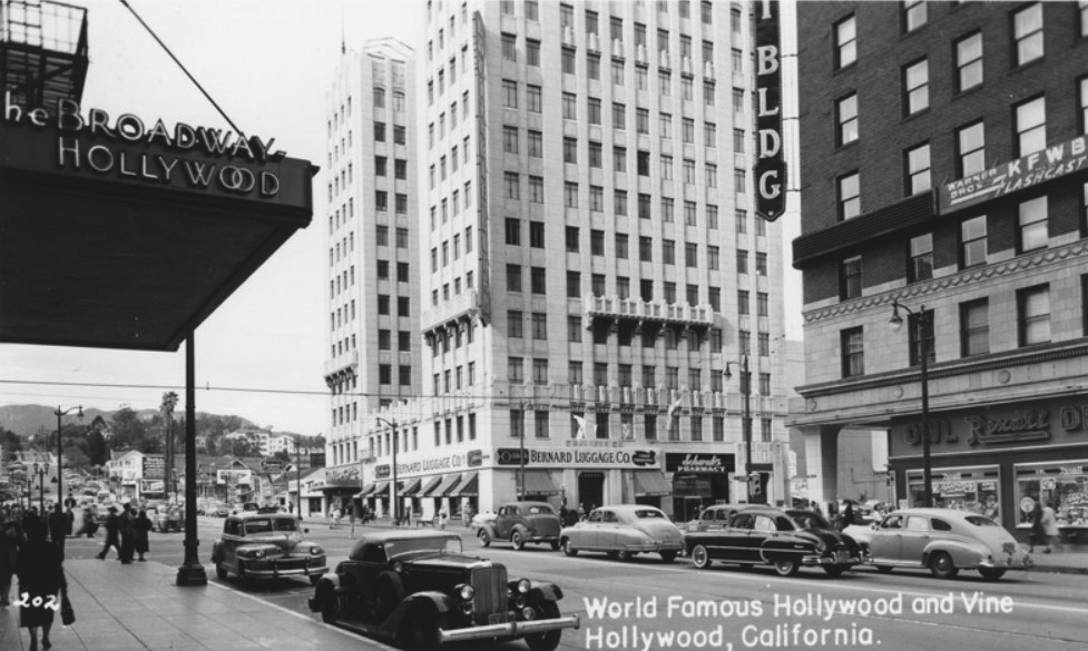
| (ca. 1948)* - Postcard view of Vine Street looking south from the front of The Broadway-Hollywood on southwest corner of Hollywood and Vine. The Brown Derby Restaurant can be seen down the block on the east side of Vine. |
Historical Notes The ten-story Broadway-Hollywood Building (originally B. H. Dyas Building) was constructed in 1928, It helped usher in a spatial shift that opened the doors for large-scale retail development outside of downtown Los Angeles. It also was the first department store to introduce women’s slacks (Click HERE to see more). |
 |
|
| (1940s)* - View of the Taft Building at 1680 N. Vine Street, S/E corner of Hollywood and Vine. The Owl Drug Company occupies the street level corner space. An early model bus is pulling through the intersection as pedestrians are crossing the street. |
Historical Notes A.Z. Taft, Jr. purchased the Hollywood Memorial Church on the southeast corner of Hollywood and Vine, tore it down, and built the 12-story Taft Building. All the movie studios had offices in the building as well as actors Charlie Chaplin and Will Rogers. The Academy of Motion Picture Arts and Sciences also resided there. Even Clark Gable's dentist was located in the building.* In 1999, the Taft Building and Neon Sign were designated Historic-Cultural Monument No. 666 (Click HERE to see complete listing). In 2014-15 the Taft Building got a $15-million makeover with a renovation that shored up its seismic strength and uncovered historic architectural details that were under wraps for decades. Click HERE to see more Early Views of the Taft Building. |
* * * * * |
Hollywood and Vine
 |
|
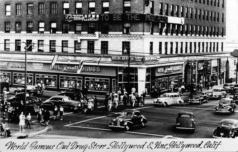
| (1940s)* - Postcard view of the intersection of "World Famous" Owl Drug Store on the ground floor of the Taft Building, southeast corner of Hollywood and Vine. |
Historical Notes The intersection of Hollywood Boulevard and Vine Street in Hollywood became famous in the 1920s for its concentration of radio and movie-related businesses. An historical marker plaque placed at the site by The Broadway-Hollywood Department Store reads: Hollywood was given name by pioneers Mr. and Mrs. Horace H. Wilcox. They subdivided their ranch in 1887 and called two dirt cross-roads Prospect Avenue and Weyse Avenue. Prospect Avenue, the main artery, was renamed Hollywood Boulevard and Weyse Avenue became Vine Street. This was the origin of "Hollywood and Vine." The streets were renamed in 1910, when the town of Hollywood was annexed by the City of Los Angeles |
* * * * * |
Xmas Deocrations
 |
|
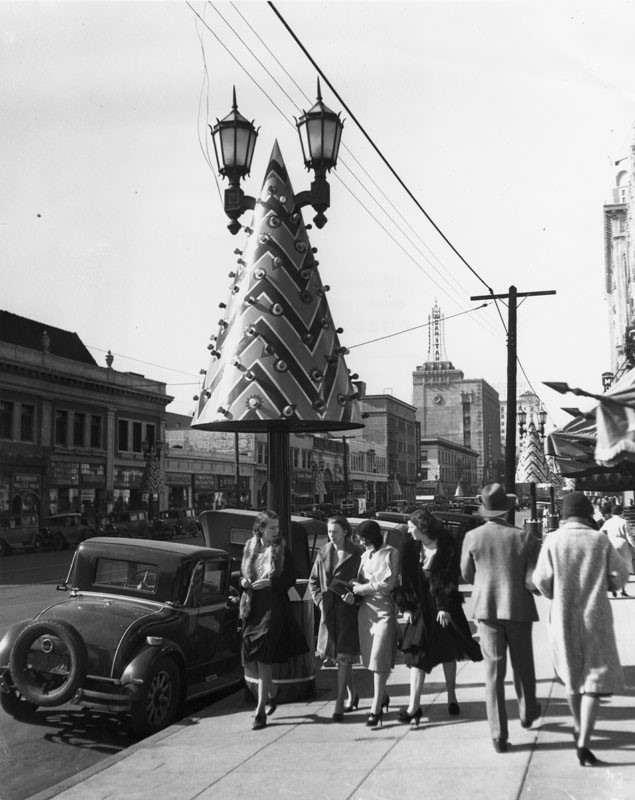
| (1929)* - Art Deco-inspired Christmas trees with chevron patterns attached to streetlights along Hollywood Boulevard. |
Historical Notes Christmas tree decorations along Hollywood Boulevard evolved significantly, reflecting the artistic trends of the time. Initially, live trees were used for decorations, but by 1929, the focus shifted to more stylized designs inspired by the Art Deco movement. These included chevron patterns and innovative streetlight adornments featuring tubular "candles." The decade saw the introduction of metallic tinsel trees, although they faced challenges with tarnishing and weather damage. |
 |
|
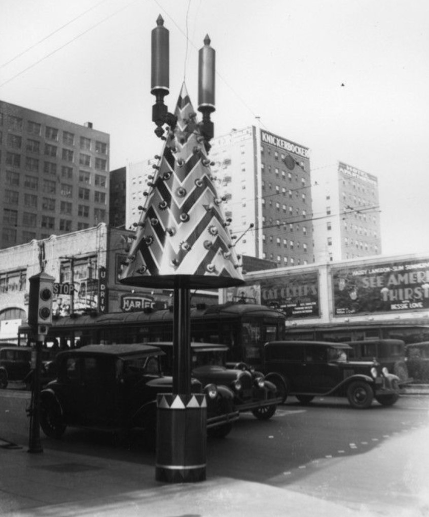
| (1930)* – A Christmas tree decoration stands next to a semaphore traffic signal on the southwest corner of Hollywood and Vine. Note how candle-like fixtures have replaced the original streetlight lamps. |
Historical Notes The most successful decorations during this period were conical metallic trees adorned with colorful light bulbs. These designs became iconic and remained in use from 1929 until the 1950s. Additionally, wreaths featuring photographs of Hollywood celebrities added a unique touch to the festive atmosphere. By the late 1930s, decorative elements such as ribbon signs proclaiming "Santa Claus Lane" were introduced, further enhancing the holiday spirit along the boulevard. |
 |
|
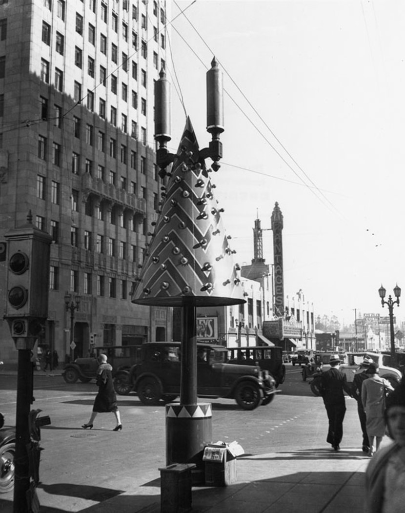
| (1930)* - View looking toward the Pantages Theatre from the southwest corner of Hollywood and Vine, where an Art Deco-inspired Christmas tree with a chevron pattern stands next to a semaphore traffic signal. Note how candle-like fixtures have replaced the original streetlight lamps visible in the distance. |
Historical Notes The annual transformation of Hollywood Boulevard into a festive wonderland not only celebrated the holiday season but also encouraged holiday shopping in the area. However, many of these decorative metal trees were eventually repurposed during World War II to support the war effort. Despite this loss, the tradition of decorating Hollywood Boulevard for Christmas left a lasting legacy and contributed to the boulevard's identity as a center of entertainment and celebration. |
 |
|
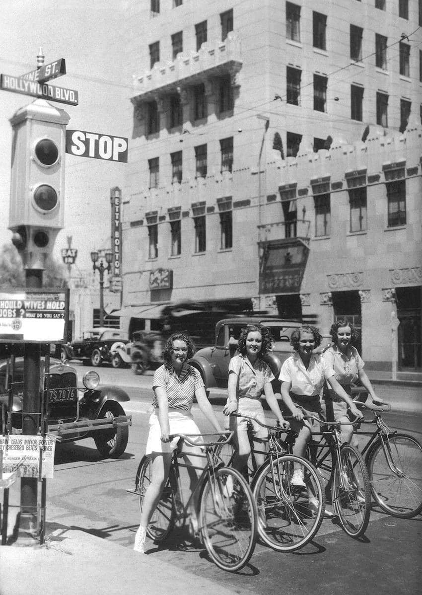
| (1933)* - Girls on bikes at the intersection of Hollywood and Vine with the Equitable Building seen in the background. |
Historical Notes Note the advertisement in front of the semaphore traffic signal: "Should Wives Hold Jobs"...a sign that things were changing. |
 |
|
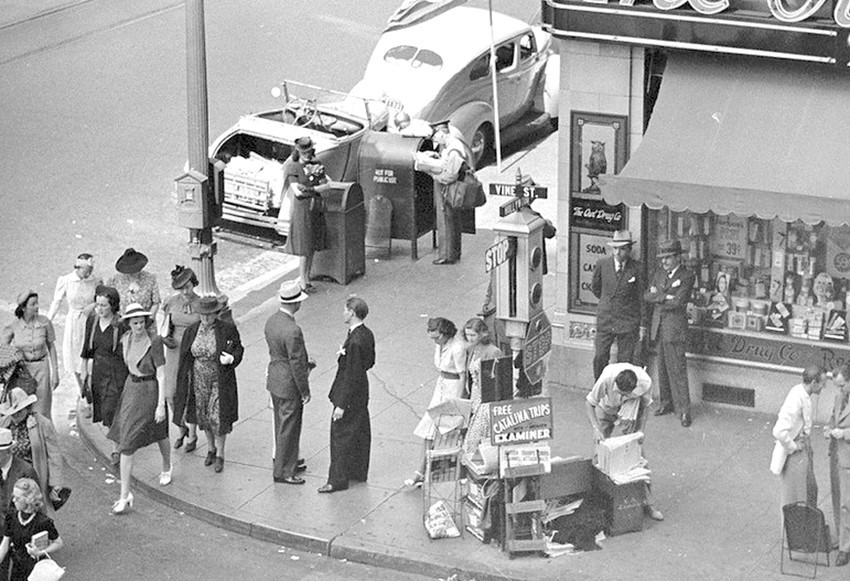
| (ca. 1939)* – Looking at regular daily life going on outside the Owl Drug Co. store in the Taft building at the southeast corner of Hollywood and Vine. Most of the people are in hats and the only guy not in a jacket is the post office worker near the top of the picture. The traffic signal is still the old semaphore style. Apparently, they made a “bong-clang” sound when they changed from Stop to Go. |
 |
|
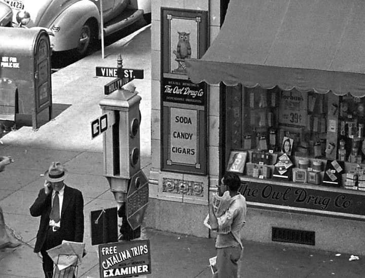
| (1940)* – Blow up view showing the Owl Drug Co Store located in the Taft Building on the SE corner of Hollywood and Vine. Note the Semaphore traffic signal on the corner. |
Historical Notes These early signals, manufactured by the Acme Traffic Signal Co., paired "Stop" and "Go" semaphore arms with small red and green lights. Bells played the role of today's amber or yellow lights, ringing when the flags changed—a process that took five seconds. Click HERE to see more on Early LA Traffic Signals. |
 |
|
| (1943)* - A man in a suit seems to be measuring the height of a sign attached to a streetlight post at the inersection of Hollywood and Vine with a semaphore traffic signal seen to the left. |
Historical Notes The Acme semaphore traffic signals at Hollywood and Vine represent a historical aspect of Los Angeles traffic management before the adoption of modern traffic lights. This significant intersection, known for its cultural and historical importance since the 1920s, was a bustling hub for the entertainment industry. The semaphore signals featured red and green lights to control traffic during the day, with a flashing yellow light at night to indicate caution and manage flow during off-peak hours. These signals allowed for dynamic responses to changing traffic conditions and could be manually adjusted in emergencies. Although no longer in use, the Acme semaphore signals played a crucial role in shaping early traffic management practices in Los Angeles, reflecting the city's evolution in urban infrastructure as it adapted to increasing vehicle volumes and safety standards. |
 |
|
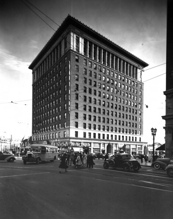
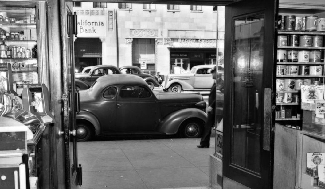
| (1940)* - Looking north from the Owl Drug Store at 6290 Hollywood Boulevard. California Bank and the Equitable Building can be seen across the street. |
Historical Notes The Owl Drug Company was a retailer with its headquarters in San Francisco. It was a subsidiary of Rexall stores at its peak in the 1920s through 1940s. The founder of the Owl Drug Company was Richard Elgin Miller, R.E. Miller. The company sold medicines and pills, and later ventured into cosmetics, perfumes, and other goods. The firm organized "Beauty Weeks", which included a range of fashion-related entertainment such as beauty contests judged by Elinor Glyn, in which winners received a Hollywood screen test. |
 |
|
| (1940s)^^^ - Postcard view looking east down Hollywood Boulevard at Vine Street. Visible from left to right are: The Equitable Building, Pantages Theatre, Taft Building, Owl Drug Store, and the Broadway-Hollywood. |
 |
(1944)**** - The corner of Hollywood and Vine. This location is noted for being the "DISCOVERY OF MOVIE STARS" location. The Owl Drug Store can be seen in the background (S/E Corner). LIFE Magazine
|
Historical Notes It's been touted as the world's most famous intersection. Radio station KFWB boasted that it broadcasted from the corner, and gossip columnist Hedda Hopper popularized it as a prime location for celebrity sightings. |
 |
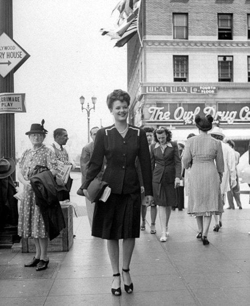
(1944)* – View showing a woman in a fashionable dress walking west on the south side of Hollywood Boulevard just west of Vine Street (same location as previous photo).
|
Historical Notes Note the sign pointing south down Vine to the Hollywood Victory House. Like the Victory House in Pershing Square, a central place to buy and sell war bonds. It opened in the forecourt of Graumann’s Chinese in May 1942, then moved near Hollywood & Vine. Also note the Pilgrimage Play sign. Click HERE to see more of the Pilgrimage Play Theatre (later the John Ford Theatre) located across from the Hollywood Bowl. |
 |
|
| (ca. 1945)*- View looking west on Hollywood Boulevard at Vine Street showing a Pacific Electric Railway heading east. The Broadway-Hollywood Building can be seen on the left (S/W corner). |
Historical Notes Streetcars ran in both directions down Hollywood Boulevard until 1953. |
 |
|
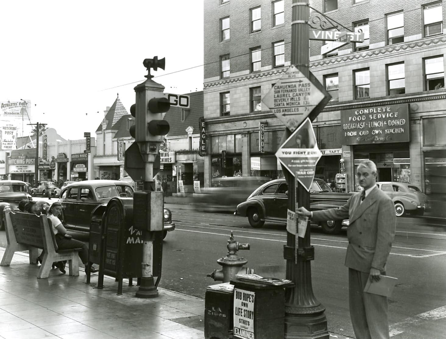
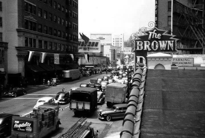
| (1947)* - View from northwest corner of Hollywood and Vine looking south. The man with the hat in the lower right is standing on the northwest corner. An early traffic sign is in the foreground and in the background the distinctive "hat" of the Brown Derby sign is visible. The Broadway-Hollywood stands across the street on the southwest corner. Note the STOP/GO Semaphore traffic signal at the corner. |
Historical Notes Los Angeles installed its first automated traffic signals in the 1920s. These early signals, manufactured by the Acme Traffic Signal Co., paired "Stop" and "Go" semaphore arms with small red and green lights. Bells played the role of today's amber or yellow lights, ringing when the flags changed—a process that took five seconds. |
 |
|
| (1940s)* – View showing a well-dressed woman at the southwest corner of Hollywood and Vine looking at the Broadway-Hollywood window display of hats. In the reflection can be seen two buildings across the street: Equitable Building (N/E corner) and Melody Lane Restaurant (N/W corner). Photo: Library of Congress |
* * * * * |
Melody Lane Restaurant
 |
|
| (1940s)* - View looking down from the roof of the Broadway-Hollywood showing the intersection of Hollywood and Vine. The Taft Building is on the right (S/E corner) and the famous Melody Lane is seen at upper-left (N/W corner). |
Historical Notes In 1940, restaurateur Sidney Hoedemaker of the Pig 'N Whistle - Melody Lane chain, leased the northwest corner of Hollywood and Vine and transformed it into a Melody Lane restaurant. He hired coffee shop modern architect Wayne McAllister and S. Charles Lee to do the design. |
 |
|
| (1947)* - View looking at the flooded intersection of Hollywood and Vine with the Melody Lane Cafe seen on the northwest corner. |
 |
|
| (1947)* - View looking west on Hollywod Boulevard at the intersection with Vine Street. The Melody Lane Cafe is on the northwest corner. Photo: Burton Frasher |
 |
|
| (1947)* - View toward the northwest corner of Hollywood and Vine, looking over an ornate two-lamp streetlight. The traffic signal at lower right shows "GO" even though the intersection is full of cross-traffic. Life Magazine |
Historical Notes By 1955, Melody Lane Restaurant, N/W corner of Hollywood and Vine, would be converted into Hody's Coffee Shop. This would be followed by Howard Johnson's in 1971, and the Brown Derby in the 1980s. The site became a slew of struggling retail and nightclubs such as; Premiere, Jack's Sugar Shack, the Deep, and finally the Basque nightclub. In April 2008 the building went up in flames and the lot has been empty since. Click HERE to see more of the N/W Corner of Hollywood and Vine. |
* * * * * |
 |
|
| (1947)^^^ – View looking northeast toward the Pantages Theatre from the southwest corner of Hollywood and Vine. Owl-Rexall Drug Store is on the southeast corner. |
Historical Notes In 1946, United-Rexall Drug Inc. launched the Owl Superstores chain. In 1947, the company held a gala opening for their new headquarters and first store in Los Angeles, California. The new Hollywood Owl was reported in Life Magazine as 'the World's Biggest Drugstore'. Rexall gained national exposure through its sponsorship of two famous classic American radio programs of the 1940s and 1950s: Amos and Andy and The Phil Harris-Alice Faye Show. Both shows were often opened by an advertisement from an actor (Griff Barnett) portraying "your Rexall family druggist", and included the catch phrase "Good health to all from Rexall." In 1958, the Rexall Drug Company was the largest U.S. drug store franchise, with 11,158 stores (for comparison, there are fewer than 12,000 McDonald's restaurants in the U.S. today).*^ |
 |
|
| (1947)* – View looking towards the Pantages Theatre from the southwest corner of Hollywood and Vine showing a very busy intersection. |
 |
|
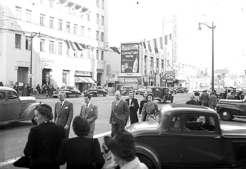
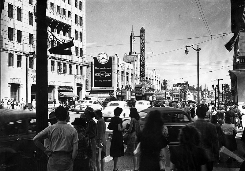
| (1948)* - Looking northeast across the busy intersection of Hollywood Boulevard and Vine Street, towards the Equitable Building and the iconic Pantages Theatre. To the west of the theater are Louque's Gowns, the Frolic Room, Roger's Liquors, a Foster and Kleiser billboard with a clock promoting Chevrolet automobiles, Harry Skepner's pharmacy, and a California Bank branch; to the east of the theater (right of center) is the A.E. England Pontiac dealership. |
 |
|
| (1949)* - Postcard view of Hollywood and Vine looking north. The Hotel Knickerbocker can be seen in the upper left. Melody Lane Restaurant is on the northwest corner. Note the curved one-arm streetlght. Click HERE to see more in Early L.A. Streetlights. |
 |
|
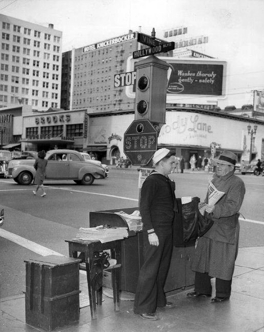
| (1940s)*# – View showing a sailor standing by a man holding a newspaper next to a small newspaper stand on the southeast corner of Hollywood and Vine. The Melody Lane Restaurant and Hotel Knickerbocker are seen in the background. Note the traffic signal and stop sign. |
 |
|
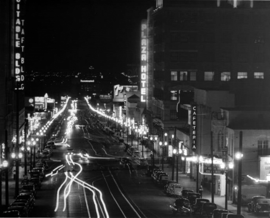
| (1940s)^^- Hollywood night scene looking south on Vine Street past the Hollywood Plaza Hotel. Included are: Taft Building, Bowling, Equitable Building. Photo by Dick Whittington |
 |
|
| (1940s)^** – Postcard night view looking south on Vine Street at Hollywood Boulevard the Taft Building and Owl Rexall Drugs (at left) and Broadway-Hollywood Building (at right), and the Brown Derby and Tom Breneman's Hollywood Restaurant in the distance. |
Sunset and Vine
 |
|
| (1940s)^^^ - Postcard view looking north on Vine Street from Sunset Boulevard. A multitude of signs and signboards can be seen throughout. |
 |
|
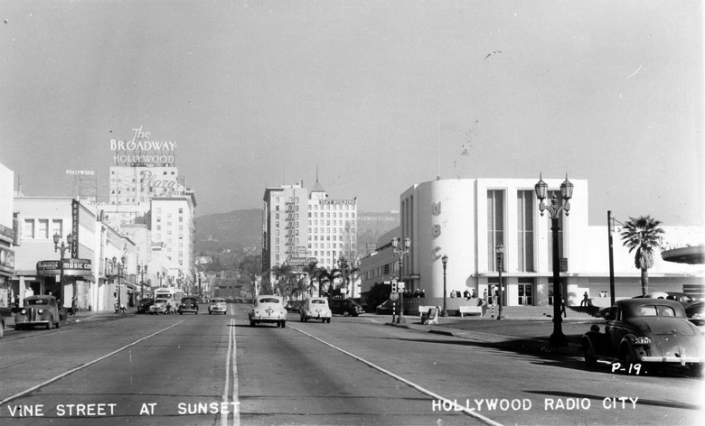
| (1940s)*# - View looking north on Vine Street at Sunset Boulevard. Building signage includes (r to l): NBC, KNBH Television, Taft Building, Broadway-Hollywood, Hollywood Plaza Hotel and Tom Breneman's Restaurant. |
Historical Notes KNBH (standing for “NBC Hollywood”) signed on in January 1949. It was the last of NBC’s five original owned-and-operated stations to sign on. It marked the debut of NBC television programs from the West Coast. The station changed its call letters to KRCA (for NBC’s then-parent company, the Radio Corporation of America) in 1954. The call letters were changed again in 1962, when NBC moved the KNBC identity from its San Francisco radio station (which became KNBR) and applied it to channel 4 in Los Angeles.*#^#* In the 1940s and 1950s when many broadcast studios were located on or near Vine Street the Hollywood Plaza Hotel became popular with radio people. George Burns even had offices at the top of the hotel. The popular radio DJ Johnny Grant did his show from the Hollywood Plaza Bar. Grant also did a radio show from midnight - 4:00 a.m. in the nearby Ham and Eggers Restaurant. |
 |
|
| (ca. 1939)^^ – View looking north on Vine Street showing two of the leading celebrity hangouts around the fabled corner of Vine Street and Hollywood Boulevard: Al Levy's Tavern (left) and, across the street, the Brown Derby, with the Plaza Hotel and Taft Building seen in the background. |
Ivar and Selma
 |
|
| (ca. 1940)* - Looking north towards the Broadway-Hollywood Department store and Plaza Hotel from the corner of Ivar & Selma. |
Historical Notes Ivar and Selma Weid, two children that crossed Daeida and Harvey Wilcox's land to get to school. When Harvey developed Hollywood in 1887 he named the two streets after them.^ |
Ivar and Hollywood
 |
|
| (ca. 1940)* – View looking east on Hollywood Boulevard at Ivar Avenue. On the corners can be seen Thrifty and Nancy's. In the distance, at Hollywood and Vine, is the Broadway-Hollywood. Click HERE to see contemporary view. |
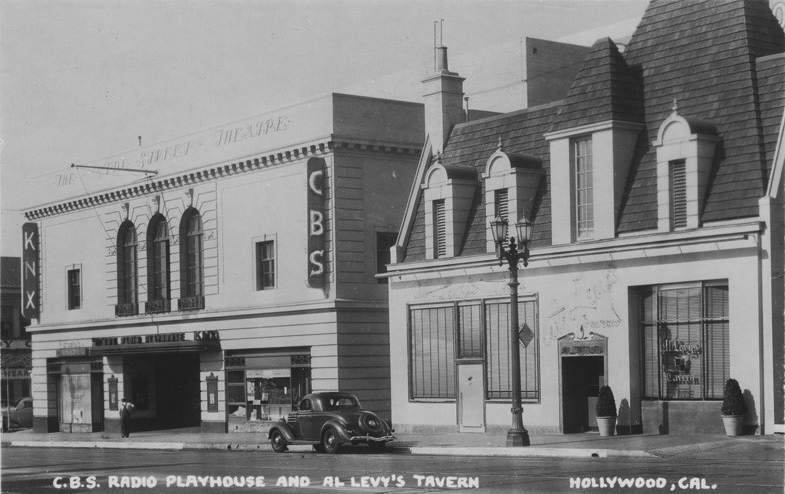
CBS Radio Playhouse and Al Levy's Tavern
 |
|
| (1941)^^^ - Postcard view showing the CBS Radio Playhouse at the Vine Street Theatre with Al Levy’s Tavern on the right. The Hollywood Plaza Hotel is out of view to the right. |
 |
|
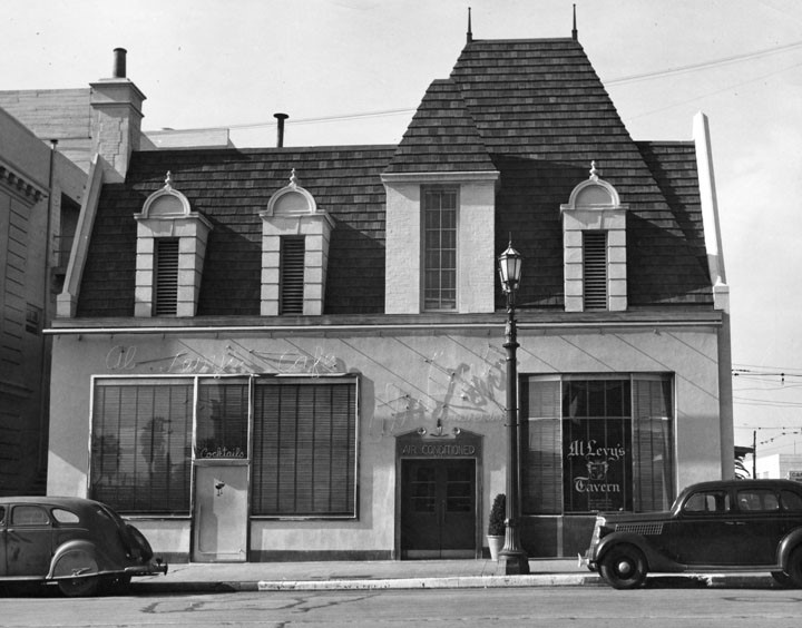
| (ca. 1940)* - A popular nightspot was Al Levy's Tavern at 1627 North Vine Street. It was located on the west side of Vine Street opposite the Vine Street Brown Derby. |
Historical Notes In 1894 the oyster cocktail was dreamed up by waiter Al Levy, who later became L.A.'s preeminent restaurateur. In 1916 Levy built a luxury restaurant in what was then the tiny farm town of Watts, so motorists could stop off to dine in grand style on their way to Long Beach. It evidently flopped. When Prohibition arrived in 1919, the country's dining habits changed, dealing a blow to old-fashioned dining establishments such as Levy's with their elaborate multicourse meals. In 1922 he started two restaurants side by side on Hollywood Boulevard, made a success of them and then sold them off in 1924. He took the money and immediately started a new downtown restaurant, Al Levy's Grill , on Spring Street in Downtown LA. Five years later, with his downtown chophouse well established, he was back in Hollywood with Al Levy's Tavern (seen above), which a contemporary described as "a Hollywood version of an English inn." It also featured a separate kitchen for kosher food. It was one of the three leading celebrity hangouts around the fabled corner of Vine Street and Hollywood Boulevard, along with Sardi's and the Brown Derby. ^ |
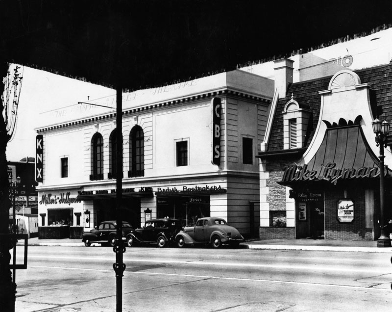
CBS Radio Playhouse and Mike Lyman's Grill
 |
|
| (ca. 1941)* - Exterior view of CBS Radio Playhouse (aka Vine Street Theatre), 1615 Vine Street. Located in the same building, on the left is Miller's Hollywood, on the right is British Bootmakers. Next door on the right is Mike Lyman's Play Room (formerly Al Levy's Tavern). |
Historical Notes Al Levy's Tavern was damaged by a 1941 fire and became a Mike Lyman's chain, which closed in 1959, according to an LA Times article from the same year.^#^#^ Mike Lyman was a former vaudeville entertainer from Chicago who opened his first Mike Lyman’s Grill in downtown LA in 1935. There he hired the chef from Maxim's in Paris hoping to ensure culinary success. Lyman opened a second Mike Lyman’s Grill in Hollywood and also created the Flight Deck, the first restaurant at what was then the Los Angeles Municipal Airport. Lyman’s restaurants were loyally populated by the A-Listers from the worlds of show biz and sports.^+^ Today, a multi-story parking garage is located where Al Levy's Tavern and Mike Lyman's Grill once stood, between the old Vine Street Theatre (Ricardo Montalbán Theater) and the Hollywood Plaza Hotel. Click HERE for contemporary view. |
* * * * * |
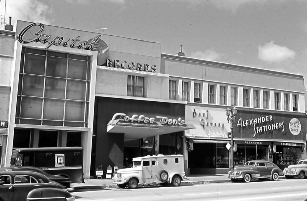
Capitol Records and Coffee Dan's
 |
|
| (ca. 1948)^##* – View looking toward the west side of Vine Street north of Sunset Boulevard. From left to right is Capitol Records, Coffee Dan’s (1511 N. Vine Street), Beni Gerson (tailor shop) and Alexander Stationers. Out of view to the right is Tom Brenemen’s Restaurant. The car parked outside Alexander Stationers is a 1948 Chevrolet Fleetline Aerosedan. |
Historical Notes In 1956, Capitol Records would move into its new 13-story Capitol Records Building located at 1750 N. Vine Street. Alan Hess, the author of Googie: Fifties Coffeeshop Architecture, traces Googie Architecture back to three Coffee Dan's restaurants designed by John Lautner in the early forties. "He selected the vaults and glass walls and trusses and angles of his buildings to fit the original, often unusual, concepts of space he favored," writes Hess. |
Tom Breneman's Restaurant
 |
|
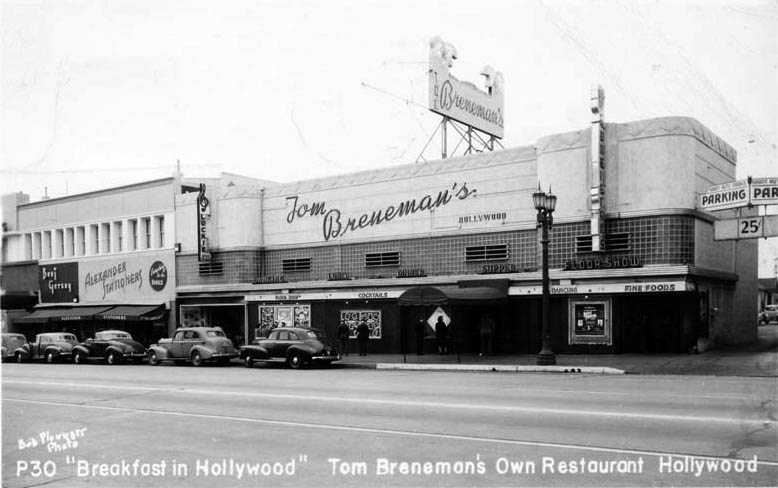
| (ca. 1947)^** - View of Tom Breneman's Own Restaurant, located on the west side of Vine Street, north of Sunset Boulevard. Beni Gerson Tailor Shop and Alexander Stationers can be seen on the left. |
Historical Notes Tom Breneman was host of the show Breakfast in Hollywood which aired on the Blue Network, ABC, NBC and Mutual at various times from 1941 to 1948. His program went through numerous title changes but was best known as Breakfast in Hollywood (1948-49). By the mid-1940s, Breneman had ten million listeners. The popularity of the radio program was such that he created his own magazine, and in 1945 he opened his own establishment that carried his name.*^ |
 |
|
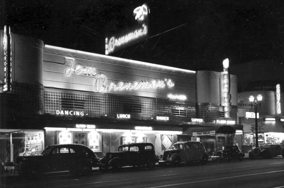
| (ca. 1947)*^ - Tom Breneman's Restaurant was located on Vine Street off Sunset. Breneman broadcast his Breakfast in Hollywood radio program from here in the late 1940s. |
Historical Notes At the age of 46, Breneman died April 28, 1948, in Encino, California, and other hosts, including Garry Moore, stepped in as replacements, but without Breneman, the ratings dropped, and the program came to an end in January 1949.*^ Later in 1949, American Broadcasting Company moved into the building with its AM radio station (KECA). |
* * * * * |
Warner Brothers Theatre
 |
|
| (1937)* - Cars line the street in this nighttime view of Wilcox from Selma looking north towards Hollywood Boulevard, which captures the Warner Brothers Hollywood Theatre in the distance. |
Historical Notes Architect G. Albert Lansburgh designed the Renaissance Revival style Warner Brothers Hollywood Theatre, which opened in 1928. The office space on the upper floors of the building became KFWB radio studios, which used the two radio masts on top of the theater. The building has also been known as the Warner Cinerama Theatre and the Pacific Hollywood Theatre.* |
 |
|
| (ca. 1938)* - Hollywood Blvd. looking east from Wilcox. On the north side of the boulevard are the Warner Bros. Theatre and the Security Trust and Savings Bank, which is located on the northeast corner of Cahuenga and Hollwyood.. |
* * * * * |
Hollywood and Cahuenga
 |
|
| (ca. 1938)^^ - A high-angle view of Hollywood Boulevard looking east from the intersection of Cahuenga Boulevard. The Owl Drug Company Buidling on the SE corner is seen at right. |
 |
|
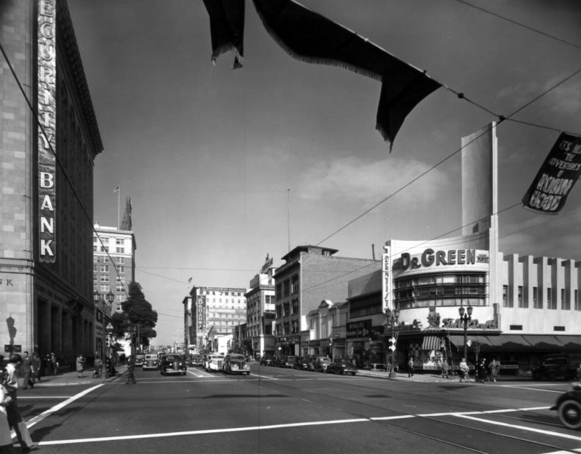
| (1938)^^ – View looking east on Hollywood Boulevard at Cahuenga Boulevard. At left, on the NE corner, stands the Security Trust and Savings Bank. At right, on the SE corner, is the Art Deco-style Owl Drug Company Buidling with large sign reading: DR. GREEN (dentist). A banner above Hollywood Boulevard hanging from a streetcar cable advertises The Adventures of Robin Hood movie. |
 |
|
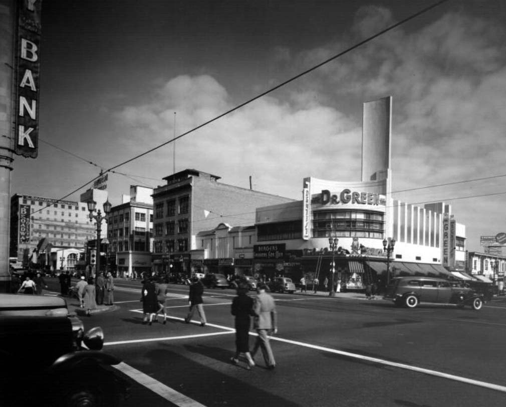
| (ca. 1940)^^ - View looking at the southeast corner of Cahuenga Boulevard and Hollywood Boulevard. Some of the legible signs include: Owl Drug Store, Security Trust and Savings Bank, Dr. Green, Berger's Fashions for Men, The Broadway-Hollywood, Nancy's, and Lloyds. |
 |
|
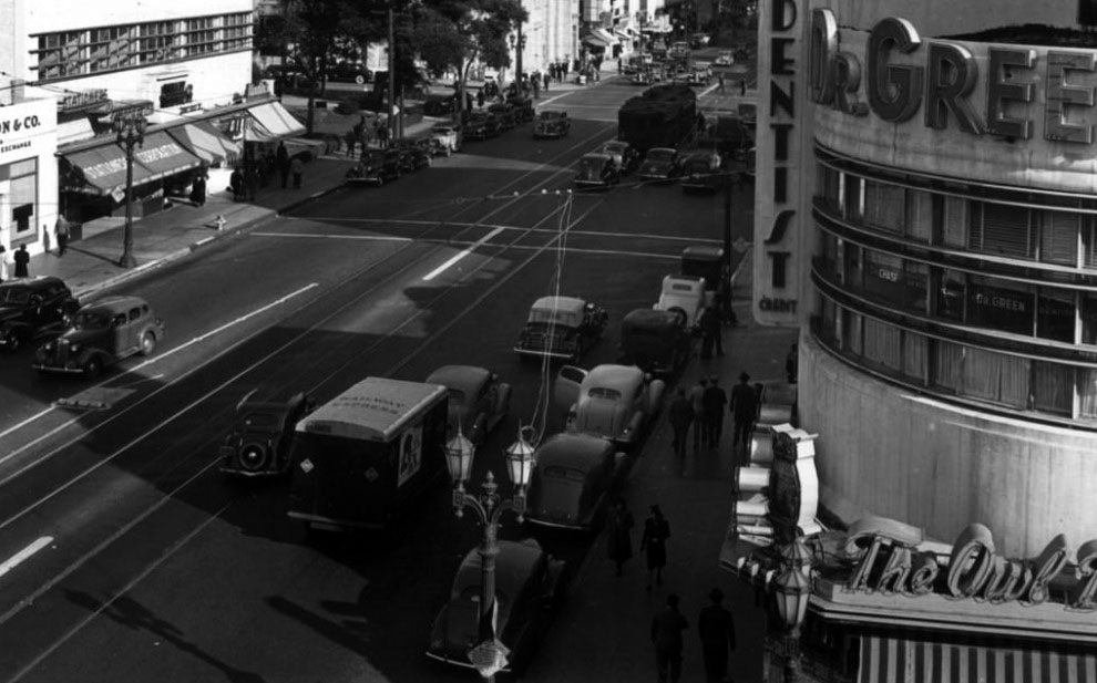
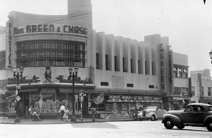
| (1943)#**# – Close-up view showing the building on the southeast corner of Cahuenga and Hollywood boulevards. Owl Drug Store is on the ground floor with Drs. Green and Chase (Dentists) on the second floor. The building still exists today. Click HERE for contemporary view. |
Historical Notes The southeast corner of Hollywood and Cahuenga boulevards was where the original old Hollywood Civic Center was located. The old city hall was known as Wilcox Hall. In 1933, the site was redeveloped with the entire block demolished and replaced with a streamline modern-style structure named the Julian Medical Building (aka Owl Drug Company Buidling). The Beveridge family (Daeida Wilcox Beveridge), who built Wilcox Hall, financed the development.^ |
 |
|
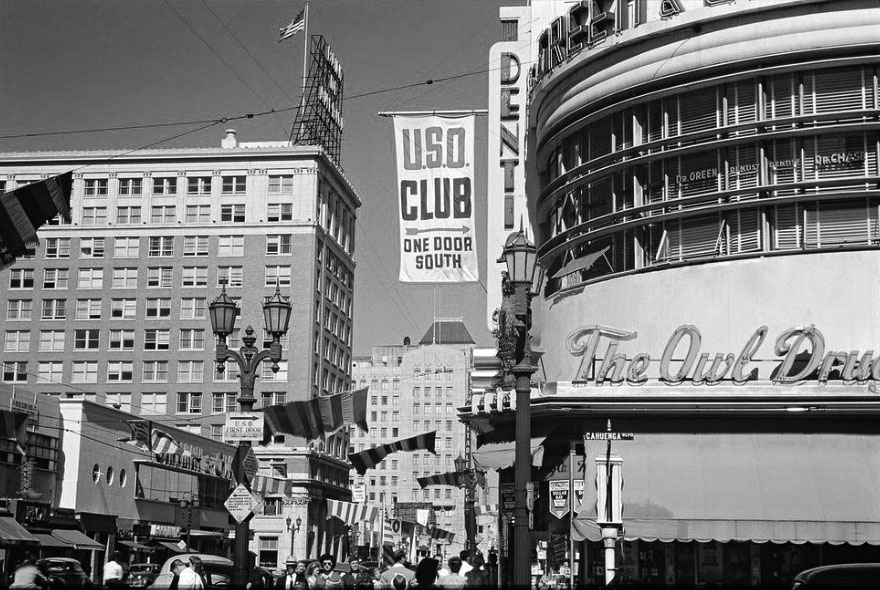
| (ca. 1943)^##* - Looking east on Hollywood Boulevard from Cahuenga Boulevard. U.S.O. Club banner extends out from the side of the Owl Drug Company Buidling |
 |
|
| (1949)* - View looking west on Hollywood Boulevard from just east of Cahuenga Boulevard. Seen are the Warner Bros. Theatre (later Hollywood Pacific Theatre), a Pacific Electric streetcar, various businesses, a Foster and Kleiser billboard for Pleasant Moments whisky, and the Hollywood branch of Security-First National Bank (the Security Trust and Savings Bank). |
* * * * * |
 |
|
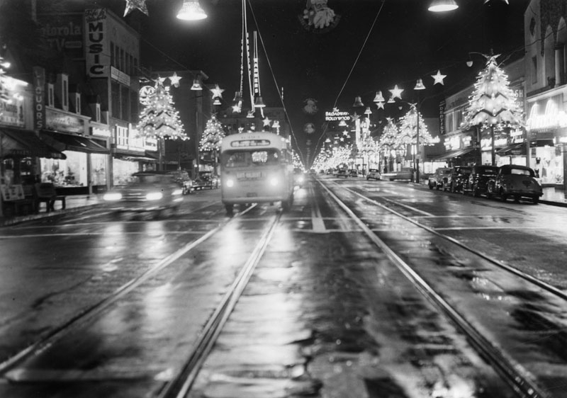
| (ca. 1948)* - Looking east on Hollywood Blvd. at night during the holiday season. The Broadway-Hollywood is visible in the background on the right and the Warner Pacific Theatre is seen on the left. Pacific Electric streetcar tracks run in both directions down the center of the boulevard. |
 |
|
| (ca. 1948)^^^ – Postcard view looking north toward the intersection of Hollywood and Vine as seen from the front of the Broadway-Hollywood. The Taft Building can be seen across the street on the southeast corner and the Equitable Building stands tall on the northeast corner. |
 |
|
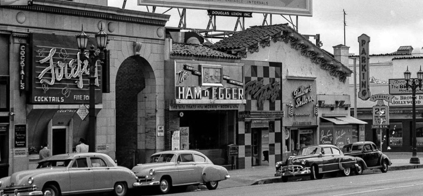
| (ca. 1950)* - View looking at the east side of Vine Street just south of Hollywood Boulevard. The Firefly Bar (on the left) is located on the ground floor of the Taft Building. The Ham ‘n Egger is seen at center with Giddlow and Sellers Barber Shop at center-right. To the right of the barber shop is Mooney and Kaye which is in the process of being converted into Jerry Lewis' Camera Shop. And finally at far right can be seen the edge of the Brown Derby Restaurant. The Spanish-style building at right is the Herman Building, still standing today. |
Historical Notes The Herman Building (seen above) was part of a complex of Spanish Colonial Revival buildings designed by architect Carl Jules Weyl that included the Hollywood Brown Derby Restaurant, to the right and out of view. Over the years, the Herman Building was home to many businesses, most notably a restaurant in the 1940s-1950s called the Ham & Egger. Johnny Grant, who went on to become the Honorary Mayor of Hollywood, broadcast a live radio show from the restaurant where he interviewed such famous celebrities of the day as Bob Hope, Jimmy Durante and Alan Young. Click HERE to see what remains of the Herman Building today. |
 |
|
| (ca. 1949)* – Roofline view over the Brown Derby Restaurant looking north on Vine Street. Traffic is backed up all the way from Hollywood Boulevard where you can see crowds of people gathering for some event, possibly a parade. |
 |
|
| (1949)* - Postcard view looking north on Vine Street just south of Sunset Boulevard. NBC's Hollywood Radio City can be seen on the corner. |
 |
|
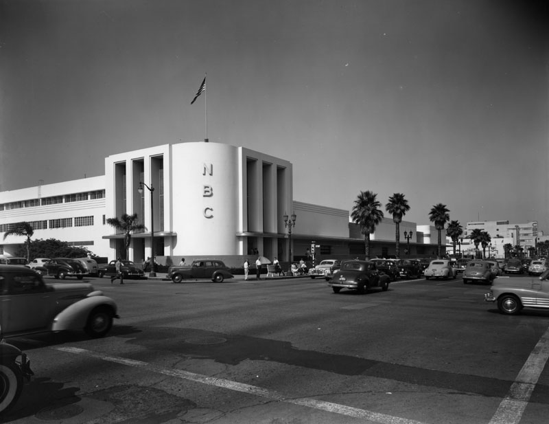
| (ca. 1949)* - Taken from across the street, this view captures the National Broadcasting Company Studios, located on the northeast corner of Sunset Boulevard and Vine Street. |
Historical Notes In 1964 the West Coast Radio City building was demolished, as NBC moved more of their West Coast television operations to the Burbank facility. The site is now occupied by a bank. |
* * * * * |
Don Lee Mutual Broadcasting Studios
 |
|
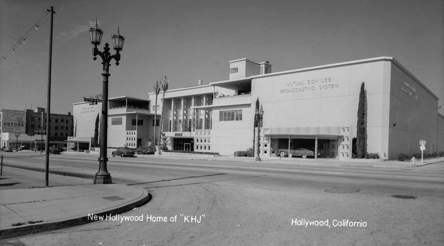
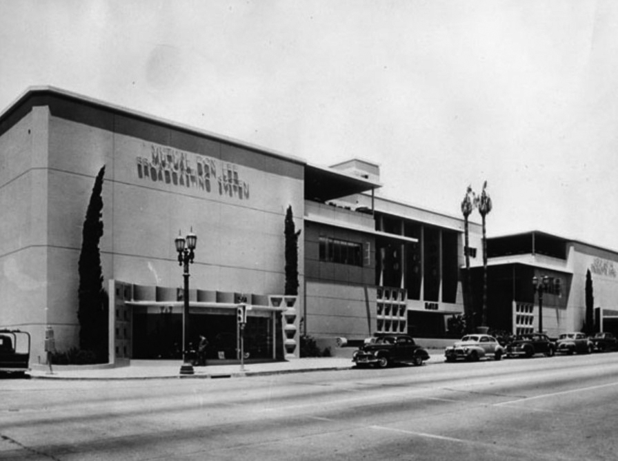
| (1949)* – Postcard view showing the Mutual Don Lee Broadcasting Studios, now the “New Hollywood Home of KHJ” among others. Note the window display of a "new" Cadillac in front of building. Photo by Bob Plunkett from the Ernest Marquez Collection. |
Historical Notes In 1948, the Don Lee Mutual Broadcasting Studios opened a groundbreaking new facility at 1313 North Vine Street in Hollywood. This $2.5 million complex was among the first in Hollywood built specifically for both radio and the emerging medium of television. Designed by Claud Beelman and Herman Spackler, the three-story building featured 14 broadcast studios, including four large sound stages that could accommodate live audiences and full orchestras. Its innovative design included a lobby with a plate glass wall, allowing visitors to observe the network’s operations-a testament to the studio’s modernity and transparency. Though the building was never used for selling Cadillacs, the windows provided direct advertising for the latest models of the owner’s other business. |
 |
|
| (ca. 1949)* - View showing the Mutual-Don Lee Broadcasting Studio located at 1313 North Vine Street. |
Historical Notes The building opened on August 18, 1948, as the headquarters of the Mutual-Don Lee broadcast empire. Designed by Claud Beelman -- the architect behind such local landmarks as the Hollywood Post Office, Eastern Columbia Building and the Culver Hotel -- and his associate, Herman Spackler, it was larger than its compact, three-story profile suggested. Inside were 14 separate broadcast studios, including four large sound stages with auditorium seating for live audiences. The Don Lee Network had been a major force in West Coast broadcasting since the 1920s and became the western partner for the Mutual Broadcasting System in 1936, helping Mutual achieve nationwide coverage. By 1948, the new Hollywood studios symbolized the network’s ambition to lead in both radio and television, producing a diverse mix of local and national programs. This facility quickly became a hub for entertainment, news, and variety shows that reached audiences across the country. |
 |
|
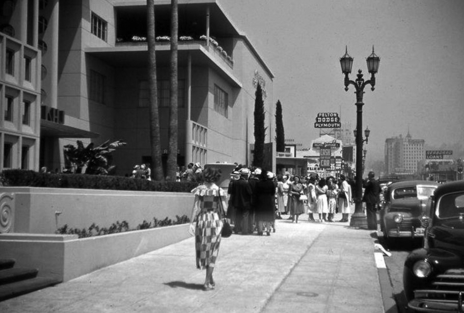
| (ca. 1949)* – View looking north on Vine Street showing a woman walking toward a group of people in front of the Mutual-Don Lee Broadcasting Studio. |
Historical Notes The Don Lee Mutual Building at 1313 Vine is an 118,000 square-foot building that was a state-of-the-art broadcast facility for radio and television. It was the culmination of a broadcasting dynasty begun by Don Lee, who held the franchises for California and Nevada Cadillac dealerships, fostered Los Angeles radio, and was a leading pioneer of television on the West Coast. |
 |
|
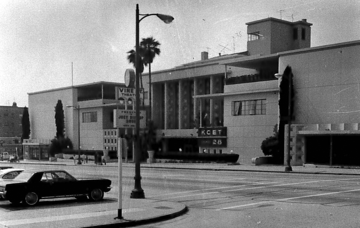
| (ca. 1964)* - View showing the Don Lee Mutual Broadcasting Studios with a KCET Channel 28 sign on the front of the building. |
Historical Notes KCET was the first Los Angeles station devoted exclusively to educational programming when it signed on the air on September 28, 1964. It was also among the city's first UHF channels. Other stations had already claimed the available VHF channels -- 2, 4, 5, 7, 9, 11, and 13 -- and so KCET broadcasted at Channel 28 on a frequency not all television sets were then equipped to receive. ABC acquired the facility in 1970 and produced such shows as "The Dating Game" and "The Newlywed Game" there. In the 1990s AIDS Project Los Angeles moved in, and since 2002 the historic Mutual-Don Lee Building has housed the Academy of Motion Picture Arts and Science's Pickford Center for Motion Picture Study and the Academy Film Archive. The former Don Lee Mutual Broadcasting Studios building at 1313 North Vine Street in Hollywood now serves as the Pickford Center for Motion Picture Study, a facility owned and operated by the Academy of Motion Picture Arts and Sciences. The Academy acquired the building in 2000 and remodeled it, officially opening it as the Pickford Center in 2002, named after Mary Pickford, a founding member of the Academy. Today, the Pickford Center houses the Academy Film Archive, the Science and Technology Council, the Grants and Nicholl Fellowship programs, and other Academy departments. It also features the Linwood Dunn Theater, a 286-seat venue used for public events and screenings of Academy Award-eligible films. The building has been extensively upgraded with temperature-controlled storage and a sophisticated fire suppression system to preserve valuable film materials. This historic building is recognized as Hollywood’s oldest surviving studio specifically designed for television broadcasting, maintaining its legacy in the entertainment industry while serving as a vital hub for film preservation, study, and public programming. |
* * * * * |
Tiny Naylor's Restaurant and Drive-in (Sunset and La Brea, NW Corner)
 |
|
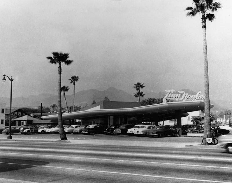
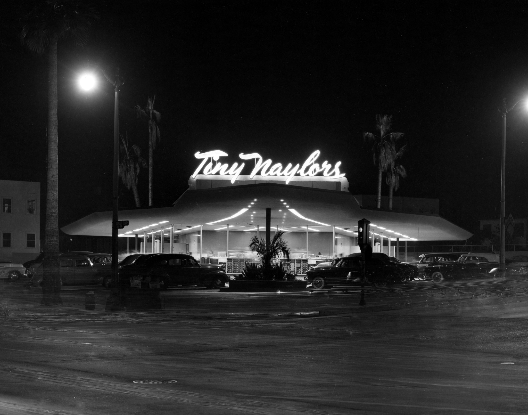
| (1949)* - View showing a full parking lot at Tiny Naylor's Restaurant and Drive-in, located on the northwest corner of Sunset and La Brea in Hollywood. |
Historical Notes This is the original location of "Tiny Naylor's" (1949-1980), one of the most popular drive in restaurants during the Golden Age of Hollywood. Many movie stars would go to this "space age" styled building to eat, because they could be served their meal in their cars and remain unnoticed. The restaurant was open 24 hours a day and was a great example of "Googie" Architecture. This is the same corner where McDonnell's Drive-in (not to be confused with McDonalds) once stood in the 1930s and early 1940s. |
 |
|
| (1949)* – View looking toward the northwest corner of Sunset and La Brea showing Tiny Naylor’s Drive-in Restaurant. Note the old style traffic signal (semaphore traffic signal) on the corner. Photography by Marc Wanamaker–Bison Archives |
Historical Notes Tiny Naylor’s was also distinguished with its menu. Besides burgers and shakes, the menu at Tiny Naylor’s also included corn on the cob, ribs, steak, and baked potatoes—all of which were unheard of for a drive-in. Everything served at the restaurant was made from fresh ingredients, never frozen. |
 |
|
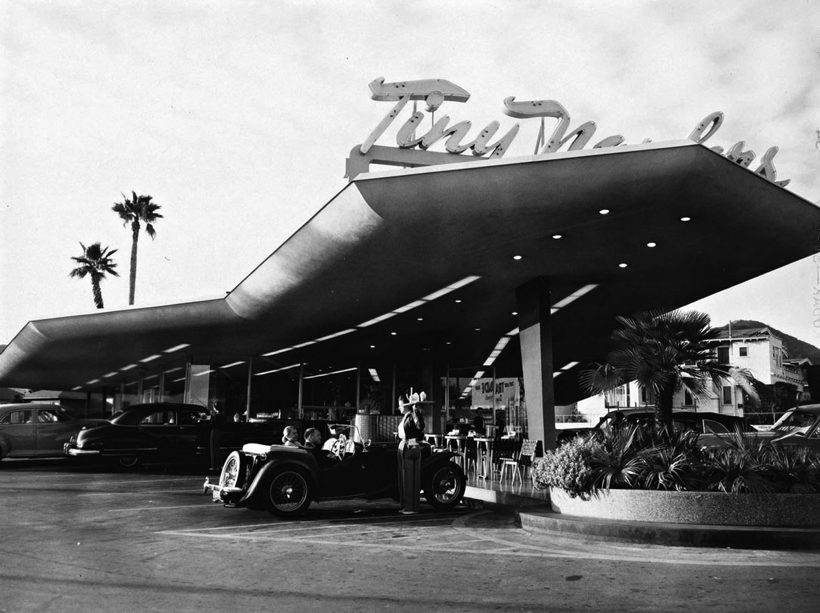
| (1952)* – View showing a couple in an MG being served by a carhop at Tiny Naylor's. Photo by Julius Shulman / Getty Research Institute |
Historical Notes The fabulous Tiny Naylor’s Drive-in Restaurant was built in 1949, from the mind of googie architect Douglas Honnold. He, along with John Lautner, also designed the Googie-style Coffee Dan’s on Wilshire Boulevard. Click HERE to see more on Googie Architecture. Douglas Honnold (1901 – 1974) was an award-winning Canadian-born American architect. He, along with John Lautner, designed the Beverly Hills Club. They also designed the Embassy Shop in Beverly Hills, which won an Honor Award from the Southern California Chapter of the American Institute of Architects in 1947. Additionally, they designed the Coffee Dan's Restaurant buildings on Vine Street in Hollywood as well as on Broadway in Downtown Los Angeles in 1946. Honnold is also known for turning down the offer to design the famous McDonald's golden arches. |
 |
|
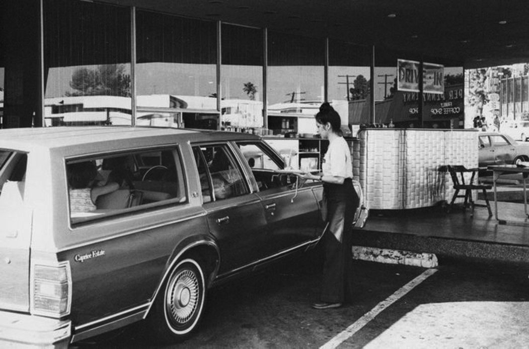
| (1970s)* - Family packed in a Chevrolet Caprice Estate station wagon being served at Tiny Naylor’s. Reflection in window shows Copper Penny Restaurant across the street. |
Historical Notes Although Tiny Naylor was best known for his Tiny Naylor's restaurant chains, his first restaurant was Biff's Coffee Shop – named after his son, in 1948. It was located on the corner of Cahuenga and Yucca in Hollywood. |
 |
|
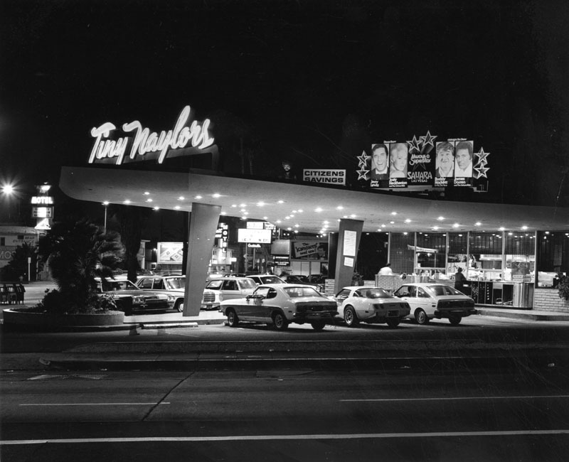
| (1980)* - Nighttime view of Tiny Naylor's Restaurant, located at Sunset Boulevard (left) and La Brea Avenue (foreground). Photo by Roy Hankey |
Historical Notes Unfortunately, Tiny Naylor’s went out of business in 1980 and the Googie-style structure was subsequently demolished to make room for a shopping center. The Naylor family is still alive and well in the restaurant business, however, with the Du-Par’s chain of restaurants. Today an El Pollo Loco stands at the corner where Tiny Naylor's once stood. Click HERE to see more Early Views of LA Drive-in Restaurants. |
* * * * * |
Carolina Pines Jr. Restaurant (later Copper Penny)
 |
|
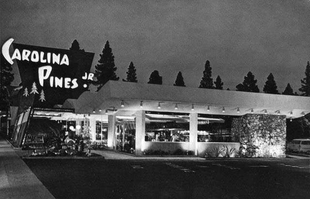
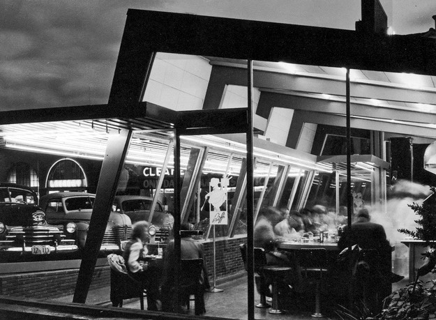
| (1950s)* - Postcard view showing the Carolina Pines Jr. Restaurant located at 1518 N. La Brea, just north of Sunset Boulevard. Note the pine trees on the other side of the restaurant. Photo courtesy Vintage Everday |
Historical Notes Carolina Pines Jr. was a “Googie” style modern diner located near the northeast corner of Sunset and La Brea from 1952 until the early 1960s. The restaurant was flooded with lights at night and was open 24 hours a day. What distinguished this coffee shop from the others was their menu was all "Southern Style" cooking and you could order your breakfast eggs with grits and biscuits. The restaurant was named after the pine trees just a few yards north of the restaurant, which remain there to this day. In the late 1960s, the restaurant was remodeled and was a "Copper Penny" coffee shop, a chain owned by IHOP. The building was finally torn down for the present day mall. There was also a second location at 525 South Vermont Ave. |
 |
|
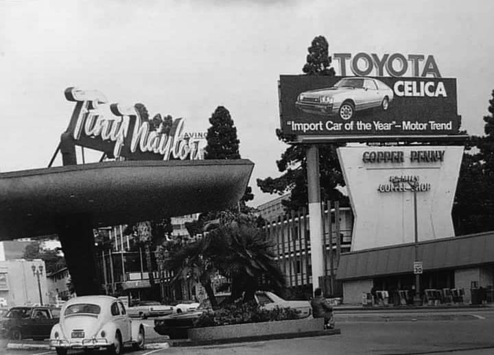
| (ca. 1978)* – View looking northeast from the corner of Sunset Boulevard and La Brea Avenue showing Tiny Naylor’s Restaurant and the Copper Penny Coffee Shop (previously Carolina Pines Jr. Restaurant). Photo courtesy Vintage Hollywood |
Historical Notes The menus at the Copper Penny Coffee Shop were printed on huge plastic copper pennies with a very good selection of breakfasts. Click HERE to see contemporary view of Sunset and La Brea. |
* * * * * |
Biff's Coffee Shop
 |
|
| (1950)* – View of Biff’s Coffee Shop near the corner of Cahuenga Blvd. and Yucca Street. |
Historical Notes Although Tiny Naylor was best known for his Tiny Naylors restaurant chains, his first restaurant in the area was Biff’s – named after his son, in 1948. It was located on the corner of Cahuenga and Yucca in Hollywood. Tiny Naylor died in 1959. In 2004, the Naylor family purchased the Du-par's restaurant chain, from the Oberst family. Du-par's expanded in 2009 by acquiring several locations from the bankrupt Bakers Square chain. However, the Naylor family's ownership of Du-par's was short-lived. In 2018, Frances Tario, a former manager who had risen through the ranks since starting as a waitress in 2004, purchased Du-par's, becoming its new owner. |
 |
|
| (1950s)* – This early photo of Hollywood offers a lot to see. The view looks southeast at the intersection of Cahuenga Boulevard and Yucca Street, where the Halifax Hotel stands on the corner. In the distance, the Capitol Records building is clearly visible. Several large signs stand out, including one for the Hotel Knickerbocker. At the lower left, a sign for Biff’s Coffee Shop points toward a lot adjacent to the corner Union 76 station. |
Historical Notes The Halifax was known for it's gangster clientel in the 1930's and 1940's. Across the street, on the north side of Yucca (next to the Richfield station) was the apartment building where Ed Wood lived when he filmed most of his movies. The cool little Googie restaurant on the north side of Yucca Street was across from the Green Apartments, where Carol Burnett lived with her grandmother while attending Hollywood High in the 1950's. |
* * * * * |
 |
|
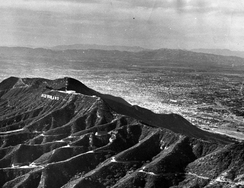
| (1948)* - Aerial view of the San Fernando Valley. View shows the "HOLLYWOODLAND" sign on the mountain. The letter "H" is missing. Within months of the time this photo was taken the sign would be shortened to read "HOLLYWOOD". Photo dated: December 13, 1948. |
Historical Notes During the 1940s, Albert Kothe (the sign's official caretaker) caused an accident that destroyed the letter H. Kothe, driving while inebriated, was nearing the top of Mount Lee when he lost control of his vehicle and drove off the cliff directly behind the H. While Kothe was not injured, his 1928 Ford Model A was destroyed, as was the original 50 foot tall illuminated letter H. The HOLLYWOODLAND sign was erected in 1923 to advertise a new housing development in the hills above the Hollywood district of Los Angeles. In 1949 the Hollywood Chamber of Commerce contracted to repair and rebuild the sign. The contract stipulated that “LAND” be removed to reflect the district, not the housing development.*^ |
 |
|
| (1940s)+^^ – View looking north toward the Hollywood Hills showing the Mountain States Building standing on the NW corner of Vine and Yucca streets (on the left). The Capitol Records Building would be built at lower-left in the 1950s, near the SE corner of Vine and Yucca. The Hollywood Freeway would also be built in the 1950s and would run across the top of the photo about one block north of Yucca Street. |
 |
|
| (ca. 1955)#*## – Aerial view looking northwest showing the Mountain States Building standing in the shadows of the newly completed Capitol Records Building across the street. |
Cahuenga Pass
 |
|
| (ca. 1930s)^^ - Panoramic aerial view of Hollywood showing the Chauenga Pass as it heads towards the San Fernando Valley. The major street running from bottom left diagonally up toward the Cahuenga Pass is Highland. The Security Pacific Bank building tower on Hollywood and Highland can be seen at left-center of photo. |
 |
|
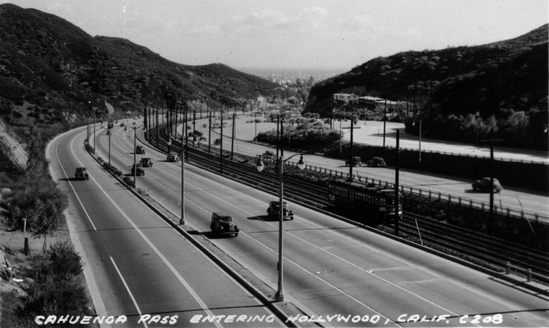
| (1930s)^^^ – Postcard view showing Cahuenga Pass entering Hollywood with streetcar running in center median. |
 |
|
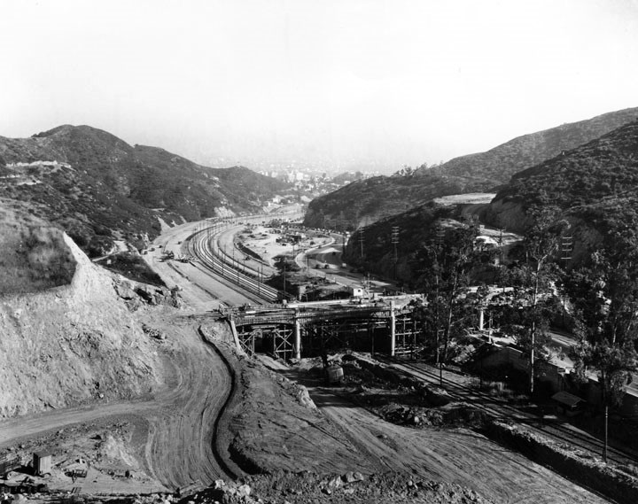
| (ca. 1939)* - View of Cahuenga Pass looking towards Hollywood showing the construction of the Mulholland Drive Bridge. Mulholland Drive (originally Mulholland Highway) can be seen winding its way up the hill at right. |
Historical Notes When it officially opened on December 27, 1924, Mulholland Highway was 24 miles long, running from Cahuenga Pass to Calabasas. The name was changed to Mulholland Drive in 1939. |
 |
|
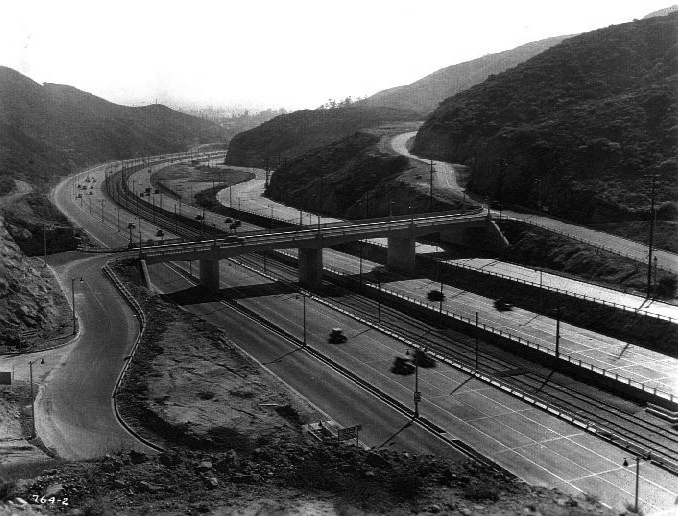
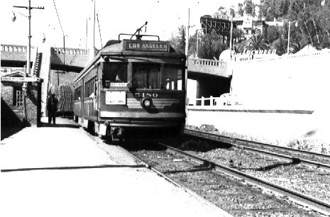
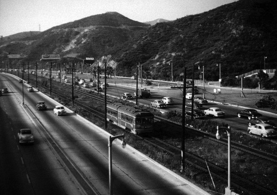
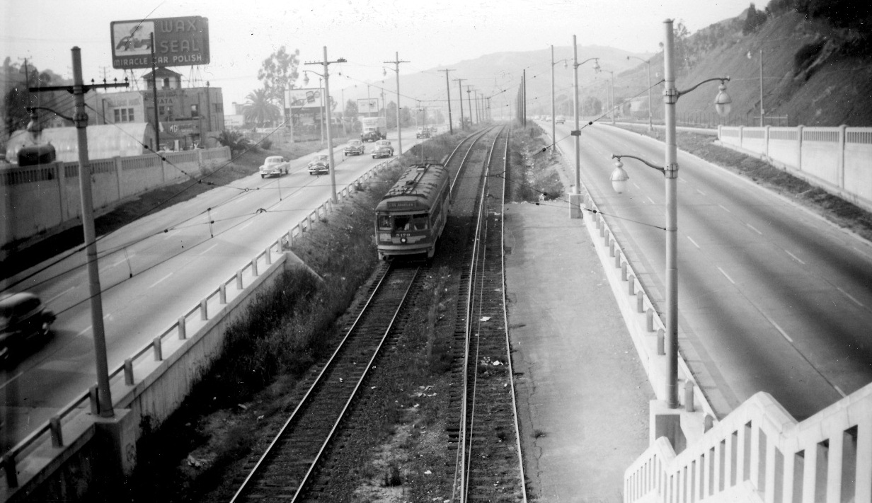
| (1940)++^ – View showing the Cahuenga Pass Freeway looking southwest toward Hollywood with the Mulholland Drive overcrossing at center. The Pacific Electric Railway tracks are visible in the median. |
Historical Notes The first segment of the Hollywood Freeway built was a one and a half mile stretch through the Cahuenga Pass. That segment opened on June 15, 1940. It was then known as the "Cahuenga Pass Freeway." Pacific Electric Railway trolleys ran down the center of this freeway until 1952.*^ |
 |
|
| (1943)^^ - View of Cahuenga Pass with light traffic on February 16, 1943. Note the Pacific Eletric tracks. |
 |
|
| (1947)*^#* – Postcard view showing the Cahuenga Pass Freeway (later Hollywood Freeway), the “Gateway to Hollywood", with Mulholland Drive winding up into the Hollywood Hills in the upper-right. |
 |
|
| (1947)##^* - View of Cahuenga Pass looking towards Hollywood at the Mulholland Bridge. |
 |
|
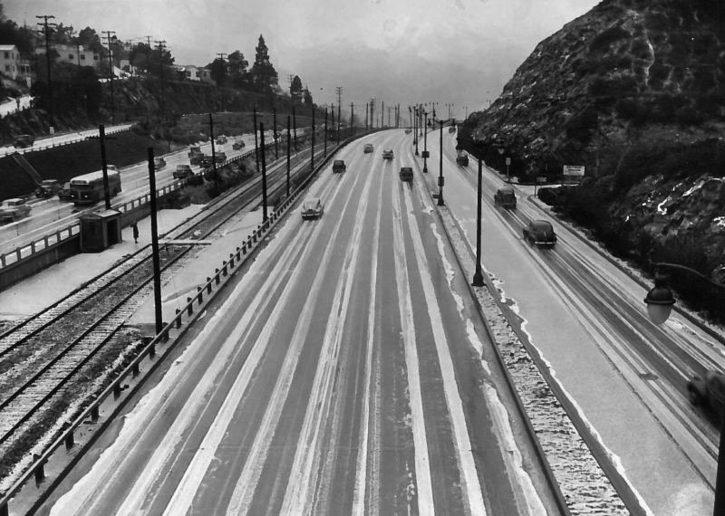
| (1948)^^ - View looking toward the San Fernando Valley showing a rare sight - freshly fallen snow in Cahuenga Pass. |
Historical Notes Snow is a rare occurrence in the Los Angeles Basin. While it's common in the region's mountains, the moderating effect of the Pacific means that at lower elevations temperatures rarely fall below the point necessary to create snow. Since records were first kept in 1921, snow has fallen on downtown Los Angeles only ten times—and not once since 1962. |
 |
|
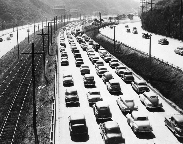
| (1948)* - View of Cahuenga Pass showing one road of cars end to end heading into the City from the San Fernando Valley during rush hour traffic. Note the Pacific Red Car tracks at left. |
 |
|
| (1948)#**# - View looking southeast showing Pacific Red Car, tracks, and station at center of Cahuenga Pass. |
Historical Notes The view above is from the top of Barham Bridge which at the time had a stairway running down to the tracks. |
 |
(ca. 1948)++^ - View looking northwest showing a Pacific Red Car stopped at the Barham Station with the Barham Bridge in the background.
|
Then and Now
|
|
 |
|
| (1948)#**# - (2015)*### - View looking southeast from the top of Barham Bridge in Caheunga Pass. |
.jpg) |
|
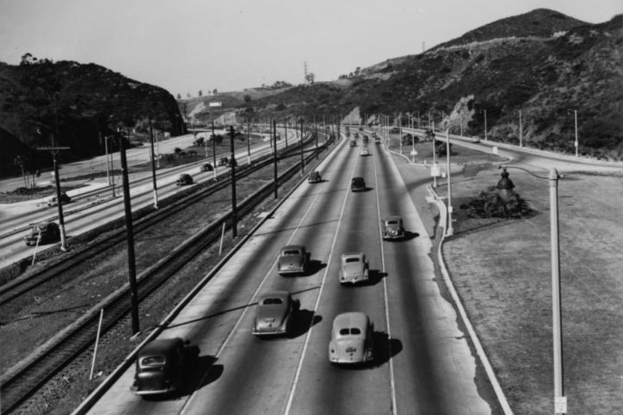
| (1949)* - Early morning view of Cahenga Pass as cars head into Hollywood and metropolitan Los Angeles from the San Fernando Valley. |
 |
|
| (1949)* - View of the roads, rail lines, and cars traveling through the Cahuenga Pass, the most important section of the Hollywood Freeway, which is the "gateway" that opens fast traffic from the San Fernando Valley into Hollywood and the heart of metropolitan Los Angeles. The short city-built Cahuenga Pass Freeway was opened on June 15, 1940. |
 |
|
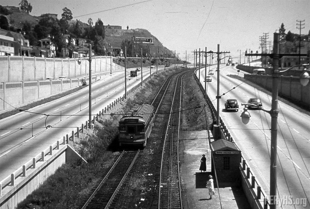
| (ca. 1950)^#^^ - A Pacific Red Car returning from the San Fernando Valley travels along the Cahuenga Pass toward Hollywood. |
 |
|
| (1952)^^ - View of Cahuenga Pass during rush hour traffic on a rainy morning. |
| (1952)##^* – View of the Lankershim Boulevard underpass at the Hollywood Freeway, showing two Pacific Electric Red Cars passing each other above. |
 |
|
| (1952)*^# - A Pacific Electric Red Car headed south in the median of the Hollywood Freeway near Barham. |
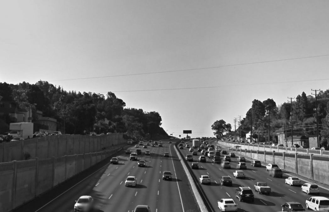
Historical Notes 1952 was the last year Pacific Electric Railway trolleys ran down the center of the "Cahuenga Pass Freeway", (Hollywood Freeway).*^ |
Click HERE to see more Early Views of Cahuenga Pass |
Hollywood Freeway
 |
|
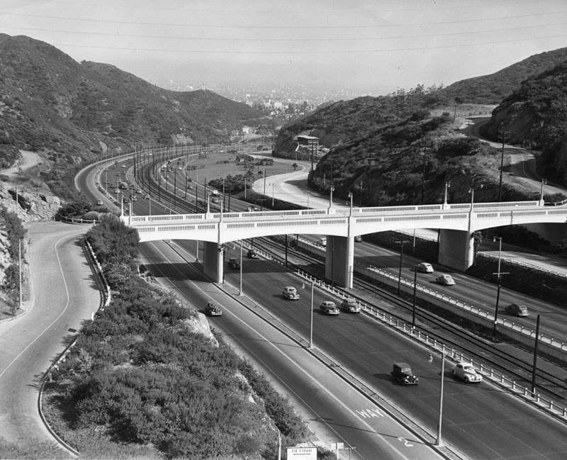
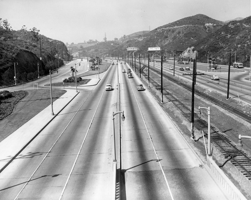
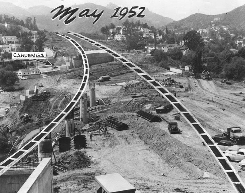
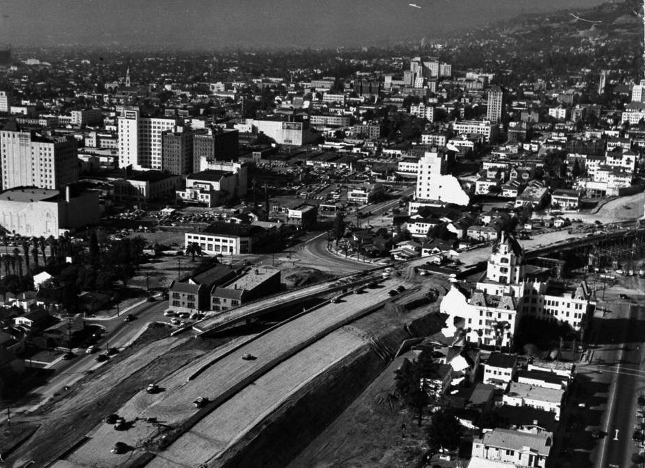
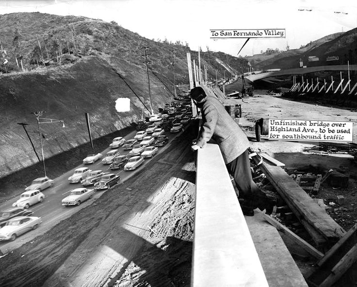
| (1952)* - This scene is just two blocks north of the famous intersection of Hollywood and Vine, the "Heart of Hollywood." Steel reinforced columns jutting from the hillside will soon support new, wide ribbons of concrete approaching Cahuenga Boulevard. Freeway will be a boon to Valley motorists who use Cahuenga Pass. Click HERE to see more in Early Views of the San Fernando Valley. |
 |
|
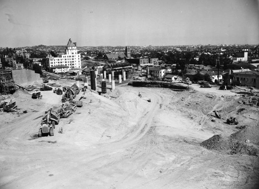
| (1952)*# - Looking southeast towards a new bridge over Cahuenga Boulevard during the construction of the Hollywood Freeway with the Hollywood Tower in the background. |
 |
|
| (1953)^*^# – View showing the construction of the 101 Freeway through Hollywood at Argyle Avenue. The intersection of Yucca Street and Argyle Avenue is at lower-left. You can see the Castle Argyle and the Hollywood Tower at right. Source: Life Magazine |
 |
|
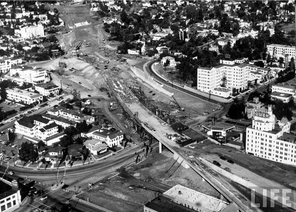
| (1953)*# – Aerial view looking west showing the construction of the Hollywood Freeway through Hollywood. The intersection of Argyle and Yucca is at the center of the photo and the Hollywood Tower is in the foreground on the right. Source: Life Magazine. Click HERE to see GOOGLE EARTH contemporary view. |
 |
|
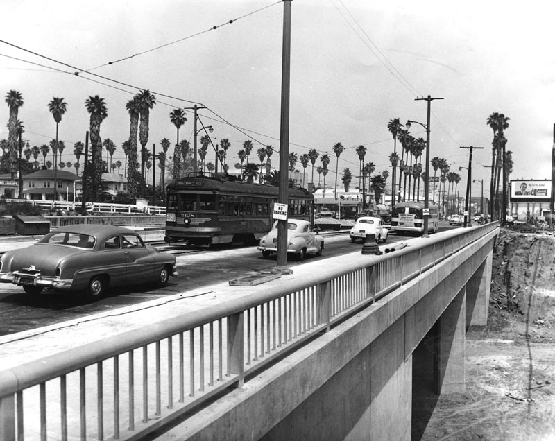
| (1952)* - Eastbound streetcar and motor traffic uses the new Hollywood Boulevard bridge spanning the yet to be completed Hollywood Freeway near Bronson Avenue. |
 |
|
| (1953)* - View, looking north, showing the construction progress of the Hollywood Freeway through Cahuenga Pass. |
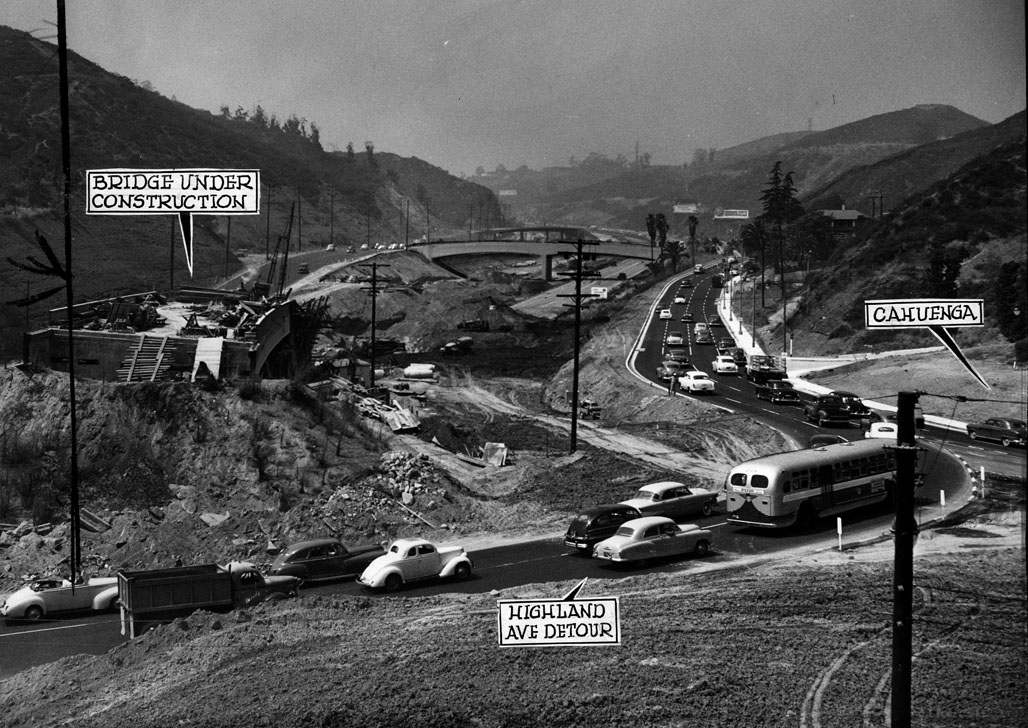 |
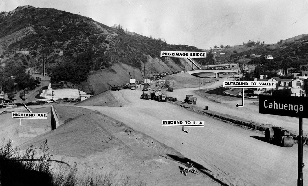
|
| (1953)* - View of Cahuenga Pass. All Highland Avenue detour traffic now pours into Cahuenga Boulevard while work continues on the northerly links of the Hollywood Freeway. The new link, of course, also discharges its travelers onto Cahuenga. |
Historical Notes The second section of the Hollywood Freeway that stretched from the San Fernando Valley to Downtown Los Angeles opened on April 16, 1954 at a cost of $55 million.*^ |
 |
|
| (1954)* - The 101 appears to be open, but the bridge over Highland Avenue is still under construction in January 1954. |
 |
|
| (1954)* - View looking north at Cahuenga Boulevarfd in front of the Hollywood Bowl, shortly before the second segment of the Hollywood Freeway was completed. Automobiles are backed, bumper to bumper for miles, as the final stages of construction wrap up. |
 |
|
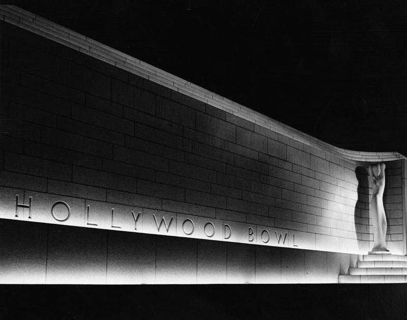
| (1940)* - Night view of the statue and sign at the Hollywood Bowl entrance on July 10, 1940. |
Click HERE to see more in Early Views of the Hollywood Bowl |
 |
|
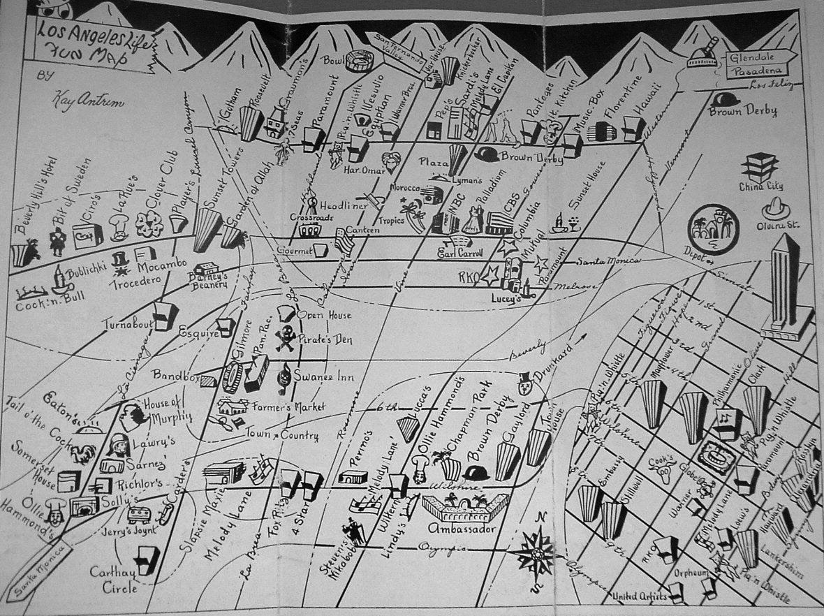
| (1945)*# - "Los Angeles Life Fun Map" distributed by Santa Fe Bus Lines and the Glass House Restaurant. Map highlights all the must see places in Los Angeles during the 1940s (i.e. Hollywood Bowl at very top of photo and also the Pantages Theatre at top right-center). |
* * * * * |
Please Support Our CauseWater and Power Associates, Inc. is a non-profit, public service organization dedicated to preserving historical records and photos. Your generosity allows us to continue to disseminate knowledge of the rich and diverse multicultural history of the greater Los Angeles area; to serve as a resource of historical information; and to assist in the preservation of the city's historic records.
|
More Historical Early Views
Newest Additions
Early LA Buildings and City Views
History of Water and Electricity in Los Angeles
* * * * * |
References and Credits
* LA Public Library Image Archive
^*California Historic Landmark Listing (Los Angeles)
^ California Historical Society Digital Archive
** Retronaut - Hollywoodland Sign
#* Pinterest - California and DailyBreeze.com; Mid Century Hollywood; Been There: Hollywod Sign
*^#LosAngelesPast.com: Cahuenga Pass
^^#LA Times: 'Swing in, pig out, drive off'; Hollywood Bond Cavalcade; Sunset Vine Tower; Taft Building; Pickwick Bookshop
***The Story of Hollywood by Gregory Paul Williams
**^Table Magazine: LA Observatory
**+Hollywood Renegades Archive: "The Lot"
**#Beguiling Hollywood: The Hollywood Hotel
^**Huntington Digital Library Archive
*^*MTA Transportation and Research Library Archives
*.* Greater Streets: Exploring the Walk of Fame — Heart of Hollywood
^^*Cinema Treasures:Ricardo Montabaln Theater
^^^California State Library Image Archive
^+^Cool Culinaria: Restaurateur Mike Lyman
+^*Jewish Museum of the American West: Restaurateur Al Levy
+^^Don Lee Mutual Broadcasting Building
++#Facebook.com: Photos of Los Angeles
*^^*Photos of Vintage Los Angeles: Facebook.com; Palladium; Capitol Records; Cruising Hollywood Blvd; Masonic Temple; Hody's Coffee Shop
*^#*Calisphere: University of California Image Archive
*^*#Pinterest.com: Favorite Places and Spaces
**^*LA Daily News: Hollywood Sign Celebrates its 90th Birthday
***#Art Deco Architecture: LA Radio City
**##MartinTurnbull: Cross Roads of the World; Biff's Coffee Shop
^^##Alison Martino's Vintage Los Angeles: Wallichs Music City
++##Grauman's Chinese.org: Academy Awards
*#^^Flickr.com - Daniel Pouliot
*##*Squidoo.com: Lawrence Welk
*##^The Daily Meal: Formosa Cafe
^##*Flickr.com: Michael Ryerson; Baytram366; Melody Lane
^###Uncanny.net: Hollywood Pacific Electric Line
^#*#Bellaonline.com: Mickey Rooney and Judy Garland
^#^*Flickr.com: Los Angeles - Back in the Day
^#^^Facebook.com - Vintage LA: Hollywood Palladium; Hollywood and Gower; Hollywood and Vine; Sunset & Vine; Capitol Records Building; United Methodist Church; Hollywood Ranch Market; Wallich's Music City; Tiny Naylors
^^#^History of the Samuel Goldwyn Studio
^^^#KCET's First Hollywood Home: The Historic Mutual-Don Lee Studios
#^**The Go Go's: Local Coffee Shops and Diners
^*#*Pinterest - Memories in the SFV 50's, 60's, & 70's
^*##Vintage Inspired California - marinachetner.com
^*^^Pomona Public Library Poscard Collection
^*^#Facebook.com - Bizarre Los Angeles
#**^Starlinetours.com: TLC Chinese Theatre
#**#Facebook.com: Garden of Allah Novels, Martin Turnbull
#*^#Historic Hollywood Theatres: Warner Bros. Hollywood Theatre
#^*#TheHollywoodMuseum.com: Max Factor Building
#^**The Go Go's: N/W Corner of Hollywood and Vine
#^^^Once Upon a Screen: Hollywood Canteen
#^#^Groceteria.com: A&P History
##**The Story of the Hollywood Sign: allanellenberger.com
##*^The Hollywood Sign: hollywoodsign.org
##*#Flickr.com: Paul Bajerczak
#*##Electric Railway Historic Association: Hollywood PE Line
+###Dear Old Hollywood Blogspot
##^*Facebook.com: Classic Hollywood-Los Angeles-SFV
##^^halfcoastal.com: The Hollywood Sign
***^Pinterest: Travel The World: 'HOLLYWEED'; Los Angeles and Hollywood
*^^ Nuestra Señora la Reina de los Ángeles: Vogue Theater; Hollywood Blvd Night 1930s; Hollywood and Vine ca.56
*^*^#Facebook.com: West San Fernando Valley Then And Now
^^***Pinterest: Diners
^^*^*Los Angeles Magazine: Capitol Records Building Christmas
^^*^^sittininthehills64.blogspot.com: Hollywood Views
*^^**Blogspot.com: Hollywood HoJo
*^#^*Vintage Everyday
^#^#^LA Curbed: Al Levy's Tavern
^###^Flickr.com: timetravelnow
*# Skyscraperage.com. - Griffith Observatory; CBS West Coast Headquarters; LA Fun Map; NBC Hollywood Radio City; Cross Roads of the World; Hollywood and Vine; Orchid Ave and Hollywood Blvd; Max Factor Building; Cahuenga and Yucca St.; Vine and Sunset; Tiny Naylors; Hollywood Frwy Construction at Argyle
*^ Wikipedia: Hollywood; Hollywood Athletic Club; Hollywood Bowl; Grauman's Chinese Theatre; Grauman's Egyptian Theatre; Pantages Theatre (Hollywood); John Hanson Ford Theatre; 20th Century Fox; Samuel Goldwyn.Studio; Barnsdall Art Park; Greek Theatre; Griffith Observatory; Cinerama Dome; Ralphs; Hollywood Palladium; Hollywood and Vine; Hollywood Masonic Temple; Hollywood Pacific Theatre; Max Factor; West Hollywood; Brown Derby; Hollywood Christmas Parade; Tom Breneman; Schwab's Pharmacy; Capitol Records Building; CBS Columbia Square; West Coast Radio City - Los Angeles; Crossroads of the World; Hollywood Sign; Lawrence Welk; Du-Par's Restaurant; Formosa Cafe; Hollywood Walk of Fame; Marilyn Monroe; John C. Austin; KFWB; The Beatles at the Hollywood Bowl; 2005 Hollywood Sign; Rexall - Owl Drug Store; Hollywood Canteen; KABC; Wallichs Music City; Thrifty Drug Stores; Lasky-DeMille Barn; Mt. Lee; The Wizard of Oz ; Hollywood Roosevelt Hotel; Eddie Cochran; Guarantee Building; Hollywood United Methodist Church; Carolina Pines, Jr.; Vista Theatre
< Back