Early Views of Bunker Hill |
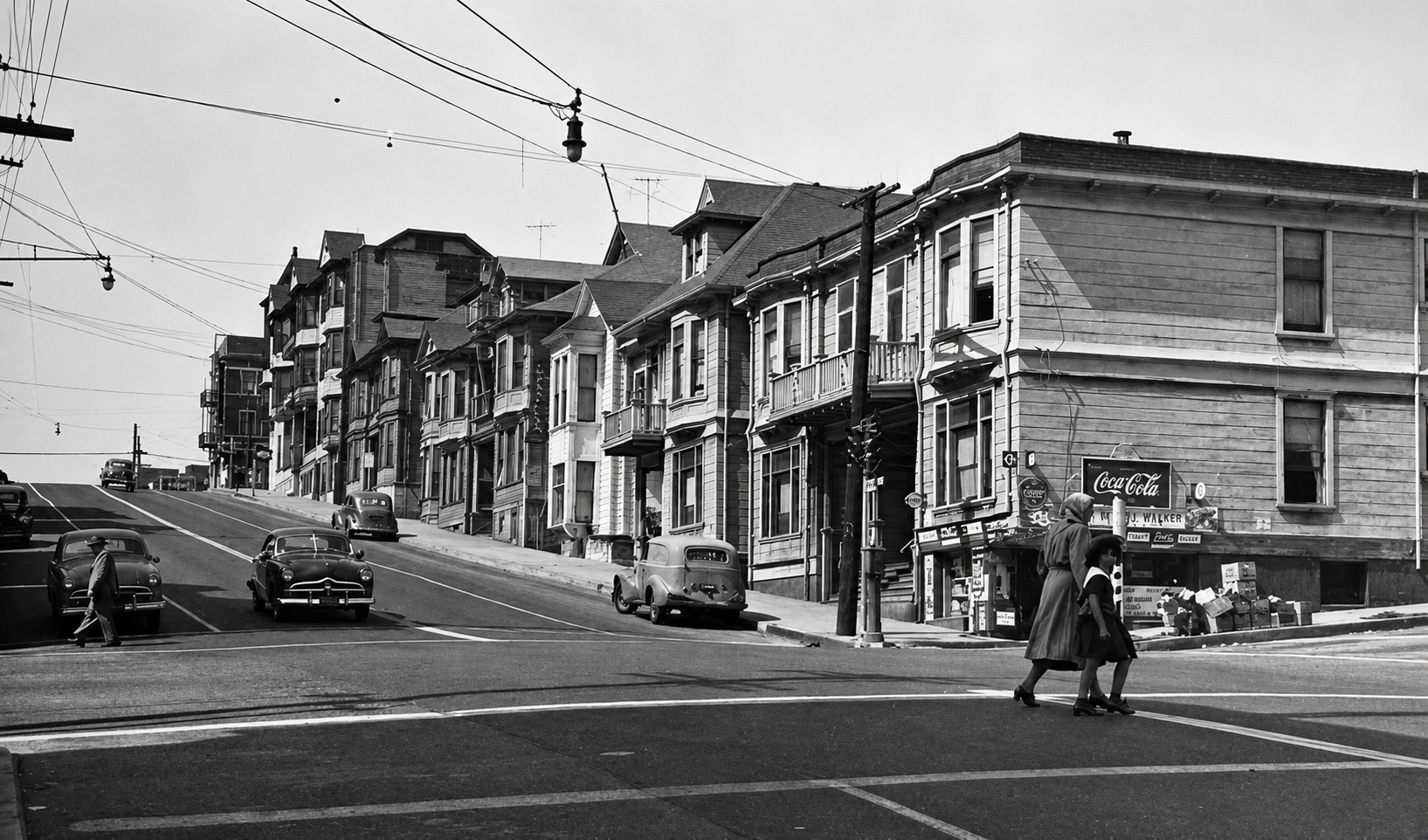
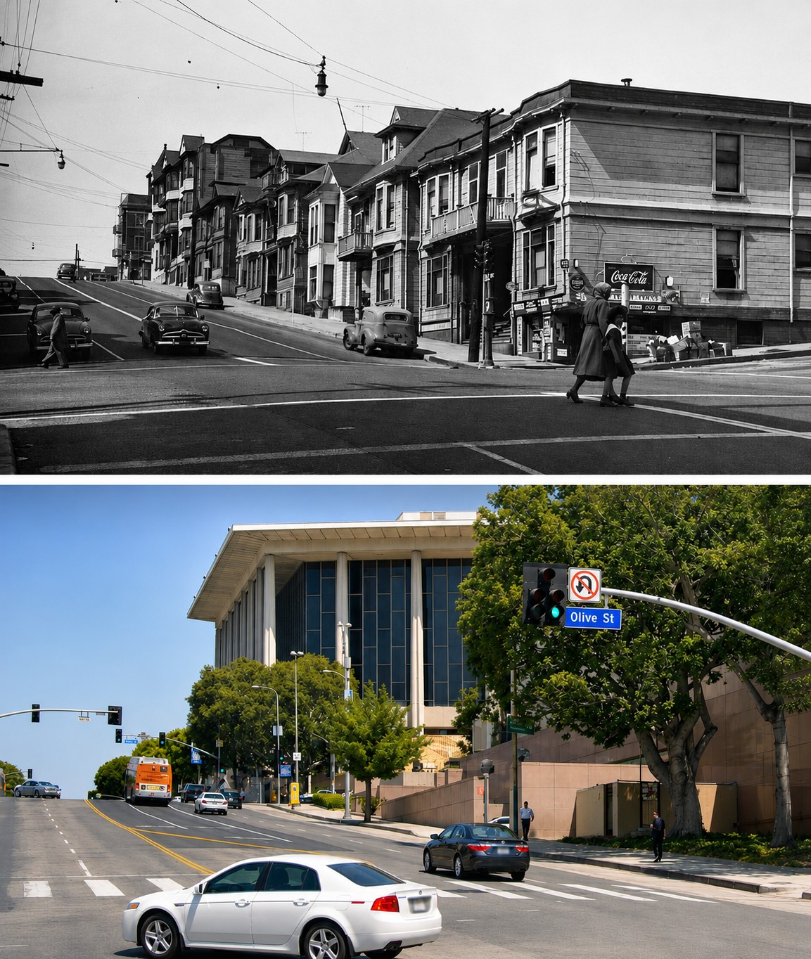
A Neighborhood Transformed |
(1930s to Present) |
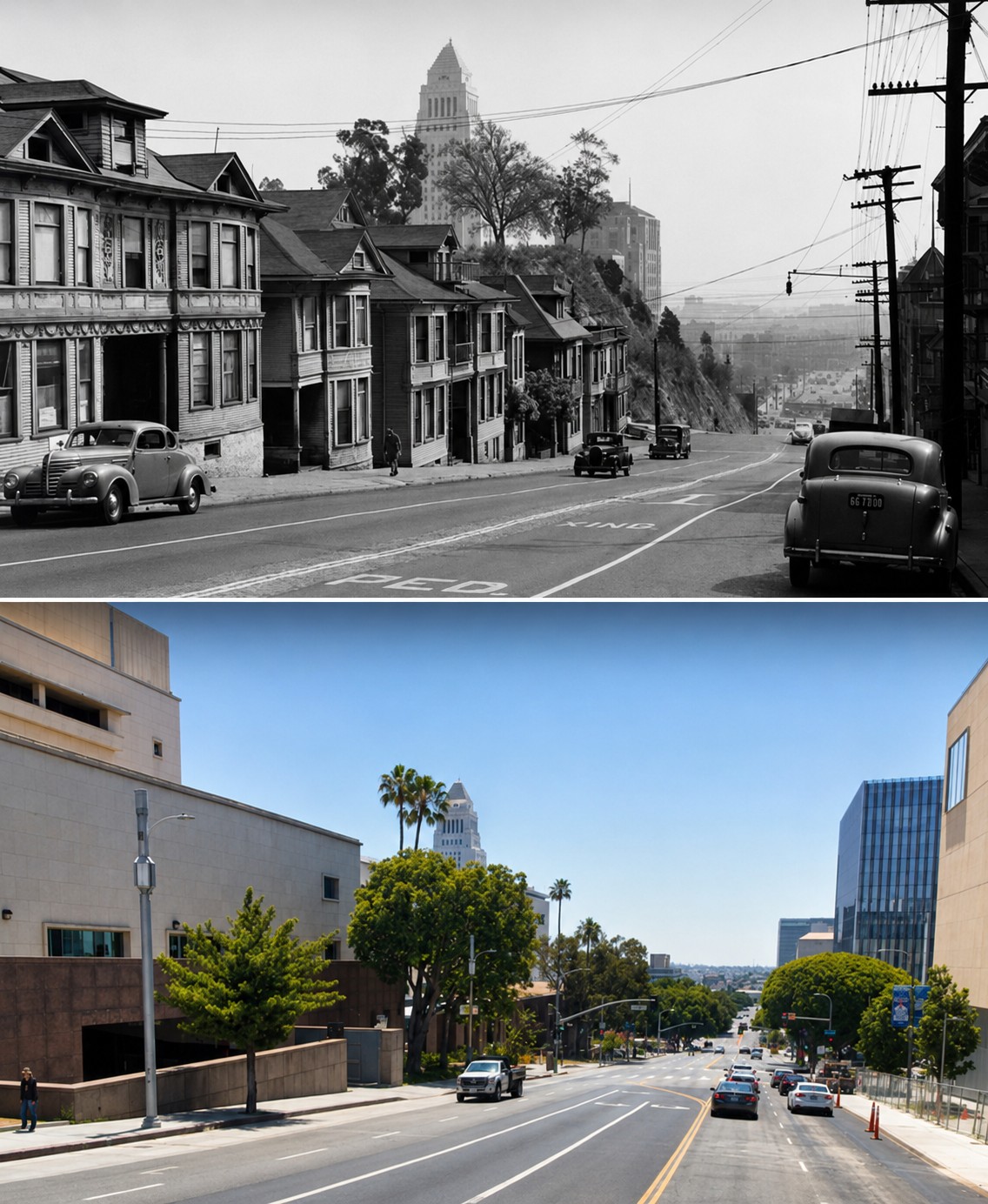
Bunker Hill was once one of Los Angeles’ most distinctive neighborhoods. Rising just west of the Civic Center, the hill was lined with Victorian homes, small hotels, and apartment houses that reflected the city’s growth in the late 19th and early 20th centuries. By the 1930s and 1940s, many of these buildings had been subdivided into rooming houses, creating a dense working class community.By the late 1950s, that landscape was being cleared as part of a major redevelopment effort. Entire blocks were demolished, the hill was graded down, and the street grid was reconfigured to make way for freeways, civic buildings, and cultural institutions. What had developed over decades was replaced within a relatively short period.These images trace that transformation across nearly a century. From early aerial views and street level scenes to modern comparisons, they show how Bunker Hill evolved from a residential neighborhood into the civic and cultural center of downtown Los Angeles. Together, these views document the physical transformation of Bunker Hill over time. |
.jpg) |
|
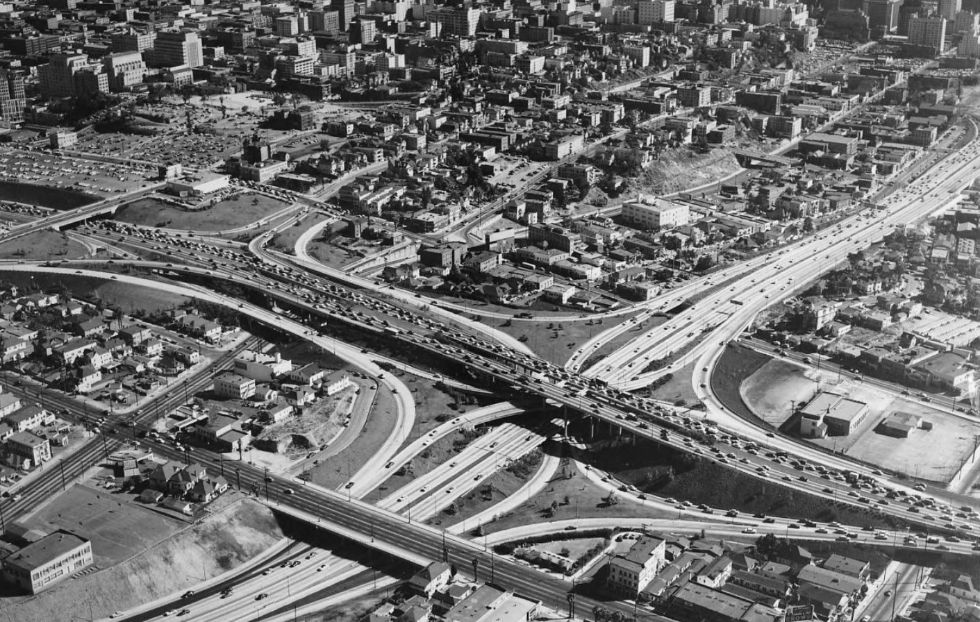
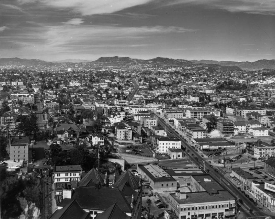
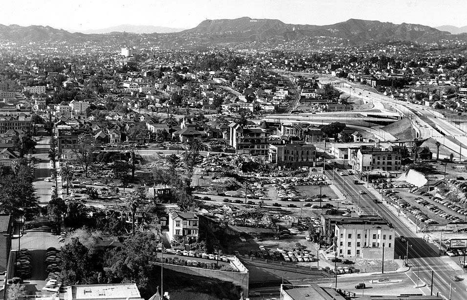
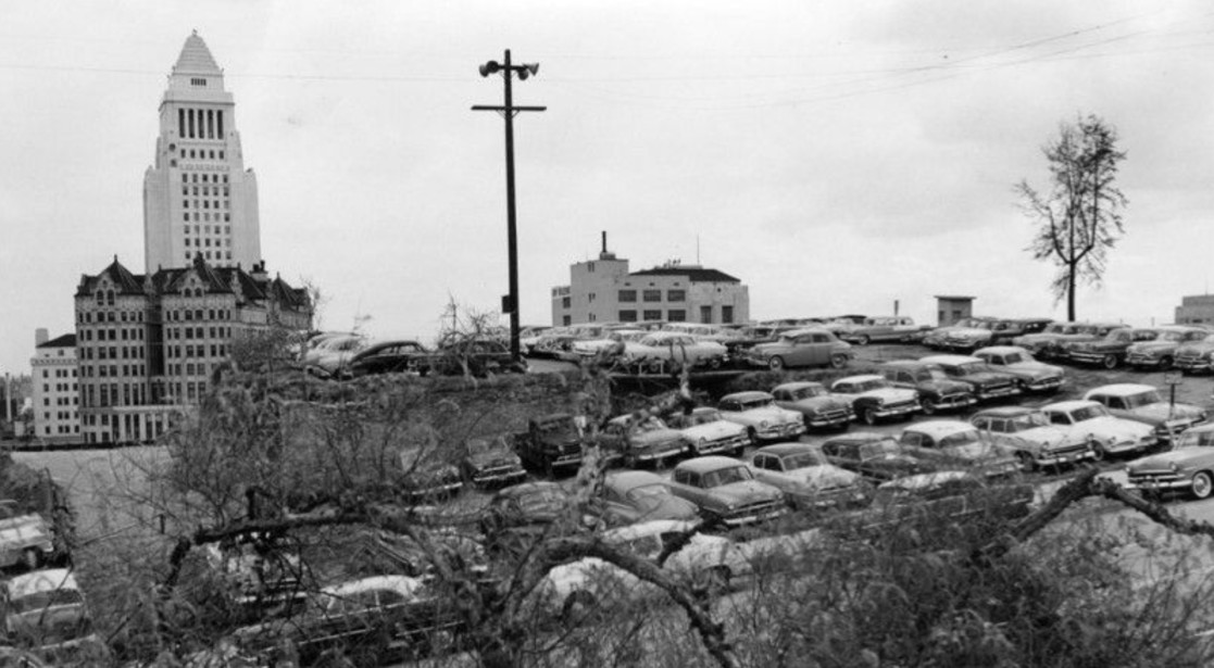
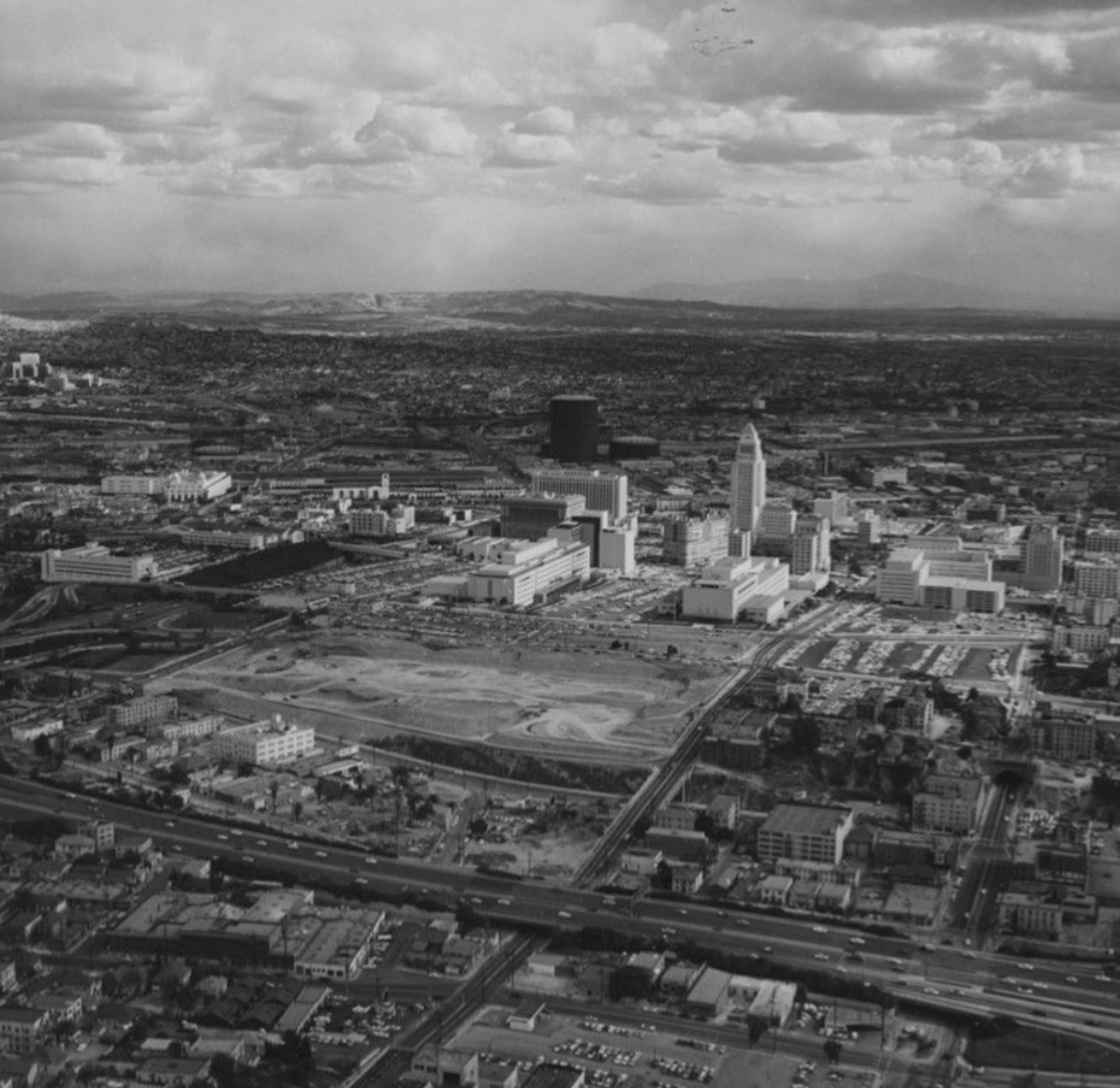
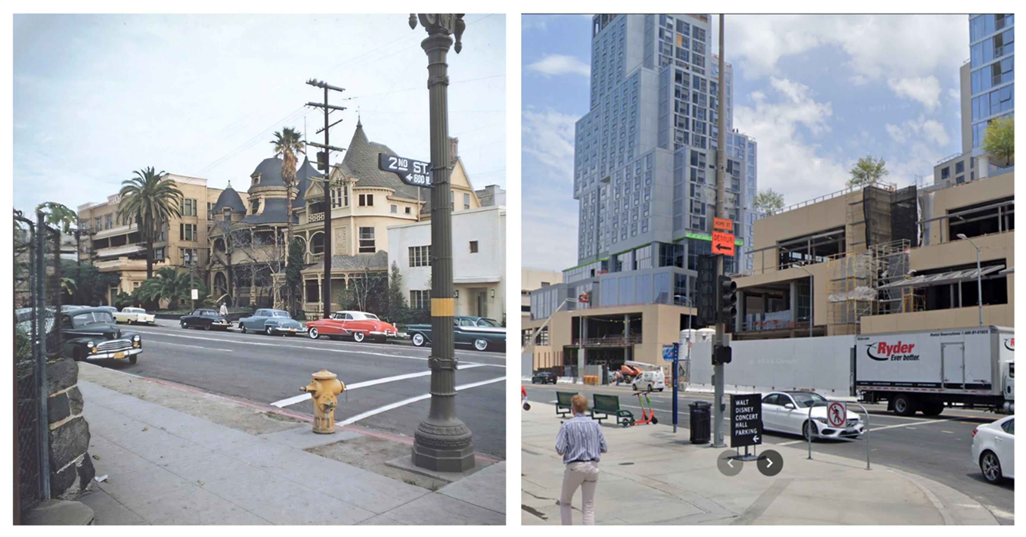
| (ca. 1938)* - Aerial view of Bunker Hill and the Civic Center looking east. City Hall was the tallest building in Los Angeles for decades. Photo by Dick Whittington |
| Historical Notes
By the late 1930s, Bunker Hill was one of the most densely built neighborhoods near downtown Los Angeles. From above, the hill looks like a patchwork of closely spaced houses, small apartment buildings, and narrow streets that grew up over decades with no central plan. City Hall, completed in 1928, rises clearly in the distance. It shows the sharp contrast between the city's growing civic center and the older neighborhood just to the west. |
 |
|
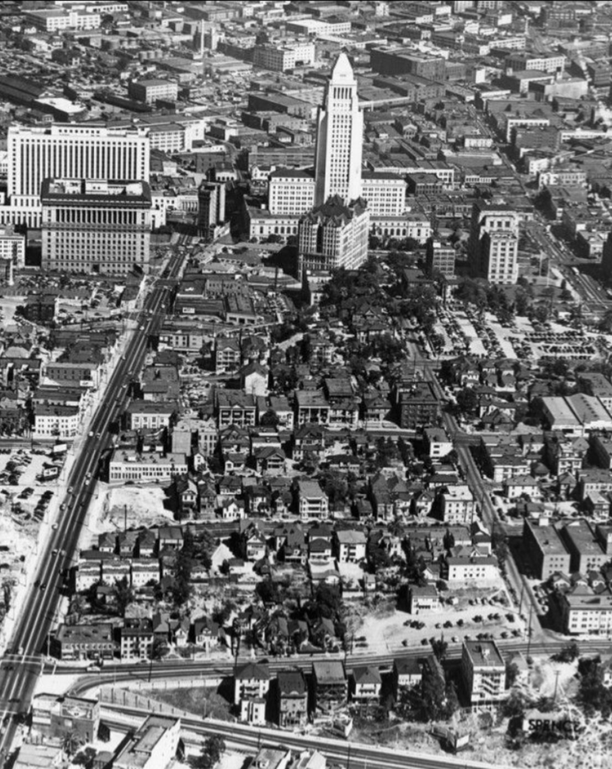
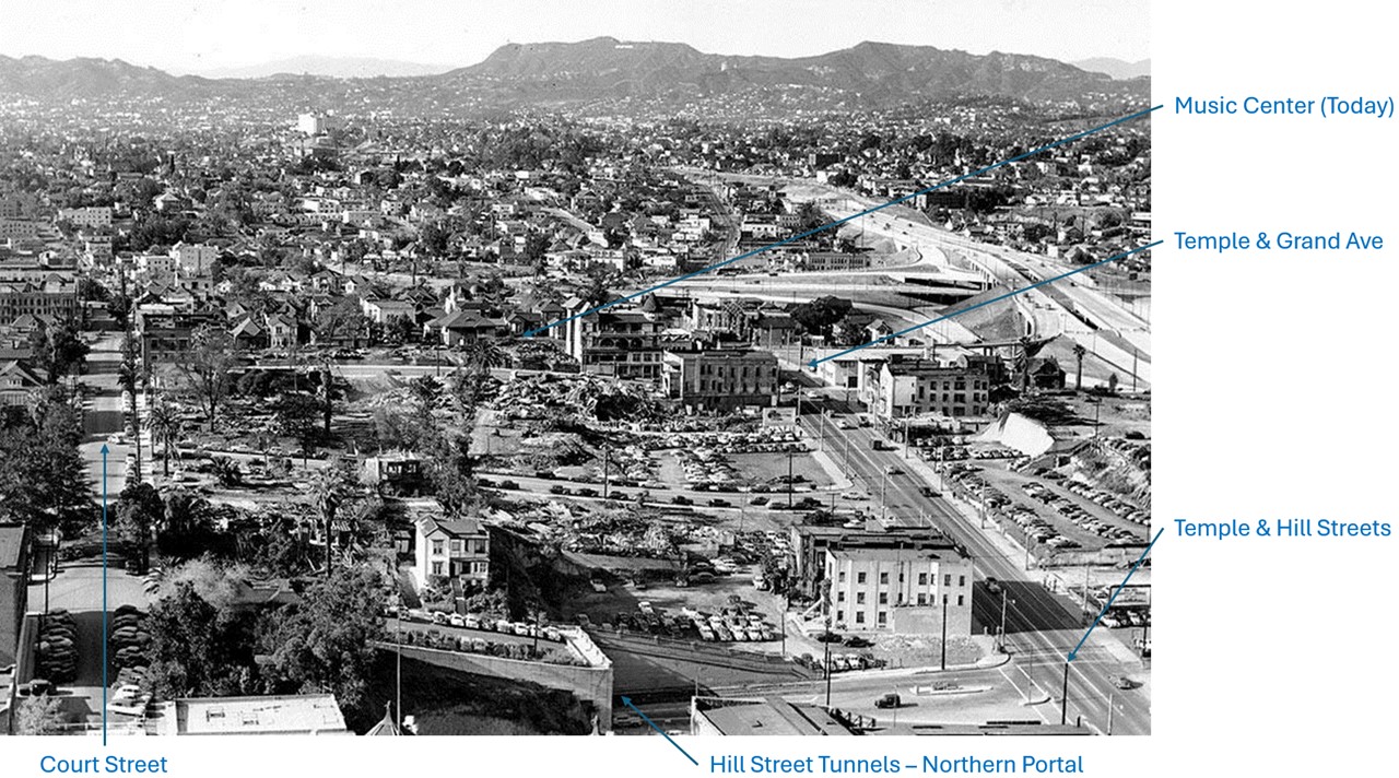
| (ca. 1938)* – Aerial view looking east over Bunker Hill toward City Hall, annotated with street names. |
| Historical Notes
In 1945, California passed a law giving cities the power to buy and clear areas they labeled as blighted. In the years that followed, Bunker Hill became the first major project of the Los Angeles Community Redevelopment Agency. By the early 1950s, planning was already underway. Officials pointed to overcrowding, aging housing, and safety concerns to make their case. These decisions started the large scale clearance that would soon reshape the hill. |
 |
|
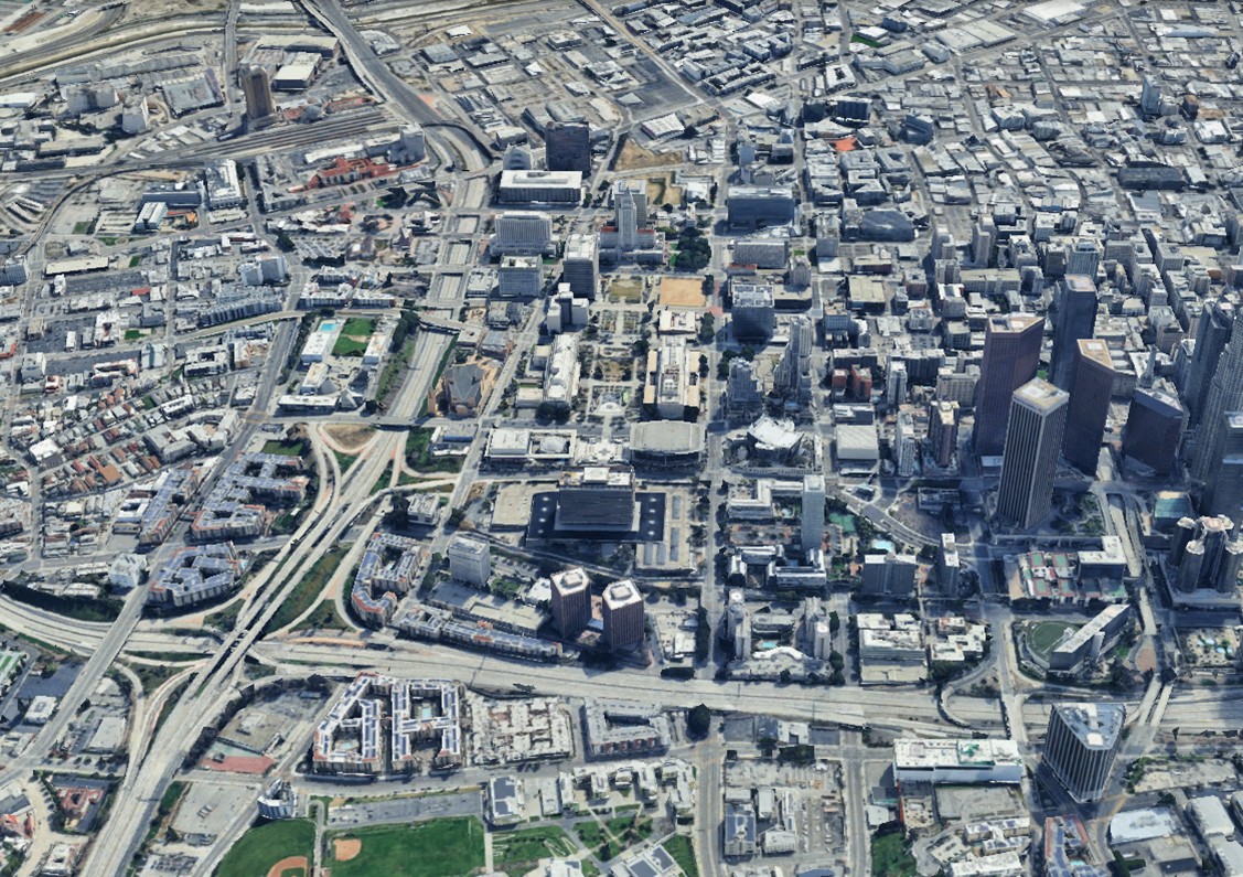
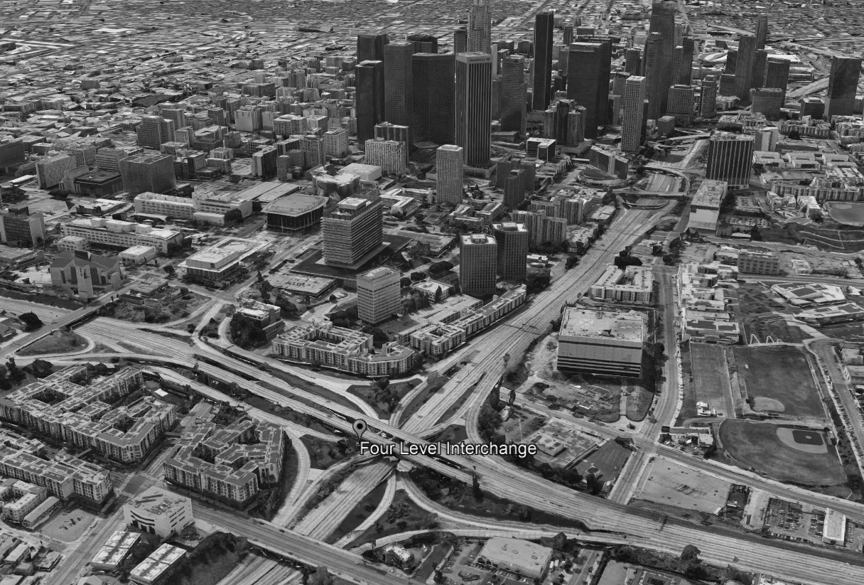
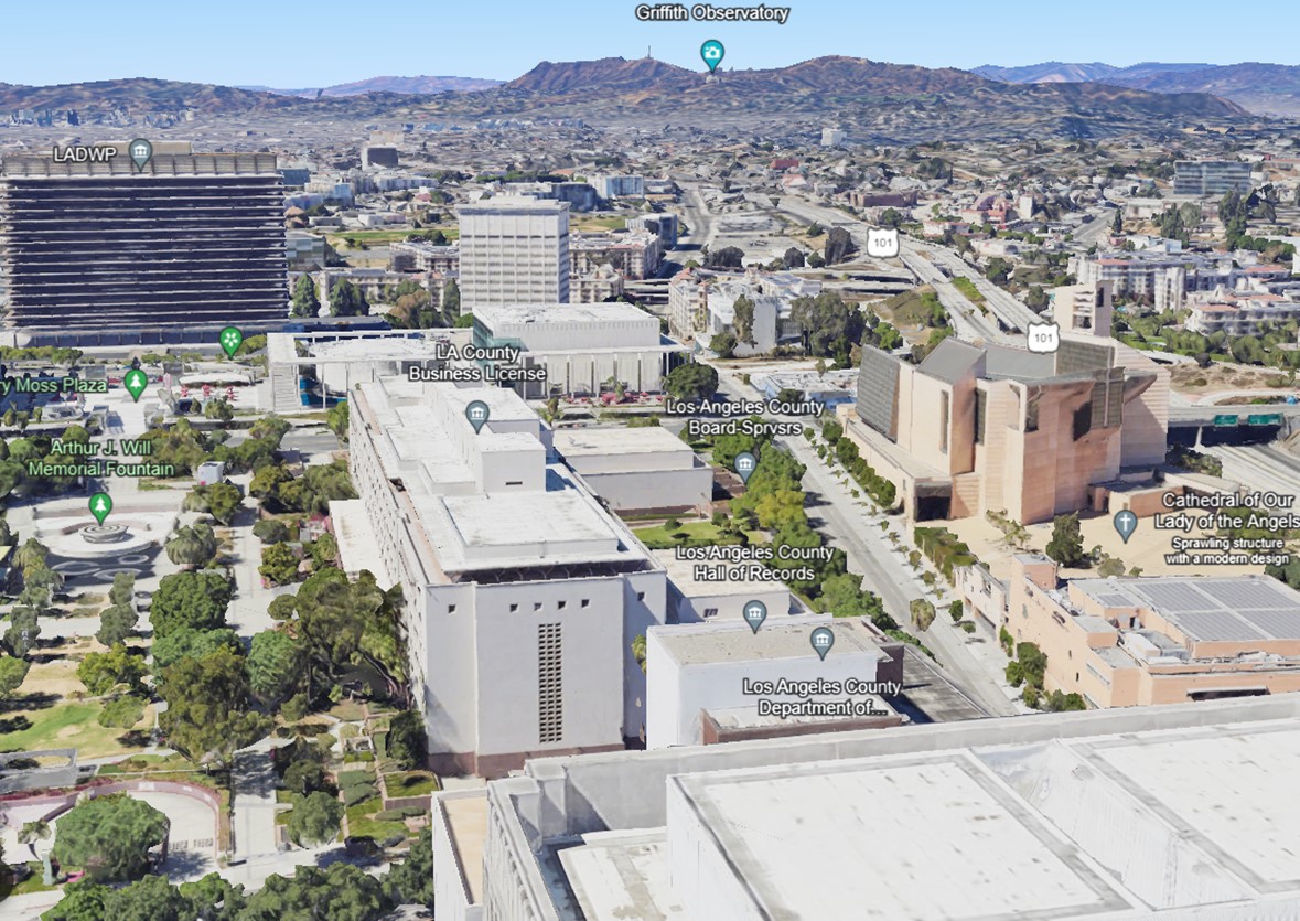
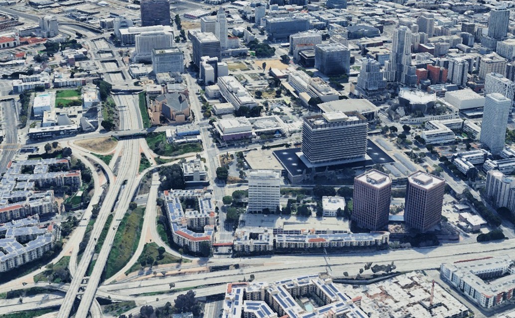
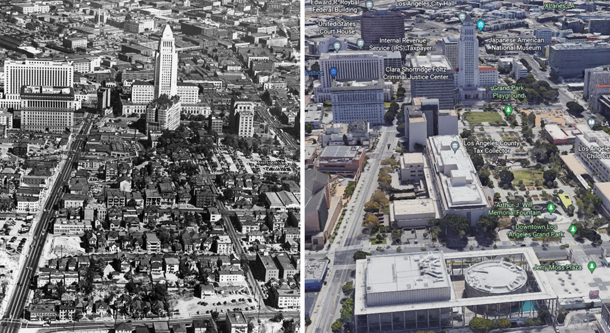
| (2023)* - Google Earth view showing the Civic Center and Bunker Hill as it looks today. |
| Historical Notes
Today, the landscape looks almost nothing like the earlier views. Bunker Hill is now home to office towers, cultural institutions such as the Walt Disney Concert Hall and The Broad, and a street network rebuilt for modern development. What was once a continuous residential neighborhood has been replaced by a district shaped by civic planning and large scale investment. |
Then and Now
 |
|
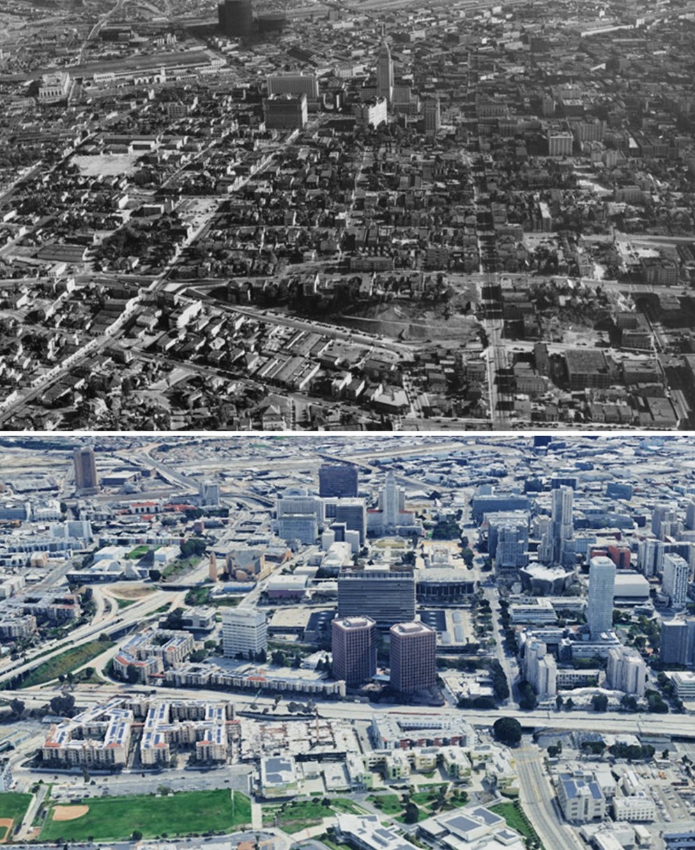
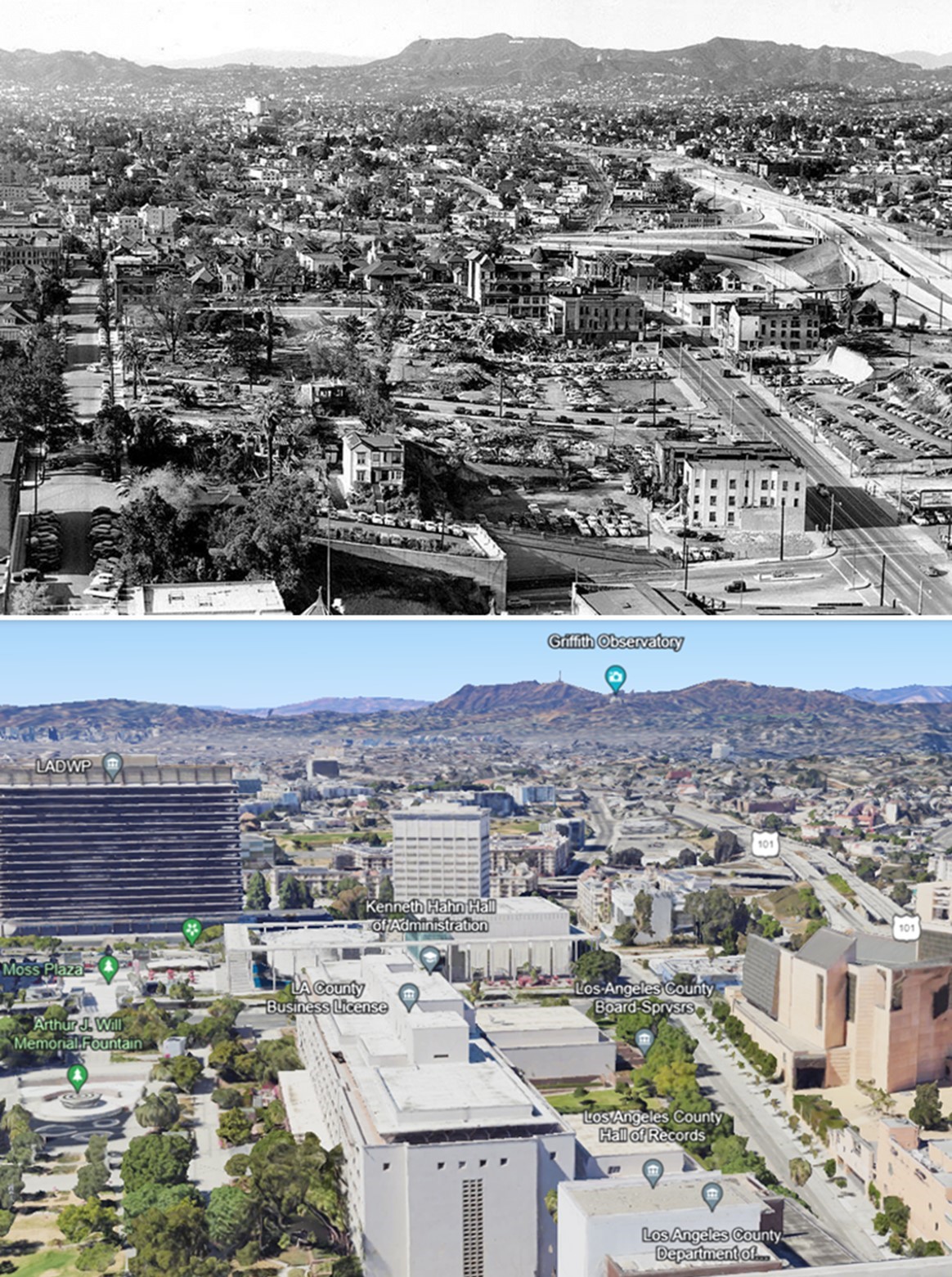
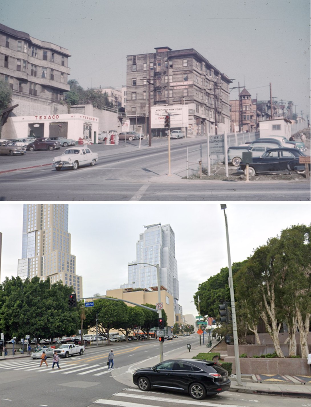
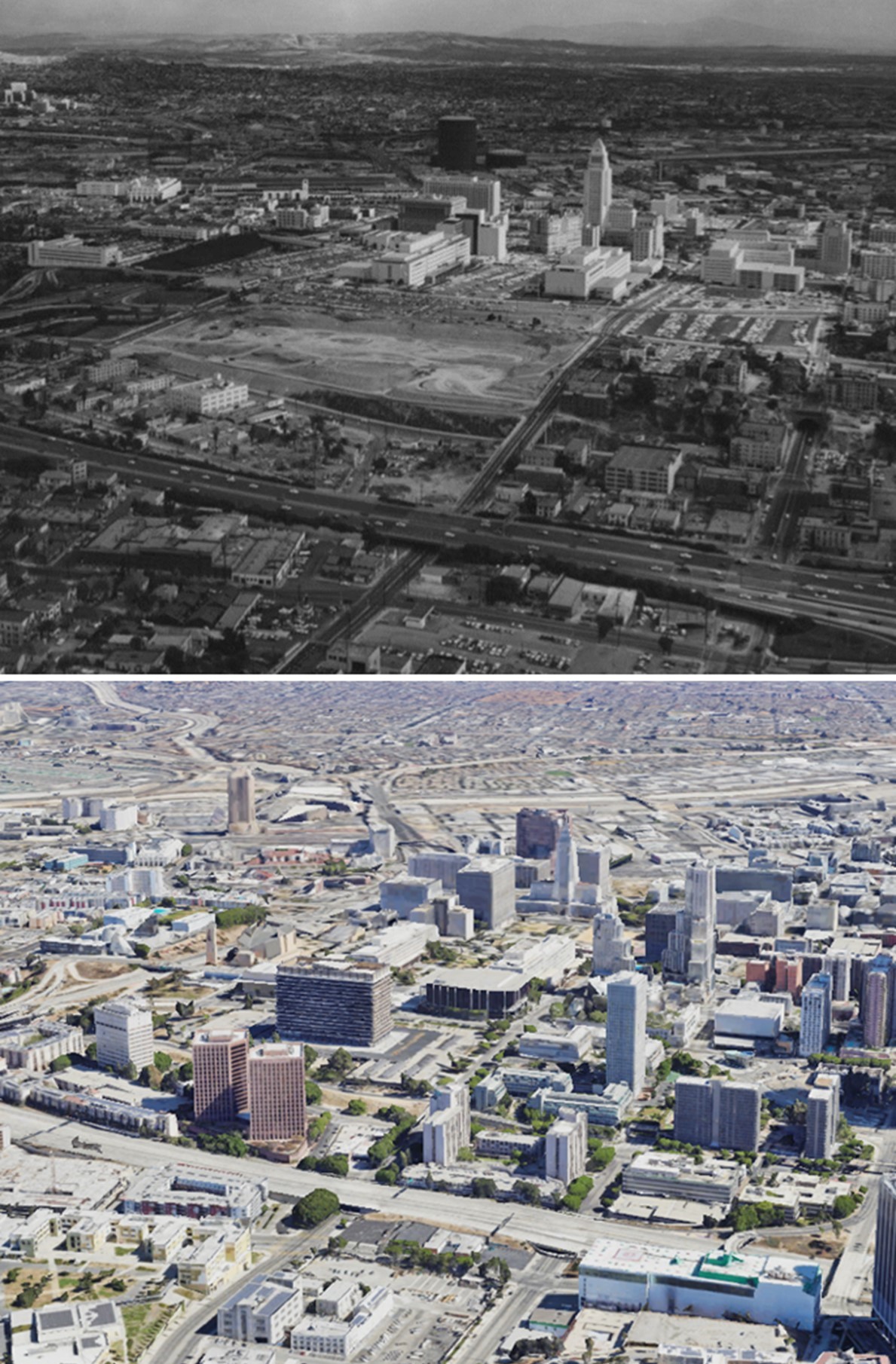
| (1938 vs 2023)* - Then and Now - Photo comparison by Jack Feldman. |
| Historical Notes
This comparison shows just how much changed over nearly a century. The 1938 photo shows a hillside covered with houses, small apartments, and narrow streets. The 2023 view shows what replaced it. Towering office buildings, wide boulevards, and civic landmarks now occupy land that was once a living neighborhood. |
Then and Now (Annotated)
 |
|
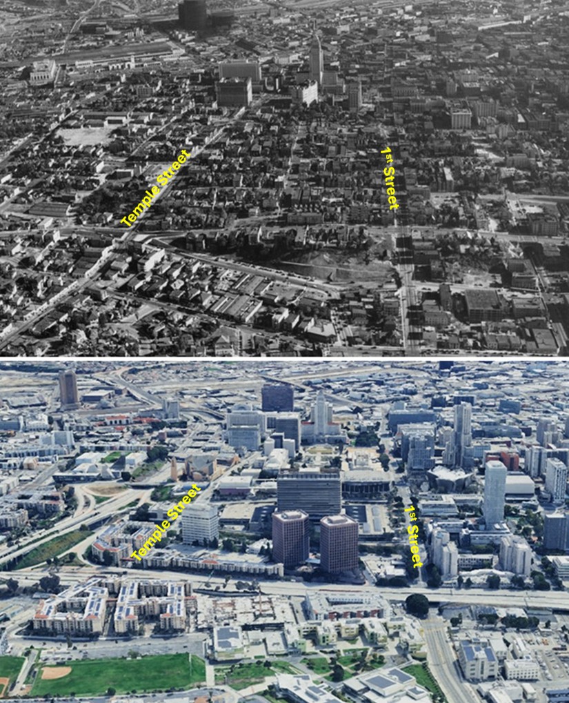
| (1938 vs 2023)* - Then and Now - Photo comparison by Jack Feldman. |
| Historical Notes
The annotated version helps identify exactly where streets and landmarks once stood before redevelopment removed them. Familiar names like Temple, Grand, and Figueroa are still there, but everything around them has changed. The street names stayed the same while the neighborhood they ran through was completely erased. |
* * * * * |
Bunker Hill Redevelopment: Music Center and DWP Building |
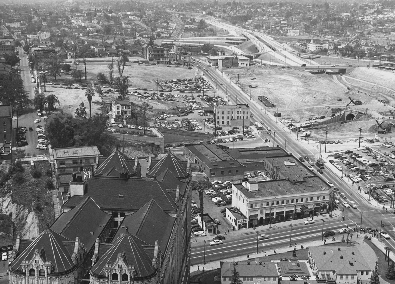
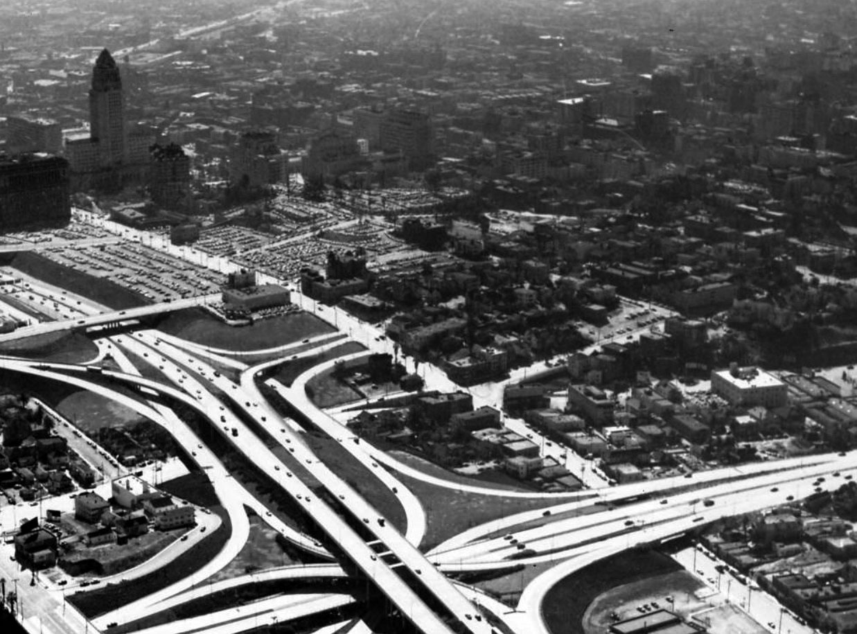
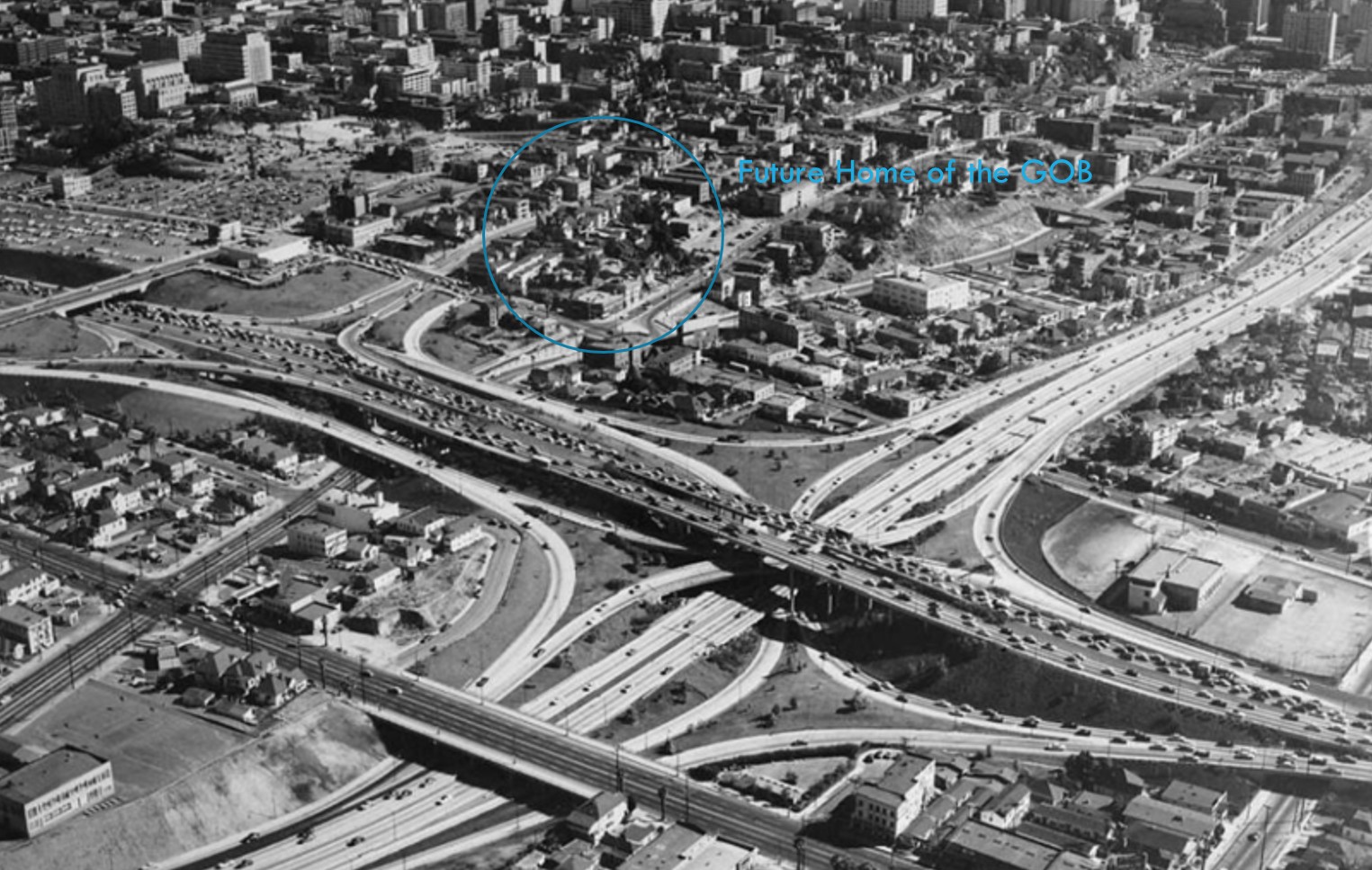
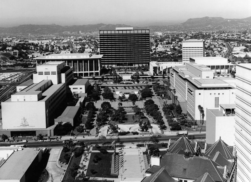
By the late 1950s, Los Angeles made a decision that would change downtown. Bunker Hill, a dense neighborhood of Victorian homes, small hotels, and rooming houses, was slated for demolition. In its place, the city planned a new civic and cultural center.At the heart of that plan were two major projects. The Department of Water and Power’s General Office Building, later renamed the John Ferraro Building, and the Music Center would anchor a new downtown built around government and cultural institutions.The images in this section capture that moment. They show Bunker Hill just before clearance began and how the area was reshaped over time. |
 |
|
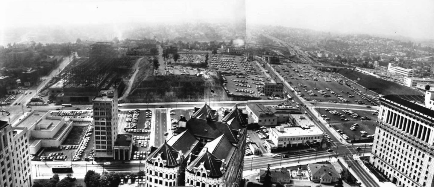
| (1958)* - Aerial view of downtown Los Angeles looking south from near Sunset Boulevard and Figueroa Street. Hope Street, between First and Temple Streets, would soon become the site of the DWP General Office Building and the Music Center. |
| Historical Notes
This 1958 aerial shows Bunker Hill at a turning point. The neighborhood still looks largely intact, with tightly packed homes and apartment buildings covering the hillside. But change was already underway. Demolition had begun near the Civic Center, and this stretch of Hope Street had already been chosen as the future site of the DWP headquarters and the Music Center. |
 |
|
| (1958)* - Annotated aerial view of Bunker Hill marking the future sites of the DWP General Office Building and the Music Center. Annotated by Jack Feldman. |
| Historical Notes
This annotated view shows where the DWP General Office Building and the Music Center would soon be built. At this point, most of the original structures were still standing, though clearance had begun along the edges. Within a decade, the area would be completely rebuilt. The new buildings would define downtown as a center of government and culture rather than a place where people lived. |
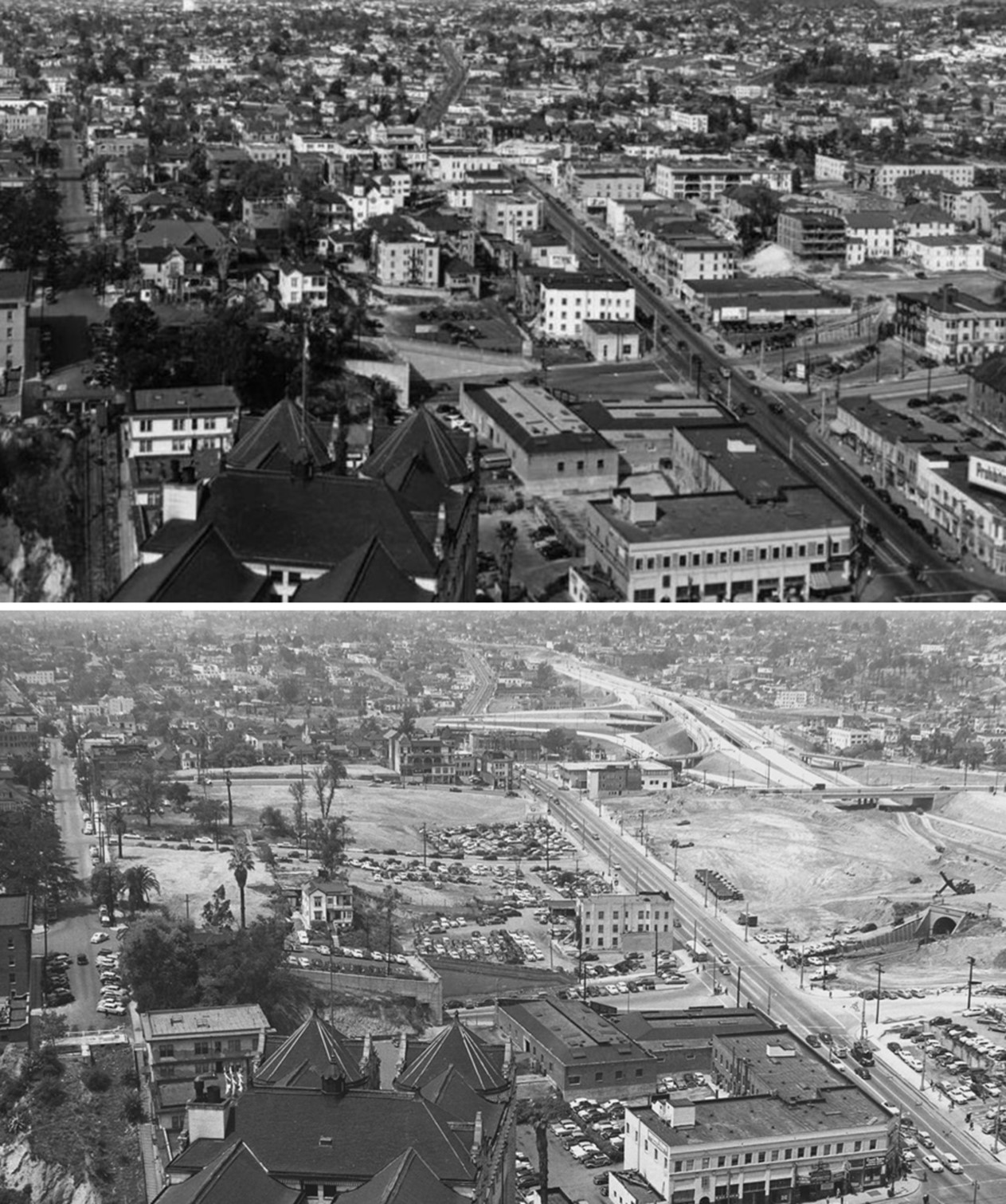
Before and After
 |
|
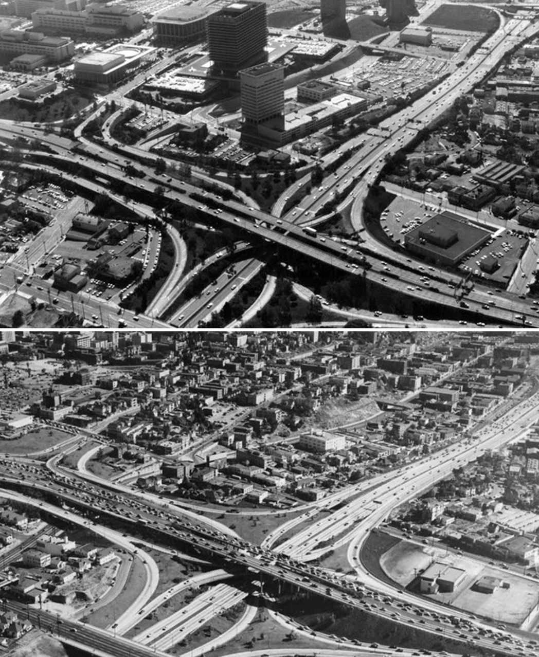
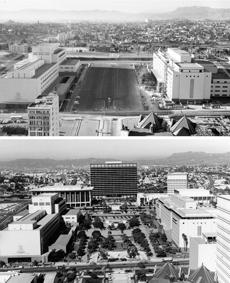
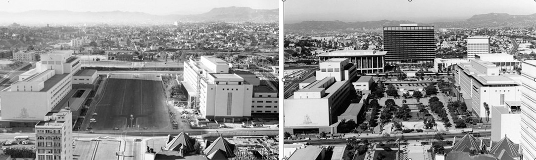
| (1954 vs. 1970)* - Aerial view looking southeast over the Four Level Interchange showing the transformation of Bunker Hill from a residential neighborhood into a civic center. Photo comparison by Jack Feldman. |
| Historical Notes
In 1954, Bunker Hill was still a working neighborhood filled with older homes, small hotels, and rooming houses. Many had been divided into smaller units, but the area was still full of people. By 1970, nearly all of it had been removed. In its place stood the DWP Building, the Music Center, and a new street system built for modern traffic and large scale development. |
Before and After
.jpg) |
|
| (1954 vs. 1970)* - Aerial view looking southeast showing the growth of the Civic Center skyline. |
| Historical Notes
These views show how quickly the downtown skyline changed in the postwar years. In 1954, City Hall still dominated the horizon. By 1970, it was joined by a new group of civic buildings. The Civic Center had grown, and a more modern downtown was taking shape. |
Before and After
.jpg) |
|
.jpg) |
|
| (1954 vs. 1970)* - Aerial view looking southeast over the Four Level Interchange showing Bunker Hill’s transformation from a working-class neighborhood into the city’s civic and cultural heart. |
| Historical Notes
The transformation of Bunker Hill was not only physical. It marked a shift in how Los Angeles defined its downtown. Housing gave way to civic institutions, including government offices, cultural venues, and courts. The area was rebuilt to serve the region as a whole rather than a local residential community. |
Then and Now
 |
|
 |
|
| (1954 vs. 2020)* - A Then and Now view of Bunker Hill, the Four Level Interchange, and the Downtown Skyline. Photo comparison by Jack Feldman. |
| Historical Notes
Nearly seventy years separate these views. The earlier image shows a hillside filled with homes and narrow streets. By 2020, the area had become a major cultural center, anchored by the Walt Disney Concert Hall and the Department of Water and Power’s John Ferraro Building. The hill itself had been reshaped into a broad plateau for modern development. |
Then and Now
 |
|
| (1954 vs. 2023)* - Aerial comparison of Bunker Hill and the downtown skyline showing continued development. Photo comparison by Jack Feldman. |
| Historical Notes
The transformation of Bunker Hill did not end in the 1960s. The 2023 view shows a skyline that continues to evolve, with new residential towers and cultural spaces added over time. What began as redevelopment has become an ongoing process of growth and change. |
Then and Now
 |
|
| (1957 vs. 2023)* - Aerial comparison looking southeast showing the expansion of the Civic Center and Bunker Hill skyline. Photo comparison by Jack Feldman. |
| Historical Notes
These images show how the Civic Center expanded from a low rise district into a dense urban skyline. The earlier view still reflects the scale of prewar Los Angeles. Today, the area is defined by tall buildings, freeways, and modern infrastructure. Much of this change began with the clearance of Bunker Hill more than sixty years ago. |
* * * * * |
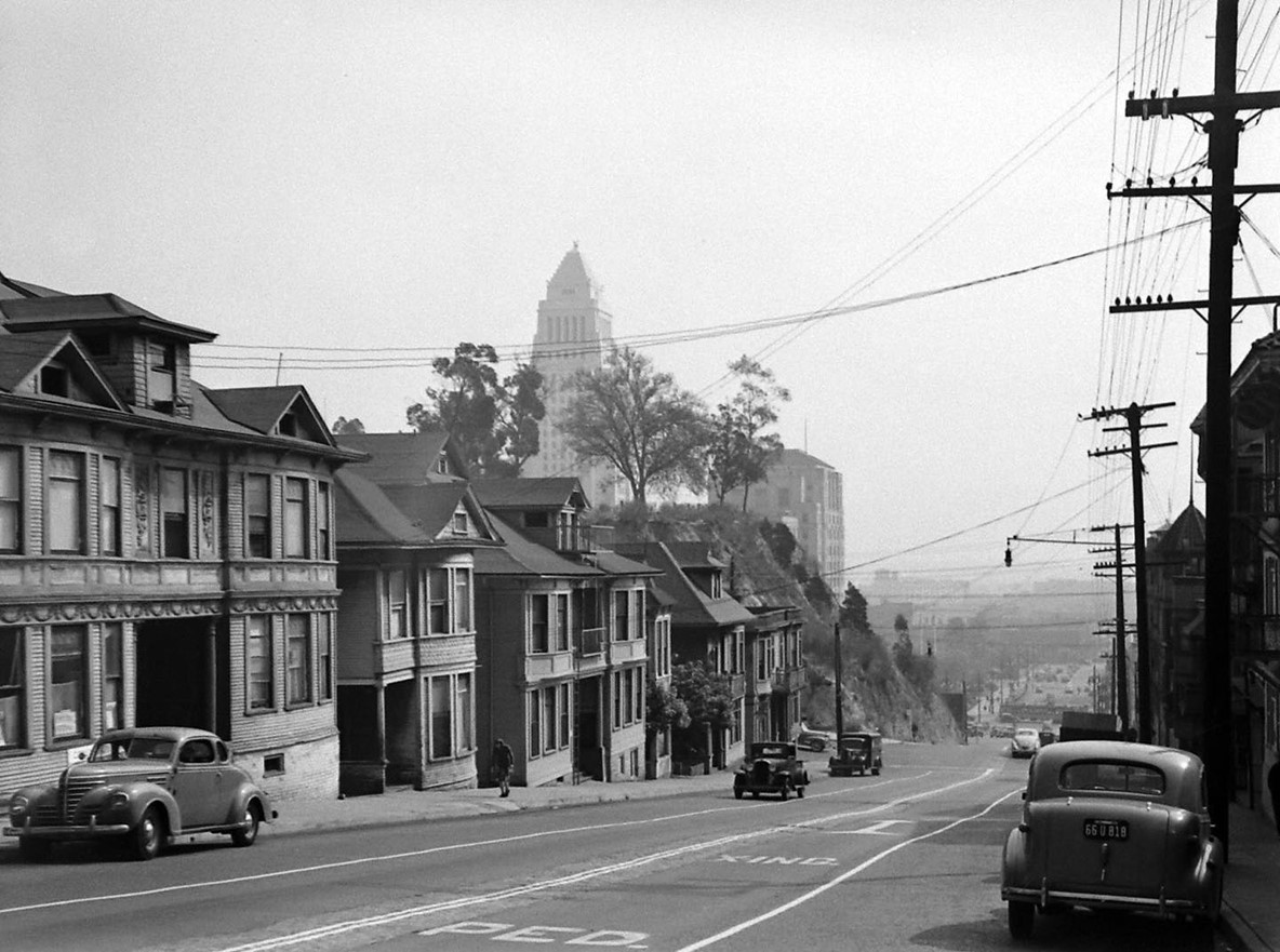
Bunker Hill from City Hall |
Before redevelopment, Bunker Hill could be seen clearly from the upper floors and observation deck of Los Angeles City Hall. These views from the late 1930s and 1940s provide some of the most complete records of the neighborhood as it once existed, a dense hillside of Victorian homes, boarding houses, and narrow streets just west of the Civic Center.By this time, the hill had already changed. What had once been a fashionable residential district had become a working class neighborhood of subdivided homes and rooming houses. City officials increasingly viewed it as a problem to be solved rather than a community to be maintained.These images capture Bunker Hill during that transition. They show the neighborhood in its final years, along with the early forces that would soon reshape it, including redevelopment policy, freeway construction, and changing ideas about how a modern city should function. |
 |
|
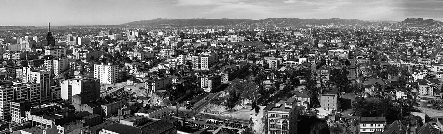
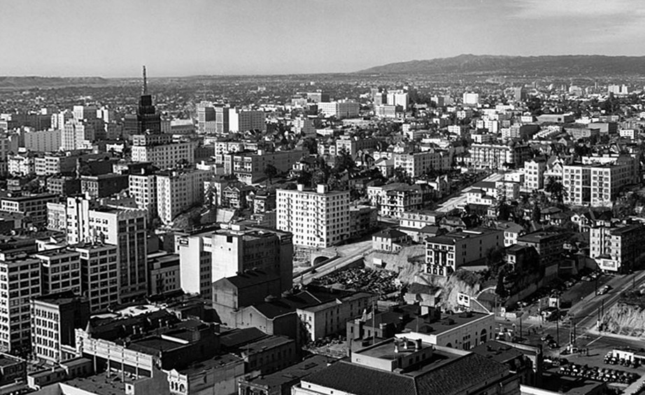
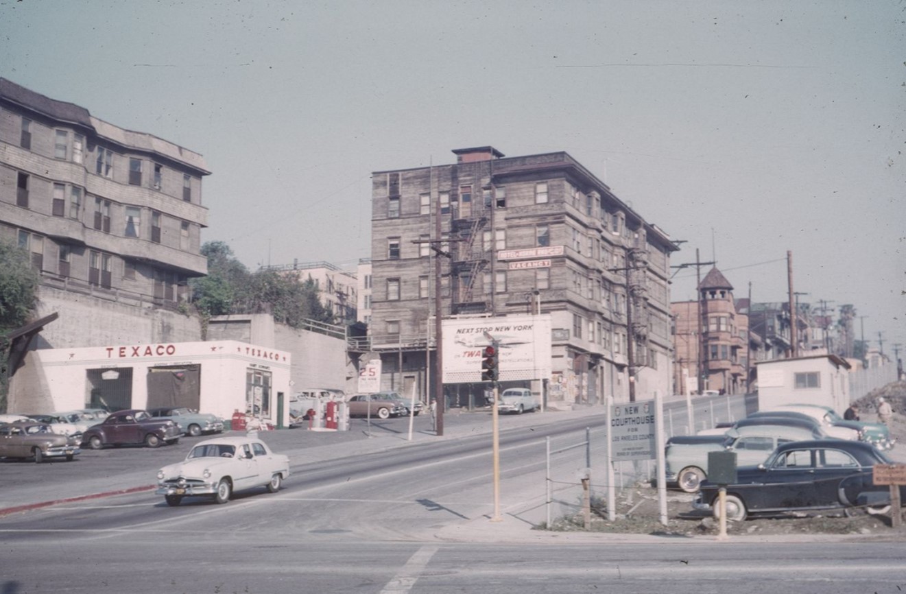
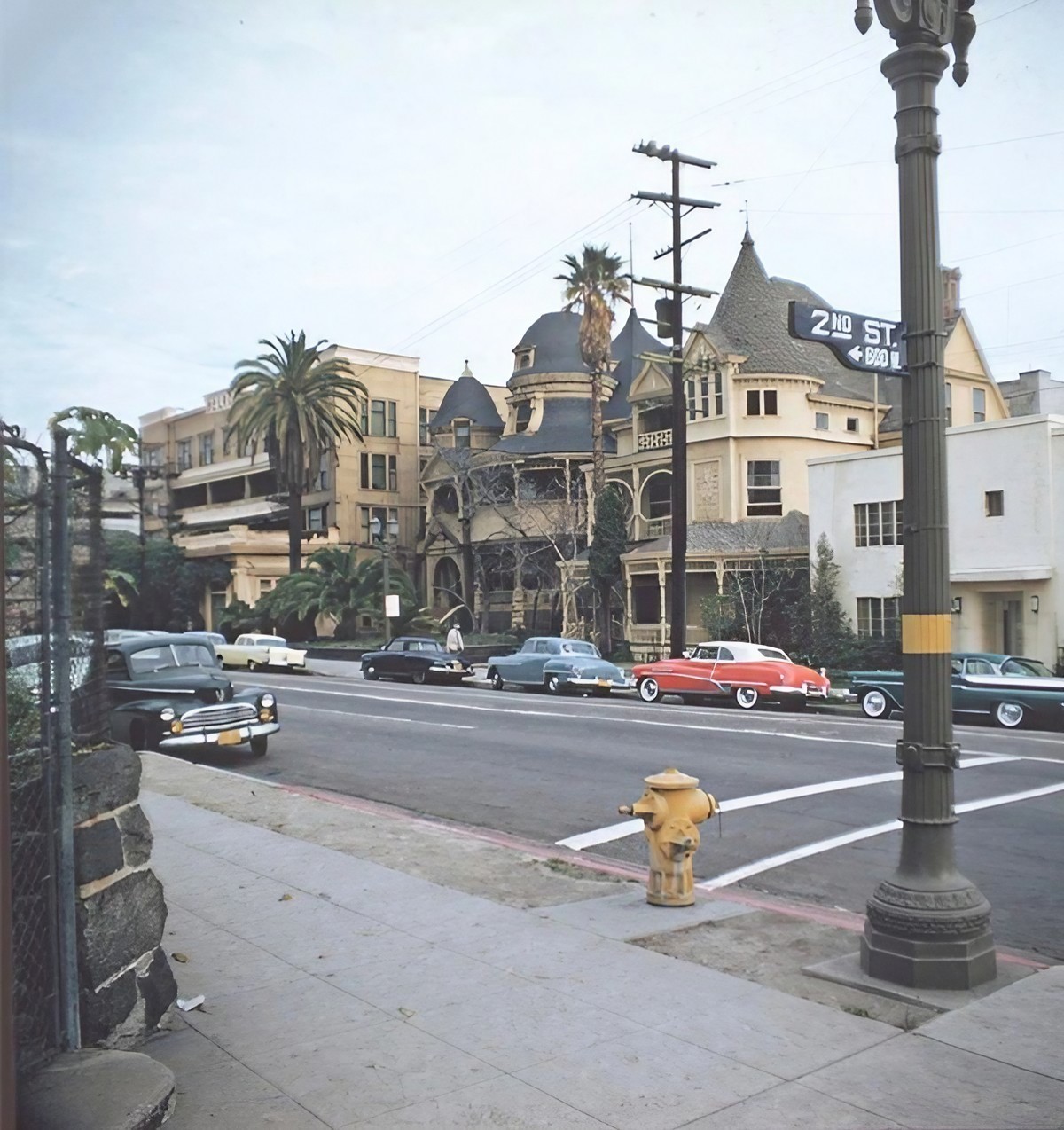
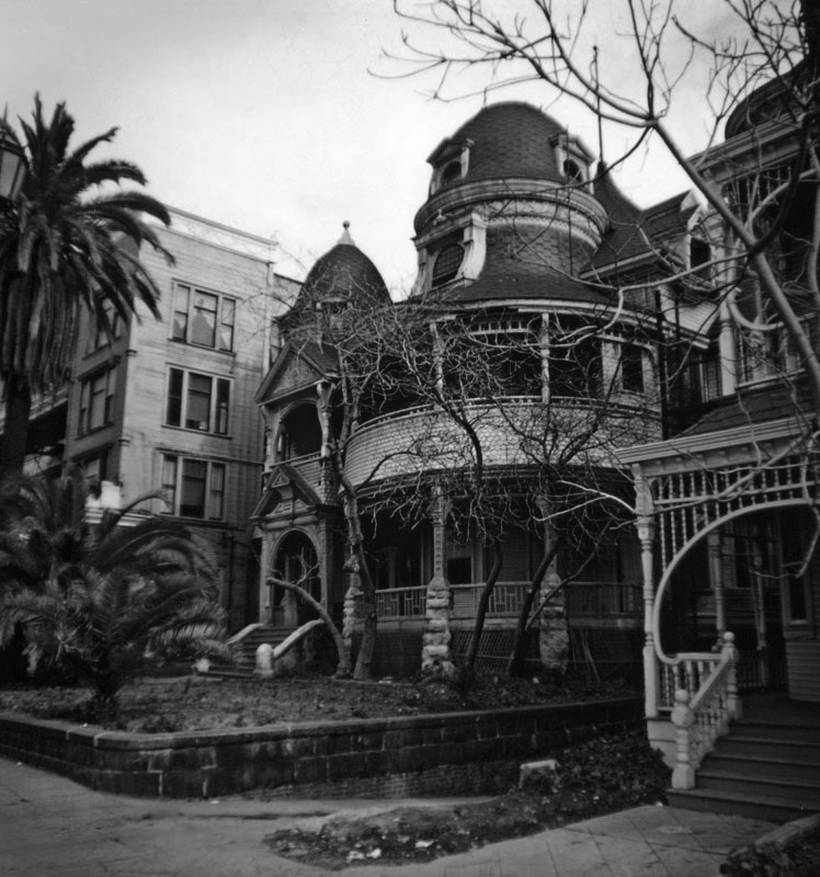
| (ca. 1939)* - Panoramic view of Bunker Hill as seen from City Hall. The intersection of Hill and First Streets is visible at lower right. |
| Historical Notes
This panoramic view looks directly into the heart of Bunker Hill. Rows of Victorian homes, boarding houses, and small apartments cover the hillside with very little open space between them. By the late 1930s, many of these homes had been divided into smaller units. The neighborhood remained home to working people, elderly residents, and others who could not afford newer parts of the city. |
 |
|
| (ca. 1939)* - Panoramic view of Bunker Hill as seen from City Hall (Right Panel). |
| Historical Notes
This view focuses on the central portion of the hill, where many of the larger Victorian homes had been converted into boarding houses. Their size and design reflect an earlier era, even as their use had changed. Most of these buildings remained standing until the late 1950s and early 1960s, when redevelopment cleared the area. |
 |
|
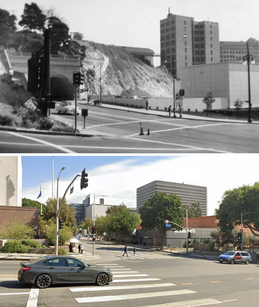
| (ca. 1939)* - Panoramic view of Bunker Hill as seen from City Hall (Left Panel). Second Street Tunnel can be seen in center of photo. |
| Historical Notes
The Second Street Tunnel, completed in 1924, cuts through the hillside to improve access between downtown and points west. It was one of the first major changes to the hill's form. It showed that the landscape could be altered when needed, a pattern that would continue on a much larger scale in the years ahead. |
 |
|
| (ca. 1937)^* - View looking northwest from the City Hall tower over the Hall of Records. Bunker Hill is covered with dwellings. |
| Historical Notes
Temple Street runs diagonally from the lower right toward the hill. The Hall of Records sits in the foreground, extending from Spring Street to Broadway. Court Street and Court Flight can be seen near the left side. In the distance, the Hollywood Hills rise above the city with the Hollywoodland sign faintly visible along the ridge. |
 |
|
| (ca. 1940)* – Postcard aerial view looking northwest showing City Hall and the Civic Center. The State Building and Hall of Records can be seen on Spring Street at center-left. The Hall of Justice, Federal Courthouse and U.S. Post Office Building (built in 1940), and International Bank Building are at center-right on Temple Street (to the right of City Hall). Bunker HIll at upper-left is still covered with residential buildings. |
| Historical Notes
This view highlights the contrast between the Civic Center and Bunker Hill. Government buildings formed an orderly district around City Hall, while the hill remained dense and irregular. Within two decades, that contrast would disappear as redevelopment pushed westward across the hill. |
 |
|
| (1943)* – Night view looking west toward Bunker Hill as seen from the observation deck of City Hall with the LA County Hall of Records in the foreground. All the streets are lit up including Broadway (running left to right at bottom), Temple Street (right), and Court Street (running away from the camera at center). |
| Historical Notes
This nighttime view shows the street grid clearly lit below, including Broadway, Temple Street, and Court Street. Bunker Hill rises beyond in relative darkness, still filled with homes and apartments before redevelopment began. |
 |
|
| (1945)* - Aerial view over Bunker Hill looking east toward the Los Angeles Civic Center before construction of the Hollywood and Harbor freeways. Temple Street is on the left running away from the camera. Court Street is on the right running toward the Old Hall of Records and City Hall buildings. A small section of First Street can be seen at upper-right. Figueroa Street runs horizontally at bottom. |
| Historical Notes
In 1945, California passed a law allowing cities to clear areas they considered blighted. Bunker Hill soon became one of the first major projects under this program. Although the neighborhood appears intact here, decisions had already been made that would lead to its clearance. Many residents were displaced and most buildings were demolished despite early plans that suggested some preservation. |
 |
|
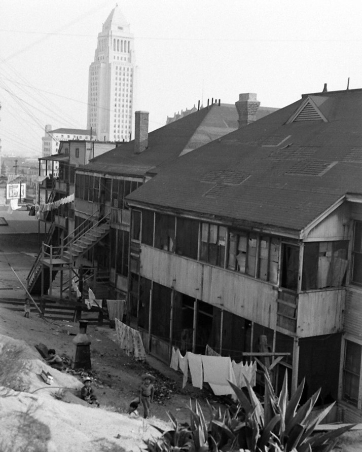
| (1946)* - Bunker Hill looking east toward City Hall. Photo by Walter Sanders for LIFE Magazine. |
| Historical Notes
This image was part of a LIFE Magazine series that focused on neighborhoods seen as declining. Portrayals like this helped shape public opinion and built support for redevelopment, even as Bunker Hill remained an active and populated community. |
 |
|
| (1949)* - Aerial view showing the construction of the four-level interchange (top of photo). Note that Bunker Hill is still covered with apartment buildings and houses. |
| Historical Notes
This view captures two major changes happening at once. The freeway interchange under construction at the top of the photo marks the rise of an automobile focused city. At the same time, Bunker Hill remains intact below. Within a few years, redevelopment programs would lead to its removal, making way for a very different downtown landscape. |
* * * * * |
Bunker Hill – Northern Edge and the Path to Redevelopment |
The northern edge of Bunker Hill shows the neighborhood in transition. By the early 1950s, much of the hill remained intact, but change was already underway. Parking lots were beginning to appear, and freeway construction was reshaping nearby land.This section captures Bunker Hill in its final phase as a residential district, before it was cleared and rebuilt as part of the expanding Civic Center. |
The North End of Bunker Hill (1951–1953) |
In the early 1950s, the northern portion of Bunker Hill was still densely built, with homes and apartment buildings covering the hillside. From the Hall of Records, the neighborhood appears active and intact.At the same time, early signs of change were visible. The Four Level Interchange was under construction nearby, and scattered parking lots had begun to replace older buildings. The area stood on the edge of a major transformation. |
 |
|
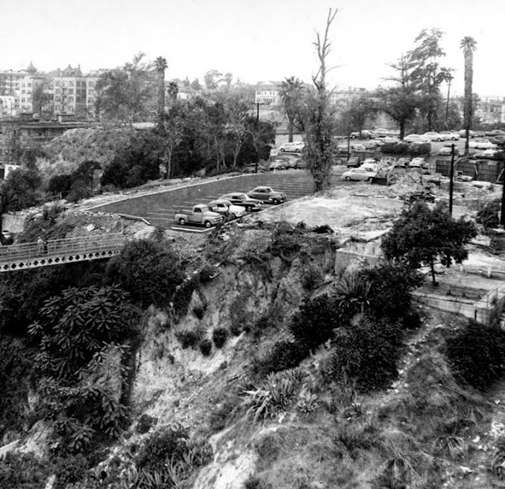
| (1951)* – View looking northwest from the top of the Hall of Records showing Bunker Hill as it appeared in the early 1950s. The Four Level Interchange is seen under construction at center-right. Parking lots fill the void where apartment houses once stood. Court Street is seen at left running away from the camera. At lower-right is the intersection of Temple and Hill streets. At lower-center is the northern terminus of the Hill Street Tunnels. The Hollywood Hills and Hollywood Sign can be seen in the distance. |
| Historical Notes
In 1951, most of Bunker Hill was still standing. Despite early clearance nearby, the area remained a working residential neighborhood. Over the next decade, the hill would be graded down and rebuilt as part of the Civic Center expansion, including the Music Center and the DWP General Office Building. |
 |
|
| (1951)* – View looking northwest from the top of the Hall of Records showing Bunker Hill as it appeared in the early 1950s. |
| Historical Notes This view shows how much of the original neighborhood was still intact. Streets, homes, and apartment buildings still formed a continuous residential district. The surrounding areas were beginning to change, but Bunker Hill itself had not yet been touched. |
 |
|
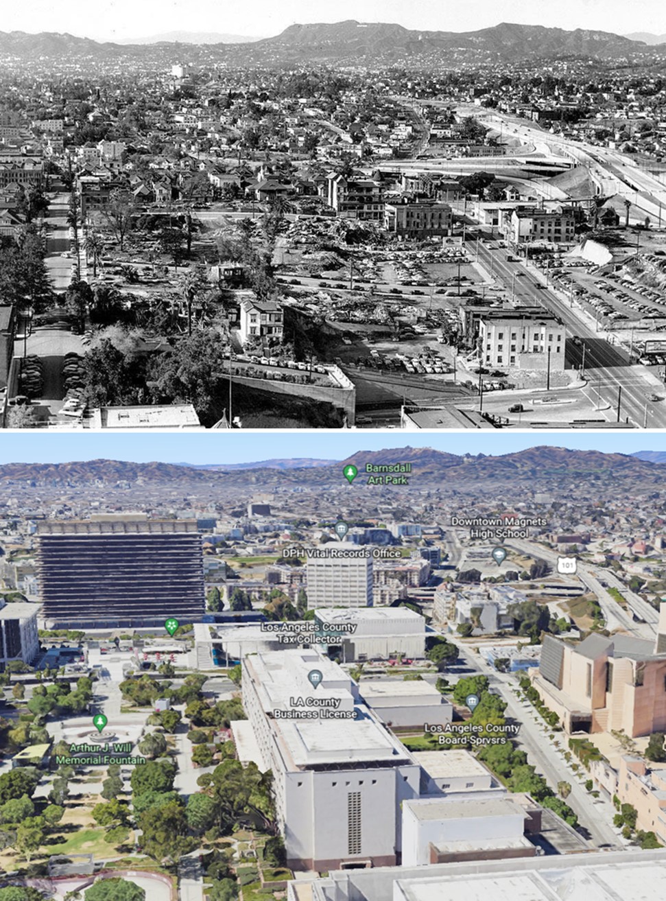
| (2022)* - Google Earth view of Bunker Hill (North) with the Hollywood Hills in the background. |
| Historical Notes Today, the northern end of Bunker Hill looks almost nothing like it once did. The hillside that held homes and apartments is now occupied by civic buildings, office towers, and cultural institutions. The Hollywood Hills in the background are the one thing that has not changed. |
Then and Now
 |
|
| (1951 vs. 2022)* - Looking toward the Hollywood Hills over Bunker Hill (North). Photo comparison by Jack Feldman. |
| Historical Notes Placed side by side, these two scenes show the full extent of change. The dense residential hillside of 1951 has been replaced by a civic and commercial landscape. Only the distant hills look the same. |
 |
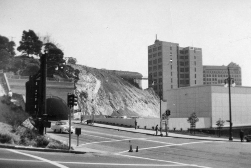
|
| (ca. 1953)* - Aerial view of the northern edge of Bunker Hill and the remnants of Fort Moore Hill. In the foreground, the roof of the Hall of Records is visible on the left, with the corner of Broadway and Temple streets on the right. In the background, freeway construction has largely decimated Fort Moore Hill, leaving only the south portal of the Pacific Electric tunnel. Court Street is seen facing the camera on the left. Photo by Arnold Hylen. |
| Historical Notes Fort Moore Hill once stood just northeast of Bunker Hill. By the early 1950s, freeway construction had largely removed it. The Pacific Electric tunnel portal visible here was one of the last traces of that earlier landscape. Within a few years, Bunker Hill itself would go through a similar transformation. |
Before and After
 |
|
| (1937 vs 1953)* - Before and After - Photo comparison by Jack Feldman. |
| Historical Notes These images show how quickly the edges of Bunker Hill were changing even before formal redevelopment began. Freeway construction and early clearance had already reshaped the northern edge by 1953, years before the main demolition got underway. |
 |
|
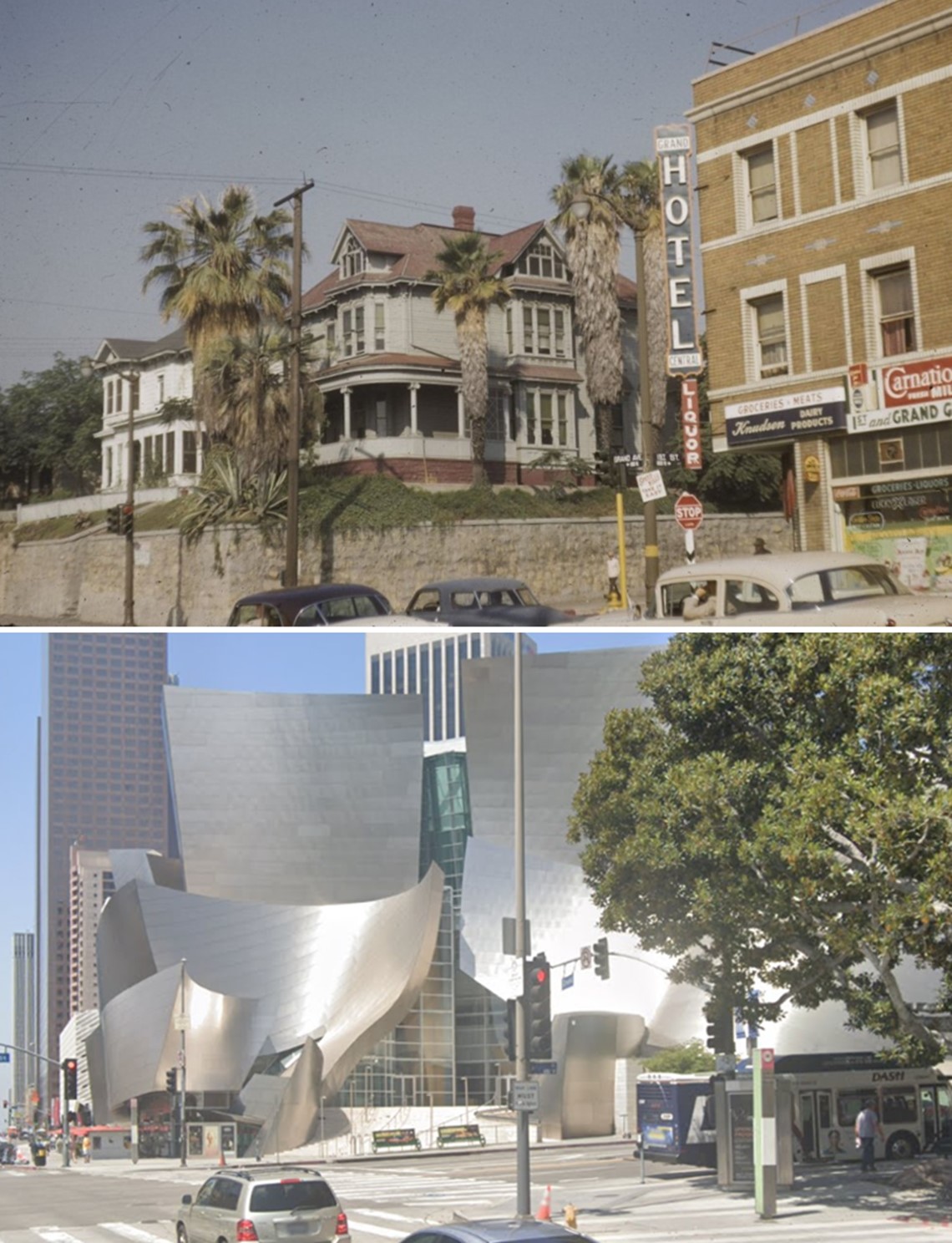
| (1954)* - Temple Street looking west. The northern terminus of the Hill Street Tunnels is seen center-left with cars parked on top. In the distance at upper-right can be seen the St. Angelo Hotel located on the west side of Grand Avenue just north of Temple Street. This would be current site of the Ahmanson Theatre. |
| Historical Notes
The first Hill Street Tunnel was completed in 1909 by Los Angeles Pacific, a predecessor of Pacific Electric. A second tunnel followed in 1913 for streetcar use. Together they helped move people through the steep terrain of Bunker Hill. The St. Angelo Hotel visible in the distance would remain standing for only a few more years before the site was cleared for the Music Center. |
 |
|
| (ca. 1954)* - Panoramic view looking northwest, showing Olive Street intersecting with Temple Street at the upper center-right. The St. Angelo Hotel is visible in the left background on Grand Avenue. The foreground marks the future site of the Los Angeles County Hall of Administration. The future site of the Music Center, where the St. Angelo Hotel currently stands, is in the background at the upper left. Parking lots are visible throughout. |
| Historical Notes
The parking lots seen here reflect a transitional moment for Bunker Hill. Buildings had been removed and the land was being held for future construction. A few structures still remained, surrounded by cleared and empty ground. |
 |
|
| (1950s)* – View looking southwest over the Hollywood Freeway towards the eastern edge of Bunker Hill, showing parking lots throughout. The Victorian-style structure seen in the distance is the St. Angelo Hotel, located at 237 N. Grand Avenue, near the southwest corner of Temple Street and Grand Avenue, where the Music Center stands today. |
| Historical Notes From this vantage point, the extent of early clearance is easy to see. Large sections of the hillside had already been opened up. What remained was a broken landscape of scattered buildings surrounded by cleared and empty lots. |
 |
|
| (1953)* - Looking west from across Temple Street towards the former St. Angelo Hotel, 4-story Queen Anne Revival style building located at 237 N. Grand Avenue. A banner hanging from the building reads: "This building not to be removed. Vacancies". A parking lot with several cars is directly across the street. |
| Historical Notes
The St. Angelo Hotel was built in the 1880s during one of Los Angeles' early building booms. By the 1950s, it was one of the last prominent reminders of Bunker Hill's earlier years. Despite efforts to keep it open, the building was ordered vacated in 1956. It was soon demolished, and the site became part of the Music Center, which opened in 1964. |
* * * * * |
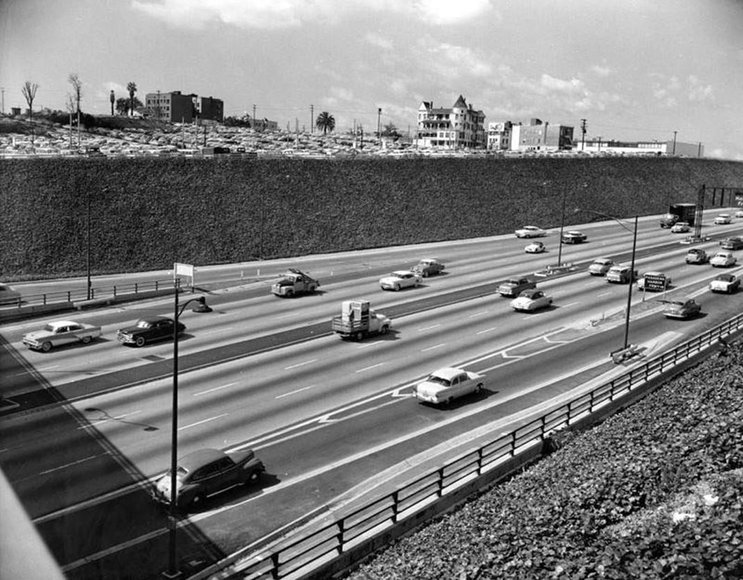
Clearance and the Expansion of the Civic Center (1954–1956) |
During the mid 1950s, much of Bunker Hill had been cleared. Large sections of the hillside were reduced to open land and temporary parking lots.Construction soon followed. New civic buildings, including the County Courthouse, began to rise as part of a broader plan to expand the Civic Center. |
 |
|
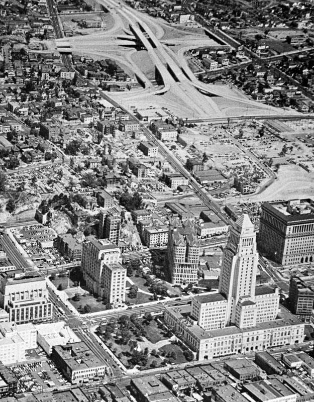
| (1954)* - Aerial view looking southeast over the newly constructed four-level interchange showing Bunker Hill (center-right), future home of both the DWP General Office Building (GOB) and the Music Center. |
| Historical Notes
The Four Level Interchange, completed in stages between 1949 and 1953, was the first stack interchange in the world. By 1954, the land surrounding it was already being cleared and prepared for redevelopment. |
 |
|
| (1954)* - Aerial view looking southeast across the four-level interchange and Bunker Hill showing the future home of the Department of Water and Power General Office Building. |
| Historical Notes The site shown here would become the Department of Water and Power headquarters. Much of the surrounding area had already been cleared. Open ground was all that remained, waiting for construction to begin. |
* * * * * |
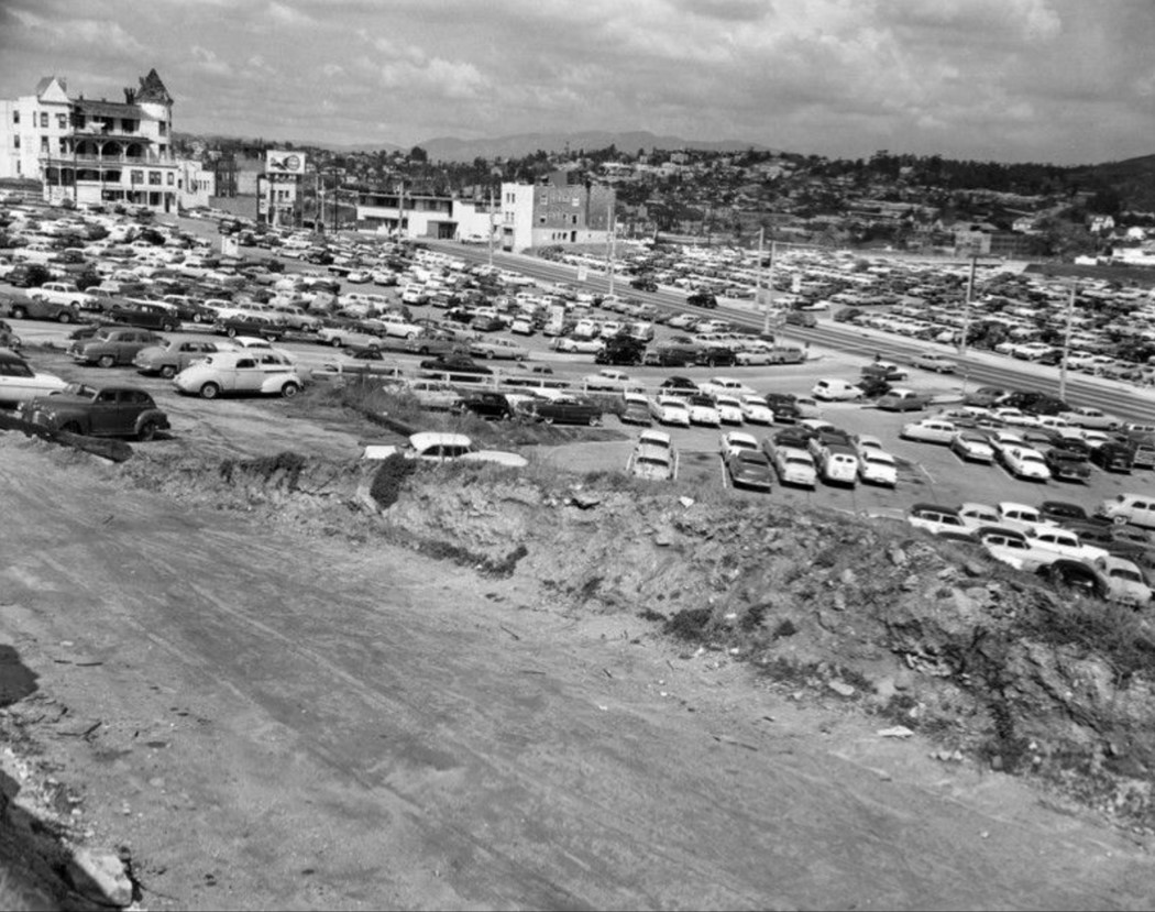
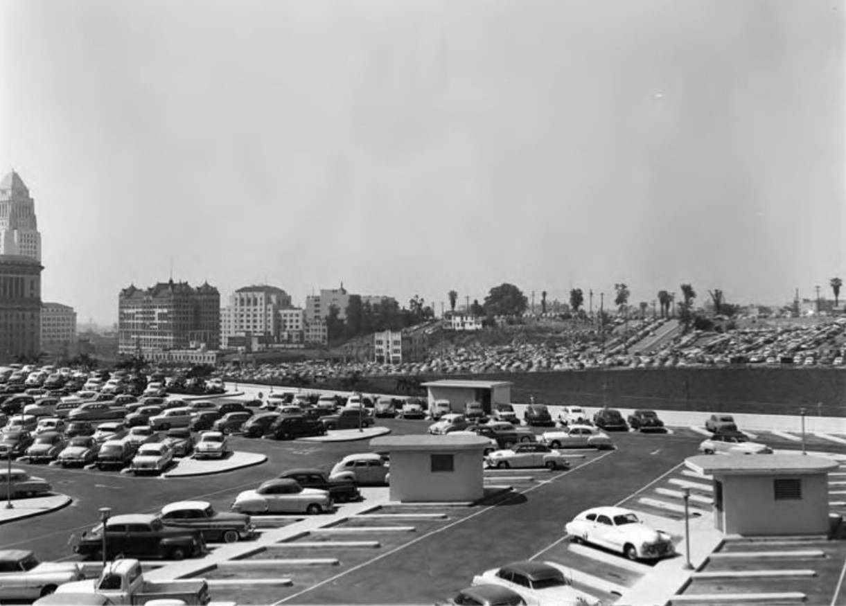
Bunker Hill Parking |
By the early 1950s, Bunker Hill had entered the final stage of its long transition from one of Los Angeles' most desirable residential neighborhoods to an area marked for redevelopment. Once known for its Victorian homes, hotels, and commanding views of downtown, the hill gradually changed as residents and investment moved westward.As buildings were removed and plans for redevelopment advanced, large portions of cleared land became temporary parking lots. These lots served downtown workers, Civic Center visitors, and the growing number of commuters arriving by automobile.The photographs in this section capture that brief but important period when Bunker Hill existed between two eras. Much of the old neighborhood still remained, yet the future Civic Center expansion, Music Center, and major government buildings were already beginning to reshape the landscape. |
 |
|
| (1954)* - View looking southeast showing Bunker Hill and part of the Los Angeles Civic Center. Parking lots appear throughout the area. |
| Historical Notes
This view captures Bunker Hill during one of the most dramatic periods in its history. The parking lots visible across the hill were not simply vacant land but part of a larger redevelopment effort already underway as properties were acquired and older structures removed. Within a few years, the pace of change accelerated. Much of the land visible here would be transformed through grading and redevelopment to support Civic Center expansion and major projects including the Dorothy Chandler Pavilion, Ahmanson Theatre, and the Department of Water and Power Building. |
 |
|
| (ca. 1954)* - Bunker Hill parking lot with the Hall of Records and Los Angeles City Hall visible in the background. |
| Historical Notes
This photograph illustrates the transitional character of Bunker Hill during the 1950s. Surface parking increasingly occupied land once filled with homes, apartments, and neighborhood businesses. The buildings in the background help place this scene in time. The Hall of Records, completed in 1911, and Los Angeles City Hall, completed in 1928, stood at the center of a rapidly expanding Civic Center. For many longtime residents, the spread of parking lots signaled that Bunker Hill was no longer being renewed but fundamentally transformed. |
|
|
| (ca. 1954)* - Panoramic view looking northwest, showing Olive Street intersecting with Temple Street at the upper center-right. The St. Angelo Hotel is visible in the left background on Grand Avenue. The foreground marks the future site of the Los Angeles County Hall of Administration. The future site of the Music Center, where the St. Angelo Hotel currently stands, is in the background at the upper left. Parking lots are visible throughout. |
| Historical Notes
This panoramic view preserves a landscape in transition. The open land in the foreground would soon become the Los Angeles County Hall of Administration, completed in 1960 as part of the expanding Civic Center. The St. Angelo Hotel remained one of the last visible reminders of Bunker Hill's earlier residential character. It was demolished later in the decade to make way for the Music Center, which opened in phases beginning in 1964 and became one of Los Angeles' premier cultural destinations. |
|
|
| (1950s)* – View looking southwest across the Hollywood Freeway toward the eastern edge of Bunker Hill showing extensive parking areas. The St. Angelo Hotel, a structure from the Victorian era, stands in the distance at 237 North Grand Avenue near Temple Street, on the future site of the Music Center. |
| Historical Notes
The construction of the Hollywood Freeway further separated Bunker Hill from surrounding neighborhoods and reinforced downtown's growing dependence on automobiles. Parking lots spread across cleared land while a small number of older structures remained. The St. Angelo Hotel became one of the final symbols of Bunker Hill's earlier identity before the site was cleared and redevelopment permanently reshaped the hill. |
* * * * * |
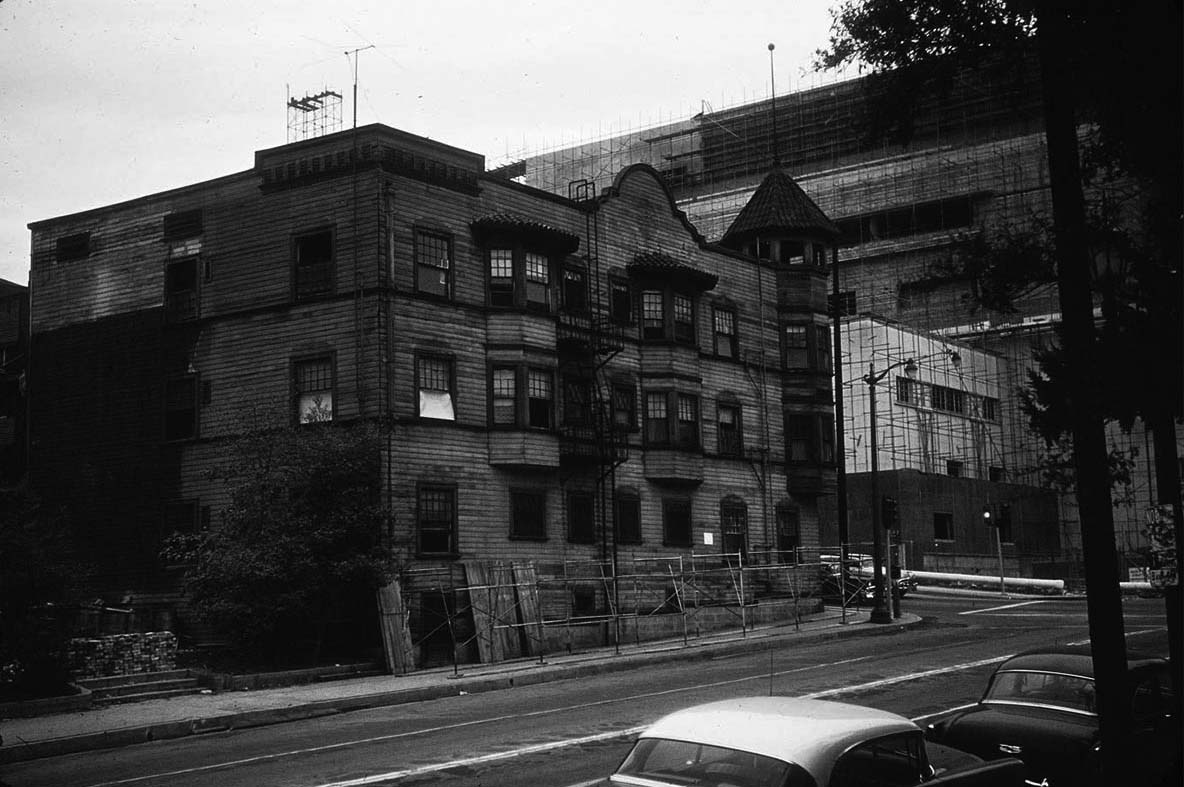
Los Angeles County Courthouse (Stanley Mosk County Courthouse) |
 |
|
| (1956)** - Panoramic photograph composite taken from the City Hall tower, facing west to northwest towards Bunker Hill and Hollywood. Bunker Hill has been slightly shaved off to make room for the County Courthouse, which is under construction, as well as several parking lots. There are still a few remaining dwellings at the far end of Bunker Hill. | Broad |
| Historical Notes By 1956, much of Bunker Hill had been graded and cleared. A few buildings could still be seen at the far edge of the hill. But the central area had already been opened up, waiting for the new civic buildings that would soon follow. |
 |
|
| (1956)* – View looking northwest from above Hill Street towards Grand Avenue and Bunker Hill showing the early stages of construction on the Los Angeles County Courthouse. 1st Street is on the left and the building with the turret in the upper-left is the Seymour Apartments. |
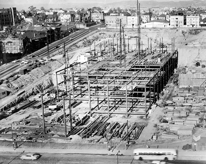
| Historical Notes Los Angeles County had gone nearly 26 years without a dedicated courthouse after the 1891 sandstone courthouse was damaged in the 1933 Long Beach earthquake. The new building, designed in part by Paul R. Williams, was built to house both municipal and superior courts. According to the Los Angeles Times, the architects designed it to last 250 years. |
 |
|
| (1956)**^ – View looking northeast showing the steel framing of the new County Courthouse located on the north side of First Street between Grand Avenue and Hill Street. In the distance (upper-right) can be seen the Hall of Justice, Federal Building, and the Hall of Records. In the foreground is a row of apartment buildings on the south side of First Street. The building with the turret in the right foreground is the Seymour Apartments (S/W corner of First and Olive). |
| Historical Notes This scene shows the contrast between old and new. On one side of First Street, the new courthouse was rising fast. On the other side, a few remaining apartment buildings still stood. They would not be there much longer. |
* * * * * |
First and Olive |
The intersection of First Street and Olive Street marked the eastern edge of Bunker Hill, where the residential neighborhood met the expanding Civic Center. In the years before redevelopment, this corner was lined with apartment buildings, boarding houses, and hillside structures that climbed toward the crest of the hill. The Seymour Apartments, with their distinctive turret, stood on the southwest corner as one of the last visible reminders of Bunker Hill’s earlier residential character. By the mid 1950s, change was already underway. Across First Street, the new County Courthouse was rising on cleared land as part of the Civic Center expansion. Groundbreaking took place in March 1954, led by Chief Justice Earl Warren, just weeks before the Supreme Court decision in Brown v. Board of Education. The courthouse, designed in part by Paul R. Williams, marked the city’s shift toward a modern civic center. The buildings along First Street were nearing the end of their time. This location is especially important because the change was not limited to demolition. The hill was cut down. In places, up to 30 feet of earth was removed from the top of Bunker Hill to create a level surface for development. First Street no longer rises the way it once did. The Then and Now views in this section show not just a change in buildings, but a permanent reshaping of the land. |
.jpg) |
|
| (1957)* – View looking west on 1st Street at Olive Street with the Seymour Apartments on the southwest corner. All the buildings on the south side of 1st Street will be demolished within a year. |
| Historical Notes The Seymour Apartments stood on the southwest corner of First and Olive as one of the last substantial residential buildings in this part of Bunker Hill. By 1957, the redevelopment line had reached this block, and tenants had already begun to move out. Within a year, the buildings along the south side of First Street would be demolished. The land would then be graded and prepared for the civic development that followed. |
 |
|
| (1957)* – View looking northwest showing the Seymour Apartments (S/W corner of 1st and Olive) shortly before the building was demolished. Across 1st Street can be seen the County Courthouse under construction. |
| Historical Notes This view places the Seymour Apartments alongside the future that would replace it. Across the street, the County Courthouse was under construction, rising above cleared ground. The contrast is direct. A Victorian era structure stands beside a modern civic building designed for permanence. Within a short time, the older structure would be gone. |
 |
|
| (ca.1950)* – View looking west on 1st Street at Olive Street toward the top of Bunker Hill. |
| Historical Notes Around 1950, First Street at Olive still reflected the scale of a residential neighborhood. Apartment buildings and rooming houses lined the street as it climbed toward the top of Bunker Hill. The slope of the street is an important detail. That rise would later be reduced when the hill was cut down during redevelopment. The street seen here no longer exists in this form. |
.jpg) |
|
| (1945)* – Close-up view of the northwest corner of 1st Street and Olive Street, today the side entrance to the Stanley Mosk Courthouse. |
| Historical Notes This 1945 view shows the northwest corner of First and Olive when the area was still fully residential. Buildings were closely spaced and typical of Bunker Hill’s apartment district. Today, this location is part of the grounds of the Stanley Mosk Courthouse. The street remains, but the surrounding landscape has been completely rebuilt. |
Then and Now
 |
|
| Then and Now* – Looking west on 1st Street at Olive Street. Photo comparison by Jack Feldman. |
| Historical Notes
This comparison shows one of the most dramatic changes on Bunker Hill. The earlier image looks toward buildings that once stood near the top of the hill. In the modern view, the land has been lowered by up to 30 feet, so that today’s street sits far below the level seen in the older photograph. The buildings were removed, but more importantly, the hill was reshaped. |
.jpg) |
|
| (1955)* - Buildings in Los Angeles Civic Center are barely visible in picture looking east at 1st and Olive Streets when smog was at its peak. Photo by John Malmin / Los Angeles Times |
| Historical Notes
This 1955 image looks east at First and Olive during one of the worst periods of air pollution in Los Angeles. Buildings in the Civic Center are barely visible through the haze. At the time, smog was widely viewed as a local condition, caused by geography and weather patterns rather than a broader environmental issue. |
Then and Now
.jpg) |
|
| (1955 vs. 2016)* - Looking east on 1st Street at Olive Street in DTLA. Two things stand out here: (1) the change in air quality since 1955 (top photo) and (2) how much 1st Street was lowered during redevelopment. Photo comparison by Jack Feldman. |
| Historical Notes
By the mid 1950s, scientists had begun to identify automobiles as a major source of smog. Yet meaningful change came slowly. It was not until 1975 that federal law required catalytic converters on new cars, leading to a steady improvement in air quality. The clearer skies in the modern view reflect that progress. At the same time, the comparison also reveals the reshaping of Bunker Hill. The air above the city improved, while the land below was permanently altered. Click HERE to see more Smog in Early Los Angeles. |
* * * * * |
First and Grand |
Grand Avenue has long been one of Bunker Hill’s defining streets. Originally laid out as Charity Street in the 1800s, it was renamed Grand Avenue in 1887 as the hill reached the height of its residential prominence. By the 1940s and 1950s, the area around First Street had changed. Large homes had given way to apartments, small hotels, and neighborhood businesses that served a dense, working community.The intersection of First Street and Grand Avenue became one of the most important corners on the hill. The buildings seen in these images stood on ground that later became part of the Dorothy Chandler Pavilion and the Walt Disney Concert Hall. Neither could have existed without the clearance and reshaping of the hill.A neighborhood built for daily life was replaced by a civic and cultural center designed for a regional audience. These images show the full extent of that change. Every structure at this intersection was removed, the street grade was lowered, and the landscape was reshaped. |
 |
|
| (1945)* - Looking east on First Street from Grand Avenue towards Olive, with City Hall and the California State Building visible over the hill on the left. |
| Historical Notes This 1945 view looks east along First Street as it climbs across Bunker Hill. Apartment buildings and small commercial spaces line the corridor, reflecting the everyday character of the neighborhood. City Hall rises in the distance, marking the Civic Center beyond the hill. Within a few years, that district would expand westward, replacing the residential streetscape seen here. |
Then and Now
 |
|
| (1945 vs 2022)* - Looking east on First Street from Grand Avenue. Photo comparison by Jack Feldman. |
| Historical Notes These images show the same scene nearly eighty years apart. In 1945, First Street follows the natural slope of the hill, rising toward Olive Street. In the modern view, the street has been lowered and rebuilt as part of the civic landscape. City Hall remains the constant in the distance, while everything in the foreground has changed. |
 |
|
| (1954)* – Looking SW toward the intersection of Grand and 1st streets. On the SW corner can be seen two house addressed 103 and 109 South Grand Avenue. At right, NW corner, is the Grand Central Hotel at 101 North Grand Avenue. Photo by Palmer Conner |
| Historical Notes This 1954 image captures the intersection at close range. Houses, apartments, and the Grand Central Hotel reflect the mixed character of Bunker Hill at the time. The southwest corner seen here later became part of the site of the Walt Disney Concert Hall. |
 |
|
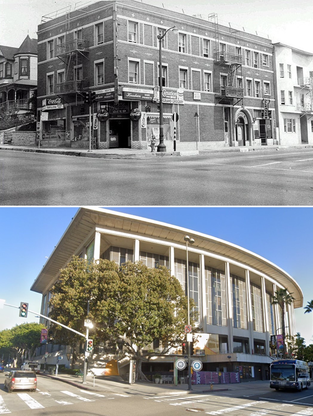
| (ca. 1955)* - Looking north across the intersection of W. First Street (running from middle left to lower right) and N. Grand Avenue towards an apartment building, located at 601-603 W. First Street, with Grand Grocery occupying the ground floor; on the far left is the Queen Anne Revival style apartment house at 609-611. Directly to the right of the market is the New Grand Cleaners on the ground floor of the Grand Central Hotel at 103-107 N. Grand Avenue and another apartment building with the addresses of 109, 109 1/2, 111, and 111 1/2. |
| Historical Notes This image captures the intersection as a functioning neighborhood. Businesses such as a grocery and cleaners served residents living in the apartments above. The density of buildings and storefronts reflects a community centered on daily activity. Within a few years, this entire streetscape would be cleared. |
Then and Now
 |
|
| (1954 vs. 2022)* – View looking toward the SW corner of Grand Avenue and 1st Street...present site of the Disney Concert Hall. |
| Historical Notes The earlier image shows small residential structures at the intersection. The modern scene reflects a major cultural landmark designed by Frank Gehry, completed in 2003. The scale and purpose have completely changed. What was once a residential corner is now part of a regional cultural destination. |
Then and Now
 |
|
| (1954 vs 2022)* - Looking at the NW corner of Grand Avenue and 1st Street....present site of the Dorothy Chandler Pavilion. Photo comparison by Jack Feldman. |
| Historical Notes In 1954, this intersection was occupied by the Grand Central Hotel and small businesses at street level. The buildings were part of the dense residential fabric of Bunker Hill. By 1964, the area had been cleared and rebuilt as the Dorothy Chandler Pavilion, the first completed element of the Music Center. The transformation marked the shift from neighborhood use to cultural center. |
Then and Now
 |
|
| (1955 vs 2023)* - Looking at the NW corner of Grand Avenue and 1st Street....present site of the Dorothy Chandler Pavilion. Photo comparison by Jack Feldman. |
| Historical Notes This later comparison highlights how the site has remained stable since redevelopment. The Pavilion continues to define the location, while the surrounding area has been further developed. The street still follows the same general alignment, but the grade is lower and the original neighborhood is gone. |
* * * * * |
Hill and 1st Street (Looking NE) |
The intersection of Hill Street and First Street marked the eastern edge of Bunker Hill, where the residential neighborhood met the growing civic and legal district. Hill Street passed through the hill by way of a pair of tunnels, built in the early 1900s to overcome steep terrain and improve access between downtown and the neighborhoods to the west.By the early 1950s, this area was changing. The Los Angeles County Law Library, completed in 1953, stood as one of the first new civic buildings at this edge of the hill. Nearby, older residential structures such as the Bixby house had been cleared and replaced by parking lots and office-related uses. These images capture a moment when the neighborhood still existed, even as redevelopment began to take hold.Within a few years, transformation accelerated. The Hill Street Tunnels were removed, the land was regraded, and the surrounding blocks were rebuilt as part of the expanding Civic Center. Only a few structures, including the Law Library, remained to connect the earlier landscape with what followed. |
 |
|
| (ca. 1953)* - Looking northeast across the intersection of W. First (foreground) and N. Hill streets (running diagonally from left to lower right), showing the Los Angeles County Law Library (right), the Law Building at 139 N. Broadway and the bridge to its parking lot (upper right and center) and the Hill Street Tunnels in the left background. |
| Historical Notes This 1953 view captures the intersection at a transitional moment. The Los Angeles County Law Library had just opened, marking the arrival of new civic development at the edge of Bunker Hill. The Hill Street Tunnels appear in the background, still in use. Built to carry streetcars and vehicles through the hill, they were removed only a few years later when the land above them was cut down. |
 |
|
| (ca. 1954)* - The footbridge to the Law Building from parking lot. The former Bixby house (a multi-family dwelling since circa 1914) had been cleared in 1953. |
| Historical Notes This image reflects the growing importance of office use and automobile access. The footbridge linked the Law Building to a parking lot created on land where residential structures once stood. The removal of the Bixby house marked an early stage of change. Like many homes on Bunker Hill, it had been converted to multi-family use before being cleared. |
Then and Now
 |
|
| (1953 vs. 2025)* - Looking northeast across the intersection of First and Hill Streets toward the twin portals of the Hill Street Tunnels and the eastern face of Court Hill, compared with the same location as it appears today. Photo comparison by Jack Feldman. |
| Historical Notes The 1953 photograph captured the Hill Street Tunnels during the final years of their existence. Both portals remained in service beneath the exposed eastern face of Court Hill, while redevelopment associated with the expanding Civic Center was already beginning to reshape the surrounding landscape. The modern view reveals the full extent of that transformation. The tunnels were demolished, Court Hill was excavated, and even the grade of First Street was lowered as portions of Court Hill and nearby Bunker Hill were cut away. The intersection visible today sits noticeably lower than it did in 1953. Few locations illustrate more clearly that Los Angeles did not simply grow over time. In many places, the city literally rebuilt its own landscape. Click HERE to see more Hill Street Tunnels - Then and Now views. |
* * * * * |
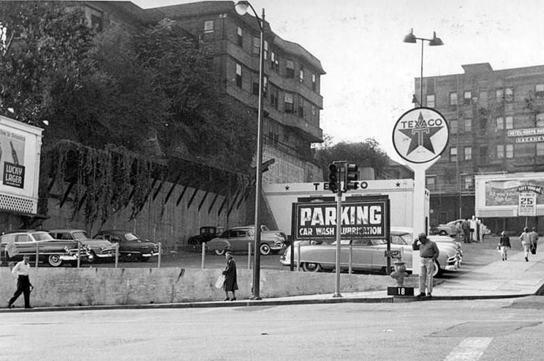
Hill and 1st Street (Looking SW) |
The southwest corner of Hill Street and First Street sat along the lower slope of Bunker Hill, where residential buildings, small hotels, and automobile-related businesses came together. By the early 1950s, this area reflected several stages of change. Older homes had been converted into lodging houses, while nearby lots had been cleared for parking and service uses.The El Moro Hotel, visible in these views, began as a private residence in the late 1800s before being converted to a hotel in the early 1900s. Its elevated position above Hill Street reflected the steep terrain that defined this part of the hill. At street level, newer uses such as a Texaco service station marked a different phase of development.These images capture a transitional landscape. Long-standing buildings remained, but the ground around them had already been altered. Within a few years, the hotels, service businesses, and the hillside itself would be removed and replaced as part of the Civic Center expansion. |
 |
|
| (ca. 1953)* – Looking at the SW corner of Hill and 1st streets showing the El Moro Hotel (upper left), a parking lot, a Texaco service station and car wash (right of center). Also, Hotel Gladden (upper right) can bee seen at the SW corner of Olive and 1st streets. |
| Historical Notes
This 1953 image captures multiple stages of change at a single corner. The El Moro Hotel and Hotel Gladden reflect the area’s long-standing use as a district of small lodging houses. At street level, the Texaco station and parking lot show how automobile-related uses had begun to replace earlier buildings. Portions of the hillside had already been excavated to create open space, signaling change before formal redevelopment began. |
 |
|
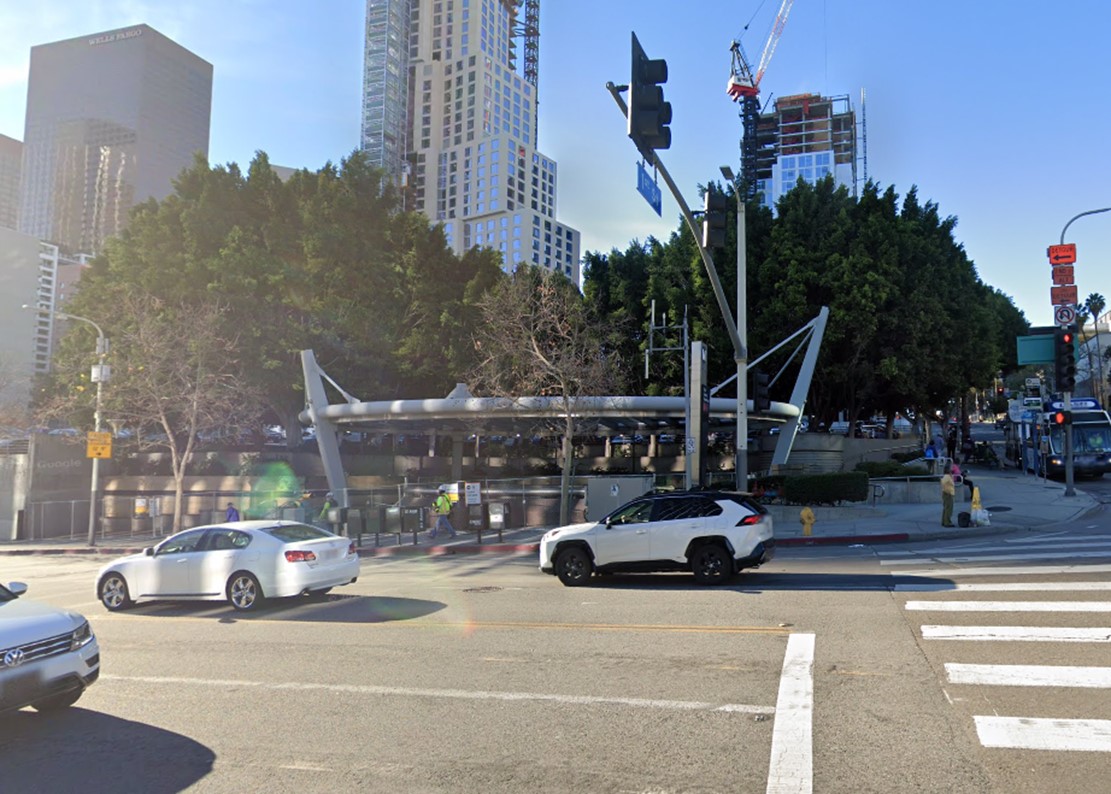
| (2021)* – Looking at the SW corner of Hill and 1st streets where today stands a Metro Station. |
| Historical Notes
The modern view shows a rebuilt corner. The earlier mix of hotels, service businesses, and open lots has been replaced by transit infrastructure and surrounding civic development. The Civic Center/Grand Park station now occupies this location, reflecting a shift from automobile-oriented uses to public transit. |
Then and Now
 |
|
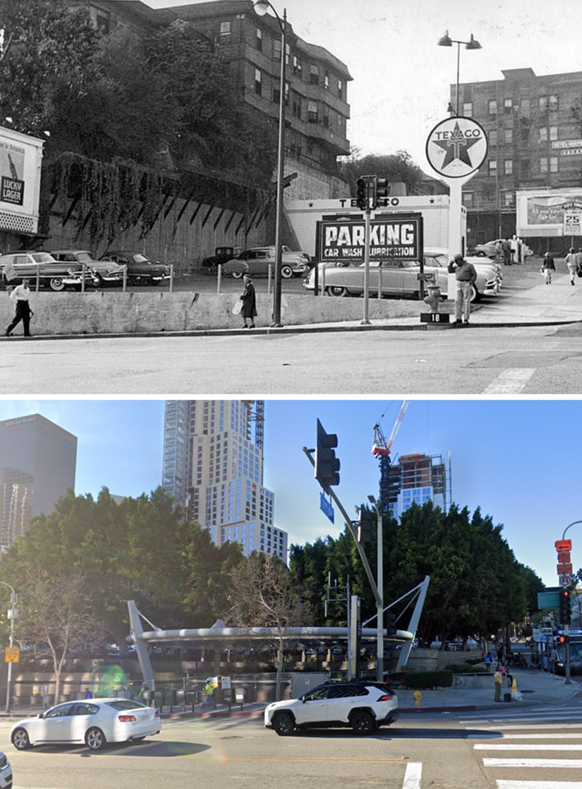
| (1953 vs 2021)* – Looking at the SW corner of Hill and 1st streets where today stands a Metro Station. Photo comparison by Jack Feldman. |
| Historical Notes
These images show how completely the corner has changed. In 1953, the site was defined by small hotels, service businesses, and partially cleared land. By 2021, those elements are gone. The area has been rebuilt as part of a larger civic and transit-oriented landscape. The comparison also reflects a return to underground transit at this location. Earlier tunnels once passed beneath this part of the hill, and today the subway again runs below the street. |
 |
|
| (1955)* – View looking west on 1st Street at Hill Street showing a Texaco service station at the SW corner with the El Moro Hotel above it. Further up 1st Street is the Hotel Gladden, SE corner of Olive and 1st. To the right is the construction site of the new Los Angeles County Courthouse. Photo by Palmer Conner |
| Historical Notes
This 1955 image captures a direct contrast. The El Moro Hotel and service station remain in place, while construction of the County Courthouse is underway nearby. The courthouse project marks the beginning of large-scale redevelopment in this part of Bunker Hill. Existing buildings continued in use even as the surrounding blocks were being prepared for major change. |
 |
|
| (2023)* – Looking west on 1st Street at Hill Street. |
| Historical Notes
The modern view shows a broad corridor shaped by civic buildings and open space. The earlier mix of hotels and service businesses has been replaced by larger structures and a more formal layout. This stretch of First Street now functions as part of the Civic Center, linking government buildings and public space. |
Then and Now
 |
|
| (1955 vs 2023)* – Looking west on 1st Street at Hill Street in DTLA. Photo comparison by Jack Feldman. |
| Historical Notes
This comparison highlights the change in scale and use along First Street. The earlier image shows a narrow corridor lined with low-rise buildings and local businesses. In the modern view, the street is wider and framed by civic structures and open space. The earlier pattern of neighborhood activity has been replaced by a setting defined by civic and institutional use. |
* * * * * |
From City Hall: The Transformation of the 1960s |
From the observation deck of City Hall, Bunker Hill appears as a broad rise just west of the Civic Center. For decades, this vantage point revealed a dense residential neighborhood. By 1960, much of that landscape had been cleared, leaving open ground where redevelopment would soon take place.Within a decade, the scene changed completely. The DWP General Office Building and the Dorothy Chandler Pavilion rose on land that had been cleared only a few years earlier, creating a new civic and cultural skyline. These images capture the shift from open terrain to a fully developed district. |
 |
|
| (ca. 1960)* - View looking northwest from City Hall toward Bunker Hill prior to construction of the GOB and Music Center. |
| Historical Notes
The 1960 image shows Bunker Hill near the end of its initial clearing phase. Much of the earlier residential fabric had been removed, leaving large areas of open land. The site that would later hold the General Office Building and the Music Center is visible here before construction began. |
 |
|
| (ca. 1970)* - View looking northwest from City Hall after construction of the GOB and Music Center. |
| Historical Notes
By 1970, the same vantage point reveals a completed phase of redevelopment. The DWP General Office Building and the Dorothy Chandler Pavilion now define the skyline. These structures established the civic and cultural character that continues to shape this part of downtown. |
Before and After
 |
|
| 1960 vs. 1970 - Photo comparison by Jack Feldman. |
| Historical Notes
These images illustrate the pace of change across Bunker Hill during the 1960s. In 1960, the hill consisted largely of cleared land with only limited remaining structures. By 1970, that open ground had been replaced by major civic buildings. The skyline seen from City Hall had been reshaped within a single decade. |
Before and After
 |
|
| 1960 vs. 1970 - Photo comparison by Jack Feldman. |
| Historical Notes
This second comparison offers a slightly different perspective. The earlier image shows a hillside in transition, while the later view presents a completed civic district. Together, the two views reinforce how quickly Bunker Hill was rebuilt within a single decade. |
* * * * * |
A Changing Downtown Skyline |
These aerial views trace the evolution of downtown Los Angeles across several decades. From above, the relationship between freeways, civic buildings, and neighborhoods becomes clear in a way that street-level images cannot show.In the 1950s, the city center remained largely low-rise, with Bunker Hill still standing as a dense residential district beside the Civic Center. Over time, that setting was cleared, graded, and rebuilt as a center of civic, cultural, and commercial activity. Together, these images show how the city’s physical form shifted from mid-century to the present. |
 |
|
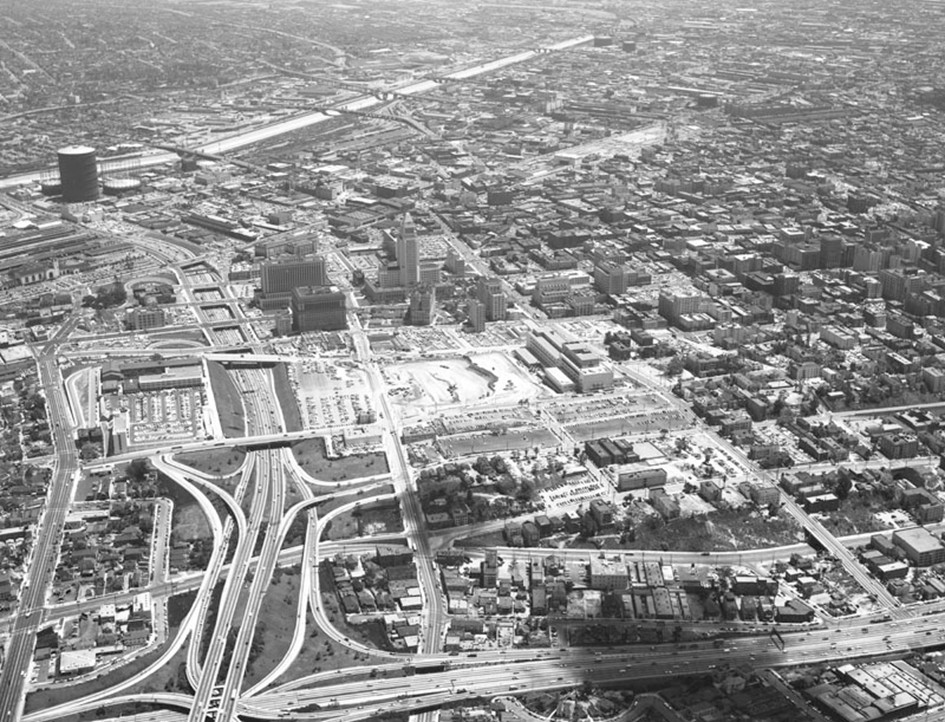
| (1957)* - Aerial view looking southeast across the Los Angeles Civic Center with Bunker Hill visible at lower right. The Hollywood Freeway (101) runs along the left, City Hall stands in the center, the Los Angeles River is seen near the top, and the Harbor Freeway (110) cuts across the bottom. The street extending from the bottom center toward the top is Temple Street. |
| Historical Notes
This 1957 aerial captures downtown at a key moment of change. The Hollywood Freeway, completed to downtown in 1954, and the Harbor Freeway, completed between 1951 and 1953, had established the transportation framework that would shape future growth. City Hall remains the dominant feature, surrounded by a largely low-rise setting. Bunker Hill, visible at lower right, still retains much of its residential character, though clearance was already underway. |
 |
|
| (2023)* - Contemporary aerial view looking southeast toward the Civic Center and Bunker Hill. |
| Historical Notes
The modern skyline reflects a fully developed downtown. Bunker Hill has been rebuilt as a district of civic buildings, cultural institutions, and office towers. City Hall remains visible but no longer dominates the skyline, now set within a denser urban core. The growth seen here reflects decades of continued construction beyond the initial redevelopment period. |
Then and Now
|
|
| (1957 vs 2023)* - Aerial view comparison looking southeast showing the changing skyline of the Civic Center and Bunker Hill. Photo comparison by Jack Feldman. |
| Historical Notes
This comparison highlights the shift from an open skyline to a dense urban center. In 1957, City Hall stands apart from its surroundings. By 2023, the skyline is filled with larger structures, and Bunker Hill has been completely rebuilt. The build-out of the hill extended over decades, with major additions continuing into the 21st century. |
 |
|
| (ca. 1960)* – Aerial view looking east toward Bunker Hill and the Los Angeles Civic Center. The flattened area on Bunker Hill at center left would later become the site of the Music Center and the Department of Water and Power Building. The Harbor Freeway runs across the foreground, while First Street cuts diagonally from lower left to upper right. |
| Historical Notes
By around 1960, the homes and apartments that once covered Bunker Hill had been cleared and the hill graded flat. The land was ready for what would come next. Within a few years, the Dorothy Chandler Pavilion opened in 1964, followed by the DWP Building in 1965. Together they established Bunker Hill as the new civic and cultural heart of downtown Los Angeles. |
 |
|
| (2022)* - Google Earth view showing Bunker Hill and the Civic Center. |
| Historical Notes
More than sixty years later, the same view shows a fully developed downtown. Bunker Hill is now home to the Walt Disney Concert Hall, The Broad, the Colburn School, and the Wells Fargo Center towers. The working-class residential district that once covered this hillside has been replaced by one of the most recognizable cultural and civic centers in the country. |
Then and Now
 |
|
| (1960 vs. 2022)* - Aerial view comparison looking east showing Bunker Hill and the Los Angeles Civic Center. Photo comparison by Jack Feldman. |
| Historical Notes
These images show the transformation from cleared land to a fully developed district. In 1960, Bunker Hill appears as an open site prepared for construction. By 2022, that same area is filled with major structures. The contrast also shows that while clearance occurred quickly, the build-out continued for many years. |
Then and Now
 |
|
| (1945 vs. 2022) - Aerial view over Bunker Hill looking east toward the Los Angeles Civic Center. Temple Street is on the left running away from the camera. |
| Historical Notes
From the same angle, the 1945 image shows Bunker Hill as it once was, filled with houses and dense residential blocks that stretched across the hillside. The 2022 view shows what replaced it. The old neighborhood is gone, and the Civic Center now occupies land that was once home to thousands of people. |
Then and Now
 |
|
| (1951 vs. 2022) - Aerial view looking down toward Bunker Hill. Photo comparison by Jack Feldman. |
| Historical Notes
In 1951, Bunker Hill remained a residential district with closely spaced buildings and active streets. By 2022, not a single structure from that period remains in this area. The terrain, street pattern, and uses have all been reconfigured. |
Before and After
|
|
|
|
| (1954 vs.1970)* - Photo comparison by Jack Feldman. |
| Historical Notes
This comparison captures the shift from the final years of the residential neighborhood to the early results of redevelopment. By 1970, major civic buildings had replaced most of the earlier structures. The transformation occurred in little more than a decade once redevelopment began in full. |
Then and Now
|
|
|
|
| (1954 vs. 2020)* - Photo comparison by Jack Feldman. |
| Historical Notes
This longer comparison highlights the lasting impact of redevelopment. The earlier view reflects the former residential landscape, while the modern image shows a fully developed civic and commercial district. The contrast also shows that change did not end with the first phase of construction, but continued over many decades. |
* * * * * |
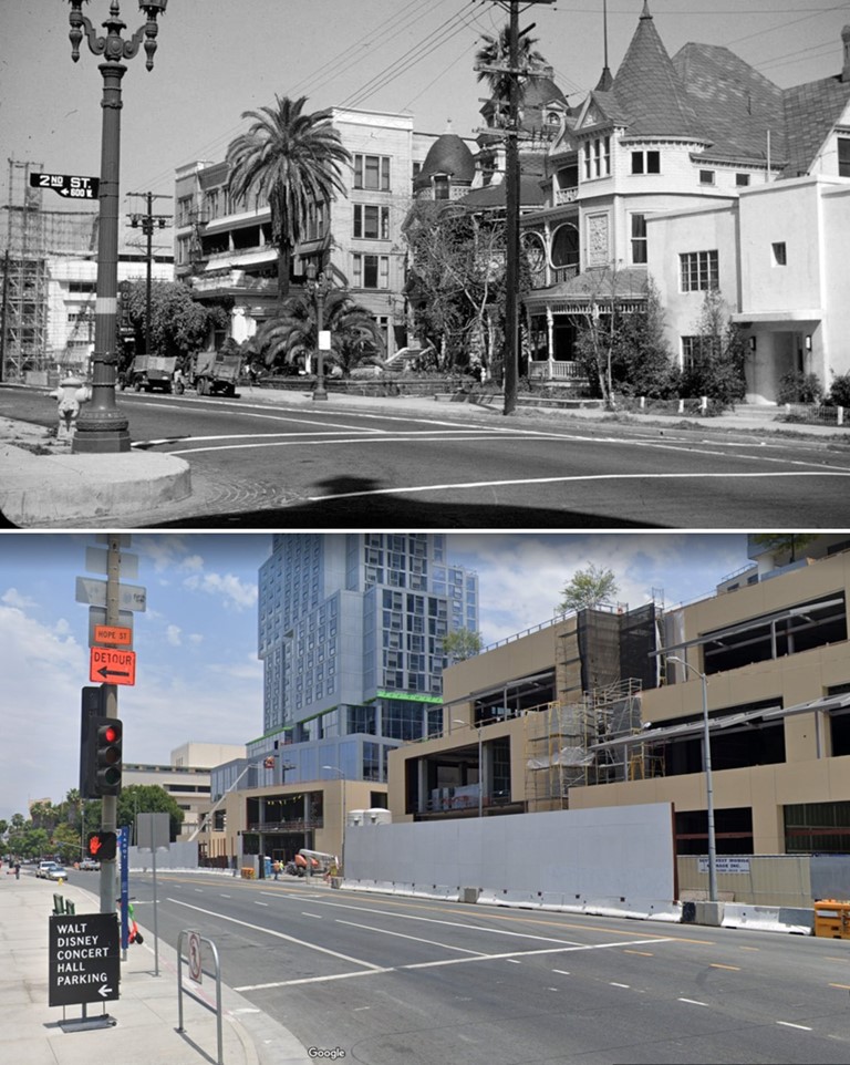
2nd and Olive Streets |
The intersection of Second and Olive Streets was one of the most intact and representative corners on Bunker Hill in its final years. Within a single block stood many of the neighborhood’s defining elements: a Victorian residence, one of its oldest hotels, small ground-floor businesses, and the dual-lamp streetlights that once lined the hill.The Argyle Hotel, located at the northeast corner, had been a fixture since the 1880s. Operating under new management by 1887, it offered more than sixty rooms and served as a social center before settling into use as a residential hotel. Across the street, the Koster House at 507 West Second Street remained one of the more refined Queen Anne residences from the neighborhood’s earlier period.These images are valuable for their detail. Gasoline pumps at the curb, storefront uses within older buildings, and the gradual appearance of parking lots reflect how daily life adapted before redevelopment erased it. The photographs record a neighborhood in its final stage of use. |
 |
|
| (ca. 1950)* - View looking northeast from south side of 2nd Street between Olive Street and Grand Avenue. Shows nearby houses and apartments, with downtown buildings and City Hall in the distance. |
| Historical Notes
The Koster House at 507 West Second Street appears at left, a Queen Anne residence dating to the late 19th century. Its form reflects the period when Bunker Hill was one of the city's most desirable residential districts. Across the street, the Argyle Hotel anchors the corner at Olive and Second. By 1950, it had operated for more than sixty years, a quiet presence at one of the neighborhood's most photographed intersections. |
.jpg) |
|
| (ca. 1950)* - View looking east at northeast corner of Second and Olive Streets. Automobiles are parked in the foreground next to two gasoline pumps and on Olive Street. The mansared-roofed Argyle Hotel/Apartments are located at the corner, near other Victorian-era houses. City Hall tower is visible in the left distance. |
| Historical Notes
The Argyle Hotel, built in the 1880s, was advertising dozens of rooms by the late 19th century and remained active into the mid-20th century. By this time, its ground floor housed a grocery and laundry serving nearby residents. Gasoline pumps at the curb indicate a later layer of use. Automobile-related services had begun to occupy small parcels throughout the neighborhood, often on sites cleared ahead of full redevelopment. |
.jpg) |
|
| (ca. 1950)* - Looking at the northeast corner of 2nd and Olive Streets showing the mansard-roofed Argyle Hotel/Apartments, containing a laundry and a grocery. City Hall is seen at right. |
| Historical Notes
This closer view presents the Argyle in its final configuration, with residential space above and commercial tenants below. Such mixed use allowed buildings to remain viable as the neighborhood's population changed. Its mansard roof gives the structure a Second Empire profile, a style that set it apart within the area. The building was demolished in the 1960s as redevelopment advanced across the hill. |
 |
|
| (1955)* – City Hall as seen from the south side of 2nd Street looking over the Olive Street roofline with light in eastern sky peeping through low overcast.; Caption slip reads: Photographer: Wesselmann. Date: 1955-03-11 |
Historical NotesThis photograph by Wesselmann, taken on March 11, 1955, emphasizes the relationship between Bunker Hill and the Civic Center. City Hall stands beyond the lower rooflines, illustrating the contrast between the residential district and the city's administrative core. The streetlight in the foreground is a Union Metal UM-1747 "Pacific" model with dual lanterns, installed widely across Bunker Hill. Nearly all were removed during redevelopment, with one example remaining on Olive Street as of 2021. Click HERE to see more 'Pacific' UM 1747 dual-lamp streetlights (Contemporary Views) |
 |
|
| (ca. 1965)* – A decorative dual-lamp ‘Pacific’ (UM-1747) stands in front of the Koster House, a Queen Anne style residence at 507 W. Second Street on Bunker Hill. The Los Angeles Times Building, and City Hall are seen in the distance on the right. Also seen is a parking lot where the Argyle Hotel once stood. |
| Historical Notes
By the mid-1960s, this block had entered a new phase. The Argyle Hotel had been demolished, its site replaced by a parking lot — a common first use of cleared land throughout Bunker Hill before permanent construction began. The Koster House remains standing in this view, though the surrounding neighborhood had thinned considerably. The contrast between the surviving residence and the cleared land beside it marks the transition from residential district to redevelopment site. |
* * * * * |
2nd Street (Between Grand Avenue and Olive Street) |
Chaspeak Apartments and the Transformation of Bunker Hill |
The south side of West Second Street between Grand Avenue and Olive Street once held a row of Victorian apartment buildings that reflected Bunker Hill’s residential past. The most distinctive was the Chaspeak Apartments at 512 West Second Street, with its square bays, twin towers, and arched entrance. Nearby, the building at 508 added angled bays and a porch to a streetscape that still carried the character of an earlier Los Angeles.By 1950, when photographer Arnold Hylen captured these views, Bunker Hill had already changed. Grand homes had been divided into apartments and rooming houses, creating a dense neighborhood of working residents, retirees, and newcomers. Within two decades, this entire block would be cleared as part of the city’s redevelopment of Bunker Hill. Today, the Colburn School stands on this site, representing a very different chapter in the area’s history. |
 |
|
| (1950)* – A man walks downhill past two Victorian apartment buildings. The structure at left features angled bays and a front porch, while the Chaspeak Apartments at right display square bays, twin towers, and an ornate entrance arch. Photo by Arnold Hylen. |
| Historical Notes
The Chaspeak Apartments at 512 West Second Street became a familiar presence in Hollywood films. The building appeared in Somewhere in the Night, directed by Joseph L. Mankiewicz, and later in The Days of Wine and Roses. Its steep setting and layered architecture made it a natural backdrop for stories set in Los Angeles’ older neighborhoods. By the mid-20th century, buildings like these reflected the changing character of Bunker Hill. Once home to wealthy residents, the area had become a dense working neighborhood filled with apartment houses and rooming establishments. Residents included laborers, retirees, and recent arrivals, giving the district a lived-in, textured quality that filmmakers often sought to capture. |
.jpg) |
|
| (1950)* – A closer view of the Chaspeak Apartments highlights the square bays, twin towers, and rounded entrance arch. Photographer Arnold Hylen can be seen walking in the foreground. |
| Historical Notes
Bunker Hill began in the late 19th century as one of Los Angeles’ most desirable residential areas. Large Victorian homes lined its streets, taking advantage of the hill’s elevation and views. The opening of Angels Flight in 1901 connected the neighborhood directly to downtown and reinforced its appeal. Over time, however, newer neighborhoods drew wealthier residents away. By the 1920s and 1930s, many of the older homes had been converted into apartments and rooming houses. Buildings like the Chaspeak became part of a dense and diverse urban environment that defined Bunker Hill’s character until redevelopment began in the early 1960s. |
 |
|
| (2024)* – The south side of West Second Street today, now occupied by the Colburn School. Photo comparison by Jack Feldman. |
| Historical Notes
The Colburn School, founded in 1950, has grown into one of the leading performing arts institutions in the United States. Its campus on Bunker Hill places it at the center of Los Angeles’ cultural district, near the Walt Disney Concert Hall. The transformation of this site reflects the broader redevelopment of Bunker Hill, where a once residential neighborhood was cleared and replaced with office towers, public spaces, and cultural institutions. While the Victorian buildings are gone, their presence remains part of the visual and historical record of the area. |
Then and Now
 |
|
| (1950 vs. 2024)* – The Chaspeak Apartments at 512 West Second Street in 1950, compared with the same location today, now occupied by the Colburn School. Photo comparison by Jack Feldman. |
| Historical Notes
The transformation of this block from Victorian apartment buildings to a major performing arts campus took place within a single generation. The Chaspeak Apartments and neighboring structures were removed during the Bunker Hill redevelopment of the 1960s. More than half a century of residential life on this stretch of Second Street came to an end in just a few years. |
* * * * * |
Grand Avenue & 2nd Street |
The corner of Grand Avenue and 2nd Street was once home to two of Bunker Hill's most distinctive Victorian-era buildings, the Melrose Hotel and the Hotel Richelieu. Built in the late 19th century, both reflect a time when the hill was lined with large homes for Los Angeles' early residents.By the mid-20th century, these buildings had been converted into boarding houses and hotel apartments, serving a dense and changing population. Within a few years, both would be demolished as part of the Bunker Hill redevelopment. Today, the site is occupied by The Grand. |
.jpg) |
|
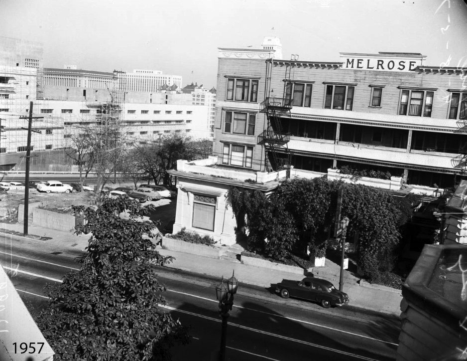
| (1957)* – Melrose and Richelieu Hotels, Grand Avenue at 2nd Street. View from the corner of 2nd Street and Grand Avenue showing the Richelieu and Melrose Hotels shortly before their demolition. |
| Historical Notes
The Hotel Richelieu began as a private residence built in 1888 for Robert Larkins. By the early 1890s, it had been converted into a boarding house, reflecting the shift of Bunker Hill from an exclusive residential district into a more densely populated neighborhood. The building was known for its decorative shingles, gables, and wide porches. The Melrose Hotel followed a similar path. Originally constructed in 1881 as a Victorian mansion, it was later expanded and adapted into a hotel apartment complex. Together, the Melrose and Richelieu formed a prominent part of the Grand Avenue streetscape. |
 |
|
| (1957)* - Melrose Hotel and Hotel Richelieu on the east side of Grand Avenue, just north of 2nd Street. Photo by George Mann, courtesy of Dianne Woods and the George Mann Archives. |
| Historical Notes
By the 1950s, both buildings were operating as hotel apartments. Once part of an upscale residential district, the area had evolved into a neighborhood of rooming houses and long-term residents. Their worn but recognizable appearance made them visually striking, even as redevelopment plans took shape. The City of Los Angeles began clearing Bunker Hill in the late 1950s and early 1960s, targeting older structures like these for demolition. The Richelieu was removed shortly before the Melrose in 1957. |
Then and Now
 |
|
| (1957 vs. 2021)* - Looking north on Grand Avenue at 2nd Street, showing The Grand LA development, which includes a 45-story residential tower and the 28-story Conrad Los Angeles Hotel, now standing where the Melrose and Richelieu once stood. Photo comparison by Jack Feldman. |
| Historical Notes
The transformation of this corner reflects the broader redevelopment of Bunker Hill. Where Victorian hotels once stood, the site is now occupied by The Grand LA, which includes a residential tower and the Conrad Los Angeles. This change replaced a residential neighborhood with a district of high-rise buildings, cultural institutions, and public spaces. While the Melrose and Richelieu are gone, photographs like these preserve the character of the neighborhood that once defined Bunker Hill. |
 |
|
| (1957)* - One of the last photographs showing the Melrose Hotel annex (at 120 S. Grand), the original Melrose building (at 130), and a partial view of the Richelieu Hotel (at 142). Photo by George Mann, courtesy of Dianne Woods and the George Mann Archives. |
| Historical Notes
This view captures the final years of the Melrose and Richelieu on Bunker Hill. The buildings stood on the east side of Grand Avenue just north of 2nd Street, forming a cluster of late 19th-century architecture that had survived into the automobile era. Despite their architectural character, these structures were removed as part of the city's urban renewal program, marking the end of a long-standing residential presence on this block. More history and images of the Melrose and Richelieu Hotels are available HERE. |
 |
|
| (1957)* – Long shot of the Melrose Hotel, to be torn down after 75 years, with the City Hall tower visible in the background. The view is from the future site of the Walt Disney Concert Hall. Photo date: April 8, 1957. |
| Historical Notes
This photograph, taken just days before demolition began, places the Melrose Hotel within the wider downtown landscape. City Hall, completed in 1928, rises in the background — a reminder of how much the city had grown since the Melrose was built as a Victorian mansion in 1881. The vantage point from which this photograph was taken would eventually become the site of the Walt Disney Concert Hall, which opened in 2003. The two structures represent different chapters of the same neighborhood: one shaped by the residential character of Victorian Bunker Hill, the other by the cultural redevelopment that followed. |
Before and After
.jpg) |
||
.jpg) |
| Historical Notes
These images show the scale of change that came to this corner over six decades. The Victorian streetscape that defined Bunker Hill for more than seventy years gave way to a modern urban campus of towers, plazas, and cultural venues. The Bunker Hill redevelopment, which unfolded across the 1960s and beyond, was one of the most significant urban renewal efforts in Los Angeles history. What replaced it was planned at a civic scale — and images like these offer the clearest measure of what was lost in the process. |
Then and Now
 |
|
| (1957 vs. 2021) - Looking toward the east side of Grand Avenue between 1st and 2nd streets, where the Melrose and Richelieu Hotels once stood. Photo comparison by Jack Feldman. |
| Historical Notes
This view captures a longer stretch of Grand Avenue and gives a sense of how fully the Victorian streetscape once filled this block. The Melrose and Richelieu were among the most architecturally prominent buildings remaining on Bunker Hill by the mid-20th century. Today the same view is defined by the towers and open spaces of the modern civic core. The contrast between the two images makes clear that the redevelopment of Bunker Hill was not simply a change in buildings — it was a transformation of the entire character of the neighborhood. |
* * * * * |
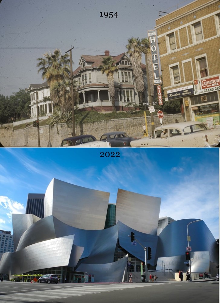
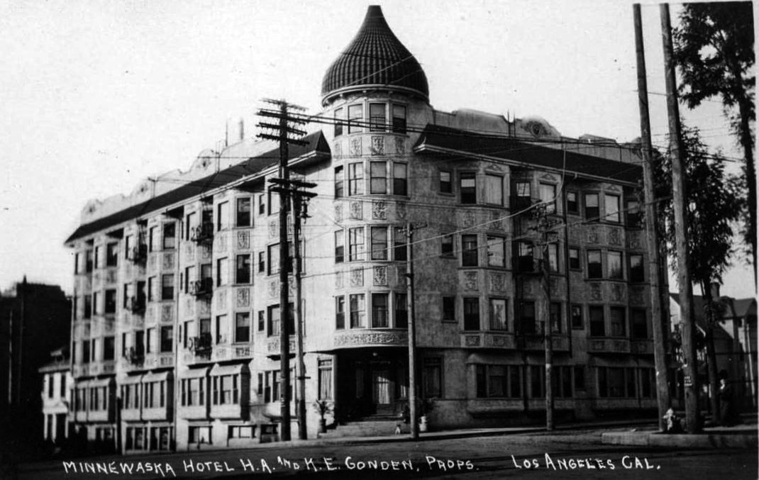
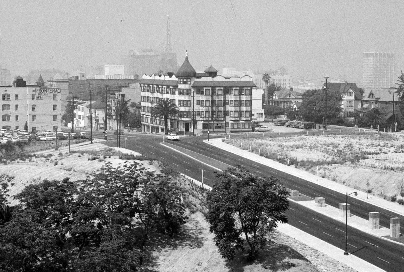
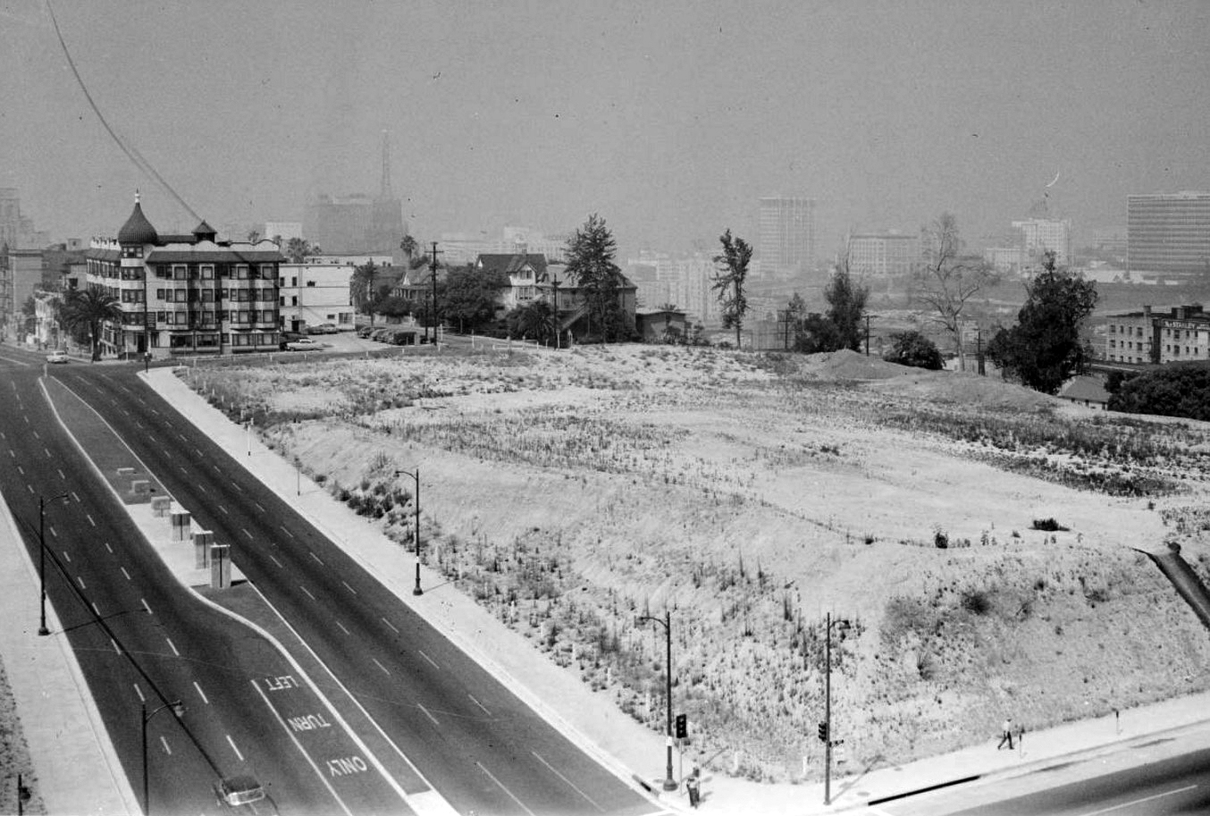
Dome Hotel and Apartments (aka Minnewaska Hotel) |
The Minnewaska Hotel opened in 1903 as one of Bunker Hill’s most distinctive buildings. Its four stories and signature dome set it apart from nearby Victorian homes and smaller lodging houses, establishing the corner of 2nd Street and Grand Avenue as a prominent address.Within a few years, the name was shortened to the Dome. The change reflected a broader shift in use—from a formally named hotel to a more practical residential building serving longer-term tenants.By the mid 20th century, it had outlasted most of its surroundings. As redevelopment cleared entire blocks, it stood increasingly isolated. A fire in July 1964 ended its long run, and the site remained vacant for decades before its eventual redevelopment. |
 |
|
| (ca. 1905)* – View of the Minnewaska Hotel with its distinctive dome at the southwest corner of 2nd Street and Grand Avenue, later renamed the Dome Hotel and Apartments. |
| Historical Notes
Completed in 1903, the Minnewaska opened as a four story hotel with roughly 125 rooms. Its spiral dome made it one of the most recognizable structures on Bunker Hill and a visual anchor along Grand Avenue. Construction featured heavy diagonal framing with steel lath and a cream tinted plaster finish. Interiors included private baths, marble washstands, steam heat, and electric bells—modern amenities that set it apart from many nearby residences. |
 |
|
| (1960)* – View of the Dome Hotel and Apartments, with the Rihfield Oil Company Building in the background and the future site of Walt Disney Concert Hall to the right. |
| Historical Notes
By 1960, it functioned entirely as apartments. The surrounding area had entered active clearance under the city’s redevelopment program, leaving large sections of open land. The Richfield Building, completed in 1929 and clad in black and gold terra cotta, still dominated the skyline but would be demolished in 1969. The cleared parcel to the right remained unused for decades before becoming the site of the Walt Disney Concert Hall. |
 |
|
| (1960)* – Looking southwest from the L.A. County Courthouse at 1st and Grand, with the Dome Apartments visible beyond a cleared lot. This will become the site of the Walt Disney Concert Hall (completed in 2003). |
| Historical Notes
This perspective places the Dome within a landscape already stripped of much of its earlier fabric. Blocks once filled with homes and small hotels had been removed, leaving wide gaps between remaining structures. It continued to house residents, yet its surroundings no longer functioned as a cohesive neighborhood. The contrast between occupied structure and open ground reflects the staged nature of redevelopment across Bunker Hill. |
 |
|
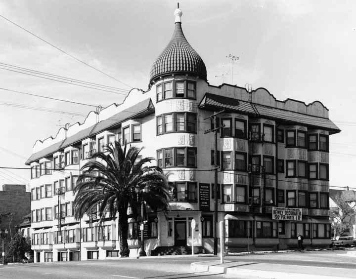
| (ca 1963)* – Profile of the Dome Apartments, advertising “Newly Decorated, $50 Per Month & Up. |
| Historical Notes
By the early 1960s, the property operated as low cost housing. Monthly rents starting at $50 reflect both its age and reduced demand for the area. Many remaining residents were older or of limited means, holding on as the neighborhood around them was dismantled. Efforts to attract tenants with updated interiors point to attempts to maintain occupancy during a period of steady decline. |
 |
|
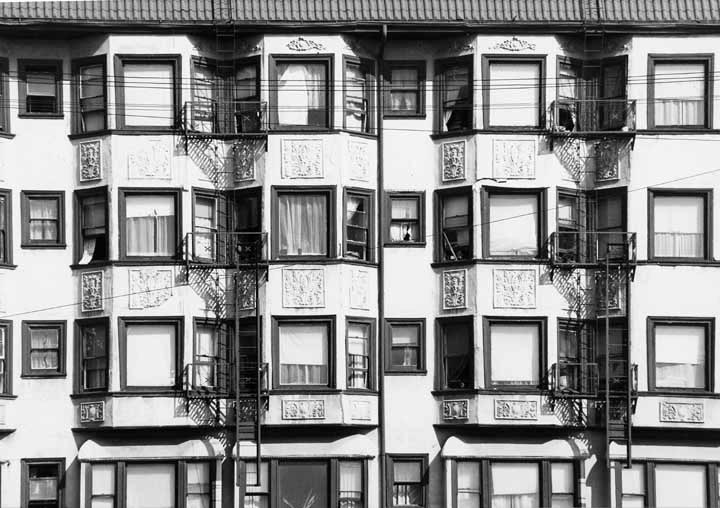
| (1960s)* – Close-up of the Dome Apartments façade showing plaster finish and fire escapes. |
| Historical Notes
The exterior showed clear wear after decades of exposure. The original cream finish had faded, while added fire escapes reflected evolving safety requirements. An open interior stairwell and light court created a continuous vertical space. This design later allowed fire to move rapidly through the building. |
 |
|
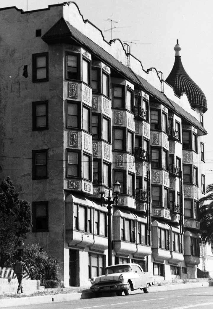
| (1964)* – Profile of the Dome Apartments at 2nd and Grand, taken shortly before the fire that destroyed the building. |
| Historical Notes
On July 25, 1964, a fire moved quickly through the building, killing one resident and injuring several others. The open stairwell acted as a vertical channel, accelerating the spread of flames. The cause was never conclusively determined, though some observers later suggested the loss aligned with redevelopment pressures already reshaping Bunker Hill. It was demolished later that year, and the corner was converted to surface parking. |
Then and Now
 |
|
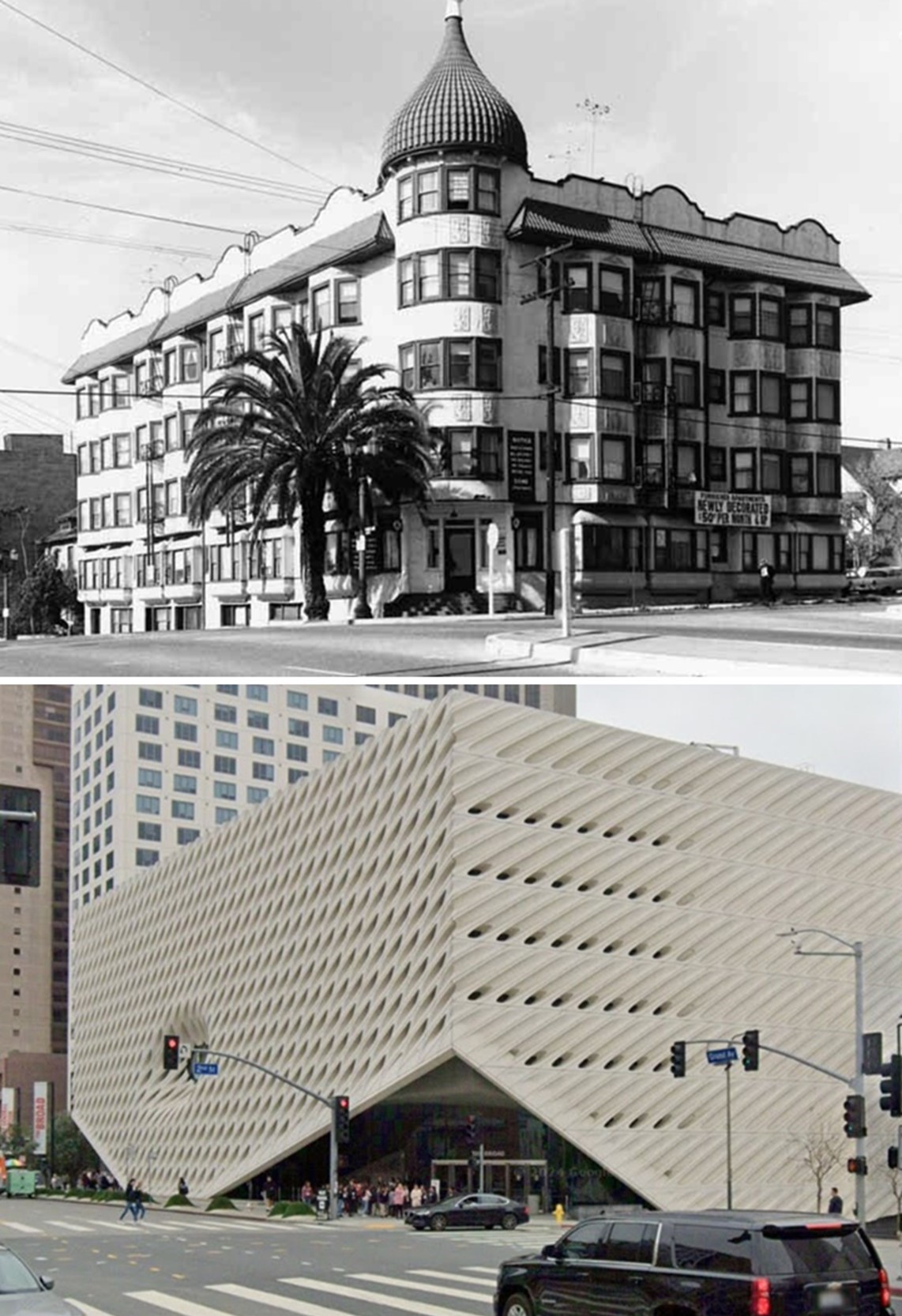
| (1963 vs. 2024)* - Looking at the southwest corner of Grand Avenue and 2nd Street, where the Dome Apartments once stood, today the site of The Broad Contemporary Art Museum, also known as The Broad. Photo comparison by Jack Feldman. |
| Historical Notes
Following demolition, the site remained a parking lot for nearly fifty years. This long gap reflects the uneven pace of redevelopment on Bunker Hill, where cleared parcels often sat unused for decades. Construction of The Broad began in 2014, and the museum opened in 2015. Its “veil and vault” design—an outer lattice wrapping a solid inner core—stands in sharp contrast to the earlier structure, marking the final phase in this corner’s transformation. |
* * * * * |
Grand Avenue and First Street |
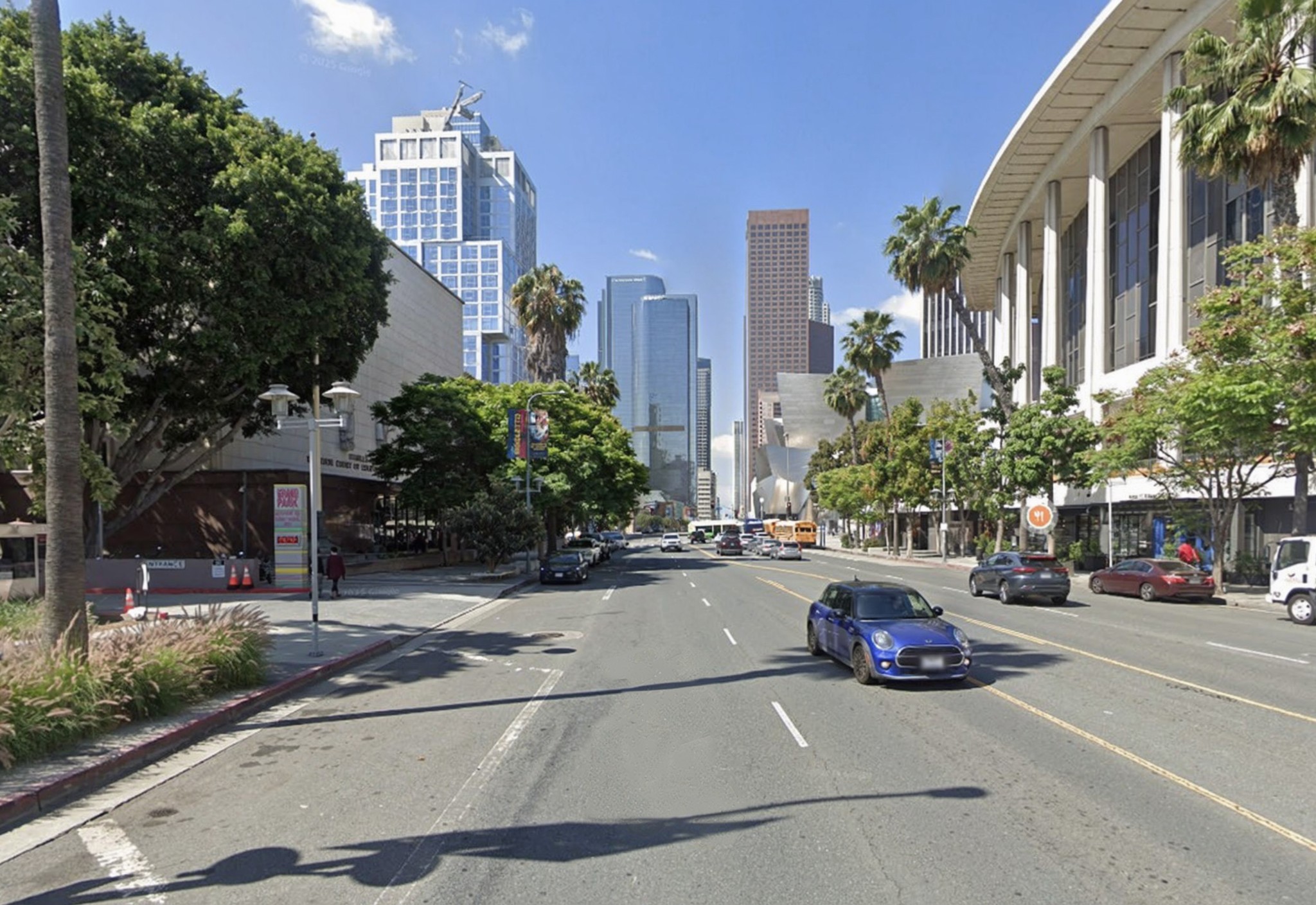
Few intersections in Los Angeles show the city’s transformation as clearly as Grand Avenue at First Street. What began as the edge of old Bunker Hill—lined with Victorian residences and early infrastructure—evolved into a civic corridor anchored by courts, culture, and architecture. These views capture that shift from a working downtown to a world stage for the arts. |
 |
|
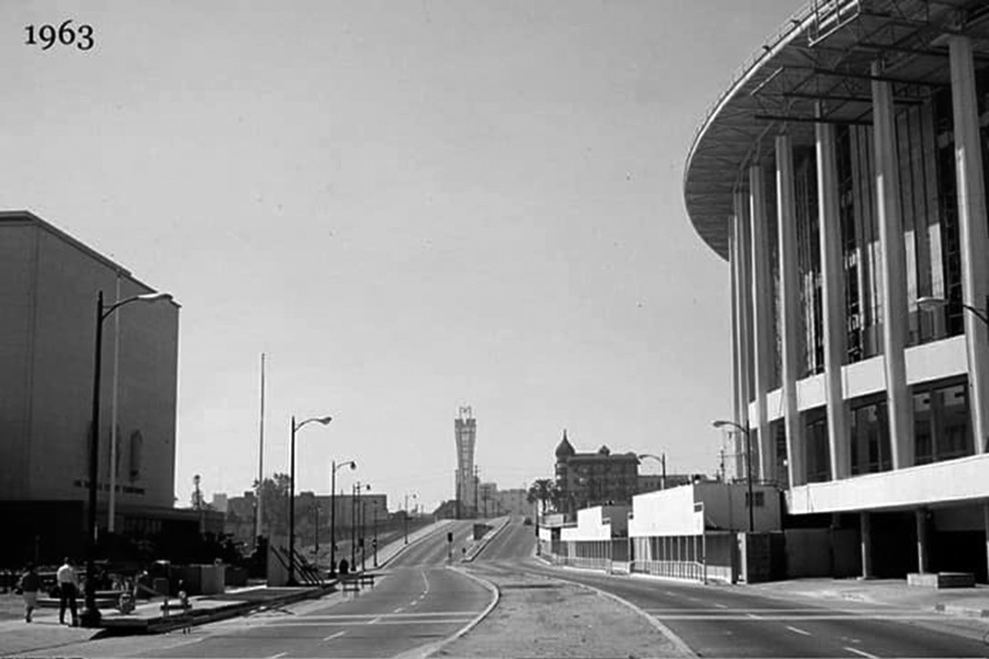
| (1963)* – Looking south on Grand Avenue toward First Street. At right, the Dorothy Chandler Pavilion rises as it nears completion, signaling the arrival of the Music Center. At left stands the Los Angeles County Courthouse. In the distance, the AT&T Madison Complex and its microwave tower share the skyline with the aging Dome Apartments on Bunker Hill. |
Historical Notes
|
 |
|
| (2025)* - Looking south on Grand Avenue toward First Street. The view is now dominated by the Walt Disney Concert Hall (2003) and The Grand LA, Frank Gehry’s mixed-use complex completed in the 2020s. At Grand and 2nd, The Broad Museum (2015) now occupies the site of the old Dome Apartments. The Music Center Plaza, reopened in 2019 after a major renovation, ties the campus together as an active public square. |
| Historical Notes
Walt Disney Concert Hall, designed by Frank Gehry, opened in 2003 and completed the Music Center’s four venue complex. The Broad, designed by Diller Scofidio + Renfro, opened in 2015 at 221 South Grand Avenue on the former site of the Dome Hotel and Apartments. The Grand LA introduced residential, hotel, and retail uses to the corridor, reinforcing Grand Avenue’s role as a mixed use cultural district. The Music Center Plaza was redesigned in 2019, expanding its capacity and transforming it into a central civic space for events and public use. |
Then and Now
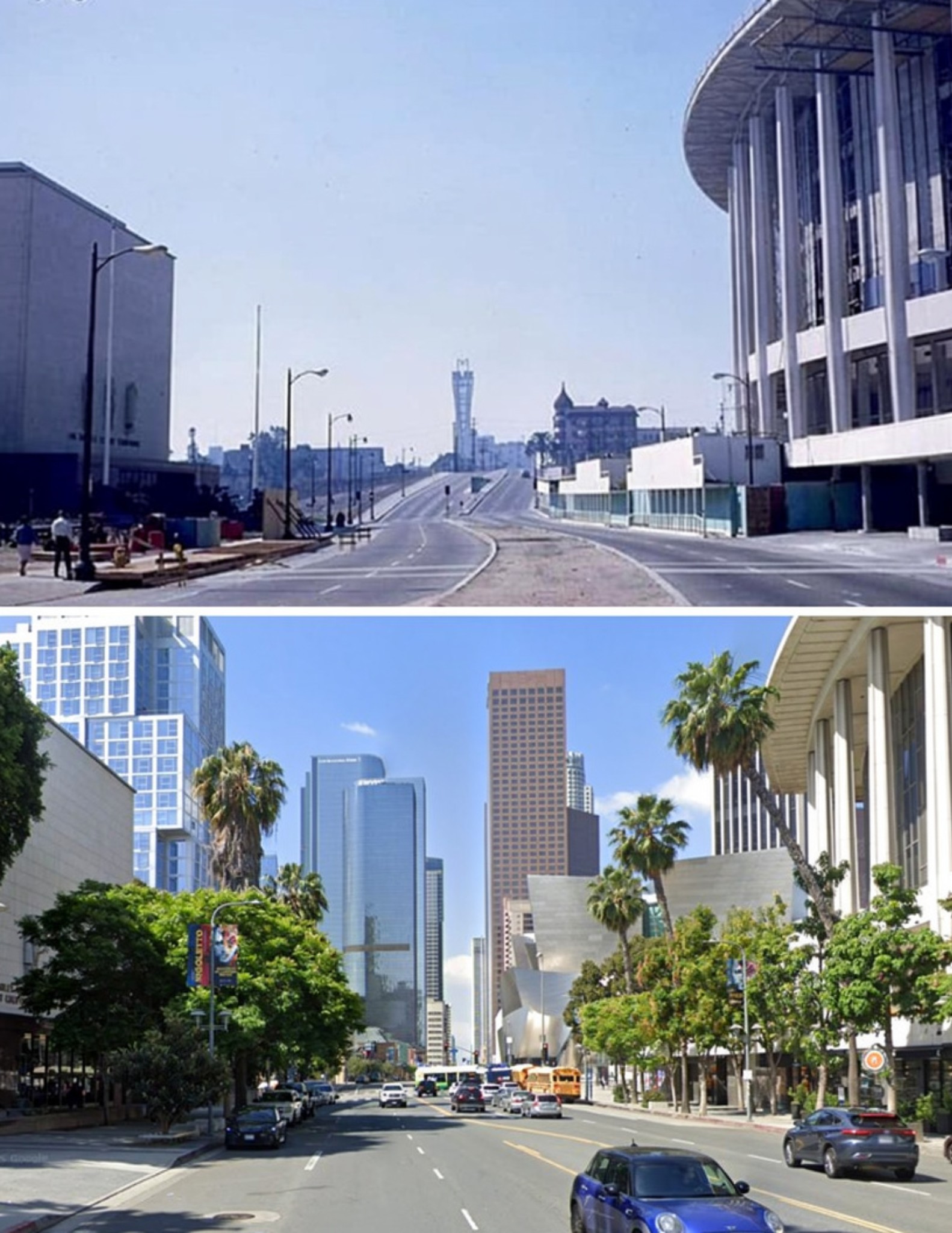 |
|
| (1963 vs. 2025)* - Looking south on Grand Avenue toward First Street. In 1963, the skyline reflects a city in mid-transition, where civic buildings and telecommunications infrastructure marked the edge of Bunker Hill. By 2025, the same view has become a cultural corridor defined by architecture, performance, and public space. Photo comparison by Jack Feldman. |
| Historical Notes
The redevelopment of Bunker Hill in the 1960s and 1970s replaced a dense residential neighborhood with civic institutions and cultural landmarks. The AT&T Madison Complex represents an era when long distance communication relied on centralized switching and microwave transmission. The corner at Grand and 2nd has shifted from residential lodging to a major cultural destination, now home to The Broad. The redesign of the Music Center Plaza reflects a broader effort to reconnect downtown spaces with the public and encourage everyday use. |
* * * * * |
Grand Avenue and Temple Street |
Few intersections reflect the early character of civic Los Angeles as clearly as Grand Avenue and Temple Street. Once lined with small hotels, markets, and service buildings, this corner served a growing downtown just north of Bunker Hill. By the 1960s, the entire block was cleared and replaced by the Music Center, transforming the area into one of the city’s leading cultural destinations. |
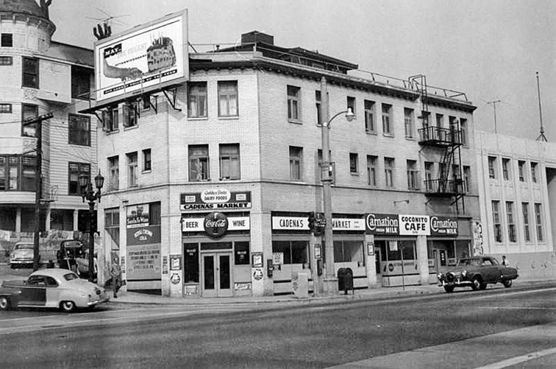 |
|
| (ca. 1955)* – Looking southwest across Temple Street in the foreground and Grand Avenue at left. The Cadena Hotel stands at 600 Temple Street, with Cadena’s Market at street level. On the right is an Art Deco building at 610–614 Temple Street, home to the Federation of Jewish Welfare Organizations. At the far left, a portion of the St. Angelo Hotel is visible. |
| Historical Notes
The Cadena Hotel occupied the southwest corner of Grand and Temple and included a neighborhood market at street level, serving local residents and workers. The Federation Building at 610–614 Temple Street housed the Federation of Jewish Welfare Organizations, which coordinated charitable and social services across Los Angeles. The St. Angelo Hotel, built in 1887, was one of the last Victorian era buildings on this block. It later declined into a rooming house and was vacated in 1956 before demolition. By the early 1960s, this entire block was cleared as part of the Bunker Hill redevelopment that made way for the Music Center. |
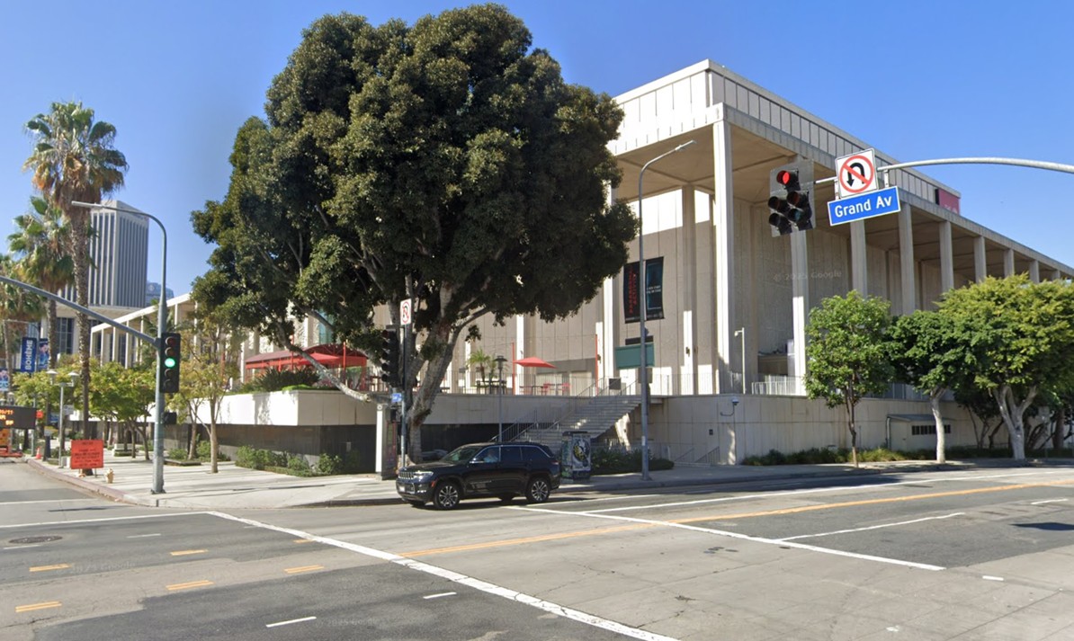 |
|
| (2025)* - Looking at the southwest corner of Temple Street and Grand Avenue. The Ahmanson Theatre now stands on the site of the former Cadena Hotel. |
| Historical Notes
The Ahmanson Theatre opened on April 12, 1967, as part of the Music Center’s second phase, following the Dorothy Chandler Pavilion. The theatre was funded by Howard F. Ahmanson Sr. and named for his wife, Caroline Leonetti Ahmanson. Designed by architect Welton Becket, the building is part of the same design program that shaped the early Music Center campus. A major renovation in 1994 improved acoustics and sightlines and allowed for flexible seating depending on the production. |
Then and Now (Grand and Temple Street, SW Corner)
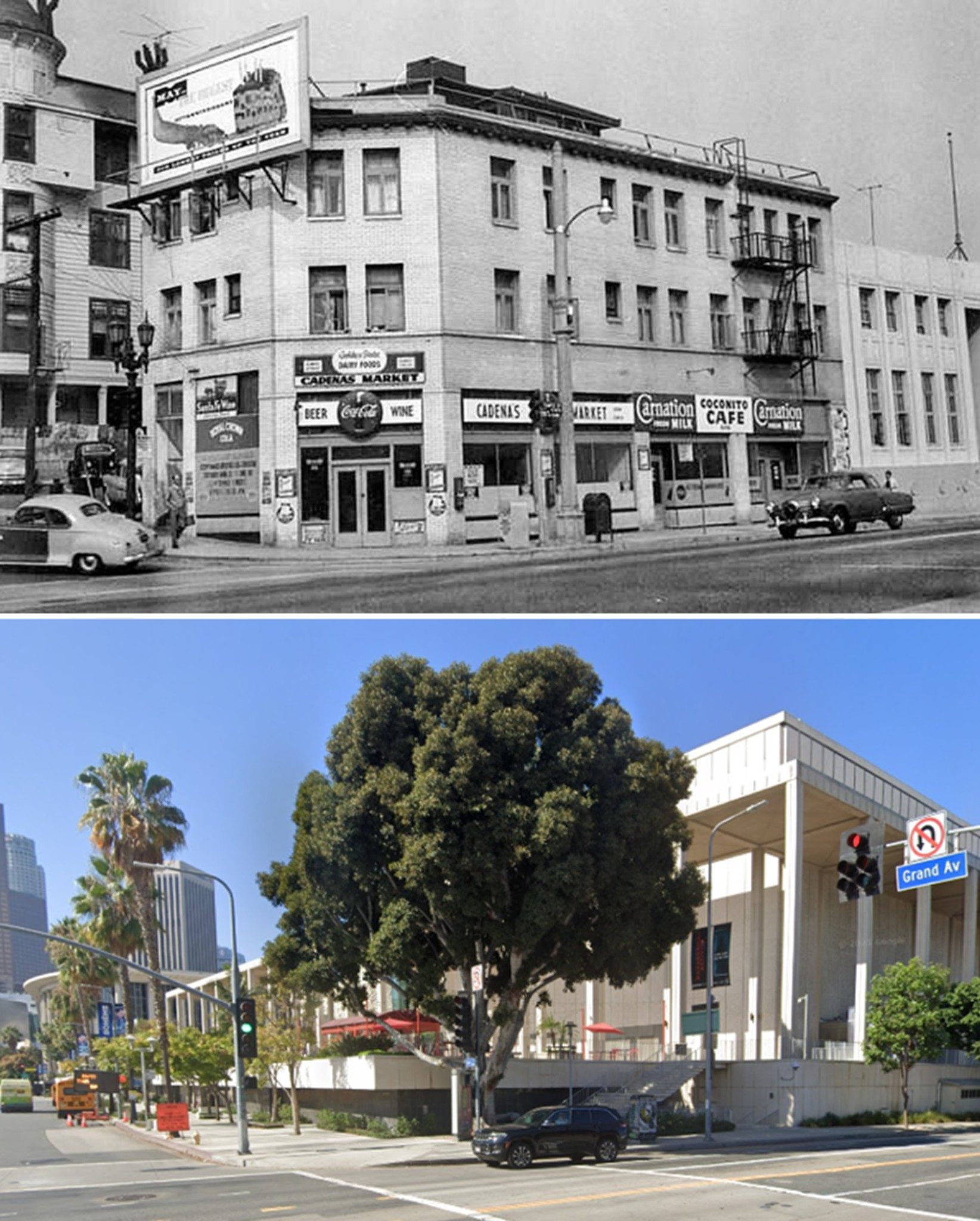 |
|
| (1955 vs. 2025)* – Then and Now view of the southwest corner of Temple Street and Grand Avenue. What was once a modest hotel and neighborhood market is now part of a major performing arts complex anchored by the Ahmanson Theatre. Photo comparison by Jack Feldman. |
| Historical Notes
This corner was once part of a mixed use block with lodging, retail, and community services on the edge of Bunker Hill. The removal of the St. Angelo Hotel marked the end of one of the area’s longest standing Victorian era buildings. The Music Center development in the 1960s reshaped this part of downtown into a center for culture and performance. Today, the Ahmanson Theatre hosts major productions and draws audiences from across the region to a site that once served everyday neighborhood needs. |
* * * * * |
Then and Now (Grand and 1st Street, SW Corner) |
This comparison captures a major transformation on Bunker Hill. The southwest corner of Grand Avenue and 1st Street once formed part of a compact district of housing and small businesses that supported daily neighborhood life.During the early 1960s, redevelopment cleared the block. Regrading lowered the original street level and removed much of the earlier terrain.For nearly forty years, the parcel remained largely vacant. Today, it forms part of a major cultural complex, reflecting a complete shift in use and scale. |
.jpg) |
|
| (1954 vs. 2022)* – View looking toward the Southwest corner of Grand Avenue and 1st Street...present site of the Disney Concert Hall. |
| Historical Notes In 1954, this corner held small residential buildings and ground-level businesses. The nearby Grand Central Hotel contributed to a mix of housing and local commerce typical of Bunker Hill at that time. Clearance followed in the early 1960s, and the site remained empty for nearly four decades—a gap that reflects how unevenly redevelopment unfolded across Bunker Hill. Construction of the Walt Disney Concert Hall, completed in 2003, transformed the long-vacant parcel into a major cultural landmark. |
* * * * * |
Flower and 1st Street |
The southwest corner of 1st and Flower Streets shows Bunker Hill near the end of its residential period. Photographs taken in 1955 by Arnold Hylen document a group of Victorian-era apartment buildings still standing and occupied.Flower Street marked the western edge of the hill's most densely built area. Structures here began as single-family homes in the late 19th century before being divided into apartments and rooming houses serving working-class and lower-income tenants.Within a decade, the site was cleared. It now serves as the entry to Bunker Hill Tower and the Promenade West Condominiums, reflecting a complete change in land use. |
.jpg) |
|
| (1955)* - A view of Victorian-era apartment houses on the southwest corner of 1st and Flower Streets in Bunker Hill. Today, this site serves as the entryway to Bunker Hill Tower and the Promenade West Condominiums, directly across the street from the DWP building. Photo by Arnold Hylen. |
| Historical Notes
By the mid-1950s, many Bunker Hill buildings had shifted from single-family use to multi-unit housing. The area served working-class and lower-income residents, including elderly tenants and others with limited options elsewhere in the city. These buildings illustrate that transition. Despite visible wear, they remained occupied as redevelopment plans advanced, housing a community that would be displaced within a few years. |
.jpg) |
|
| (1955)* - Closer view of the Victorian-era apartment building at southwest corner of First and Flower Streets on Bunker Hill. Photo by Arnold Hylen. |
| Historical Notes
Architectural features common to late 19th-century construction are visible here, including wood framing, bay windows, and decorative trim. Many such buildings dated to the 1880s and 1890s, when Bunker Hill ranked among the city's most desirable residential areas. By the 1950s, these structures had been subdivided into smaller units and their condition had declined. Original design elements remained visible, marking them as products of an earlier period. |
 |
|
| (1955)* – A close-up of the dilapidated bay window and tower of an apartment building on the southwest corner of 1st and Flower Streets. Photo by Arnold Hylen. |
| Historical Notes
Bay windows and corner towers were typical features of Victorian residential design, intended to provide light, space, and visual distinction. By the time Hylen photographed this building, decades of adaptation and limited upkeep had taken a visible toll. Conditions like these were later cited by the city as evidence of blight, supporting the redevelopment program that cleared the hill. |
Then and Now
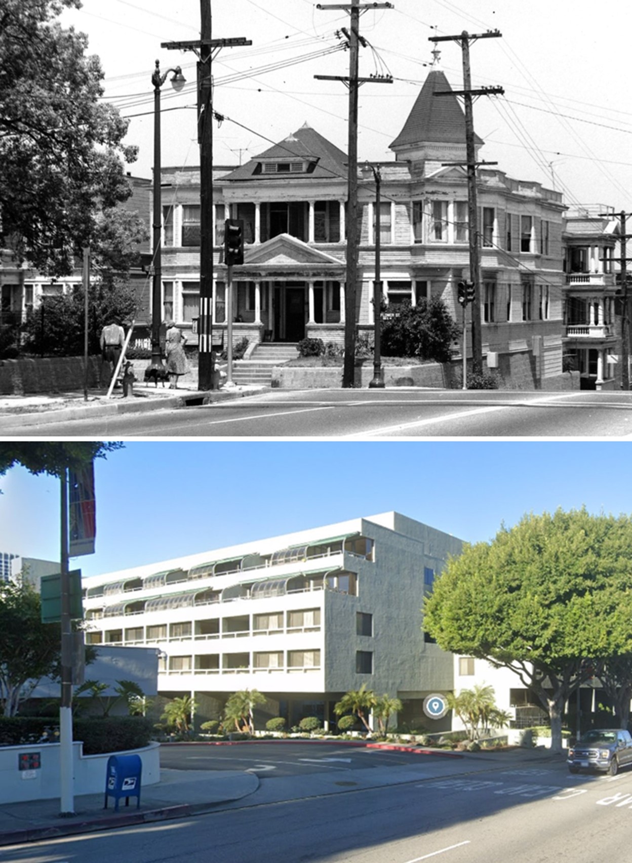 |
|
| (1955 vs. 2023)* – A "Then and Now" comparison of the southwest corner of 1st and Flower Streets in Bunker Hill, once home to Victorian-era apartment houses. Today, this site serves as the entryway to Bunker Hill Tower and the Promenade West Condominiums, located directly across the street from the DWP building. Photo comparison by Jack Feldman. |
| Historical Notes
Buildings shown in the 1955 images were removed during redevelopment in the 1960s. The land was cleared and prepared for higher-density construction, ending more than half a century of residential use on this corner. Bunker Hill Tower, completed in the late 1960s, introduced modern high-rise living to a site that had previously held wood-frame Victorian structures. The shift in scale and form reflects the broader redesign of Bunker Hill. |
* * * * * |
Flower Street Through Bunker Hill |
In the mid-1960s, Flower Street still ran through the heart of Bunker Hill, lined with apartments, hotels, and a tightly connected street grid. Within just a few years, nearly all of it would be erased and reshaped as part of one of the most sweeping redevelopment efforts in Los Angeles history. |
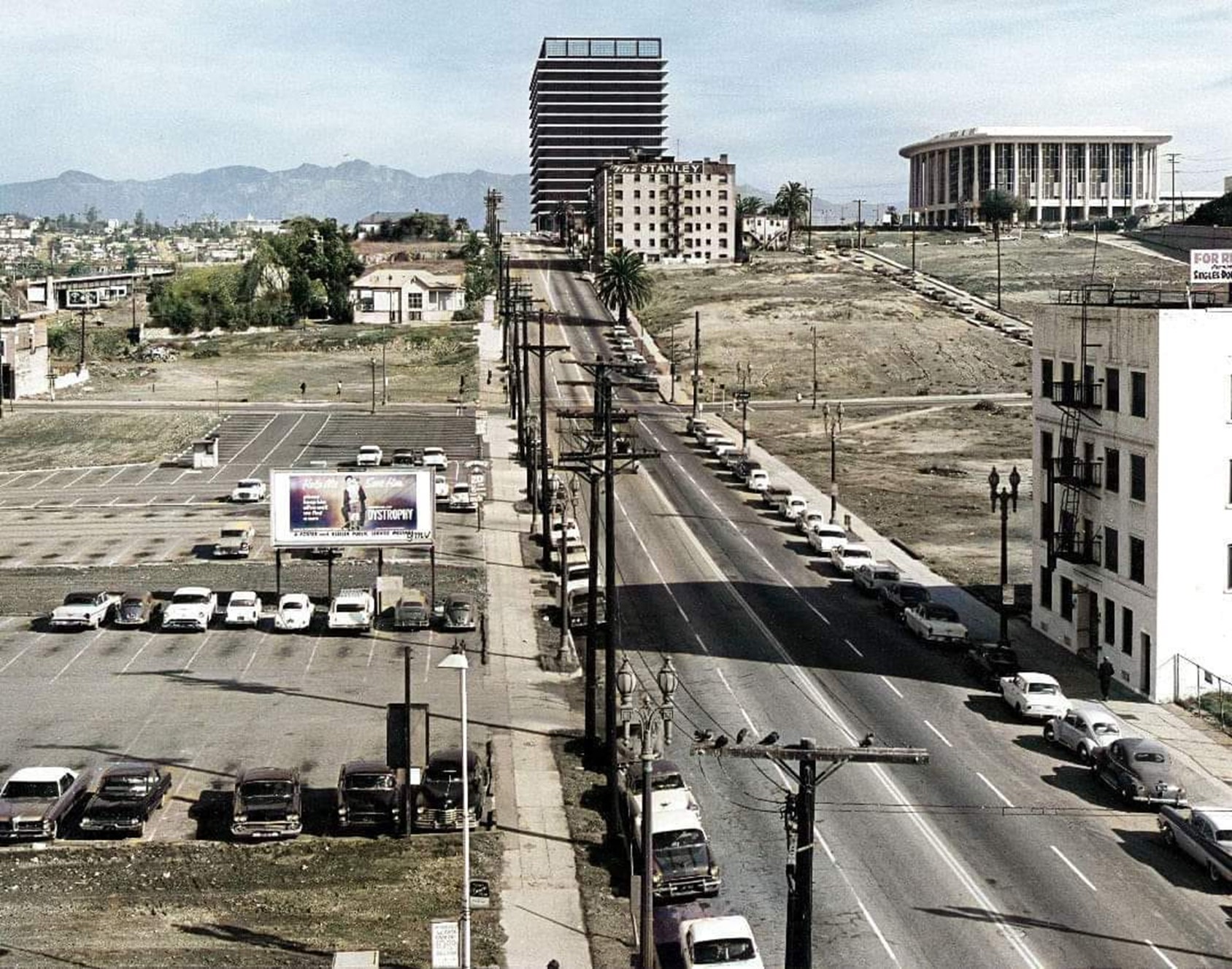 |
|
| (1965)* – View looking north on Flower Street from 4th Street through the Bunker Hill neighborhood. The newly completed Department of Water and Power Building appears at upper right near Hope and 1st Streets. Cinnabar Street descends between Flower and Hope from 2nd Street. The Stanley Hotel and Apartments stand at the southeast corner of Flower and 2nd Street. Photo by William Reagh. This image has been lightly colorized. See original B&W HERE. |
| Historical Notes
Flower Street once continued straight through Bunker Hill before being regraded and realigned. Cinnabar Street, seen between Flower and Hope, connected 2nd Street to the hilltop and was later removed during redevelopment. The Stanley Hotel and Apartments were among many residential buildings that defined the neighborhood prior to clearance. The Department of Water and Power Building, completed between 1963 and 1965, marked the beginning of large scale change on Bunker Hill. Today, Flower Street curves at 3rd Street and merges with Hope Street at 2nd Street. The original street grid of Bunker Hill has been largely replaced by a reconfigured network designed for modern development. |
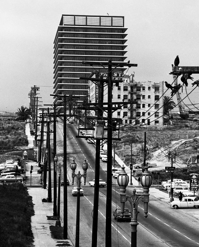 |
|
| (1966)* - Looking north from the 4th Street Bridge toward the top of Bunker Hill. The Department of Water and Power Building rises in the distance. Ornate two-lamp streetlights line both sides of Flower Street, and the Stanley Hotel and Apartments remain at the corner of 2nd Street. Pigeons rest on the overhead lines and pole at right. Photo by Lin Cariffe. |
| Historical Notes
By 1966, redevelopment pressures were increasing, though much of the original neighborhood fabric still remained. Flower Street retained its earlier alignment, with residential and commercial buildings continuing up the hill. None of the structures seen along this stretch of Flower Street remain today. The area has since been fully redeveloped with modern office, residential, and cultural buildings. |
* * * * * |
The End of Bunker Hill at Flower and 2nd |
By the mid-1960s, demolition had begun in earnest. Buildings that had stood for decades were removed block by block, revealing a landscape in transition. For a brief moment, the old neighborhood had disappeared, while the new city had yet to fully take shape. |
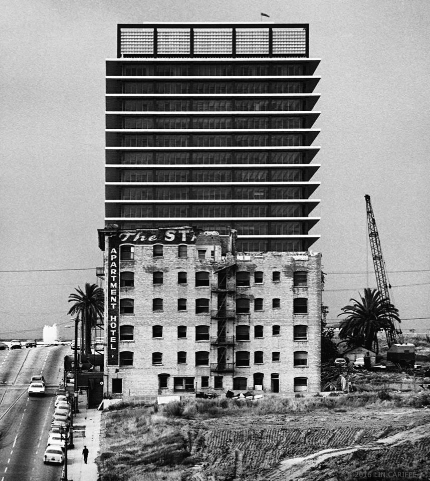 |
|
| (1966)* – View looking north showing the demolition of the Stanley Hotel and Apartments at the southeast corner of 2nd and Flower Streets. With the structure removed, the Department of Water and Power Building stands clearly visible one block to the north. Photo by Lin Cariffe. |
| Historical Notes
The Stanley Hotel and Apartments were demolished in 1966 as part of the Bunker Hill clearance. Their removal exposed the newly completed Department of Water and Power Building one block to the north. The site is now part of the redeveloped Bunker Hill district, with no visible trace of the earlier structures. |
 |
|
| (ca. 1967)* – View looking north from the southwest corner of 1st and Hope Streets. With much of Bunker Hill cleared, a lone bus bench sits in the foreground. The Department of Water and Power Building rises across the street, while the Music Center appears in the distance. |
| Historical Notes
By the late 1960s, large portions of Bunker Hill had been cleared, leaving open parcels awaiting redevelopment. Remaining street elements, including bus stops and utility lines, stood in stark contrast to the emerging civic and commercial buildings. Bunker Hill Tower, completed in 1968, would soon rise nearby as part of the new skyline. Those cleared parcels have since been filled with major civic and commercial development. |
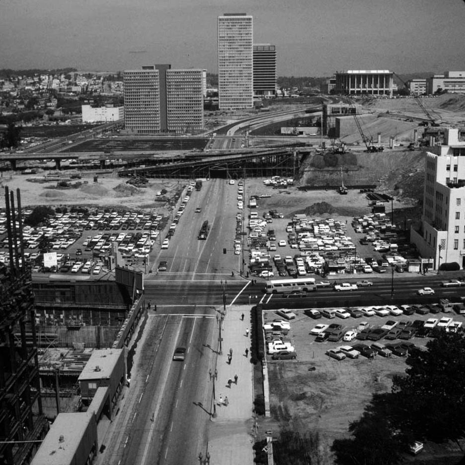 |
|
| (1970)* - View looking north along Flower Street from 6th Street. Bunker Hill Tower rises at top, with the Department of Water and Power Building and the Music Center beyond at right, as redevelopment begins to define the new skyline. |
| Historical Notes
By 1970, redevelopment was well underway, replacing the cleared parcels of the late 1960s with new high-rise construction. Bunker Hill Tower, completed in 1968, was among the first major residential towers built as part of the redevelopment project. This view captures the transition from an empty landscape to a newly emerging downtown skyline. |
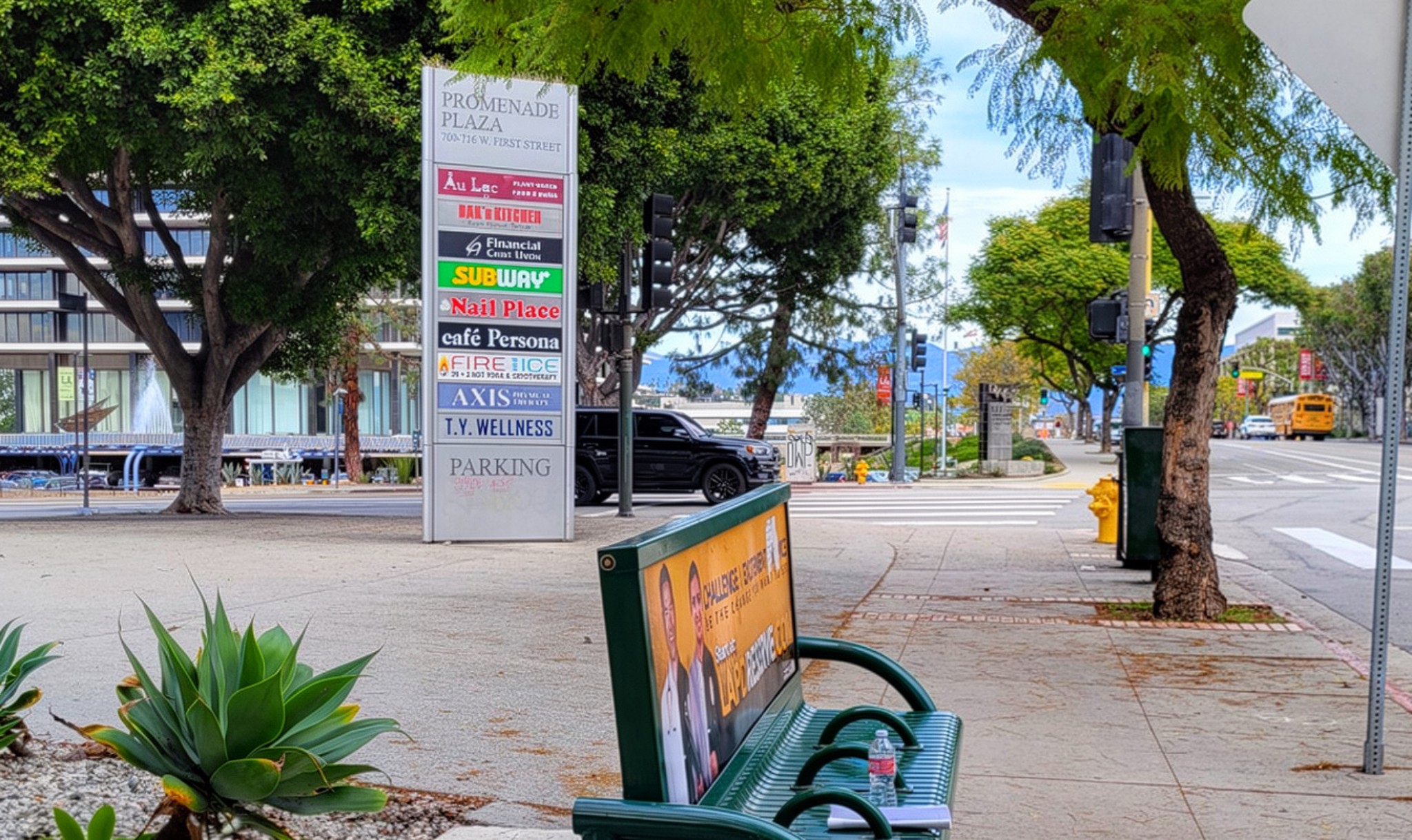 |
|
| (2024) - View looking north from the southwest corner of 1st and Hope Streets. The Department of Water and Power Building stands across the street on the left, with the Music Center to the right. While the skyline remains largely consistent with the late 1960s, the surrounding area is now fully built out with modern development. Contemporary photo by Jack Feldman. |
| Historical Notes
The cleared parcels seen in the late 1960s have since been replaced by a dense mix of civic, commercial, and residential development. The Department of Water and Power Building and the Music Center remain as defining landmarks, anchoring the view across time. The most significant changes have occurred at street level, where the former Bunker Hill neighborhood and its original street grid have been completely replaced. |
Then and Now
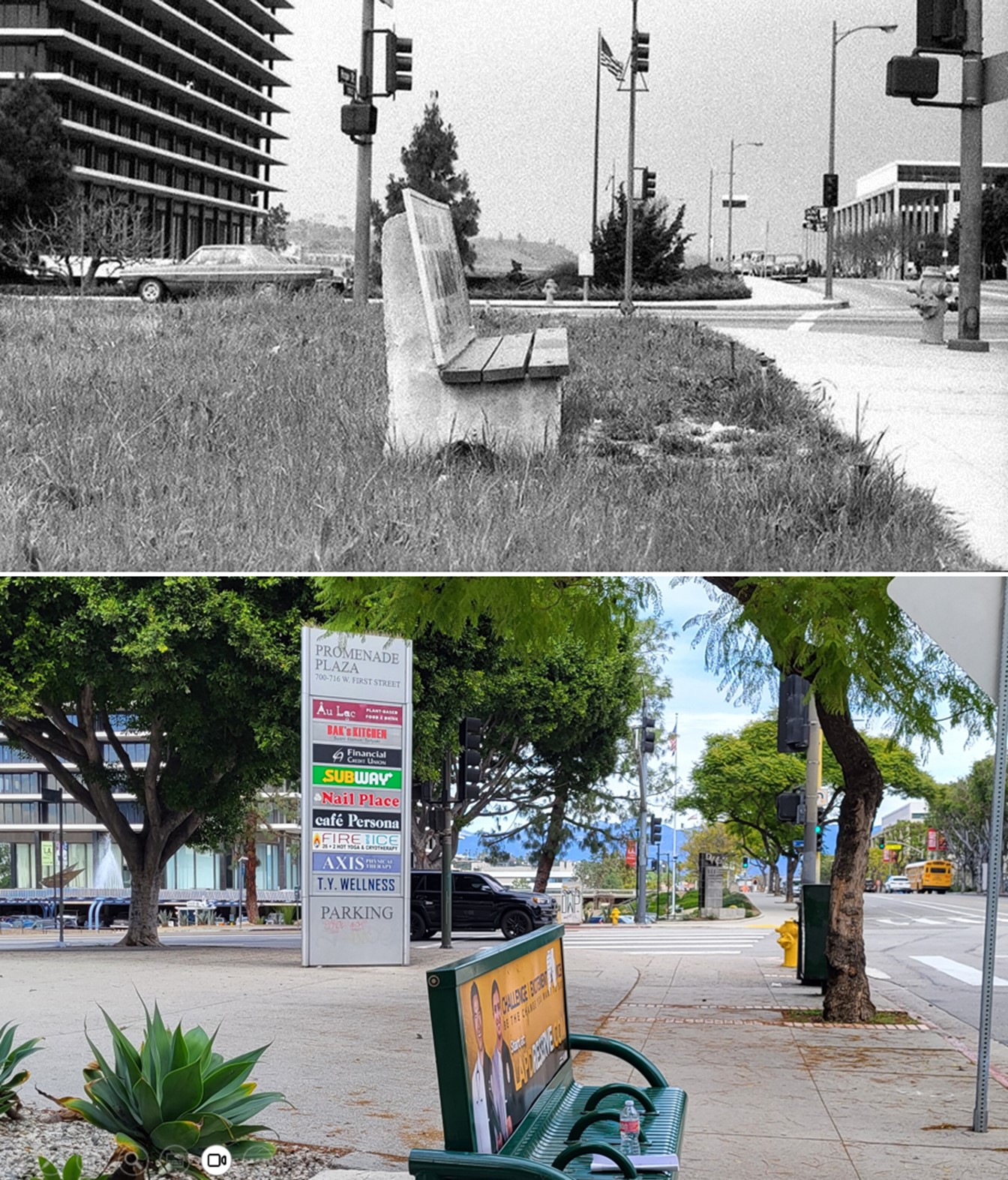 |
|
| (1967 vs 2024) – View looking north from the southwest corner of 1st and Hope Streets. The Department of Water and Power Building and the Music Center remain prominent in both views, while the cleared landscape of 1967 has given way to a fully built out downtown landscape. Photo comparison by Jack Feldman. |
| Historical Notes
The 1967 view captures Bunker Hill just after clearance, when much of the land in the foreground remained open. In contrast, the present day view shows the same area fully built out, even as the primary landmarks and overall skyline remain largely unchanged. The comparison shows how redevelopment reshaped the streets and ground level environment without significantly altering the distant skyline. |
* * * * * |
DWP Building and Dorothy Chandler Pavilion
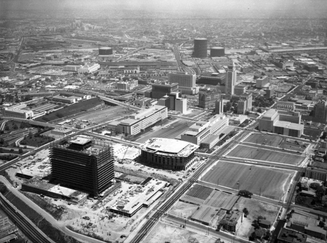 |
|
| (1963)* - Aerial view looking east showing Bunker Hill with the Dorothy Chandler Pavilion and DWP Building under construction. To the southeast are empty lots, one of which would later become the site of the Walt Disney Concert Hall. |
| Historical Notes
In 1963, both the DWP headquarters and Dorothy Chandler Pavilion were rising side by side in a bold civic vision for Bunker Hill. The 17-story DWP Building, designed by Albert C. Martin & Associates in the International / Modern style, would be completed in 1965, becoming one of the most visible landmarks in downtown Los Angeles. Meanwhile, the Dorothy Chandler Pavilion—now largely complete by this time—was already shaping the cultural identity of the Music Center. The adjacent vacant parcels hint at future ambitions for the site, including the eventual Walt Disney Concert Hall. |
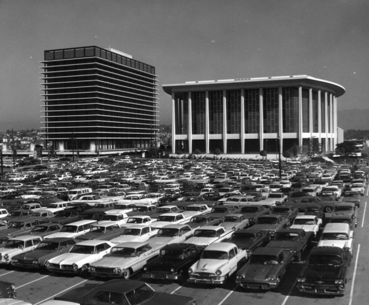 |
|
| (1967)* - The Department of Water and Power building and Dorothy Chandler Pavilion seen from a parking lot to the southeast, on land that would eventually host the Disney Concert Hall. |
| Historical Notes
By 1967, the DWP Building and the Chandler Pavilion had fully taken their place in the civic heart of Los Angeles. The Pavilion, completed in 1964 and designed by architect Welton Becket, became the initial focal point of the Los Angeles Music Center, hosting performances of the Philharmonic and major events like the Academy Awards from 1969 to 1999. The DWP Building, today known as the John Ferraro Building, served as a modern counterpart to the Pavilion—its sleek, vertical form balanced by the Pavilion’s more monumental, horizontal lines. The vantage from the parking lot underscores how much of the surrounding land remained undeveloped at that moment—waiting for future civic expansion. |
.jpg) |
|
| (1967)* – A closer look at the parking lot across from the DWP Building and Music Center, on what is now the Walt Disney Concert Hall site. |
| Historical Notes
This 1967 view shows the large parking lot that once stood across from the new DWP Building and Dorothy Chandler Pavilion. At the time, much of Bunker Hill was still being cleared and rebuilt, leaving open land waiting for future development. Decades later, this same site became home to the Walt Disney Concert Hall. Designed by Frank Gehry and funded through a major gift from Lillian Disney in 1987, the hall took years of planning and construction before finally opening in 2003. What was once a simple parking lot eventually became one of the most celebrated cultural landmarks in Los Angeles. |
* * * * * |
Cinnabar Street and the 3rd Street Tunnel |
Cinnabar Street once ran between 2nd and 3rd Streets on the western slope of Bunker Hill, connecting Grand Avenue to Flower Street. It was a short but active street lined with apartments and small structures typical of the neighborhood’s later years.By the early 1960s, redevelopment targeted the area. Streets were removed, grades were lowered, and the original layout of Bunker Hill was largely erased.Today, no physical trace of Cinnabar Street remains. A private roadway between 1st and 2nd Streets follows a similar north–south alignment but lies one block north of the former street. |
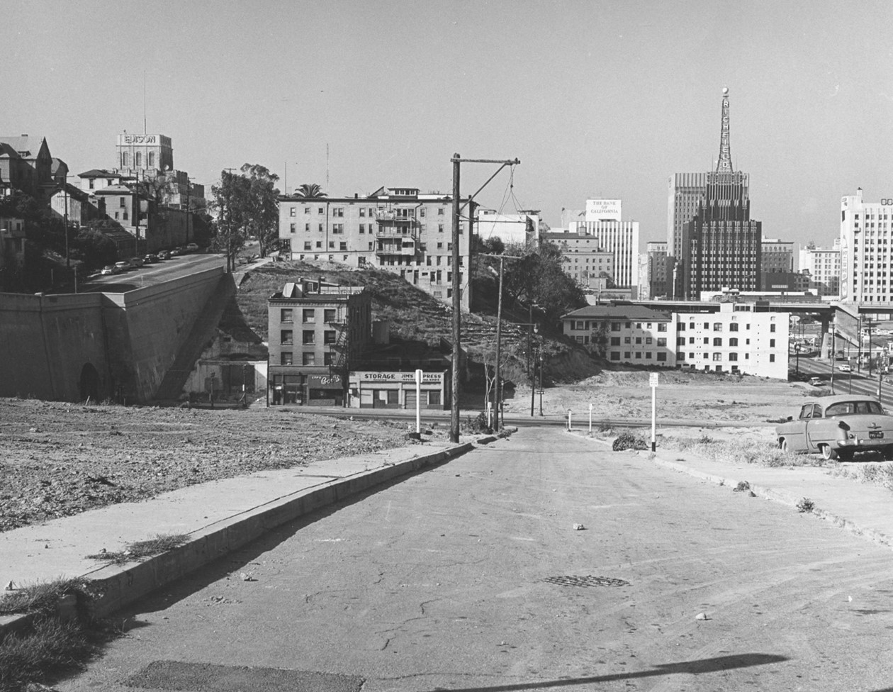 |
|
| (1964)* – View looking southwest on Cinnabar Street from near 2nd Street toward 3rd Street. The western portal of the 3rd Street Tunnel appears at left. Hope Street and the top of the Edison Building are visible at upper left, while the Richfield Building stands at center right. Photo by William Reagh. |
| Historical Notes
This view shows Cinnabar Street shortly before removal. The 3rd Street Tunnel, completed in 1901, provided a key passage through Bunker Hill and remains one of the few elements of the earlier landscape still in use. The Richfield Building, completed in 1929, would be demolished in 1968. Within a few years of this photograph, Cinnabar Street and surrounding structures were gone. Click HERE to see more early views of the western portal of the 3rd Street Tunnel. |
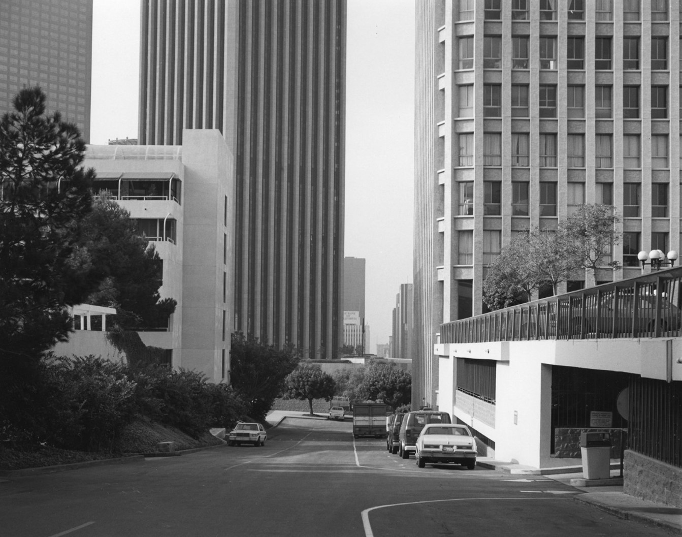 |
|
| (1988)* - View looking southwest along a private road between 1st and 2nd Streets, aligned roughly north–south in the same direction as the former Cinnabar Street. Promenade Plaza is at left and Bunker Hill Tower at right. |
| Historical Notes
By 1988, Cinnabar Street had been eliminated. The roadway seen here does not occupy its original location but reflects a similar alignment within the redeveloped landscape. The shift from a public street to internal access roads reflects the broader reconfiguration of Bunker Hill’s street grid during redevelopment. |
Before and After
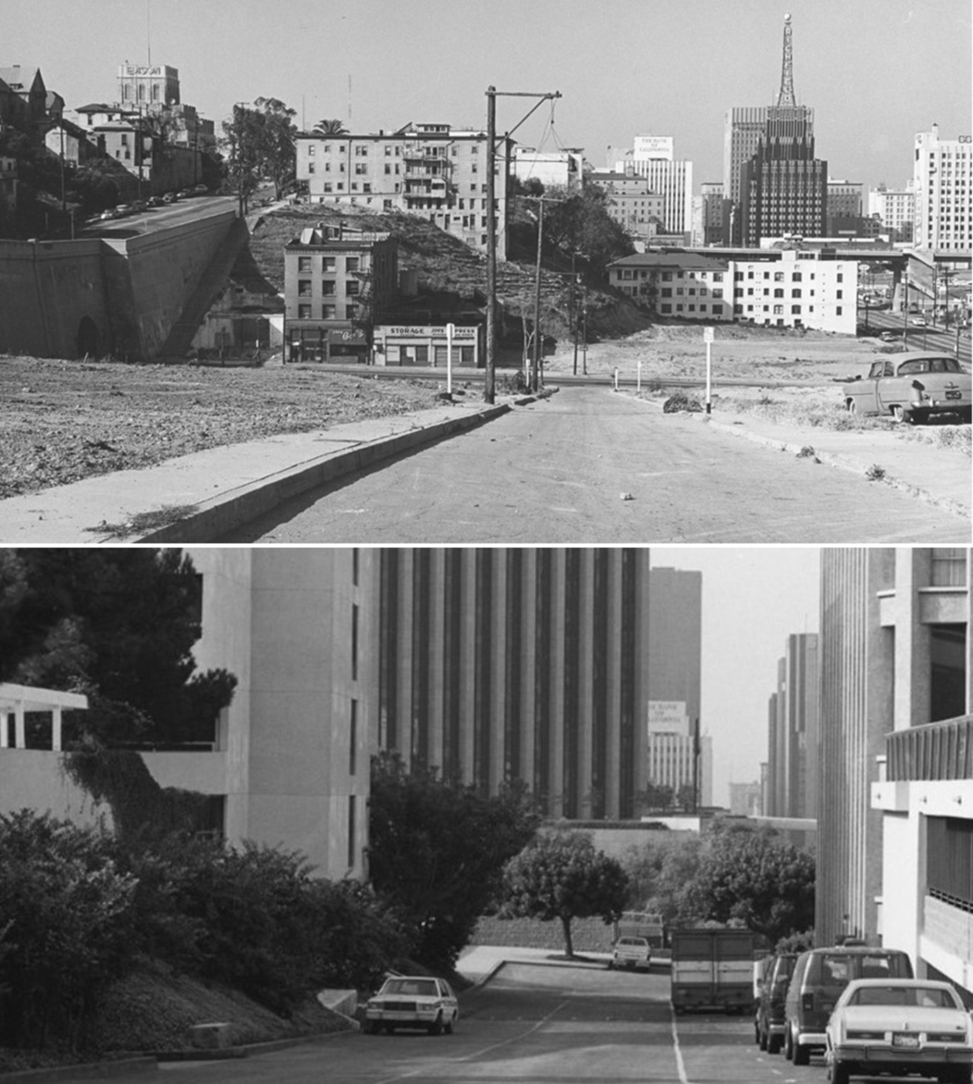 |
|
| (1964 vs 1980)* – Comparison looking southwest along the former alignment of Cinnabar Street. Photo comparison by Jack Feldman. |
| Historical Notes
The earlier view shows a developed street with buildings and pedestrian access. By 1980, that setting had been replaced by a reconfigured circulation pattern serving modern construction. The comparison also shows how grading altered the landscape. The original slope and street form no longer exist. |
* * * * * |
Clearing Bunker Hill (1960s Transformation) |
By the mid-1960s, large portions of Bunker Hill were being cleared under the city’s redevelopment program. Entire blocks were demolished to prepare the area for new construction.The Community Redevelopment Agency, established in 1955, directed the project. Land was regraded to create larger, level parcels. |
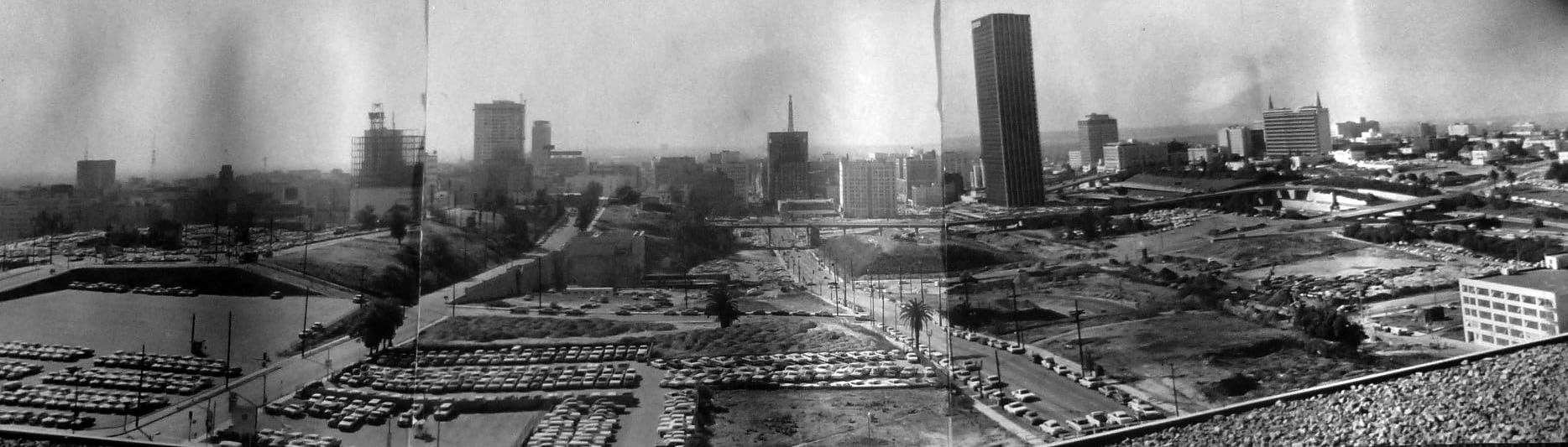 |
|
| (1967)* - Composite panoramic view from the fifth floor of the DWP Building, looking south across Bunker Hill. Hope Street is at left and Flower Street at center. Surface parking lots occupy the foreground. |
| Historical Notes
This image shows the extent of clearance by 1967. Areas once filled with homes and apartments had been reduced to open ground and temporary parking. Sites later occupied by Bunker Hill Tower and the Walt Disney Concert Hall appear here in an intermediate stage. Many parcels remained vacant for years. |
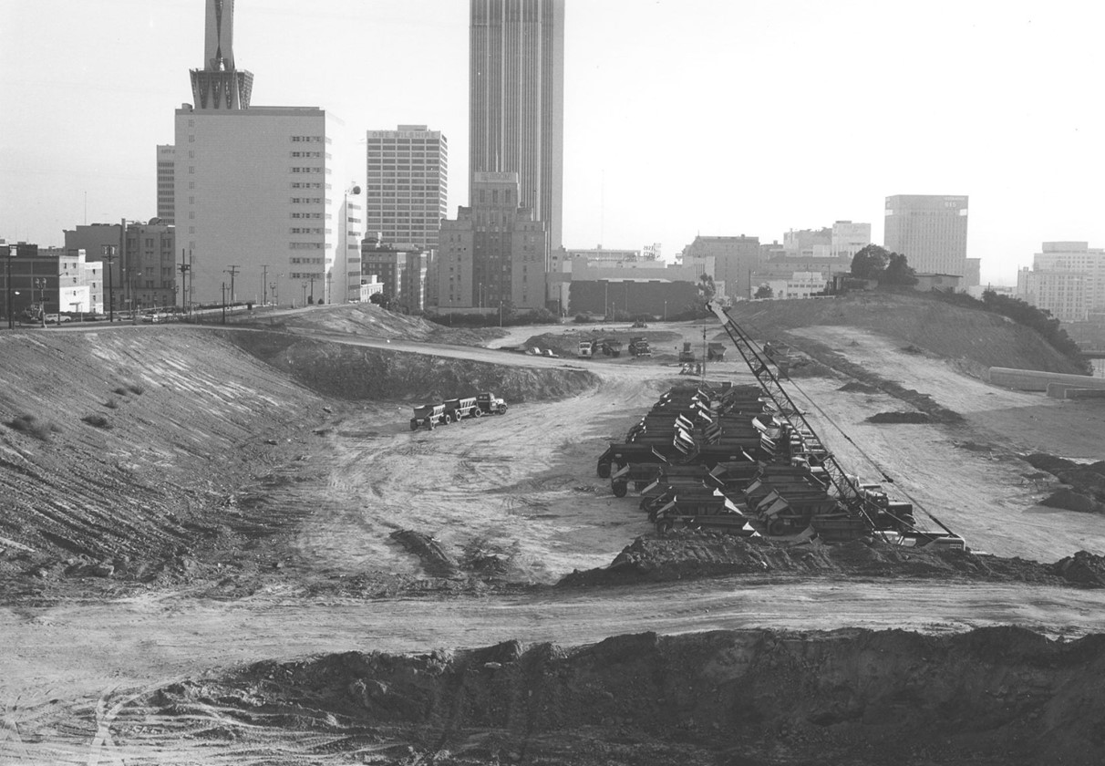 |
|
| (1967)* – View looking south across a cleared section of Bunker Hill, with trucks lined up in a large excavation area. The AT&T Switching Center (then PacBell Tower) and One Bunker Hill (Edison Building) are visible in the distance. Photo by William Reagh. |
| Historical Notes
Earthmoving operations reshaped the hill during this period. In some areas, up to thirty feet of material was removed to create level building sites. Within a few years, most of the original residential neighborhood had been cleared and replaced by the open landscape seen here. |
* * * * * |
Rise of the Skyline (Late 1960s–1970s) |
Following clearance, Bunker Hill entered a new phase defined by large-scale construction. High-rise buildings replaced earlier structures, introducing a different pattern of land use and density.This period established much of the skyline that defines the area today. |
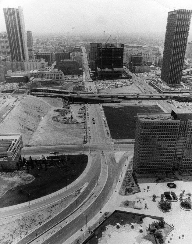 |
|
| (ca. 1970)* – View looking south down Flower Street as seen from the Bunker Hill Tower. At lower-right (NW corner of Flower and 3rd St) are the Bunker Hill Apartments. Also seen here is the Union Bank Building (upper-right), Citizens Citizens-Bank (upper-left) and the additional onramp construction at 4th Street. |
| Historical Notes
Bunker Hill Tower, completed in 1968, was among the first major developments of the redevelopment era. Its 32-story height marked a clear departure from earlier low-rise structures. Flower Street had been rebuilt as a major arterial. Freeway-related construction at 4th Street reflects the increasing role of automobile access in the redesigned area. |
|
|
| (1970)* - View from atop the Bank of California Building, looking north along Flower Street from 6th Street to the additional onramp construction at 4th Street. Prominent buildings in the background from left to right are the Bunker Hill Apartments and Tower, Los Angeles Department of Water and Power, and the Music Center. |
| Historical Notes
By 1970, key elements of the new Bunker Hill were in place. The DWP Building (1965) and the Dorothy Chandler Pavilion (1964) established the area’s civic and cultural role. Large portions of land remained undeveloped, reflecting the extended timeline of redevelopment. |
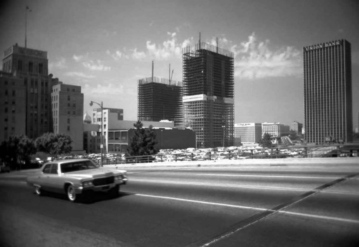 |
|
| (1970)* – View looking SW across Grand Avenue showing the ARCO Towers under construction with the Edison Building seen on the left and Union Bank Building on the right. Photo by Leo Zahn |
| Historical Notes
The ARCO Towers were built on the site of the Richfield Building (1928, demolished 1968), an Art Deco masterpiece. Upon completion in 1972, the ARCO Plaza towers were the tallest buildings in the city for one year before being overtaken by Aon Center, and were the tallest twin towers in the world until the completion of the World Trade Center in New York City. The towers are the tallest twin buildings in the United States outside of New York City, where the 55-floor Time Warner Center stands at 750 ft. |
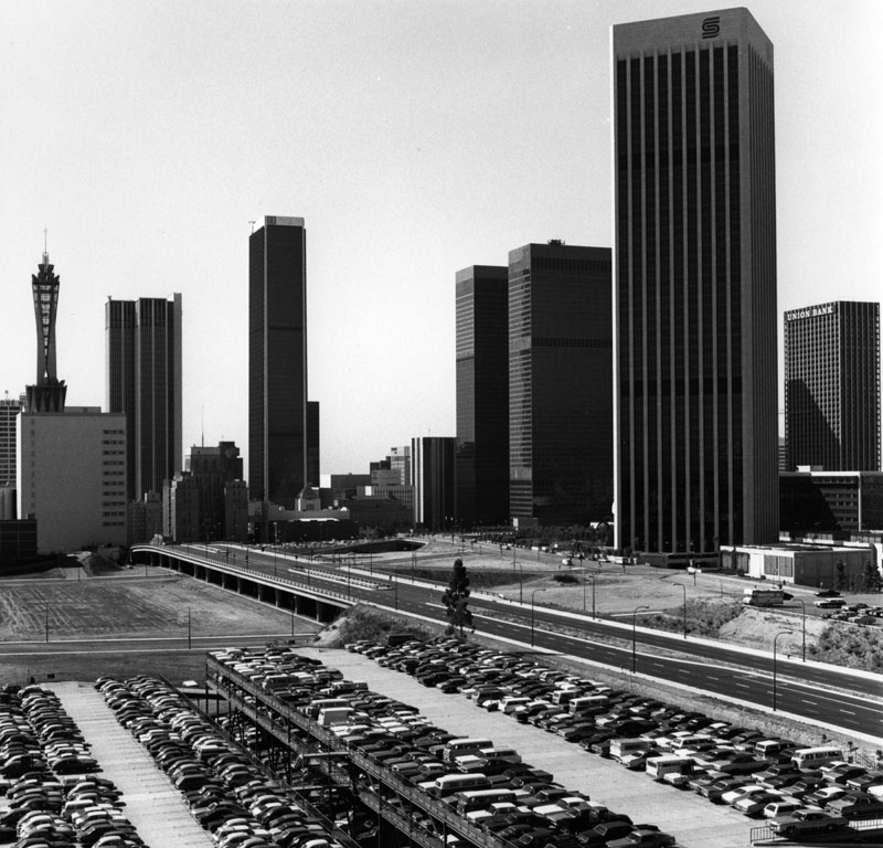 |
|
| (1982)* - View showing the four-lane Grand Avenue looking south. Several high-rise buildings can be seen throughout. On the right, a tall building under construction, and on the left, the PacBell Tower located at 420 S. Grand Avenue. Also seen are: the Edison Building, Los Angeles Central Library, Aon Center, ARCO Towers, Crocker-Citizens Bank Building, UBC (United California Bank) and Union Bank. |
| Historical Notes
By the early 1980s, redevelopment had largely reshaped Bunker Hill. High-rise buildings and wide streets replaced the earlier network of smaller structures. The area had transitioned into a center of business, culture, and government activity. |
* * * * * |
Last Houses on the Hill |
By 1969, nearly all of Bunker Hill had been cleared. Two structures remained—known as the Castle and the Saltbox—standing alone on open ground with new civic buildings rising behind them.Both were relocated to Heritage Square in March 1969 in an effort to preserve part of the neighborhood’s architectural history. |
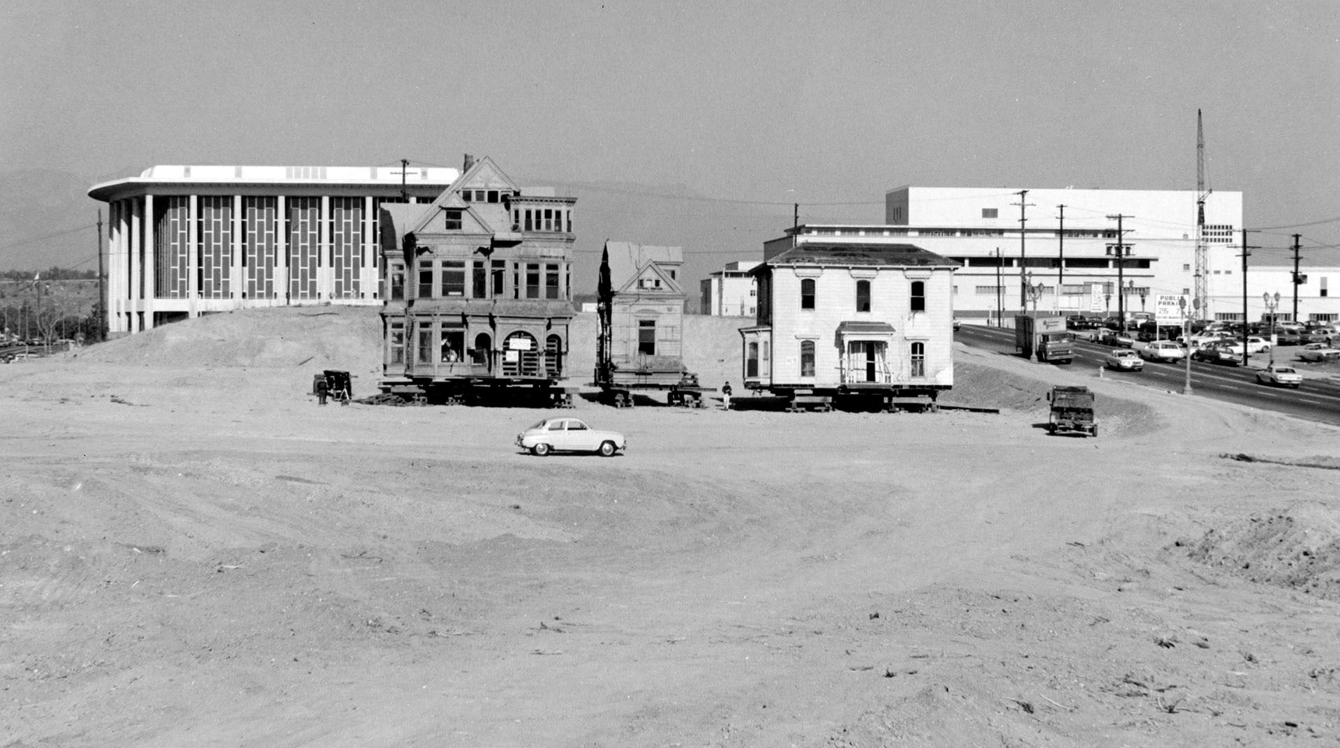 |
|
| (1969)* - View of the last remaining residences on Bunker Hill, known as the Castle and the Saltbox. The Dorothy Chandler Pavilion and the Stanley Mosk Courthouse appear in the background. |
| Historical Notes
These buildings were among the final residential structures from the original neighborhood. Their isolation reflects the extent of clearance completed by the late 1960s. Both were destroyed by fire later that year after relocation. Their loss marked the end of Bunker Hill’s remaining residential past. Click HERE to see more. |
* * * * * |
Bunker Hill Redevelopment - 1971 |
By 1971, Bunker Hill had entered a new phase. Much of the earlier neighborhood had been cleared, and the first major buildings were in place.Photographs from that year show a landscape in transition. Civic structures stood alongside large areas of open land where construction had not yet begun.Views from the entry bridge of the John Ferraro Building provide a consistent vantage point. These images allow the same scene to be followed over time as the skyline developed. |
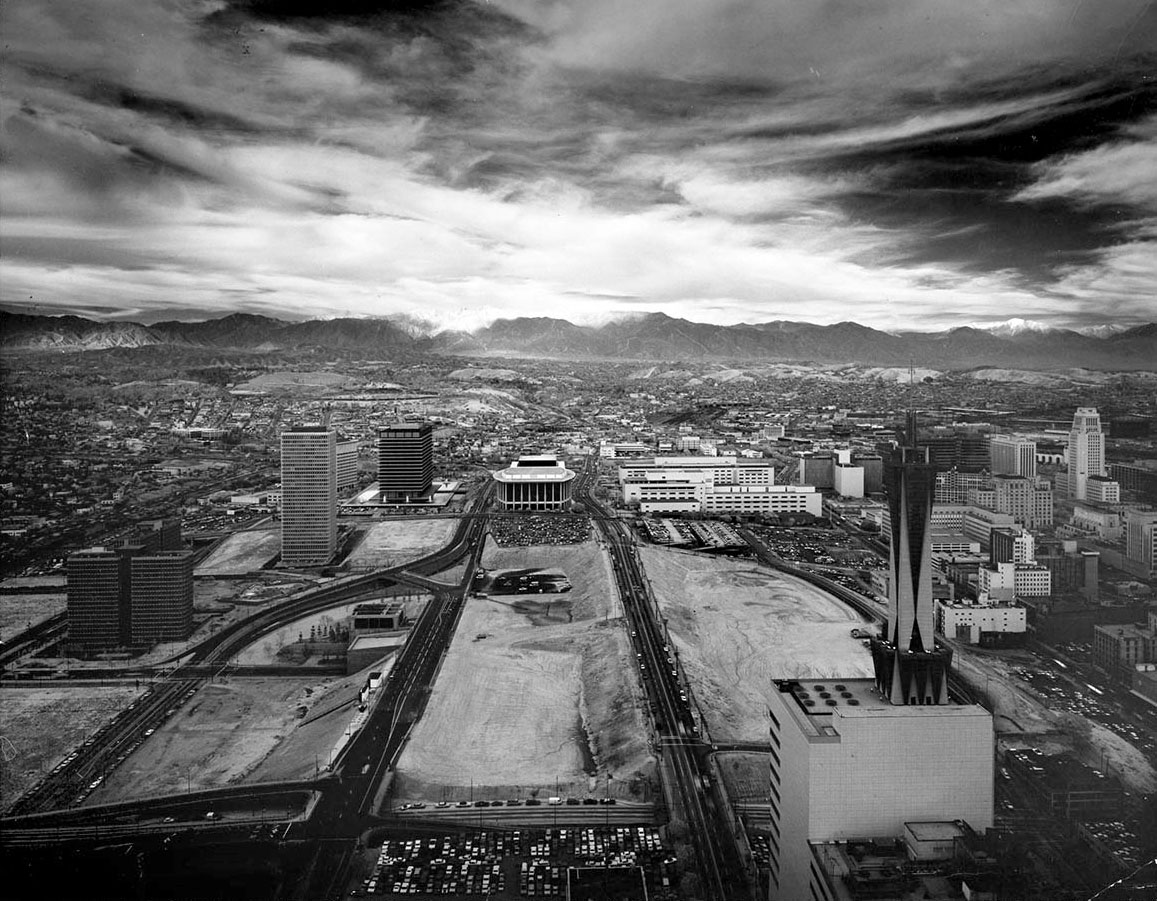 |
|
| (1971)* – View looking north over the Bunker Hill redevelopment area. From left to right are Bunker Hill Tower, the DWP Building, the Music Center, the Los Angeles County Courthouse, the California State Building, the Federal Building, and City Hall. The AT&T Madison Complex appears in the lower right foreground. Photo by Julius Shulman. |
| Historical Notes
By 1971, major civic buildings had been completed. The DWP General Office Building opened in 1964. The Music Center followed with the Dorothy Chandler Pavilion in 1964, the Ahmanson Theatre in 1967, and the Mark Taper Forum in 1967. Open land remained between these structures. Much of Bunker Hill had been cleared but not yet rebuilt. |
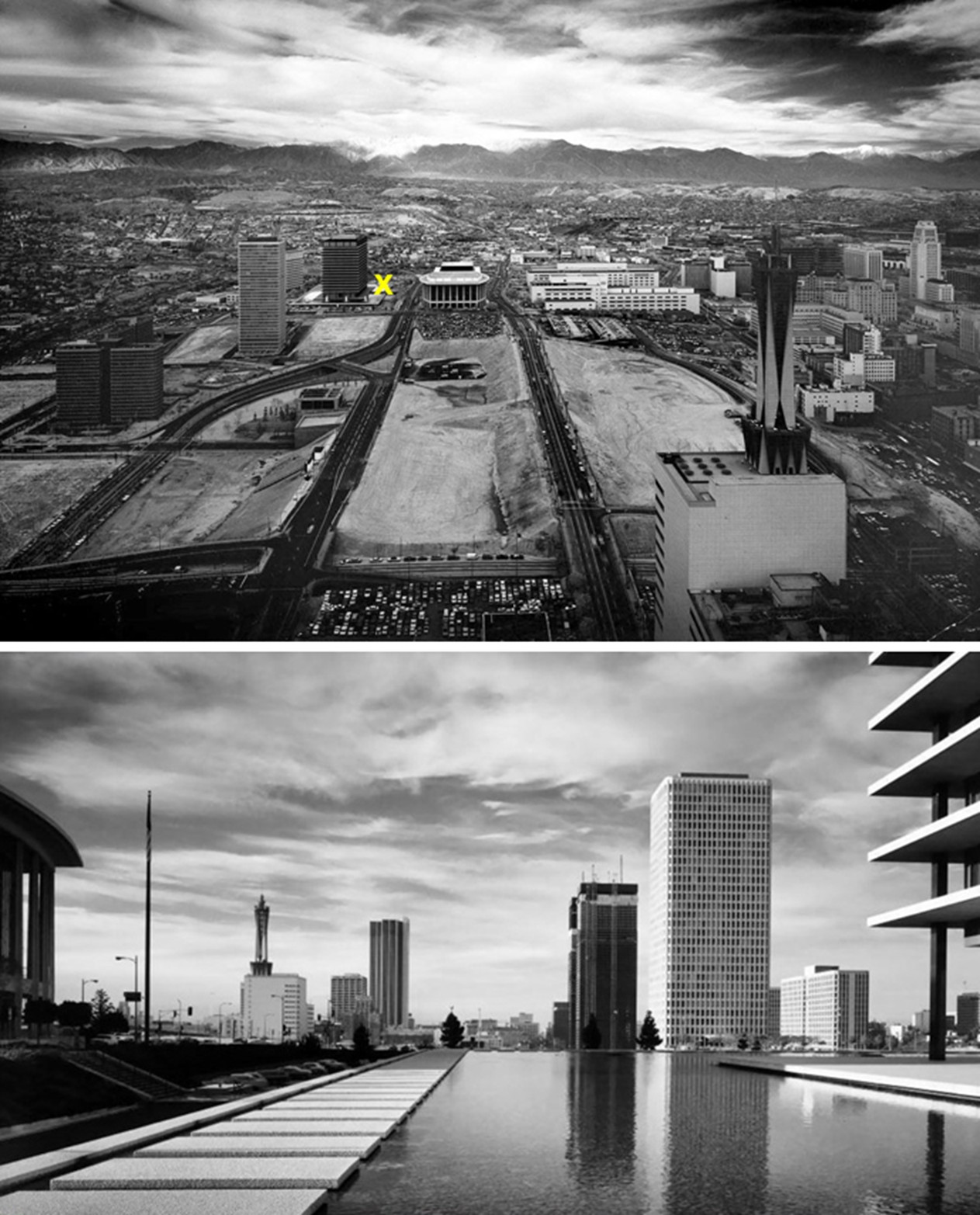 |
|
| (1971)* - Two views of Bunker Hill taken by Julius Shulman from opposite directions. The upper image marks the vantage point of the lower view, looking south from the DWP entry bridge. |
| Historical Notes
These images show the redevelopment area from both directions. The north view highlights civic buildings, while the south view shows the early stage of the office district. Between these points lay cleared parcels awaiting construction. Development proceeded in phases over many years. |
* * * * * |
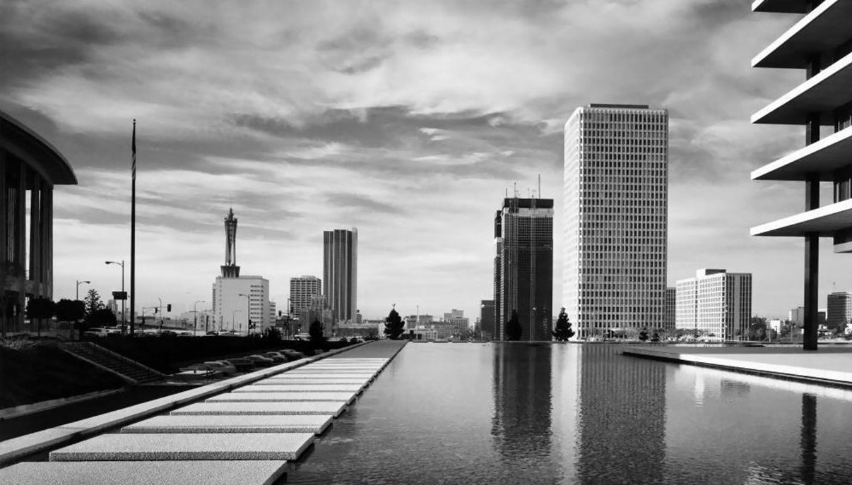 |
|
| (1971)* - View looking south from the DWP entry bridge, with the ARCO Plaza towers under construction in the distance. Photo by Julius Shulman. |
| Historical Notes
The ARCO Plaza towers were completed in 1972, rising on the site of the Richfield Building, which had been demolished in 1968. This view shows the downtown office core beginning to take shape on land that had been cleared only a few years earlier. |
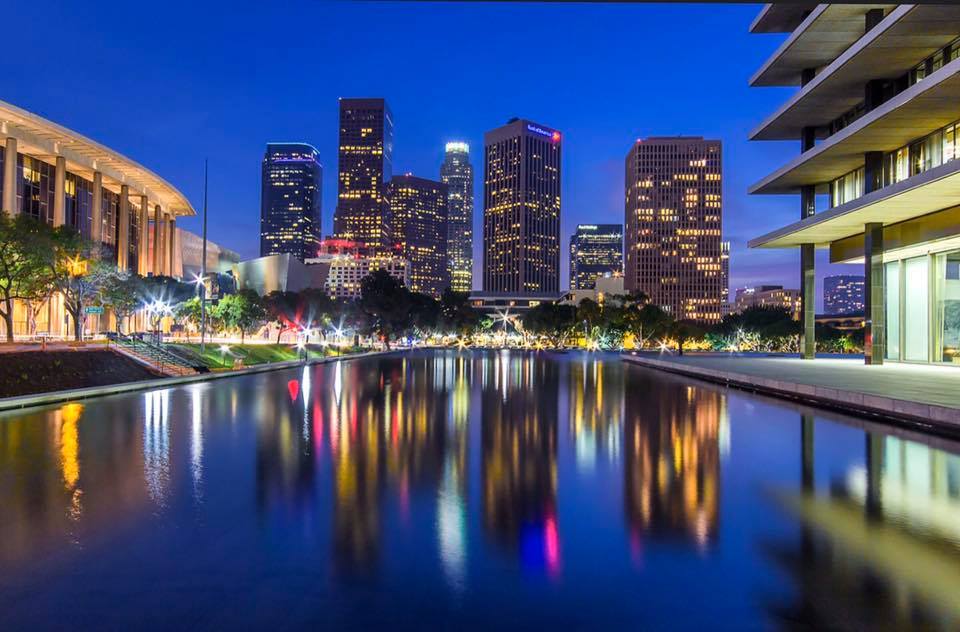 |
|
| (2019)* - View looking south from the DWP entry bridge showing a more developed skyline. Photo by Tom Awai. |
| Historical Notes
By 2019, the skyline had grown considerably. Office and residential towers now filled much of the land that had sat open for years after clearance. City National Plaza, formerly ARCO Plaza, remained a central feature, now surrounded by a much denser cluster of buildings. |
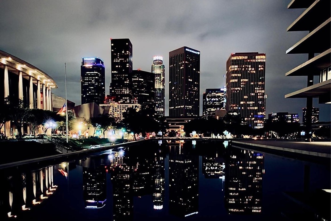 |
|
| (2025)* - View looking south from the DWP entry bridge showing the current Bunker Hill skyline. Photo by Carlos G. Lucero. |
| Historical Notes
Recent construction has filled in much of what remained. The skyline is now nearly continuous from one end of Bunker Hill to the other. The district today serves a mix of office, residential, and cultural uses — a far cry from the residential neighborhood that once covered the hill. |
Then and Now
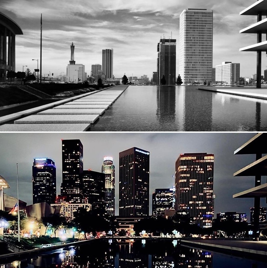 |
|
| (1971 vs 2025)* - View looking south toward the Bunker Hill skyline from the DWP entry bridge. Photo comparison by Jack Feldman. |
| Historical Notes
In 1971, a handful of towers stood among large stretches of open land. By 2025, the skyline is nearly continuous from one end of the hill to the other. This single comparison captures more than fifty years of change, from the first clearance of the 1950s to the fully built out district seen today. |
Then and Now
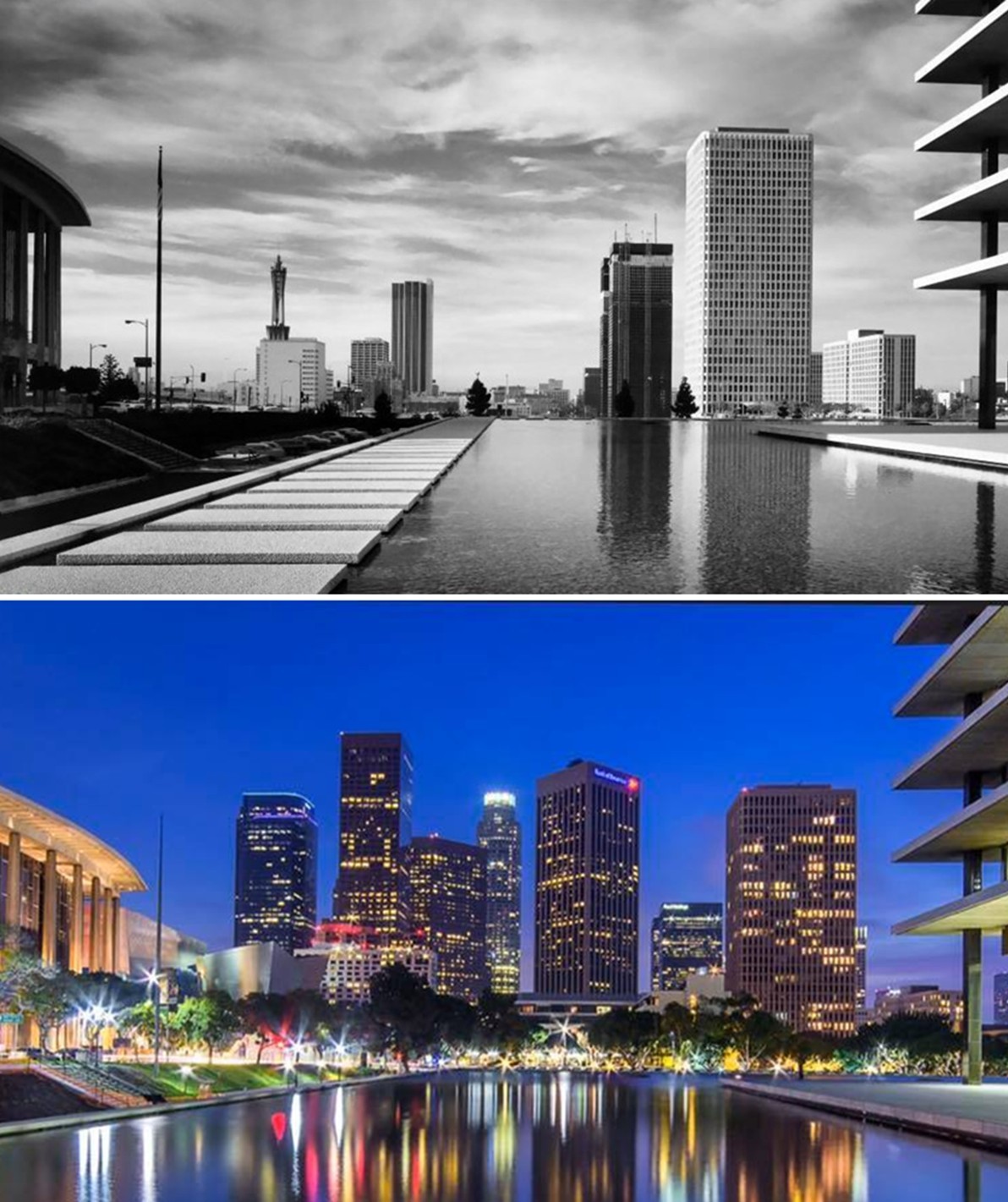 |
|
| (1971 vs 2019)* - View looking south toward Bunker Hill from the DWP entry bridge showing an intermediate stage of development. Photo comparison by Jack Feldman. |
| Historical Notes
By 2019, most of the major structures were in place, though construction continued to add density in the remaining open parcels. The comparison is a good reminder that redevelopment did not happen all at once. It unfolded in stages over more than five decades. |
Research, writing, image curation by Jack Feldman, Water and Power Associates, with editorial assistance.
* * * * * |
|
Other Sections of Interest |
|
Water and Power in Early LA |
|
Newest Additions |
New Search Index |

A new SEARCH INDEX has been added to help navigate through the thousands of topics and images found in our collection. Try it out for a test run.
Click HERE for Search Index |
* * * * * |
< Back